Assessing Geomorphological Changes and Oil Extraction Impacts in Abandoned Yellow River Estuarine Tidal Flats Using Cloud Coverage in Region of Interest (CCROI) and WDM
Abstract
1. Introduction
2. Materials and Methods
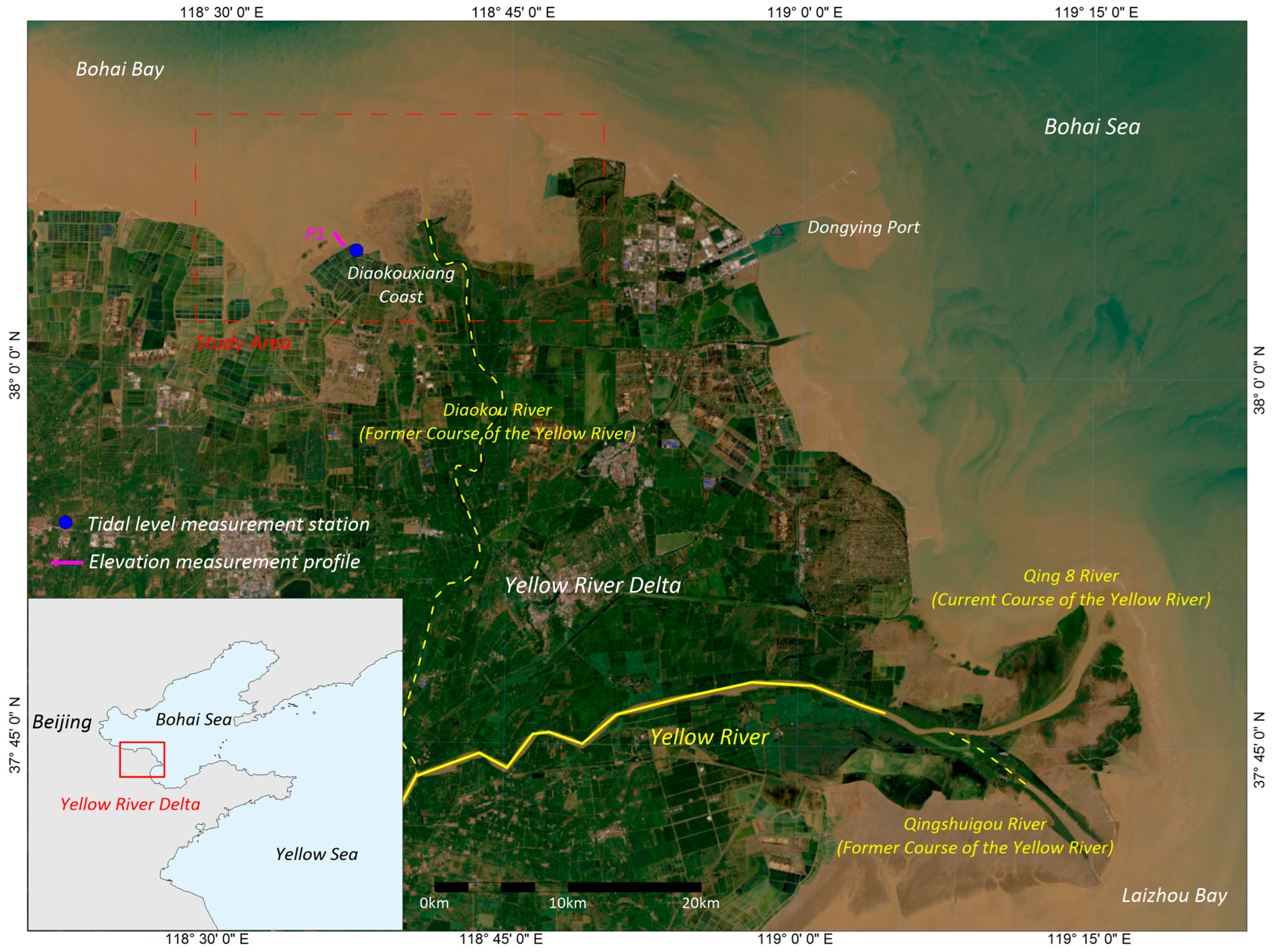
2.1. Study Area
2.2. Materials
2.2.1. Satellite Images
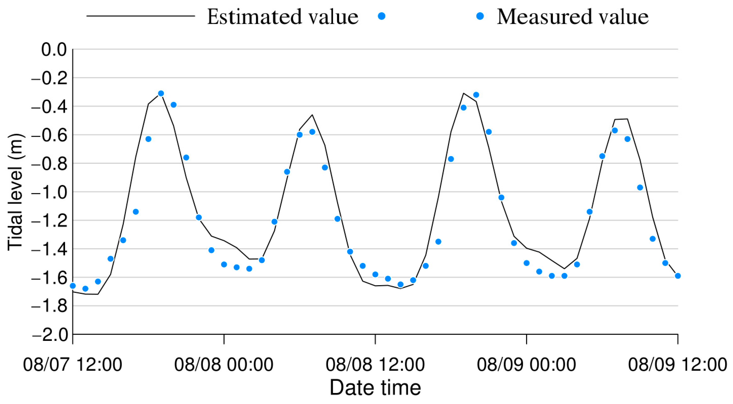
2.2.2. Tidal Level
2.2.3. Profile Elevation
2.3. Methods
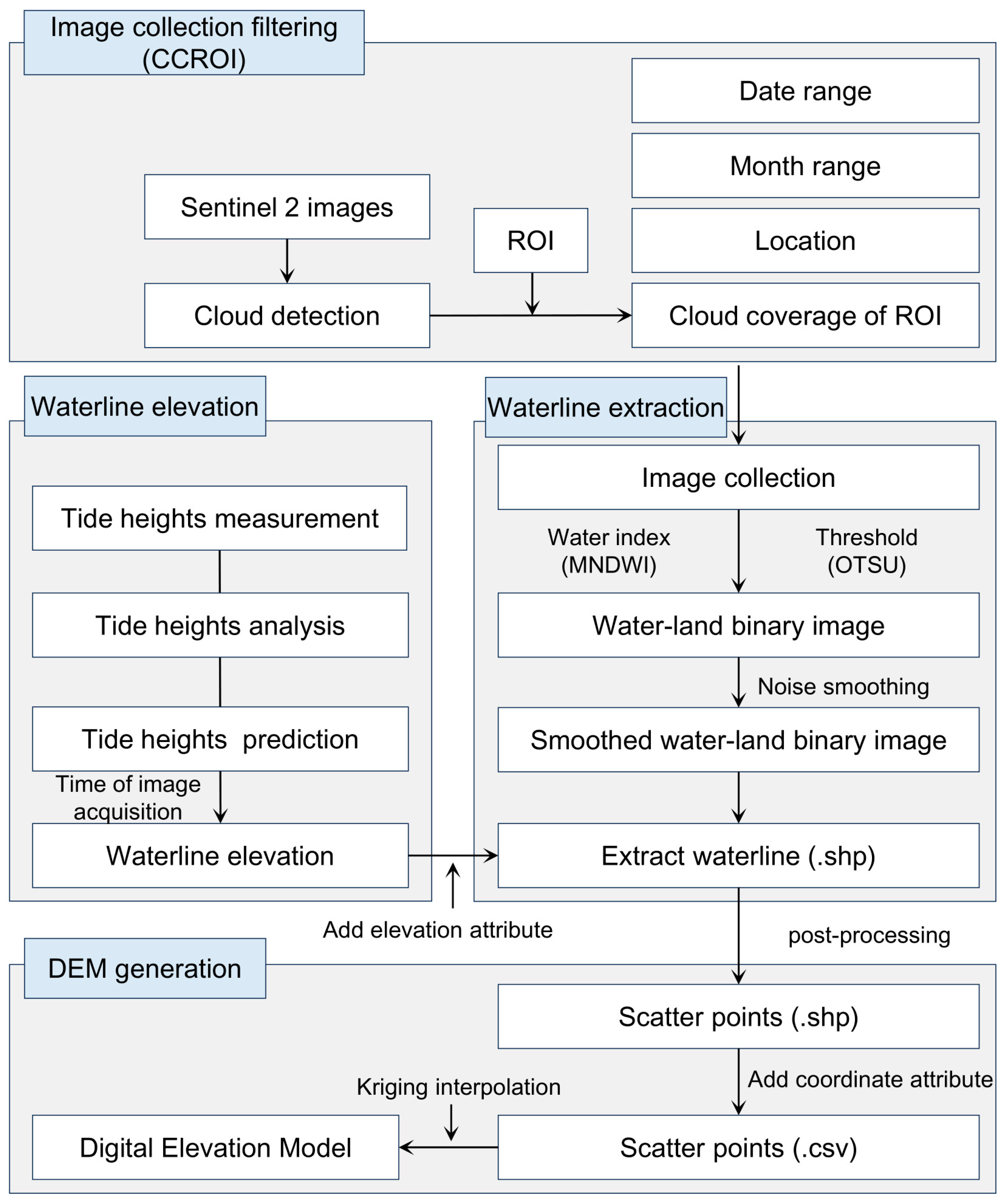
2.3.1. Waterline Detection Method (WDM)
2.3.2. Waterline Extraction Platform
2.3.3. Image Collection Filtering with CCROI
2.3.4. Water–Land Binary Image
2.3.5. Noise Smoothing of Binary Image
2.3.6. Waterline Extraction
2.3.7. Waterline Elevation
2.3.8. Waterline Post-Processing and DEM Generation
3. Results
3.1. Digital Elevation Model Products
3.2. Accuracy Verification of DEM
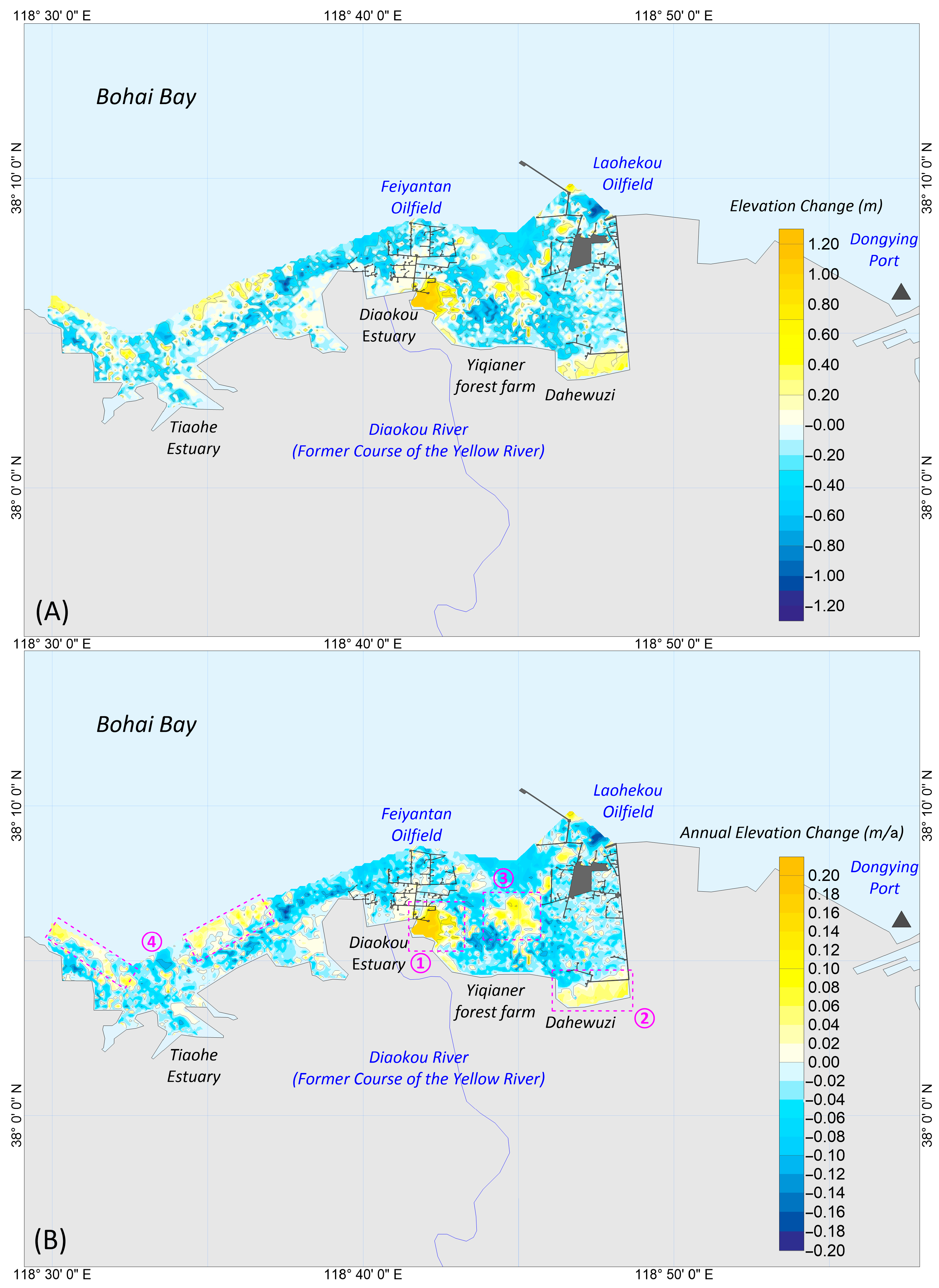
3.3. Recent Changes of the ETFADC
4. Discussion
4.1. Filtration Effects and Application Prospects of the CCROI Method
4.2. Influencing Factors of the ETFADC’s Recent Geomorphological Evolution
4.3. Impact of Oil Extraction on the ETFADC
4.4. Uncertainties and Limitations
4.5. Application Scenario
5. Conclusions
Author Contributions
Funding
Institutional Review Board Statement
Informed Consent Statement
Data Availability Statement
Acknowledgments
Conflicts of Interest
References
- Mason, D.C.; Gurney, C.; Kennett, M. Beach Topography Mapping: A Comparison of Techniques. J. Coast. Conserv. 2000, 6, 113–124. [Google Scholar] [CrossRef]
- Gao, W.; Shen, F.; Tan, K.; Zhang, W.; Liu, Q.; Lam, N.S.N.; Ge, J. Monitoring terrain elevation of intertidal wetlands by utilising the spatial-temporal fusion of multi-source satellite data: A case study in the Yangtze (Changjiang) Estuary. Geomorphology 2021, 383, 107683. [Google Scholar] [CrossRef]
- Mason, D.C.; Davenport, I.J.; Robinson, G.J.; Flather, R.A.; McCartney, B.S. Construction of an inter-tidal digital elevation model by the ‘Water-Line’ Method. Geophys. Res. Lett. 1995, 22, 3187–3190. [Google Scholar] [CrossRef]
- Xu, N.; Ma, Y.; Yang, J.; Wang, X.H.; Wang, Y.; Xu, R. Deriving Tidal Flat Topography Using ICESat-2 Laser Altimetry and Sentinel-2 Imagery. Geophys. Res. Lett. 2022, 49, e2021G–e96813G. [Google Scholar] [CrossRef]
- Pacheco, A.; Horta, J.; Loureiro, C.; Ferreira, Ó. Retrieval of nearshore bathymetry from Landsat 8 images: A tool for coastal monitoring in shallow waters. Remote Sens. Environ. 2015, 159, 102–116. [Google Scholar] [CrossRef]
- Salameh, E.; Frappart, F.; Turki, I.; Laignel, B. Intertidal topography mapping using the waterline method from Sentinel-1 & -2 images: The examples of Arcachon and Veys Bays in France. ISPRS-J. Photogramm. Remote Sens. 2020, 163, 98–120. [Google Scholar]
- Shih, S.; Hsu, W.; Hsu, Y. Waterline digital elevation model development to quantify inundation duration and coastal protection of tidal wetlands. Sci. Total Environ. 2023, 874, 162519. [Google Scholar] [CrossRef]
- Cao, J.; Liu, Q.; Yu, C.; Chen, Z.; Dong, X.; Xu, M.; Zhao, Y. Extracting waterline and inverting tidal flats topography based on Sentinel-2 remote sensing images: A case study of the northern part of the North Jiangsu radial sand ridges. Geomorphology 2024, 461, 109323. [Google Scholar] [CrossRef]
- Lee, J.; Kim, K.; Kwak, G.; Baek, W.; Jang, Y.; Ryu, J. Optimization of a multi-sensor satellite-based waterline method for rapid and extensive tidal flat topography mapping. Estuar. Coast. Shelf Sci. 2025, 318, 109235. [Google Scholar] [CrossRef]
- McAllister, E.; Payo, A.; Novellino, A.; Dolphin, T.; Medina-Lopez, E. Multispectral satellite imagery and machine learning for the extraction of shoreline indicators. Coast. Eng. 2022, 174, 104102. [Google Scholar] [CrossRef]
- Scala, P.; Manno, G.; Ciraolo, G. Semantic segmentation of coastal aerial/satellite images using deep learning techniques: An application to coastline detection. Comput. Geosci. 2024, 192, 105704. [Google Scholar] [CrossRef]
- Otsu, N. A Threshold Selection Method from Gray-Level Histograms. IEEE Trans. Syst. Man Cybern. 1979, 9, 62–66. [Google Scholar] [CrossRef]
- Jia, M.; Wang, Z.; Mao, D.; Ren, C.; Wang, C.; Wang, Y. Rapid, robust, and automated mapping of tidal flats in China using time series Sentinel-2 images and Google Earth Engine. Remote Sens. Environ. 2021, 255, 112285. [Google Scholar] [CrossRef]
- Zhao, B.; Liu, Y.; Wang, L.; Liu, Y.; Sun, C.; Fagherazzi, S. Stability evaluation of tidal flats based on time-series satellite images: A case study of the Jiangsu central coast, China. Estuar. Coast. Shelf Sci. 2022, 264, 107697. [Google Scholar] [CrossRef]
- Chen, Y.; Wang, S. LogiTide2DEM: A method for reconstructing intertidal topography in complex tidal flats using logistic regression with multi-temporal Sentinel-2 and Landsat imagery. Int. J. Appl. Earth Obs. Geoinf. 2025, 139, 104561. [Google Scholar] [CrossRef]
- Chen, C.; Sun, W.; Yang, Z.; Yang, G.; Jia, M.; Zhang, Z.; Liang, J.; Chen, Y.; Ren, T.; Hu, X.; et al. Tracking dynamics characteristics of tidal flats using landsat time series and Google Earth Engine cloud platform. Resour. Conserv. Recycl. 2024, 209, 107751. [Google Scholar] [CrossRef]
- Zheng, X.; Zhou, B.; Lei, H.; Jin, Y.; Su, Q. Mapping tidal flat topography using time-series Sentinel-2 images and ICESat-2 data: A case study in Cixi City. Ocean Coast. Manag. 2024, 256, 107278. [Google Scholar] [CrossRef]
- Chen, C.; Zhang, C.; Tian, B.; Wu, W.; Zhou, Y. Tide2Topo: A new method for mapping intertidal topography accurately in complex estuaries and bays with time-series Sentinel-2 images. ISPRS-J. Photogramm. Remote Sens. 2023, 200, 55–72. [Google Scholar] [CrossRef]
- Pool, L.; Mascagni, M.L.; Klein, A.H.F.; Carvalho, J.L.B.; Lima, L.G.; Costa, W.L.L.; Gonçalves, R.Q.; Fiorini, L.P. Revealing intertidal topography with public satellite imagery: Adaptations of the waterline method. Environ. Modell. Softw. 2025, 193, 106600. [Google Scholar] [CrossRef]
- Wang, H.; Yuan, X.; Wang, Y.; Yang, Z. Evolution of the abandoned Shenxiangou-Diaokou delta lobe: Processes and mechanism. J. Sediment Res. 2010, 51–60. [Google Scholar] [CrossRef]
- Xue, C. Historical changes in the Yellow River delta, China. Mar. Geol. 1993, 113, 321–329. [Google Scholar] [CrossRef]
- Xue, C.; Yang, Y.; Han, X.; Wang, Y.P.; Chen, Y.; Xia, X.; Jia, J. Delayed response of the coastal sedimentary record to the southward shift of the Huanghe (Yellow River) course during AD1128–1855. Mar. Geol. 2025, 480, 107439. [Google Scholar] [CrossRef]
- Chu, Z.X.; Sun, X.G.; Zhai, S.K.; Xu, K.H. Changing pattern of accretion/erosion of the modern Yellow River (Huanghe) subaerial delta, China: Based on remote sensing images. Mar. Geol. 2006, 227, 13–30. [Google Scholar] [CrossRef]
- Li, G.; Zhuang, K.; Wei, H. Sedimentation in the Yellow River delta; Part III, Seabed erosion and diapirism in the abandoned subaqueous delta lobe. Mar. Geol. 2000, 168, 129–144. [Google Scholar] [CrossRef]
- Zhang, S.; Zhang, Y.; Xu, J.; Guo, L.; Li, G.; Jia, Y.; Qiao, L.; Wu, J.; Wen, M.; Zhu, C. In situ observations of hydro-sediment dynamics on the abandoned Diaokou lobe of the Yellow River Delta: Erosion mechanism and rate. Estuar. Coast. Shelf Sci. 2022, 277, 108065. [Google Scholar] [CrossRef]
- Wu, X.; Fan, Y.; Wang, H.; Bi, N.; Xu, C.; Zhang, Y.; Liu, J.; Lu, T. Evolution of abandoned deltaic river channel−A case from the Diaokou channel of the Yellow River. Mar. Geol. Quat. Geol. 2021, 41, 22–29. [Google Scholar]
- Mason, D.C.; Davenport, I.J. Accurate and efficient determination of the shoreline in ERS-1 SAR images. IEEE Trans. Geosci. Remote Sens. 1996, 34, 1243–1253. [Google Scholar] [CrossRef]
- Kang, Y.; Ding, X.; Xu, F.; Zhang, C.; Ge, X. Topographic mapping on large-scale tidal flats with an iterative approach on the waterline method. Estuar. Coast. Shelf Sci. 2017, 190, 11–22. [Google Scholar] [CrossRef]
- Khan, M.J.U.; Ansary, M.N.; Durand, F.; Testut, L.; Ishaque, M.; Calmant, S.; Krien, Y.; Islam, A.K.M.S.; Papa, F. High-Resolution Intertidal Topography from Sentinel-2 Multi-Spectral Imagery: Synergy between Remote Sensing and Numerical Modeling. Remote Sens. 2019, 11, 2888. [Google Scholar] [CrossRef]
- Zhu, Z.; Woodcock, C.E. Object-based cloud and cloud shadow detection in Landsat imagery. Remote Sens. Environ. 2012, 118, 83–94. [Google Scholar] [CrossRef]
- Pasquarella, V.J.; Brown, C.F.; Czerwinski, W.; Rucklidge, W.J. Comprehensive quality assessment of optical satellite imagery using weakly supervised video learning. In Proceedings of the 2023 IEEE/CVF Conference on Computer Vision and Pattern Recognition Workshops (CVPRW), Vancouver, BC, Canada, 17–24 June 2023; pp. 2125–2135. [Google Scholar]
- Zupanc, A. Improving Cloud Detection with Machine Learning. 2017. Available online: https://medium.com/sentinel-hub/improving-cloud-detection-with-machine-learning-c09dc5d7cf13 (accessed on 30 July 2025).
- Xu, H. Modification of normalised difference water index (NDWI) to enhance open water features in remotely sensed imagery. Int. J. Remote Sens. 2006, 27, 3025–3033. [Google Scholar] [CrossRef]
- Feyisa, G.L.; Meilby, H.; Fensholt, R.; Proud, S.R. Automated Water Extraction Index: A new technique for surface water mapping using Landsat imagery. Remote Sens. Environ. 2014, 140, 23–35. [Google Scholar] [CrossRef]
- Buma, W.G.; Lee, S.; Seo, J.Y. Recent Surface Water Extent of Lake Chad from Multispectral Sensors and GRACE. Sensors 2018, 18, 2082. [Google Scholar] [CrossRef] [PubMed]
- Lan, L.; Wang, X. Large-scale flood mapping using Sentinel-1 and Sentinel-2 imagery: Spatio-temporal analysis of the 23·7 Haihe basin-wide extreme flood. J. Hydrol. 2025, 653, 132777. [Google Scholar] [CrossRef]
- Liang, J.; Xie, Y.; Sha, Z.; Zhou, A. Modeling urban growth sustainability in the cloud by augmenting Google Earth Engine (GEE). Comput. Environ. Urban Syst. 2020, 84, 101542. [Google Scholar] [CrossRef]
- Bo, H. Spatial-Temporal Evolution of Erosion Process and Protective Countermeasures Research for Diaokou River Coastline in Yellow River Delta; Beijing Forestry University: Beijing, China, 2015. [Google Scholar]
- Jia, Y.; Zheng, J.; Yue, Z.; Liu, X.; Shan, H. Tidal flat erosion of the Huanghe River Delta due to local changes in hydrodynamic conditions. Acta Oceanol. Sin. 2014, 33, 116–124. [Google Scholar] [CrossRef]
- Chen, C.; Zhang, C.; Tian, B.; Wu, W.; Zhou, Y. Mapping intertidal topographic changes in a highly turbid estuary using dense Sentinel-2 time series with deep learning. ISPRS J. Photogramm. Remote Sens. 2023, 205, 1–16. [Google Scholar] [CrossRef]
- Deng, J.; Zhang, W.; Harff, J.; Schneider, R.; Dudzinska-Nowak, J.; Terefenko, P.; Giza, A.; Furmanczyk, K. A numerical approach for approximating the historical morphology of wave-dominated coasts—A case study of the Pomeranian Bight, southern Baltic Sea. Geomorphology 2014, 204, 425–443. [Google Scholar] [CrossRef]
- Zhang, Q.; Fan, D.; Feng, T.; Tu, J.; Guo, X. Impacts of land reclamation projects on hydrodynamics and morphodynamics in the highly altered North Branch of the Changjiang Estuary. Anthr. Coasts 2022, 5, 6. [Google Scholar] [CrossRef]
- Khan, S.; Bartley, R.; Kinsey-Henderson, A.; Hawdon, A. Assessing gully erosion and rehabilitation using multi temporal LiDAR DEMs: Case study from the Great Barrier Reef catchments, Australia. Int. Soil Water Conserv. Res. 2024, 12, 184–199. [Google Scholar] [CrossRef]
- Liston, G.E.; Gura, K.B.; Crawford, J.A.; Polasek, L.; Perham, C.J.; Quakenbush, L.; Reinking, A.K.; Lund, J.; Chinn, S.M.; Shideler, R.T.; et al. Modeling polar bear (Ursus maritimus) snowdrift den habitat on Alaska’s Beaufort Sea coast using SnowDens-3D and ArcticDEM data. Ecol. Model. 2025, 501, 110939. [Google Scholar] [CrossRef]
- Song, J.; Goda, K. Influence of Elevation Data Resolution on Tsunami Loss Estimation and Insurance Rate-Making. Front. Earth Sci. 2019, 7, 246. [Google Scholar] [CrossRef]


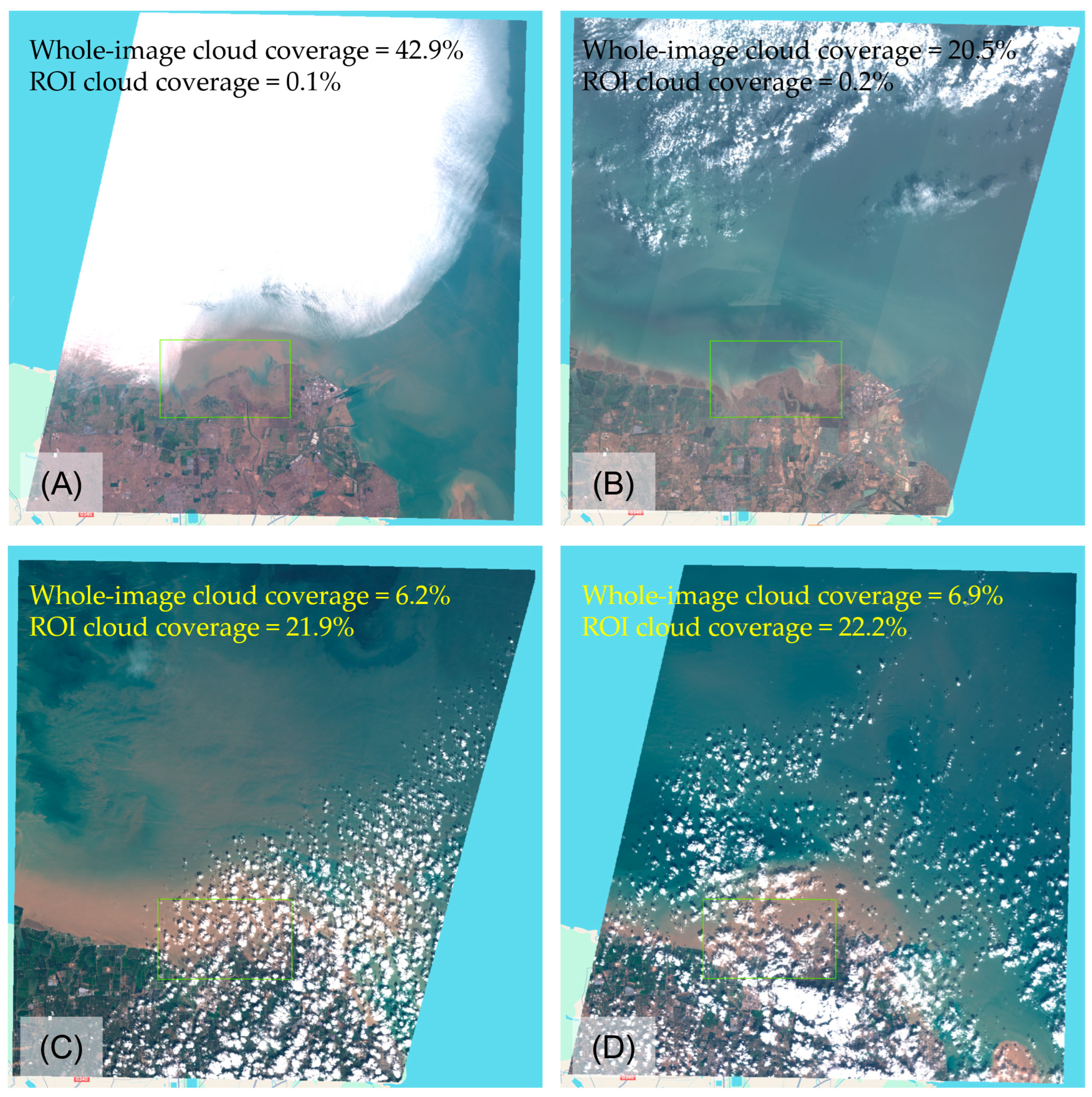
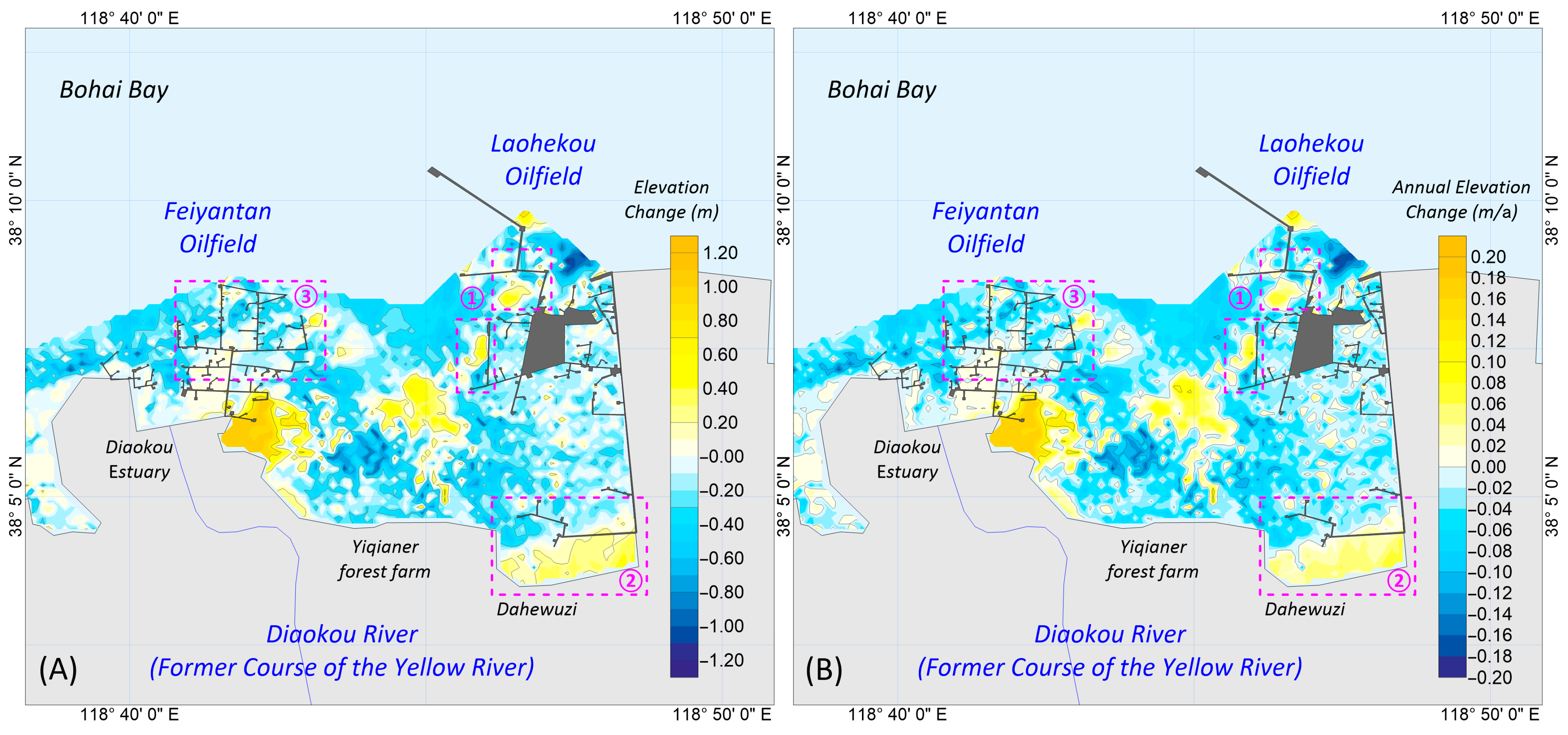
| Base Year of DEM | Date Range of Images | Number of Images | |||
|---|---|---|---|---|---|
| Original | Whole-Image Cloud Coverage < 2% | ROI Cloud Coverage < 2% | Finally Used | ||
| 2024 | June 2023~ November 2024 | 174 | 53 | 71 | 50 |
| 2018 | November 2017~ November 2018 | 103 | 46 | 39 | 39 |
Disclaimer/Publisher’s Note: The statements, opinions and data contained in all publications are solely those of the individual author(s) and contributor(s) and not of MDPI and/or the editor(s). MDPI and/or the editor(s) disclaim responsibility for any injury to people or property resulting from any ideas, methods, instructions or products referred to in the content. |
© 2025 by the authors. Licensee MDPI, Basel, Switzerland. This article is an open access article distributed under the terms and conditions of the Creative Commons Attribution (CC BY) license (https://creativecommons.org/licenses/by/4.0/).
Share and Cite
Zhang, L.; Yan, J.; Zhang, P.; Zhao, B.; Lin, X.; Wang, Q. Assessing Geomorphological Changes and Oil Extraction Impacts in Abandoned Yellow River Estuarine Tidal Flats Using Cloud Coverage in Region of Interest (CCROI) and WDM. Appl. Sci. 2025, 15, 9097. https://doi.org/10.3390/app15169097
Zhang L, Yan J, Zhang P, Zhao B, Lin X, Wang Q. Assessing Geomorphological Changes and Oil Extraction Impacts in Abandoned Yellow River Estuarine Tidal Flats Using Cloud Coverage in Region of Interest (CCROI) and WDM. Applied Sciences. 2025; 15(16):9097. https://doi.org/10.3390/app15169097
Chicago/Turabian StyleZhang, Lianjie, Jishun Yan, Pan Zhang, Bo Zhao, Xia Lin, and Quanming Wang. 2025. "Assessing Geomorphological Changes and Oil Extraction Impacts in Abandoned Yellow River Estuarine Tidal Flats Using Cloud Coverage in Region of Interest (CCROI) and WDM" Applied Sciences 15, no. 16: 9097. https://doi.org/10.3390/app15169097
APA StyleZhang, L., Yan, J., Zhang, P., Zhao, B., Lin, X., & Wang, Q. (2025). Assessing Geomorphological Changes and Oil Extraction Impacts in Abandoned Yellow River Estuarine Tidal Flats Using Cloud Coverage in Region of Interest (CCROI) and WDM. Applied Sciences, 15(16), 9097. https://doi.org/10.3390/app15169097


