1. Introduction
Soil deformations are a reflection of complex geodynamic processes that occur as a result of both natural and human activities. Especially in recent years, increasing urbanization, intensive groundwater use, mining activities, and infrastructure works have led to serious changes in soil behavior and trigger deformation types, such as collapses, slides, and settlements [
1]. On the other hand, natural phenomena, such as earthquakes, erosion due to rainfall, landslides, and tectonic movements, are also among the main sources of soil deformations [
2,
3].
Multidisciplinary approaches are needed to prevent and mitigate these deformations. Integration of geological, geophysical and geodetic monitoring methods, detailed soil characterization, and development of sustainable land use policies in risk areas are among the most common preventive strategies [
4,
5]. In addition, the utilization of technologies, such as remote sensing and InSAR (interferometric synthetic aperture radar), facilitates the precise monitoring of ground movements, thereby contributing to the mitigation of loss of life and property through the implementation of early warning systems [
6,
7].
InSAR-based methodologies, particularly the Small Baseline Subset (SBAS) and multi-track time-series analyses, have been increasingly applied to monitor and assess landslide dynamics due to their ability to detect millimeter-level surface deformations over large areas. These methods offer significant advantages in terms of temporal continuity, spatial coverage, and the ability to integrate ascending and descending orbit data for improved displacement decomposition. Recent studies have utilized SBAS–InSAR, multi-orbit fusion approaches, and AI-enhanced interferometric techniques to track pre-failure signals, to analyze post-failure behavior, and to evaluate rainfall-induced activation mechanisms. The versatility of these techniques has been demonstrated in various environments, including mountainous terrain, open-pit mines, glacial lake basins, and infrastructure corridors, highlighting their robustness under diverse geomorphological and climatic conditions [
8,
9,
10,
11,
12,
13].
The western Antalya region is highly susceptible to landslides due to its geographical and geological characteristics. The primary natural factors contributing to landslide occurrence in this area include steep topography, a complex geological structure (particularly fault zones where units, such as limestone, schist, and claystone coexist), and intense seasonal precipitation [
14]. For example, the Yesil Gol landslide, which developed on the eastern slope of the Akdag Massif in the Teke Region, was examined through detailed geomorphological analysis. It was identified as a planar sliding event that occurred along a vertical fault plane at the contact zone between limestone-conglomerate and claystone units [
15]. This finding indicates that most deep-seated landslides in the region tend to develop along weak planes between geological layers. Additionally, a temperature and precipitation graph based on data from the Antalya meteorological station was generated, revealing a correlation between periods of high rainfall and increased landslide activity, as was also discussed in [
14].
In recent years, the use of remote sensing technologies for the detection, monitoring, and mapping of landslides has become prominent in studies conducted in western Antalya. This study aims to determine the surface displacement dynamics of a reported landslide event located in the Büyükalan region of Antalya, Türkiye, through multi-temporal satellite radar interferometry (InSAR). Satellite imagery and radar interferometry provide valuable data for detecting mass movements occurring over large areas. Alptekin and Yakar (2024) [
16] employed remote sensing (RS) techniques, particularly interferometric synthetic aperture radar (InSAR), to analyze landslides in the Taurus Mountains, revealing the impacts of heavy rainfall on slope stability and mapping topographic changes.
Furthermore, national institutions such as the General Directorate of Mineral Research and Exploration (MTA) and the Disaster and Emergency Management Authority (AFAD) conduct landslide inventory studies based on aerial photographs and satellite imagery throughout Türkiye. One of the primary data sources for this study is the landslide inventory map. The landslide data used in this research were obtained from inventory maps published by MTA [
17]. Western Antalya holds a significant position within these national inventories; for instance, active and historical landslide areas in the region are clearly marked in the MTA’s landslide inventory maps. These types of maps, when integrated with up-to-date satellite data in a geographical information system (GIS) environment, allow for the development of comprehensive landslide hazard maps that can be used in land use planning and early warning systems.
It has been observed that the processing steps employed in the utilization of InSAR data for landslide studies in the current literature are largely similar. Despite the similarities in these steps, researchers have opted to utilize diverse InSAR techniques, including PSInSAR, DInSAR, and SBAS, in subsequent steps, owing to the presence of uncertainties in the results. The utilization of InSAR techniques in landslide detection and classification studies remains challenging [
18].
Although InSAR is widely used in landslide monitoring studies, conventional approaches often evaluate deformation outputs, such as LOS velocity maps from ascending and descending tracks, or vertical and horizontal components in isolation. This practice can hinder a holistic interpretation of surface displacement patterns, particularly in areas with complex ground motion. Moreover, in classification-based analyses, methodological inconsistencies or subjective interpretations may limit the accurate identification of deformation zones. Consequently, the concept of utilizing diverse InSAR-derived data, produced at a specific level, in conjunction has emerged. The objective of this study was to develop and evaluate two novel approaches that utilize multi-dimensional InSAR products to detect surface displacements.
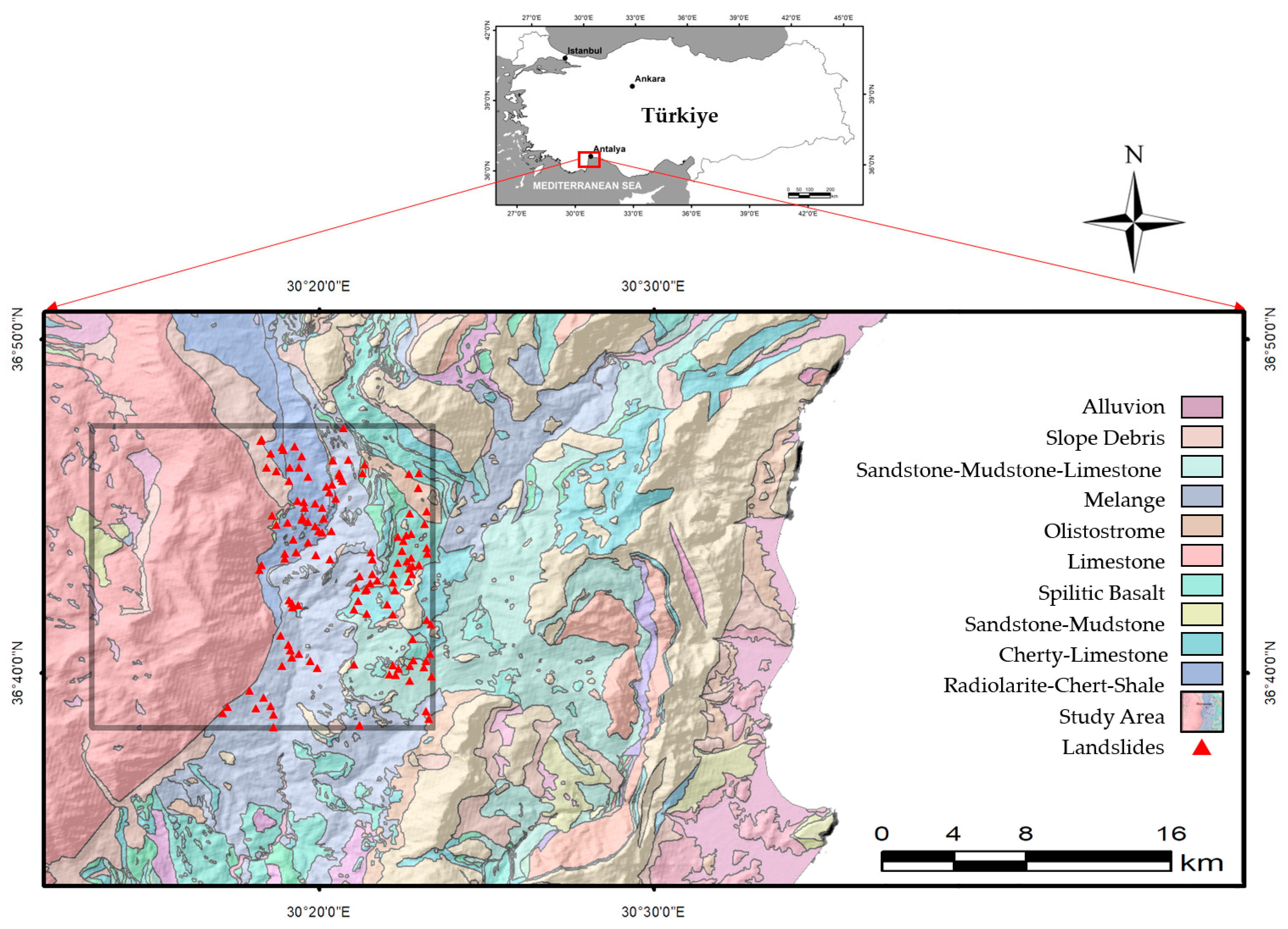
2. Study Area and Use Data Sets
The study area is located in Antalya City, which is one of the most susceptible regions in Türkiye to landslides, described as active deep-seated rotational landslides [
19,
20,
21]. The area is characterized by a combination of mountainous and semi-mountainous topography, with a Mediterranean climate that is evident in the local weather patterns.
The geological structure surrounding the Büyükalan neighborhood in Antalya is defined by the complex interaction of karstic rocks, sedimentary layers, and volcanic formations. The area is predominantly covered by Antalya tuff, a type of karstic rock that lacks a well-developed joint system, and exhibits variable porosity and mechanical behavior. This tuff plays a crucial role in determining the geotechnical properties of the region and constitutes a major component of its geological foundation [
22].
According to the 1:100,000 scale geological map [
23], the study area comprises ten different lithological units, including alluvion, slope debris, sandstone–mudstone–limestone, sandstone, mélange, olistostrome, limestone, spilitic basalt, cherty–limestone, and a complex of radiolarite–chert–shale (
Figure 1). These formations range in age from the Quaternary to the Middle Triassic (Ladinian). The dominant geological formations in the study area are Quaternary-aged slope debris, Upper Senonian-aged Kirkdirek Formation (ophiolitic mélange), Jurassic–Cretaceous-aged Dereköy Radiolarite (radiolarite–chert–shale), and Lower Cretaceous–Malm-aged Beydağları Formation (neritic limestone). The large landslide that occurred on 14 March 2017, was located within the Jurassic–Cretaceous Dereköy Radiolarite formation, characterized by chert, radiolarite, and shale lithologies.
This study was conducted in the Büyükalan region, approximately 65 km west of Antalya city center, covering a total area of 243 km
2. A total of 128 deep-seated rotational landslides were identified within the area, one of which occurred on 14 March 2017, causing significant structural damage [
24,
25,
26].
Sentinel-1 SAR Data Set and Specifications
Sentinel-1 is a pair of C-Band radar satellites (Sentinel-1A and Sentinel-1B) operated by the European Space Agency (ESA). Thanks to SAR (synthetic aperture radar) technology, the satellite can collect data day and night and in all weather conditions. This ensures that cloud cover or lack of light does not degrade data quality. Sentinel-1’s C-band sensor operates at 5.405 GHz, and provides data in both co-polarization and cross-polarization modes [
27]. This enables detailed analyses of elements, such as ground moisture, vegetation, and water surface, and interferometric applications, especially ground deformations, can be measured at the millimeter scale [
28,
29].
The utilization of the satellite pair (Sentinel-1A and Sentinel-1B) enables the revisit of the same target areas at an average interval of six days. It is evident that the frequency of revisit time offers substantial benefits in the context of monitoring dynamic processes and enhancing temporal accuracy [
30].
Sentinel-1 can collect data in different imaging modes, the most widely used of which is the Interferometric Wide Swath (IW) mode. The TOPSAR IW mode divides the radar beam into three sub-swaths (IW1, IW2, and IW3), allowing for large areas to be scanned with high phase sensitivity. This provides the detailed phase information required for the construction of interferograms. In this way, the separation of topographic effects and the correction of atmospheric delays in interferometric analyses can provide more accurate results [
31]. However, the IW mode allows for combining a large swath width (250 km) with a moderate geometric resolution (5 m by 20 m) [
32].
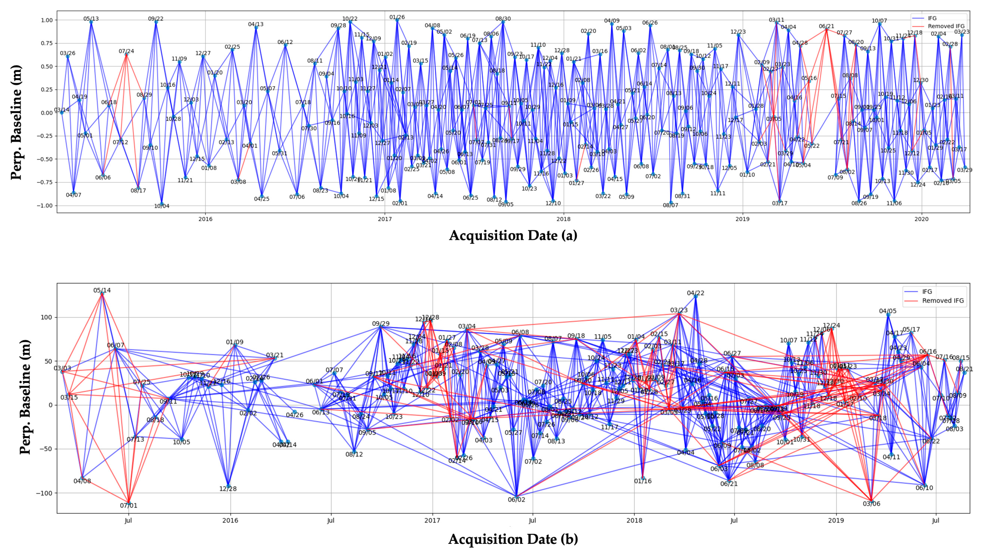
A total of 431 Single Look Complex (SLC) images acquired between 2015 and 2020 from the Sentinel-1 satellite were obtained via the LiCSAR platform, developed by COMET (Centre for the Observation and Modelling of Earthquakes, Volcanoes and Tectonics).
Table 1 presents the characteristics of the data obtained through this platform, and the parameters related to the SBAS processing steps. These images underwent preprocessing steps including thermal noise removal, radiometric calibration, orbit correction, and geometric alignment. This preprocessing phase is critical for increasing the accuracy and precision of the interferograms [
33].
Figure 2 presents the perpendicular baselines of the interferograms derived from both ascending (a) and descending (b) orbits. The interferograms generated for multi-temporal InSAR analysis were evaluated based on both temporal and geometric criteria. Interferograms with coherence values below 0.05 are highlighted in red, and were excluded from the analysis. This filtering was carried out to enhance the reliability of the results.
3. Methodology
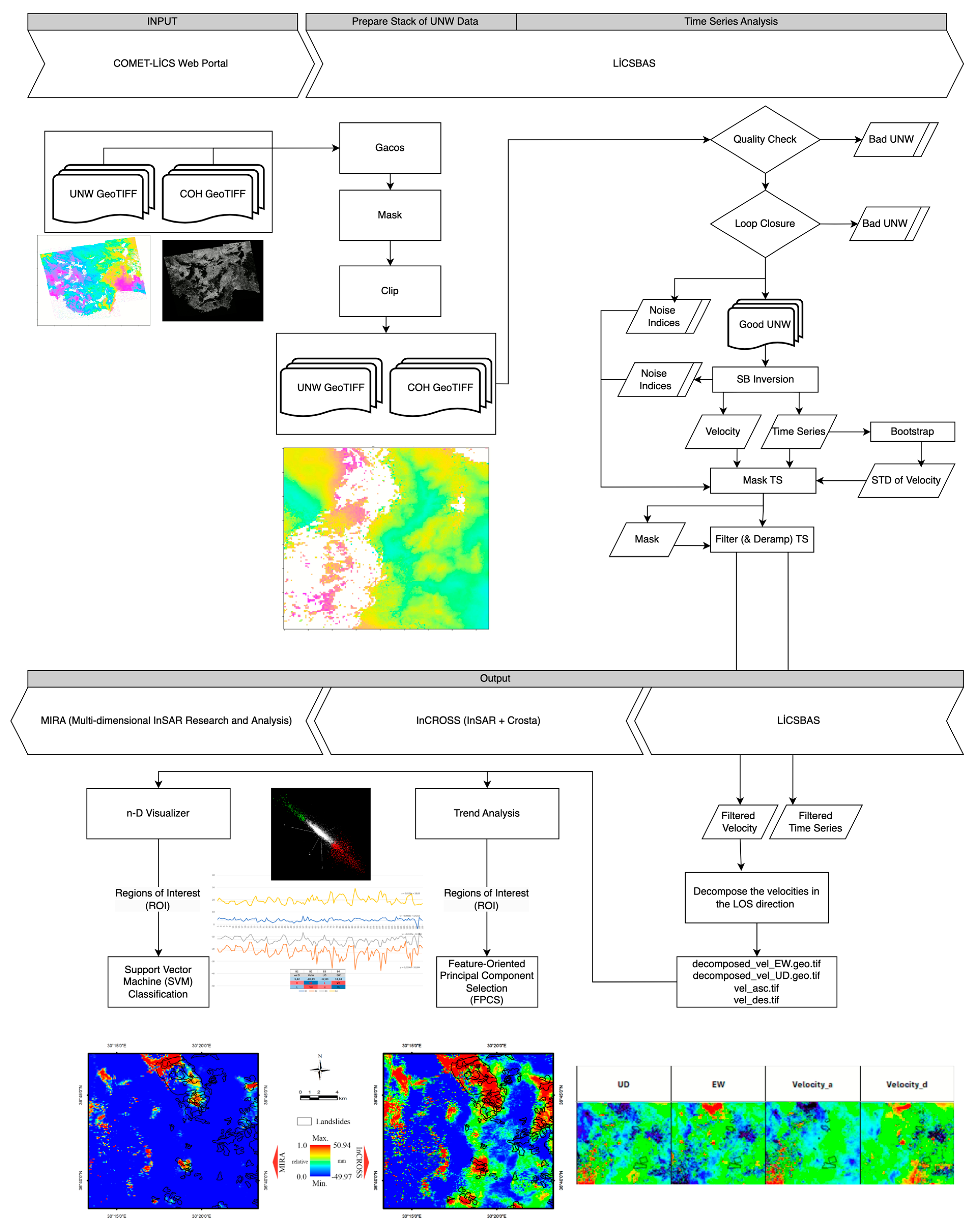
This study can be divided into the following four main steps: (1) LiCSAR processing chain; (2) time series analysis (LiCBAS); (3) obtaining InSAR outputs (deformation products); (4) application of the proposed approaches, MIRA (multi-dimensional InSAR research and analysis) and InCROSS (Crosta’s application in InSAR).
Figure 3 shows all the steps followed during this study.
The methodological framework of this study involves a sequential four-step process designed to ensure the accurate and comprehensive analysis of surface deformations in the study area. Initially, the LiCSAR processing chain was implemented to generate interferograms through procedures such as image co-registration, multilooking, and phase unwrapping. The second phase utilized the LiCSBAS2 version 1.9.1 software tools to perform a time series analysis on the unwrapped interferometric products, allowing for the detection of temporal deformation trends while minimizing atmospheric noise. In the third step, ascending and descending orbit data were decomposed into vertical and east–west components to obtain multi-directional deformation products. Finally, two advanced analytical approaches were applied as follows: MIRA used multidimensional visualization and support vector machine classification, while InCROSS employed principal component analysis and the Crosta technique to highlight and classify significant deformation zones. Detailed information about the processing steps are given in the next sections.
3.1. LiCSAR Processing Chain
LiCSAR offers a holistic processing chain that includes co-registration (alignment of images to a primary reference image), interferogram generation, multilooking, and phase unwrapping. This process enables the high resolution mapping of ground deformations over large areas [
33]. LiCSAR is an InSAR processing system tailored for Sentinel-1 data developed by the Centre for the Observation and Modelling of Earthquakes, Volcanoes and Tectonics. To support the continuous monitoring of global tectonic and volcanic activity, Sentinel-1 interferograms are routinely produced and made publicly available via the COMET-LiCS web portal [
34].
LiCSAR is a processing chain developed to automate the production of interferograms. The method consists of several steps from the original data to the derivation of the interferograms, coherence maps, and raw data. In the first step, Sentinel-1 data are acquired according to the predetermined parameters; then, the images are coordinated with each other (co-registration). For each Sentinel-1 acquisition, six interferograms are created, three with preceding scenes and three with subsequent ones. The topographic phase is removed using the Shuttle Radar Topography Mission (SRTM) digital elevation model, which has a resolution of 1 arc-second (approximately 30 m) [
35]. All generated interferograms are filtered using the Goldstein filter [
36], and are then unwrapped with the SNAPHU version 2 software [
34,
37].
LiCSAR automatically performs phase difference calculations and phase unwrapping in the interferogram generation process. This enables objective and high-resolution mapping of ground deformations over large areas. The automation suitability of LiCSAR, its reliability, and its capacity to efficiently process large data sets are also supported in the literature [
38].
3.2. Time Series Analysis (LiCSBAS)
LiCSBAS is software that performs a time series analysis on the unwrapped interferograms and coherence data produced by LiCSAR. This method is integrated with tools such as GACOS (Generic Atmospheric Correction Online Service) in order to minimize the effects of atmospheric noise and other regional factors. In the time series analysis process, the deformation values at each pixel are analyzed as a function of time, and ground deformation rates are calculated using linear regression techniques. LiCSBAS provides high-precision velocity maps to the end user by removing noisy data with spatial and temporal filtering steps. The importance of this method has been emphasized in the literature in terms of wide data coverage and accuracy [
33].
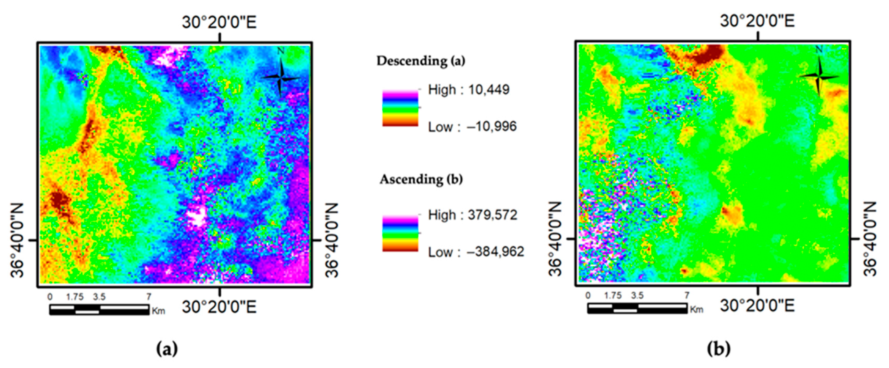
Cumulative Velocity Maps
Figure 4 displays the cumulative line-of-sight (LOS) velocity maps derived from the ascending and descending orbit data processed through the LiCSBAS workflow. Both maps represent the spatial distribution of surface displacements in the study area, expressed in millimeters per year (mm/year).
Figure 4a corresponds to the descending orbit, with deformation velocities ranging between −10.996 mm/year and +10.449 mm/year.
Figure 4b shows the results from the ascending orbit, exhibiting a wider deformation range between −38.4962 mm/year and +37.9572 mm/year. In the color scale, cooler tones (purple and blue) indicate motion toward the satellite (uplift), while warmer tones (red and orange) signify motion away from the satellite (subsidence). These maps are of critical importance for identifying and classifying mass movements, as they reflect the annual average velocity for each pixel across the region.
3.3. Obtaining InSAR Outputs (Deformation Products)
While the InSAR method can only measure surface deformations in the line-of-sight (LOS) direction, the ascending and descending orbit geometries allow for the decomposition of LOS time series into vertical and east–west (E–W) components. However, due to the near-polar orbit of satellites like Sentinel-1, the north–south (N–S) component of displacement is nearly parallel to the satellite’s azimuth direction, and contributes minimally to the LOS measurements. Therefore, the N–S deformation component cannot be reliably resolved with conventional InSAR geometry. In this study, the decomposition was carried out using the method proposed in [
39], which enables the estimation of vertical and E–W deformation time series by combining coherent data from both ascending and descending tracks. Only pixels with sufficient coherence in both acquisition geometries were selected for 3D decomposition to ensure reliability [
40,
41].
Decomposition of the LOS Velocity Maps
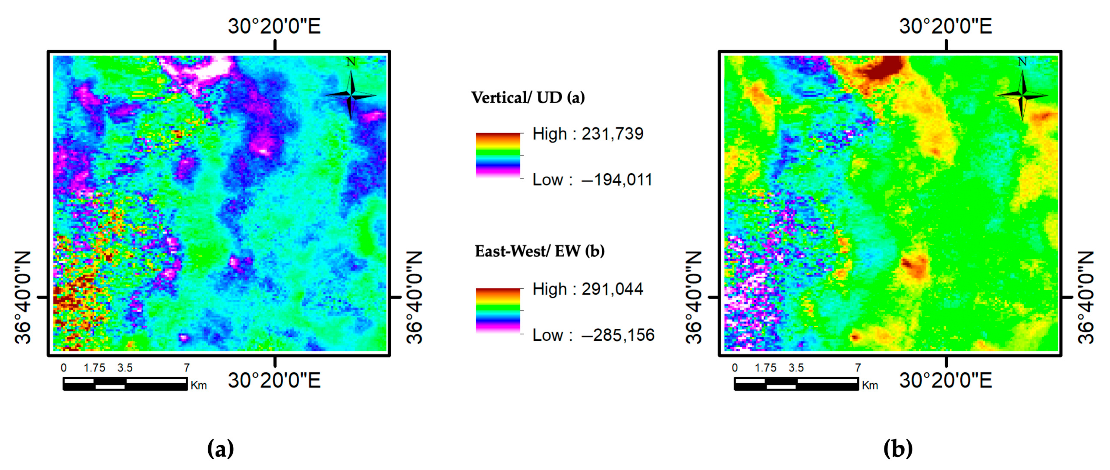
Figure 5 shows the spatial distribution of the vertical (U–D) and east–west (E–W) deformation components calculated using the results derived from the cumulative LOS velocity maps.
Figure 5a represents the vertical deformation component, with values ranging from −19.4011 mm/year to +23.1739 mm/year, while
Figure 5b displays the east–west ground motion, with velocities varying between −28.5156 mm/year and +29.1044 mm/year. The color scale in both maps enables the distinction between uplift/subsidence and eastward/westward movements. These decomposed velocity maps offer clearer insights into the directional characteristics of the surface deformation, and are particularly valuable for identifying the orientation of mass movements. The data are obtained through a joint analysis of the ascending and descending Sentinel-1 orbits, contributing to a more comprehensive three-dimensional understanding of ground displacement.
The results are visualized in the form of deformation rate maps and time series graphs. These data can be exported to GeoTIFF, KMZ, or text format and analyzed via a user-friendly interface [
38]. The primary processing steps of the LiCSAR and LiCSBAS tools are illustrated in
Figure 3.
The velocity and component maps obtained from the cumulative velocity and LOS decomposition analyses were combined with the vector-based landslide inventory data [
17] using ArcGIS 10.0 software [
42]. These datasets were exported to the GeoTIFF format and prepared as input for subsequent analysis using the MIRA and InCROSS approaches.
3.4. Implementation of the Proposed Approaches MIRA and InCROSS
Two novel approaches were proposed in this study, MIRA and InCROSS. The subsequent section will provide a comprehensive overview of these proposed approaches.
3.4.1. MIRA (Multi-Dimensional InSAR Research and Analysis)
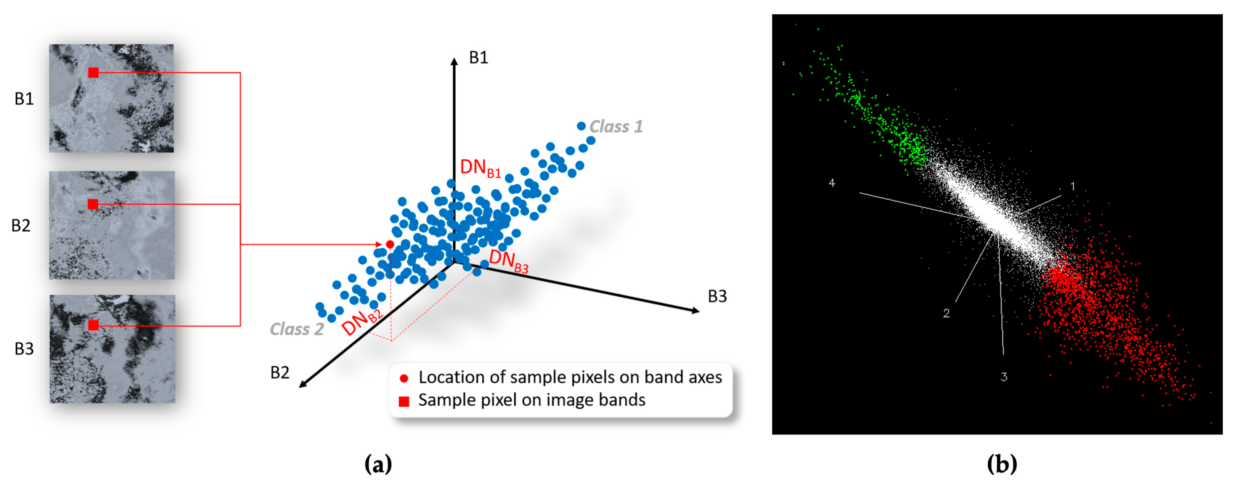
The main logic of this approach is based on the visualization of multi-dimensional data and the delineation of anomalies on multi-dimensional distribution. In this study, the descending and ascending orbit surface deformation velocity maps obtained using the LiCSBAS method, along with their decomposition into east–west (E–W) and vertical (U–D) components, and resulting in a total of four datasets, were analyzed using the n-D Visualizer module available in the ENVI 5.0 software for multidimensional visual and numerical interpretation. The n-D Visualizer is commonly used in hyperspectral and multispectral remote sensing studies, especially for identifying mineral resources and lithological units. Its interactive visualization capability allows the distribution of high-dimensional data to be explored, making it possible to distinguish between spectrally similar or distinct regions [
43,
44]. These clouds represent spectrally distinct pixel clusters within the multi-dimensional feature space created by the deformation velocity components. This approach demonstrates that different classes in n-dimensional space are grouped into clusters with different pixel values. The n-D Visualizer tool makes it easier to visualize classes that are separated from each other within the space having more than 3D axes. Clusters identified as outliers in this approach represent different classes. Although the extent to which classes cover an area seems a subjective decision, the regions in the 1/4 to 1/3 range at the outer ends of the general distribution axis (longest axis) of the point cloud with the greatest variation always indicate two separate clusters. The size of the point cloud determined for each class changes the sample size in the training class, but does not significantly change the classification result. The reason for this is that the SVM algorithm used for classification in this study has the ability to perform successful classification independently of the sample size [
45,
46]. During the analysis, 3769 points for red and 624 points for green were collected from the n-D Visualizer. The n-D visualization approach is analogous to endmember identification in hyperspectral imagery, where pixels belonging to different classes are assumed to cluster at the edges of the feature space. As illustrated in
Figure 6a, each sample pixel can be described by its digital number (DN) values across multiple bands (e.g., B1, B2, B3), and these values determine the pixel’s location in the three-dimensional feature space. In this study, a visual analysis revealed areas with different deformation characteristics, which appeared as red and green pixel clouds in the n-dimensional scatter plot (
Figure 6b). During the n-D visualization process, there is not any threshold applied to avoid any missed values.
The classification process was carried out using the ENVI-IDL-based ImageSVM tool, which allows for supervised classification based on support vector machines (SVM). The radial basis function (RBF) was selected as the kernel function due to its robust performance in nonlinear classification problems [
47,
48,
49,
50]. The RBF kernel computes the similarity between input samples using the mathematical expression shown in Equation (1).
In this formulation, the parameter g defines the width of the kernel and controls the influence of individual training samples. In this study, the gamma value (g) was set to 0.25. A higher g value can lead to overfitting, while a lower value may result in underfitting. The penalty parameter (C) was set to 100.0, which governs the trade-off between maximizing the margin and minimizing the classification error. The classification probability threshold was set to 0.01, meaning that only pixels with a predicted class probability above 1% were assigned to that class. All used SVM parameters have been generated using the parameter optimization tool from the EnMap-Box 2.2.1 tool [
51]. In this study, SVM classification using pyramid level 1was also performed, and the spatial differences were visually compared (
Figure 7). However, no significant difference was observed regarding the locations and size of the deformation (anomaly) sites. In pyramid level 0, the resolution of the original data is preserved; in pyramid level 1, analysis/classification is performed with a lower resolution version. The fact that the different pyramid level classification results obtained are not very different from each other shows that the deformation features used for classification in this study are not affected by the scale change. Another feature is that the hyper-plane model created for the SVM classification is sufficiently robust, and has enabled us to obtain similar results at both pyramid levels. In addition, the input data set was considered to have a homogeneous structure against scale change due to the lack of differences between the pyramid levels. The fact that the classification results do not change despite the differences between the pyramid levels indicates that the model is robust to scale changes, and that the features used for classification are determined from general structures. This implies that the model has good generalization ability and gives consistent results at different resolutions. As a result of these, the pyramid level is used as 0 for the SVM classification process.
The support vector machine classifier was applied to the pixel samples selected from the red and green pixel clouds in the n-dimensional scatter plot generated by the n-D Visualizer module in ENVI 5.0. The ROIs defined from these pixel clouds were used as training and test data to distinguish between different deformation characteristics. The final deformation distribution map produced by the SVM was then compared to the one obtained using the InCROSS approach to evaluate the classification performance.
3.4.2. InCROSS (Crosta Application in InSAR)
The other novel approach for analyzing InSAR is InCROSS which is based on principal component of input InSAR data sets. In the statistical evaluation of surface deformation velocity images obtained through the LiCSBAS method, principal component analysis (PCA), and the Crosta technique were employed to reveal the structural characteristics of high-dimensional data. A PCA transforms highly correlated multiband data into a set of uncorrelated new components (principal components) based on variance, thereby reducing the dimensionality of the data and enhancing dominant structural patterns [
52]. This method emphasizes the systematic variation within the deformation data while suppressing the noise components caused by irradiance effects and observation geometry. The advantage offered by PCA is particularly important in remote sensing-based surface deformation analyses, as it simplifies data statistically and enhances its interpretability. The Crosta technique, developed based on PCA, facilitates the discrimination of anomalies by emphasizing the components that exhibit specific spectral or statistical properties among the principal components [
53]. The combined application of both methods, also referred to in the literature as feature-oriented principal component selection (FPCS) or selective principal component analysis, provides effective results in identifying active deformation zones, filtering out non-systematic variations, and classifying different deformation patterns within the study area.
The landslide polygons in the existing landslide inventory (from MTA and AFAD) and the four InSAR products (i.e., the ascending and descending LOS velocities, and their decomposition into vertical (U–D) and east–west (E–W) components) were evaluated simultaneously. When the values of the pixels in landslide areas are analyzed for each InSAR product, a trend for the pixel values of InSAR products in landslide areas will be determined. Then, within the four principal components obtained by the PCA analysis using these four InSAR products as input, the principal component in which this trend is captured will correspond to the deformation areas desired (
Figure 8). For this reason, the principal component that contains all four InSAR products will cover the desired feature. In our study, it was observed that the first principal component (PC1) indicated a trend opposite to the trend observed in the landslide areas. Therefore, the opposite of this component was determined as our desired solution.
Table 2 shows the principal component and eigenvalue of four InSAR product. The trend patterns corresponding to this classification (or its inverse (low (L), very high (VH), high (H), very low (VL)) were captured through principal component analysis (PCA), as presented in
Table 2, and used to construct the dataset for this study. Blue and red color show negative and positive values, respectively, in
Table 2. Dark colors indicate larger absolute values, while light color indicate smaller absolute values.
The main logic of the InCROSS analysis is to use a directly related principal component to represent the desired trend for all combined InSAR products. Therefore, the highest values obtained in the single principal component indicate the highest amount of similarity of the desired trend.
Figure 8 shows the trend of mean values of deformation areas from original InSAR products (i.e., Band 1: Descending LOS velocities, Band 2: Ascending LOS velocities, Band 3: Vertical (U–D) deformation components, Band 4: East–West (E–W)) and derived principal components from whole data sets.
Figure 8a shows the DN values of the deformation areas, and their trends for each InSAR were plotted.
Figure 8b shows the PC1 of all products with each eigen value, and the trend of these eigen values are also plotted. Both of them have an inverse relationship, then the inverse of the PC1 were combined in to a graphical representation to show relation and correlation in
Figure 8c.
4. Results
In this study, landslide activity in the Büyükalan region of Antalya was investigated using multi-temporal InSAR analyses based on Sentinel-1 SAR data collected between 2015 and 2020. The objective was to identify the spatial and temporal characteristics of ground deformation and to analyze the directionality of surface motion. As part of the LiCSBAS processing workflow, interferograms from both the ascending and descending orbits were assessed, and those with low coherence values (coherence < 0.05) were excluded to ensure model reliability.
The cumulative LOS (line-of-sight) velocity maps derived from the ascending and descending orbits revealed distinct deformation patterns across the study area. The descending orbit results highlighted more localized zones of displacement, while the ascending data captured broader and more intense deformation trends. Deformation velocities ranged approximately between −1.1 cm/year and +1.0 cm/year for the descending data, and −3.8 cm/year and +3.8 cm/year for the ascending data. These maps visualized long-term ground motion at the pixel level, enabling the identification of uplift and subsidence areas.
To gain more detailed insight into the direction of deformation, the LOS velocities were further decomposed into vertical (up–down) and east–west components by combining the ascending and descending orbit data. The vertical component showed deformation values between approximately −1.9 cm/year and +2.3 cm/year, while the east–west component ranged from −2.8 cm/year to +2.9 cm/year. These decomposed maps provided clearer information on the directional properties of surface motion and contributed to understanding the spatial dynamics of landslide processes.
The main findings can be summarized as follows:
Low-coherence interferograms were excluded, resulting in a more reliable deformation model;
Temporal and perpendicular baseline analyses confirmed that the selected interferograms offered sufficient spatio-temporal coverage for SBAS processing;
Cumulative LOS maps revealed significant surface displacement patterns, particularly in areas with complex topography and historical landslide activity;
The decomposition of LOS data into vertical and east–west components allowed for a more accurate interpretation of the displacement directions.
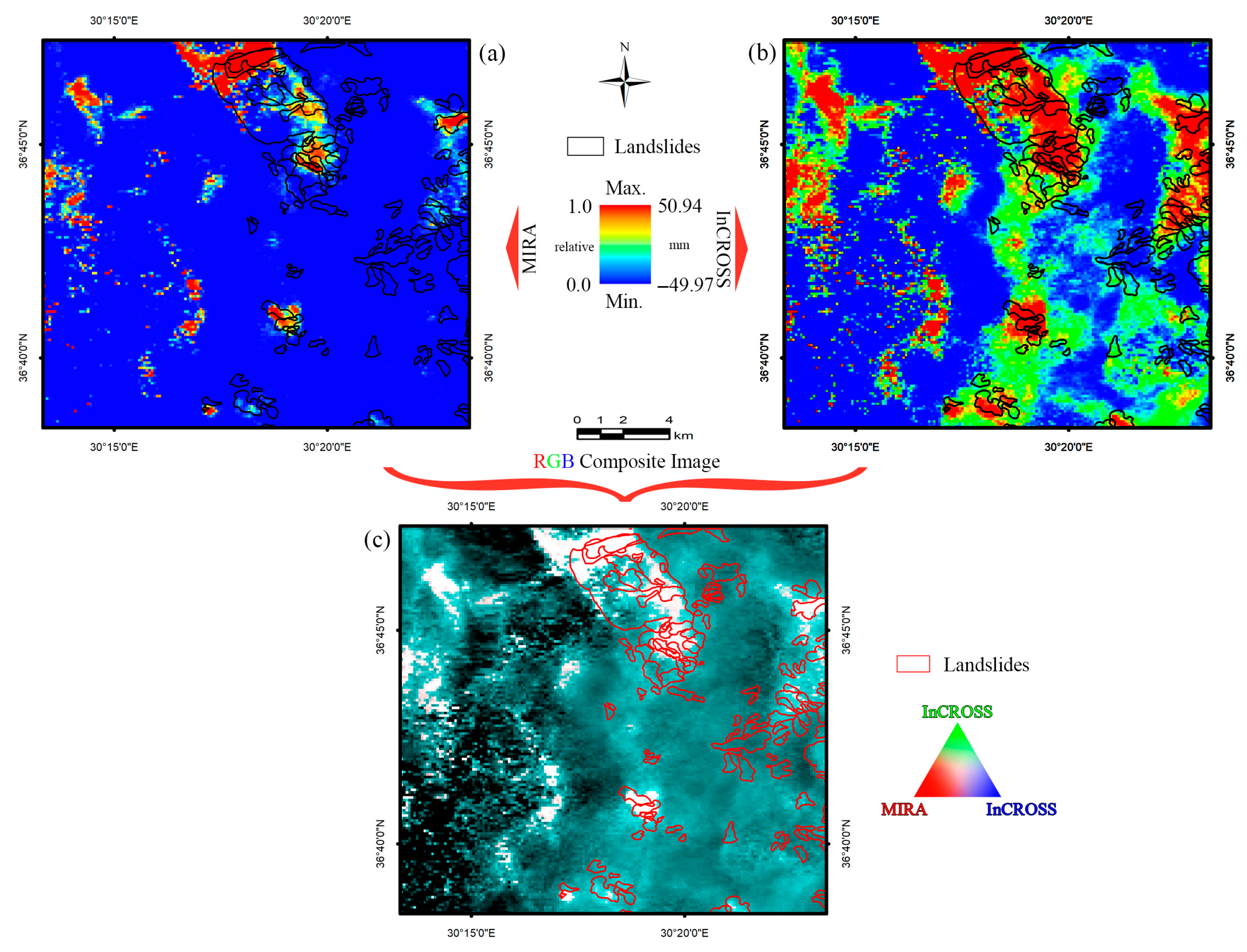
In this study, the deformation information obtained from both innovative methods was compared visually and spatially (
Figure 9). In
Figure 9a, the red areas correspond to the high deformation fields obtained using the MIRA method. Similarly, in
Figure 9b, the red areas correspond to the high deformation fields obtained using the InCROSS method. The deformation results obtained from both methods are presented as an RGB color composite in
Figure 9c. In
Figure 9c, the R component of the color composite is taken from the MIRA data, while the B–G components are taken from the InCROSS data. In the image obtained in this way, the areas with deformation in both methods are visible as bright reflection values (white). Areas not identified as deformation in either method are shown in dark (black) color. The areas shown in cyan and red colors correspond to the deformation areas identified by InCROSS and MIRA, respectively. The visual comparisons of the two methods employed in this study are illustrated in
Figure 9c. The consistency of these two methods was also computed and found to be 80.48%.
In conclusion, Sentinel-1 SAR data demonstrate strong potential for monitoring slow-moving ground deformations such as landslides. Future studies are encouraged to integrate ground-based GNSS observations to improve model accuracy. Additionally, using high-resolution DEMs and increasing SAR image acquisition frequency may enhance analysis quality, particularly in densely vegetated areas.
5. Discussion
The obtained results of this study confirm the usefulness of advanced multi-temporal InSAR techniques for detecting and characterizing ground deformations in landslide-prone areas such as western Antalya. The integration of MIRA and InCROSS approaches has enabled a detailed interpretation of deformation dynamics by combining multidimensional visualization, machine learning classification, and statistical transformation. These results are consistent with the previous studies emphasizing the importance of incorporating dimensional reduction and classification techniques to improve remote sensing analysis of landslide activity [
43,
50,
52].
The analytical process in this study has significantly benefited from the use of LiCSAR and LiCSBAS, which offer robust solutions for interferometric data processing. LiCSAR facilitates efficient interferogram generation and preprocessing through automated workflows, while LiCSBAS ensures the reliable estimation of deformation velocities based on those outputs. Thanks to their open-source nature, Python-based flexibility, and integration with modules such as atmospheric correction, these tools have been successfully applied in diverse geographic and environmental contexts [
54]. Nonetheless, challenges such as reduced data consistency in areas with dense vegetation or low backscatter require that InSAR-based interpretations be supported by ground truth validation when possible.
Among the two proposed techniques, MIRA utilizes a multidimensional data space by incorporating InSAR-derived datasets, specifically the east–west (E–W) and vertical (U–D) deformation components. The MIRA approach enables the definition of deformation models in n-dimensional distribution graphs, while also allowing for the integration of all InSAR products into the analysis using a multidimensional data cloud. Although class selection in n-dimensional space may seem subjective in the MIRA approach, this study outlines a roadmap for its selection and determination, explaining how subsequent researchers can be minimally affected by this subjectivity. The most distant members in the data cloud cluster always represent different clusters. The area covered by these clusters corresponds to approximately one-third of this long axis. However, in the MIRA approach, these training classes defined in n-dimensional space are used in the SVM classifier to perform the classification process. The SVM classifier is a non-parametric classifier, and accuracy can be obtained independently of the sample. This strong aspect of the SVM classifier stands out as a factor that increases consistency by disregarding minor differences in selection in n-dimensional space. In brief, the implementation steps of MIRA can be summarized as follows: (1) finding the longest axis of the point cloud in n-dimensional space; (2) marking as different endmembers representation the regions of 1/3 length at both ends of this selected longest axis; (3) assigning these representative clusters as training classes for the SVM. The SVM is a classifier that operates independently of the dimension of the representative cluster, so minor changes to this cluster will not alter its representativeness [
45,
46]. These steps reduce or minimize subjectivity due to the recommended standard application procedure. As a result, when combined with the motion information found in the original InSAR datasets, the multidimensional insights provided by MIRA can be very valuable in understanding deformation dynamics.
Another approach proposed in this study, InCROSS, is based on principal component analysis (PCA) and the Crosta technique, and relies on a more straightforward application principle and statistical calculations. This method benefits from prior knowledge of landslide locations and enhances structural patterns within the data, allowing for more consistent identification of the deformation zones. Notably, PCA has been demonstrated to be effective in identifying dominant patterns and temporal variations in deformation data, which has also been applied in recent research [
55].
Both proposed methods have advantages and disadvantages relative to each other. In practice, MIRA’s requirement for prior experience in processing n-dimensional datasets stands out as a disadvantage. However, since the steps to address this situation are outlined in this study, the disadvantage can be mitigated. Although the exact boundaries of the clusters may vary depending on the user, this issue is addressed by using machine learning-based SVM classification and ensuring the use of a sample size-independent classification tool.
While the application of InCROSS is easier compared to MIRA, its main disadvantage is the need for information about a known deformation area in the region. If there is no pre-existing deformation data in the region, this issue can be overcome by utilizing deformation products obtained from InSAR studies conducted in the application area.
The integrated use of both innovative methods is thought to increase the interpretability of complex InSAR data sets, and may contribute to broader applicability in various environmental conditions.
The broader implications of these findings extend to the development of integrated hazard mapping frameworks. When supported by GNSS measurements and high-resolution DEMs, such frameworks can substantially improve early warning capabilities and land-use planning. Future studies should explore the operational integration of MIRA and InCROSS into regional landslide monitoring systems and assess their performance across different climatic and geological contexts.
6. Conclusions
The aim of this study was to develop two approaches with the potential to enhance the deformation detection capability of InSAR. The integration of Sentinel-1 SAR data with advanced processing techniques, namely LiCSAR and LiCSBAS, has enabled the successful detection and analysis of multi-temporal surface deformation patterns in the Büyükalan region of western Antalya. Each of the proposed MIRA and InCROSS methods has demonstrated distinct advantages. MIRA facilitates the utilization of multiple InSAR products for the purpose of deformation analysis through multidimensional visualization. Conversely, the InCROSS technique facilitates the identification of undetected deformations within the region by employing a trend-based identification approach, utilizing known sites within the region and integrating them into a singular principal component.
In addition, not only the use of MIRA or InCROSS alone, but the use of both together will provide a very powerful tool in the identification of deformation areas. In this study, the integration of the proposed approaches, MIRA and InCROSS, proved to be effective in the comprehensive evaluation of complex deformation signals. These findings demonstrate that integrated methodologies supported by ground-based observations and high-resolution topographic data can significantly improve early warning systems and hazard mapping strategies for future applications. The approaches proposed in this study are suitable for further development and provide guidance to InSAR researchers.


