
Multi-Sensor Remote Sensing for Early Identification of Loess Landslide Hazards: A Comprehensive Approach


Abstract
1. Introduction
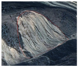
2. Study Area and Data
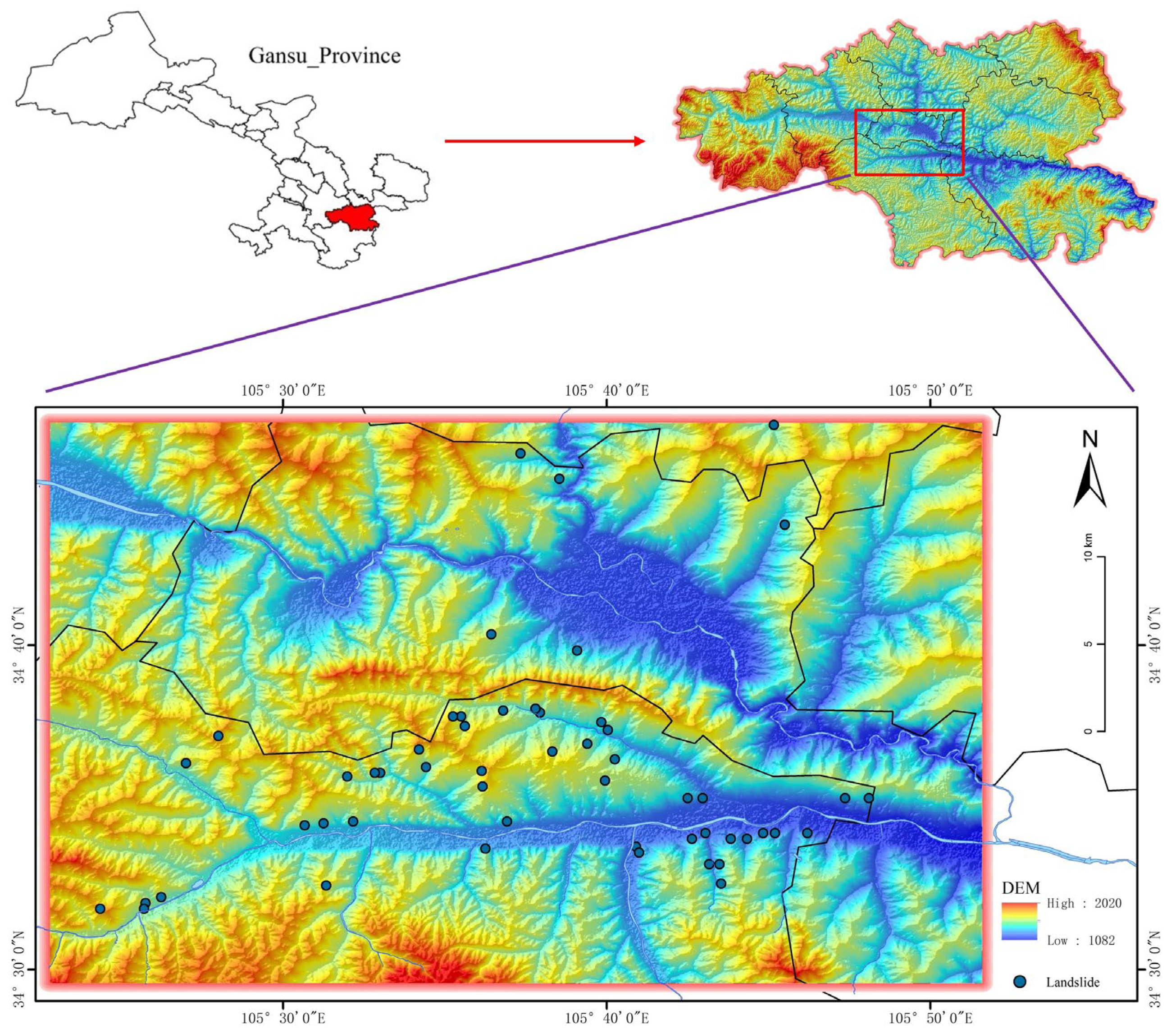
2.1. Study Area
2.2. Research Data and Processing
2.2.1. JL1KF01A Data
2.2.2. Google Earth Platform
2.2.3. Sentinel-1 Data
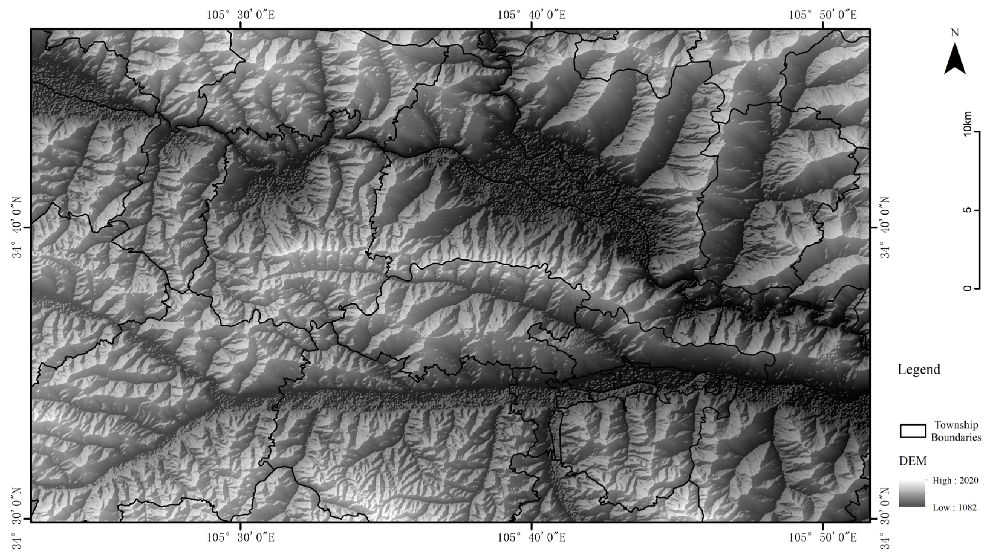
2.2.4. DEM Data
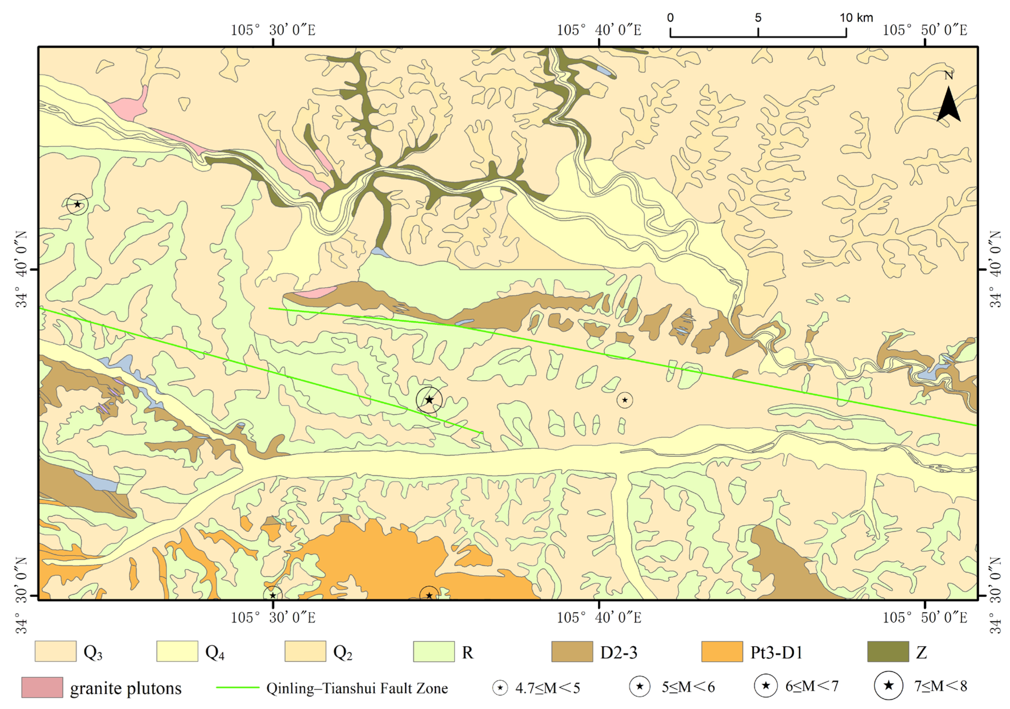
2.2.5. Geological Data
2.2.6. Landslide Inventory Data
3. Method
3.1. Research Objectives and Methodological Framework
- (1)
- Development of an integrated interpretation method and indicator library for loess landslide hazards. By examining the typical remote-sensing characteristics of loess landslide hazards, this study integrates optical remote-sensing imagery features with InSAR ground deformation monitoring results, combined with terrain characteristics such as slope gradients and proximity to rivers. This integration establishes a comprehensive interpretation framework for identifying loess landslide hazards. Additionally, an interpretation indicator library was created, clearly defining typical recognition characteristics of various landslide hazards in remote-sensing imagery and deformation data, thus providing essential technical support for subsequent interpretation tasks;
- (2)
- Implementation of ground deformation monitoring and extraction of deformation information. Using SBAS-InSAR technology, Sentinel-1 SAR imagery data from 2022 to 2023 were processed to derive regional cumulative surface deformation and deformation rate maps. These maps revealed surface displacement patterns, offering crucial evidence for the identification and evaluation of landslide hazards [27];
- (3)
- There was the comprehensive interpretation of landslide hazards to achieve preliminary identification results. Based on the developed integrated interpretation method, the ground deformation results from SBAS-InSAR and high-resolution optical remote-sensing imagery data were combined to systematically identify potential landslide hazard areas, resulting in a preliminary distribution map of landslide hazards;
- (4)
- There was the validation of identified landslide hazard points to enhance accuracy. The initially identified hazard points were imported into the Google Earth platform for visual verification and correction using high-resolution satellite imagery. The areas erroneously identified were further excluded, thereby retaining authentic and reliable hazard points. The selected typical deformation areas were analyzed in-depth to explore the evolutionary processes and spatial characteristics of landslide hazards, ultimately producing a definitive dataset of landslide hazards for the central Tianshui region;
- (5)
- There was spatial distribution analysis of landslide hazards to inform disaster prevention and mitigation strategies. Based on interpretation outcomes, spatial analytical methods were applied to statistically summarize the distribution characteristics of hazard points. The study investigates spatial associations between landslide hazards and various influencing factors, including topography, proximity to rivers, geological types, and human activity intensity. Further analyses identify mechanisms and primary controlling factors of landslide hazards, providing a scientific basis and decision-making support for landslide disaster prevention and risk management in the central Tianshui area.
3.2. SBAS-InSAR Technique
3.3. Landslide Hazard Identification Method and Construction of Interpretation Feature Library
3.3.1. Comprehensive Method for Landslide Hazard Identification
3.3.2. Comprehensive Remote-Sensing Interpretation Indicator Library
4. Result
4.1. InSAR Identification Results
4.2. Comprehensive Analysis of Remote-Sensing Interpretation Results
- (1)
- General consistency between InSAR interpretation and optical remote-sensing results
- (2)
- Partial agreement between InSAR interpretation and optical remote-sensing results
- (3)
- Landslide hazard identified solely by InSAR results
- (4)
- Summary
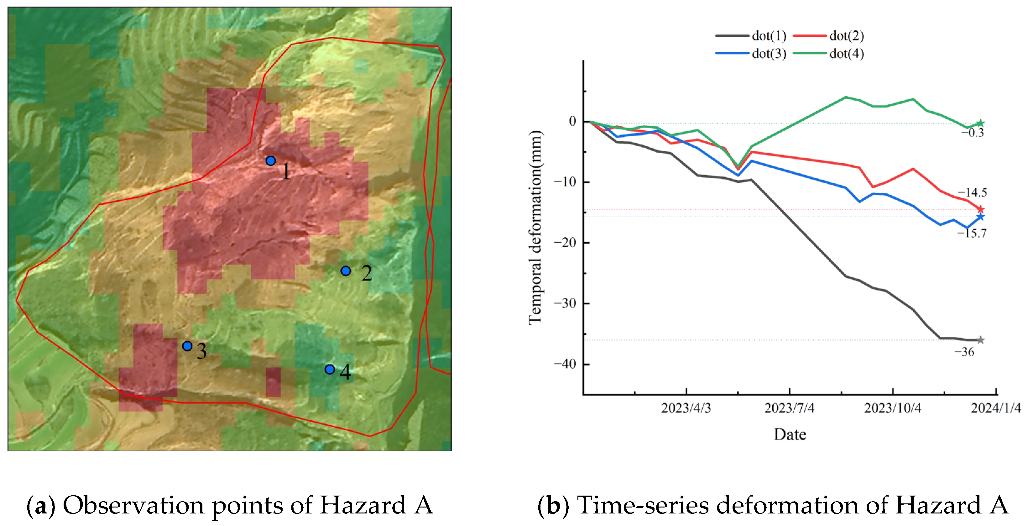
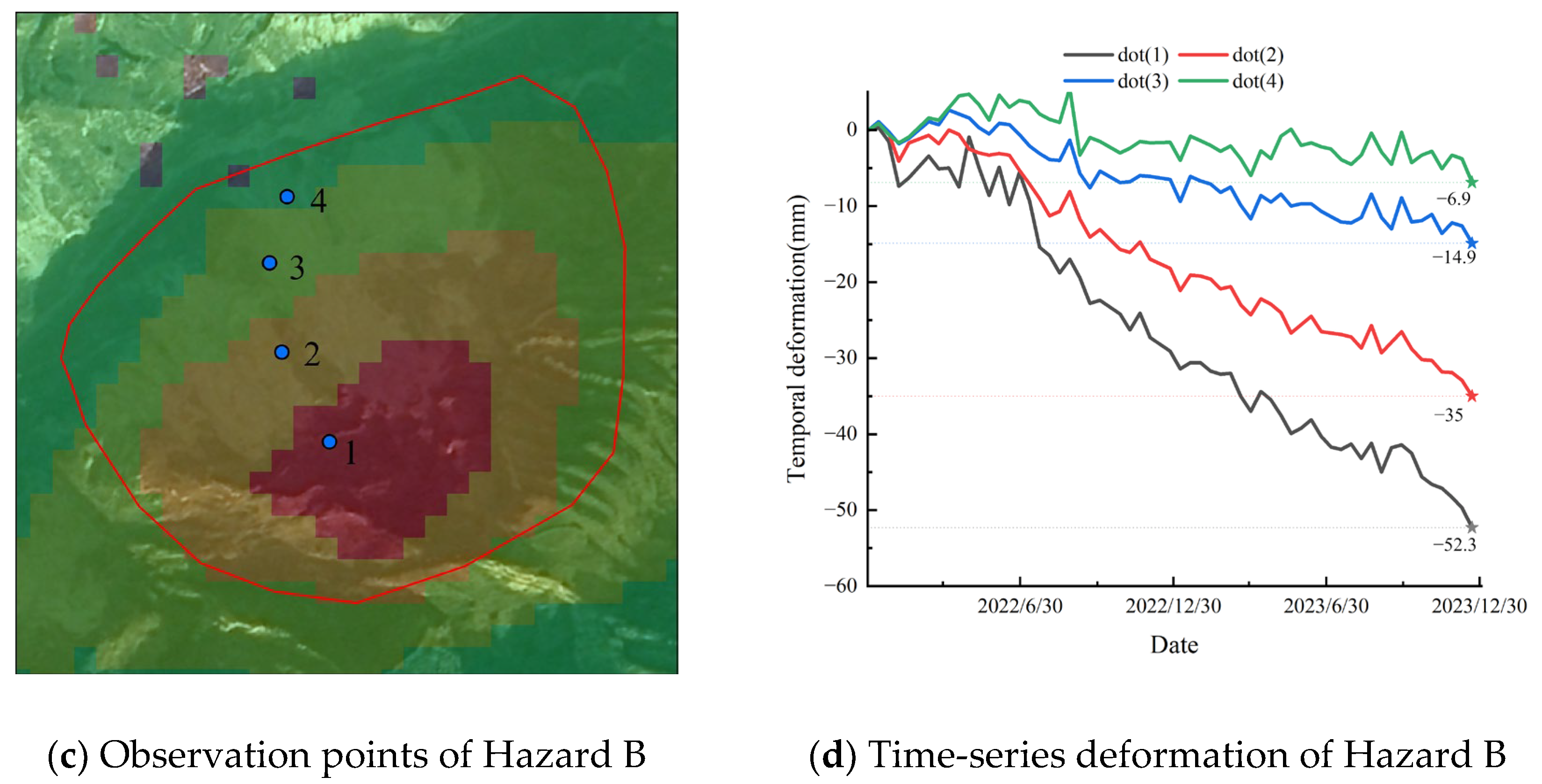
4.3. Time-Series Deformation Analysis of Typical Landslide Hazard Areas
4.4. Spatial Characteristic Analysis of Landslide Hazards
- (1)
- Influence of Slope Gradient on Landslide Hazards
- (2)
- Relationship Between Slope Aspect and Landslide Susceptibility
- (3)
- Correlation Between Landslide Hazards and River Proximity
- (4)
- Lithological Control on Landslide Hazard Distribution
5. Discussion
6. Conclusions
Author Contributions
Funding
Data Availability Statement
Conflicts of Interest
References
- Xu, Q.; Tang, M.; Xu, K.; Huang, X. Research on Space-Time Evolution Laws and Early Warning-Prediction of Landslides. Chin. J. Rock Mech. Eng. 2008, 27, 1104–1112. [Google Scholar]
- Xu, Q.; Lu, H.; Li, W.; Dong, X.; Guo, C. Types of Potential Landslide and Corresponding Identification Technologies. Geomat. Inf. Sci. Wuhan Univ. 2022, 47, 377–387. [Google Scholar] [CrossRef]
- Chen, Y.; He, X.; Xu, C.; Huang, Y.; Zhang, P.; Luo, Z.; Zhan, T. Development Characteristics and Causes of a Fatal Landslide Occurred in Shuicheng, Guizhou Province, China. ISPRS Int. J. Geo-Inf. 2022, 11, 119. [Google Scholar] [CrossRef]
- Wu, M.; Li, A.; Li, Z.; Chen, N.; Tian, S.; Hou, R.; Habumugisha, J.M.; Huang, N. Frost-Heaving May Triggered the Catastrophic Landslide in Zhenxiong on 22 January 2024. Landslides 2025, 22, 1153–1166. [Google Scholar] [CrossRef]
- Xu, Q.; Dong, X.; Li, W. Integrated Space-Air-Ground Early Detection, Monitoring and Warning System for Potential Catastrophic Geohazards. Geomat. Inf. Sci. Wuhan Univ. 2019, 44, 957–966. [Google Scholar] [CrossRef]
- Lu, Y.; Xu, H.; Wang, C.; Yan, G.; Huo, Z.; Peng, Z.; Liu, B.; Xu, C. A Novel Strategy Coupling Optimised Sampling with Heterogeneous Ensemble Machine-Learning to Predict Landslide Susceptibility. Remote Sens. 2024, 16, 3663. [Google Scholar] [CrossRef]
- Sun, Y.; Zhang, E.; Lu, H.; Wang, X.; Zhang, C. Research on “Point-Surface” Collaborative Recognition Technology of Comprehensive Remote Sensing for Hidden Landslide Hazards. Remote Sens. Nat. Resour. 2024, 34, 224–230. [Google Scholar]
- Zhang, L.; He, J.; Yang, Q.; Xiao, Y.; Yuan, Q. Data-Driven Multi-Source Remote Sensing Data Fusion: Progress and Challenges. Acta Geod. Cartogr. Sin. 2022, 51, 1317. [Google Scholar] [CrossRef]
- Jia, H.; Wang, Y.; Ge, D.; Deng, Y.; Wang, R. InSAR Study of Landslides: Early Detection, Three-Dimensional, and Long-Term Surface Displacement Estimation—A Case of Xiaojiang River Basin, China. Remote Sens. 2022, 14, 1759. [Google Scholar] [CrossRef]
- Yang, X.; Chen, D.; Dong, Y.; Xue, Y.; Qin, K. Identification of Potential Landslide in Jianzha County Based on InSAR and Deep Learning. Sci. Rep. 2024, 14, 21346. [Google Scholar] [CrossRef]
- Wu, M.; Luo, M.; Liu, S. Comprehensive Identification of Potential and Old Landslides Based on Optical Remote Sensing and InSAR Technologies: A Case Study in Northwestern Yunnan Province. Chin. J. Geol. Hazard Control 2022, 33, 84–93. [Google Scholar] [CrossRef]
- Dai, C.; Li, W.; Lu, H.; Zhang, S. Landslide Hazard Assessment Method Considering the Deformation Factor: A Case Study of Zhouqu, Gansu Province, Northwest China. Remote Sens. 2023, 15, 596. [Google Scholar] [CrossRef]
- Yao, J.; Yao, X.; Liu, X. Identification and Analysis of Active Landslide Disaster in Tianshui City Using InSAR Technology. Sci. Surv. Mapp. 2022, 47, 121–132. [Google Scholar] [CrossRef]
- Peng, J.; Wang, Q.; Zhuang, J.; Leng, Y.; Fan, Z.; Wang, S. Dynamic Formation Mechanism of Landslide Disaster on the Loess Plateau. J. Geomech. 2020, 26, 714–730. [Google Scholar] [CrossRef]
- Zhang, X.; Su, Q.; Zhao, C.; Zhu, Y.; Li, K.; Fan, J.; Bai, D. A Landslide Susceptibility Evaluation Method Using Bayesian Algorithm to Optimize XGBoost. Sci. Surv. Mapp. 2023, 48, 140–150. [Google Scholar] [CrossRef]
- Yan, T.; Zhang, J.; Zhu, Y.; Liu, H.; Zhu, H. Application of Incremental Learning in Landslide Susceptibility Assessment: A Case Study of Tianshui, Gansu Province. Geol. Bull. China 2024, 43, 630–640. [Google Scholar] [CrossRef]
- Qi, T.; Zhao, Y.; Meng, X.; Shi, W.; Qing, F.; Chen, G.; Zhang, Y.; Yue, D.; Guo, F. Distribution Modeling and Factor Correlation Analysis of Landslides in the Large Fault Zone of the Western Qinling Mountains: A Machine Learning Algorithm. Remote Sens. 2021, 13, 4990. [Google Scholar] [CrossRef]
- Tian, Y.; Yang, W.; Huang, X.; Liu, T.; Li, H.; Xiang, L.; Cheng, X. Distribution Characteristics and Inducing Factors of Loess Landslide in Maiji Mappable Unit, Tianshui. J. Geomech. 2016, 22, 25–38. [Google Scholar]
- Ling, X.; Zhu, Y.; Ming, D.; Chen, Y.; Zhang, L.; Du, T. Feature Engineering of Geohazard Susceptibility Analysis Based on the Random Forest Algorithm: Taking Tianshui City, Gansu Province, as an Example. Remote Sens. 2022, 14, 5658. [Google Scholar] [CrossRef]
- Shao, X.; Ma, S.; Xu, C.; Xu, Y. Insight into the Characteristics and Triggers of Loess Landslides during the 2013 Heavy Rainfall Event in the Tianshui Area, China. Remote Sens. 2023, 15, 4304. [Google Scholar] [CrossRef]
- Liu, X.; Zhao, C.; Zhang, Q.; Peng, J.; Zhu, W.; Lu, Z. Multi-Temporal Loess Landslide Inventory Mapping with C-, X- and L-Band SAR Datasets—A Case Study of Heifangtai Loess Landslides, China. Remote Sens. 2018, 10, 1756. [Google Scholar] [CrossRef]
- Zhang, R.; Zhao, X.; Dong, X.; Dai, K.; Deng, J.; Zhuo, G.; Yu, B.; Wu, T.; Xiang, J. Potential Landslide Identification in Baihetan Reservoir Area Based on C-/L-Band Synthetic Aperture Radar Data and Applicability Analysis. Remote Sens. 2024, 16, 1591. [Google Scholar] [CrossRef]
- Yang, Z.Y.; Han, I.Y.; Zheng, X.X.; Li, W.J.; Feng, L.; Wang, Y.; Yang, Y.P. Landslide Identification Using Remote Sensing Images and DEM Basedon Convolutional Neural Network: A Case Study of Loess Landslide. Remote Sens. Nat. Resour. 2022, 34, 224–230. [Google Scholar] [CrossRef]
- Ju, Y.; Xu, Q.; Jin, S.; Li, W.; Dong, X.; Guo, Q. Automatic Object Detection of Loess Landslide Based on Deep Learning. Geomat. Inf. Sci. Wuhan Univ. 2020, 45, 1747–1755. [Google Scholar] [CrossRef]
- Li, L.; Zhang, Y.; Hou, Y.; Han, B.; An, N.; Zhang, H.; Ma, Y. Identification and Hazard Analysis of Landslides Triggered by Earthquakes and Rainfall. Earthq. Res. Adv. 2024, 4, 100272. [Google Scholar] [CrossRef]
- Zhong, J.; Li, Q.; Zhang, J.; Luo, P.; Zhu, W. Risk Assessment of Geological Landslide Hazards Using D-InSAR and Remote Sensing. Remote Sens. 2024, 16, 345. [Google Scholar] [CrossRef]
- Zhang, J.; Zuo, X.; Zhu, D.; Li, Y.; Liu, X. Long-Term Monitoring of Landslide Activity in a Debris Flow Gully Using SBAS-InSAR: A Case Study of Shawan Gully, China. Remote Sens. 2025, 17, 1580. [Google Scholar] [CrossRef]
- Xue, Z.; Zhao, S.; Zhang, B. Study on Soil Freeze–Thaw and Surface Deformation Patterns in the Qilian Mountains Alpine Permafrost Region Using SBAS-InSAR Technique. Remote Sens. 2024, 16, 4595. [Google Scholar] [CrossRef]
- Guo, J.; Xi, W.; Yang, Z.; Shi, Z.; Huang, G.; Yang, Z.; Yang, D. Landslide Hazard Susceptibility Evaluation Based on SBAS-InSAR Technology and SSA-BP Neural Network Algorithm: A Case Study of Baihetan Reservoir Area. J. Mt. Sci. 2024, 21, 952–972. [Google Scholar] [CrossRef]
- Liu, M.; Yang, Z.; Xi, W.; Guo, J.; Yang, H. InSAR-Based Method for Deformation Monitoring of Landslide Source Area in Baihetan Reservoir, China. Front. Earth Sci. 2023, 11, 1253272. [Google Scholar] [CrossRef]
- Yang, Y.; Xu, Q.; Xie, L.; Xu, Q.; Hu, J.-C.; Chen, Q. Landslide Thickness Estimated from InSAR-Derived 2D Deformation: Application to the Xiongba Ancient Landslide, China. Remote Sens. 2024, 16, 4689. [Google Scholar] [CrossRef]
- Xu, Q.; Hu, J.; Cui, W.; Liu, S.; Hu, D.; Ning, F.; Li, M. Identification of Landslide Hazards of Beipanjiang Guangzhao Hydropower Station Based on Lutan-1 SAR Satellite. Bull. Surv. Mapp. 2025, 71–75, 132. [Google Scholar] [CrossRef]
- Shan, B.; Qi, J.; Tian, W.; Zhu, K.; Jin, T.; Yang, Q.; An, X.; Yang, G.; Hu, Q.; Cao, C. Early Identification of Geological Hazards Along the Power Transmission Line in Weinan Based on SBAS-InSAR. Appl. Sci. 2025, 15, 920. [Google Scholar] [CrossRef]
- Dai, M.; Li, H.; Long, B.; Wang, X. Quantitative Identification of Landslide Hazard in Mountainous Open-Pit Mining Areas Combined with Ascending and Descending Orbit InSAR Technology. Landslides 2024, 21, 2975–2991. [Google Scholar] [CrossRef]
- He, L.; Wu, X.; He, Z.; Xue, D.; Bai, W.; Kang, G.; Chen, X.; Zhang, Y. Landslide Identification and Deformation Monitoring Analysis in Xining City Based on the Time Series InSAR of Sentinel-1A with Ascending and Descending Orbits. Bull. Eng. Geol. Environ. 2024, 83, 255. [Google Scholar] [CrossRef]
- Wei, Z.; Li, Y.; Dong, J.; Cao, S.; Ma, W.; Wang, X.; Wang, H.; Tang, R.; Zhao, J.; Liu, X.; et al. The Identification and Influence Factor Analysis of Landslides Using SBAS-InSAR Technique: A Case Study of Hongya Village, China. Appl. Sci. 2024, 14, 8413. [Google Scholar] [CrossRef]
- Luu, C.; Ha, H.; Thong Tran, X.; Ha Vu, T.; Duy Bui, Q. Landslide Susceptibility and Building Exposure Assessment Using Machine Learning Models and Geospatial Analysis Techniques. Adv. Space Res. 2024, 74, 5489–5513. [Google Scholar] [CrossRef]


| Data Source | JL1KF01A | Sentinel-1 | |
|---|---|---|---|
| Imaging Date | 17 December 2022 | 2022–2023 | |
| Processing Level | L3D | SLC (Single Look Complex) | |
| Coverage Area | Full | Full | |
| Resolution | 0.75 m | 5 × 20 m | |
| Orbit | / | Ascending (path: 55, frame: 107) | Descending (path: 62, frame: 473; 479) |
| Number of Scenes | 4 scenes | 35 scenes | 116 scenes |
| Slope (°) | Optical Remote Sensing | Deformation Rate (mm/a) + Distance from River Channels (m) | |||||||||||
|---|---|---|---|---|---|---|---|---|---|---|---|---|---|
| 0~5 mm/a | 5~15 mm/a | 15~25 mm/a | >25 mm/a | ||||||||||
| 0~250 | 250~500 | >500 | 0~250 | 250~500 | >500 | 0~250 | 250~500 | >500 | 0~250 | 250~500 | >500 | ||
| 0~5 | Dec. | Ext. | Ext. | Ext. | Ext. | Ext. | Ext. | Ext. | Ext. | Ext. | Ext. | Ext. | Ext. |
| Indec. | / | / | / | Ext. | / | / | Ext. | Ext. | / | Ext. | Ext. | Ext. | |
| 5~15 | Dec. | Ext. | Ext. | Ext. | Ext. | Ext. | Ext. | Ext. | Ext. | Ext. | Ext. | Ext. | Ext. |
| Indec. | Ext. | / | / | Ext. | Ext. | Ext. | Ext. | Ext. | Ext. | Ext. | Ext. | Ext. | |
| 15~25 | Dec. | Ext. | Ext. | Ext. | Ext. | Ext. | Ext. | Ext. | Ext. | Ext. | Ext. | Ext. | Ext. |
| Indec. | Ext. | / | / | Ext. | Ext. | Ext. | Ext. | Ext. | Ext. | Ext. | Ext. | Ext. | |
| 25~35 | Dec. | Ext. | Ext. | Ext. | Ext. | Ext. | Ext. | Ext. | Ext. | Ext. | Ext. | Ext. | Ext. |
| Indec. | Ext. | Ext. | / | Ext. | Ext. | Ext. | Ext. | Ext. | Ext. | Ext. | Ext. | Ext. | |
| 35~45 | Dec. | Ext. | Ext. | Ext. | Ext. | Ext. | Ext. | Ext. | Ext. | Ext. | Ext. | Ext. | Ext. |
| Indec. | Ext. | Ext. | / | Ext. | Ext. | Ext. | Ext. | Ext. | Ext. | Ext. | Ext. | Ext. | |
| >45 | Dec. | Ext. | Ext. | Ext. | Ext. | Ext. | Ext. | Ext. | Ext. | Ext. | Ext. | Ext. | Ext. |
| Indec. | Ext. | Ext. | / | Ext. | Ext. | Ext. | Ext. | Ext. | Ext. | Ext. | Ext. | Ext. | |
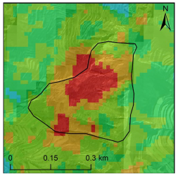
| Number | Disaster Interpretation Image | Disaster InSAR Image | Characteristics of Hidden Dangers |
|---|---|---|---|
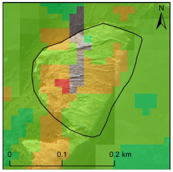
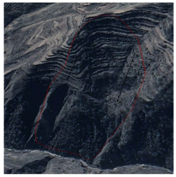
| 1 | 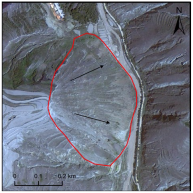 |  | Old landslide, remote-sensing imagery reveals a smooth surface devoid of vegetation and clearly defined boundaries. InSAR monitoring results indicate overall deformation across the landslide, clear and distinct side-wall features, a steep slope at the front edge, and an adjacent road. Combined with the comprehensive identification matrix, this site is identified as a landslide hazard. |
| 2 |  | 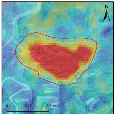 | Landslide potential, the image of the landslide surface is smooth, no vegetation cover, the boundary is clear, and there are some cracks. InSAR results show that the overall deformation of the area is large, the disaster is developed, the boundary is clear, and it is located near the river. Combined with the comprehensive identification matrix, it is judged to be a landslide hazard. |
| 3 | 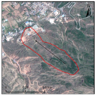 | 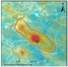 | Landslide hazard, area characterized by vegetation cover that obscures surface features shows overall deformation according to InSAR data, with greater deformation in the central region. Buildings are present at the rear edge, and the slope gradient is measured at 18.5°. Using the comprehensive identification matrix, this area is classified as a landslide hazard. |
| 4 | 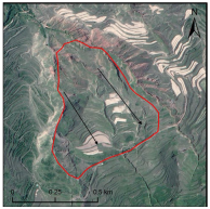 | 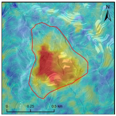 | Old landslide, clearly defined boundaries in imagery exhibits prominent landslide cracks and gullies. InSAR data reveal deformation throughout the landslide area, with significant deformation in the middle and rear sections, indicating active hazard development. This site is thus classified as a landslide hazard based on the comprehensive identification matrix. |
| 5 | 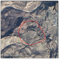 |  | Landslide hazard, area identified near a river in optical imagery exhibits evident ground cracks, gullies, and numerous adjacent remnants of old landslides. InSAR results show increasing deformation towards the riverbank, indicating clear hazard development. This area is consequently categorized as a landslide hazard using the comprehensive identification matrix. |
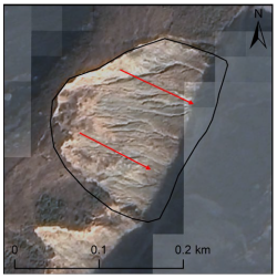
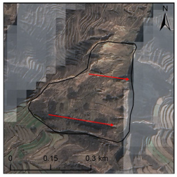
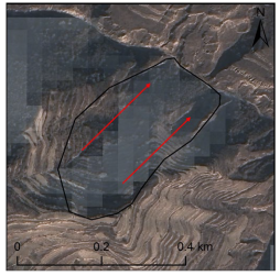
 Low deformation. In the Disaster Interpretation Image, the direction indicated by the arrow represents the sliding direction of the landslide.
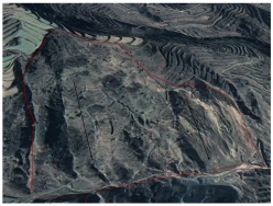
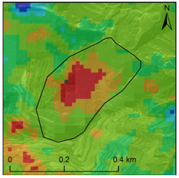
| Optical Remote-Sensing Recognition Results | InSAR Recognition Results | Google Earth Platform Verification |
|---|---|---|
 |  |  |
| (a) Optical characteristics of landslide hazard point A | (b) InSAR characteristics of landslide hazard point A | (c) Platform verification of landslide hazard point A |
 |  |  |
| (d) Optical characteristics of landslide hazard point B | (e) InSAR characteristics of landslide hazard point B | (f) Platform verification of landslide hazard point B |
 |  |  |
| (g) Optical characteristics of landslide hazard point C | (h) InSAR characteristics of landslide hazard point C | (i) Platform verification of landslide hazard point C |
| Characteristic Factor | Binned Column | Number of Landslide Hazards | Characteristic Factor | Binned Column | Number of LANDSLIDE Hazards |
|---|---|---|---|---|---|
| Slope | Aspect | North | 24 | ||
| 0~5 | 1 | Northeast | 19 | ||
| 5~15 | 55 | East | 21 | ||
| 15~25 | 52 | Southeast | 9 | ||
| 25~35 | 17 | South | 8 | ||
| 35~45 | 2 | Southwest | 4 | ||
| >45 | 0 | West | 11 | ||
| Northwest | 31 | ||||
| Distance from River Channels | 0~250 m | 19 | Distance from Fault Lines | 0–1000 m | 16 |
| 250~500 m | 23 | 1000–2000 m | 21 | ||
| >500 m | 85 | >2000 m | 90 | ||
| Lithology | Hard rcok | 2 | Deformation data (Values are absolute) | >25 mm/a | 45 |
| Weaker rock | 45 | 15~25 mm/a | 36 | ||
| Collapsible loess | 63 | 5~15 mm/a | 24 | ||
| Harder rock | 17 | 0~5 mm/a | 22 | ||
| 5–15 | 1 |
Disclaimer/Publisher’s Note: The statements, opinions and data contained in all publications are solely those of the individual author(s) and contributor(s) and not of MDPI and/or the editor(s). MDPI and/or the editor(s) disclaim responsibility for any injury to people or property resulting from any ideas, methods, instructions or products referred to in the content. |
© 2025 by the authors. Licensee MDPI, Basel, Switzerland. This article is an open access article distributed under the terms and conditions of the Creative Commons Attribution (CC BY) license (https://creativecommons.org/licenses/by/4.0/).
Share and Cite
Mao, J.; Su, Q.; Zhu, Y.; Xiao, Y.; Yan, T.; Zhang, L. Multi-Sensor Remote Sensing for Early Identification of Loess Landslide Hazards: A Comprehensive Approach. Appl. Sci. 2025, 15, 6890. https://doi.org/10.3390/app15126890
Mao J, Su Q, Zhu Y, Xiao Y, Yan T, Zhang L. Multi-Sensor Remote Sensing for Early Identification of Loess Landslide Hazards: A Comprehensive Approach. Applied Sciences. 2025; 15(12):6890. https://doi.org/10.3390/app15126890
Chicago/Turabian StyleMao, Jinyuan, Qiaomei Su, Yueqin Zhu, Yu Xiao, Tianxiao Yan, and Lei Zhang. 2025. "Multi-Sensor Remote Sensing for Early Identification of Loess Landslide Hazards: A Comprehensive Approach" Applied Sciences 15, no. 12: 6890. https://doi.org/10.3390/app15126890
APA StyleMao, J., Su, Q., Zhu, Y., Xiao, Y., Yan, T., & Zhang, L. (2025). Multi-Sensor Remote Sensing for Early Identification of Loess Landslide Hazards: A Comprehensive Approach. Applied Sciences, 15(12), 6890. https://doi.org/10.3390/app15126890