

Zoning of the Disaster-Inducing Environment and Driving Factors for Landslides, Collapses, and Debris Flows on the Qinghai–Tibet Plateau

 and
and 
Abstract
1. Introduction
2. Materials and Methods
2.1. Overview of the Study Area
2.2. Sources of Data and Preprocessing
2.3. Research Methods
2.3.1. Random Forest Model and Accuracy Metrics
2.3.2. Zoning Method
3. Results
3.1. Zonation of Hazard-Inducing Environments
3.2. Factor Contributions and Hazard-Inducing Environmental Characteristics Across Zones
3.2.1. Zonal Factor Characteristics
3.2.2. Hazard-Inducing Environment and Factor Contributions
- (1)
- Geomorphology
- (2)
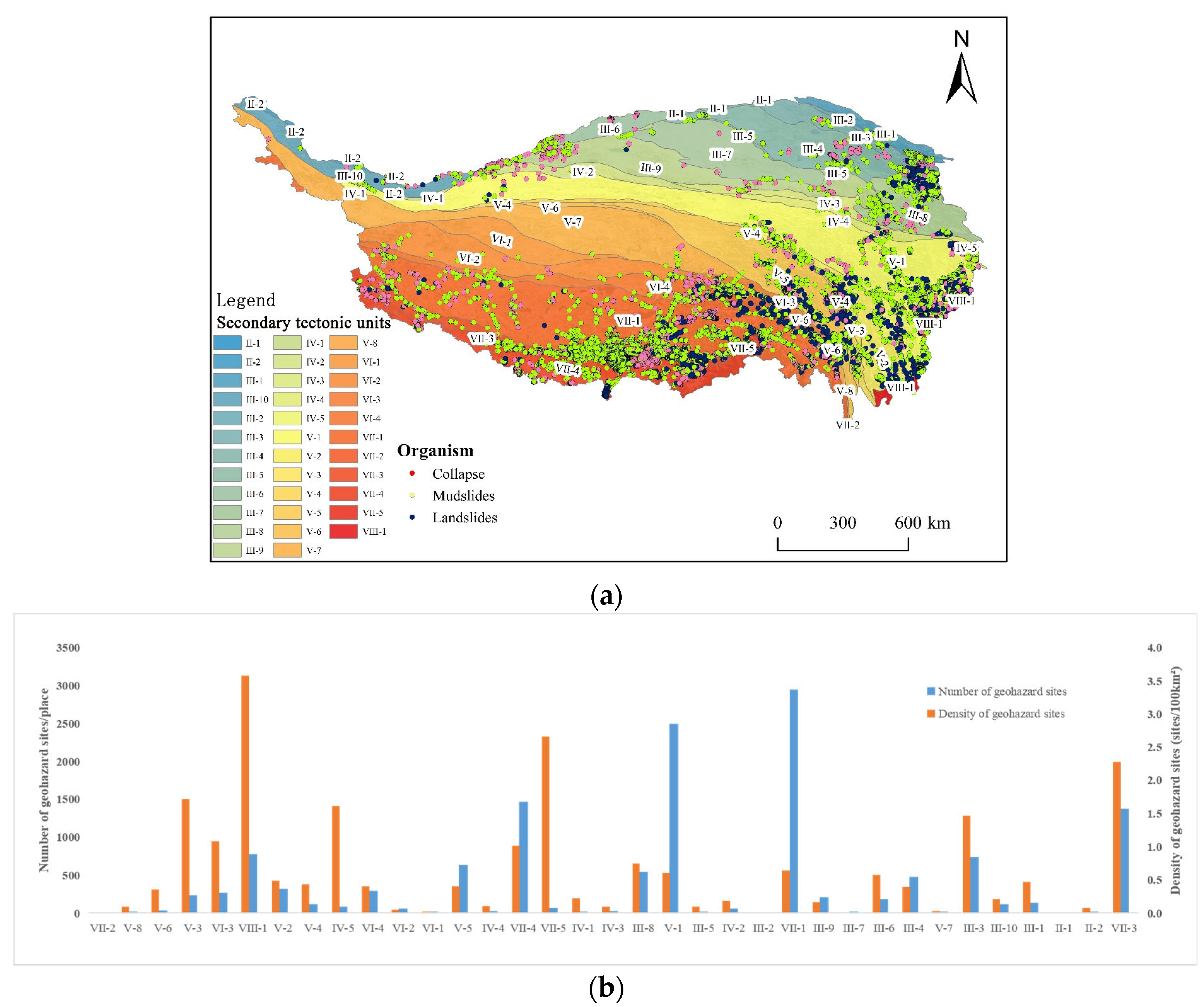
- Geological structure
- (3)
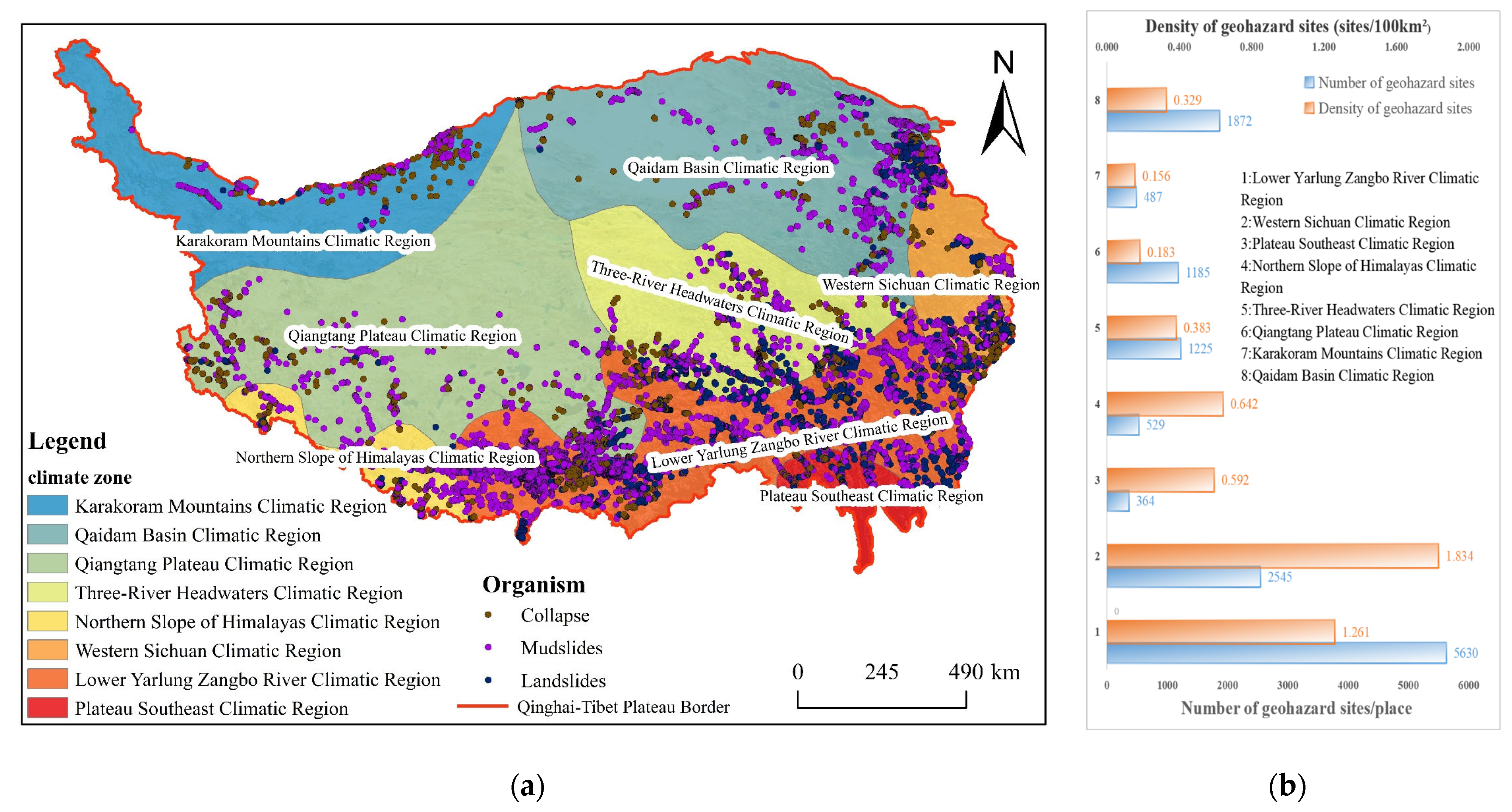
- Climate (precipitation)
- (4)
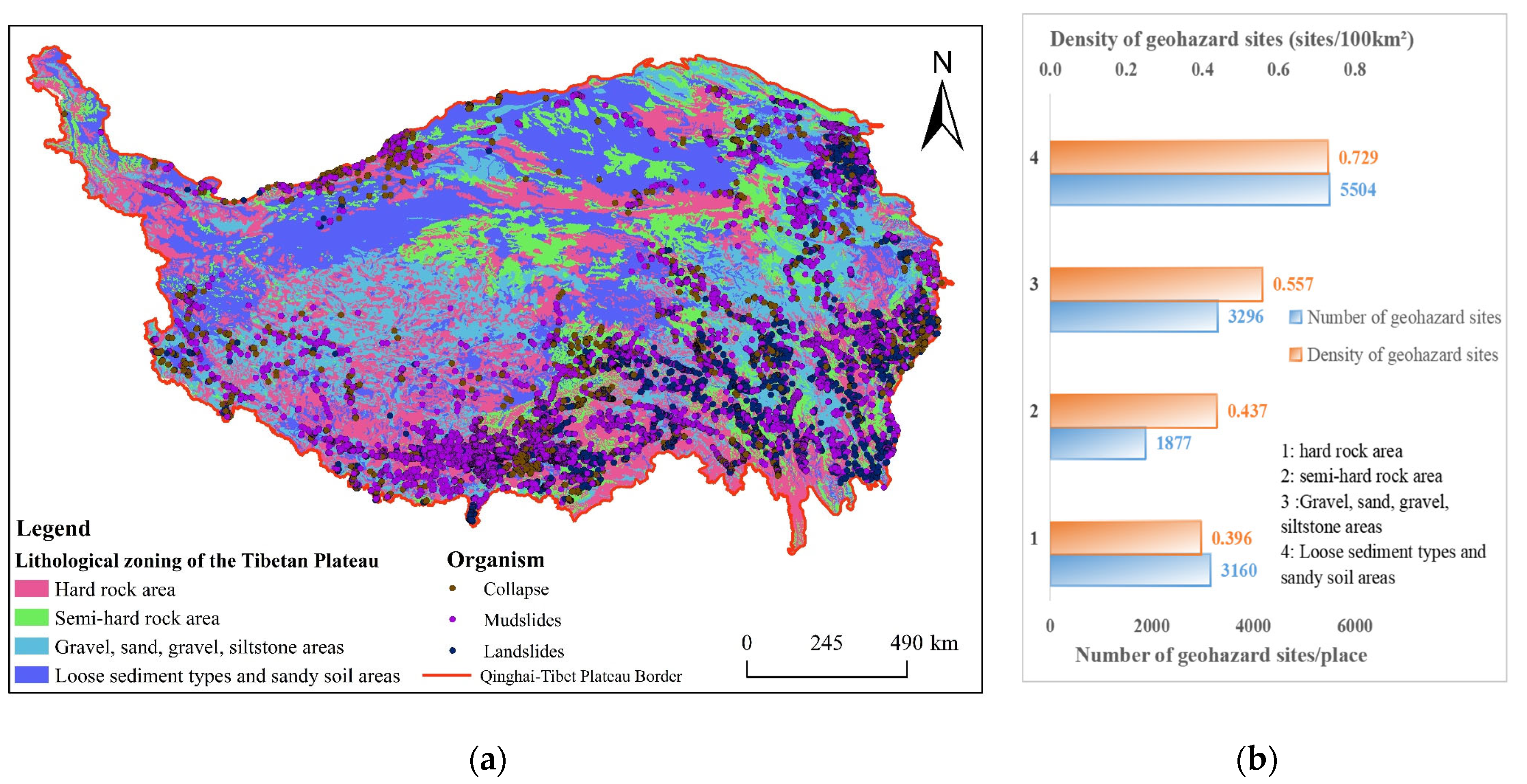
- Engineering geology
3.3. Characteristics and Causal Mechanisms of Collapse, Landslides, and Debris Flows (CLD) in Each Environmental Zone
3.3.1. Geological Disasters and Disaster-Inducing Factors
3.3.2. Analysis of Intensity and Hazard-Formation Processes
4. Discussion
4.1. Reliability Assessment of the Zoning Results
4.2. Regional Geo-Hazard Risk Mitigation Strategies
4.3. Model Accuracy Evaluation and Limitations
5. Conclusions
- (1)
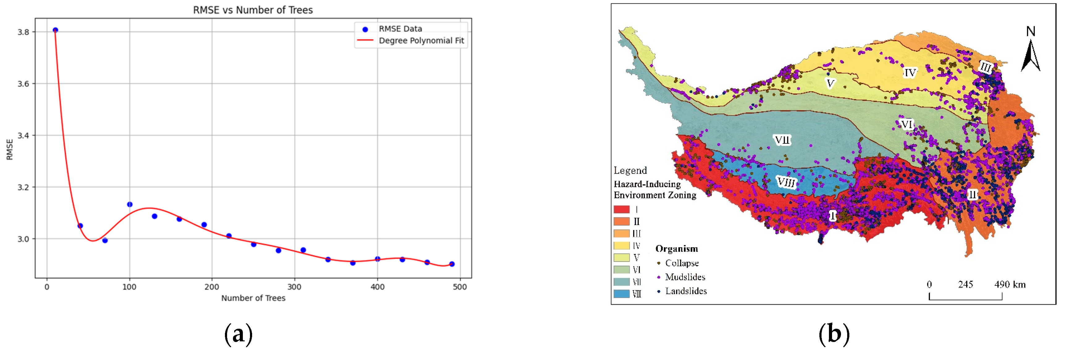
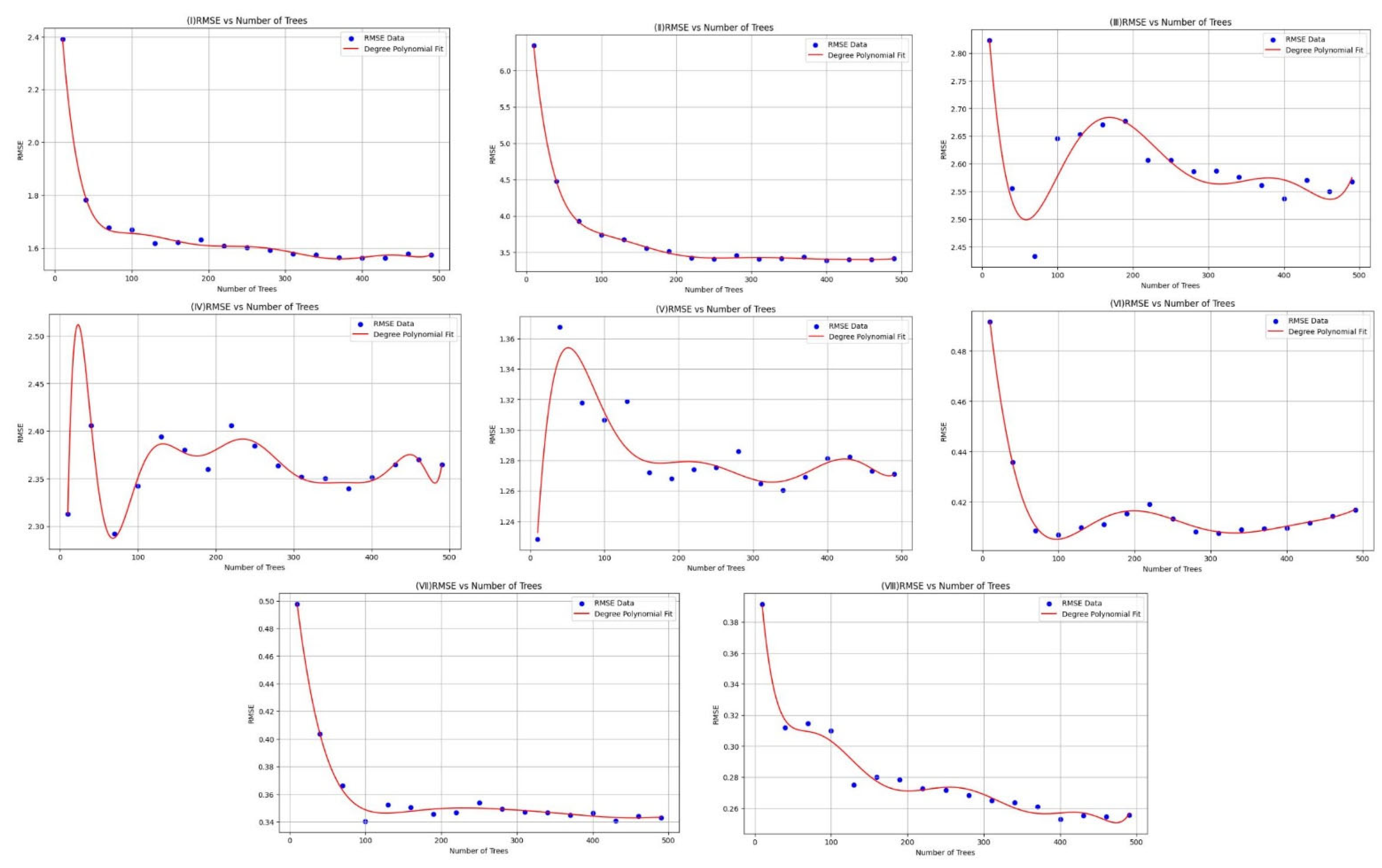
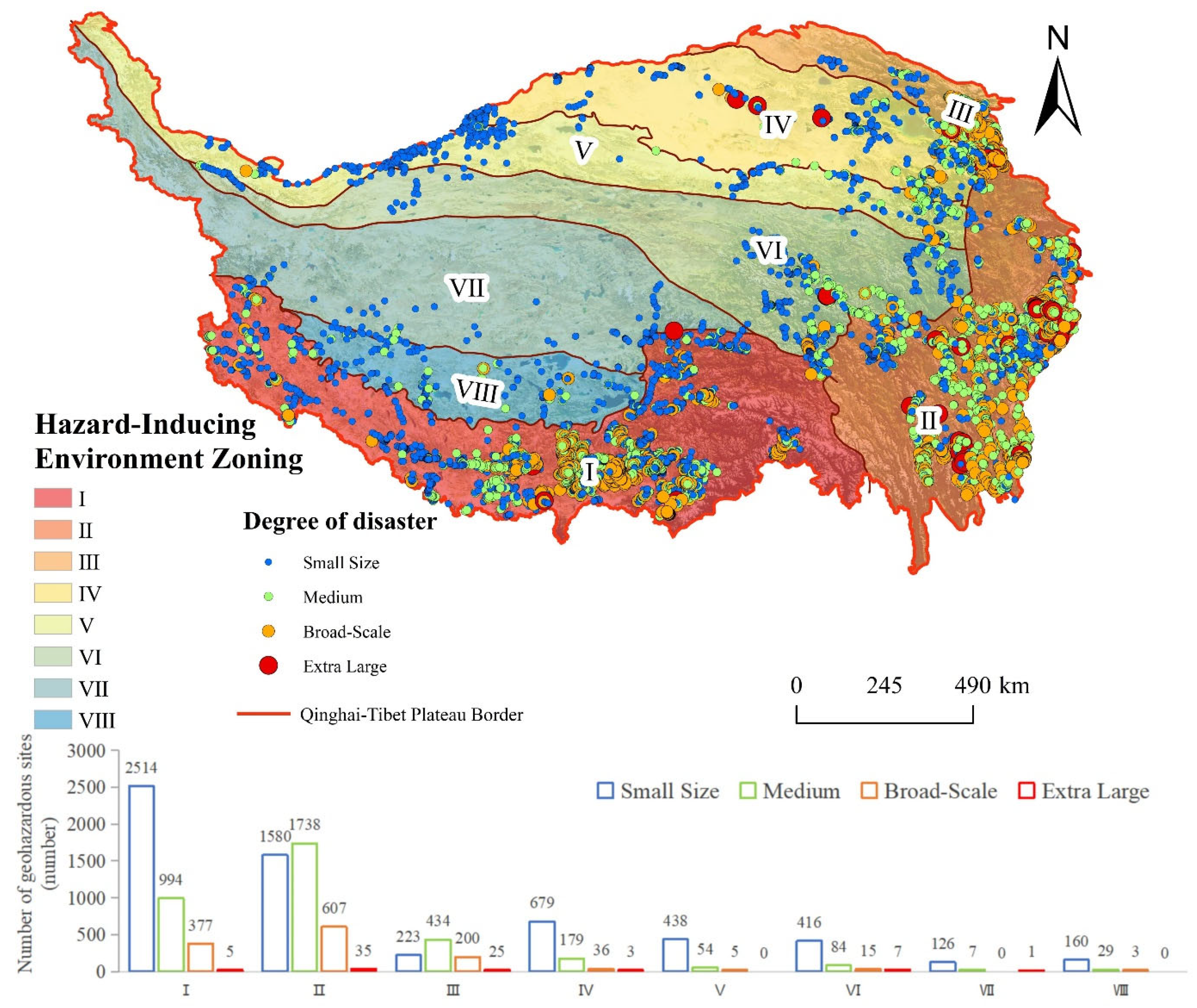
- Through the application of the Random Forest model, environmental zoning for CLD hazards across the Qinghai–Tibet Plateau was conducted. The selected models achieved high accuracy, with RMSE values all below 5 and predictive errors less than 35% of observed mean values. By calculating both overall and zonal factor weights, the Plateau was divided into eight distinct environmental zones: Zone I (Alpine Valley Freeze–Thaw Tectonic Zone), Zone II (Alpine Canyon Tectonic-Erosion Zone), Zone III (Alpine Freeze–Thaw Tectonic Active Zone), Zone IV (Faulted Basin Weathered Fragmentation Zone), Zone V (Permafrost-Weathered Rock Belt), Zone VI (Permafrost-Nival Erosion Zone), Zone VII (Alpine Hard Rock Freeze–Thaw Debris Zone), and Zone VIII (Alpine Lake Basin Saline Soft Rock Zone).
- (2)
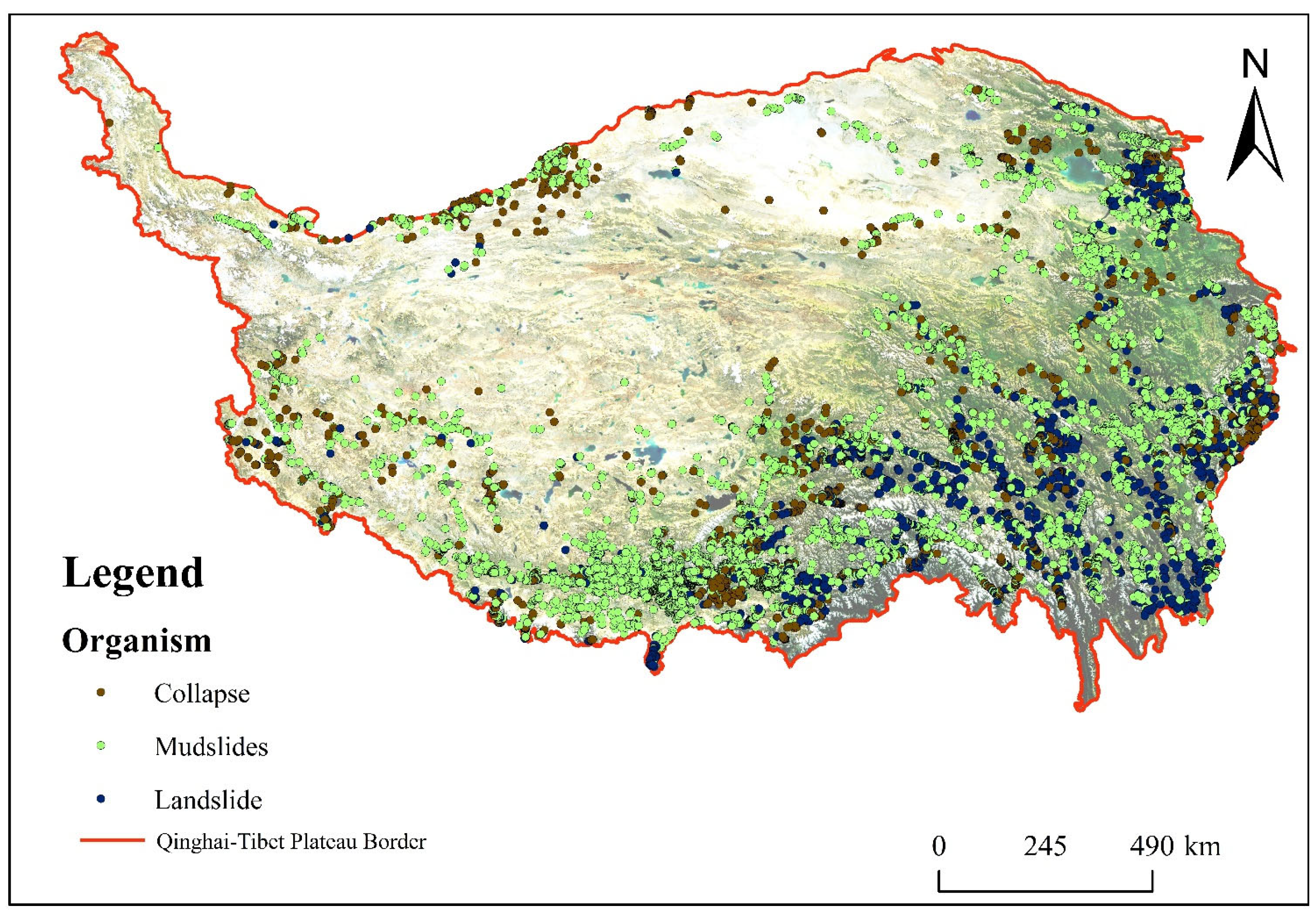
- The spatial distribution of CLD hazards on the Qinghai–Tibet Plateau exhibits strong heterogeneity, shaped by its complex geomorphology, tectonic structures, and hydrometeorological conditions. Zones I–III account for 84.32% of all recorded hazard events, with high densities ranging from 1.04 to 1.21 events per 100 km2. Specifically, Zone I features tectonic fragmentation and significant topographic relief, resulting in 910 collapse events and 3960 debris flows; Zone II is characterized by deeply incised valleys and monsoonal precipitation, leading to 1739 landslides and numerous debris flows; and Zone III is marked by moderate hazard density, primarily triggered by snowmelt and localized rainfall. By contrast, Zone IV hosts a moderate concentration of debris flows (0.30 sites/100 km2, 632 events), while Zones V–VIII, characterized by flat terrain and limited material availability, exhibit disaster densities generally below 0.30 sites/100 km2. The dominant hazard types also vary by zone: collapses are concentrated in tectonically active areas (75.65%), landslides are most prevalent in deeply incised valleys (50.38%), and debris flows dominate in regions with concentrated rainfall (53.05%), highlighting the compounded effects of geology, geomorphology, and climate.
- (3)
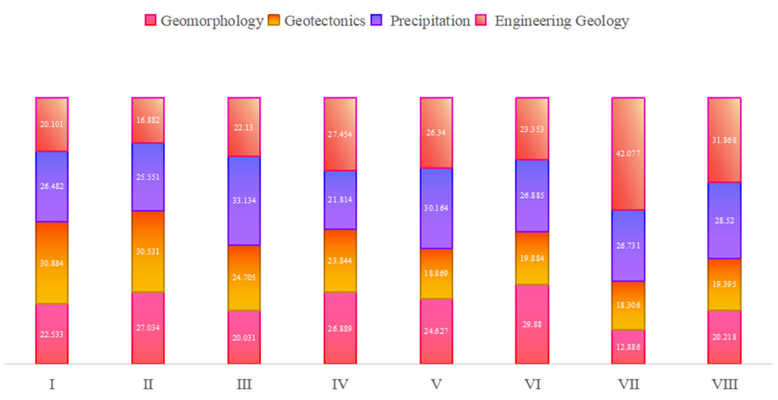
- CLD hazards are predominantly small- to medium-scale (87.99%), whereas large and extremely large events (1319 sites) are highly concentrated in Zones I–III (94.69%), with Zone II accounting for 48.67% and Zone I for 28.96%. Among moderate to large-scale events, debris flows account for the largest proportion (medium: 18.74%; large: 5.58%; extremely large: 0.51%), while collapses (15.78%) and landslides (8.73%) mainly occur at smaller scales. Hazard formation mechanisms show marked regional differentiation: Zone I is primarily driven by tectonic fragmentation (30.884%) and precipitation (26.482%); Zone II is influenced by tectonic activity (30.531%), geomorphology (27.034%), and precipitation (25.551%); Zone III is controlled by precipitation (33.134%), freeze–thaw-induced lithological degradation, and active tectonics; Zone IV is affected by weathered lithology (27.454%) and snowmelt-induced erosion; Zone V exhibits debris accumulation from freeze–thaw cycles and glacial melt erosion; and Zones VI–VIII are primarily governed by engineering geological factors (23.353–42.077%) and precipitation under low-relief terrain and limited material supply. Overall, CLD hazard formation on the Plateau follows a multifactorial coupling mechanism involving geological structure, lithology, geomorphology, and climate, where geological conditions provide the material foundation, and precipitation and terrain serve as key dynamic triggers, collectively shaping the spatial heterogeneity of CLD hazard distribution.
- (4)
- Based on the delineated zones and their dominant driving mechanisms, this study proposes differentiated regional risk management strategies. For areas with high tectonic activity, such as Zones I and II, hazard mitigation should focus on infrastructure and site selection, stability monitoring, and construction of sediment control systems. In precipitation-prone zones, early warning systems and dynamic hazard response protocols are recommended. Regions dominated by freeze–thaw and weathering processes should prioritize surface material management, ecological restoration, and stabilization of loose deposits. This approach supports a transition from general risk identification to zone-specific targeted disaster management. The proposed strategies provide both theoretical insights and practical guidance for enhancing geological hazard resilience under the complex environmental conditions of the Qinghai–Tibet Plateau.
Author Contributions
Funding
Institutional Review Board Statement
Informed Consent Statement
Data Availability Statement
Acknowledgments
Conflicts of Interest
Abbreviations
| CLD | landslides, collapses, and debris flows |
| RMSE | Root Mean Squared Error |
References
- Xiong, X.; Wang, G.; Li, Q.; Lu, Z.; Gao, R.; Feng, S.; Wu, G. Crustal Structure of the Chuan-Dian Block Revealed by Deep Seismic Sounding and its Implications for the Outward Expansion of the East Tibetan Plateau. Acta Geol. Sin. Engl. Ed. 2022, 96, 1932–1944. [Google Scholar] [CrossRef]
- Shi, P.J.; Yang, W.T. Compound effects of earthquakes and extreme weathers on geo-hazards in mountains. Clim. Change Res. 2020, 16, 405–414. [Google Scholar]
- Shi, P.J.; Lü, L.L.; Wang, M.; Wang, J.A.; Chen, W.F. Disaster system: Disaster cluster, disaster chain and disaster compound. J. Nat. Disasters 2014, 23, 1–12. [Google Scholar]
- Kuang, Z.M.; William, R.B. Dominant Control of the South Asian Monsoon by Orographic Insulation versus Plateau Heating. Nature 2010, 463, 218–222. [Google Scholar]
- Gu, F.; Li, Y.W.; Zhang, Y.; Gao, Y.; Yang, T.; Wang, A.R.; Cui, J.Y. Convection–Heat Transfer Coupling Mechanism for Closed-Loop Heat Extraction from Hydrothermal Resources Using Horizontal Wells. Coal Geol. Explor. 2024, 52, 121–130. [Google Scholar]
- Wu, Q.J.; Jiang, S.Y.; Li, C.L.; Li, H.L.; Huang, J.L. Research on Risk Zoning Evaluation of Geological Disasters in Beiliu City Based on GIS. Guizhou Geol. 2023, 40, 20–25. [Google Scholar]
- Huang, J.P.; Zhang, Z.Z. Study on Susceptibility of Mine Geological Disasters in High-Altitude Cold Mountainous Areas Based on Machine Learning. Int. J. Min. Sci. Technol. 2024, 53, 960–976. [Google Scholar]
- Yang, L.; Cervone, G. Analysis of Remote Sensing Imagery for Disaster Assessment Using Deep Learning: A Case Study of Flooding Event. Soft Comput 2019, 23, 13393–13408. [Google Scholar] [CrossRef]
- Onatayo, E. Integrating AI with Remote Sensing for Real-Time Disaster Monitoring and Rapid Response. Int. J. Res. Publ. Rev. 2025, 6, 4146–4164. [Google Scholar] [CrossRef]
- Xie, Y.L.; Qi, X.; Gao, P.; Wang, Y.H. Comparative Analysis of Slope Geological Hazard Susceptibility Assessment Based on Multiple Evaluation Models: A Case Study of Wuhan, China. South China Geol. 2025, 41, 185–196. [Google Scholar]
- Zhang, Z.Z.; Zhang, T.D.; Yu, X.K.; Lü, Q.L.; Lai, R.S.; Jia, J.Y.; Liu, X.Y. Zoning of Predisposing Environments and Formation Mechanisms of Collapse-Landslide-Debris Flow Disasters in Xinjiang. J. Eng. Geol. 2023, 31, 1129–1144. [Google Scholar]
- Wei, L.N.; Guo, Y.G. Zoning of Predisposing Environments and Formation Mechanisms of Collapse-Landslide-Debris Flow Disasters in Tibet. Tibet Sci. Technol. 2024, 46, 25–36. [Google Scholar]
- Li, Z.H.; Zhou, F.J.; Han, X.D.; Chen, J.P.; Li, Y.C.; Zhai, S.J.; Han, M.X.; Bao, Y.D. Numerical Simulation and Analysis of a Geological Disaster Chain in the Peilong Valley, SE Tibetan Plateau. Bull. Eng. Geol. Environ. 2021, 80, 3405–3422. [Google Scholar] [CrossRef]
- Shi, L.; Li, Z.; Wang, Z.; Di, S.G.; Gao, J.; Gao, X.W. Evolution of the Yigong River Channel on the Eastern Edge of the Qinghai-Tibet Plateau: Insights from Hydrodynamic Geological Hazards Shaping Topography. Eur. J. Environ. Civ. Eng. 2024, 1–15. [Google Scholar] [CrossRef]
- Guo, Y.C.; Zhang, Z.H.; Dai, F.C. Freeze-Thaw Landslide Susceptibility Assessment and Its Future Development on the Seasonally Frozen Ground of the Qinghai-Tibet Plateau under Warming-Humidifying Climate. Cold Reg. Sci. Technol. 2024, 227, 104293. [Google Scholar]
- Li, M.; Li, Q.; Xue, M. Spatio-Temporal Changes of Vegetation Net Primary Productivity and Its Driving Factors on the Tibetan Plateau from 1979 to 2018. Atmosphere 2024, 15, 579. [Google Scholar] [CrossRef]
- Lin, H.L.; Zhao, Y.T. Soil Erosion Assessment of Alpine Grassland in the Source Park of the Yellow River on the Qinghai-Tibetan Plateau, China. Front. Ecol. Evol. 2022, 9, 771439. [Google Scholar] [CrossRef]
- Duan, H.; Xue, X.; Wang, T.; Kang, W.; Liao, J.; Liu, S. Spatial and Temporal Differences in Alpine Meadow, Alpine Steppe and All Vegetation of the Qinghai-Tibetan Plateau and Their Responses to Climate Change. Remote Sens. 2021, 13, 669. [Google Scholar] [CrossRef]
- Qin, F.; Zhao, Y.; Cao, X. Biome Reconstruction on the Tibetan Plateau since the Last Glacial Maximum Using a Machine Learning Method. Sci. China Earth Sci. 2022, 65, 518–535. [Google Scholar] [CrossRef]
- Wang, N.; Cheng, W.M.; Wang, B.X.; Liu, Q.Y.; Zhou, C.H. Geomorphological Regionalization Theory System and Division Methodology of China. J. Geogr. Sci. 2020, 30, 212–232. [Google Scholar] [CrossRef]
- Liu, Y.; Ni, Z.; Zhao, Y.; Zhou, G.; Luo, Y.; Li, S.; Wang, D.; Zhang, S. Spatial-Temporal Evolution and Driving Forces of Drying Trends on the Qinghai-Tibet Plateau Based on Geomorphological Division. Int. J. Environ. Res. Public Health 2022, 19, 7909. [Google Scholar] [CrossRef]
- Pan, G.T.; Wang, L.Q.; Li, R.S. Geotectonic Map of the Qinghai-Tibet Plateau and Adjacent Areas; Geological Publishing House: Beijing, China, 2013. [Google Scholar]
- Gong, C.Q.; Dong, X.H.; Wei, C.; Ouyang, X.J.; Wu, H.Y. Precipitation Division of the Qinghai-Tibet Plateau from 1978 to 2018 and Spatiotemporal Evolution Characteristics of Each Zone. J. Water Resour. Water Eng. 2022, 33, 96–108. [Google Scholar]
- Ma, Z.; Xu, Y.; Peng, J.; Chen, Q.; Wan, D.; He, K.; Shi, Z.; Li, H. Spatial and Temporal Precipitation Patterns Characterized by TRMM TMPA over the Qinghai-Tibetan Plateau and Surroundings. Int. J. Remote Sens. 2018, 39, 3891–3907. [Google Scholar] [CrossRef]
- Zhang, Y.L.; Li, B.Y.; Zheng, D. Datasets of the Boundary and Area of the Tibetan Plateau. Acta Geogr. Sin. 2014, 69, 164–168. [Google Scholar]
- Ning, Z.; Tie, Y.; Sun, C.; Xu, W. Geohazards Susceptibility Mapping Considering Spatial Heterogeneity: A Case Study of Xide County in Sichuan Province. Nat. Hazards 2024. [Google Scholar] [CrossRef]
- Shen, Z.X.; Zhang, Q.; Wu, W.H.; Song, C.Q. Spatial Pattern and Driving Factors of Geological Disaster-Inducing Areas in the Tibetan Plateau and Hengduan Mountains. J. Geogr. Sci. 2022, 77, 1211–1224. [Google Scholar]
- Zhu, Z.; Zhang, Y. Flood Disaster Risk Assessment Based on Random Forest Algorithm. Neural Comput. Applic 2022, 34, 3443–3455. [Google Scholar] [CrossRef]
- Zhang, S.; Tan, S.; Zhou, J.; Sun, Y.G.; Ding, D.Y.; Li, J. Geological Disaster Susceptibility Evaluation of a Random-Forest-Weighted Deterministic Coefficient Model. Sustainability 2023, 15, 12691. [Google Scholar] [CrossRef]
- Breiman, L. Random Forests. Mach. Learn. 2001, 45, 5–32. [Google Scholar] [CrossRef]
- Zhang, H.P.; Singer, B.H. Recursive Partitioning and Applications. Springer Series in Statistics; Springer: New York, NY, USA, 2010; ISBN 9781441968241. [Google Scholar]
- Zhang, H.Y.; Tang, B.H. Remote Sensing Retrieval of Total Precipitable Water Under Clear-Sky Atmosphere from FY-4A AGRI Data by Combining Physical Mechanism and Random Forest Algorithm. Natl. Remote Sens. Bull. 2021, 25, 1836–1847. [Google Scholar] [CrossRef]
- Shoarian Sattari, A. Advances in Discrete Lattice Modeling of Cemented Geomaterials—Evolution and Application; Institut für Geowissenschaften, Kiel, Germany. 2024. Available online: https://nbn-resolving.org/urn:nbn:de:gbv:8:3-2024-00135-8 (accessed on 28 January 2025).
- Yuan, Y.; Ning, Z.J.; Zuo, Z.H.; Zhou, A.H.; Liu, C. Problems Related to Single Gully Debris Flow Assessment Models. Nat. Hazard 2022, 110, 1527–1544. [Google Scholar] [CrossRef]
- Xiong, X.H.; Wang, C.L.; Bai, Y.J.; Tie, Y.B.; Gao, Y.C.; Li, G.H. Comparison of Landslide Susceptibility Assessment Based on Multiple Hybrid Models at County Level: A Case Study for Puge County, Sichuan Province. Chin. J. Geohazard Control 2022, 33, 114–124. [Google Scholar]
- Alsabhan, A.H.; Sadique, M.R.; Ahmad, S.; Alam, S.; Binyahya, A.S. The Effect of Opening Shapes on the Stability of Underground Tunnels: A Finite Element Analysis. GEOMATE J. 2021, 21, 19–27. Available online: https://geomatejournal.com/geomate/article/view/1301 (accessed on 28 January 2025). [CrossRef]
- Shi, P.J. Theory and Practice on Disaster System Research in a Fifth Time. J. Nat. Disasters 2009, 18, 1–9. [Google Scholar]
- Wen, H.J.; Huang, J.H.; Yuan, X.H.; Xie, P.; Xue, J.Y. GIS-SVM Prediction of Surrounding Rock Stability in Mountain Tunnels Based on Numerical Experiments. Chin. J. Rock Mech. Eng. 2020, 39, 2920–2929. [Google Scholar]
- Liu, Y.Y.; Wei, X.L.; Chen, B.C.; Jiang, H.H.; Luo, W.G. Analysis of Geological Conditions and Influencing Factors of Geological Disasters in Yili Region, Xinjiang. World Nonferrous Met. 2020, 2, 163–165. [Google Scholar]
- Liang, S.C.; Qiao, H.; Lyu, D.; He, Q. Distribution Characteristics and Main Controlling Factors of Geological Disasters in Yili Valley. Arid Land Geogr. 2023, 46, 880–888. [Google Scholar]
- Yang, W.; Niu, R.; Si, R.; Li, J. Geological Hazard Susceptibility Analysis and Developmental Characteristics Based on Slope Unit, Using the Xinxian County, Henan Province as an Example. Sensors 2024, 24, 2457. [Google Scholar] [CrossRef]
- Li, J.; Zou, Y.; Zhang, Y.; Sun, S.; Dong, X. Risk Assessment of Snow Disasters for Animal Husbandry on the Qinghai-Tibetan Plateau and Influences of Snow Disasters on the Well-Being of Farmers and Pastoralists. Qinghai-Tibetan Plateau and Influences of Snow Disasters on the Well-Being of Farmers and Pastoralists. Remote Sens. 2022, 14, 3358. [Google Scholar] [CrossRef]
- Draebing, D. Identification of rock and fracture kinematics in high alpine rockwalls under the influence of elevation. Earth Surf. Dynam. 2021, 9, 977–994. [Google Scholar] [CrossRef]
- Zhang, B.; Zhou, W. Spatial–Temporal Characteristics of Precipitation and Its Relationship with Land Use/Cover Change on the Qinghai-Tibet Plateau, China. Land 2021, 10, 269. [Google Scholar] [CrossRef]
- Jia, Y.; Liu, J.; Guo, L.; Deng, Z.; Li, J.; Zheng, H. Locomotion of Slope Geohazards Responding to Climate Change in the Qinghai-Tibetan Plateau and Its Adjacent Regions. Sustainability 2021, 13, 10488. [Google Scholar] [CrossRef]
- Li, J.J. The Environmental Effects of the Uplift of the Qinghai-Xizang Plateau. Quat. Sci. Rev. 1991, 10, 479–483. [Google Scholar]
- Yao, T.D. A Comprehensive Study of Water-Ecosystem-Human Activities Reveals Unbalancing Asian Water Tower and Accompanying Potential Risks. Chin. Sci. Bull. 2019, 64, 2761–2762. [Google Scholar] [CrossRef]
- Ren, W.; Yao, T.D.; Xie, S.Y.; He, Y.; Ren, W. Controls on the Stable Isotopes in Precipitation and Surface Waters Across the Southeastern Tibetan Plateau. J. Hydrol. 2017, 545, 276–287. [Google Scholar] [CrossRef]
- Wang, Z.; Wu, R.; Chen, S.; Huang, G.; Liu, G.; Zhu, L.H. Influence of Western Tibetan Plateau Summer Snow Cover on East Asian Summer Rainfall. J. Geophys. Res. Atmos. 2018, 123, 2371–2386. [Google Scholar] [CrossRef]
- Bao, Z.X.; Zhang, J.Y.; Lian, Y.Q.; Wang, G.P.; Jin, J.L.; Ning, Z.R.; Zhang, J.P.; Liu, Y.L.; Wang, X.J. Changes in Headwater Streamflow from Impacts of Climate Change in the Tibetan Plateau. Engineering 2024, 34, 133–142. [Google Scholar] [CrossRef]
- Shi, Y.; Liu, S.; Shangguan, D.; Li, D.; Ye, B. Peculiar Phenomena Regarding Climatic and Glacial Variations on the Tibetan Plateau. Ann. Glaciol. 2006, 43, 106–110. [Google Scholar] [CrossRef]
- Sun, Z.Z.; Ma, W.; Zhang, S.J.; Yanhu, M.U.; Yun, H.B.; Wang, H.L. Characteristics of Thawed Interlayer and Its Effect on Embankment Settlement along the Qinghai-Tibet Railway in Permafrost Regions. J. Mt. Sci. 2018, 15, 1090–1100. [Google Scholar] [CrossRef]
- Li, Y.X.; Wang, Y.; Wang, X.; Qi, J.; Zhang, X.R.; Lin, Q.G. Risk Assessment of Glacial Debris Flow on Highway under Warming Climate: A Case Study of Tianmo Gully in the Southeastern Tibetan Plateau. Ecol. Indic. 2024, 167, 112606. [Google Scholar] [CrossRef]
- Jiang, Z.L.; Zhu, J.; Chang, M.; Tang, D.S.; Huang, X. Dynamic Evolution Characteristics of Sediment Source Quantity for Debris Flow Formation in Hongchungou, Wenchuan Earthquake Area. Mt. Res. 2014, 32, 81–88. [Google Scholar]
- Di Sipio, E.; Bertermann, D. Thermal Properties Variations in Unconsolidated Material for Very Shallow Geothermal Application (ITER Project). Int. Agrophysics 2018, 32, 149–164. [Google Scholar] [CrossRef]
- Li, Y.; Liu, X.; Rodkin, M.; Pang, Y.G. Numerical Simulation of Fault Deformation and Seismic Activity in the Southern Qinghai–Tibet Plateau. J. Seismol. 2022, 26, 1295–1308. [Google Scholar] [CrossRef]
- Xiao, Q.; Wang, S.; He, N.; Gurkalo, F. Risk Zoning Method of Potential Sudden Debris Flow Based on Deep Neural Network. Water 2024, 16, 518. [Google Scholar] [CrossRef]
- Yin, Y.P.; Li, B.; Gao, Y.; Wang, W.P.; Zhang, S.L.; Zhang, N. Geostructures, Dynamics and Risk Mitigation of High-Altitude and Long-Runout Rockslides. J. Rock Mech. Geotech. Eng. 2023, 15, 66–101. [Google Scholar] [CrossRef]
- Shahgedanova, M.; Saidaliyeva, Z.; Mussina, A.; Kapitsa, V.; Raimbekova, Z.; Donskikh, D.; Kissebayev, D.; Kasenov, M.; Petrov, M. Debris Flows in the Northern Tien Shan, Central Asia: Regional Database, Meteorological Triggers, and Trends. npj Nat. Hazard 2024, 1, 49. [Google Scholar] [CrossRef]
- Cui, P.; Guo, X.J.; Jiang, T.H.; Jin, W. Disaster Effect Induced by Asian Water Tower Change and Mitigation Strategies. Bull. Chin. Acad. Sci. 2019, 34, 1313–1321. [Google Scholar]
- Wang, H.Y.; Wu, G.P.; Chen, G.X.; Chai, J.Z.; Mao, J.; Wang, D.T. Microtremor survey-based investigation of deep geothermal- and water-controlling structures in the Salt Lake geo-thermal field, Yuncheng City, Shanxi Province, China. Geophys. Geochem. Explor. 2025, 49, 32–40. [Google Scholar]
- Chang, M.; Tang, C.; Su, Y.C.; Huang, X.C. Prediction Model for Debris Flow Hazard Zone on Alluvial Fan in Milin Section of Yarlungzangbo River, Tibet. J. Eng. Geol. 2012, 20, 0971–0978. [Google Scholar]
- Zhao, C.; Liang, J.T.; Tie, Y.B.; Ma, X.B.; Zhang, X.; Gong, L.F. Study on the Activity and Sediment Transport Characteristics of Extra-Large Giant Debris Flows in the Yarlung Zangbo River Gorge, Tibet. J. Geol. Hazards Control. 2024, 35, 45–55. [Google Scholar]
- Wei, X.; Shen, Y.J.; Ning, Y.B.; Wang, Y.; Zhan, J.W.; Li, X.T. The Formation Process, Soil-Forming Characteristics, and Landslide Disaster Mechanism of Moraine in High-Mountain Glacier Regions. J. Eng. Geol. 2024, 32, 947–962. [Google Scholar]
- Zhou, J.X.; Guan, Y.H.; Wang, Y.F.; Qin, W.; He, B.H.; Wang, K.Q.; Wu, X.Q.; Wan, L.; Ding, Y.L. Technology and demonstration of comprehensive control of soil and water loss in Southwest alpine Gorge area. Acta Ecol. Sin. 2024, 44, 7937–7943. [Google Scholar]
- Bai, Y.J.; Tie, Y.B.; Meng, M.J.; Xiong, X.H.; Gao, Y.C.; Ce, H.; Ba, R.J.; Xu, W. Characteristics and Temporal-Spatial Distribution of Geohazards in Western Sichuan. Sediment. Geol. Tethyan Geol. 2022, 42, 66–74. [Google Scholar]
- Wu, B.B.; Chang, M.; Tang, L.L.; Liu, P.Y.; Luo, C.P. Study on Surface Erosion Intensity in the Alpine Valley Area. Earth Sci. 2024, 49, 3815–3825. [Google Scholar]
- Bian, J.H.; Li, X.Z.; Hu, K.H. Study on Distribution Characteristics and Dynamic Evolution of Mountain Hazards in Hengduan Mountains Area. J. Eng. Geol. 2018, 26, 6–13. [Google Scholar]
- Wu, W.J.; Zhang, Y.L.; Yang, T.; Wang, G.Y.; Feng, L.T.; Liu, J.H. Preliminary Study on Landslide Hazards in Qilian Mountain. Gansu Geol. 2021, 30, 16–29. [Google Scholar]
- Li, Y.; Qin, X.; Jin, Z.; Liu, Y. Future Projection of Extreme Precipitation Indices over the Qilian Mountains under Global Warming. Int. J. Environ. Res. Public Health 2023, 20, 4961. [Google Scholar] [CrossRef]
- Zhao, Y.; Chen, R.; Han, C.; Wang, L. Adjustment of precipitation measurements using Total Rain weighing Sensor (TRwS) gauges in the cryospheric hydrometeorology observation (CHOICE) system of the Qilian Mountains, Northwest China. J. Arid Land 2022, 14, 310–324. [Google Scholar] [CrossRef]
- Chen, J.; Zhang, J.; Wu, T.-H.; Liu, L.; Zhang, F.-Y.; Hao, J.-M.; Huang, L.-C.; Wu, X.-D.; Wang, P.-L.; Xia, Z.-X.; et al. Elevation-dependent shift of landslide activity in mountain permafrost regions of the Qilian Mountains. Adv. Clim. Change Res. 2024, 15, 1067–1077, ISSN 1674-9278. [Google Scholar] [CrossRef]
- Sun, M.P.; Zhang, H.Y.; Gong, N.G.; Yan, L.X.; Zhao, L.L. Study on Maximum Precipitation Height Zone in Qilian Mountains Area Based on TRMM Precipitation Data. J. Nat. Resour. 2019, 34, 646–657. [Google Scholar]
- Huang, Y.; Mao, W.Q.; Wang, X.Y.; Zhang, W.Y. Temporal and Spatial Distribution of Precipitation in the Qilian Mountains and Its Surrounding Areas in Recent 39 Years. J. Arid. Meteorol. 2020, 38, 527–534. [Google Scholar]
- Zhang, H.; Gao, Y.; Shi, Y.T.; Liu, X.F.; Wang, Y.X. Tectonic stress analysis based on the crustal seismic anisotropy in the northeastern margin of Tibetan plateau. Chin. J. Geophys. 2012, 55, 95–104. [Google Scholar]
- Yang, Z.H.; Zhang, Y.S.; Guo, C.B.; Yao, X. Sensitivity Analysis on Causative Factors of Geohazards in the Eastern Margin of the Tibetan Plateau. J. Eng. Geol. 2018, 26, 673–683. [Google Scholar]
- Liu, S.; He, B.; Wang, T.; Liu, J.M.; Cao, J.W.; Wang, H.J.; Zhang, S.; Li, K.; Li, R.; Zhang, Y.J.; et al. Development Characteristics and Susceptibility Assessment of Coseismic Geological Hazards of Jishishan MS 6.2 Earthquake, Gansu Province, China. J. Geomech. 2024, 30, 314–331. [Google Scholar]
- Wang, Y.; Zheng, M.; Ling, Y.; Xiang, S.; Shao, Z.; Zhang, K.; Ke, X.; Lin, X.; Han, F.; Han, J. Quaternary integrative stratigraphy, biotas, and paleogeographical evolution of the Qinghai-Tibetan Plateau and its surrounding areas. Sci. China Earth Sci. 2024, 67, 1360–1394. [Google Scholar] [CrossRef]
- Guo, C.B.; Wu, R.A.; Zhong, N.; Yang, Z.H.; Yuan, H.; Li, C.H.; Qiu, Z.D.; Cao, S.C. Large Landslides along Active Tectonic Zones of the Eastern Tibetan Plateau: Background and Mechanism of Landslide Formation. Earth Sci. 2024, 49, 4635–4658. [Google Scholar]
- Zheng, D. Study on Typical Geological Hazards in Permafrost Regions of the Tibetan Plateau Hinterland. Ph.D. Dissertation, China University of Geosciences (Beijing), Beijing, China, 2009. [Google Scholar]
- Zhang, R.J. The Relationship Between Glacier Evolution and Geological Hazards in the Qinghai-Tibet Plateau. Remote Sens. Land Resour. 2010, 22, 54–58. [Google Scholar]
- Peng, J.B.; Zhang, Y.S.; Huang, D.; Wang, F.Y.; Wang, Z.P. Interaction Disaster Effects of the Tectonic Deformation Sphere, Rock Mass Loosening Sphere, Surface Freeze-Thaw Sphere and Engineering Disturbance Sphere on the Tibetan Plateau. Earth Sci. 2023, 48, 3099–3114. [Google Scholar]
- Chen, Z.X.; Long, S.J.; Cheng, D. Zoning of Probable Occurrence Level of Geological Disasters Based on GIS. Geol. Miner. Surv. Mapp. 2023, 6, 165–170. [Google Scholar]
- Jain, R.; Nayyar, A.; Arora, S.; Gupta, A. A Comprehensive Analysis and Prediction of Earthquake Magnitude Based on Position and Depth Parameters Using Machine and Deep Learning Models. Multimed. Tools Appl. 2021, 80, 28419–28438. [Google Scholar] [CrossRef]
- Jin, J.; Lin, H.X.; Segers, A.; Xie, Y.; Heemink, A. Machine Learning for Observation Bias Correction with Application to Dust Storm Data Assimilation. Atmos. Chem. Phys. 2019, 19, 10009–10026. [Google Scholar] [CrossRef]
- Wang, Y.; Wang, L.; Liu, S.; Liu, P.; Zhu, Z.; Zhang, W. A Comparative Study of Regional Landslide Susceptibility Mapping with Multiple Machine Learning Models. Geol. J. 2024, 59, 2383–2400. [Google Scholar] [CrossRef]
- Kong, C.; Tian, Y.; Ma, X.; Weng, Z.; Zhang, Z.; Xu, K. Landslide Susceptibility Assessment Based on Different Machine Learning Methods in Zhaoping County of Eastern Guangxi. Remote Sens. 2021, 13, 3573. [Google Scholar] [CrossRef]
- Liu, Y.; Wang, W.G. Assessing Model of Casualty Loss in Rainstorms Based on Random Forest and Its Application. Meteorol. Mon. 2020, 46, 393–402. [Google Scholar]
- Lan, X.C.; Yin, Y.S.; Tang, J.L.; Lian, Y.Y.; Zhao, F.; Wang, Y.M.; Zhang, Z.X. Evaluation of Surface Latent Heat and Sensible Heat Fluxes from ERA-5, GLDAS, and MODIS on Different Underlying Surfaces in the Tibetan Plateau. J. Mt. Sci. 2025, 22, 230–245. [Google Scholar] [CrossRef]
- Hastie, T.; Tibshirani, R.; Friedman, J. The Elements of Statistical Learning: Data Mining, Inference, and Prediction, 2nd ed.; Springer: Berlin, Germany, 2009. [Google Scholar]


| No | Hazard-Inducing Factors and Disaster Points | Data Sources |
|---|---|---|
| 1 | Topography and Geomorphology | Based on the landform classification system of DEM [20,21]. |
| 2 | Geological Structures | Geotectonic map of the Qinghai–Tibet Plateau and its adjacent areas [22]. |
| 3 | Stratigraphic Lithology | Derived from ISRIC Report (2008.06). https://www.isric.org/taxonomy/term/71 (accessed on 28 September 2024) |
| 4 | Precipitation Zoning | Precipitation zoning in the Qinghai–Tibet Plateau (1978–2018) and spatiotemporal evolution characteristics [23,24]. |
| 5 | Disaster Points | Resources and Environment Science Data Center, Chinese Academy of Sciences. https://www.resdc.cn/ (accessed on 25 September 2024) |
| 6 | Study Area | Boundary of the Qinghai–Tibet Plateau. https://www.geodoi.ac.cn/ (accessed on 25 September 2024) |
| Zoning of Disaster-Inducing Environments | Area/km2 | Collapse | Landslide | Debris Flow | Small Plan (One) | Density/Place × (100 km)−2 | Percentage/% |
|---|---|---|---|---|---|---|---|
| Alpine Valley Freeze–Thaw Tectonic Zone (I) | 532,429 | 910 | 1012 | 3960 | 5882 | 1.1 | 42.51 |
| Alpine Canyon Tectonic-Erosion Zone (II) | 396,643 | 963 | 1739 | 2105 | 4807 | 1.21 | 34.74 |
| Alpine Freeze–Thaw Tectonic Active Zone (III) | 85,036 | 168 | 334 | 380 | 882 | 1.04 | 6.37 |
| Faulted Basin Weathered Fragmentation Zone (IV) | 303,823 | 180 | 89 | 632 | 901 | 0.3 | 6.51 |
| Permafrost-Weathered Rock Belt (V) | 254,436 | 255 | 34 | 213 | 502 | 0.2 | 3.63 |
| Permafrost-Nival Erosion Zone (VI) | 394,924 | 124 | 58 | 343 | 525 | 0.13 | 3.79 |
| Alpine Hard Rock Freeze–Thaw Debris Zone (VII) | 462,211 | 29 | 5 | 109 | 143 | 0.03 | 1.03 |
| Alpine Lake Basin Saline Soft Rock Zone (VIII) | 149,773 | 69 | 7 | 119 | 195 | 0.13 | 1.41 |
| Scale | Disaster Type and Proportion of/% | ||
|---|---|---|---|
| Collapse | Landslides | Debris Flows | |
| Extra-large | 0.10 | 0.08 | 0.51 |
| Large | 1.88 | 3.86 | 5.58 |
| Medium | 4.41 | 8.91 | 18.74 |
| Small | 15.78 | 8.73 | 31.41 |
Disclaimer/Publisher’s Note: The statements, opinions and data contained in all publications are solely those of the individual author(s) and contributor(s) and not of MDPI and/or the editor(s). MDPI and/or the editor(s) disclaim responsibility for any injury to people or property resulting from any ideas, methods, instructions or products referred to in the content. |
© 2025 by the authors. Licensee MDPI, Basel, Switzerland. This article is an open access article distributed under the terms and conditions of the Creative Commons Attribution (CC BY) license (https://creativecommons.org/licenses/by/4.0/).
Share and Cite
Zhang, Q.; Ma, W.; Gao, Y.; Zhang, T.; Ma, X.; Li, L.; Zhou, Q.; Liu, F. Zoning of the Disaster-Inducing Environment and Driving Factors for Landslides, Collapses, and Debris Flows on the Qinghai–Tibet Plateau. Appl. Sci. 2025, 15, 6569. https://doi.org/10.3390/app15126569
Zhang Q, Ma W, Gao Y, Zhang T, Ma X, Li L, Zhou Q, Liu F. Zoning of the Disaster-Inducing Environment and Driving Factors for Landslides, Collapses, and Debris Flows on the Qinghai–Tibet Plateau. Applied Sciences. 2025; 15(12):6569. https://doi.org/10.3390/app15126569
Chicago/Turabian StyleZhang, Qiuyang, Weidong Ma, Yuan Gao, Tengyue Zhang, Xiaoyan Ma, Long Li, Qiang Zhou, and Fenggui Liu. 2025. "Zoning of the Disaster-Inducing Environment and Driving Factors for Landslides, Collapses, and Debris Flows on the Qinghai–Tibet Plateau" Applied Sciences 15, no. 12: 6569. https://doi.org/10.3390/app15126569
APA StyleZhang, Q., Ma, W., Gao, Y., Zhang, T., Ma, X., Li, L., Zhou, Q., & Liu, F. (2025). Zoning of the Disaster-Inducing Environment and Driving Factors for Landslides, Collapses, and Debris Flows on the Qinghai–Tibet Plateau. Applied Sciences, 15(12), 6569. https://doi.org/10.3390/app15126569