1. Introduction
Landslides, as a common natural disaster in China, mainly occur in mountainous areas. The analysis and monitoring of landslide areas have always been research hotspots and emphasized in the field of disaster studies to reduce losses and predict preventive and control measures [
1]. On 12 July 2018, a large landslide occurred in Jiangdingya, Nanyu Township, Zhouqu County, Gansu Province, as triggered by continuous rainfall and geological factors. A substantial amount of debris rushed into the Bailong River basin, which blocked the river in Nanyu Township. This event posed a serious threat to the life, property, and safety of the surrounding residents. Simultaneously, various safety measures, including landslide monitoring and prevention, were implemented [
2].
The development of technology has enabled the monitoring of landslides by GNSS (Global Navigation Satellite System) technology, UAV (Unmanned Aerial Vehicle) remote sensing, and GB-InSAR (Ground-based Interferometric synthetic aperture radar) technology [
3,
4,
5,
6]. According to statistics, landslides constitute the largest portion of geological disasters. Therefore, the study of landslide area extraction, monitoring, and early warning is important.
At present, the visual interpretation of remote sensing images and automatic computer recognition acquisition are two ways to identify and extract landslides. Visual interpretation requires the translator to have rich geographical professional knowledge and interpret based on image characteristics [
7]. Xu et al. [
8] used 112 seismic landslides with an area of more than 50,000 m
2 to study the development and distribution of large landslides induced by the Hanchuan earthquake. Xu et al. [
9] visually interpreted 196,007 Wenchuan landslides which induced a landslide with a total area of 1150.622 km
2 within 110,000 km
2. Computer automatic identification mainly includes landslide extraction methods based on image elements and object-oriented approaches, as well as deep learning-based landslide extraction methods. Deng et al. [
10] proposed a combination of an adaptive model with random forest to build a mixed model for the automatic identification of landslides. Van Asselen et al. [
11] introduced a digital elevation model (DEM) in the object-oriented method, where the topographic information, such as slope, is constrained, identified, and extracted from the landslide. Sun et al. [
12] established a model for characterizing the hidden danger terrain of the same earthquake landslide using the morphological characteristics of fine DEMs. They also used a morphological algorithm to automatically identify seismic landslides. Wang et al. [
13] introduced morphological operations and a regional level-set algorithm to realize an object-oriented classification method for the automatic extraction of landslides. Zhao et al. [
14] automatically extracted UAV image landslides by combining an improved optimal segmentation scale model with a deep convolutional neural network. Automatic landslide recognition involves identifying and extracting landslides based on feature information, such as texture and morphology, or by constructing deep learning network models using extensive datasets and training samples [
15].
The abovementioned methods effectively enhance the accuracy of landslide extraction. However, visual interpretation is greatly influenced by subjective factors and relies on landslide images, with limited use of topographic features and other data sources. Automatic computer recognition algorithms effectively improve the precision of landslide extraction but require the construction of a large number of training samples. The low spatial resolution of medium- and low-resolution satellite remote sensing imagery, where pixels are used as processing units, limits the accuracy of landslide extraction. Han et al. [
16] acquired high-precision terrain information, which allowed for the collection of accurate elevation data and the generation of the DEM for landslide areas by UAVs.
The DEM primarily focuses on terrain elevation, while the digital orthophoto map (DOM) concentrates on georeferenced imagery. The DEM represents the elevation of the Earth’ s surface as a grid of elevation points, with the resolution determined by the spacing between these points. It provides information on the variations in terrain height. Meanwhile, the DOM represents georeferenced aerial or satellite imagery. The resolution is determined by the pixel size, which reflects the ground area each pixel represents. It provides information on the Earth’s surface as observed in the imagery. Then, the DEM focuses on accurately depicting terrain elevation, while the DOM aims for the accurate representation of Earth’ s surface features in the imagery. Furthermore, the DEM is used for terrain analysis and is valuable for geological studies and landform classification. The DOM is applied in cartography and map production for the accurate representation of ground features. High-resolution DEM and DOM data provide an accurate description of topography and geomorphology, which serve as important source data for landslide information extraction. However, in recent years, less research has applied the DEM and DOM for the extraction and analysis of information related to landslide identification.
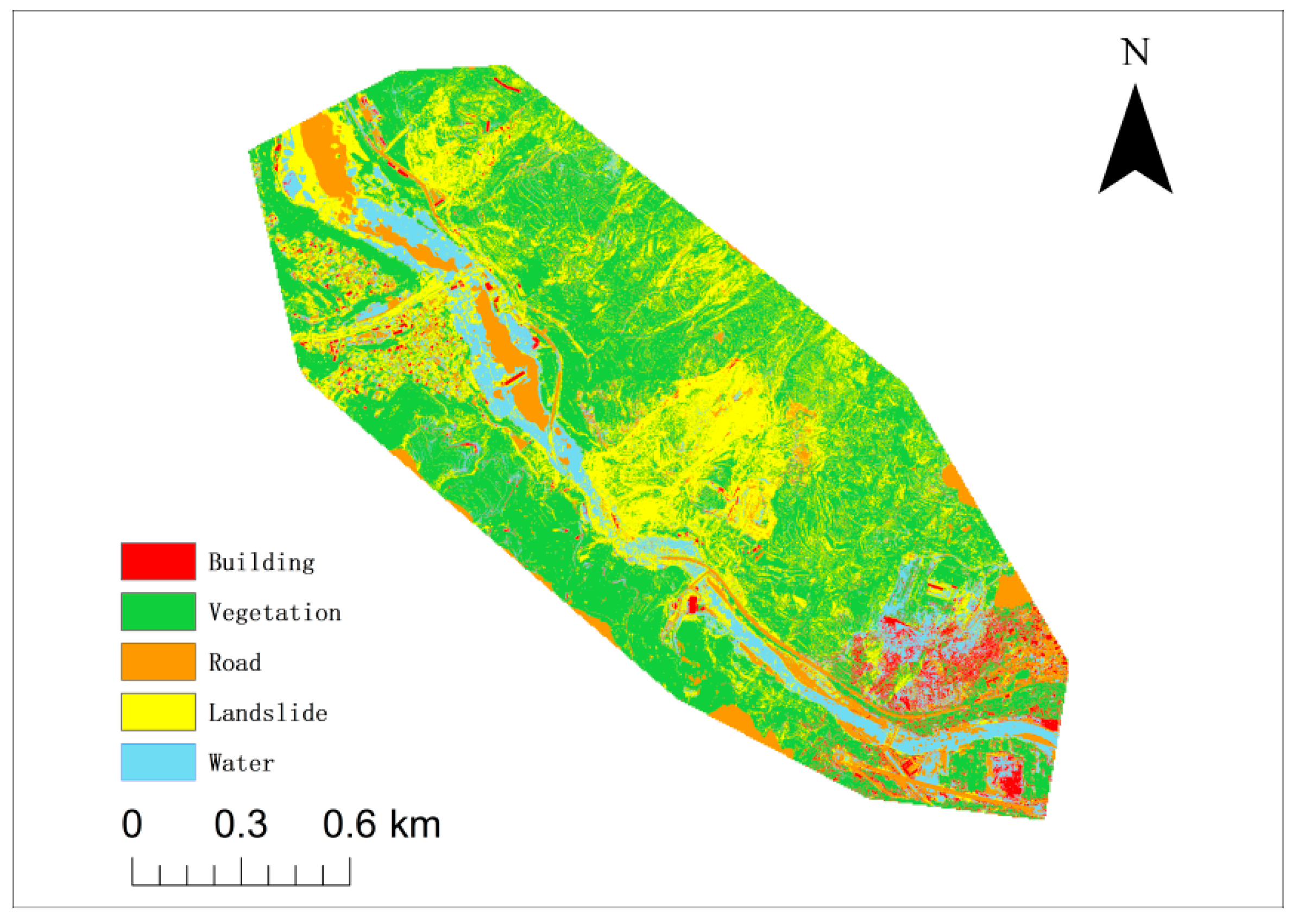
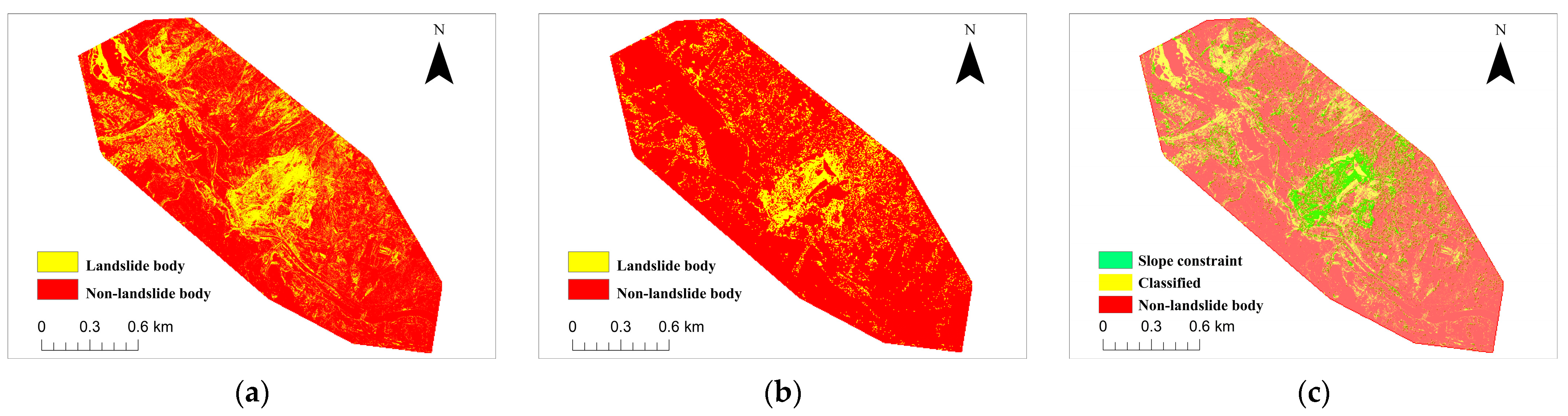
This study extracts landslide information in Jiangdingya by utilizing a combination of DEM topographic features and DOM image features. The study area, which is the Jiangdingya landslide in Nanyu Township, is characterized by diverse land cover types, including residential areas, vegetation, roads, and rivers. This diversity holds scientific significance and practical relevance for the research on landslide identification in complex terrains. The initial identification of landslides is conducted through supervised classification. In this process, slope information is utilized as a constraint for the supervised classification analysis. A threshold-based denoising filter and a morphological algorithm are introduced to further enhance the accuracy of landslide identification and extraction. These data can accurately depict geomorphic features of complex terrain and aid in identifying landslide-prone areas when combined with mathematical morphology processing. This contribution is important for identifying landslides in complex terrain and emergency disaster management. This approach provides value in addressing landslides in complex terrains.
2. Data and Methods
2.1. Study Area and Data
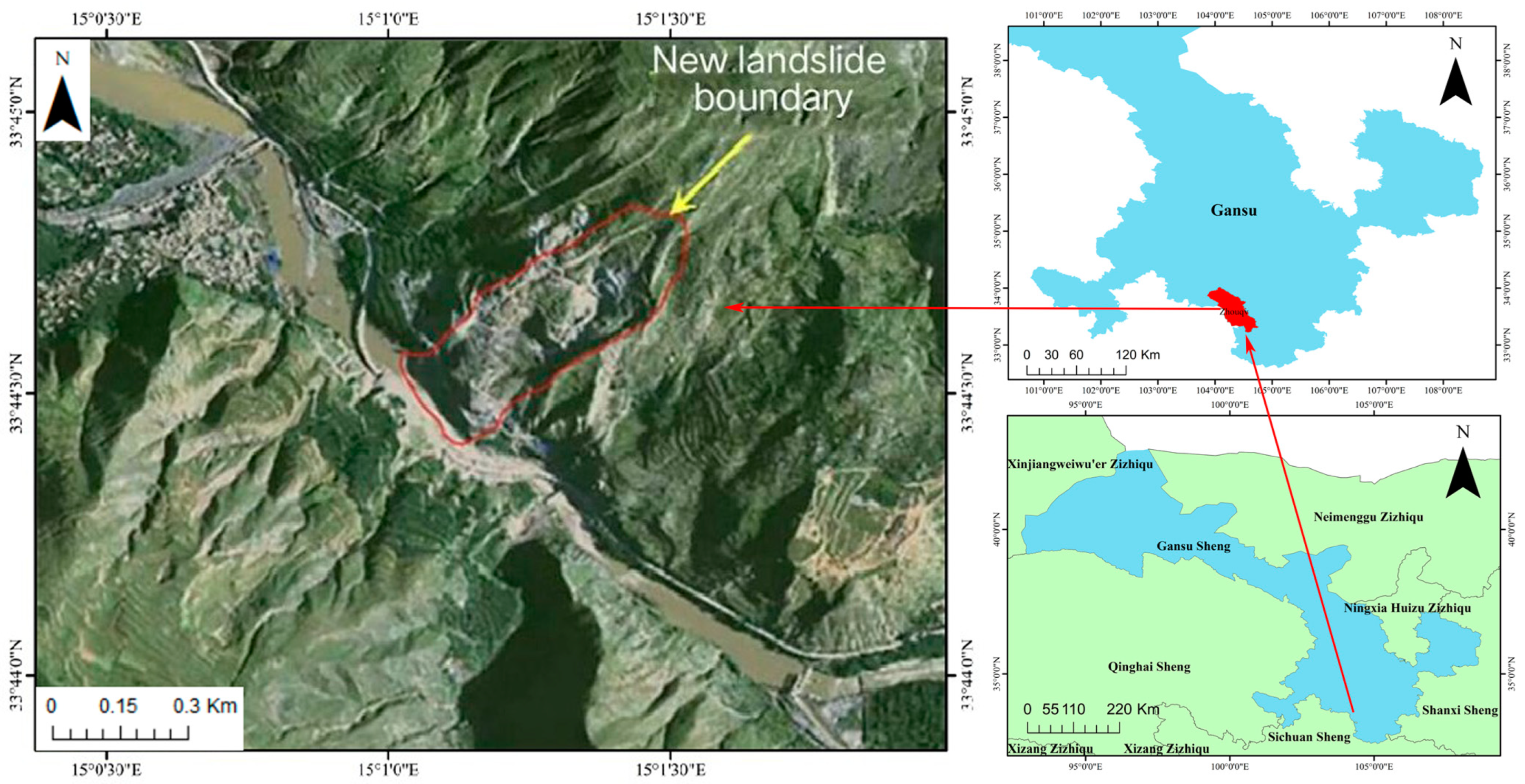
Nanyu Township, which is located in the northwestern part of China, is a township under the jurisdiction of Zhouqu County in the Tibetan Autonomous Prefecture of Gannan, Gansu Province. It is positioned at the southeastern boundary of Zhouqu County and is situated between 103°51′30″ and 104°45′30″ east longitude and 33°13′ to 34°1′ north latitude. The landslide occurred in Jiangdingya of Nanyu Township, which is located on the east bank of the Bailong River [
17].
According to statistics from the Zhouqu County Meteorological Station and the China Meteorological Data Network, the annual average rainfall in Zhouqu County is approximately 420.6 mm. The maximum rainfall within a 24 h period is around 63.3 mm, while the maximum hourly rainfall is recorded at 47.0 mm. Rainfall in the region commonly occurs in the form of continuous light rain and short-term heavy rain. During the rainy season, short-duration intense rainfall poses a significant risk of triggering landslides. The study area is situated within the northern and southern seismic zones of the Qinghai–Tibet Plateau, specifically in the Zhouqu–Wudu seismic subzone. It is one of the regions with the most intense neotectonic activity and is characterized by complex geological structures and severely fractured rock formations. In addition, it has undergone multiple phases of activity, which make it highly susceptible to rainfall-triggered reactivation of ancient landslides. As shown in
Figure 1 [
18], the landslide primarily consists of fragmented accumulations composed of light yellow-gray rock, carbonaceous shale, quartzite, and a small amount of loess. Furthermore, minor occurrences of sandstone, conglomerate, gray-green slate, and shale fragments are observed. According to the survey, Jiangdingya in Nanyu Township has a length of approximately 700 m, a width of about 240 m, and an area of nearly 0.16 km
2. It has an estimated average thickness of around 30 m and a volume of 500,000 m
3; therefore, it belongs to a large landslide [
19].
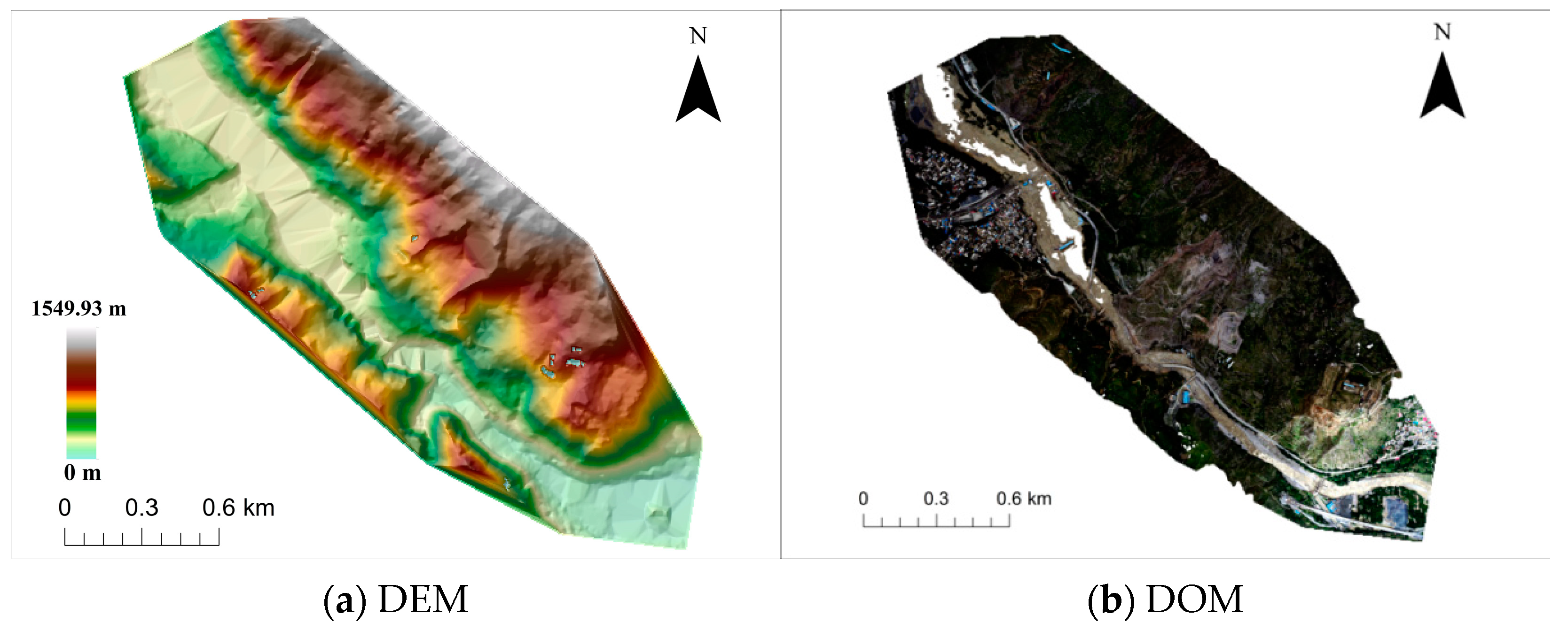
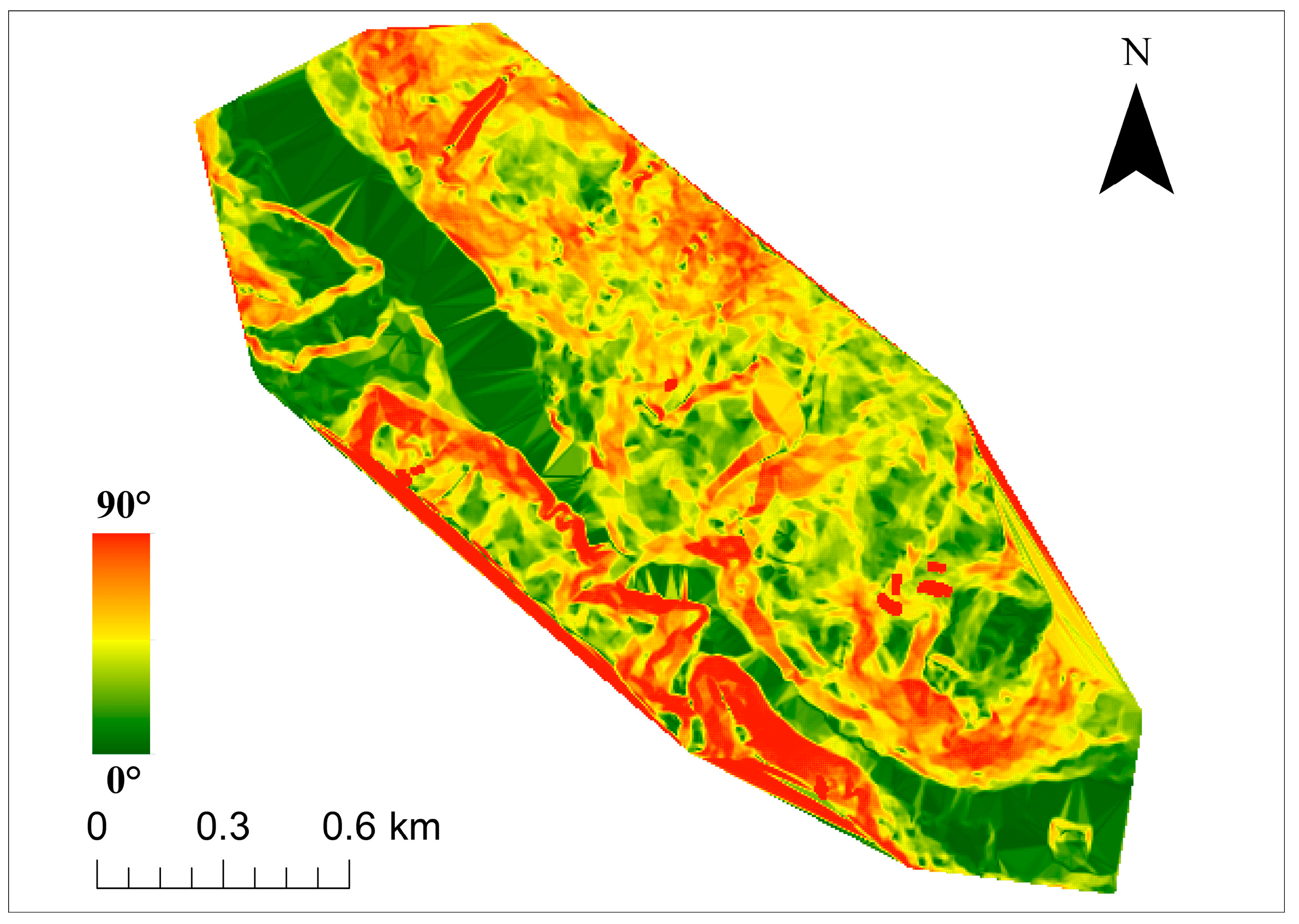
Landslide areas are usually complex, unstable, and potentially dangerous, which can be avoided by UAVs. At the same time, the flexibility and high-resolution characteristics of UAVs enable them to quickly fly to disaster sites for real-time aerial surveys. They can clearly observe the surface conditions of landslide areas and provide detailed information for disaster monitoring and assessment. The DEM and DOM are the core data of later information extraction, through which the spatial shape and surface texture information of the landslide can be obtained. High-precision three-dimensional point cloud data are generated by utilizing dense matching derived from aerial triangulation. These points, which feature ground characteristics, are transformed into ground control points that constitute a triangulated irregular network. A DEM is generated by employing the method of triangular interpolation. The DEM generates TIN images by image processing software based on the ground-point elevation data, as shown in
Figure 2a. The spatial resolution is 5 m. According to the high-precision DEM images, each photo undergoes digital differential correction, followed by stitching and mosaic processing to obtain the DOM image of the entire study area. The data of the DOM in the study area are obtained in GEOTIFF format, as shown in
Figure 2b. The spatial resolution is 1 m, and the coordinate system is WGS84.
2.2. Technical Method Process
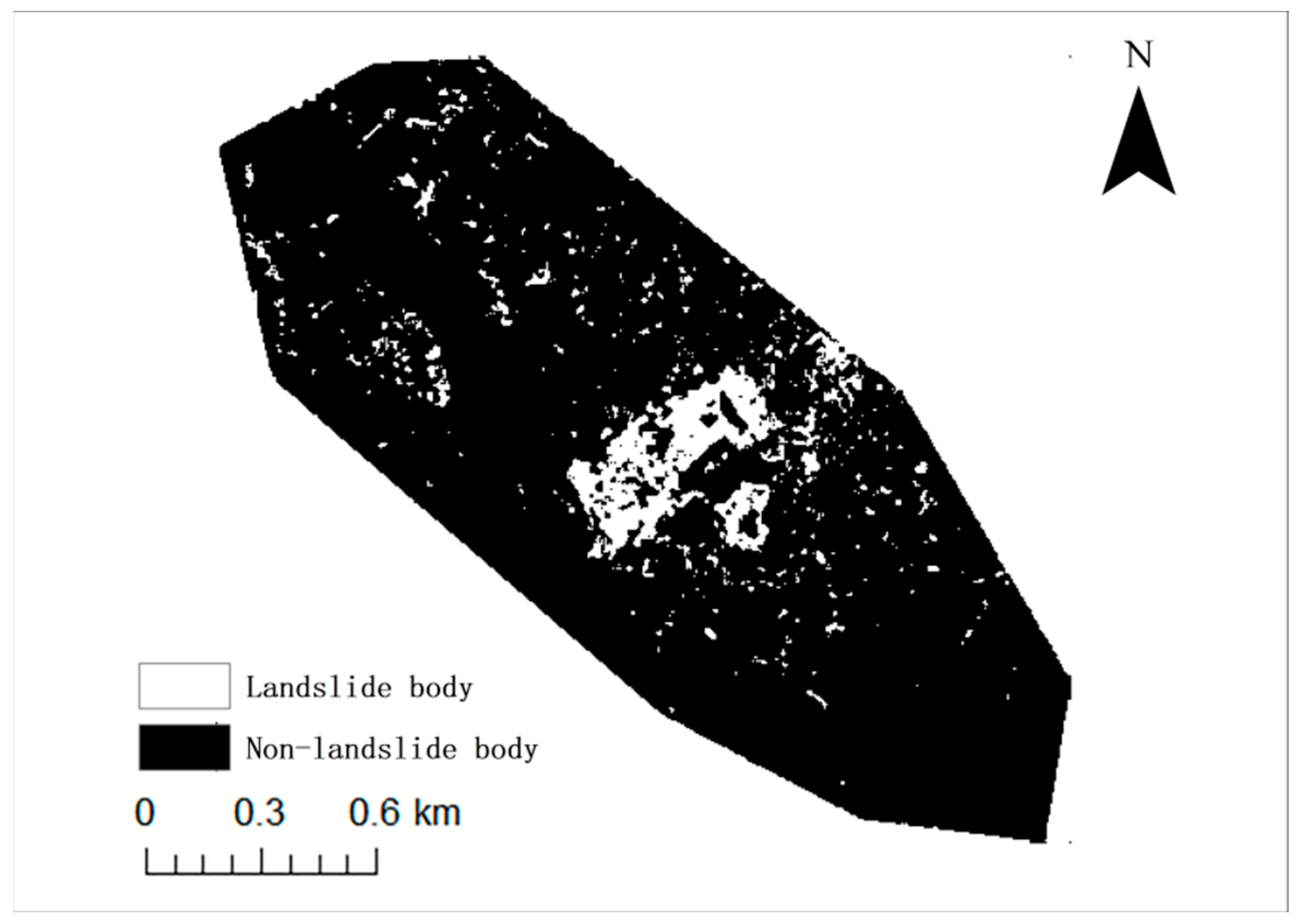
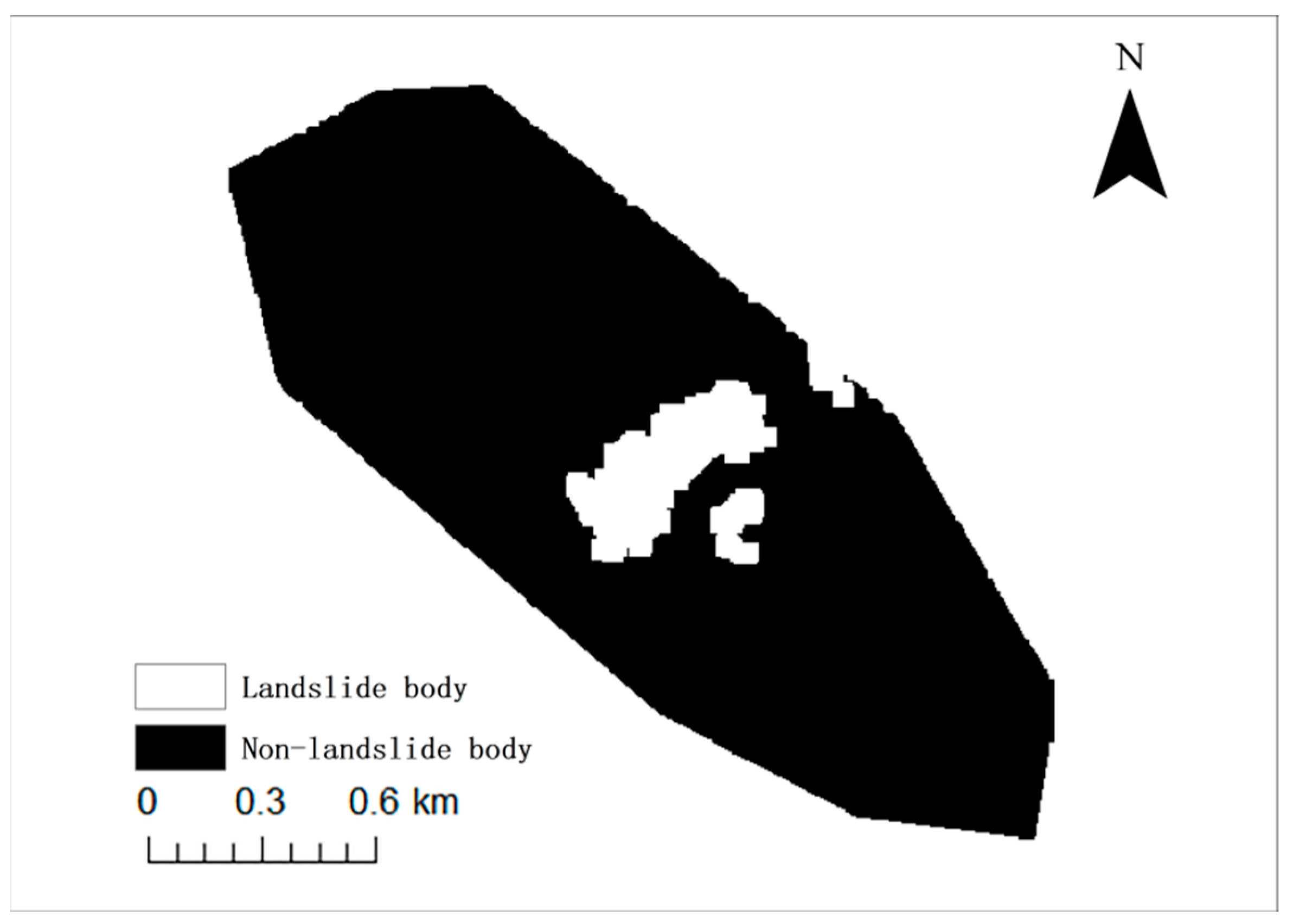
The technical process is shown in
Figure 3. Initially, supervised classification utilizing image-based object features is used for the preliminary extraction of landslide areas. The classification result is subsequently refined and analyzed by overlaying slope information, which leads to the identification and selection of the Jiangdingya landslide area. On the basis of this foundation, the application of mathematical morphology processing is implemented. The transformation of the image into a binary format is achieved by employing filtering, denoising, and thresholding methods. Subsequently, morphological operations, such as erosion and dilation, are applied to the binary image to derive the landslide area. Boundary information is extracted and overlaid with DOM data to facilitate recognition and analysis. This study experimented on multiple images using ArcGIS and MATLAB. See
Table 1 for specific parameters.
2.3. Principles of OTSU
The maximum inter-class variance method (OTSU) divides the image into two parts—background and foreground—based on the grayscale characteristics of the image. Variance is a measure of the uniformity of grayscale distribution [
20,
21]. A larger inter-class variance between the background and the foreground means a greater difference between the two parts that make up the image. When part of the foreground is incorrectly classified as the background or part of the background is misclassified as the foreground, the difference between the two parts becomes smaller. This method is mainly used to identify single targets such as landslides [
22,
23]. The best threshold selection method for this purpose is OTSU, which reduces the probability of misclassification between the foreground and background through inter-class variance. The OTSU algorithm is shown in Equation (1).
The optimal threshold for segmenting the image is the value of σ that maximizes the given equation. Among them, σ is the threshold for segmentation;
P1 and
P2 are the background scale and the foreground scale, respectively;
M1 and
M2 are the background mean and the foreground mean, respectively; and
MG is the mean of the entire image.
The expression is shown in Equation (2), and it can be simplified to Equation (6) when Equation (1) is more computationally intensive.
The gray level that maximizes the abovementioned equation is the OTSU threshold.
2.4. Principles of Mathematical Morphology
During the analysis of deformation signals, the convolution operation is primarily utilized as a method of linear transformation. However, mathematical models can be developed based on the introduction of partial order. In the monitoring of landslide deformation, a landslide deformation image operator can be developed using set theory [
24]. Consequently, the morphological transformation of the landslide deformation image is conducted using mathematical morphology based on the characteristics of the landslide deformation image.
Mathematical morphology is an image analysis subject based on mathematical theory, which integrates mathematics with topology. The fundamental concept is to utilize the defined structural elements for scanning the target image for processing and analysis. The fundamental operations of mathematical morphology mainly include erosion and dilation, as well as opening and closing operations [
25]. This study applies the operation process of mathematical morphology to analyze landslide deformation images. The process is as follows:
The basic concept of the dilation algorithm is that the structural elements belong to the target image, and the boundary elements are added to the image. The dilation of B to
A is expressed as
P and is defined as follows:
Among them, A and B are both sets in Q2; B is a structure; and A is the inflated set, that is, the target image.
The basic concept of the erosion algorithm is to remove certain elements of the object boundary. The erosion of
B to
A is expressed as
F and is defined as follows:
Among them, A and B are both sets in Q2, B is a structure, A is the inflated set A′, is the complement, and Φ is the empty set.
The open operation of the structural element
B on set
A is expressed as
K and is defined as follows:
Therefore, the open operation of B on set A is to corrode against A with B and then to expand the corrosion result with B.
The erosion and dilation operations in mathematical morphology are simple to use and highly efficient for processing. The combination of open and closed operations can also remove burrs and fill in holes. These characteristics also enable them to optimize and remove the noise in the initial segmentation of high-resolution remote sensing images, which improves calculation efficiency.
2.5. Evaluation Indicators
The effectiveness of landslide area identification methods is evaluated by generating a confusion matrix, which is then used to calculate the producer’s accuracy and user’s accuracy. In the multi-category problem, each category is considered “positive”, and the rest is considered “negative”.
Accuracy: The proportion of accurately classified samples among the total samples.
where
TP denotes the number of correctly classified positive samples,
TN is the number of correctly classified negative samples,
FP is the number of negative samples that are misclassified as positive, and
FN is the number of positive samples that are misclassified as negative.
Precision: The proportion of positively classified samples that are accurate among the entire set of positive samples.
Recall: The proportion of positive samples correctly classified out of the total positive samples.
4. Discussion
Traditional methods of landslide detection primarily rely on satellite remote sensing images for identification. However, the accuracy of landslide extraction is limited by the low spatial resolution of medium- and low-resolution satellite remote sensing imagery. Pixels are used as processing units, which leads to the prevalent salt-and-pepper effect. Moreover, obtaining high-resolution satellite remote sensing imagery poses a challenge. Meanwhile, in recent years, the use of UAVs has become more widespread. The data obtained from UAVs’ DOM have a high spatial resolution and contain rich spectral characteristics and texture information. However, the utilization of DOM data in the context of landslides is still less extensive than the use of satellite remote sensing.
In this study, a method for extracting landslides based on high-resolution DOMs and DEMs has been proposed. This method includes various steps, such as DOM classification, DEM terrain information constraints, filtering algorithms, and morphological processing. This method was validated using the Jiangdingya landslide in Gansu Province, China. The results show the capability of this method in identifying and extracting landslides.
Optical images are commonly used to identify spatial, spectral, and temporal changes evident on the Earth’s surface, such as vegetation clearance, cracks, and inconsistencies in material distribution [
29,
30]. This method may result in noisy and spectrally heterogeneous images, which causes difficulty in accurately distinguishing landslide areas from the surrounding environment and precisely comparing images across multiple time periods. This complexity may impede the analysis in capturing complex or subtle clues related to landslides [
31]. Ultimately, optical images cannot acquire information about subsurface deformations, whereas subsurface deformations can indicate the severity of slope failures [
30]. Compared with traditional methods, this approach preserves effective spectral and texture information in high-resolution DOMs. It also integrates spectral, textural, and morphological characteristics of the studied landforms to extract landslide information. In cases where the terrain variation is significant, the method incorporates DEM terrain information to remove features such as rivers, buildings, and roads. This way improves the accuracy of landslide extraction in complex terrains. This approach also incorporates median filtering and morphological operations. These techniques help achieve adaptive smoothing of classified images, which leads to a more objective and reliable result.
The method also has some limitations. First, selecting the optimal threshold is a challenging problem. The optimal threshold values varied across complex terrain. This method is designed for complex terrain and utilizes supervised classification and slope impact factor constraints to eliminate features and geomorphological complexities in such terrain. Eliminating the interference factors that may be encountered during the selection of optimal thresholds for automatic extraction is essential to achieve accurate landslide extraction.
Nanyu Township has experienced multiple instances of landslides in the past, which led to the existence of ancient landslide-prone areas. These factors can significantly impact sample selection and classification. The process of supervised classification is significantly influenced by the selection of regions of interest. Consequently, achieving the more accurate classification of landslide-prone areas can be significantly improved. The enhancement in supervised classification can be attained through the meticulous selection of samples that contribute to the model for labeling. The accuracy of the maximum likelihood method is slightly lower than that of other supervisory sub-methods. However, it is more suitable for identifying and extracting disasters in large areas without the need for the weight distribution of influence factors in the case of insufficient training labels [
32,
33,
34]. This procedure considers the significance and representativeness of the samples in relation to terrain and geomorphology knowledge [
30,
32]. The aim is to reduce labeling costs and enhance training performance. This study examines the intricate terrain of the area and categorizes its main features into five groups: landslides, vegetation, roads, buildings, and water. The samples are divided based on the feature information of the five types of features, and a supervised classification method suitable for complex terrain is used. This method has controllable model parameters and can be analyzed from various aspects, such as topography information and texture features, which contributes to strong interpretability [
35,
36].
5. Conclusions
This study applied DOM and DEM data, superimposed constraints using maximum likelihood classification, and combined them with filter denoising and morphological operation to extract the Jiangdingya landslide area in complex terrain. The experimental results are analyzed as follows.
The landslide areas were initially identified by combining the remote sensing image features of DOM data and the topographic impact factor in DEM data through using supervised classification and slope factor constraint analysis. This approach effectively eliminated the buildings, rivers, and roads that were erroneously buried by landslide deposits.
The images were denoised using a threshold-based median filter and the OSTU method. Then, they were classified into binary images. Mathematical morphological operations including dilation, erosion, and opening were applied to extract information on the Jiangdingya landslide area. Furthermore, the morphology and texture of the landslide area were analyzed and evaluated, which resulted in accuracy, precision, and recall rates of 98.02%, 85.24%, and 84.78%, respectively. The experiment shows the effective elimination of errors in the classification of landslides in buildings, roads, bare land, and other areas. This exclusion eliminates interference factors caused by a large amount of sediment covering rich ground object types and validates the application value of the method in extracting landslides in complex terrain.
In this study, samples are classified based on the terrain information of landslide occurrences in the study area. The characteristic information of terrain features is combined to select samples, which improves the accuracy of classification. Classification results are constrained with the assistance of DEM terrain information. Future research should consider relevant geological information and climate-influencing factors when classifying landslide states. InSAR technology has also been successfully applied to landslide extraction [
37]. In parallel, this method will be verified in other typical landslide areas in future work.


