Abstract
Designing integrating systems for support, real-time monitoring, and executing of complex missions is challenging, since they often fail due to high levels of complexity and overwhelming volume of input data. Past attempts have resorted to “ad hoc” solutions, which face issues of being non-updatable, non-upgradable, and not applicable to similar missions, necessitating a complete redesign and reconstruction of the system. In the national defense and security sector, the impact of this reconstruction requirement leads to significant costs and delays. This study presents advanced methodologies for organizing large-scale datasets and handling complex operational procedures systematically, enhancing the capabilities of Decision Support Systems (DSSs). By introducing Complex Mission Support Systems (CMSSs), a novel SS sub-component, improved accuracy and effectiveness are achieved. The CMSS includes mission conceptualization, analysis, real-time monitoring, control dynamics, execution strategies, and simulations. These methods significantly aid engineers in developing DSSs that are highly user-friendly and operational, thanks to human-reasoning-centered design, increasing performance and efficiency. In summary, the systematic development of data cores that support complex processes creates an adaptable and adjustable framework in a wide range of diverse missions. This approach significantly enhances the overall sustainability and robustness of an integrated system.
1. Introduction
In this research, we will present an advanced Decision Support System (DSS) capable of human-centric management of operational procedures which, in most instances, are characterized by their intricate nature [1]. These processes are sequential or parallel and distinctly well-defined and they constitute a mission in its entirety. According to specialists in operational terminology, a mission is defined as a set of interconnected or not operational procedures. These processes are intricately linked and heavily reliant on large-scale input datasets and information.
Furthermore, in this study, a complex mission is defined as a scenario within an environment that encompasses a multitude of actors and sub-actors as integral components of a system. This definition of complexity typically refers to scenarios involving extensive input data integration derived from both internal and external sources, coupled with a significant number of operational procedures or processes. Such missions demand an advanced DSS meticulously engineered to proficiently manage their procedures, ensuring the effective completion of the missions.
The DSS necessitates a well-structured design to function correctly in aiding the accurate planning and real-time execution of a mission within the system. It requires a structure for handling the necessary input data before entering in the system. This study introduces a novel SS sub-component, the Complex Mission Support System (CMSS or CMS system). Furthermore, this study proposes a new Decision Support System (DSS) scheme, in which a CMSS is interconnected to an Information System (IS) and the overall architecture constitutes a DSS. The CMS system is a kind of specialized system which resides in the intersection of DSSs and ISs (see Figure 1). The structure of DSSs, including some indicative functions, encompasses:
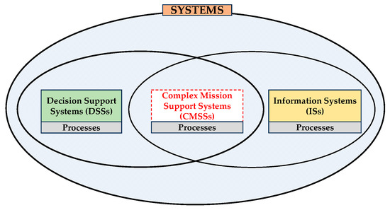
Figure 1.
CMSS as an intersection of DSS and IS.
- Decision Support System (DSS): This system plays a pivotal role in the design, monitoring, and real-time execution of missions. It includes a range of functionalities such as (a) designing the mission’s blueprint, outlining objectives, strategies, and resources, (b) monitoring the mission’s progress, ensuring adherence to the predefined plan, and (c) facilitating real-time adjustments and decision making during mission execution to respond to operational conditions of a dynamic nature.
- Information System (IS): This system is integral to data/information management, with functionalities including (a) managing input and output data/information, ensuring the accuracy and relevance of data used in decision-making processes, (b) handling data/information, encompassing storage, retrieval, and processing operations, (c) responding to Requests for Information (RFIs), ensuring timely and accurate dissemination of information, (d) implementing a computationally efficient classification of data/information to enable efficient categorization and retrieval, and (e) categorizing data/information thematically, which facilitates easier access and analysis for specific mission aspects.
- Complex Mission Support System (CMSS): This kind of system is designed for executing intricate missions, with features such as (a) producing detailed records of actions taken (log files), providing a comprehensive procedure footprint for efficient analysis, (b) predicting new intermediate (crucial for the mission) actions’ nodes, facilitating proactive planning and resource allocation, and (c) executing operational procedures efficiently, ensuring the seamless implementation of mission-critical tasks.
At this point, it is deemed appropriate to mention that the complexity of the procedures of CMSSs has been a significant challenge for IT engineers because it often exceeds the IS’s limits due to the inability of the ISs to organize and handle further incoming information [2]. The term complex mission support system is introduced as a description/characterization of one system that is used for supporting the design, simulation, monitoring, and control of any type of operational procedure (or complex mission as it is called by many operational experts). In an extended sense, these systems are also called command and control support systems because of their hierarchical operational structure [3]. Indeed, CMSS construction poses a significant technical challenge but, mainly, their creation is considered of major importance for the design and maintenance of national defense and security policy operations.
CMSSs need a multitude of information to operate properly. In particular, they usually demand georeferenced information which can be Two-Dimensional (2D) or Three-Dimensional (3D). In realistic operational scenarios, these CMS systems are dependent on information extracted from ill-designed data structures, either from data warehouses or other large-scale ISs. The creation of a CMSS presents an emerging scientific and engineering area of interest, while its efficient design and implementation is crucial for national defense planning [4].
The proper execution of complex procedures has been one of the most important factors affecting their outcome. The need for the construction and utilization of CMS systems in complex missions arises due to multiple factors: Firstly, the excessive complexity of the CMSS’s internal operational procedures, an emergent property of its nature and the volume of the input data [5]. Furthermore, the increased number of participant actors that are an internal part of the system in a mission, especially in cases of joint operations, which inherently demand a high level of coordination and synchronization [6]. Additionally, the large volume of operational input data needed, which are directly or indirectly geospatial [7]. Moreover, plenty of expertise of specialists and prior knowledge have already been standardized and/or formalized, both in the design phase and during the execution of a mission, but this knowledge is scattered and, in its totality, has not been integrated in a single IS. Last, but not least, the desire to use unexploited datasets of reliable quality (e.g., updated maps, regulations, guidelines, case laws in different geographical areas, etc.), as well as successful operational procedures (e.g., successful coordination of actors in search and rescue missions, use of standardized operational methodology where available, etc.) [8].
In general terms, DSSs are capable of managing, controlling, monitoring, and executing operational procedures, either scheduled or in an emergency [9]. This type of system has already been developed for realistic cases in the political sector for addressing natural disasters [10], epidemic incidents [11], transportation of inflammable or other hazardous materials, etc. [12] and in the security sector for search and rescue missions [13], urgent air transportation of patients [14], supply missions [15], and other similar complex missions in several areas in case of emergency situations [16] (see Appendix A).
However, it is widely known that these systems are designed ad hoc (i.e., for a specific purpose) and employ heuristic methodologies that may not necessarily be generalizable or applicable to other cases [17]. In the present study, it has been observed that the data required to support even simple operational procedures (e.g., search and rescue missions, transportation of sensitive or hazardous cargo, air transportation of patients and organs for transplantation, combating sea piracy, etc.) are usually of significantly high volume, often highly complex, and in the majority of cases, directly or indirectly related to maps [18].
In fact, the volume of these data continually increases, having already reached relatively large amounts. As a result, a system may become unmanageable or even uncontrollable. Additionally, these data often exhibit increased internal complexity and particular diversity of information required in missions, which further complicates the duty of operational officers who process these data [19].
The rapid dynamic changes of specific data (in terms of context, type, data structure, format, etc.) may present difficulties in being updated, potentially leading to considerable decision-making challenges for operational professionals [20]. Often, the presence of multiple autonomous entities producing distinct datasets leads to substantial issues concerning the internal coherence and compatibility of targeted data sub-sets. As a result, this inability to achieve internal interoperability and/or compatibility generally hampers the utilization of these data for operational procedures [21].
The bulk of information needed for DSSs is likely already developed in segments and of satisfactory quality, originating from multiple relevant authorities (e.g., governmental institutions, organizations, etc.) [22]. The way in which specific operational procedures are designed and executed by Subject Matter Experts (SMEs) has significant similarities among such procedures regardless of the kind of mission. The aforementioned SMEs are highly knowledgeable trained officials performing specialized functions in given processes. Nonetheless, the ability to develop solutions may markedly differ among operational officials; the fundamental principles of human reasoning used in designing missions are common among all operational officials. The procedures that any participant actor applies in any kind of mission present similarities (common segments). These common procedure segments have already been standardized or even established as common procedure templates by operational officials for a considerable number of missions [23] (see Appendix A).
However, to fully exploit the potential offered by the aforementioned similarities, in this work it was deemed necessary that certain actions ought to be taken as follows: (a) Constructing data cores which are organized in a systematic way to support complex operational procedures and (b) developing a general adaptable and adjustable framework of methodologies, based on the aforementioned data cores, to support a considerable thematic range of different operational procedures.
This research introduces specific methodologies and techniques for organizing and handling large-scale information in DSSs for complex missions with the goal of resolving complexities associated with diversity, polymorphism, and information volume. The aforementioned combinatorial solutions include:
- 1st Methodology: Use of information organization of the incoming data in the CMS system, based on purpose. This methodology emphasizes purpose-driven information organization. Aligning operational procedures with specific purposes aids efficient information organization correlating each action with the data required for mission support [24].
- 2nd Methodology: Use of thematic decomposition of complex operational procedures based on their thematic content, as well as the geographical area where they take place [25].
- 3rd Methodology: Use of a novel mission design algorithm for identifying key intermediate objectives, enabling the CMSS to easily and flexibly handle any kind of complex operational procedure, following crucial intermediate steps in order to accomplish a mission successfully.
- 4th Methodology: Use of a novel system architecture called a “teleological structure” or “thematic content map”. The aforementioned architecture ensures the sustainability of a complex system because it resembles the way in which the human mind works, correlating each subject or issue that it is called upon to address with the corresponding sub-sets of data and computational methods required to solve a particular problem or issue. Components of the teleological methodology are used in the three aforementioned methodologies by appropriate adaptation to CMSSs. So, a CMSS that implements the teleology method gains flexibility and functionality by simplifying the operational procedures/processes without negatively influencing the successful completion of a mission [26].
- 5th Methodology: Use of an organization of geodata called “themes over maps”, that optimally fits the aforementioned teleological structure. The themes over maps approach is more suitable for complex missions than the frequently applied architecture called “maps over themes” because it is totally aligned to the way in which the human mind works, correlating each subject or issue with the problem that it is called to solve [27,28]. Components of this structure are used in the entire system by suitable adaptation to the IS, which is interconnected with the CMSS. So, the integrated system that implements the themes over maps structure can provide to any of its components the actionable information required for the successful completion of a mission.
The aforementioned methodologies and techniques can significantly address the severe issue of CMS system rejection stemming from the inability of the system to support cases other than that for which it was created. In practice, the rejection of a CMS system leads to redesign and the construction of a new one, entailing cost- and delay-related issues.
1.1. Related Works/Existing DS System Methodologies
After conducting a literature review on the scientific field of the present study concerning methodologies and techniques in DS systems, an overview of the most prominent studies is carried out. The key characteristics of various DSSs and their areas of application were identified and are presented in this state-of-the-art sub-section. For instance, the authors of [29] describe a method using model-based systems engineering to develop an unmanned aerial system digital twin, focusing on route optimization in military contexts with multiple attribute utility theory to improve decision making and reduce human error. Similarly, Ref. [30] presents a system for selecting surface units for search and rescue operations at sea using an Automatic Identification System (AIS) and multi-criteria decision analysis. Extending these developments, Ref. [14] proposes a DDS for Medical Evacuation (MEDEVAC) in military operations and emergencies, aimed at enhancing the efficiency of medical personnel in triaging and evacuating casualties from a region. Furthermore, Ref. [31] presents the F-35 system, designed for pilots to execute advanced tactical missions. The DSS of this aircraft equips pilots with enhanced situational awareness and decision aids, facilitating critical and timely decision making. Additionally, Ref. [32] proposes a modular control solution integrated with the DSS to effectively plan, execute, and monitor intricate missions involving multiple drones. Complementing these approaches, Ref. [33] assesses the efficacy of neural networks in an Electrocardiogram (ECG) DSS for categorizing heartbeats as normal or abnormal, thus supporting medical professionals to make an assessment of the patient’s state and helping them proceed with the appropriate therapy. In a similar vein, the authors of [34] present a web-based DSS to efficiently predict, plan, and respond to fire and flood events. This system utilizes Earth observation data and real-time weather information. Moreover, the authors of [35] present a DSS design to improve police patrolling efficiency by integrating predictive policing capabilities with patrol districting models. The system aims to optimize the allocation of police resources by predicting crime risks and efficiently distributing police officers across patrol areas. The authors of [36] discuss the development and successful implementation of an advanced smart support system for operators of remotely operated vehicles, particularly those designed for navigating long-distance routes synchronously, accurately, and safely. Lastly, the study presented in [37] focuses on the development and implementation of a DSS designed for a low-voltage grid that integrates renewable energy sources, specifically photovoltaic panels and wind turbines. This system is aimed at proposing decisions for achieving an energy balance within a pilot microgrid, thereby reducing reliance on external power networks.
1.2. The Structure of the Present Study
The present manuscript is organized as follows:
- In Section 1, an introduction is provided, along with a proposal for a novel system structure and methodologies that merge a CMSS with an IS, forming an integrated DSS.
- In Section 2, the focus is on the critical challenges and methodologies involved in managing data and improving the decision-making process in complex mission scenarios, elaborating on the development and organization of CMSSs and ISs. This section is organized into several sub-sections:
- Section 2.1 discusses the data requirements and structural design necessary for creating CMSSs.
- Section 2.2 outlines the specific data needs of operational specialists for successfully executing complex missions using CMSSs.
- Section 2.3 focuses on addressing the challenges associated with managing extensive datasets in ISs.
- Section 2.4 explores the unique aspects and design challenges of SSs.
- Section 2.5 covers the structured development of data cores for efficient information by describing five methodologies for organizing data and complex operational processes in DSSs.
- In Section 3, methodologies and structures used in a CMSS-based mission are comprehensively described, providing insights into its design, organization, and comparative advantages. This section is organized into several sub-sections, each dedicated to a different aspect of the mission, for example:
- Section 3.1 introduces a mission-representative example, serving as a proof of concept for the CMSS.
- Section 3.2 analyzes how data are structured and managed in the mission example, representing the first methodology applied within the CMSS framework.
- Section 3.3 focuses on breaking down the mission content into themes or components, illustrating the second methodology in the CMSS approach.
- Section 3.4 delves into the specific algorithms or processes used in designing the mission within the CMSS, highlighting the third methodology used.
- Section 3.5 explores the goal-oriented aspects of the mission design, discussing how the mission’s objectives are structured and achieved, representing the fourth methodology.
- Section 3.6 describes a unique approach where thematic elements are prioritized over geographical or spatial considerations in mission planning, indicative of the fifth methodology in the CMSS.
- Section 3.7 provides a comparative analysis of the CMSS with other existing systems or methodologies in the domain, highlighting its uniqueness and advantages.
- In Section 4, a detailed discussion explores various aspects of enhancing decision-making systems:
- Section 4.1 emphasizes the importance of high-quality input in DSSs, CMSSs, and ISs.
- Section 4.2 highlights the critical role and necessity of developing these systems.
- Section 4.3 shifts focus to the efficient enhancement of data and procedural organization within these systems.
- Section 4.4 examines the potential limitations and challenges associated with the proposed CMSS in depth.
- Section 4.5 discusses practical considerations for implementing the CMSS framework in real-world applications.
- Section 4.6 explores future perspectives and emerging trends in CMSS.
- Section 4.7 explores the uncertainty in large-scale datasets and the role of fuzzy and interval data in enhancing DSSs.
- In Section 5, the conclusions of the present work are stated.
- This study is accompanied by Appendix A, Appendix B, Appendix C, Appendix D and Appendix E that offer detailed insights into various facets of the subject matter (e.g., organization and structuring of data within an IS, development and architecture of algorithms used in designing missions, mathematical equations, formulas, relationships, and expressions that enhance the understanding of the examined approaches, etc.)
- Lastly, a list of the references and relevant bibliographies used in the present study is given.
2. Materials and Methods
This section presents the crucial data requirements and mission algorithms necessary to support operational specialists in complex missions. It addresses the technical challenges of managing voluminous datasets within a DSS that have a negative influence on the system performance. Furthermore, this section also elucidates specific methodologies and techniques that leverage the reasoning capabilities of specialists to streamline the organization of data and processes within the DSS, contributing to the optimal function and performance of algorithms to effectively support the completion of the mission.
2.1. Identification of Input Data Requirements and Internal Frameworks for the Development of CMSSs
A rigorous examination was carried out on data and program requirements for supporting operational procedures in order to study the characteristics of desired data cores and programs. Representative examples of complex missions (outlined in Appendix A) were reviewed, highlighting their prevalence among the most frequent missions encountered by operational officers in their professional experience. Additionally, extensive interviews were conducted with operational specialists from various sectors in order to examine the realistic data and program needs for supporting the operational procedures which they are responsible for handling. These interviews helped in acquiring of a significant number of different types of critical operational information. This information directly yielded data and program requirements for the development of general DSSs to support complex missions of broad thematic range (as outlined in Appendix B).
2.2. Input Information Requirements in CMSSs for Operational Specialists to Successfully Execute Complex Missions
By conducting interviews with the operational specialists, who are an inextricable part of the present study, valuable operational experience has been gained and therefore actionable information has been gathered towards the development of a general system for the effective support of complex missions, for the needs of the present study. The aforementioned information can be categorized into two main groups (see [24] and for more details Appendix B):
- The common information. It is the type of information which usually satisfies common needs and operational requirements of mission actors. The most characteristic aspects of this information are presented below:
First of all, there is information including the time-constraint context. This type of information has the potential to heighten the complexity of a mission. This results in altering the mission structure which may require significant modifications to the required information. For instance, the allocated time for mission execution, the strategic utilization of timelines, obligations, and prioritization may undergo substantial changes. The analysis of a mission hinges upon the limitations imposed by time and the corresponding informational prerequisites [38].
Furthermore, there is another kind of information concerning the terrain characteristics, encompassing its morphology such as vegetation, river pathways, points of higher elevation, areas with high visibility, evacuation routes and pathways, etc.
Moreover, an additional type of information concerns environmental conditions such as temperature, wind speed, humidity, visibility, cloud concentration, fog, etc. It is imperative to proactively take these factors into consideration before embarking on a mission. Special emphasis should be given to instances where weather conditions impact the landscape, especially during intense rainfall or flooding, as well as when topography influences communication channels and the extent of visibility [39].
In addition, information concerning the capabilities and qualifications of actors in a mission significantly affects the success of the entire mission. Key determinants also include the number of actors, their designated duties, their level of training, their readiness to handle emergencies, and the possibility of continuous flow of information. These factors stand as pivotal considerations throughout a mission.
In addition, all types of information related to available technical or specialized equipment are crucial, encompassing vehicles, communication protocols, area surveillance systems, motion detection systems, telecommunications relays, satellites, etc. The quantity and quality of available technological resources, their adaptability to the specific needs of the mission, as well as their availability, decisively facilitate the execution of the mission.
Also, the type of information concerning vulnerabilities and potential threats is important and related to the possibility of partial or complete failure in achieving the objectives of a mission. In operational jargon, vulnerabilities encompass scenarios, procedures, and malicious actions stemming from external sources such as disasters and sabotage that can lead to loss of human life and damage to infrastructure, such as failures in communication and security systems, vehicle malfunctions, etc. Examples include, among others, congested roads, security issues, disruptions in primary or backup power supplies, ongoing construction within the mission’s geographic area, etc.
Moreover, numerous vulnerable points could arise during a mission, necessitating specific analysis. These points, with a high likelihood of emergence and impact on mission success, essentially represent threats. Consequently, experts are compelled to address them with utmost priority. When specific conditions align and pertinent critical events unfold, a particular threat escalates into a crisis, as defined in operational terminology.
Alongside, information concerning legislation and laws introduces heightened legal duties and law restrictions for the involved actors and operators. They should consider these factors and if they align with their directives or commands issued by superiors.
Last, but not least, additional significant types of information require specific operational protocols encompassing data capable of altering the current mission scenario in either advantageous or detrimental ways. This kind of information includes an extensive range of themes, such as demographic statistics of regions, economic and tourist activities, command-and-control center details, geographic zones of interest, transportation, communication networks, etc.
- Specialized information satisfies the special (particular) needs of actors not only to obtain a satisfactory real-time situational awareness, which is the ability to perceive, understand, and effectively respond to an unexpected situation in an operational field, but also to be capable of acting appropriately with precision and time exactness, maximizing the probability of mission success. A characteristic specialized example is the specialized information required during any Search and Rescue (SAR) mission concerning an aircraft pilot. SAR missions require, among others, (a) information regarding the aircraft type, accident location, time of incident, flight trajectory towards the critical crash area, etc., (b) pilot-related information covering pilot identity, equipment, potential pilot responsibility for the aircraft’s crash, current pilot status, etc., (c) environmental details regarding terrestrial or aquatic conditions, present and future weather conditions at low altitudes, potential obstacles or hindrances for search and rescue operations, etc., (d) authorities’ response details encompassing the availability of agencies for SAR, their operational capabilities, resource availability, equipment, materials, search and rescue personnel required, etc.
The majority of the previously mentioned actionable information, either common or specialized, is georeferenced, directly or indirectly, and it requires particular handling. The aforementioned necessity makes the acquisition and update of this information highly costly due to its typically extensive volume, requiring a level of detail far beyond the conventional SS’s capabilities. Further details of actionable information required in realistic missions are presented in Appendix B.
2.3. Addressing Technical Difficulties in Managing Large-Scale Input Datasets within ISs
In most cases where large-scale IS systems are developed to arrange georeferenced data, the data to be organized within a system (before the input in the system) typically display various notable features:
- Serious structural complexity and complicated interconnections among their components [40].
- Substantial diversity in their configuration, encompassing various definitions, contents, forms, and formats [41].
- Highly increased thematic diversity due to numerous of additional actors and heterogeneous procedures [42].
- Most importantly, a notable degree of polymorphism, indicating variability in how data are defined and their content across different versions. These versions are tailored to meet specific purposes for which the data are used [43].
As a consequence of these identified traits, most of these systems do not easily carry out domain adaptation (thematic shift) to different missions/operations. These systems are not easily manageable, and they become exceedingly challenging to be maintained, updated, and upgraded and they reach a state of unmanageability. Consequently, this leads to their rejection as domain-agnostic solutions. The geographical nature of the data further exacerbates these challenges by significantly amplifying the data’s complexity [44].
2.4. Distinctive Traits of SSs—Difficulties Involved in Their Design
A review of the literature has revealed that the majority of available systems supporting complex operational procedures do not serve as optimal models for constructing necessary data warehouses. This is due to a number of reasons. Firstly, their design relies on ad hoc heuristic methods and internal structures that often lack suitability for handling large volumes of multi-thematic data [45]. In addition, the methodologies used for their development and implementation cannot be standardized or applied universally to similar cases and challenges [46]. Moreover, their data cores lack the desired internal interoperability [47]. Another key point is that they encounter issues regarding updating and upgrading their internal procedures. They tend to become unmanageable computationally or even uncontrollable by the user [48]. Equally important, as these systems scale in size and complexity, their sustainability diminishes significantly. They become practically non-expandable or modifiable in terms of their functionalities. As previously stated, these systems become overburdened with this growth and the only viable solution appears to be the complete replacement of the old system with a new one. This approach is excessively drastic and incurs prohibitive costs. Additionally, when numerous actors are involved in designing and executing complex operational processes, it is highly likely that challenges will emerge concerning aligning these procedures and their associated input data. In particular, in military operations, CMSSs struggle to receive large volumes of input data, despite the international efforts to achieve standardization for input data and interoperability among different data sources. Along with the above, in many cases, the presence of multiple independent data sources creates significant hurdles, leading to internal interoperability issues or data sub-sets that clash, severely impeding or entirely obstructing their utilization in operational processes [49]. Above all, the data crucial for supporting complex missions, mainly tied to maps, tend to be voluminous and complex, adding layers of complexity to their management. Furthermore, the constantly changing nature of specific data complicates the updating process, potentially causing disruptions in decision-making protocols whose efficient implementation is time dependent [50]. Last, but not least, given the vast range of complex missions, the data needed can be highly diverse and polymorphic. This diversity poses substantial computational and algorithmic challenges in organizing these data within ISs [51].
It should be emphasized that the current organization of the data is not due to problems or weaknesses of the IS’s capabilities, but it is a remnant of the old traditional and convenient method of handling georeferenced information based absolutely on maps. In contrast, especially in human-centric missions, data organization in maps is not compatible with the human way of thinking, in which the data organization is based primarily on the subjects that should be solved and secondarily on maps. Therefore, the traditional method of organizing georeferenced information has a clear upper limit of usefulness because the volume and complexity are increasing.
2.5. Systematic Development of Organized and Sustainable Data Cores—Dissemination of Information
In this sub-section, methodologies and techniques are presented for achieving systematic development of well-organized and sustainable data cores in DSSs, fully leveraging human intelligence in realistic missions (e.g., intelligence rules, common similarities in operational procedures, etc.).
2.5.1. Information Organization of the Incoming Data in DSSs, Based on Mission Purposes (1st Methodology)
The organization of information in a CMSS should be guided and controlled by the mission purposes for which the necessary sets of information needed will be used, either by operational specialists or computer engineers. Additionally, it is imperative that the dissemination of data to the desired addressee or eventually to the general public is not anarchic, a procedure which is known as the principle of the need to know [52]. Simultaneously, the dissemination of the content of each operational procedure, which always correlates with an actor and the information needed for the execution of a mission, should be based on the purpose for which it is being carried out, which is far more practical and efficient. The methodology of organization of information based on purposes, which will be presented in the following, has a direct relationship with the teleology methodology. Figure 2 illustrates the classification of data required by the operational needs of an actionable actor. It becomes evident that the majority of these essential data are common across most complex missions. In the context of the DSS proposed in the present study, an actor is characterized as actionable due to the capability of making decisions at crucial points during the mission’s lifecycle.
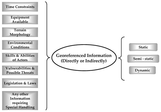
Figure 2.
Categories of information needed for CMS (based on mission purposes).
It is easily understood that, according to human reasoning, information is generally organized by prioritizing issues related to procedures that are encountered in complex missions. Afterwards, these procedures are associated with the information needed to support a mission (i.e., issues and sub-issues). It is worth mentioning that this information is georeferenced, directly or indirectly, and is considered highly critical for the success of a mission.
2.5.2. Thematic Decomposition of Complex Operational Procedures (2nd Methodology)
The predominant approach utilized in the design and analysis of operational processes is the segmentation/division of these procedures into distinct sub-procedures (in operational terminology the operational procedures could also be named mission/subject/issue). This segmentation, known as the thematic decomposition of operational procedures, is performed based on the thematic content of the mission and the geographical area in which the procedures will be executed. The process of thematic decomposition operates through a systematic analysis wherein each mission is dissected into primary sub-missions (1st level), and subsequently, each of these sub-missions (2nd level) undergoes further segmentation into subsequent sub-missions (nth level), continuing iteratively until they reach a point where further division is non-achievable. Each sub-mission within the mission should be precisely articulated, detailing its specific requirements. This structure conforms to an acyclic graph structure resembling an nth-level tree, where n ∈ ℕ*. Hence, situated at the apex of this nth-level tree structure lies the primary mission, branching out thematically into a number of sub-missions for each actor. This hierarchical decomposition continues downwards until the initial mission is exhaustively broken down into its most elementary thematic components.
Figure 3 contains an example of thematic decomposition of a complex mission, with application to the case of a transport mission. In Figure 3, it is observed that there is an initial transport mission (point “A”). This mission is divided into further sub-missions, which are sub-mission “transport from A to B”, sub-mission “point B”, sub-mission “transport from B to C”, sub-mission “point C”, sub-mission “transport from C to D”, and sub-mission “transport from C to E”. In this example, each sub-mission cannot be further divided, so in practice that means it is operationally manageable, well-defined, and with its requirements precisely specified.
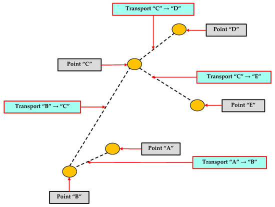
Figure 3.
Example of thematic decomposition of an initial complex mission (tree-like graph structure).
The degree of thematic decomposition in a complex mission always depends on the executive capability and qualifications of the operational experts in mission design, who decide based on their experience and on empirical criteria such as available time, level of training, readiness of participant actionable actors, etc. to break down the mission into smaller segments in a versatile and convenient way. This tactic is considered necessary during the mission-planning phase for achieving efficient mission analysis. The methodology of thematic decomposition of information based on mission purposes has a direct relationship with the teleology methodology, basic elements of which have been presented in [26].
2.5.3. Input Data Organization within IS Solution for IT Engineering Challenges
It is apparent that any mission, irrespective of its magnitude, comprises sub-missions characterized by complex operational procedures. Numerous and diverse operators and actors take part in varying command and control tiers/levels. Each of these sub-missions necessitates operational data, which for operational officers are notably voluminous, complex, and diverse. As a result, their management necessitates specialized approaches, even within sub-missions. A major challenge faced by IT engineers is the disorderly structure of data warehouses and ISs, leading to failures due to their immense load (weight) and the inability to efficiently organize and handle large volumes of data. A potential future remedy might involve the following algorithmic steps:
- Step 1: Enter thematic information in the system and classify it according to mission objectives and purposes.
- Step 2: Categorize information by theme, time, and geographic relevance aligning with the operational requirements of the mandatory expert data and input information (with thematic content) into the system (referred to as thematic directory list of information).
- Step 3: Seek additional operational information essential to support the mission’s primary goals promptly and accurately.
- Step 4: If required information is inaccessible, explore alternative information sources that could indirectly aid in assessing the current situation and support mission purposes.
- Step 5: Upon identifying available information enabling rational conclusions, source this information from appropriate channels.
- Step 6: In cases where no relevant information is available, revisit the directory list of information and adjust the mission’s objectives to locate pertinent existing information facilitating an equivalent assessment.
- Step 7: In cases where finding equivalent information proves impossible, iterate through the process of adjusting the mission’s objectives to discover preexisting relevant information leading to an equivalent assessment and support mission purposes.
- Step 8: If the effort of adjusting fails to yield the desired equivalent results, revisit the list of information (directory) and further adapt the mission’s objectives to retrieve information with satisfactory assessment for supporting the mission purposes.
- Step 9: Repeat this algorithmic procedure iteratively until sufficient assessments for the mission are achieved.
The aforementioned approach is a comprehensive detailed process, emphasizing adaptability in aligning mission objectives with available information. This seems to outline a systematic approach for information handling in a mission. Further details about the previous algorithmic process for data organization in an IS, as described in the previous context, are provided in the form of a pseudocode based on C#, shown in Appendix C.
Additionally, in Appendix C, a detailed analysis of the algorithmic complexity of the pseudocode that was implemented by the previously described methodology is presented. The time complexity of this algorithm is estimated to be O(n log n), and the space complexity is O(n). These complexities are based on the selected data structures deemed optimal for each step of the algorithm.
2.5.4. Mission Design Algorithm for Identifying Key Intermediate Objectives for CMSS (3rd Methodology)
In the case of a large number of actionable actors involved in designing and executing operational procedures—from the simplest to the most complex and extensive ones—it is likely that issues of harmonizing these processes may arise. This is attributed to two main reasons:
- The purpose for which these procedures are performed varies according to each involved actionable actor.
- The definition and form, or the content of each operational procedure, differ among different actionable actors.
Efforts in the past to establish interoperability among relevant actionable actors, common operational terminology, and harmonization of respective operational procedures have not yielded the desired results so far. The harmonization of all relevant operational procedures (including their necessary corresponding data) executed by the actionable actors involved in a complex mission can be attained by identifying essential intermediate objectives. These objectives are crucial in achieving the final goal of the mission. A mission-planning algorithm has been created, where the mission underwent thematic decomposition. According to this technique, the mission was divided into smaller segments based on designer operational criteria, which are termed fundamental mission segments. In these segments, operational procedures take place and there are intermediate objectives. The completion of these intermediate objectives also means the completion of the corresponding mission segment. The completion of all mission sub-segments leads to the completion of the entire mission. It is worth mentioning that the mission segments are selected by an operational mission designer according to his experience based on the time needed for mission completion and logical thematic mission analysis. The algorithm’s steps are as follows:
- Step 1: Creation of a list of fundamental mission segmentsIn the mission design phase, each mission is divided into fundamental mission segments to ensure functional and operational manageability, employing appropriately selected segment lengths. This technique, known in engineering terminology as “divide and conquer”, allows for effective thematic mission sub-divisions [53]. It is crucial for each sub-division to account for any temporal or spatial constraints that might influence the lengths of these fundamental segments.
- Step 2: Creation of a list of points of interestPoints of Interest (POIs) are defined within each fundamental mission segment for operational planning reasons because their completion leads to the success of the mission. POIs are preplanned and considered of high priority because of the necessity for specialized handling and specific operational scrutiny during mission design and execution. POIs are selected at the discretion of the officials of the plan and are primarily map related; however, they might also encompass the concept of time or carry a logical interpretation and usefulness. These POIs necessitate the investigation of operational procedures, e.g., communication, mission criteria, conditions, situational awareness, record log files, etc. The number of POIs depends on the operation designer executive’s capability to decide with operational accuracy in order to achieve successful mission completion. In a sense, POIs can also be referred to as transition nodes. Before and upon them, the appropriate operational actions should be executed effectively throughout the mission. These actions are related to the mission’s success status, namely the total completion of the mission, the possibility of partial failure, and the potential abortion of the mission if demanded by the circumstances.
- Step 3: Creation of a list of fundamental mission segments with their POIs.This list is created by the outcomes of step 1 and step 2.
- Step 4: Creation of two iterative procedures, defined as external and internal loops.The use of the fundamental mission segments and POIs leads to a novel algorithm characterized by two iterative procedures, one of which (referred as internal, “In”) is nested within the other (referred as external, “Ex”):
- The external iterative procedure (Ex-loop) involves transitioning from the beginning of each fundamental mission segment to the beginning of the next.
- The internal iterative procedure (In-loop), nested within the external iterative procedure, involves transitioning from one POI to another within each fundamental mission segment.
The aforementioned iterative procedures are capable of describing any objective, intermediate or not, due to their exceptionally high generality. This characteristic strongly implies that the algorithmic process itself is inherently generalized. - Step 5: Execution of the mission design algorithm methodology inside the CMSS.The documentation of a mission construction design algorithm encompassing the transition from the external to internal iterative procedure is described in pseudocode based on C# (see Appendix D for further details).Additionally, in Appendix D, a detailed analysis of the algorithmic complexity of the pseudocode that was implemented by the previously described methodology is presented. The time complexity of this algorithm is estimated to be O(n2), and the space complexity is O(n2). These complexities are based on the selected data structures deemed optimal for each step of the algorithm.
In the following Figure 4, the visualization of the mission design algorithm is depicted.
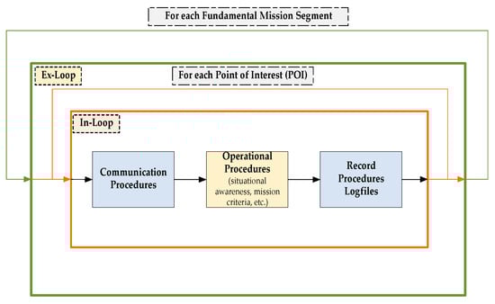
Figure 4.
Representation of mission design algorithm.
In the following Figure 5, a diagrammatic flow chart is presented, in which the external loop (“Ex-loop”) and the internal loop (“In-loop”) are shown. The generalized mission design algorithm has been generated as a flow chart by using code in the MATLAB programming language (MATLAB, version R2022b; MathWorks Inc.: Natick, MA, USA, 2022).
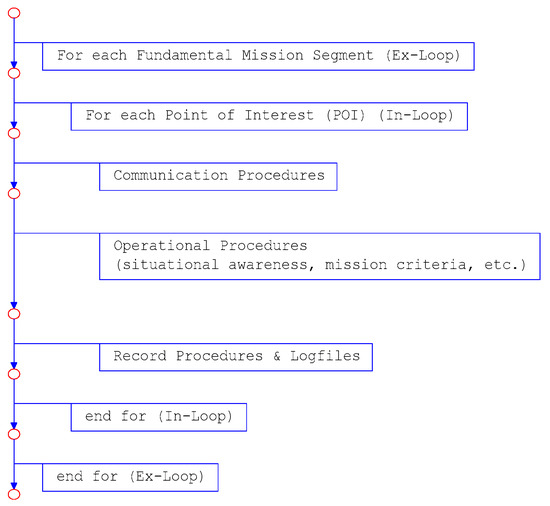
Figure 5.
Diagrammatic flow chart of mission design algorithm.
The significant similarities in operational procedures (common or not), regardless of the type and nature of a mission, have led the Subject Matter Experts (SMEs) to design and execute complex missions by standardizing or even creating templates for operational procedures across a broad range of complex missions. This standardization defines the type of operational procedure, including the data needed, to achieve the objectives of complex missions. In this way, a high degree of harmonization was achieved, and it is feasible due to the fact that a generalized core of operational procedures (related to the data needed) can be created for application in different complex missions.
A detailed presentation of the aforementioned generalized diagrammatic algorithm was adjusted for designing and executing transport missions; it is in its final stage of completion by one of the authors (George Tsavdaridis) and is planned to be published in the near future.
2.5.5. Use of the Teleological Architecture for Organizing Systems (4th Methodology)
The teleological structure (also called as system content map), derived from the metaphorical meaning of the ancient Greek word “telos” which means purpose, is a specialized metadata structural architecture. It stems from a way of human thinking, as described earlier, and correlates each subject or issue (of a mission, a procedure, etc.) with the respective sub-sets of data and computational methods that must be used to solve those specific problems or issues. The content map serves as a precise representation detailing sub-sets of data and metadata, along with computational methods and programs associated with each thematic issue or sub-issue within a system. Indeed, the themes, issues, problems, concerns, or challenges requiring information stored within the IS serve as a conceptual index for the data and information housed within it. Hence, one could define the content map of the system as a teleological structure, as it delineates the inherent purpose behind the existence of data clusters and computational procedures within the system. The teleological structure resides within a distinct database and serves as an ongoing resource for organizing and accessing the core data and programs within the system. The teleology methodology has been outlined in [26,54,55]. A brief overview of each of these sections is provided below.
The metadata structure of teleology has been partitioned into two parts for improved readability (i.e., Sections Thematic (Mission) Decomposition of Teleological Architecture and Data/Indicators Cores and Computational Methods of Teleological Architecture). Section Exemplary Architecture of a System with Teleological Organization presents an example system structure with teleological organization.
Thematic (Mission) Decomposition of Teleological Architecture
The first part of the content map (or teleological structure) pertains to the thematic decomposition of the system. The content map of the system starts from the thematic list of the system, as Figure 6 indicates.
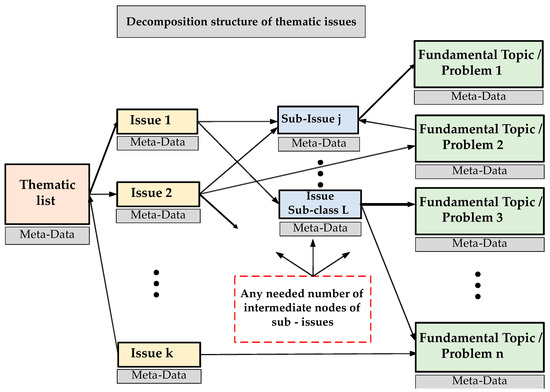
Figure 6.
Decomposition structure of thematic issues.
The teleological structure originates from a distinct cognitive process and aligns various subsets of data and metadata within a system with thematic content (mission, sub-mission, issue, sub-issue, etc.). Essentially, the system’s missions or sub-missions serve as a conceptual guide for organizing the associated data within an IS. Thus, a thematic list is created, through implementation of a comprehensive decomposition of all the subjects addressed in the mission, composing a tree graph structure, where the tree’s leaves represent non-divisible entities or fundamental subjects, and they directly lead to a list of corresponding indicators. For a deeper exploration, further details are available in [26].
Data/Indicators Cores and Computational Methods of Teleological Architecture
In the second part of the teleological structure, a proper metadata structure describes the input data/variables and the data sources. This structure includes the descriptions of the indicators (i.e., the specific information that is needed by decision makers), as well as descriptions of the methods for computing these indicators from the input data, as shown in Figure 7.
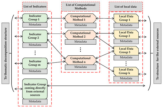
Figure 7.
Data cores/indicators and computational methods.
In any operational procedure, effectively managing internal complexities and diverse data necessitates a meticulous thematic breakdown within the system. It is imperative to achieve clear and precise indicators that accurately capture the essence of the data. This involves ensuring that every sub-set of desired indicators corresponds directly to a set of computational methods represented by the following equation:
i = f(d)
In Equation (1), i stands for the specific indicator(s) arranged in a vector, f denotes the method utilized for computing these indicators, and d represents the input data vector essential for the computation of these specific indicators.
Adherence to this comprehensive thematic list makes the system inherently updatable, upgradeable, and, hence, generally evolvable and sustainable. In the final format of the table of map contents (or teleological structure) of the system, each sub-set of input data (variables) is correlated with the data sources from which they were obtained. More extensive descriptions, which are omitted here for simplicity, can be found in [25].
For a detailed mathematical foundation of the methodology, along with a comprehensive set of mathematical formulas describing an explanatory implementation, the reader is referred to Appendix E.
Exemplary Architecture of a System with Teleological Organization
The exemplary implementation of a system can include several components, which are depicted in the following Figure 8. Further detailed information about the teleological architecture can be found in [26].
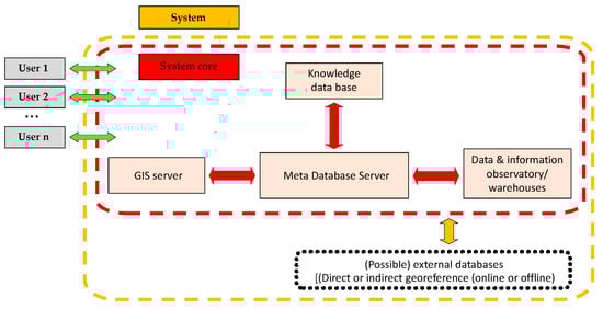
Figure 8.
Exemplary system architecture with teleological organization.
Methodology for Bringing Order within Systems Based on Teleological Architecture
In this sub-section, according to the previously described teleological structure, an exact, novel methodology is presented for creating and maintaining highly organized datasets. For supporting complex missions and operational procedures, the methodology will be described in terms of a sequence of steps:
- Step 1: Identify, at the highest possible level, important missions or complex operational procedures which a supporting system can substantially support.
- Step 2: Assign priorities to the identified missions or complex operational procedures. If necessary, restrict the selection of missions according to technical, financial, or any other necessary criteria and select the missions which can be supported.The previous two steps are common at any level of command (e.g., national, strategic, and operational).
- Step 3: For each remaining mission or set of complex operational procedures, start recursive decomposition into simpler sub-missions (or sub-procedures). Gradually, a tree-like structure is created that looks like an acyclic graph. This graph comprises many levels depending on the number of sub-missions which have been created. Every sub-mission is well-defined, detailed, and simpler than the layer above. Stop the decomposition at sub-missions that: (i) can no longer be divided into simpler ones. We shall call these sub-missions fundamental. In the tree-like structure, each fundamental sub-mission appears as leaf; (ii) have an unambiguous description of their input (data), methodology of computation (methods or programs), and output. This output consists of indicators which are the data that permit decision making.
- Step 4: For each one of the fundamental sub-missions, specific data input will be needed for the SS. These input data are completely specified by the necessary indicators. Practice has shown that it is necessary to completely define the following:
- The exact form and format, as well as the necessary characteristics, of these data, according to their intended use.
- The sources from which these data have to be acquired.
- Any necessary procedures for cleansing, filtering, transformation, or merging of the acquired input data, so that the needed data can be computed. This sub-step may have a very wide range of difficulty.
- Exact procedures for regular and timely updating of the data.
- Step 5: If data gaps remain, then:
- First, examine if there is a way to directly compute the missing data from other available data.
- Then, examine if there are any other available data from which it is easy to make good-quality estimations for covering the gaps of missing data.
- If good-quality estimations cannot be found, look for sub-missions similar to the fundamental ones (as defined in step 3), which may involve different indicators, computed from data, for which good-quality estimations can be obtained.
- Otherwise, try to collect new input data.
- Step 6: In the case that data gaps still remain after steps 4 and 5, try to further back-track in the tree-like structure of the decomposed missions for a sub-mission that can be modified so that, eventually, computable indicators can be found, without compromising the actual aims of the mission.In a considerable number of cases, this back-tracking may involve going several levels up, and actually redesign a part of the mission, until all data needs are satisfied.
- Step 7: From the list of the fundamental sub-missions of the initial mission, create:
- a total indicators list,
- a total list of the computational methods (program list),
- a total data list, which is used as input to the computational methods to produce indicators), and
- a total list of updating procedures, in order to regularly and timely update the data cores of the system.
- Step 8: Organize all the information produced so far in a composite, advanced database, which is governed by a meta-database of critical importance, named a teleological structure. The prior algorithmic process mandates that all generated descriptions be systematically arranged within the teleological meta-database. Meanwhile, all remaining data must find their place within the composite database.
In the previous procedure, any problems of terminology or different names used by different actors for the same sub-missions, indicators, or data have to be tackled. In case a thematic shift of the dataset is needed, one has to start by augmenting the teleological structure, as will be explained later on. Data cores, organized according to the proposed methodology, can easily and seamlessly be distributed geographically if the need arises.
Use of Organization of Geodata Called “Themes over Maps”, Based on Teleological Structure (5th Methodology)
The most advanced georeferenced data architectures today look like the abstraction scheme in Figure 9. This scheme starts from one or more sets of stacked layers of maps to parts of which additional information is linked. This additional information can be either kept in an internal database or collected from external databases in real time. The administrators of the external databases can be dispersed over the entire World Wide Web. For this architecture, the term “maps over themes” could be established. Although this architecture is a powerful one, it has an upper limit of usability, as the volume and the complexity of the georeferenced information are increasing.
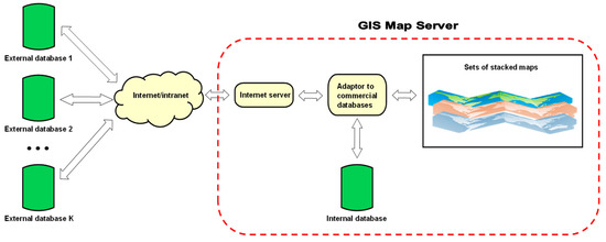
Figure 9.
“Maps over themes” architecture.
There is an architecture called as “themes over maps” which was presented for the first time in a number of EU-funded transportation projects for the needs of Project ETIS Agent of Program Growth. According to this structure, the system could perform an on-demand and on-the-fly joining of information retrieved from external or internal databases. The aforementioned architecture enables the actionable actor/user to select and request information needed (user selection guided). The information needed by an operational actionable actor is linked to the content map (teleological structure). The system then automatically and without any intervention by the user produces maps for the user with the desired information. The “themes over maps” methodology substantially enhances the manipulation capabilities of geospatial data and harmoniously integrates with the teleological structure or content map of the system. The “themes over maps” architecture looks like the abstraction scheme shown in Figure 10.
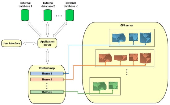
Figure 10.
“Themes over maps” architecture.
The “maps over themes” architecture has been adjusted to systems for design, monitoring, control, and execution of operational procedures and additional details can be found in [27,28].
3. Results
As previously mentioned, traditional DSSs used in the design, monitoring, control, and execution of complex missions have limitations in their functionality, i.e., the type of mission they support, the volume of required input information, etc. In particular, CMS systems often struggle to expand their functionality capacities. This is because any further development of their conventional data cores necessitates updates, upgrades, and, ultimately, enhanced control mechanisms. Consequently, the sustainability of these data cores becomes a significant concern. Hence, the issue of the sustainability of these cores is apparent.
The techniques described in this work provide solutions with specific methodologies to address the issues of high volume, serious internal complexity, increased diversity, and interoperability concerning CMS systems. The combination of the aforementioned methodologies and techniques effectively reinforces the functionality of the proposed DSS. As shown in Figure 11, the proposed DSS architecture overview includes an IS that has two sub-systems:
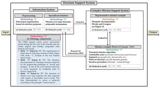
Figure 11.
Overview of the proposed DS system architecture.
- The first sub-system (noted as “a” in Figure 11) concerns the preprocessing stage aiming at preparing to organize the input data before they enter the system that will support any mission and has a relationship with methodology “1” because it fixes the anarchic and disordered data input in the system.
- The second sub-system (noted as “b” in Figure 11) concerns the stage after the data preprocessing stage. In this phase, the preprocessed dataset undergoes more specialized organization based on a way of organizing data related to actionable actors’ needs. This phase has a relationship with methodology “5” (“themes over maps”).
The other component running in parallel to the IS is the CMS system, which implements methodology “2” (noted as “c” in Figure 11) involving thematic mission decomposition through the divide and conquer technique and “3” (noted as “d” in Figure 11) encompassing the mission transport algorithm, actionable actors, segments, Points of Interest (POIs), and other elements. The data dissemination to actors is achieved according to the principle of “need to know”. According to this principle, the actionable actor requests, handles, and analyzes only the absolutely necessary information according to one’s judgement and according to the actor’s operational needs (to avoid information overloading). Methodologies “1”, “2”, “3”, and “5” optimally fit with methodology “4” (noted as “e” in Figure 11), teleological structure, for supporting complex missions.
3.1. Representative Mission Example: Proof of Concept (PoC) in CMSS
Let us consider a representative example of a transport mission (see Figure 12). The mission starts at point “1”, and it branches into two sub-missions. The first, concerning the transportation of a briefcase containing classified documents via a police vehicle (actor “1”), starts from point “1” and proceeds to point “3”. The second, concerning the transportation of a patient by an ambulance to a hospital (actor “2”), starts from point “1” and terminates at point “2”. The two sub-missions are “fundamental sub-missions”. This means that each sub-mission is well-defined and there is no need for them to be further divided because their operational requirements are clear.
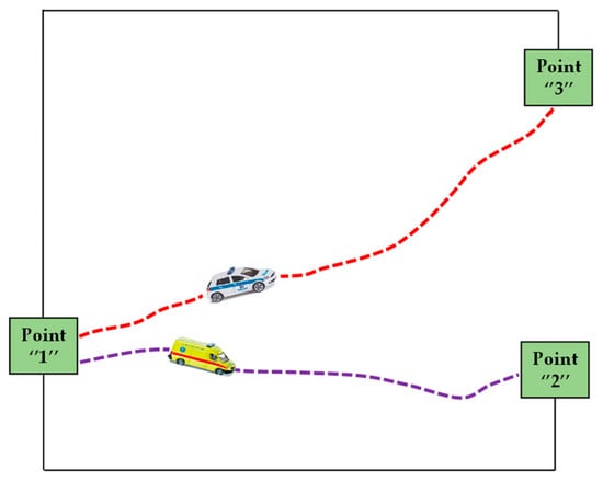
Figure 12.
Representative example of a transport mission in CMSS.
By implementing the five methodologies previously described in Section 2.5 for the systematic development of organized and sustainable data cores, the results of the PoC analysis, which are presented in the following sub-sections, are achieved.
3.2. Data Organization in Representative Mission Example (PoC in CMSS): 1st Meth
The available information for the needs of the aforementioned representative mission example has been organized systematically before entering the system by aligning with the mission objectives. Methodology “1” optimally fits with “4” (teleological structure) in order to support complex missions. Applying the algorithmic process for classification (as described in Section 2.5.3), we obtain:
- Mission overview: objective “1”—transport of classified documents from point “1” to “3” with a police vehicle (actor “1”) and objective “2”—transport of a patient from point “1” to “2” with an ambulance (actor “2”).
- Step-by-step application of algorithmic process for classification.
- Step 1: Enter thematic information in the system, i.e., objective “1”—classified document transportation, classify under theme “security for documents”; objective “2”—patient transportation, classify under theme “medical emergency for the patient”.
- Step 2: Categorize information by inputting in the system and creating thematic directories. For the present representative mission, an example could be security and medical, immediate transport requirement, potential delays, geographic points “1”, “2”, “3”, assess routes and distances, etc.
- Step 3: Seek additional operational information, i.e., traffic conditions, route security, medical facilities en route, availability of resources: police and medical personnel, etc.
- Step 4: Explore alternative information sources, i.e., if route information is lacking, check local news, traffic apps, community alerts, etc. If direct contact with a hospital is impossible, check regional health databases, etc.
- Step 5: Source information from appropriate channels, i.e., use police networks for security information, hospital records, and emergency services for medical information, etc.
- Step 6: Adjust mission objectives if necessary, i.e., if certain routes are blocked or unsafe consider alternative paths, if the nearest hospital is not available find the next closest one.
- Step 7 (if step 6 does not work): Iterate to find equivalent information, i.e., reevaluate routes and available facilities to find new information based on real-time input data.
- Step 8 (if step 7 does not work): Adapt mission’s objectives further, i.e., if continuous obstacles arise, try to adapt the mission’s objectives based on urgency and time constraints. Prioritize one of the two missions based on the aforementioned criteria and consider additional criteria such as the departure and arrival times, resource allocation, etc.
- Step 9: Repeat iteratively (i.e., go to step 1), namely, reassess mission objectives, ensuring that each adjustment brings the mission closer to an achievable outcome, by simultaneously correlating the information needed to the adjusted mission objectives.
The data organization technique, as outlined in the representative mission example, offers distinct benefits both from the perspective of the actionable actors involved in the mission and from the standpoint of design engineers of the system. The benefits for actionable actors in the mission are as follows: Firstly, decision making is enhanced, since actors receive well-categorized, relevant information that aids in making informed decisions quickly, which is crucial in time-sensitive missions. Secondly, efficient resource allocation is provided by the clear thematic categorization, e.g., security and medical, which allows specialists to effectively allocate resources (personnel, vehicles, etc.) based on the mission’s specific needs. Thirdly, adaptability to changing conditions, due to the iterative process of updating and reassessing information, enables specialists to efficiently change circumstances, such as route alterations due to traffic or emergencies, etc. Furthermore, increased operational awareness, given the continuous integration of input data with relevant categorization (e.g., traffic conditions, route security), provides actors with a comprehensive understanding of the mission’s current status. In addition, it offers risk mitigation by considering potential obstacles and seeking alternative information sources and therefore actors can foresee and mitigate risks, enhancing the mission’s safety. Moreover, communication and coordination are optimized, since the structured approach streamlines communication between different actors, e.g., police, medical teams, ensuring better coordination and collaboration.
The benefits of the data organization technique from the design engineer’s perspective are as follows: Initially, systematic data management enables the system to categorize and to prioritize data, ensuring efficient handling and retrieval of mission-critical information. In addition, the system’s design allows scalability and adaptability to different mission types and sizes by supporting various thematic categories and real-time updates. Furthermore, robust information processing, since the system is engineered to process a wide range of data sources, e.g., local news, traffic apps, ensuring comprehensive situational awareness. Last, but not least, this design achieves improved data accuracy and reliability, since the system’s design enhances the accuracy and reliability of the data input by accessing information from appropriate channels and sources, e.g., police networks, medical records, etc.
In summary, this data organization technique significantly enhances the mission’s execution by providing actors with a clear, adaptable, and comprehensive operational situational awareness, while from an engineer’s standpoint, the system is robust, flexible enough, and able to handle complex mission requirements effectively.
3.3. Thematic Decomposition in Representative Mission Example (PoC in CMSS): 2nd Meth
The representative mission example is divided into two sub-missions and has undergone thematic decomposition. In fact, the representative mission example has branched into different thematic sub-missions, which are point “1” to “3” and point “1” to “2”. The organization and analysis of the representative mission example are based on the geographical area where it takes place. The technique of thematic decomposition plays a crucial role in the success of complex missions, since it offers the following benefits:
- Clarity: By splitting the mission into two sub-missions (point “1” to “3” for document transport, and point “1” to “2” for patient transport) each team—the police and the ambulance crew, respectively—has a clear understanding of their distinct objectives. This clarity ensures that each actor knows his route, his cargo (i.e., classified documents or a patient), and specific operational requirements.
- Efficiency: Resources can be allocated specifically for each sub-mission. The police vehicle used for the documents can be equipped accordingly for security, while the ambulance can be equipped with medical supplies. Independent tackling of each sub-mission prevents resource overlap and ensures that each mission is carried out with the appropriate means and actors.
- Risk assessment: Operating the two sub-missions separately allows for a more focused risk analysis. For the police vehicle, the primary risks might involve security threats, whereas for the ambulance, the primary risks are related to medical emergencies en route. This separation allows each team to prepare for and mitigate their specific risks effectively.
- Communication: Clear communication channels can be established for each sub-mission. The police team will have a dedicated communication line focused on route security, while the ambulance crew will maintain communication with medical personnel. This prevents communication misunderstadings and ensures that each team receives the information needed.
- Resource optimization: Resources, e.g., fuel, personnel, equipment, etc., are allocated precisely according to the needs of each sub-mission. The police vehicle might require additional security personnel en route, while the ambulance may need medical staff (communicating remotely with the medical center of operations) and equipment (from local health centers). This targeted allocation prevents resource waste.
- Quality control: The flow of input information contributes to quality control for each thematic sub-mission, e.g., document transport might require assurance for the security of the information, while patient transport involves maintaining high medical care standards.
- Adaptability: If, for example, there is a traffic jam en route to the hospital, the ambulance can adapt its route independently without affecting the document transportation. Eventually, the existence of two distinct sub-missions ensures that changes in one sub-mission do not unnecessarily complicate or delay the other.
- Problem isolation: If the police vehicle encounters a problem, such as a mechanical failure, it can be addressed without directly impacting the patient transportation. This isolation of problems prevents a domino effect, ensuring that a problem in one area does not escalate to affect the other sub-mission.
This thematic decomposition approach indeed provides a comprehensive framework for managing complex missions, enhancing effectiveness and efficiency while reducing risks and improving communication and quality control.
3.4. Mission Design Algorithm in Representative Mission Example (PoC in CMSS): 3rd Meth
The use of a mission design algorithm for identifying key intermediate objectives enables the CMSS to easily and flexibly manage any kind of complex operational procedure, following successive steps in order to lead to the completion of the mission. By adjusting the algorithm to the representative mission example given consideration in this study, the following results arise:
- The creation of a list of fundamental mission segments. The mission is divided into two primary segments: segment “a” which concerns the transport of classified documents from point “1” to “3” (by police vehicle, actor “1”) and segment “b” which is the transport of a patient from point “1” to “2” (by ambulance, actor “2”). Each segment is independently manageable and designed considering the unique requirements of its cargo transportation.
- The creation of a list of Points of Interest (POIs). For segment “a” (document transport), potential POIs could include traffic lights or secure checkpoints, areas of high traffic, locations requiring specific navigation strategies, etc. For segment “b” (patient transport), potential POIs might include a tunnel or local health centers, where the ambulance is forced to make a short stop over due to the patient’s condition, the fastest routes for emergency transport by-pass, etc. In both cases, POIs are selected based on the urgency, security needs, and operational complexities of each transport mission.
- The creation of a list of fundamental mission segments (with their POIs). The representative mission example segments are combined with their respective POIs, as follows: (a) path of segment “a” from point “1” to “3” with its POI “1”, which is a traffic light, (b) path of segment “b” from point “1” to “2” with its POI “2”, which is a tunnel.
- The creation of two iterative procedures (external and internal loops). The external loop (Ex-loop) could involve transitioning from the preparation phase at point “1” to the execution of segments “a” and “b”. This loop involves two repetitions, one for each segment. The internal loop (In-loop) could involve, for segment “a”, transitioning between POIs from point “1” to “3” and, for segment “b”, transitioning between POIs from point “1” to “2”. For each segment scanned through the external loop, this internal loop involves as many repetitions as the number of POIs along the segment’s path. In the case considered in this study, for each segment the inner loop contains a single repetition for the one POI shown in Figure 13. These loops facilitate the operational flow of the mission, ensuring that all necessary actions are taken at each POI.
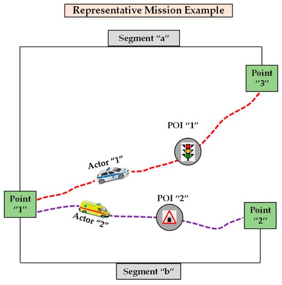 Figure 13. Mission design algorithm in representative mission example (PoC in CMSS).
 - The execution of the mission design algorithm methodology in the CMSS. The algorithm for the transport representative mission example is totally documented and executed in a CMS system. This includes the specifics of handling each type of cargo (e.g., classified documents and a patient), the different transport vehicles (e.g., police vehicle and ambulance), and any other logistical or operational requirements.
By adapting the algorithm to this representative mission example, we focus on the challenges of transporting sensitive documents and a patient, ensuring that each sub-mission is effectively managed and executed. In Figure 13, the mission design algorithm in the representative mission example (PoC in CMSS) is illustrated.
The mission design algorithm outlines the ability of the CMSS to easily and flexibly handle any kind of complex operational procedure. The successful completion of the predesigned intermediate steps leads to the completion of the representative mission example. This offers distinct benefits from both the perspective of the actionable actors involved in the mission and the system design engineer:
- The benefits for specialist actors include the structured operational approach to complex missions. The algorithm breaks down complex missions into manageable segments by including Points of Interest (POIs). This approach provides operational versatility to actors to understand and effectively execute their missions. Moreover, clarity in operational roles and responsibilities is provided by identifying key intermediate objectives, and each actor knows their specific role at every stage of the mission, reducing confusion and increasing efficiency. Furthermore, enhanced decision making due to the predesigned, well-defined POIs and mission segments aids actors to make decisions, especially in dynamic and rapidly changing situations. Lastly, risk mitigation is achieved, since the algorithm allows planning for the potential risks and threats, enhancing the safety and probability of the success of the mission. Last, but not least, flexibility in real-time adjustments is possible since the iterative nature of the algorithm allows for adjustments in response to unforeseen circumstances, even though the mission is preplanned.
- The benefits from a design engineer’s standpoint include the modularity and scalability, due to the algorithm’s divide and conquer approach which means that it can be adapted to various mission complexities, enhancing the system’s scalability. Secondly, data management and analysis are feasible because the systematic breakdown of the mission aids in avoiding information overloading via a targeted data requirement pertinent to actionable actors. The results of data organization and dissemination could be used as benchmarks for the SS’s architecture design. Thirdly, the minimized computational overhead is achievable because the algorithm may efficiently handle complex procedures due to the use of nested loops (external and internal). Moreover, enhanced communication and coordination due to the compartmentalization of mission segments and POIs facilitate the design engineer to minimize the computational load related to the communication and coordination procedures in the SS. Finally, the CMSS provides a framework which allows for smoother operational transitions from one system to another. Thus, the integration with existing systems could be easier than before.
The mission design algorithm, through its structured and iterative approach, not only simplifies the planning and execution of complex missions but also offers significant advantages in the integration of processes into the CMSS. This dual benefit streamlines mission execution and enhances the overall effectiveness and efficiency of operations. A detailed presentation of the aforementioned transportation mission algorithm is currently being developed by one of the authors (George Tsavdaridis) and will be presented in the near future.
3.5. Teleological Structure in Representative Mission Example (PoC in CMSS): 4th Meth
This study focuses on designing, monitoring, controlling, and executing CMS systems. The teleological methodology is compatible with the way the human mind works, correlating each subject or issue that the CMS system is called upon to address with the corresponding sets of input data and methods required to solve particular problems or issues. The CMSS outputs satisfy actors’ operational needs during the life cycle of the mission and are friendly and compatible with human actor needs. The three methodologies (1st, 2nd, 3rd), described in previous sub-sections, contain certain components of the teleological structure. Specifically (note “e” in Figure 11):
- Meth. “1” is interconnected to “4” since the organization of input data in the teleology structure aligns with meth. “1”, considering the way the human mind works.
- Meth. “2” is interconnected to “4” because the thematic decomposition in the teleology structure inspired by the “divide and conquer” algorithm is very similar to the creation of segments by the human mind in an abstract way for assigning tasks in a narrow range field.
Therefore, a CMSS that implements the teleology method gains flexibility and functionality by simplifying the operational procedures.
3.6. “Themes over Maps” Structure in Representative Mission Example (PoC in CMSS): 5th Meth
It is essential to organize specific data/information that meets the needs of actionable actors to effectively support the mission. This is a key part of the overall SS. The categorization of all system information in a detailed and functional manner, tailored to the information requirements of the actionable actors (in the CMSS), tackles the phenomenon of information overloading. Methodology “5” (“themes over maps”) is a strategic approach to organizing data in response to the needs of these actors. This method aligns well with a teleological structure, making it particularly suitable for managing complex missions.
According to the interviews with operational specialists, as presented in Appendix B of this study, the information necessary for effectively supporting complex missions can be divided into two primary categories. As mentioned in a previous section, this categorization refers to common and specialized information. For the needs of the representative mission example, the actionable actor in the CMSS is interconnected to the specialized IS (“themes over maps” structure, as noted in Figure 11, “b” and “d”). This system design allows actionable actors to access vital operational information either on-demand (request for targeted information) or through predesigned settings. This access is strictly limited to the information that is absolutely essential for the mission, with the broader information of the system as an upper limit. It is critical that the distribution of the CMSS output data requested by actionable actors is targeted and controlled, adhering to the “need to know” principle, to avoid any chaotic or unregulated dissemination. Additionally, this technique enables the association of an operational procedure with an actionable actor, providing the necessary information to successfully execute the mission.
Adjusting meth. “5” to the representative mission example, we have a sub-system of a highly structured specialized database (common and specialized actionable information) and actionable actors. More specifically:
- There are two main actionable actors, i.e., a police vehicle transporting classified documents (actor “1”) and an ambulance transporting a patient (actor “2”). Each actor has specific needs and roles within the mission.
- Additionally, the specialized database consists of common and specialized information. For the police vehicle (actor “1”), specialized information might include the best route to avoid traffic and maintain security, communication protocols, potential threats along the route, legal considerations for carrying classified documents, etc. For the ambulance (actor “2”), specialized information might include the fastest route to the hospital, medical facilities available en route in case of emergency, traffic conditions, patient-specific medical information, etc.
- Furthermore, methodology “5” (“themes over maps”) is applied by mapping out each sub-mission with relevant themes, e.g., for actor “1”, common information could be security protocols, route integrity, communication channels, etc. and for actor “2”, common information might be medical support, route efficiency, emergency protocols, etc.
- It is worth mentioning that the application of the “need to know” principle provides information access and control. Namely, each actionable actor has access only to the information needed for satisfying the specific purposes of their part of the mission. This ensures efficient and precise communication with a reduced risk of information overload or irrelevant input data interfering with mission objectives and enhanced operational efficiency.
- Finally, the association between the operational procedures and the information required for actors to execute their mission, e.g., the police vehicle’s driver is obliged to execute a set of operational procedures/processes, which might be a checklist of security measures, while the ambulance crew is obliged to execute a set of operational procedures/processes, which might be protocols for patient care and emergency health response.
In this “themes over maps” structure, the system supports any mission effectively and flexibly since the operational procedures are interconnected to actionable information needed by actors. The input information is distributed within the DSS in a way which satisfies the actor’s needs. So, it provides real-time information updates as the mission progresses. This approach renders the system robust, because it is flexible enough to adapt to changing circumstances, while maintaining the integrity of the mission’s objectives.
3.7. Comparative Analysis of Proposed CMSS with Other Related Works/Existing DS System Methodologies
Comparing the proposed CMSS framework with related works/existing DS system methodologies (see Section 1.1), a comprehensive comparative analysis could be conducted in order to shed more light on the framework’s advantages and potential limitations. In Table 1, Table 2 and Table 3, an overview of certain major benefits and limitations for the proposed CMSS, the selected CMSS 1, and the selected CMSS 2, respectively, is presented.

Table 1.
Major benefits and limitations of the proposed CMSS.
Table 2.
Major benefits and limitations of the CMSS 1 (multi-criteria selection of surface units for SAR operations at sea supported by AIS Data).
Table 3.
Major benefits and limitations of the CMSS 2 (multi-drone control with autonomous mission Support).
Table 1, Table 2 and Table 3 provide a comprehensive evaluation of our proposed CMSS, as well as the selected CMSS 1 and CMSS 2, highlighting several key aspects. The primary benefit of the proposed CMSS is the development of a diagrammatic mission transport algorithm using GraphML. The use of GraphML enables code generation and supports back annotation, meaning changes in code are reflected back directly within the diagram. Updating the graph by incorporating code changes enhances responsiveness and reduces the development time. On the other hand, CMSS 1, designed for SAR operations at sea, offers a substantial advantage through the integration of AIS information. This data system facilitates decision making by utilizing data to ensure that the most appropriate vessels are swiftly and efficiently deployed in time-sensitive search and rescue missions. Timely shipping information from AIS is essential in urgent scenarios requiring a prompt reaction. Finally, CMSS 2 shows exceptional flexibility in many operations, particularly in the use of drones. This system is adaptable and may be utilized for many missions including surveillance and SAR. Improving the ability to cover large areas is crucial for missions requiring rapid responses over wide territories.
The examination of the three CMSSs’ distinct benefits helps in identifying the current applications in which each system excels. The proposed CMSS is very effective in complex and dynamic scenarios such as transportation mission planning because of its efficient planning, adaptability, and quick responsiveness. The system’s ability to rapidly adapt to changing conditions is particularly beneficial in situations with constant variables like traffic and route changes. CMSS 1 specializes in SAR operations and uses AIS data to make well-informed decisions. Accessing up-to-date vessel data is crucial for prompt reactions in urgent scenarios, guaranteeing swift and effective deployment of vessels. This process is crucial in large and busy aquatic environments where rapid cooperation could be lifesaving. CMSS 2 is recognized for its capacity to adapt to different missions with drones. This feature increases its flexibility in surveillance and search and rescue operations, because of its ability to rapidly cover extensive areas, such as in environmental monitoring, border security, or large-scale SAR efforts. Each system possesses unique attributes that suit particular circumstances. Nonetheless, our proposed generic CMSS can support mission scenarios in the field of applications in which CMSS 1 and 2 excel, because of its adaptability in contrast to ad hoc solutions CMSS 1 and 2.
However, these systems also have limitations. The proposed CMSS is unable to assess the precision of input data. This constraint may result in the Garbage In, Garbage Out (GIGO) phenomenon, where incomplete or faulty data can lead to incorrect conclusions, jeopardizing the success and safety of the mission. The performance of CMSS 1 is greatly influenced by the precision and completeness of AIS data. Incorrect AIS data may cause the system to select unsuitable vessels, resulting in delays or failures in SAR missions, potentially leading to severe consequences including loss of life. Last, but not least, the main weakness of CMSS 2 is its reliance on particular communication protocols and hardware configurations. This dependency could limit the system’s ability to evolve and expand, diminishing its adaptability and raising implementation expenses.
An extensive examination of the limitations of three systems—CMSS, CMSS 1, and CMSS 2—and their potentially disastrous consequences in specific situations demonstrates a comprehensive understanding. The CMSS faces challenges in assessing the precision of input data, leading to the Garbage In, Garbage Out (GIGO) problem. This limitation is particularly worrisome in scenarios where decision-making accuracy is vital, such as in military operations, healthcare systems, or nuclear plant management. CMSS 1’s vulnerability mostly stems from its heavy reliance on the precision and thoroughness of AIS data. During critical conditions, any interruption or inadequacy in SAR operations could result in fatalities, especially in significant occurrences like natural disasters or marine incidents. CMSS 2 is constrained by its dependence on specific communication protocols and hardware configurations. This limitation is particularly detrimental in time-sensitive scenarios such as handling natural catastrophes or carrying out military field operations, where the prompt deployment of appropriate communication equipment is crucial. In contrast to CMSS 1, the proposed CMSS has been designed by the principle of a human-centric approach and the participant actionable actors play the role of the feedback loop with the system partially mitigating the consequences of the GIGO phenomenon. Regarding the comparison with CMSS 2, our system is generic, thus it gives the designer engineer freedom in implementation choices, without being constrained by particular protocol and configuration requirements.
4. Discussion
4.1. Enhancing Decision-Making Systems: Overcoming the Garbage In, Garbage Out (GIGO) Problem
It is worth mentioning the fact that the effectiveness of a decision-making process heavily relies on having up-to-date and manageable (actionable) data/information. Otherwise, experts are not able to form accurate assessments and they are led to erroneous decisions due to a lack of crucial information.
Thus, the success of a CMSS greatly depends on the usefulness and operational value of the input data/information. Multiple operational issues like outdated data, information gaps, temporal and spatial organization complexity, inaccuracies, dynamic data, and incomplete (i.e., with gaps) information exacerbate these challenges. As a result, CMSSs are frequently vulnerable to the “Garbage In, Garbage Out” (GIGO) phenomenon, in the sense that the quality of the output is directly dependent on the quality of the input and, thus, databases are filled with poor-quality, inaccurate, and irrelevant (or non-useful) data. This situation poses a significant challenge to experts, preventing the use of methodologies related to improving the decision-making process. An exemplary well-known solution, the Military Decision-Making Process (MDMP) that achieves desired outcomes/results, cannot be applied.
4.2. The Necessity of DSS/CMSS and IS Development
Given that the DSSs for designing, monitoring, controlling, and executing missions are critical for national policy and defense protection planning, it is imperative to focus on the development of DSSs capable of organizing large-scale dataset input and maximizing the reuse of their data cores and programs. This development should consider several factors. Firstly, the cost of the data core production, e.g., the labor cost in hours of specialized personnel in more than one field, the cost of acquiring and developing data and programs, the necessary time for project completion, etc. Additionally, it is essential to consider the current priorities at national and/or international levels, which may dynamically change due to international unexpected incidents, international conditions, or phenomena, or even due to changes in decision makers. Furthermore, technological and operational advancements should be considered in the development planning of DSSs. This includes, among others, the validity of new international, communal, and national directives, regulations, and laws. Moreover, the volume of data is increasing rapidly, thus the relevant databases are continuously expanding in an exponential manner. In light of these factors, significant and crucial considerations include the overall available funding, which encompasses initial development cost, annual cost of updating system elements and services, predictable upgrade costs, etc. Last, but not least, both national and international needs should be considered, alongside the requirements of various authorities that will be supported by these systems. Equally important are the international technical knowledge in the relevant fields and national and international experience in the relevant subjects. It is necessary to initially investigate the relevant needs for development of any kind of DSS (including CMSSs and ISs) in order to effectively address these considerations.
4.3. Efficiently Enhancing the Data and Procedure Organization in DSSs, CMSSs, and ISs
The methodologies and techniques presented in this study are highly valuable in realistic situations, as they allow efficient resource allocation through clear thematic categorization. Moreover, they enhance decision making by providing well-categorized, relevant information that is crucial for time-sensitive missions. Additionally, operational awareness is achieved by continuously integrating input data with relevant categorization. It must be stressed the technique facilitates systematic data management, allowing the system to categorize and prioritize data for efficient handling and retrieval from the storage system. Furthermore, the DSS’s design supports scalability and adaptability to various mission types and sizes, and its robust information-processing capabilities enable it to handle a wide range of data sources, ensuring comprehensive situational awareness. Nonetheless, the DSS ensures accurate documentation, proper formatting, and easy accessibility of data input. Notably, the detailed documentation and organization of data input in a DSS are vital components for supporting any operational procedure/process and coordinating any mission effectively. Moreover, the system is designed to improve data accuracy and reliability by sourcing information from appropriate channels.
We emphasize that the integration of complex georeferenced data within the IS is crucial for layering various datasets effectively. This is further enhanced by the DSS, which supports missions efficiently and flexibly by linking operational procedures with actionable information required by the actors involved. This system distributes input information in a manner that meets the vital requirements of these actors, ensuring that real-time updates are provided as the mission evolves. Consequently, this approach establishes the system’s robustness, characterized by its ability to adapt to varying circumstances while upholding the mission’s objectives. The system’s adaptability is also evident in its capacity to handle sudden changes and empower missions to manage multi-themed tasks. This includes the distribution of real-time geospatial data to relevant actors, a critical feature for dynamic mission environments. Additionally, the system is designed to efficiently manage and update mission-critical data cores by combining the five methodologies described previously. This comprehensive framework supports a wide range of operational procedures, thereby enabling the mission to tackle various unforeseen scenarios effectively. Summarizing, the application of these methodologies and frameworks in mission scenarios underscores their practical utility in complex, realistic scenarios and missions. They facilitate the efficient and flexible management of diverse and dynamic data, which is vital for coordinating complex tasks in changing environments.
4.4. Potential Limitations and Challenges Associated with Proposed CMSS
In discussing the potential limitations and challenges associated with the proposed CMSS, various concerns can be articulated. A primary issue is that the CMSS exhibits some limitations in validating the accuracy and operational relevance of the data it processes. This constraint may hamper the reliability and effectiveness of the system in decision-making scenarios. Additionally, the system currently lacks an automated mechanism to identify and filter out obsolete information data. Consequently, this deficiency necessitates manual intervention for data updates, which is sometimes inefficient and in certain cases could diminish the system’s operational value for expert users. Moreover, the CMSS is not always able to effectively identify instances where information is incomplete, particularly in the context of critical operational data. This shortcoming may interfere with the ability of experts to make accurate and informed assessments, as critical data elements may be missing. Furthermore, the system currently lacks a cybersecurity sub-system to mitigate hacking risks. Lastly, the CMSS does not incorporate AI solutions, both in terms of thematic decomposition, where machine-learning algorithms for clustering could be utilized, and in the user interface, where Large Language Models (LLMs) embedded in chatbots could enhance interactions with users (operators or actionable actors).
4.5. Considerations for Implementing CMSS Framework in Real-World Applications
The successful implementation of a CMSS framework requires meticulous planning and execution in data management, ensuring system interoperability, and a strong emphasis on human-centric design principles. These considerations are crucial to ensuring that the CMSS not only functions effectively but also aligns closely with the strategic goals and operational needs of the entire organization. Firstly, the implementation of the proposed CMSS framework is heavily dependent on the format and quality (value) of input data. Poor data quality can result in inaccurate analyses and flawed decision making. This step is critical, as the quality and format of the input data can significantly impact the performance of the system. Additionally, data preprocessing is an essential step in converting raw data into a format that is easily analyzable and compatible with the system. Moreover, the data structures and workflows must be designed with the end goals of the CMSS in mind (see Appendix C and Appendix D). This purpose-driven design ensures a clear understanding of the system’s end goals and is essential for ensuring that the CMSS effectively serves its intended purposes (see teleology architecture in Section 2.5.5). Furthermore, it is advisable to organize data and functionalities based on thematic requirements rather than solely on geographical or spatial data, enabling more targeted and relevant analyses. Thematic decomposition, i.e., breaking down system functionalities and data into distinct themes or modules, can aid in better system interoperability (see Section 2.5.2). This allows different components of the CMSS to communicate and function seamlessly together. Similarly, facilitating cross-system communication ensures that the CMSS can integrate and communicate effectively with other existing systems within the organization or with external systems. Lastly, the CMSS should be designed with the end-user in mind, adopting a human-centric approach. This involves ensuring ease of use, relevance, and accessibility. The system should be flexible enough to be customized according to user needs and adaptable to changing requirements or contexts.
4.6. Future Perspectives and Emerging Trends in CMSS
Integrating new methodologies into the CMSS framework presents a significant opportunity for discovery and innovation. Key exploration areas include (i) the use of machine-learning algorithms for predictive analytics and decision making; (ii) the employment of Human–Computer Interaction (HCI) principles to develop intuitive interfaces and decision support tools; (iii) the application of blockchain technology to bolster data security, integrity, and transparency; and (iv) the integration of Multi-Agent Systems (MASs) for simulating complex interactions and coordination among autonomous agents. An illustrative example of a future research study inspired by the above could be the embedding of a chatbot into the CMSS, powered in the back end by a Large Language Model (LLM), to enhance the communication between the system and a participant actionable actor.
4.7. Uncertainty in Large-Scale Datasets—The Role of Fuzzy and Interval Data in Enhancing DSSs
In the realm of Decision Support Systems (DSSs), the accuracy and reliability of the underlying data are paramount. However, large-scale datasets often contain errors due to various factors such as noise, incompleteness, and inconsistency [56]. Various methods have been used to tackle this problem, one of them being the consideration of uncertainty in the data. For example, in [57] a decision-support-modeling workflow is presented where early quantification of model uncertainty guides decisions about ongoing model design and deployment. Uncertainty quantification in the framework of DSSs relies largely on a robust definition of the probability distributions of the parameters, which express system expert knowledge. Apart from this, fuzzy logic theory offers a method for approximate reasoning and qualitative data modeling, which can address the challenges of uncertainty in decision support systems. For example, a fuzzy-logic-based decision support system has been developed for dietary clinical decisions for patients with multiple chronic conditions [58]. This method could be extended to incorporate the CMSSs presented in this study, leading to a more robust methodology. Moreover, the use of interval numbers, which specify a range within which the true value lies, rather than a single precise value, allows DSSs to work with a finite range of possible values, providing a buffer against the imprecision of input data. This can lead to more robust and resilient decision-making processes, as the system does not rely on the accuracy of a single data point but considers a spectrum of probabilities.
5. Conclusions
In today’s fast-changing environment, there is a clear worldwide shift towards using large-scale datasets by organizations utilizing DSSs. Instead of building their input datasets from scratch, these organizations are more frequently choosing to acquire and effortlessly incorporate large-scale datasets in their current systems. These datasets are essential for supporting a broad range of complex operational processes.
In light of this, the development of meticulously structured and robust data collections is crucial for assisting in the management of complex missions and supporting various operational processes. These processes encompass, among others, design, simulation, monitoring, and control. Complying with these complex requirements requires cooperative efforts among different departments within organizations, bringing together their expertise to address the detailed needs of mission support.
However, the complexities associated with these large-scale datasets cannot be underestimated. They display increasing levels of complexity, diversity, and variability, which continue to grow rapidly. This rapid expansion not only limits the variety of missions that traditional SSs can effectively handle but also reduces their overall effectiveness. For instance, issues include difficulties in updating and upgrading the system, limitations in flexible DSS expansion, decreasing IS efficiency, modification of any type of SS, the capability of DSS upgrading, etc.
Consequently, to surmount the important challenges presented by the complex, expanding, and diverse nature of large-scale datasets, this study introduces an extensive array of methods and techniques for the development and maintenance of large-scale DSSs. At the core of it, the solution proposed in the present study is the design of a CMSS sub-system which is a part of the overall DSS framework. This system is specifically tailored for effectively designing, monitoring, and controlling operational procedures. It is characterized by its high organization, adaptability, and viability, as well as its low costs in design, maintenance, and upgrading.
Indeed, the system has multiple strengths: It is multi-thematic, capable of handling a wide range of themes without becoming overloaded. It facilitates the management of highly complex datasets and its associated data cores, and it is scalable to very large sizes while remaining manageable. Thematic changes can be easily implemented by systematically organizing the data core of the system. Moreover, any modifications to the database, the data core, the computational methodologies of the system, and the associated external data sources are dynamic and can be made at any stage in the proposed system’s lifecycle. Building on this, the proposed solution of the present study is a systematic and orthological way to construct suitable organized, general, common, and adaptable data cores in order to support the operational procedures for a significant number of different missions.
Our proposed innovative framework is conceptualized to aid engineers in developing CMSSs that are highly user-friendly and applicable in operational scenarios. This is achieved thanks to human-reasoning-centered design. The transition from just a theoretical framework to an implementable solution for simple but realistic complex missions is currently undergoing validation. This is ensured through ongoing Proofs of Concept (PoCs), which are in the final stages of their implementation. Consideration for publication of this work is scheduled for the near future. Nonetheless, the applicability of these methods was validated in this work (see Appendix C and Appendix D and Supplementary Materials).
This holistic approach greatly enhances sustainability, a crucial factor in the constantly changing landscape of CMSSs. It does so by adeptly handling various data types and ensuring seamless integration among different system components. The introduced CMSS constitutes a novel approach in designing a viable, flexible, manageable, efficient, scalable DS system. This is vital for effectively navigating the complex demands inherent in executing intricate missions and operations.
Recapitulating, the innovative proposed DSS (which includes a CMSS and IS) framework is key in promoting operational excellence by supporting the mission’s achievement, by meticulously catering to a wide array of data types, and guaranteeing flawless integration across disperse system components. The proposed CMSS offers a novel approach epoch that stipulates the existence of an SS with unprecedented sophistication and efficiency, crucial for navigating the intricate labyrinth of requirements inherent in the execution of complex missions and operations.
Supplementary Materials
The generalized mission design algorithm was generated as a flow chart by using code in the MATLAB programming language and further was produced by FlowChartGen software, which can be downloaded at: https://github.com/GeorgePapazafeiropoulos/FlowChartGen (accessed on 24 February 2024).
Author Contributions
Conceptualization, G.T.; methodology, G.T.; software, G.T. and G.P.; validation, G.T., C.P. and N.V.K.; formal analysis, G.T., G.P. and A.D.; data curation, G.T., C.P. and N.V.K.; writing—original draft, G.T.; writing—review and editing, G.T., C.P., N.V.K., G.P. and A.D.; visualization, G.T., G.P. and A.D.; investigation, G.T.; resources, G.T., G.P. and A.D.; supervision, C.P. and N.V.K.; project administration, G.T. All authors have read and agreed to the published version of the manuscript.
Funding
This research received no external funding.
Institutional Review Board Statement
Not applicable.
Informed Consent Statement
Not applicable.
Data Availability Statement
The original contributions presented in the study are included in the article.
Acknowledgments
In this section, we would like to acknowledge the scientific knowledge distillation that was given by the late Elias Koukoutsis (1956–2023). Moreover, we would like to acknowledge the assistance of specialist officials in operational missions concerning crisis management, who willingly collaborated to provide their specialized knowledge from the wider area of the Security Corps: 1. PANAGOPOULOS, Athanasios; Operational Officer and Intelligence Specialist. 2. PAPAGEORGIOU, Theodoros; Operational Officer in Special Forces, Specialist in NATO Operational Procedures and Military Decision-Making Process Systems. 3. IORDANOPOULOS, Evangelos; Security Specialist in Port Infrastructures. 4. MAVROMATIS, Chris; Expert in Transport Missions of VIPs and Transportation of Hazardous Cargo. In addition, we hereby extend our most sincere and profound gratitude to Specialist MAVRIAS Aggelos, whose exceptional guidance and advice in the realm of design software engineering have been invaluable. Lastly, our profound gratitude extends to ADAMOPOULOU Chryssoula, for her invaluable insights, and who significantly enhanced the lexical richness of this publication.
Conflicts of Interest
The authors declare no conflicts of interest.
Appendix A
In this appendix, a series of indicative examples of complex missions follows, aiming for the reader of this work to gain a comprehensive understanding of the types of missions requiring specialized information handling:
Table A1.
Indicative complex mission examples.
Table A1.
Indicative complex mission examples.
| Number | Description | Category |
|---|---|---|
| 1 | Scheduled transportation of explosive materials for use in quarries. | Hazardous Material Transport |
| 2 | Aerial spraying in various areas in cultivated, forested areas, fields, or even inhabited regions. | Environmental Management |
| 3 | Scheduled money transport from mainland to island areas. | Secure Transport |
| 4 | Fleet route management, traffic flow analysis, and ad hoc, optimal routes. | Logistics/Transport Management |
| 5 | Incident management for a truck carrying hazardous materials and toxic chemicals (or hazardous biological or radiological substances) near cultivable agricultural or residential areas. | Emergency Response/Hazardous Incident |
| 6 | Management of fire incident or bus accidents in a tunnel requiring medical intervention. | Emergency Response/Accident Management |
| 7 | Handling helicopter (civilian or military) crashes in mountainous regions or international waters during extreme environmental conditions. | Search and Rescue/Emergency Response |
| 8 | Handling a maritime accident involving mechanical damage of a passenger ship. | Maritime Incident Management |
| 9 | Incident management for a power outage due to a fire at an electrical substation. | Emergency Response/Infrastructure |
| 10 | Managing a severe traffic accident and urgent transportation of injured people to a hospital. | Emergency Response/Accident Management |
| 11 | Air piracy and forced landing. | Aviation Security/Emergency Response |
| 12 | Crisis management for heavy rainfall, flooding, and extreme natural events. | Disaster Management |
| 13 | Maritime piracy on a commercial ship and movement of the captured ship in a national or international sea area. | Maritime Security |
| 14 | Catastrophic event or sabotage against energy facilities on the mainland (i.e., natural gas pipelines) or in the sea (i.e., oil-drilling platforms). | Infrastructure Security/Disaster Management |
| 15 | Ecological disaster due to an oil spill from a tanker. | Environmental Crisis/Emergency Response |
| 16 | Catastrophic events in extreme weather conditions requiring vehicle movement in rough terrain. | Disaster Management/Emergency Response |
| 17 | Urgent transport of a vital organ for transplant across countries. | Medical Emergency Transport |
| 18 | Multi-national operations against terrorism. | Counter-Terrorism |
| 19 | International cybersecurity operations. | Cybersecurity/Intelligence |
| 20 | Emergency evacuation plan implementation for an inhabited area. | Emergency Management and Public Safety |
| 21 | AI-powered attack on the electrical grid of a country. | Counter-Measure Operations Planning |
Appendix B
In this appendix, the professional and operational experience of experts in various domains is presented, who are engaged in the design and execution of complex missions:
- Athanasios Panagopoulos, Operational Officer and Intelligence Specialist.
- Theodoros Papageorgiou, Operational Officer in Special Forces, Specialist in NATO Operational Procedures and Military Decision-Making Process Systems.
- Evangelos Iordanopoulos, Navy Officer, Security Specialist in Port Infrastructures.
- Chris Mavromatis, Expert in Transport Missions of VIPs and Transportation of Hazardous Cargo.
They generously and willingly provided us with the algorithmic human thinking of an operational specialist in highly complex missions for the benefit of the academic community.
The research involved comprehensive interviews with these professionals, aiming to develop a nuanced understanding of the necessary data and processes for complex mission planning and execution. These experts have access to specialized, restricted manuals, handbooks, non-open-source databases, and regulations to mission design and execution within their fields. In essence, the interviews shed light on the general and specific data and procedures required by operational officers, as well as the informational needs of the users of an SS that helps in designing and carrying out complex operational procedures.
Among the most characteristic aspects of these common information requirements are the following:
- Information related to an area/location are typically described using coordinates such as geographic latitude, geographic longitude, altitude on specific reference plane, etc. This level may vary depending on the region. For instance, terrestrial locations commonly reference sea level, while marine data typically employ the maximum water level. When information originates from different sources, it may be necessary to harmonize (make interoperable) the data before their use.
- Information related to transportation networks, e.g., roads, railways, air and sea lines, ports, airports, freight and passenger stations, vehicle, ship, and airplane routes, etc. There is a need for representing and visualizing this information according to mission requirements on different scales, i.e., buildings (underground parking spaces), special intersections, environmental areas, limited or wider urban areas, main roads of a metropolitan area or a significant city region, highways or equivalent network links of other transportation means, etc.
- Information related to weather (static or dynamic), e.g., locations prone to flooding, areas of heavy rainfall, areas of passing storms, strong winds, etc. This information is often correlated with 2D maps, limited to surface-level weather impacts. Under certain circumstances, 3D maps could be provided. They demand significantly greater storage capacity and computational capability. This increases the complexity of control but offers the ability to visualize a bigger context of information.
- Information related to morphological terrain characteristics, e.g., areas of vegetation, forests, gorges, flooded terrain, ongoing wildfires (dynamic information), etc. Usually, this information is 2D, associated with appropriate projections of 3D space on 2D maps.
- Any additional information related to entities, associated with a map, i.e., elements of transportation networks, infrastructures, buildings, infrastructure projects, airports, ports, industrial zones, residential areas, military bases, campsites, road intersections, tunnels, bridges, stations, etc. In this case, as well, the necessary scales for data needed may vary significantly, even for the same mission, greatly increasing the difficulty in handling the respective data.
Besides the common information needed in a mission, the participant actors require specialized information. Among the most characteristic aspects of this specialized information, as given by experts, are:
- Example of transportation of medical transplant. Organizing a medical transplant mission is a complex process that requires detailed planning and coordination. Key information includes understanding the specific type of medical transplant, as each type has unique procedures and handling requirements. Equally important is assessing the health status of the donor to ensure the transplant’s suitability. Information about the recipient’s medical condition is crucial for compatibility and to evaluate potential rejection risks. Additionally, the storage and transportation of the transplant material must meet specific requirements to preserve its viability. Finally, compliance with legal regulations governing transplant transportation is as critical as the medical aspects of the process, underscoring the multifaceted nature of organizing a successful medical transplant mission.
- Example of transportation of hazardous cargo (from one location to another). This type of mission, involving the transportation of hazardous cargo, is inherently high risk and necessitates stringent safety measures. It requires comprehensive information on various aspects: Firstly, the nature of the hazardous cargo—gas, liquid, or solid—each with its unique safety standards and handling protocols. Secondly, the choice of transportation mode is crucial, whether it be by sea, air, road, convoy, or rail. Thirdly, adherence to the specific legislation of each country involved is mandatory, including transport permissions and compliance with transport regulations. Fourthly, a detailed focus on safety requirements is essential, encompassing the selection of suitable transport methods, thorough inspection of intermediate transit stations, and, if necessary, evacuation of certain areas. Lastly, the training of personnel is paramount; they must be well-versed in handling procedures, experienced in emergency response, and familiar with real-life accident scenarios.
Moreover, based on insights gleaned from prior interviews, an operational officer aims to achieve several critical objectives. Firstly, they prioritize accessing and utilizing necessary information independently, without needing specialized computer experts, aiming for a user-friendly approach although this is not always possible. Secondly, they concentrate on efficiently selecting a relevant subset of information that is vital for the ongoing operation. Thirdly, the officer seamlessly integrates new, significant information in real time into the existing data framework, ensuring it aligns logically and practically. Lastly, they highlight crucial aspects of the input data, including critical concerns, logical criteria, time constraints, identified weaknesses, potential risks, staff details, specific task shift information, and any other pertinent data, to effectively meet specific operational goals.
The officer requires a customized data sub-set with specific characteristics for efficient integration within the SS. Firstly, internal compatibility is vital, ensuring various subsets can be seamlessly and cost-effectively integrated within the SS. Secondly, internal interoperability is crucial for allowing the simultaneous use of different subsets in process control, facilitating timely and cost-effective implementation. Thirdly, the subset must include activation features that enable marked data to trigger user-defined programs, such as alarms, notifications, and communication actions, upon meeting specific conditions. Additionally, the officer seeks a comprehensive toolkit that can logically represent every operational aspect across command tiers, covering all involved operators or units. This toolkit should be a versatile tool for designing, monitoring, and executing missions and effectively establishing and utilizing the required data sub-set. Finally, essential for the success of this support system is its agility in assembly and utilization during emergencies, coupled with the potential for repeated use across various operations, justifying the investment in its development.
Appendix C
In this Appendix, we present the documentation pseudocode of the algorithmic process for data organization in an information system:
| Algorithm A1: Pseudocode of algorithm for data organization |
| // Define a class to represent thematic information class ThematicInformation { // Properties for thematic content string Theme; string Time; string GeographicRelevance; // Other relevant properties } // Step 1: Entering thematic information and classifying it void EnterAndClassifyThematicInformation(List<ThematicInformation> thematicData) { // Perform classification based on mission objectives and intentions } // Step 2: Categorizing information aligning with operational requirements List<ThematicInformation> CategorizeInformation(List<ThematicInformation> thematicData) { // Categorize by theme, time, and geographic relevance // Align with operational requirements // Output thematic directory list of information return categorizedData; } // Step 3: Seeking additional operational information void SeekAdditionalInformation() { // Seek operational information to support mission goals } // Step 4: Exploring alternative information sources void ExploreAlternativeSources() { // Attempt to find indirect information sources } // Step 5: Identifying available information enabling rational conclusions void IdentifyAvailableInformation() { // Source information from appropriate channels } // Steps 6–8: Adjusting mission objectives and revisiting directory list void AdjustMissionObjectives() { // Revisit directory list, adjust mission objectives } // Step 9: Iterative procedure for sufficient assessments void IterativeProcedure() { // Perform iterative process until sufficient assessments achieved} |
Apart from the above, Table A2, containing the algorithmic mathematical complexity results, is presented. Generic analytical equations applicable to both Appendix C and Appendix D are not generally possible, because the different steps presented in the methodologies can be implemented with more than one combination of algorithms and data structures and it is the task of the designer engineer of the particular CMSS to evaluate the tradeoffs between the possible implementations.
For this reason, a potential data structure or algorithm for each step was chosen, based on the authors’ judgment of what could constitute the most appropriate engineering choice for most use cases. It is noted that the data structures and algorithms are agnostic for implementation, regardless of the programming language used. Additionally, the algorithms and data structures used have well-researched and documented time and space complexities.
In the following, some fundamental definitions in computer science, particularly in mathematical algorithmic analysis, are presented:
- Algorithmic complexity. A mathematical discipline that assesses the time and space requirements of various algorithms and data structures. It establishes an essential foundation for understanding the impact on efficiency and performance resulting from algorithmic decisions in software development. Developers can enhance their code for speed and memory efficiency by analyzing its complexity, guaranteeing efficient scalability as data size or computational needs increase. This is particularly important in the implementation of the methodologies inside the CMSS, as it is important that the system can scale without setbacks with the accumulation of ever more input data.
- Temporal complexity. The computational time an algorithm needs to finish a task, based on the size of the input, is known as time complexity. It determines the maximum amount of time that is required and forecasts how an algorithm’s execution time will change as the volume of input data increases. When characterizing an algorithm’s time complexity, Big O notation is used to highlight the worst-case scenario by indicating the maximum running time.
- Spatial complexity. The amount of memory required by an algorithm to complete a task in relation to the size of the input is measured by space complexity. This is the total amount of space that the input data takes up plus any additional space that the process uses, like stack space and temporary variables. Like temporal complexity, space complexity helps explain how an algorithm’s memory consumption rises as the size of the input increases.
- Ω (omega) complexity. The shortest algorithmic runtime that can be achieved is called omega complexity. The phrase describes the shortest amount of time, independent of input volume, needed for an algorithm to complete its execution. When an approach uses omega notation, it means that its optimal performance will not exceed a given time limit.
- Θ (theta) complexity. An algorithm’s upper and lower temporal complexity can be expressed using theta complexity. Within the well-defined bounds of Θ notation, the algorithm’s execution time grows linearly with increasing input size, providing a distinct limit. When the performance of the algorithm is consistently predictable, it refers to the average-case scenario.
- O (big O) complexity. The longest time an algorithm takes to execute in the worst-case scenario is known as big O complexity. This method shows how the execution time increases with larger data inputs and sets a maximum time limit for completion. To predict the maximum amount of time an algorithm will take to run, regardless of the size of the input, one must understand O notation.
These mathematical tools provide a comprehensive framework for assessing and contrasting the performance of different algorithms and data structures, which helps choose appropriate programming patterns according to computational time and space requirements.
Table A2.
Estimated Algorithmic Time and Space Complexity of a possible implementation of the pseudocode for Algorithmic Process for Data Organization in an Information System.
Table A2.
Estimated Algorithmic Time and Space Complexity of a possible implementation of the pseudocode for Algorithmic Process for Data Organization in an Information System.
| # Step | Step Operation | Data Structure(s) or Algoritm | Ω Complexity | Θ Complexity | O Complexity | Space Complexity |
|---|---|---|---|---|---|---|
| 1 | Entering and Classifying Information | Hash Table | Ω(n) | Θ(n) | O(n) | O(n) |
| 2 | Categorizing Information | Hash Table | Ω(n) | Θ(n) | O(n) | O(n) |
| 3 | Seeking Additional Operational Information | Array | Ω(1) | Θ(1) | O(1) | O(n) |
| 4 | Exploring Alternative Information Sources | Array | Ω(1) | Θ(1) | O(1) | O(n) |
| 5 | Identifying Available Information | Array | Ω(1) | Θ(1) | O(1) | O(n) |
| 6 | Adjusting Mission Objectives | Array or Hash Table | Ω(1) | Θ(1) | O(1) | O(n) |
| 7 | Revisiting Directory List | Array | Ω(1) | Θ(1) | O(1) | O(n) |
| 8 | Adjusting Based on Revisited Information | Array or Hash Table | Ω(1) | Θ(1) | O(1) | O(n) |
| 9 | Iterative Procedure | Balanced Binary Search Tree | Ω(log n) | Θ(log n) | O(n log n) | O(n |
| Total | Overall Complexity | - | Ω(log n) | Θ(log n) | O(n log n) | O(n) |
The main focus while choosing algorithms and data structures for each phase is to find a balance between efficiency and usability. Decisions are made to improve the system’s resilience and effectiveness, acknowledging the inherent intricacy of established data structures and algorithms. This technique guarantees that the system fulfills present operational needs and is strong and flexible enough to handle future modifications or improvements in usage scenarios. The engineer can set up the CMSS using the implementation. The following demonstrates the practicality of the approaches described in this study:
- Step 1: Entering and Classifying InformationWhy This Step: This phase is crucial as it requires categorizing each item of information by processing it just once.Choice of Data Structure: Hash tables are chosen for their efficient insertion and retrieval abilities, making them perfect for organizing and storing distinct information.Complexity Reasoning: Time complexity analysis shows that the algorithm has a linear time complexity of O(n) as each item is processed once. Hash table operations are generally constant in time but may become linear in worst-case scenarios caused by collisions.
- Step 2: Categorizing InformationWhy This Step: Categorizing information by evaluating each item once and assigning it to a certain category.Choice of Data Structure: Hash tables are used to organize and access data efficiently by associating them with unique keys, such as category identifiers.Complexity Reasoning: The process is intricate since each item must be processed once, leading to a temporal complexity of O(n) for entering all things into the hash table.
- Step 3: Seeking Additional Operational InformationWhy This Step: This phase involves obtaining certain operational information often through a single retrieval step.Choice of Data Structure: Arrays are an efficient data structure enabling rapid access to specific information through predetermined indices.Complexity Reasoning: Accessing an element from an array has a time complexity of Θ(1) due to its simple and constant nature.
- Step 4: Exploring Alternative Information SourcesWhy This Step: This phase is essential as it requires either a single lookup or accessing alternative sources.Choice of Data Structure: Arrays are selected for their simple storage and easy access to a collection of elements.Complexity Reasoning: Complexity arises when there is a need to quickly obtain or confirm the existence of an item, especially if the index is known.
- Step 5: Identifying Available InformationWhy This Step: This step probably requires accessing a certain collection of information sources just one time.Choice of Data Structure: Arrays are ideal for storing and accessing a group of data sources in a sequential manner.Complexity Reasoning: Accessing an element in an array directly by index has a time complexity of Θ(1).
- Step 6: Adjusting Mission ObjectivesWhy This Step: Decisions are typically made by considering up-to-date information and are often made through a single decision-making procedure.Choice of Data Structure: The selection of a data structure is based on the requirement for fast access either by key (hash table) or by index/order (array).Complexity Reasoning: The operation of modifying or retrieving data requires a fixed amount of time, independent of the data structure’s size.
- Step 7: Revisiting Directory ListWhy This Step: This indicates a solitary action of revisiting or examining the list, potentially to make a decision or obtain data.Choice of Data Structure: Arrays are suitable for reviewing stored objects since they provide sequential access.Complexity Reasoning: Accessing or iterating through an array to review entries is considered a constant time operation for a single access due to its complexity.
- Step 8: Adjusting Based on Revisited InformationWhy This Step: Involves modifying decisions based on information that has been previously reviewed or revisited, typically involving a single update or choice.Choice of Data Structure: Choose between an array or hash table based on whether the adjustment is related to an order or specific key-based access.Complexity Reasoning: Executing a single modification or choice requires a consistent amount of time, denoted as Θ(1).
- Step 9: Iterative ProcedureWhy This Step: Each iteration requires a logarithmic number of steps because of the operations performed in a balanced binary search tree.Why Balanced Binary Search Tree: Balanced binary search tree is chosen for its efficiency in sorting and retrieval activities that scale logarithmically with the number of items.Complexity Reasoning: Complexity arises from the fact that insertion, deletion, and search operations in a balanced binary search tree have a logarithmic time complexity. However, the worst-case scenario of O(n log n) takes into account repeated actions on all items.
- Total Overall Complexity
Overall Complexity Reasoning: The overall complexity is determined by the most complex operation in the set, which involves an iterative method with a balanced binary search tree. This operation helps in calculating the algorithm’s time complexity and space needs.
Appendix D
In this Appendix, we present the documentation pseudocode of the construction of the mission design algorithm:
| Algorithm A2: Pseudocode of diagrammatic mission design algorithm | |
| // Define the objects/classes to be used in the Algorithm // Define the class/object: Fundamental Mission Segments (FMSs) [or simply Segments], and its properties { // Define the Unique Identifier for each FMSs long Id; // Create a list of Points of Interest (POIs) belonging to each FMS List<PointOfInterest> PointOfInterests; } // Define the class/object: POIs, and define its properties { // Define the Unique Identifier for each unique POI long Id; } // Create a list of new objects/classes using FMSs and their POIs List<Segment> Segments; // Start External Iterative Process (Ex-Loop) For Each Segment in Segments { // Record Procedures Log Log(); // Operational Procedures Operational Procedures(); // Load Next Segments LoadNextSegments(); // Start Internal Iterative Process (In-Loop) For Each PointOfInterest in Segment.PointOfInterests { // Communication Procedures for Situational Awareness result = Communicate() && SituationalAwarness(); // Actions based on the result of Communication for Situational Awareness If Result = Redirect // 1st Case: Change of Route { Log(); // Record Procedures Log Communicate(); // Procedures related to Communication Redirect(); // Procedures for for Changing Route } Else If Result = TimeStall // 2nd Case: Time Lag (Delay) { Actions(); // Operational Procedures Communicate(); // Procedures related to Communication Log(); // Record Procedures Log } Else // 3rd Case: No time or spatial changes Log(); // Record Procedures Log } // Record Procedures Log Log(); } | |
In this section, the fundamental definitions which are presented in Appendix C are the same for the mathematical algorithmic analysis to construct the following Table A3:
Table A3.
Estimated algorithmic time and space complexity for a possible implementation of Construction of Mission Design Algorithm.
Table A3.
Estimated algorithmic time and space complexity for a possible implementation of Construction of Mission Design Algorithm.
| # Step | Operation/Process | Data Structure(s) or Algorithm | Ω Complexity | Θ Complexity | O Complexity | Space Complexity |
|---|---|---|---|---|---|---|
| 1 | Creating FMS Objects | List of n Segments | Ω(n) | Θ(n) | O(n) | O(n) |
| 2 | Adding POIs to FMS | List of m POIs in n Segments | Ω(1) | Θ(1) | O(1) | O(m × n) |
| 3 | External Loop over Segments | List (n Segments) | Ω(n) | Θ(n) | O(n) | O(1) |
| 4 | Log Procedure (Ex-Loop) | Logging Mechanism (File or Memory) | Ω(1) | Θ(1) | O(1) | O(1) |
| 5 | Operational Procedures (Ex-Loop) | Procedural Algorithm | Ω(1) | Θ(1) | O(1) | O(1) |
| 6 | Load Next Segments (Ex-Loop) | Queue for Segments | Ω(1) | Θ(1) | O(1) | O(n) |
| 7 | Internal Loop over POIs | List (m POIs in Segment) | Ω(m) | Θ(m) | O(m) | O(1) |
| 8 | Communication and Situational Awareness (In-Loop) | Procedural Algorithm | Ω(1) | Θ(1) | O(1) | O(1) |
| 9 | Handling Redirect (Change of Route) (In-Loop) | Procedural Algorithm | Ω(1) | Θ(1) | O(1) | O(1) |
| 10 | Handling TimeStall (Delay) (In-Loop) | Procedural Algorithm | Ω(1) | Θ(1) | O(1) | O(1) |
| 11 | Log Procedure (In-Loop) | Logging Mechanism (File or Memory) | Ω(1) | Θ(1) | O(1) | O(1) |
| 12 | Final Log Procedure (Ex-Loop End) | Logging Mechanism (File or Memory) | Ω(1) | Θ(1) | O(1) | O(1) |
| Total | Overall Complexity | - | Ω(n + m) = Ω(max(n,m)) ≈ Ω(n) | Θ(n × m) = Θ(max(n,m)2) ≈ Θ(n2) | O(n × m) = Θ(max(n,m)2) ≈ O (n2) | O(m × n) = Θ(max(n,m)2) ≈ O (n2) |
The explanation of the choice of data structures and algorithms for each of the presented steps above is explained in detail in the following section.
- Step 1. Creating FMS ObjectsOperation is One Step: Initializing the data structure to store fundamental mission segments.Choice of Data Structure: The list data structure was chosen for its simplicity and capability to dynamically add segments.Complexity Reasoning: Creating each FMS object has a time complexity of O(1), while performing this operation n times results in a time complexity of O(n).
- Step 2. Adding POIs to FMSOperation is One Step: Each Point of Interest (POI) is added individually to its corresponding Fleet Management System (FMS).Choice of Data Structure: Using lists within each segment enables the dynamic addition of POIs.Complexity Reasoning: The addition of a single Point of Interest (POI) has a time complexity of O(1), while the space complexity O(m×n) considers all POIs over all segments.
- Step 3. External Loop over SegmentsOperation is One Step: Processes each segment once during iteration.Choice of Data Structure: A list allows for sequential traversal of elements.Complexity Reasoning: Iterating through all segments once results in a linear time complexity.
- Step 4. Log Procedure (Ex-Loop)Operation is One Step: Records one entry, usually a brief procedure.Choice of Data Structure: Logging to file or memory is efficient for individual entries.Complexity Reasoning: Logging is classified as an operation with constant time complexity, independent of input size.
- Step 5. Operational Procedures (Ex-Loop)Operation is One Step: Carries out predetermined procedures without repetition.Choice of Data Structure: Procedural algorithms operate regardless of the size of the data structure chosen.Complexity Reasoning: These methods often exhibit a constant time complexity since they involve minimal data processing.
- Step 6. Load Next Segments (Ex-Loop)Operation is One Step: Enqueues or dequeues the next segment for processing in a single step.Choice of Data Structure: A queue arranges elements in a First In, First Out (FIFO) order.Complexity Reasoning: Queue operations have a constant time complexity, while the space complexity increases proportionally with the number of segments.
- Step 7. Internal Loop over POIsOperation is One Step: Each Point of Interest (POI) inside a segment is processed one after the other.Choice of Data Structure: A list allows for easy iteration across Points of Interest (POIs).Complexity Reasoning: Iterating over Points of Interest (POIs) in a segment exhibits linear complexity relative to the number of POIs (m).
- Step 8. Communication and Situational Awareness (In-Loop)Operation is One Step: Perform a check or communication for each Point of Interest (POI).Choice of Data Structure: A procedural method designed specifically for the purpose, regardless of the complexity of the data structure.Complexity Reasoning: Each operation is assumed to have a constant time complexity, regardless of the quantity of the data being processed.
- Step 9. Handling Redirect (Change of Route) (In-Loop)Operation is One Step: It modifies the route according to new information for a Point of Interest (POI).Choice of Data Structure: Decision making does not depend on a sophisticated data structure.Complexity Reasoning: The procedure has a constant time complexity, provided that the conditions for redirection can be immediately evaluated.
- Step 10. Handling TimeStall (Delay) (In-Loop)Operation is One Step: Executes a delay or pause based on specific requirements, completing one operation.Choice of Data Structure: Procedural latency is independent of the underlying data structure.Complexity Reasoning: The time complexity of the operation is O(1) due to a fixed or context-specific delay.
- Step 11. Log Procedure (In-Loop)Operation is One Step: Records details related to the In-loop procedures.Choice of Data Structure: Implementing a logging method optimized for fast entry writing.Complexity Reasoning: Constant time complexity is achieved by efficiently logging a single entry.
- Step 12. Final Log Procedure (Ex-Loop End)Operation is One Step: Indicates the conclusion of a loop or a big achievement.Choice of Data Structure: Employs a consistent logging technique.Complexity Reasoning: Remains constant (O(1)) due to being a unique operation at the end of a process.
- Total (Excluding Constant Ops)
Overall Complexity Reasoning: The complexities stem from the repetitive process of cycling between segments and Points of Interest (POIs) (n×m) together with the consistent operations within each cycle, leading to a mix of linear and logarithmic behaviors depending on the specific stage. Space complexity is the maximum memory needed to store all data needed for the implementation of this specific methodology.
Appendix E
In this Appendix, a comprehensive analysis of mission planning and execution is presented. Additionally, a detailed and structured approach is provided for understanding, analyzing, and managing complex missions. This is achieved by breaking them down into their fundamental questions, themes, and components. Furthermore, a set of mathematical formulas is used to describe an explanatory implementation of the methodology for mission decomposition.
E1. Mission Analysis—The Rule of W(j) Questions
The Commanding Officers (COs) and the personnel at their Headquarters (HQ) examine the original mission in accordance with the Military Decision-Making Process (MDMP) before designating a mission statement to the participating actionable actors. This is a brief sentence or paragraph that might be properly explained by asking the following questions (Field Manual 101-5. Staff Organization and Operations. US Army, 1997):
- Who will execute the mission (unit or organization),
- What they will do during the mission (tactical mission essential task),
- Where they will operate (area of operations, objective, grid coordinates),
- When the operation will begin (by time or event) or what is the duration of the operation,
- Why will the force conduct the operations (why is the mission necessary), and
- What else could be added as information, known as the rule of:
W(j) questions, where j ∈ ℕ*
The content of the questions fully describes the initial missions including tasks, objectives, and purposes. It is obvious that the rule of questions can also be applied to any other participant actor, describing its sub-mission, which is associated with the initial mission.
As previously indicated, missions consist of two fundamental components: tasks and purposes. Tasks pertain to “who”, “what”, “where”, and “when”, while purposes deal with “why” (Joint Publication (JP 5-0). Planning, Joint Operation. Chairman of the Joint Chiefs of Staff (CJCS), Department of US Army, 2017). Simple questions are “who”, “where”, and “when” in a goal statement. The questions “what” and “why” in a mission statement are both necessary. The question “what” is an impact task, typically quantifiable, that is stated using action verbs. A mission statement’s “why” explains the objectives (or justifications) for the actionable actor to carry out the assignment. Because it describes the purpose of the work and puts it into context, it is crucial to mission commands and mission orders. If not articulated properly, the “what” and “why” questions might confuse subordinates and they are more important and difficult to write (Field Manual 3-90. (Book): Tactics. Headquarters Department of the Army U.S. CreateSpace Independent Publishing Platform, 2001 edition (15 April 2012)).
E2. Mathematical Approach of Thematic Decomposition of Mission
The theme decomposition of the first mission, “M0: W(j) questions”, should be clearly stated as it is evident that it is a tight structural analysis of division into sub-missions for each actionable actor. To fulfill the mission’s objectives, duties, and goals, there are a number of prerequisites that must be understood. The goal is broken down into themes, which are then utilized to compute the data of different fields of origin and formats that are required for an actionable actor in the decision-making process. All things considered, a generic mathematical formula might be used to characterize the theme breakdown process:
for each sub-set of desired indicators, where:
i = f (d)
- i: is the vector/edge of specific indicators,
- f: is the computational method, including mathematical or algorithmic processes, or is a mathematical model or is a complex transfer function, and
- d: is the vector of input data, which is necessary for the calculation of the relevant indicators [25].
Combining Equations (A1) and (A2) and applying them to the general mathematical formula (1), the process of thematic decomposition could be generalized by the form:
where:
M(i,p): W (j) (i,p) = f (i,p) [SDC(i,p)]
- i is the grade of thematic decomposition of initial mission “M0: W(j)” into sub-missions “M(t,a): W(j)”, where t ∈ ℕ*,
- p is the number of participant actionable actor(s) or sub-actor(s), where p ∈ [1, 2, 3,…, n],
- n is the max number of participant actionable actor(s) or sub-actor(s), where n ∈ ℕ*,
- SDC is a special data core, which includes the operational information, and
- j is the maximum number of questions, where j ∈ ℕ*.
E3. Thematic Decomposition of a Mission as a Representative Example
As previously noted, j-questions for each participating actionable actor can completely characterize each mission. Additionally, in accordance with the MDMP approach, an expert might break down a mission into smaller missions for each participant who is an actionable actor based on the goals of the original mission by applying the process of thematic and geographic decomposition. The Subject Matter Expert (SME), who determines how to accomplish the decomposition of a task using typically empirical criteria while taking into account the time available and the preparedness of the involved actionable players is the key to the success of this analysis.
The incremental examination of each theme breakdown relates to a particular actionable actor and an area of interest where the mission (sub-mission of the primary goal) will be carried out. An operational officer in this field is required to identify the best options, to direct and provide orders to the participating actionable actor, or to seek more operational data in order to carry out precise evaluations.
The process of thematic deconstruction involves breaking down each subject into its component sub-subjects (1st level), then further breaking down each sub-subject (2nd level) into its component sub-subjects (n-level), etc. This structure, where n ∈ ℕ*, is an acyclic network that resembles an n-tree.
Therefore, at the top of this n-tree structure, there is the initial mission “M0: W(j)”, which is branched, thematically and geographically, downward into further n sub-missions for each actionable actor until reaching the last elementary thematic decomposition (leaf in the tree structure). Each sub-mission is a vector, which begins from “M0: W(j)” and ends with “M(t, a): W(j)”, where t ∈ ℕ* and it could be named as a terminal node in case there is no more decomposition (analysis). Otherwise, the node could be divided into more thematic sub-missions, until the entire procedure stops at elementary decomposition.
Thus, suppose that we are at the 1st level of decomposition and the initial mission “M0: W(j)” is fully described by replying to the j-question W(j). In addition, for “M0”, there is an actor named “a” and “M0” is divided into four (4) sub-missions “M(t, a): W(j)”, where t ∈ [1, 4].
In this case, according to Equations (A2) and (A3), the process of thematic decomposition could be described as the following:
M(0,1) = M(1,1) + M(2,1) + M(3,1) + M(4,1)
In the case of having “x” sub-missions (thematic decomposition) and 1 actor, Equation (A3) could be generalized as follows:
The summation represented in Equation (A5) can also be implemented in programming languages such as C, C++, JavaScript, or Python. Below is an example of the implementation in Python:
| def M(x): # Assuming M(x, 1) is defined elsewhere and computes something based on x # For demonstration, let’s say M(x, 1) = x, replace this with the actual function def M_x_1(x): return x # Compute the summation Σ from i = 0 to x of M(i, 1) sum_result = sum(M_x_1(i) for i in range(0, x + 1)) return sum_result # Example usage x = 5 print(f”M(0,1) for x = {x} is: {M(x)}”) |
E4. A Mission, with Participant p-Actors and Multi-Thematic Decomposition into Sub-Missions
Often, the great majority of missions are extremely complicated, highly diverse, highly polymorphic, multi-thematic, and include several actors. Consequently, each p-actor must use theme deconstruction by examining the original mission “M(0,p): W(j)” and dividing it into further sub-missions until “M(0,p): W(j)” cannot be analyzed anymore because the last elementary sub-mission has been reached.
Suppose that:
- p-actors, p ], where n is the max number of actors, n ∈ ℕ*,
- x is the max number of sub-missions of 1 actor, where x ∈ ℕ*,
- k is the max number of sub-missions of 3 actors, where k ∈ ℕ*,
- z is the max number of sub-missions of “n” actors, where z ∈ ℕ*,
- M(0,p) is the initial mission “M0” of each participant p-actor, where p ∈ [a,n].
Applying Equation (A2), it is proven that:
M(0,a) = M(1,1) + M(2,1) + M(3,1) + M(4,1) + …+ M(x,1)
M(0,b) = M(1,2) + M(2,2) + M(3,2) + M(4,2) + …+ M(r,2)
M(0,c) = M(1,3) + M(2,3) + M(3,3) + M(4,3) + …+ M(k,3)
M(0,n) = M(1,n) + M(2,n) + M(3,n) + M(4,n) + …+ M(z,n)
Combining Equations (A2) and (A3) and applying them to Equations (A6)–(A9), for the whole mission it is proven that:
The summation represented in Equation (A10) can also be implemented in programming languages such as C, C++, JavaScript, or Python. Below is an example of the implementation in Python:
| # Placeholder function for M(i, p) to represent the computation of sub-missions. # Replace this with the actual logic for computing sub-missions. def M(i, p): # Example computation, replace with actual logic return i * p # Compute the summation for a specific actor p over x sub-missions def compute_sum_for_actor(x, p): return sum(M(i, p) for i in range(1, x + 1)) # Overall computation of the mission combining all actors def compute_overall_mission(n, actors_submissions): total_sum = 0 for p in range(1, n + 1): total_sum += compute_sum_for_actor(actors_submissions[p−1], p) return total_sum # Example usage n = 4 # Max number of actors actors_submissions = [5, 7, 3, 8] # Max number of sub-missions for actors 1, 2, 3, …, n respectively overall_mission = compute_overall_mission(n, actors_submissions) print(f”The overall mission computation is: {overall_mission}”) |
References
- Sànchez-Marrè, M. Evolution of Decision Support Systems. In Intelligent Decision Support Systems; Springer International Publishing: Cham, Switzerland, 2022; pp. 57–73. [Google Scholar] [CrossRef]
- Guidry, T.L.; Halligan, B.B.; Peters, C. Strategies for handling failures in development of information systems. J. Manag. Issues 2018, 1, 363–377. Available online: https://www.jstor.org/stable/45176590 (accessed on 24 February 2024).
- Stodola, P.; Mazal, J. Architecture of the Advanced Command and Control System. In Proceedings of the International Conference on Military Technologies (ICMT), Brno, Czech Republic, 31 May–2 June 2017; pp. 340–343. [Google Scholar] [CrossRef]
- Dietz, T.; Klamroth, K.; Kraus, K.; Ruzika, S.; Schäfer, L.E.; Schulze, B.; Stiglmayr, M.; Wiecek, M.M. Introducing multiobjective complex systems. Eur. J. Oper. Res. 2020, 280, 581–596. [Google Scholar] [CrossRef]
- Joseph, N.; Marnewick, C. Measuring information systems project complexity: A structural equation modelling approach. Complexity 2021, 2021, 5907971. [Google Scholar] [CrossRef]
- Alshurideh, M.; Al Kurdi, B.H.; Alzoubi, H.M.; Salloum, S. The Effect of Information Technology on Business and Marketing Intelligence Systems. In Nature; Springer International Publishing: Cham, Switzerland, 2023; Volume 1056, pp. 703–715. [Google Scholar] [CrossRef]
- Keenan, P.B.; Jankowski, P. Spatial decision support systems: Three decades on. Decis. Support Syst. 2019, 116, 64–76. [Google Scholar] [CrossRef]
- Mondejar, M.E.; Avtar, R.; Diaz, H.L.B.; Dubey, R.K.; Esteban, J.; Gómez-Morales, A.; Hallam, B.; Mbungu, N.T.; Okolo, C.C.; Prasad, K.A.; et al. Digitalization to achieve sustainable development goals: Steps towards a Smart Green Planet. Sci. Total Environ. 2021, 794, 148539. [Google Scholar] [CrossRef]
- Shan, S.; Yan, Q. Emergency Response Decision Support System, 1st ed.; Springer: Singapore, 2017; Volume XII, p. 70. [Google Scholar] [CrossRef]
- Jana, S.; Majumder, R.; Menon, P.P.; Ghose, D. Decision Support System (DSS) for Hierarchical Allocation of Resources and Tasks for Disaster Management. Oper. Res. Forum 2002, 3, 37. [Google Scholar] [CrossRef]
- Bazilevych, K.O.; Chumachenko, D.I.; Hulianytskyi, L.F.; Meniailov, I.S.; Yakovlev, S.V. Intelligent Decision-Support System for Epidemiological Diagnostics. I. A Concept of Architecture Design. Cybern. Syst. Anal. 2022, 58, 343–353. [Google Scholar] [CrossRef]
- Ditta, A.; Figueroa, O.; Galindo, G.; Yie-Pinedo, R. A Review on Research in Transportation of Hazardous Materials. Socio-Econ. Plan. Sci. 2019, 68, 100665. [Google Scholar] [CrossRef]
- Nasar, W.; Da Silva Torres, R.; Gundersen, O.E.; Karlsen, A.T. The Use of Decision Support in Search and Rescue: A Systematic Literature Review. ISPRS Int. J. Geo-Inf. 2023, 12, 182. [Google Scholar] [CrossRef]
- Lubkowski, P.; Krygier, J.; Sondej, T.; Dobrowolski, A.P.; Apiecionek, L.; Znaniecki, W.; Oskwarek, P. Decision Support System Proposal for Medical Evacuations in Military Operations. Sensors 2023, 23, 5144. [Google Scholar] [CrossRef]
- Zhai, Z.; Martínez, J.F.; Beltran, V.; Martínez, N.L. Decision Support Systems for Agriculture 4.0: Survey and Challenges. Comput. Electron. Agric. 2020, 170, 105256. [Google Scholar] [CrossRef]
- Fertier, A.; Barthe-Delanoë, A.M.; Montarnal, A.; Truptil, S.; Bénaben, F. A New Emergency Decision Support System: The Automatic Interpretation and Contextualisation of Events to Model a Crisis Situation in Real-Time. Decis. Support Syst. 2020, 133, 113260. [Google Scholar] [CrossRef]
- Jones, E.K.; Hultman, G.; Schmoke, K.; Ninkovic, I.; Dodge, S.; Bahr, M.; Melton, G.B.; Marquard, J.; Tignanelli, C.J. Combined Expert and User-Driven Usability Assessment of Trauma Decision Support Systems Improves User-Centered Design. Surgery 2022, 172, 1537–1548. [Google Scholar] [CrossRef] [PubMed]
- Hassanien, A.E.; Azar, A.T.; Snasael, V.; Kacprzyk, J.; Abawajy, J.H. Big Data in Complex Systems in Studies in Big Data; Springer International Publishing: Cham, Switzerland, 2015. [Google Scholar] [CrossRef]
- Abbasi, A.; Sarker, S.; Chiang, R.H.L. Big data research in information systems: Toward an inclusive research agenda. J. Assoc. Inf. Syst. 2016, 17, 3. [Google Scholar] [CrossRef]
- Kukar, M.; Vračar, P.; Košir, D.; Pevec, D.; Bosnić, Z. AgroDSS: A Decision Support System for Agriculture and Farming. Comput. Electron. Agric. 2019, 161, 260–271. [Google Scholar] [CrossRef]
- Sadeghi, M.; Carenini, A.; Corcho, O.; Rossi, M.; Santoro, R.; Vogelsang, A. Interoperability of heterogeneous Systems of Systems: From requirements to a reference architecture. J. Supercomput. 2023, 1–34. [Google Scholar] [CrossRef]
- Samuelsen, J.; Chen, W.; Wasson, B. Integrating multiple data sources for learning analytics—Review of literature. Res. Pract. Technol. Enhanc. Learn. 2019, 14, 11. [Google Scholar] [CrossRef]
- Bashatah, J.A.; Sherry, L. A model-based approach for the qualification of standard operating procedures. In Proceedings of the Integrated Communications Navigation and Surveillance Conference (ICNS), Dulles, VA, USA, 19–23 April 2021; pp. 1–10. [Google Scholar] [CrossRef]
- Tsavdaridis, G.; Koukoutsis, E.; Karadimas, N.V. Panspermia of GeoData in Support Systems for Design and Execution of Operational Procedures. In Proceedings of the 3rd International Conference on Mathematics and Computers in Sciences and Industry (MCSI) Chania, Crete Island, Greece, 27–29 August 2016; pp. 202–207. [Google Scholar] [CrossRef]
- Tsavdaridis, G.; Koukoutsis, E.; Karadimas, N.V. Techniques Handling Operational Information during Military Decision-Making Process. In Proceedings of the 3rd European Conference on Electrical Engineering & Computer Science (EECS), Athens, Greece, 28–30 December 2019; pp. 117–122. [Google Scholar] [CrossRef]
- Koukoutsis, E.; Papaodysseus, C.; Tsavdaridis, G.; Karadimas, N.V.; Ballis, A.; Mamatsi, E.; Mamatsis, A.R. Design Limitations, Errors and Hazards in Creating Decision Support Platforms with Large- and Very Large-Scale Data and Program Cores. Algorithms 2020, 13, 341. [Google Scholar] [CrossRef]
- Fotopoulos, E. Towards a Particularly Controllable, Robust, and Thematically Strong Information Model in the Field of Transportation. Master’s Thesis, National Technical University of Athens, Athens, Greece, 2018. [Google Scholar] [CrossRef]
- Tsavdaridis, G. Needs for Specially Handling Georeferenced Information in Crises Management Systems and Systems for Monitoring and Control of Operational Procedures. Master’s Thesis, National Technical University of Athens, Athens, Greece, 2013. [Google Scholar] [CrossRef]
- Lee, E.B.K.; Van Bossuyt, D.L.; Bickford, J.F. Digital Twin-Enabled Decision Support in Mission Engineering and Route Planning. Systems 2021, 9, 82. [Google Scholar] [CrossRef]
- Wielgosz, M.; Malyszko, M. Multi-Criteria Selection of Surface Units for SAR Operations at Sea Supported by AIS Data. Remote Sens. 2021, 13, 3151. [Google Scholar] [CrossRef]
- Lemons, G.T.; Carrington, K. F-35 Mission Systems Design, Development and Verification. In Proceedings of the Aviation Technology, Integration, and Operations Conference, Atlanta, GA, USA, 25–29 June 2018. [Google Scholar] [CrossRef]
- Paula, N.; Areias, B.; Reis, A.B.; Sargento, S. Multi-drone Control with Autonomous Mission Support. In Proceedings of the IEEE International Conference on Pervasive Computing and Communications Workshops (PerCom Workshops), Kyoto, Japan, 11–15 March 2019. [Google Scholar] [CrossRef]
- Lassoued, H.; Ketata, R.; Yacoub, S. ECG Decision Support System based on feedforward Neural Networks. Int. J. Smart Sens. Intell. Syst. 2018, 11, 1–15. [Google Scholar] [CrossRef]
- Kochilakis, G.; Poursanidis, D.; Chrysoulakis, N.; Varella, V.; Kotroni, V.; Eftychidis, G.; Lagouvardos, K.; Papathanasiou, C.; Karavokyros, G.; Aivazoglou, M.; et al. A web based DSS for the management of floods and wildfires (FLIRE) in urban and periurban areas. Environ. Model. Softw. 2016, 86, 111–115. [Google Scholar] [CrossRef]
- Camacho-Collados, M.; Liberatore, F. A Decision Support System for predictive police patrolling. Decis. Support Syst. 2015, 75, 25–37. [Google Scholar] [CrossRef]
- Konoplin, A.; Konoplin, N.; Yurmanov, A. Development and Field Testing of a Smart Support System for ROV Operators. J. Mar. Sci. Eng. 2022, 10, 1439. [Google Scholar] [CrossRef]
- Stamatescu, I.; Arghira, N.; Făgărăşan, I.; Stamatescu, G.; Iliescu, S.; Calofir, V. Decision Support System for a Low Voltage Renewable Energy System. Energies 2017, 10, 118. [Google Scholar] [CrossRef]
- Filip, F.G. DSS—A Class of Evolving Information Systems. In Data Science: New Issues, Challenges and Applications. Studies in Computational Intelligence; Dzemyda, G., Bernatavičienė, J., Kacprzyk, J., Eds.; Springer: Cham, Switzerland, 2020; p. 869. [Google Scholar] [CrossRef]
- Privalov, A.A.; Kolesov, V.A.; Veremiev, V.I. Decision Support System for Integrated Geo-Information Environmental Monitoring. In Proceedings of the XXVI International Conference on Soft Computing and Measurements (SCM), Saint Petersburg, Russia, 24–26 May 2023; IEEE: Piscataway, NJ, USA, 2023. [Google Scholar] [CrossRef]
- Aspen, D.M.; Hellevik, C.C. Building Decision Support Systems for Sustainable Transitions. In Business Transitions: A Path to Sustainability; Fet, A.M., Ed.; Springer: Cham, Switzerland, 2023. [Google Scholar] [CrossRef]
- Sligo, J.; Gauld, R.; Roberts, V.; Villa, L. A literature review for large-scale health information system project planning, implementation, and evaluation. Int. J. Med. Inform. 2017, 97, 86–97. [Google Scholar] [CrossRef]
- Eom, S.B. Evolution of DSS from Single User DSS to Inter-Organizational DSS. In Inter-Organizational Information Systems in the Internet Age; IGI Global: Hershey, PA, USA, 2005; pp. 231–247. [Google Scholar] [CrossRef]
- Bohanec, M. From Data and Models to Decision Support Systems: Lessons and Advice for the Future. In EURO Working Group on DSS. Integrated Series in Information Systems; Papathanasiou, J., Zaraté, P., Freire de Sousa, J., Eds.; Springer: Cham, Switzerland, 2021. [Google Scholar] [CrossRef]
- Carbone, A.; Jensen, M.; Sato, A. Challenges in Data Science: A Complex Systems Perspective. Chaos Solitons Fractals 2016, 90, 1–7. [Google Scholar] [CrossRef]
- Winroth, M.; Safsten, K.; Stahre, J. Automation Strategies: Existing Theory or Ad Hoc Decisions? Int. J. Manuf. Technol. Manag. 2007, 11, 98. [Google Scholar] [CrossRef]
- Bui, T.X. Decision Support systems for Sustainable Development. In Decision Support Systems for Sustainable Development; Kersten, G.E., Mikolajuk, Z., Yeh, A.G.O., Eds.; Springer: Boston, MA, USA, 2002. [Google Scholar] [CrossRef]
- Dwivedi, Y.K.; Wastell, D.; Laumer, S.; Henriksen, H.Z.; Myers, M.D.; Bunker, D.; Amany Elbanna, M.N.; Srivastava, R.S.C. Research on information systems failures and successes: Status update and future directions. Inf. Syst. Front. 2015, 17, 143–157. [Google Scholar] [CrossRef]
- Jacko, J.A. Fundamentals, Evolving Technologies, and Emerging Applications. In The Human–Computer Interaction Handbook, 3rd ed.; CRC Press: Boca Raton, FL, USA, 2012. [Google Scholar] [CrossRef]
- Benson, T.; Grahame, G. Why Interoperability Is Hard. In Health Information Technology Standards; Springer: Berlin/Heidelberg, Germany, 2020; pp. 21–40. [Google Scholar] [CrossRef]
- Kushwaha, A.K.; Kar, A.K.; Dwivedi, Y.K. Applications of Big Data in Emerging Management Disciplines: A Literature Review Using Text Mining. Int. J. Inf. Manag. Data Insights 2021, 1, 100017. [Google Scholar] [CrossRef]
- Drieschner, M.; Petryna, Y.; Freitag, S.; Edler, P.; Schmidt, A.; Lahmer, T. Decision Making and Design in Structural Engineering Problems under Polymorphic Uncertainty. Eng. Struct. 2021, 231, 111649. [Google Scholar] [CrossRef]
- Patrick, D.H. The Information Security Organization. In FISMA Principles and Best Practices; CRC Press: Boca Raton, FL, USA, 2016; pp. 77–96. [Google Scholar] [CrossRef]
- Drieschner, M.; Petryna, Y.; Freitag, S.; Edler, P.; Schmidt, A.; Lahmer, T. Simplifying Reward Design through Divide-and-Conquer. arXiv 2018, arXiv:1806.02501. [Google Scholar] [CrossRef]
- Ballis, A. Implementing the European Transport Information System. Transp. Res. Rec. J. Transp. Res. Board 2006, 1957, 23–31. [Google Scholar] [CrossRef]
- Kavvadia, H. Teleology in Systems Analysis and Design Methods. SSRN Electron. J. 2020, 1–24. [Google Scholar] [CrossRef]
- Hariri, R.H.; Fredericks, E.M.; Bowers, K.M. Uncertainty in big data analytics: Survey, opportunities, and challenges. J. Big Data 2019, 6, 44. [Google Scholar] [CrossRef]
- Hemmings, B.; Knowling, M.J.; Moore, C.R. Early uncertainty quantification for an improved decision support modeling workflow: A streamflow reliability and water quality example. Front. Earth Sci. 2020, 8, 565613. [Google Scholar] [CrossRef]
- Marashi-Hosseini, L.; Jafarirad, S.; Hadianfard, A.M. A fuzzy based dietary clinical decision support system for patients with multiple chronic conditions (MCCs). Sci. Rep. 2023, 13, 12166. [Google Scholar] [CrossRef]
Disclaimer/Publisher’s Note: The statements, opinions and data contained in all publications are solely those of the individual author(s) and contributor(s) and not of MDPI and/or the editor(s). MDPI and/or the editor(s) disclaim responsibility for any injury to people or property resulting from any ideas, methods, instructions or products referred to in the content. |
© 2024 by the authors. Licensee MDPI, Basel, Switzerland. This article is an open access article distributed under the terms and conditions of the Creative Commons Attribution (CC BY) license (https://creativecommons.org/licenses/by/4.0/).