Walnut Acreage Extraction and Growth Monitoring Based on the NDVI Time Series and Google Earth Engine
Abstract
1. Introduction
2. Materials and Methods
2.1. Research Area and Data Source
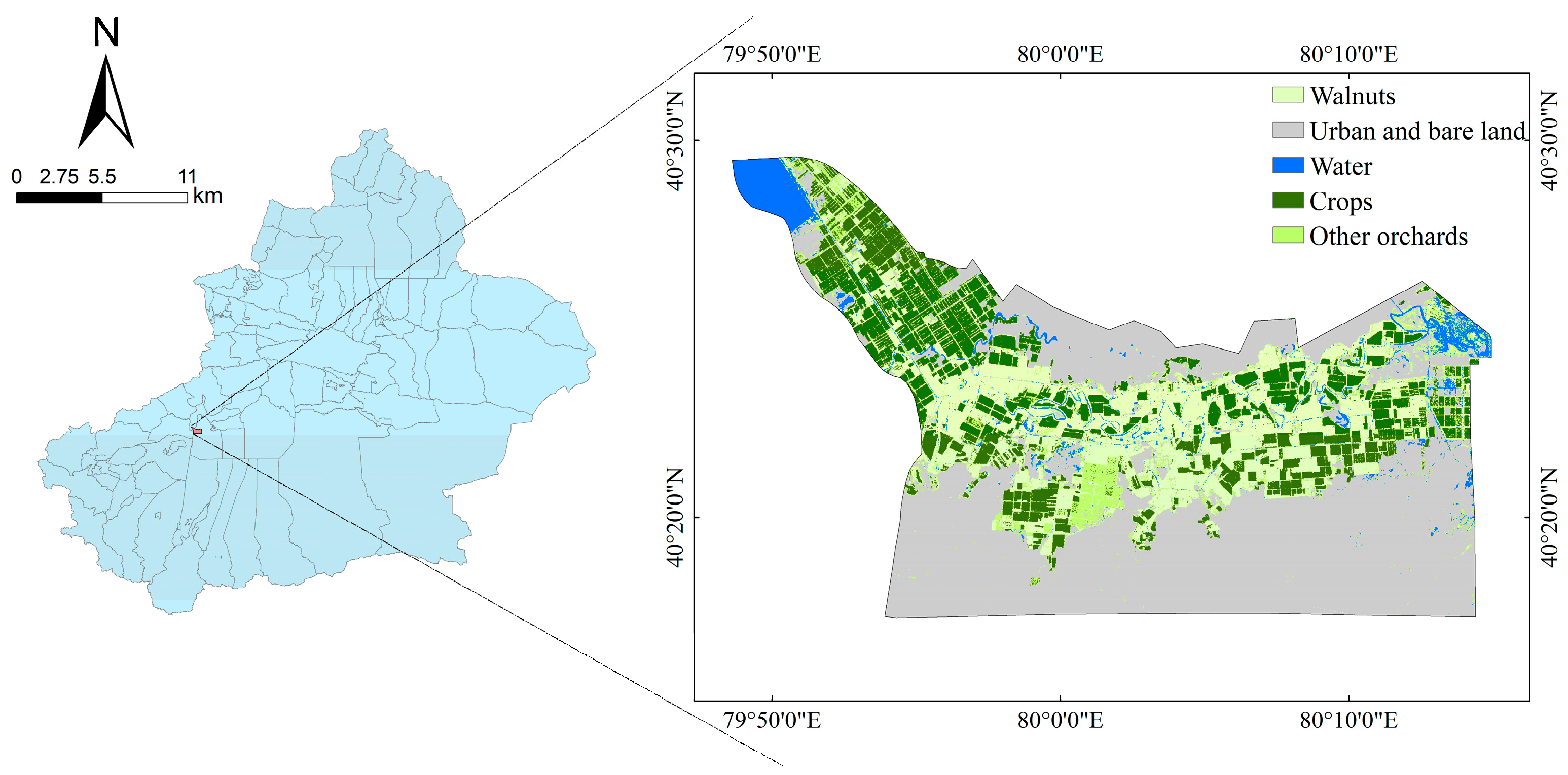
2.1.1. Overview of the Research Area
2.1.2. Image Data Set and Preprocessing
2.1.3. Basis of Sample Data and Authentication Data
2.2. Research Methods
2.2.1. Technical Process
2.2.2. Information Acquisition of the Walnut Planting Area
2.2.3. Walnut Growth Information Extraction
2.2.4. Accuracy Verification
3. Results
3.1. Area Monitoring Results
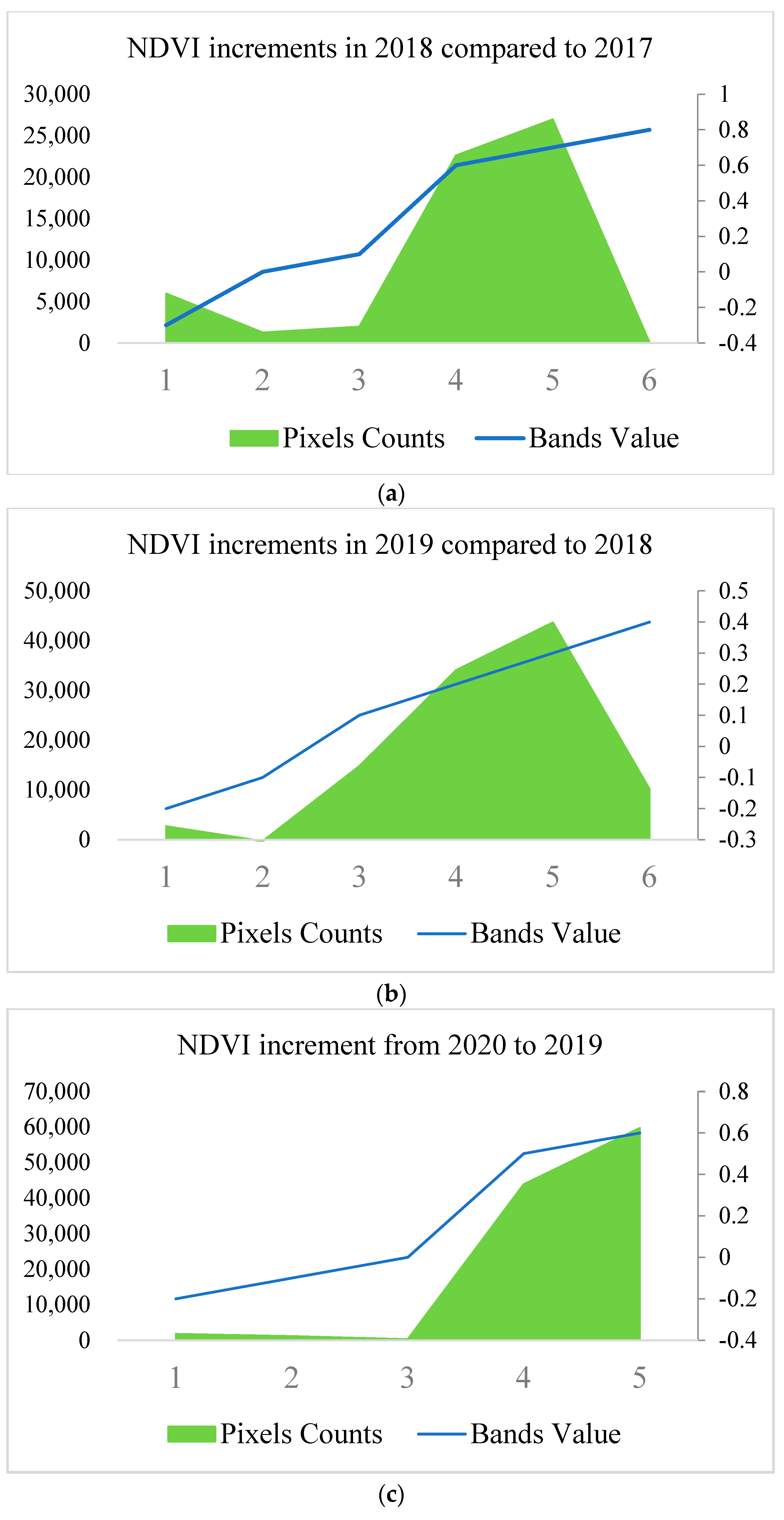
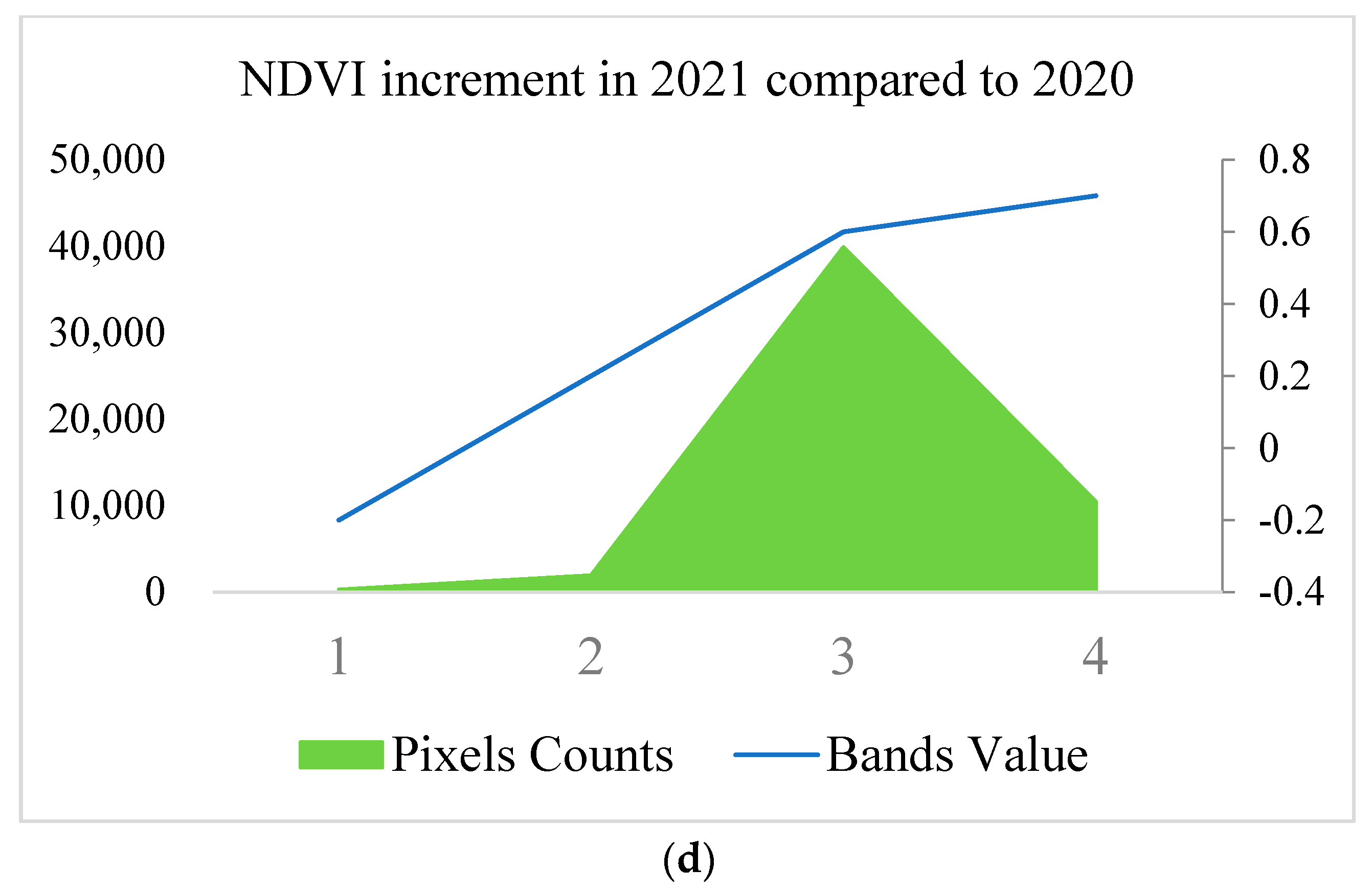
3.2. Growth Monitoring Results
4. Discussion
4.1. Accuracy Evaluation on the Extraction of Walnut Planting Areas in the Research Area
4.2. Remote Sensing Monitoring of Walnut Planting in the Research Area
5. Conclusions
Author Contributions
Funding
Institutional Review Board Statement
Informed Consent Statement
Data Availability Statement
Acknowledgments
Conflicts of Interest
References
- Chen, L.; Ma, Q.; Chen, Y.; Wang, B.; Pei, D. Identification of major walnut cultivars grown in China based on nut phenotypes and SSR markers. Sci. Hortic. 2014, 168, 240–248. [Google Scholar] [CrossRef]
- Huang, Q.; Tang, H.; Zhou, Q.; Wu, W.; Wang, L.; Zhang, L. Remote-sensing based monitoring of planting structure and growth condition of major crops in Northeast China. Trans. Chin. Soc. Agric. Eng. 2010, 26, 218–223. [Google Scholar]
- Genovese, G.; Vignolles, C.; Nègre, T.; Passera, G. A methodology for a combined use of normalised difference vegetation index and CORINE land cover data for crop yield monitoring and forecasting. A case study on Spain. Agronomie 2001, 21, 91–111. [Google Scholar] [CrossRef]
- Rojas, O. Operational maize yield model development and validation based on remote sensing and agro-meteorological data in Kenya. Int. J. Remote Sens. 2007, 28, 3775–3793. [Google Scholar] [CrossRef]
- Torres-Sánchez, J.; López-Granados, F.; Pena, J.M. An automatic object-based method for optimal thresholding in UAV images: Application for vegetation detection in herbaceous crops. Comput. Electron. Agric. 2015, 114, 43–52. [Google Scholar] [CrossRef]
- Zhang, J.; Feng, L.; Yao, F. Improved maize cultivated area estimation over a large scale combining MODIS–EVI time series data and crop phenological information. ISPRS J. Photogramm. Remote Sens. 2014, 94, 102–113. [Google Scholar] [CrossRef]
- Chen, Y.; Lu, D.; Moran, E.; Batistella, M.; Dutra, L.V.; Sanches, I.D.A.; da Silva, R.F.B.; Huang, J.; Luiz, A.J.B.; de Oliveira, M.A.F. Mapping croplands, cropping patterns, and crop types using MODIS time-series data. Int. J. Appl. Earth Obs. Geoinf. 2018, 69, 133–147. [Google Scholar] [CrossRef]
- Zhang, X.; Liu, K.; Wang, S.; Long, X.; Li, X. A Rapid Model (COV_PSDI) for Winter Wheat Mapping in Fallow Rotation Area Using MODIS NDVI Time-Series Satellite Observations: The Case of the Heilonggang Region. Remote Sens. 2021, 13, 4870. [Google Scholar] [CrossRef]
- Arvor, D.; Jonathan, M.; Meirelles, M.S.P.; Dubreuil, V.; Durieux, L. Classification of MODIS EVI time series for crop mapping in the state of Mato Grosso, Brazil. Int. J. Remote Sens. 2011, 32, 7847–7871. [Google Scholar] [CrossRef]
- Zheng, B.; Myint, S.W.; Thenkabail, P.S.; Aggarwal, R.M. A support vector machine to identify irrigated crop types using time-series Landsat NDVI data. Int. J. Appl. Earth Obs. Geoinf. 2015, 34, 103–112. [Google Scholar] [CrossRef]
- Löw, F.; Michel, U.; Dech, S.; Conrad, C. Impact of feature selection on the accuracy and spatial uncertainty of per-field crop classification using support vector machines. ISPRS J. Photogramm. Remote Sens. 2013, 85, 102–119. [Google Scholar] [CrossRef]
- Lebourgeois, V.; Dupuy, S.; Vintrou, É.; Ameline, M.; Butler, S.; Bégué, A. A combined random forest and OBIA classification scheme for mapping smallholder agriculture at different nomenclature levels using multisource data (simulated Sentinel-2 time series, VHRS and DEM). Remote Sens. 2017, 9, 259. [Google Scholar] [CrossRef]
- Long, J.A.; Lawrence, R.L.; Greenwood, M.C.; Marshall, L.; Miller, P.R. Object-oriented crop classification using multitemporal ETM+ SLC-off imagery and random forest. GISci. Remote Sens. 2013, 50, 418–436. [Google Scholar] [CrossRef]
- Oliphant, A.J.; Thenkabail, P.S.; Teluguntla, P.; Xiong, J.; Gumma, M.K.; Congalton, R.G.; Yadav, K. Mapping cropland extent of Southeast and Northeast Asia using multi-year time-series Landsat 30-m data using a random forest classifier on the Google Earth Engine Cloud. Int. J. Appl. Earth Obs. Geoinf. 2019, 81, 110–124. [Google Scholar] [CrossRef]
- Breiman, L. Random forests. Mach. Learn. 2001, 45, 5–32. [Google Scholar] [CrossRef]
- Dong, C.; Zhao, G.; Qin, Y.; Wan, H. Area extraction and spatiotemporal characteristics of winter wheat–summer maize in Shandong Province using NDVI time series. PLoS ONE 2019, 14, e0226508. [Google Scholar] [CrossRef]
- Gorelick, N.; Hancher, M.; Dixon, M.; Ilyushchenko, S.; Thau, D.; Moore, R. Google Earth Engine: Planetary-scale geospatial analysis for everyone. Remote Sens. Environ. 2017, 202, 18–27. [Google Scholar] [CrossRef]
- Shelestov, A.; Lavreniuk, M.; Kussul, N.; Novikov, A.; Skakun, S. Exploring Google Earth Engine platform for big data processing: Classification of multi-temporal satellite imagery for crop mapping. Front. Earth Sci. 2017, 5, 17. [Google Scholar] [CrossRef]
- Jin, Z.; Azzari, G.; You, C.; Di Tommaso, S.; Aston, S.; Burke, M.; Lobell, D.B. Smallholder maize area and yield mapping at national scales with Google Earth Engine. Remote Sens. Environ. 2019, 228, 115–128. [Google Scholar] [CrossRef]
- Yuping, M.; Shili, W.; Li, Z.; Yingyu, H.; Liwei, Z.; Yanbo, H.; Futang, W. Monitoring winter wheat growth in North China by combining a crop model and remote sensing data. Int. J. Appl. Earth Obs. Geoinf. 2008, 10, 426–437. [Google Scholar] [CrossRef]
- Pan, L.; Xia, H.; Zhao, X.; Guo, Y.; Qin, Y. Mapping winter crops using a phenology algorithm, time-series Sentinel-2 and Landsat-7/8 images, and Google Earth Engine. Remote Sens. 2021, 13, 2510. [Google Scholar] [CrossRef]
- Tian, F.; Wu, B.; Zeng, H.; Zhang, X.; Xu, J. Efficient identification of corn cultivation area with multitemporal synthetic aperture radar and optical images in the google earth engine cloud platform. Remote Sens. 2019, 11, 629. [Google Scholar] [CrossRef]
- Dong, J.; Xiao, X.; Menarguez, M.A.; Zhang, G.; Qin, Y.; Thau, D.; Biradar, C.; Moore, B., III. Mapping paddy rice planting area in northeastern Asia with Landsat 8 images, phenology-based algorithm and Google Earth Engine. Remote Sens. Environ. 2016, 185, 142–154. [Google Scholar] [CrossRef] [PubMed]
- Drusch, M.; Del Bello, U.; Carlier, S.; Colin, O.; Fernandez, V.; Gascon, F.; Hoersch, B.; Isola, C.; Laberinti, P.; Martimort, P. Sentinel-2: ESA’s optical high-resolution mission for GMES operational services. Remote Sens. Environ. 2012, 120, 25–36. [Google Scholar] [CrossRef]
- Belgiu, M.; Csillik, O. Sentinel-2 cropland mapping using pixel-based and object-based time-weighted dynamic time warping analysis. Remote Sens. Environ. 2018, 204, 509–523. [Google Scholar] [CrossRef]
- Tachiiri, K. Calculating NDVI for NOAA/AVHRR data after atmospheric correction for extensive images using 6S code: A case study in the Marsabit District, Kenya. ISPRS J. Photogramm. Remote Sens. 2005, 59, 103–114. [Google Scholar] [CrossRef]
- Oetter, D.R.; Cohen, W.B.; Berterretche, M.; Maiersperger, T.K.; Kennedy, R.E. Land cover mapping in an agricultural setting using multiseasonal Thematic Mapper data. Remote Sens. Environ. 2001, 76, 139–155. [Google Scholar] [CrossRef]
- Mohanaiah, P.; Sathyanarayana, P.; GuruKumar, L. Image texture feature extraction using GLCM approach. Int. J. Sci. Res. Publ. 2013, 3, 1–5. [Google Scholar]
- Hossain, E.; Hossain, M.F.; Rahaman, M.A. A color and texture based approach for the detection and classification of plant leaf disease using KNN classifier. In Proceedings of the 2019 International Conference on Electrical, Computer and Communication Engineering (ECCE), Chittagong, Bangladesh, 7–9 February 2019; pp. 1–6. [Google Scholar]
- Wang, J.; Tian, H.; Wu, M.; Wang, L.; Wang, C. Rapid mapping of winter wheat in Henan Province. J. Geo-Inf. Sci. 2017, 19, 846–853. [Google Scholar]
- Ok, A.O.; Akar, O.; Gungor, O. Evaluation of random forest method for agricultural crop classification. Eur. J. Remote Sens. 2012, 45, 421–432. [Google Scholar] [CrossRef]
- Saini, R.; Ghosh, S.K. Crop classification on single date sentinel-2 imagery using random forest and suppor vector machine. Int. Arch. Photogramm. Remote Sens. Spat. Inf. Sci. 2018, 42, 683–688. [Google Scholar] [CrossRef]
- Nitze, I.; Schulthess, U.; Asche, H. Comparison of machine learning algorithms random forest, artificial neural network and support vector machine to maximum likelihood for supervised crop type classification. In Proceedings of the 4th GEOBIA, Rio de Janeiro, Brazil, 7–9 May 2012; Volume 79, p. 3540. [Google Scholar]
- Jiang, Z.; Huete, A.R.; Didan, K.; Miura, T. Development of a two-band enhanced vegetation index without a blue band. Remote Sens. Environ. 2008, 112, 3833–3845. [Google Scholar] [CrossRef]
- Gandhi, G.M.; Parthiban, B.; Thummalu, N.; Christy, A. Ndvi: Vegetation change detection using remote sensing and gis—A case study of Vellore District. Procedia Comput. Sci. 2015, 57, 1199–1210. [Google Scholar] [CrossRef]
- Kumar, L.; Mutanga, O. Google Earth Engine applications since inception: Usage, trends, and potential. Remote Sens. 2018, 10, 1509. [Google Scholar] [CrossRef]
- Liu, L.; Xiao, X.; Qin, Y.; Wang, J.; Xu, X.; Hu, Y.; Qiao, Z. Mapping cropping intensity in China using time series Landsat and Sentinel-2 images and Google Earth Engine. Remote Sens. Environ. 2020, 239, 111624. [Google Scholar] [CrossRef]
- Cao, J.; Zhang, Z.; Luo, Y.; Zhang, L.; Zhang, J.; Li, Z.; Tao, F. Wheat yield predictions at a county and field scale with deep learning, machine learning, and google earth engine. Eur. J. Agron. 2021, 123, 126204. [Google Scholar] [CrossRef]


| Month | Growth Period of Walnuts |
|---|---|
| Between April and June | Fruit development period |
| July | Hardcore period |
| Aug | Oil conversion period |
| Mid-September | Mature period |
| Year | Data | Filter Cloud Amount | Number of Images |
|---|---|---|---|
| 2017–2018 | 1 April to 1 July | <20% | 18 |
| 1 July to 15 September | <20% | 13 | |
| 2018–2019 | 1 April to 1 July | <20% | 18 |
| 1 July to 15 September | <20% | 13 | |
| 2019–2020 | 1 April to 1 July | <10% | 18 |
| 1 July to 15 September | <10% | 13 | |
| 2020–2021 | 1 April to 1 July | <10% | 18 |
| 1 July to 15 September | <10% | 13 |
| Specimen Type | Interpretation Signs | Description |
|---|---|---|
| Impervious surface |  | The impervious surfaces in the study area consist of town buildings, roads, and bare ground, which are identifiable on Google Earth by their texture information and occur in patches. |
| Water |  | The water body area in the study area is mainly composed of reservoirs and rivers, etc. The edges are obvious with respect to texture, and with respect to color, the water body area is cyan and dark cyan. |
| Walnuts |  | The walnuts in the study area are mainly distributed around the area. On Google Earth, the texture is clearer, occurs in patches, exhibits a more regular shape (rectangular), and is dark green in color. |
| Other orchards |  | Other orchards in the study area are mainly located in the rural periphery of the plain zone, exhibiting clearer textures, more regular shapes (rectangular), and light green color in Google Earth. |
| Other crops |  | The study area is also planted with cotton, pepper, wheat, corn, and many other crops in addition to orchards. On Google Earth, it exhibits clearer textures, more regular shapes (rectangles), and bright green color. |
| Classification Feature | Year | Extraction Area (hm2) | Statistical Area (hm2) | Absolute Error (hm2) | The Relative Error (%) |
|---|---|---|---|---|---|
| Spectrum + Terrain + Texture + NDVI | 2017 | 7700 | 8800 | 1100 | 12.5 |
| 2018 | 7000 | 8800 | 1800 | 20.4 | |
| 2019 | 4900 | 5333.3 | 433.3 | 8 | |
| 2020 | 5200 | 5333.3 | 133.3 | 2 | |
| 2021 | 4600 | 5333.3 | 733.3 | 13 | |
| Spectrum + Topography + Texture + NDVI + EVI | 2017 | 7700 | 8800 | 1100 | 12.5 |
| 2018 | 7000 | 8800 | 1800 | 20.4 | |
| 2019 | 5000 | 5333.3 | 333.3 | 6 | |
| 2020 | 5400 | 5333.3 | 66.7 | 1 | |
| 2021 | 4700 | 5333.3 | 633.3 | 11 |
| Classification Feature | Year | Overall Accuracy (%) | Kappa (%) | Walnut Classification Accuracy (%) |
|---|---|---|---|---|
| Spectrum + Terrain + Texture + NDVI | 2017 | 89.95 | 86.75 | 92.40 |
| 2018 | 90.43 | 87.41 | 90.90 | |
| 2019 | 93.29 | 90.70 | 89.41 | |
| 2020 | 94.47 | 92.38 | 88.37 | |
| 2021 | 94.47 | 92.40 | 92.77 | |
| Spectrum + Topography + Texture + NDVI + EVI | 2017 | 89.95 | 86.84 | 94.66 |
| 2018 | 91.38 | 88.65 | 92.30 | |
| 2019 | 93.29 | 90.72 | 89.28 | |
| 2020 | 95.02 | 93.11 | 89.53 | |
| 2021 | 94.50 | 92.40 | 92.80 |
Disclaimer/Publisher’s Note: The statements, opinions and data contained in all publications are solely those of the individual author(s) and contributor(s) and not of MDPI and/or the editor(s). MDPI and/or the editor(s) disclaim responsibility for any injury to people or property resulting from any ideas, methods, instructions or products referred to in the content. |
© 2023 by the authors. Licensee MDPI, Basel, Switzerland. This article is an open access article distributed under the terms and conditions of the Creative Commons Attribution (CC BY) license (https://creativecommons.org/licenses/by/4.0/).
Share and Cite
Shi, Z.; Zhang, R.; Bai, T.; Li, X. Walnut Acreage Extraction and Growth Monitoring Based on the NDVI Time Series and Google Earth Engine. Appl. Sci. 2023, 13, 5666. https://doi.org/10.3390/app13095666
Shi Z, Zhang R, Bai T, Li X. Walnut Acreage Extraction and Growth Monitoring Based on the NDVI Time Series and Google Earth Engine. Applied Sciences. 2023; 13(9):5666. https://doi.org/10.3390/app13095666
Chicago/Turabian StyleShi, Ziyan, Rui Zhang, Tiecheng Bai, and Xu Li. 2023. "Walnut Acreage Extraction and Growth Monitoring Based on the NDVI Time Series and Google Earth Engine" Applied Sciences 13, no. 9: 5666. https://doi.org/10.3390/app13095666
APA StyleShi, Z., Zhang, R., Bai, T., & Li, X. (2023). Walnut Acreage Extraction and Growth Monitoring Based on the NDVI Time Series and Google Earth Engine. Applied Sciences, 13(9), 5666. https://doi.org/10.3390/app13095666


