Abstract
Low earth orbit (LEO) mega-constellations have once again triggered a wave of space-based system construction. On the one hand, LEO communication, LEO navigation, LEO remote sensing constellations and so on are proposed. On the other hand, with the continuous development of software-defined satellite and intelligent satellite technology, space-based systems are developing in the direction of multi-function, integration and cross-domain integration. The whole space-based system is no longer the traditional working mode of a single functional constellation, but a genral cross-domain fusion constellation (CDFC) system for complex tasks. Like the terrestrial global Internet, the space-based system will serve as a global infrastructure for integrating communication, navigation and remote sensing, that is, the intelligent space-based system, to provide services for the global demand. The traditional method of designing constellation for a certain type of function is no longer applicable to this type of constellation design. To solve this problem, this paper proposes a design and optimization method of cross-domain fusion constellation of communication, navigation and remote sensing based on reverse design. The paper optimizes the CDFC through resource coverage. Through experiments, we prove that the number of satellites in the CDFC can be reduced by 30.60% compared with the independent and combined constellations in each domain, and the coverage and service performance of the constellation can be improved. The cost can be reduced by 18.31% compared with the combined constellation. When the same number of satellites is used, the resource coverage of the cross-domain fusion constellation is increased by at least eight times.
1. Introduction
Up to now, the space-based system has been equipped with typical functions such as satellite navigation, communication, remote sensing, GPS, Starlink and Skysat. However, these constellations are single-function systems and can only provide a certain kind of service. They are called domains, which are defined as systems that can complete specific functions according to certain rules, such as navigation, including a set of connected devices and user terminals [1]. If the resources of various domains (such as the communication domain and remote sensing domain) can be coordinated, the network performance can be significantly enhanced [2]. With the development of software-definition satellite and intelligent satellite technology, there have been many kinds of cross-domain research on SS in recent years, such as cross-domain resource scheduling [2], communication and navigation integration system [3], integrated SS [4] and even intelligent SS [5]. Integrated cross-domain SS has advantages in improving the utilization of satellite resources and the quality of service. The problem is that the SS needs a more complex design, especially the constellation design, which is the most critical to the performance of the SS.
The CDFC is equivalent to the constellation system with multifunctional domain fusion together, which brings difficulties to constellation design, such as uncertainty of satellite functions, explosion of computing space, mutual coupling of system variables, etc. [6,7,8,9,10,11,12,13,14]. CDFCs are different from hybrid constellations. Hybrid constellations are aimed to improve services by optimizing orbits [6] to meet different user needs [7] or different coverage requirements [8]. They all discuss service optimization in the same functional domain, while CDFCs need to consider multiple functional domains. Wang et al. presented a special case of an integrated constellation based on coverage characteristics for the comprehensive application requirements of communication, navigation and remote sensing [9]. For CDFC, it is necessary to consider the parameters of each functional domain and their relationship more comprehensively. It is a multi-objective fusion design problem [10]. In traditional multi-objective constellation design, simplex algorithm [11] and semi-analytical method [12] intelligent algorithms such as genetic algorithm [3,13], multidisciplinary design optimization (MDO) method [10,14] and so on are widely used. The problem with the above algorithms is that CDFC cannot directly use analytical expressions. The genetic algorithm is only applied to a single discipline or field. The multidisciplinary design optimization method is a method to solve the dynamic influence of multidisciplinary methods in complex engineering system design and realize the system optimization design. However, when this method is used in constellation design, and is different disciplines in a single domain, such as structure and orbit dynamics [14]. Based on the above challenges, we put forward the concept of CDFC and the design method of multidisciplinary collaborative reverse optimization (MDCRO). The contributions of this paper are summarized as:
- A concept of CDFC based on software-defined satellite for communication, navigation, remote sensing and other different functional domains is proposed.
- In order to design the constellation, a constellation design method is proposed to optimize the CDFC based on resource coverage after combining the constellations in different domains.
- Through simulation and comparison, the advantages of CDFC in terms of satellite number and cost are verified.
This paper is organized as follows. Section 1 introduces the development trend of integrated cross-domain integration at home and abroad, and the research status of constellation design and optimization. Section 2 introduces the integrated constellation design and optimization method based on reverse design and the two-stage algorithm adopted. Section 3 introduces the experimental content and result analysis. Finally, Section 4 gives the conclusion of this paper, and describes the limitations of this study and future research directions.
2. Cross-Domain Fusion Constellation Design Method
The CDFC design method based on MDCRO divides constellation design into two stages: basic constellation design and constellation reverse fusion optimization. Traditional constellation design is generally aimed at a single business, such as the design of dedicated navigation constellation and remote sensing constellation. In order to effectively adopt the traditional constellation design method, in the first stage, the multidisciplinary collaborative design optimization method is used for each domain to obtain the constellation that meets the requirements of each task. After entering the reverse design stage, the satellite is eliminated according to the requirements, and the optimized constellation scheme is solved. Section 2.1 first introduces the requirements and design methods, and Section 2.2 describes the process of the two stages in detail.
2.1. Constellation Design Scheme
Constellation design refers to the simultaneous design of multiple satellite tasks to jointly complete a specific task, generally including satellite type, number, working orbit, etc. This is for the traditional single-domain constellation design.The CDFC is a multi-domain universal constellation, and its completed tasks are no longer limited to one category. Communication, navigation and remote sensing are the typical domains in this paper. First, it is necessary to analyze the system requirements and constraints of the constellation. The requirements of each domain should be merged as much as possible, and those that cannot be merged should be designed separately. Then, it is necessary to give the constraint conditions of the corresponding payload. Though the satellite of CDFC can define satellite functions through software in orbit, it is constrained by the payload carried by the satellite itself. The third step is to set the basic parameter constraints of the constellation, such as orbit height, orbit inclination, etc. If the accurate value cannot be determined, the approximate limit range can be given. Based on the above inputs, we carry out a multidisciplinary constellation design to obtain the basic constellation of each functional domain, and then conduct a comprehensive design. Roughly removing the satellite is the first step during a synthesis. Then, in the reverse design phase, optimize the deployment position of the payload first, and then make the satellite fusion. After reverse optimization based on constraints, the final target constellation is finished.
2.2. Basic Constellation Design
2.2.1. Communication Constellation Generation Method
In ultra-dense low earth orbit (LEO) satellite ground communications, users are more concerned about the communication backhaul capacity, which reflects the service quality obtained by users. Therefore, the main indicators of the communication constellation consider the communication backhaul capacity of the user terminal. Assuming there are k user terminals, u in the satellite coverage area, the communication capacity R of each user terminal is [15].
B, P, , I are signal bandwidth, power signal, white Gaussian noise and interference, respectively. For each user terminal, if there are m satellites covering the area, the service capacity obtained by the user terminal is
We use the typical LEO polar orbit constellation as the initial constellation, and the paper [15] demonstrates the coverage advantage of the polar orbit constellation in communication through verification. The design goal of the communication domain is to use as few satellites as possible and cover as many ground users as possible on the premise of meeting the requirements of the communication backhaul capacity .
The above constraints indicate that the communication backhaul capacity is larger than the constraint requirements. Refer to the paper [16], and the coverage area should exceed 95%.
2.2.2. Navigation Constellation Generation Method
LEO navigation enhancement is to improve the accuracy, integrity and space-based monitoring capability of existing satellite navigation systems by using LEO constellation. The independent navigation mode is adopted in the navigation domain adopts, and the available navigation accuracy factor, geometric dilution of precision (GDOP) is taken as the main index. The mixed orbit designs of inclined orbit and polar orbit will be used [17]. Since only LEO satellites in the independent navigation mode are considered, the paper only considers LEO constellation, and the form of the weight matrix of GDOP can be described as follows [17].
In (4), n refers to the number of visible satellites in the LEO constellation, and , respectively, refer to the LEO satellite position vector and user position vector under the Earth Centered Earth Fixed coordinate system. Generally speaking, good navigation and positioning performance can be obtained when [16]. The calculation of global GDOP is as follows [17].
The above constraint means that the navigation resources in CDFC should be at least four times the coverage; where T is the constellation design planning period, and and distribution are the division of longitude and latitude of the earth grid.
2.2.3. Remote Sensing Constellation Generation Method
The remote sensing constellation generally focuses on its coverage area and observation resolution. Assuming that the satellite orbit height is h, the Earth’s radius is , the angle of view of the satellite payload is , the ground coverage width is L, and a is a semi-major axis, the formula for calculating the satellite coverage is as follows.
L is the area covered by a single satellite to the Earth. To achieve a single global coverage, the sum of all satellite coverage areas in the constellation is generally twice the total area of the ground [16]. Therefore, the coverage area of the remote sensing payload needs to be doubled. The spatial resolution of remote sensing payload, , is related to the instantaneous field of view and orbit height, as shown in (9).
In (9), is related to the sensor size and load focus, and its performance quality is related to the components. As can be seen from Equation (9), the lower the orbit, the higher the resolution that can be obtained. The field angle of remote sensing payload is constrained within the range of , and the coverage constraint is shown in (10). Therefore, the optimization of the number of satellites and the orbit altitude are also involved.
The constraint of formula (10) represents the coverage and detection resolution of remote sensing constellation.
2.2.4. Constellation Fusion Based on Collaborative Optimization
Based on the MDO method of collaborative optimization (CO), the basic constellation of navigation, communication, remote sensing and other functional domains can be constructed into a comprehensive constellation. In this paper, CO is divided into general parameters and special parameters for optimization [14]. The multidisciplinary optimization structure of hierarchical collaborative optimization is shown in Figure 1. General design variables are shared by subproblems of each functional domain, and participate in the design optimization process of each subproblem. Special parameters are optimized only in their respective functional areas. As the integrated CDFC spans the fields of communication, navigation and remote sensing, this paper adopts a unified method based on cost measurement to measure the system parameters uniformly.
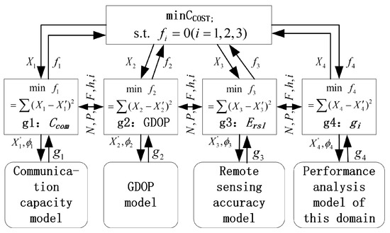
Figure 1.
Structure diagram of multidisciplinary collaborative design for CDFC.
In the synthesis, the cost of CDFC mainly considers the number of satellites and the composition of a single satellite’s cost. The cost of a single satellite mainly considers the cost of the basic platform and payloads of the satellite [18].
In (11), and are the costs of satellite platforms and payloads, respectively. One satellite and one platform are presumed, but the number of payloads will be determined later according to the optimized payload deployment. Due to the limitation of satellite volume and power consumption, the configuration that no more than three payloads in a satellite are set. The optimization model established is as follows. The existing objective functions of each domain in Figure 1, namely , , and , are not repeated.
The constraint in (12) mean that the left side of the inequality should be as close to zero as possible. In the experiment of this paper, after several tests, the convergence effect is better when the value of Algorithm 1 is 0.001.
If there are other functional domain designs, they can also be represented by and participate in the constellation design. This method does not limit the number of subjects involved in CO. This paper only focuses on the design optimization of the most common communication, navigation and remote sensing domains.
The satellite of the cross-domain fusion constellation must be a software-defined satellite capable of carrying different loads, or even an intelligent satellite capable of autonomous mission planning. Only in this way can the functions of satellites be redefined and realized according to the mission requirements, which is the basis and key of cross-domain fusion constellation. This kind of satellite allows the space-based system to maximize the use of resources in space and time through mission planning and function reconstruction within the entire constellation system, avoiding the shortcoming that traditional constellations can only work in a specific space orbit.
Combining the design structure of Figure 1 with the design of various disciplines, the MDRCO algorithm is shown in Algorithm 1. According to the design requirements of the three functional domain constellations input, under the common domain shared design goal, the initial design variables are gradually optimized and converged, and the initial fusion constellation is finally output.
| Algorithm 1 Multidisciplinary collaborative optimization. |
|
3. Constellation Optimization Design
3.1. Resource Coverage
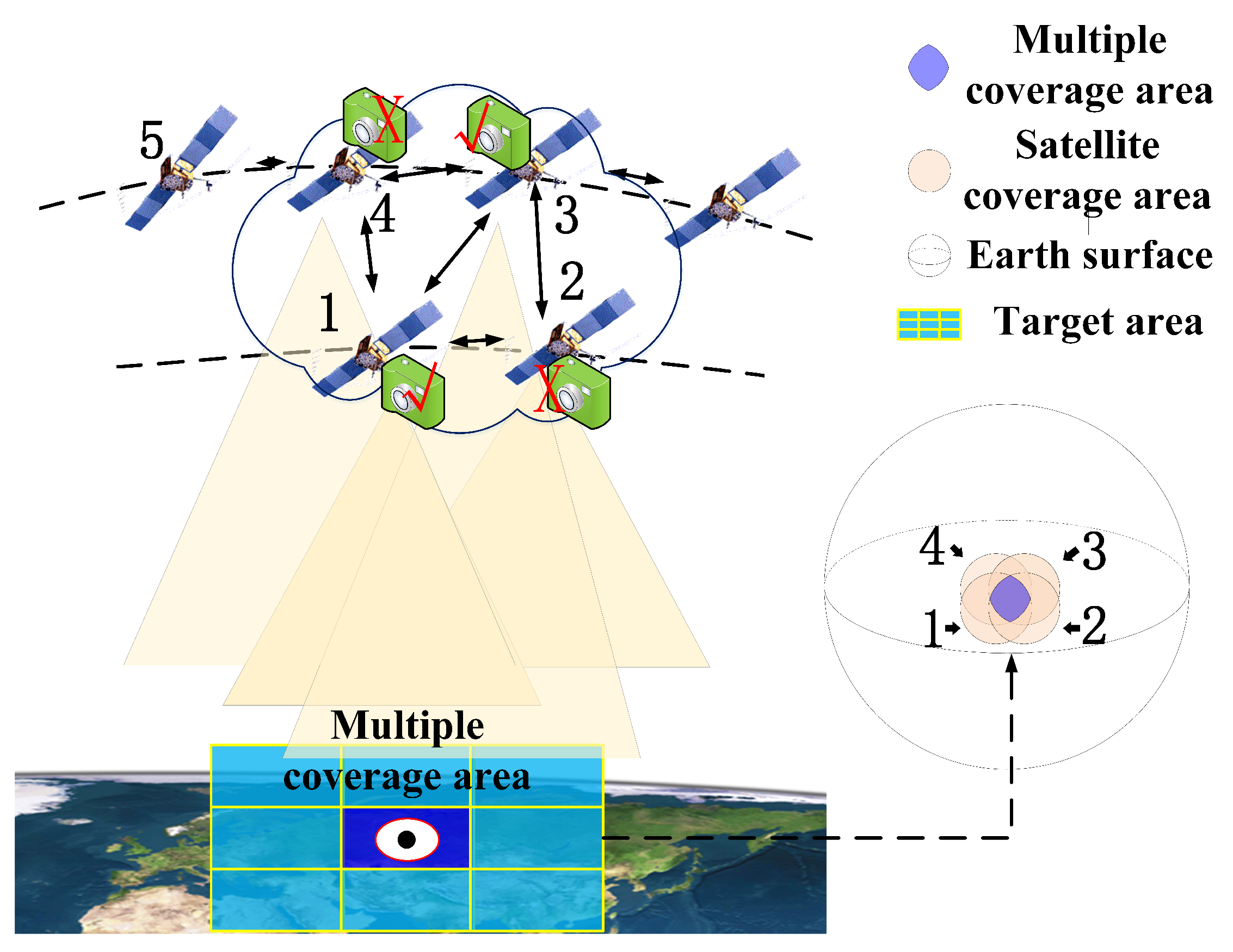
Based on Section 2.2, we have obtained a comprehensive basic constellation. The basic constellation is the result of multidisciplinary collaborative design optimization. In the process of optimization, it is necessary to take into account the needs of each sub-functional area, and adopt the method of combining requirements, so there must be redundancy. This is mainly embodied in the number of satellites and their sensors. However, this constellation is relatively redundant, so it will be optimized here through reverse fusion optimization. Because of the high orbit density in space, the LEO mega constellation has the advantage of increasing the weight of satellites covering the ground. We hereby give the following definition.
Definition 1.
Point a in an area A, if it is covered by at least k satellites with a certain type of payload resource at time t, then point at that time t is said to be k-covered by resource j. If all points in area A are k-covered by resource j, then area A is said to be k-covered by resource j.
The multiple resource coverages of ultra-dense LEO constellations is a waste of resources, which greatly increases the cost of building CDFC as infrastructure. Therefore, it is possible to optimize the payload deployment according to the requirements. For example, in the case shown in Figure 2, the coverage area has two times of coverage to meet the demand, so the payloads of satellites 2 and 4 can be optimized and deleted. For communication and remote sensing payloads, first, consider the k-covered by the payloads. Here, we directly give a sufficient condition [16] for k-covered, as follows in Lemma 1.

Figure 2.
Multiple resource coverages in the target area.
Lemma 1.
A target area is k-covered by resource j, when the following conditions are met: 1 If two satellites have an intersection; 2 if all intersections are at least k-covered. The coordinates of the intersection point are:
Through this method, the satellite coverage can be converted into the coverage of intersection points, and the multiple coverages of payload resources in each functional area can be solved.
The construction of low orbit mega-constellations has led to more and more satellites. If these constellations are all built, the number of satellites is actually excessive, and the resource coverage is a more multi-layer redundant coverage. Through the satellite function reconstruction and mission planning of the CDFC, the satellites can work together over the same area or between different coverage areas, and unnecessary satellites can be deleted. Therefore, the deployment of satellites and payloads can be optimized through resource coverage to achieve the optimization of CDFC.
3.2. Optimization of Satellite and Payload Deployment
Through the preliminary comprehensive design of the basic constellation, we get a constellation that has been initially optimized but still belongs to the redundant design. The constellation can be further optimized by a fusion reverse optimization algorithm. As mentioned before, the low orbit, a range of 400 to 2000 km, is used in the paper, and one layer of satellites per functional domain is considered. The two-stage reverse design optimization algorithm of constellation synthesis is shown in Algorithm 2. Its main purpose is to get the optimal payload deployment from the satellite cluster visible to the target area, and delete redundant satellites.
Where and are the number of mesh points and load types, respectively. The constellation system is a space-based network that changes with time, but it also has spatial attributes. Therefore, cycle time and divided grid are required for optimization.
is a matrix, which records the payload marks carried by each satellite. The dimension is related to the number of payload types and satellites. The number of payloads carried by each satellite is limited by its power consumption and processing capacity. In the process of load deployment optimization, we are currently considering that each satellite has communication and another load. Communication is the necessary payload for satellite cooperation. It is also possible to carry three kinds of loads, and our design method can also be applied. However, considering the resource capacity of satellites at present, we take each satellite carrying, at most, two kinds of loads for research. The number in line 13 indicates the ith satellite.
| Algorithm 2 Basic constellation reverse optimization. |
|
PAYLOADOPTIME is the optimization algorithm of payload deployment, and the navigation’s sample process is shown in Algorithm 3. It should be noted that we have set a limit on the number of payloads deployed per satellite, as mentioned before. This is to consider the volume and power consumption limitation in actual satellites.
| Algorithm 3 Navigation payload deployment optimization. |
|
The calculation complexity of GDOP is . Since the operation of Algorithm 3 is concentrated on line 3 and line 5, the complexity is . In Algorithm 2, the complexity of line 8 can be obtained from Algorithm 3. Lines 6 are mainly to calculate each intersection point and its coverage or , so the complexity of lines 4–10 in Algorithm 2 is . Where k is the number of resource types, which is a constant. The number of intersected satellites is the number of satellite clusters M. The function of lines 13 in Algorithm 2 is mainly to calculate the three domains’ indicators. The complexity of such calculation is . Therefore, the complexity of the whole algorithm is , which is an acceptable amount of calculation.
4. Experimental Analysis
4.1. Algorithm Implementation
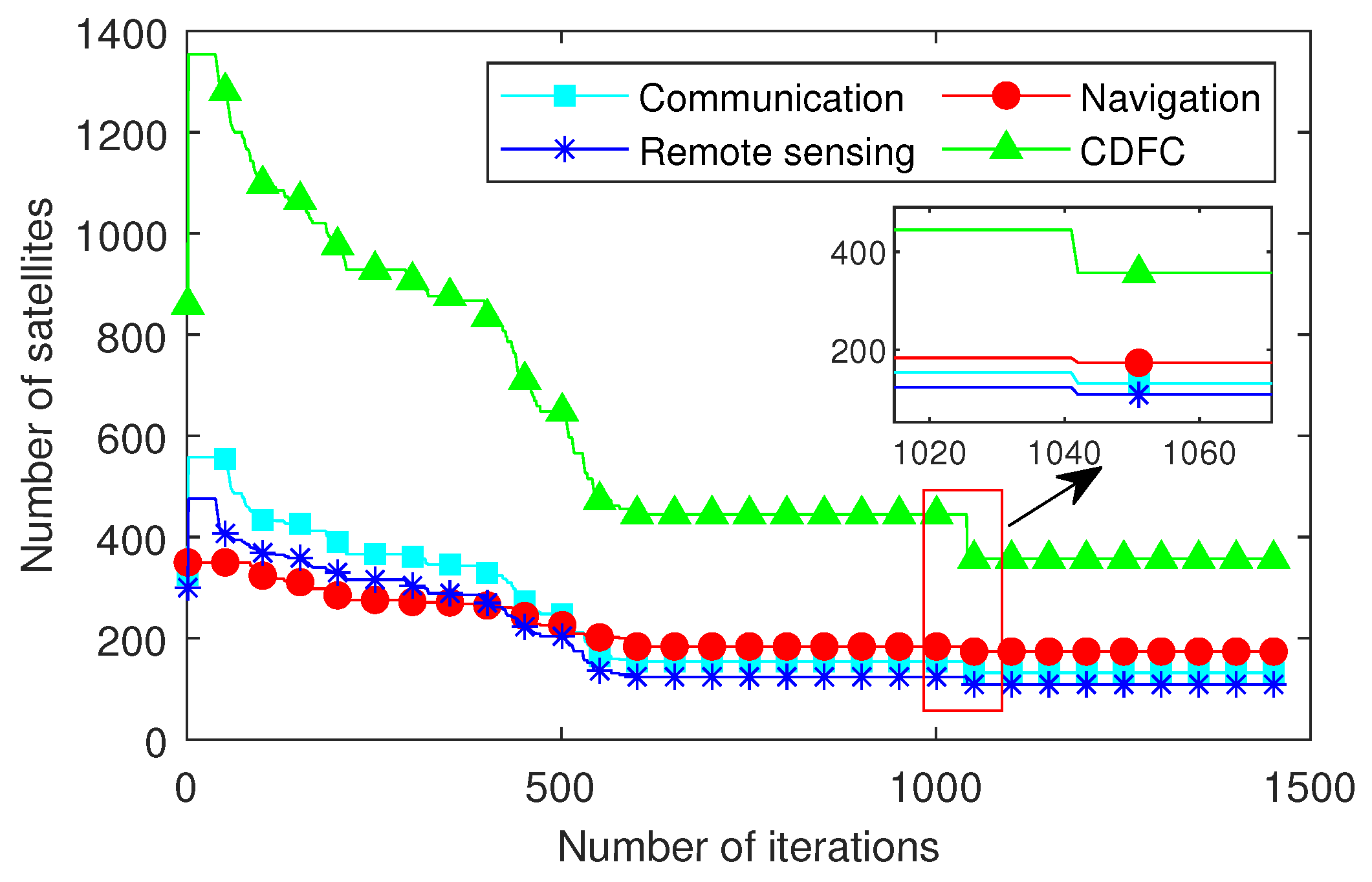
Using the MDCRO proposed in the paper, the convergence process of the number of satellites in the three functional domains and CDFC is shown in Figure 3. The convergence process has obvious two-stage characteristics, and the number of satellites optimized in the second stage is not as large as that in the first stage, because, after MDO with CO, the results have been constrained to a smaller feasible solution range, such as the red oval range in Figure 4. Figure 4 is the pareto front diagram of optimization objectives corresponding to the three functional domains. Under the constraint of meeting the service indicators, the CDFC reduced the number of satellites from 1354 to 347, about a decrease of 73.37%. Since 1354 satellites are initial constellations with redundant values, we can use 451 to compare the average number of constellations in the three functional areas. At this point, the number of satellites has decreased by 23.06%. That is, the result of one third of the 1354 satellites mentioned above and taking an integer, and 1354 satellites are the initial values for the iteration of the three functional domain constellations in Figure 3. It can be used to evaluate the improvement of constellation design optimization. Therefore, it can be seen that it is still a large improvement gain.
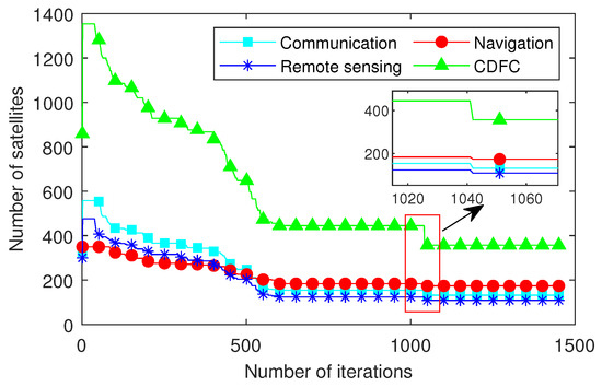
Figure 3.
Convergence process diagram of decision variable optimization.
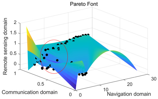
Figure 4.
Pareto front end diagram of three functional domains.
4.2. Constellation Performance
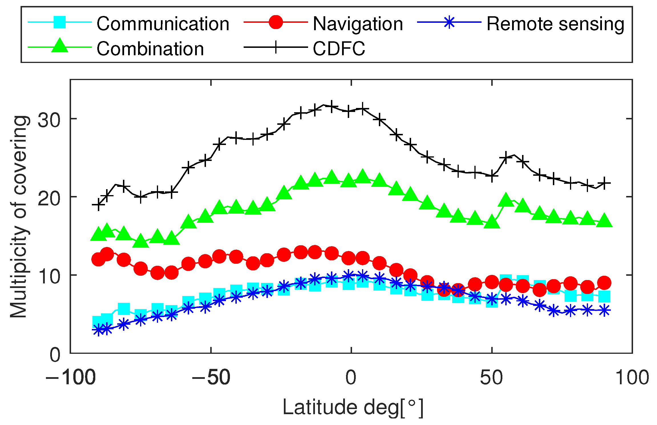
The coverage multiplicity results of constellations in each functional domain and CDFC with latitude are shown in Figure 5. The space simulation software [19] is used to calculate the constellation performance. The constellation and satellite load parameters are the design results of the previous section. The time is 24 h and the time slot is 1 min. The reference [17] in the simulation considers the perturbation of the satellite and other factors, and the setting of the simulation time is to consider that the period has met multiple periods of the satellite within the orbit range of 2000 km. It is worth emphasizing that the CDFC is a hybrid constellation as a whole, and the communication domain is the polar orbit constellation, and the navigation domain is the walker constellation. It can be seen that the coverage multiplicity of the single functional domain constellations is only above 2, and the coverage multiplicity of navigation constellations is higher, all of which meet the requirements of more than 4. Although the single domain coverage multiplicity of communication and remote sensing is small, the CDFC can achieve the lowest coverage multiplicity of 12, with an average coverage multiplicity of 15. Although the coverage weight of the combined constellation is slightly smaller than that of the simple combination constellation, in general, the coverage rate of CDFC with optimized layout and number is not only higher, also relatively average between high and low orbits.
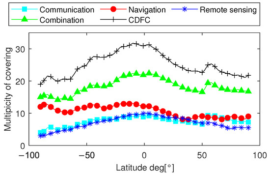
Figure 5.
Constellation coverage map.
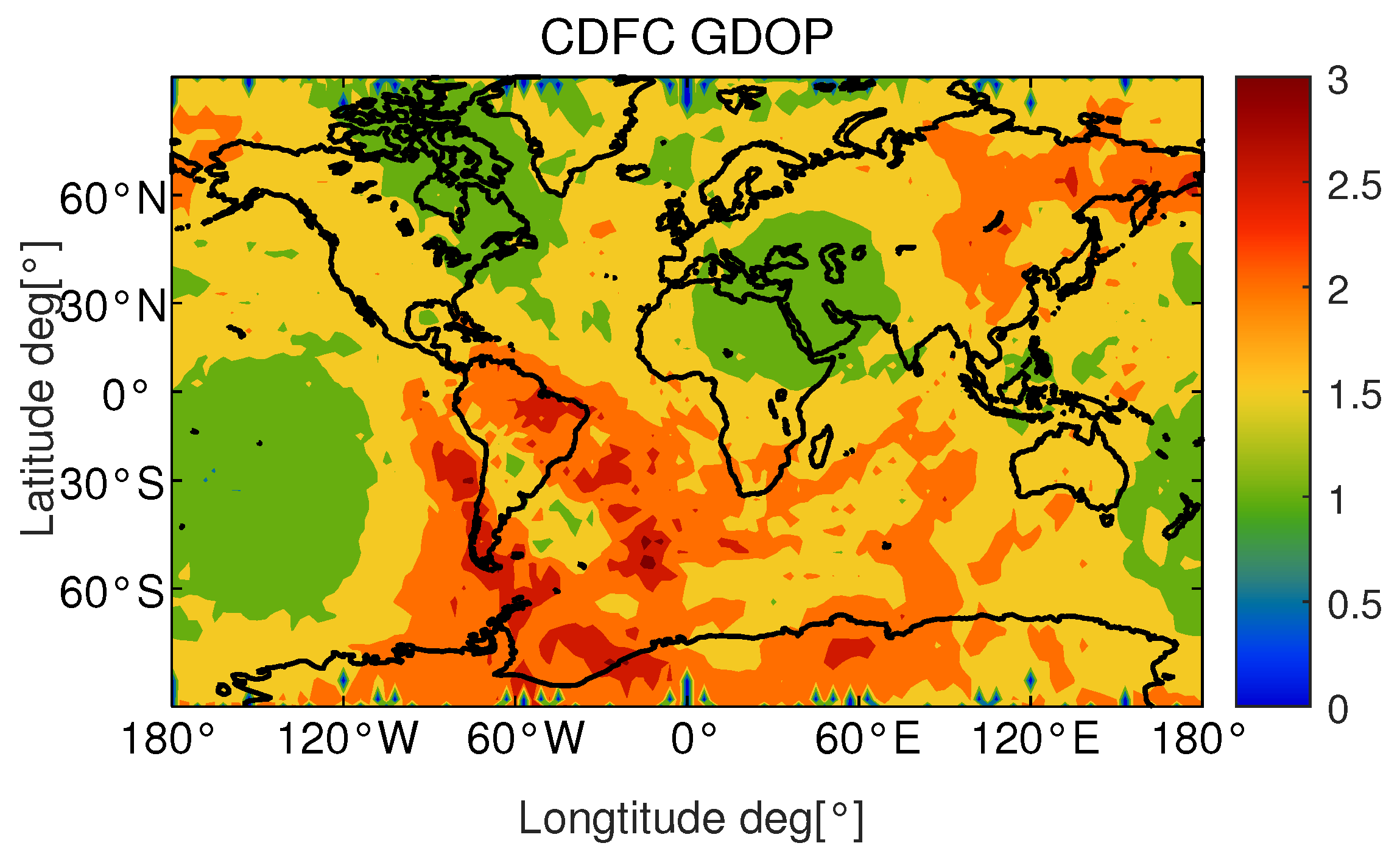
GDOP is for the sake of navigation accuracy, as shown in Figure 6. The global GDOP value of CDFC is within the range of zeros to three, meeting the design index of less than 5. The difference between the navigation payload and remote sensing and communication payload is that the geometric features of navigation payload have an impact on service performance. In order to ensure the geometric configuration, the number of its payload is reduced to less than the other two payloads during the optimization process.
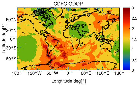
Figure 6.
GDOP of CDFC.
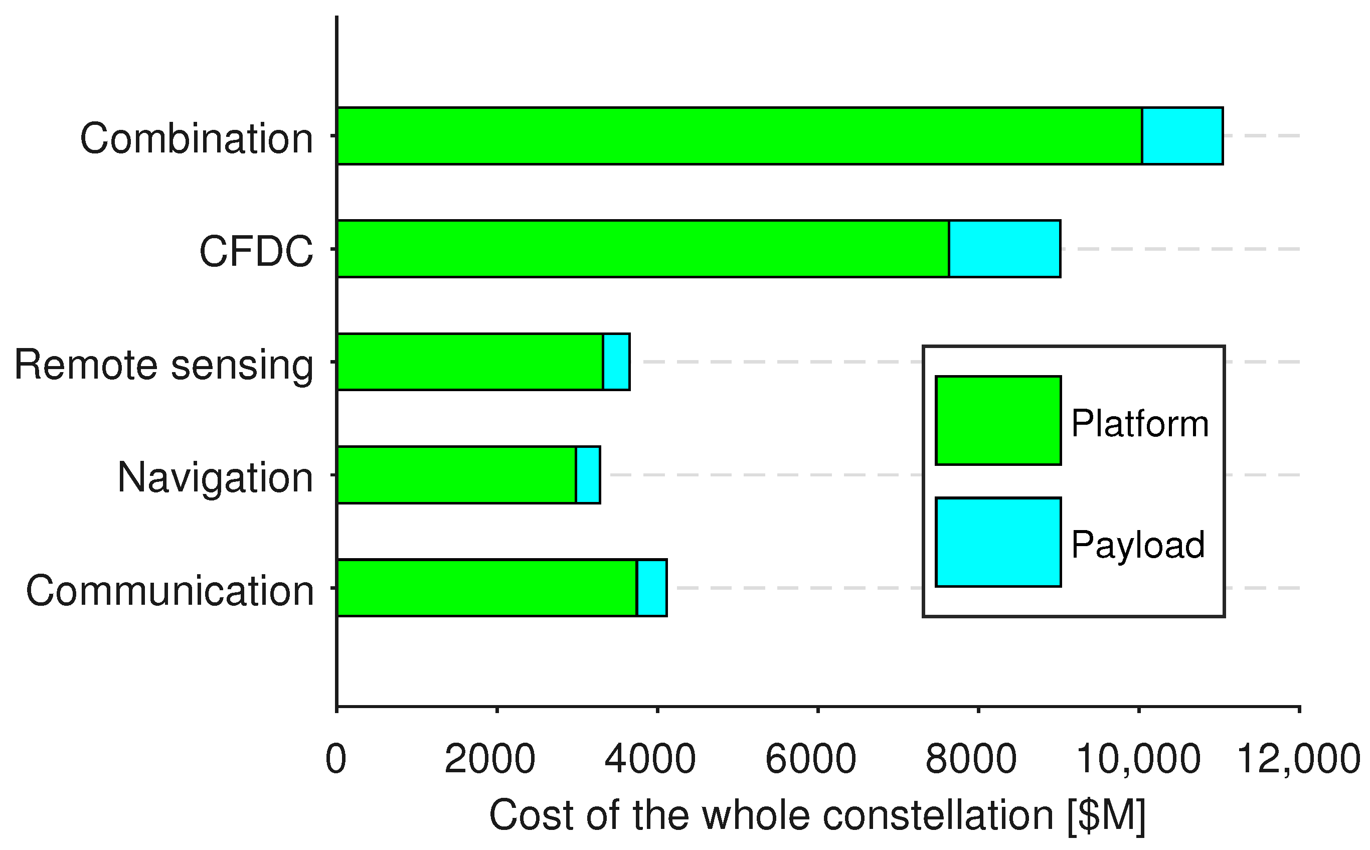
4.3. System Cost
In this letter, the cost of the three basic constellations and the cost of the CDFC are estimated, and the cost model uses formula (11), as shown in Figure 7. Although the cost of the integrated constellation system is higher than three independent constellations, it has significant advantages over the total cost of the three constellations, with a total cost reduction of 18.31%, indicating that the CDFC can effectively reduce costs while maintaining or even exceeding the service quality of the three functional domains.

Figure 7.
Constellation cost.
5. Conclusions
This paper proposes a CDFC design and optimization method for communication, navigation and remote sensing integration based on MDCRO. The CDFC designed by this method can reduce the number of satellites by 23.06% compared with the independent constellations and combined constellations in each domain, the highest can even be about 70%, and improve the coverage and GDOP of the constellation. Compared with the combined constellation, the system cost can be reduced by 18.31%. In this paper, the concept of CDFC proposed by us is verified, which has a good application prospect in the construction of space-based systems and constellation design. In the future research, the paper will combine the distribution of population on the ground, deeply model the needs of users, and design and optimize the CDFC in more detail.
Author Contributions
J.Y. and J.Q.; Methodology, X.G.; Software, X.L.; Validation, J.Q. and X.M.; Formal Analysis, J.Q.; Writing, J.Q.; Supervision, J.Y. and X.G. All authors have read and agreed to the published version of the manuscript.
Funding
This research received no external funding.
Institutional Review Board Statement
Not applicable.
Informed Consent Statement
Not applicable.
Data Availability Statement
Data available on request due to restrictions.
Conflicts of Interest
The authors declare no conflict of interest.
Abbreviations
The following abbreviations are used in this manuscript:
| CDFC | cross-domain fusion constellation |
| MDCRO | multidisciplinary collaborative reverse optimization |
| MDO | multidisciplinary design optimization |
| GDOP | geometric dilution of precision |
| CO | collaborative optimization |
| LEO | low earth orbit |
References
- Boley, A.C.; Byers, M. Satellite mega-constellations create risks in low earth orbit, the atomospere and on earth. Sci. Rep. 2021, 11, 10642. [Google Scholar] [CrossRef] [PubMed]
- Hao, Q.; Sheng, M.; Zhou, D.; Shi, Y. A Multi-Aspect Expanded Hypergraph Enabled Cross-Domain Resource Management in Satellite Networks. IEEE Trans. Commun. 2022, 70, 4687–4701. [Google Scholar] [CrossRef]
- Huang, J.; Liu, Y.; Liu, X.; Ye, X.; Li, X.; Xiao, W.; Liu, W.; Zuo, Y. Optimal Design of LEO Constellation for Communication and Navigation Fusion Based on Genetic Algorithm. Lect. Notes Electr. Eng. 2021, 773, 92–103. [Google Scholar]
- Wang, L.; Meng, J. Constellation Design and Application of Real-Time Space-Based Information Services Supporting Communication, Navigation and Remote Integration. Lect. Notes Electr. Eng. 2021, 654, 1869–1878. [Google Scholar]
- Guariniello, C.; Mockus, L.; Raz, A.K.; DeLaurentis, D.A. Towards Intelligent Architecting of Aerospace System-of-Systems: Part II. In Proceedings of the 2020 IEEE Aerospace Conference, Big Sky, MT, USA, 7–14 March 2020; pp. 1–9. [Google Scholar]
- Palmerini, G. Design of global coverage constellations based on elliptical orbits. In Proceedings of the Astrodynamics Conference, San Diego, CA, USA, 29–31 July 1996. [Google Scholar]
- Chan, S.; Samuels, A.; Shah, N.; Underwood, J.; de Weck, O. Optimization of Hybrid Satellite Constellations Using Multiple Layers and Mixed Circular-Elliptical Orbits. In Proceedings of the 22nd AIAA International Communications Satellite Systems Conference, Monterey, CA, USA, 9–12 May 2004. [Google Scholar]
- Ulybyshev, Y. Satellite Constellations Design for Complex Coverage. J. Spacecr. Rocket. 2008, 45, 843–849. [Google Scholar] [CrossRef]
- Chao, J.; Wen, Y.; Xiaozhou, Z.; Jun, Z.; Yuan, Z. A Multilayer Heterogeneous Constellation Scheme and Minimum Configuration Design Method for Low Rail Communication, Guidance and Telemetry System. Chinese Patent CN114204974A, 18 March 2022. [Google Scholar]
- Hu, J.; Huang, H.; Yang, L.; Zhu, Y. A multi-objective optimization framework of constellation design for emergency observation. Adv. Space Res. 2021, 67, 531–545. [Google Scholar] [CrossRef]
- Soccorsi, F.M.; Palmerini, G.B. Design of satellites constellations for regional coverage. Adv. Astronaut. Sci. 1996, 1996, 1209–1220. [Google Scholar]
- Chen, X.; Dai, G.; Reinelt, G.; Wang, M. A Semi-Analytical Method for Periodic Earth Coverage Satellites Optimization. IEEE Commun. Lett. 2018, 22, 534–537. [Google Scholar] [CrossRef]
- Mingqi, Y.; Xurong, D.; Min, H. Design and Simulation for Hybrid LEO Communication and Navigation Constellation. In Proceedings of the 2016 IEEE Chinese Guidance, Navigation and Control Conference (IEEE CGNCC2016), Nanjing, China, 12–14 August 2016. [Google Scholar]
- Bo, M. Constellation Multi-Objective Multidisciplinary Optimization Design and Life-Cycle Mission Planning; Beijing University of Aeronautics and Astronautics: Beijing, China, 2009. [Google Scholar]
- Deng, R.; Di, B.; Zhang, H.; Kuang, L.; Song, L. Ultra-Dense LEO Satellite Constellations: How Many LEO Satellites Do We Need? IEEE Trans. Wirel. Commun. 2021, 20, 4843–4857. [Google Scholar] [CrossRef]
- Wang, X.; Xing, G.; Zhang, Y.; Lu, C.; Pless, R.; Gill, C. Integrated coverage and connectivity configuration in wireless sensor networks. In Proceedings of the SenSys03: The First ACM Conference on Embedded Networked, Los Angeles, CA, USA, 5–7 November 2003; pp. 28–39. [Google Scholar]
- Zhang, Y.; Li, Z.; Li, R.; Wang, Z.; Yuan, H.; Song, J. Orbital design of LEO navigation constellations and assessment of their augmentation to BDS. Adv. Space Res. 2020, 66, 1911–1923. [Google Scholar] [CrossRef]
- Osoro, O.B.; Oughton, E.J. A Techno-Economic Framework for Satellite Networks Applied to Low Earth Orbit Constellations: Assessing Starlink, OneWeb and Kuiper. IEEE Access 2021, 9, 141611–141625. [Google Scholar] [CrossRef]
- Zeng, A.; Jin, Y.; Ma, Z.; Han, L.; Gao, Y. Research on early warning analysis and display technology of space debris collision. Space Debris Res. 2019, 19, 7. [Google Scholar]


Disclaimer/Publisher’s Note: The statements, opinions and data contained in all publications are solely those of the individual author(s) and contributor(s) and not of MDPI and/or the editor(s). MDPI and/or the editor(s) disclaim responsibility for any injury to people or property resulting from any ideas, methods, instructions or products referred to in the content. |
© 2023 by the authors. Licensee MDPI, Basel, Switzerland. This article is an open access article distributed under the terms and conditions of the Creative Commons Attribution (CC BY) license (https://creativecommons.org/licenses/by/4.0/).