
Groundwater Vulnerability Assessment and Protection Strategy in the Coastal Area of China: A GIS-Based DRASTIC Model Approach

Abstract
:1. Introduction
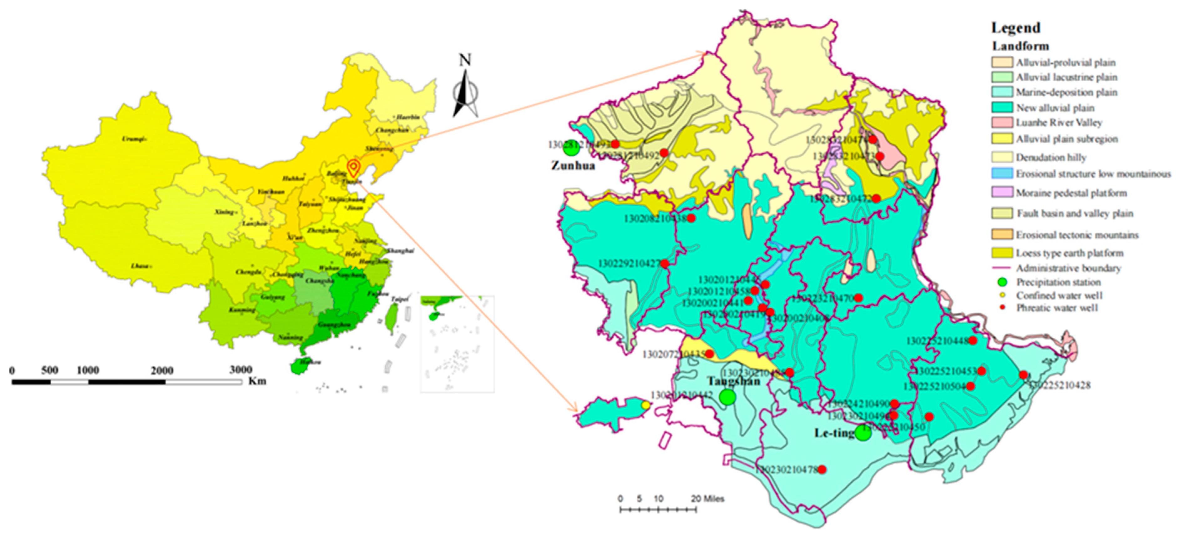
2. Study Area and Data
2.1. Location and Meteorology
2.2. Hydrogeology
2.3. Data Availability
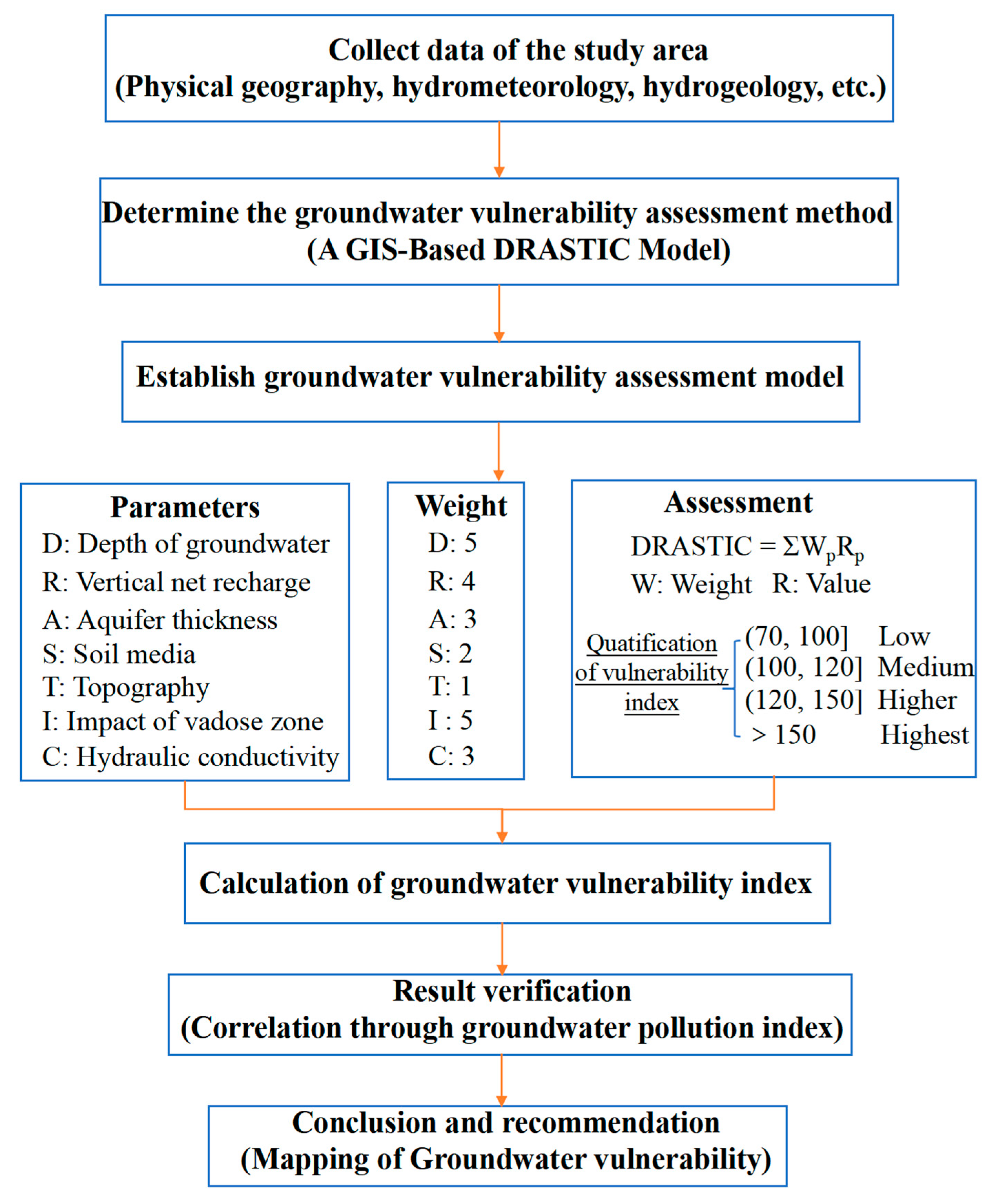
3. Methodology
3.1. Description of the GIS-Based DRASTIC Model Framework
3.2. Description of the GIS-Based DRASTIC Model Parameters
4. Results and Discussion
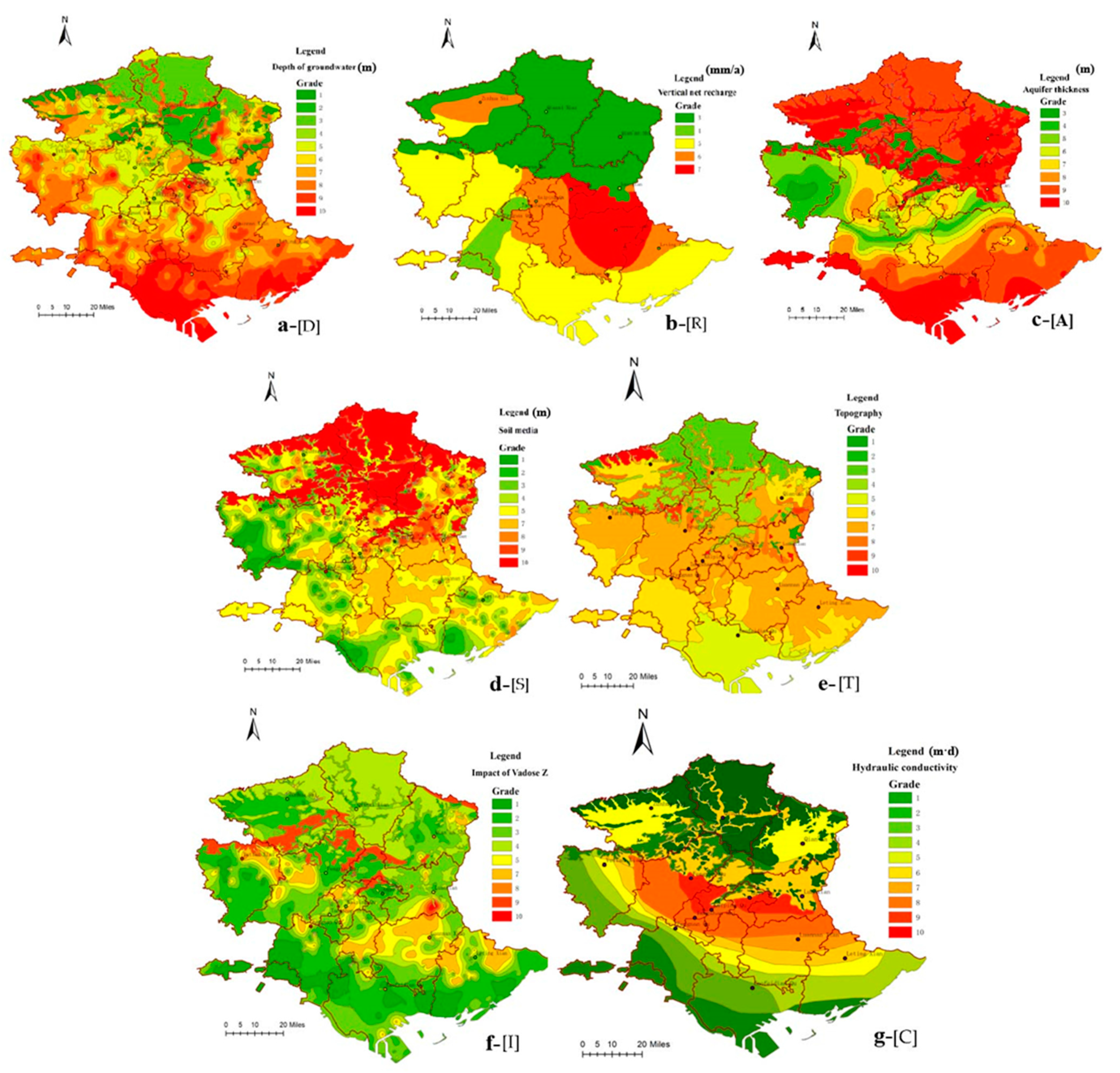
4.1. Results of Single Parameter Evaluation
4.1.1. Depth of Groundwater
4.1.2. Vertical Net Recharge
4.1.3. Aquifer Thickness
4.1.4. Soil Media
4.1.5. Topography
4.1.6. Impact of Vadose Zone
4.1.7. Hydraulic Conductivity
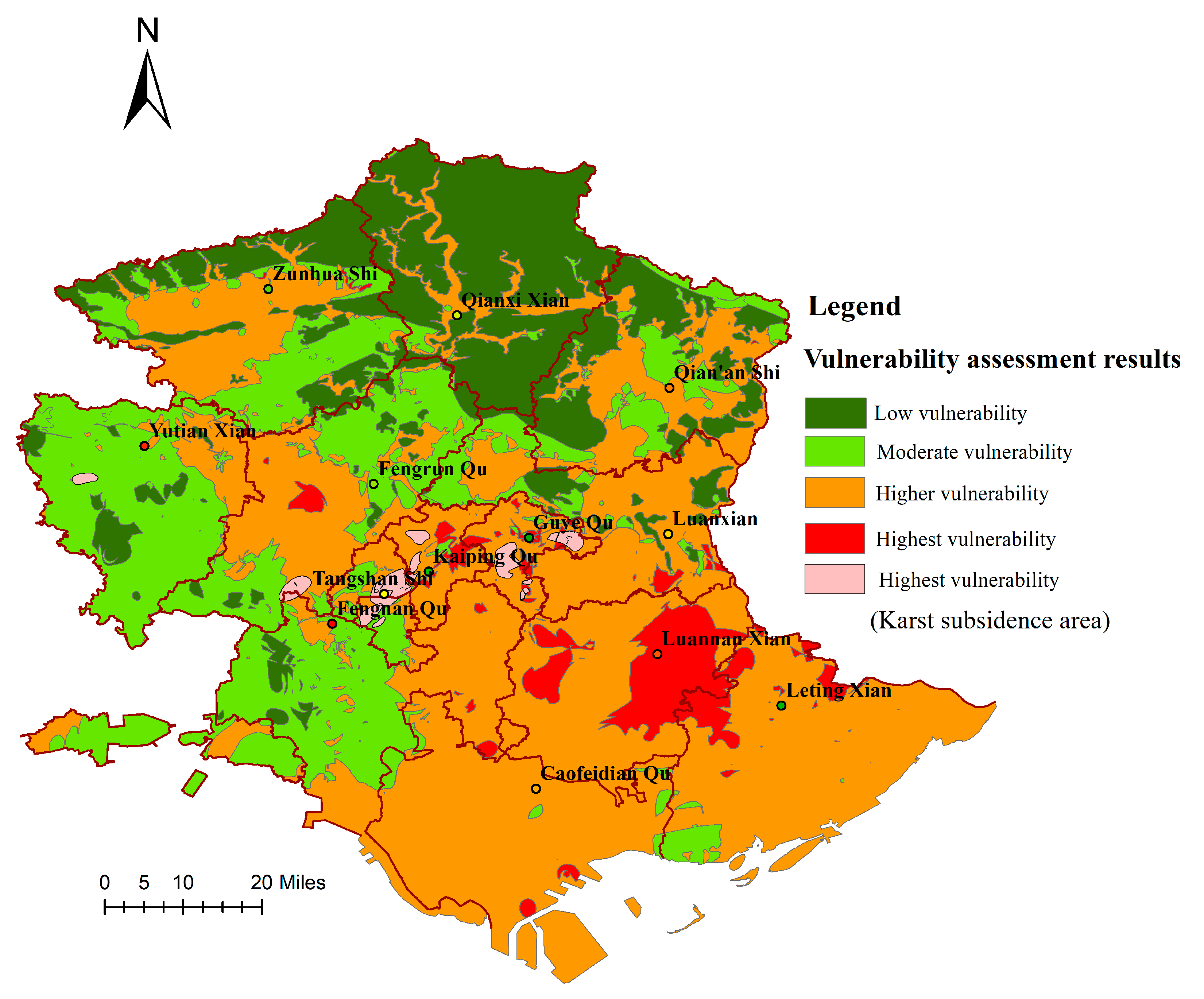
4.2. Results of Comprehensive Vulnerability Assessment and Its Validation
4.2.1. Results of Groundwater Vulnerability
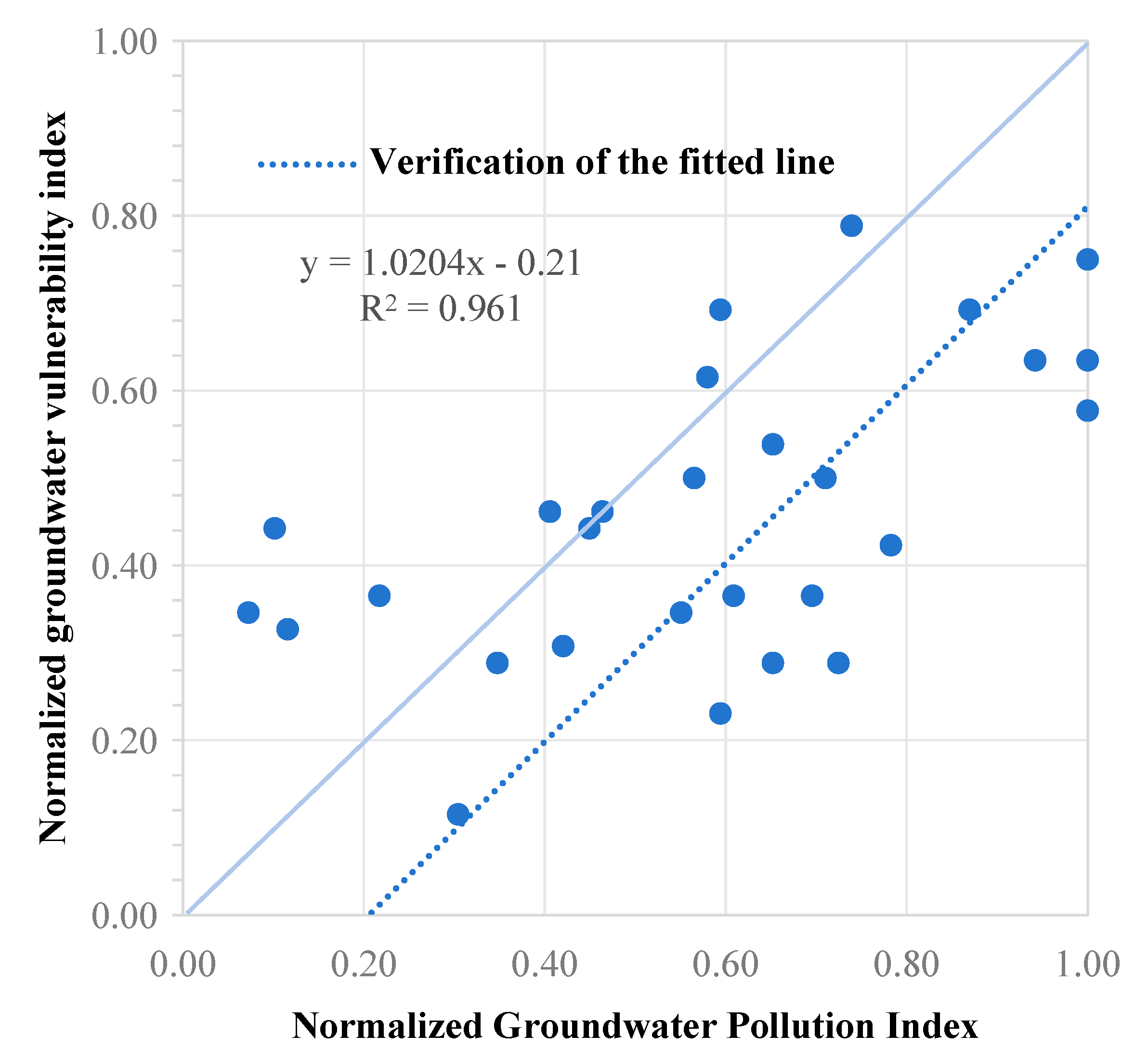
4.2.2. Validation for the Mapping of Groundwater Vulnerability
4.3. Groundwater Protection Strategy in Coastal Area
4.3.1. Groundwater Protection Objectives Based on Groundwater Vulnerability
- To guarantee water safety and prevent groundwater pollution. Groundwater is one of the important sources of drinking water, and protecting groundwater means guaranteeing people’s drinking water safety and basic usage of water.
- To maintain ecological balance on this basis. Protecting groundwater can maintain the water supply of wetlands, keep the stability of the ecological environment, and promote the maintenance of species diversity and the balance of the natural ecosystem.
- To pay attention to the protection of water sources for agricultural irrigation to ensure the sustainability of agricultural irrigation and maintain the normal growth of crops, paying particular attention to reducing the adverse effects on soil salinization in the coastal area.
- To prevent the decline in groundwater level and ground subsidence. Over-exploitation of groundwater will lead to the decline in groundwater level and ground subsidence, which will in turn lead to geological disasters and ground subsidence. One of the objectives of groundwater protection is to avoid these problems and maintain the stability of the groundwater system.
4.3.2. Groundwater Protect Measures in Study Area
- Reasonable land use and control of new highly polluting enterprises to reduce groundwater pollution: Urban planning, especially industrial zoning, should consider vulnerable areas and restrict the establishment of industrial zones in areas vulnerable to groundwater pollution, such as the center of Tangshan City, Kaiping District, Guye District, and Luannan County. In addition, wastewater discharge from industrial zones must be strictly managed to ensure that standards are met and groundwater pollution is controlled [51]. By controlling the sources of pollution, restricting the discharge of hazardous substances, and rationally managing groundwater extraction, it is possible to ensure that the quality of groundwater meets safety standards.
- Balanced control of groundwater exploitation: Over-exploitation of groundwater will lead to increased water hardness, groundwater pollution, and even ground subsidence. At this stage, deep wells with serious over-exploitation should be closed, the amount of groundwater extraction should be limited, and the number of new wells should be controlled.
- Regulate sewage irrigation and fertilizer use: It is important to control the amount of fertilizers used in agricultural areas and promote their effective use in order to minimize the amount that enters groundwater. Additionally, effluent used for irrigation should be analyzed and tested to ensure that it does not adversely affect soil and groundwater quality [52].
- The establishment of a comprehensive groundwater monitoring network and early warning system throughout the region is essential. Regular water quality monitoring should be carried out to detect early warning signs in time for timely interventions to mitigate serious consequences and to report data to ecological and environmental authorities.
4.3.3. Rigorous Implementation Plans for Groundwater Exploitation in High Vulnerability Area
- (1).
- Key groundwater pollution sources such as chemical and metal products industrial clusters, landfills, hazardous waste disposal sites, and other key groundwater pollution sources should be investigated and evaluated as soon as possible to map out the status of groundwater pollution, establish a system of seepage and leakage prevention for key groundwater pollution sources, carry out seepage and leakage prevention inspections every year, formulate seepage prevention and renovation plans for seepage prevention measures that do not satisfy the corresponding seepage prevention specification requirements, and take technical and management measures in a timely manner to eliminate hidden dangers.
- (2).
- For areas where groundwater pollution exists, detailed investigation and assessment of groundwater shall be further carried out, and where groundwater treatment and remediation or risk control is required after detailed investigation and assessment, control shall be strengthened and appropriate management shall be carried out in a timely manner. In areas where the health risk of groundwater pollution is unacceptable, the use of groundwater should be prohibited, and drainage methods such as pits and ponds should be restricted to reduce the disturbance of the polluted area; if drainage is really needed, it should be discharged in compliance with the standard after treatment.
- (3).
- Penalties should be established for enterprises and individuals who do not comply with the rules on groundwater protection, and they should be ordered to rectify the situation thoroughly before continuing production.
- (4).
- In areas where karst is strongly developed and where there are many fallout holes and karst funnels, construction projects that may cause groundwater pollution shall not be newly built, altered, or expanded.
5. Conclusions
Author Contributions
Funding
Institutional Review Board Statement
Informed Consent Statement
Data Availability Statement
Conflicts of Interest
References
- Singh, S.K.; Taylor, R.W.; Rahman, M.M.; Pradhan, B. Developing robust arsenic awareness prediction models using machine learning algorithms. J. Environ. Manag. 2018, 211, 125–137. [Google Scholar] [CrossRef]
- Houria, B.; Mahdi, K.; Zohra, T.F. Hydrochemical characterisation of groundwater quality: Merdja plain (Tebessa town, Algeria). Civ. Eng. J. 2020, 6, 318–325. [Google Scholar] [CrossRef]
- Döll, P.; Hoffmann-Dobrev, H.; Portmann, F.; Siebert, S.; Eicker, A.; Rodell, M.; Strassberg, G.; Scanlon, B. Impact of water withdrawals from groundwater and surface water on continental water storage variations. J. Geodyn. 2012, 59, 143–156. [Google Scholar] [CrossRef]
- Giordano, M. Global Groundwater? Issues and solutions. Annu. Rev. Environ. Resour. 2009, 34, 153–178. [Google Scholar] [CrossRef]
- Castellazzi, P.; Martel, R.; Galloway, D.L.; Longuevergne, L.; Rivera, A. Assessing groundwater depletion and dynamics using GRACE and InSAR: Potential and limitations. Groundwater 2016, 54, 768–780. [Google Scholar] [CrossRef] [PubMed]
- Çelik, R. Temporal changes in the groundwater level in the Upper Tigris Basin, Turkey, determined by a GIS technique. J. Afr. Earth Sci. 2015, 107, 134–143. [Google Scholar] [CrossRef]
- Narany, T.S.; Aris, A.Z.; Sefie, A.; Keesstra, S. Detecting and predicting the impact of land use changes on groundwater quality, a case study in Northern Kelantan, Malaysia. Sci. Total Environ. 2017, 599, 844–853. [Google Scholar] [CrossRef]
- Bui, L.K.; Le, P.V.V.; Dao, P.D.; Long, N.Q.; Pham, H.V.; Tran, H.H.; Xie, L. Recent land deformation detected by Sentinel-1A InSAR data (2016–2020) over Hanoi, Vietnam, and the relationship with groundwater level change. GISci. Remote Sens. 2021, 58, 161–179. [Google Scholar] [CrossRef]
- Chaussard, E.; Amelung, F.; Abidin, H.; Hong, S.-H. Sinking cities in Indonesia: ALOS PALSAR detects rapid subsidence due to groundwater and gas extraction. Remote Sens. Environ. 2013, 128, 150–161. [Google Scholar] [CrossRef]
- Khorrami, M.; Abrishami, S.; Maghsoudi, Y.; Alizadeh, B.; Perissin, D. Extreme subsidence in a populated city (Mashhad) detected by PSInSAR considering groundwater withdrawal and geotechnical properties. Sci. Rep. 2020, 10, 11357. [Google Scholar] [CrossRef]
- Orhan, O. Monitoring of land subsidence due to excessive groundwater extraction using small baseline subset technique in Konya, Turkey. Environ. Monit. Assess. 2021, 193, 174. [Google Scholar] [CrossRef] [PubMed]
- Tang, W.; Zhan, W.; Jin, B.; Motagh, M.; Xu, Y. Spatial Variability of Relative Sea-Level Rise in Tianjin, China: Insight from InSAR, GPS, and Tide-Gauge Observations. IEEE J. Sel. Top. Appl. Earth Obs. Remote Sens. 2021, 14, 2621–2633. [Google Scholar] [CrossRef]
- Putranto, T.T. Determining the groundwater vulnerability using the aquifer vulnerability index (AVI) in the Salatiga groundwater basin in Indonesia. AIP Conf. Proc. 2018, 2021, 030016. [Google Scholar] [CrossRef]
- Sarkar, M.; Pal, S.C. Application of DRASTIC and modified DRASTIC models for modeling groundwater vulnerability of Malda District in West Bengal. J. Indian Soc. Remote Sens. 2021, 49, 1201–1219. [Google Scholar] [CrossRef]
- Konikow, L.F.; Kendy, E. Groundwater depletion: A global problem. Hydrogeol. J. 2005, 13, 317–320. [Google Scholar] [CrossRef]
- Kumar, V.; Setia, R.; Pandita, S.; Singh, S.; Mitran, T. Assessment of U and As in groundwater of India: A meta-analysis. Chemosphere 2022, 303, 135199. [Google Scholar] [CrossRef]
- Chaves, J.; Neill, C.; Germer, S.; Neto, S.G.; Krusche, A.; Elsenbeer, H. Land management impacts on runoff sources in small Amazon watersheds. Hydrol. Process. 2008, 22, 1766–1775. [Google Scholar] [CrossRef]
- Van Dijck, S.J.; Laouina, A.; Carvalho, A.V.; Loos, S.; Schipper, A.M.; Van der Kwast, H.; Nafaa, R.; Antari, M.; Rocha, A.; Borrego, C. Desertification in northern Morocco due to effects of climate change on groundwater recharge. In Desertification in the Mediterranean Region. A Security Issue; Springer: Berlin/Heidelberg, Germany, 2006; pp. 549–577. [Google Scholar] [CrossRef]
- Cui, Y.; Liao, Z.; Wei, Y.; Xu, X.; Song, Y.; Liu, H. The Response of Groundwater Level to Climate Change and Human Activities in Baotou City, China. Water 2020, 12, 1078. [Google Scholar] [CrossRef]
- Mohammed, O.A.; Sayl, K.N. A GIS-based multicriteria decision for groundwater potential zone in the west desert of Iraq. In IOP Conference Series: Earth and Environmental Science; IOP Publishing: Bristol, UK, 2021; Volume 856, p. 012049. [Google Scholar] [CrossRef]
- Mohammed, O.A.; Sayl, K.N. Determination of groundwater potential zone in arid and semi-arid regions: A review. In Proceedings of the 2020 13th International Conference on Developments in eSystems Engineering (DeSE), Virtual, 14–17 December 2020; IEEE: Piscataway, NJ, USA, 2020; pp. 76–81. [Google Scholar] [CrossRef]
- Falade, A.O.; Oni, T.E.; Oyeneyin, A. Comparative effect of lateritic shield in groundwater vulnerability assessment using GLSI and LC models: A case study of Ijero mining site, Ijero-Ekiti. Model. Earth Syst. Environ. 2023, 9, 3253–3262. [Google Scholar] [CrossRef]
- Pavlis, M.; Cummins, E. Assessing the vulnerability of groundwater to pollution in Ireland based on the COST-620 Pan-European approach. J. Environ. Manag. 2014, 133, 162–173. [Google Scholar] [CrossRef]
- Prasad, R.K.; Singh, V.S.; Krishnamacharyulu, S.K.G.; Banerjee, P. Application of drastic model and GIS: For assessing vulnerability in hard rock granitic aquifer. Environ. Monit. Assess. 2011, 176, 143–155. [Google Scholar] [CrossRef] [PubMed]
- Vaezihir, A.; Tabarmayeh, M. Total vulnerability estimation for the Tabriz aquifer (Iran) by combining a new model with DRASTIC. Environ. Earth Sci. 2015, 74, 2949–2965. [Google Scholar] [CrossRef]
- Wen, X.; Wu, J.; Si, J. A GIS-based DRASTIC model for assessing shallow groundwater vulnerability in the Zhangye Basin, northwestern China. Environ. Geol. 2009, 57, 1435–1442. [Google Scholar] [CrossRef]
- Aller, L.; Thornhill, J. DRASTIC: A Standardized System for Evaluating Ground Water Pollution Potential Using Hydrogeologic Settings; Robert, S., Ed.; Kerr Environmental Research Laboratory, Office of Research and Development, US Environmental Protection Agency: Washington, DC, USA, 1987. [Google Scholar]
- Panagopoulos, G.P.; Antonakos, A.K.; Lambrakis, N.J. Optimization of the DRASTIC method for groundwater vulnerability assessment via the use of simple statistical methods and GIS. Hydrogeol. J. 2006, 14, 894–911. [Google Scholar] [CrossRef]
- Kwon, E.; Park, J.; Park, W.-B.; Kang, B.-R.; Hyeon, B.-S.; Woo, N.C. Nitrate vulnerability of groundwater in Jeju Volcanic Island, Korea. Sci. Total Environ. 2022, 807, 151399. [Google Scholar] [CrossRef]
- Rama, F.; Busico, G.; Arumi, J.L.; Kazakis, N.; Colombani, N.; Marfella, L.; Hirata, R.; Kruse, E.E.; Sweeney, P.; Mastrocicco, M. Assessment of intrinsic aquifer vulnerability at continental scale through a critical application of the drastic framework: The case of South America. Sci. Total Environ. 2022, 823, 153748. [Google Scholar] [CrossRef]
- An, Y.; Lu, W. Assessment of groundwater quality and groundwater vulnerability in the northern Ordos Cretaceous Basin, China. Arab. J. Geosci. 2018, 11, 118. [Google Scholar] [CrossRef]
- Bai, L.; Wang, Y.; Meng, F. Application of DRASTIC and extension theory in the groundwater vulnerability evaluation. Water Environ. J. 2012, 26, 381–391. [Google Scholar] [CrossRef]
- Chen, S.M.; Liu, F.T.; Zhang, Z.; Zhang, Q.; Wang, W. Changes of groundwater flow field of Luanhe River Delta under the human activities and its impact on the ecological environment in the past 30 years. China Geol. 2021, 4, 455–462. [Google Scholar] [CrossRef]
- Hydrogeological Manual, China Geological Survey. 2023. Available online: https://kns.cnki.net/KCMS/detail/detail.aspx?dbname=SNAD&filename=SNAD000001542056 (accessed on 28 August 2023).
- US EPA (Environmental Protection Agency). DRASTIC: A Standard System for Evaluating Groundwater Potential Using Hydrogeological Settings; Oklahoma WA/EPA Series, Ada; US EPA (Environmental Protection Agency): Washington, DC, USA, 1985; p. 163.
- China Geological Survey. Delineation of Priority Areas for Groundwater Pollution Prevention and Control Technical Guideline; China Geological Survey: Beijing, China, 2022.
- Yu, H.; Wu, Q.; Zeng, Y.; Zheng, L.; Xu, L.; Liu, S.; Wang, D. Integrated variable weight model and improved DRASTIC model for groundwater vulnerability assessment in a shallow porous aquifer. J. Hydrol. 2022, 608, 127538. [Google Scholar] [CrossRef]
- Abu-Bakr, H.A.E.-A. Groundwater vulnerability assessment in different types of aquifers. Agric. Water Manag. 2020, 240, 106275. [Google Scholar] [CrossRef]
- Hayashi, M.; Farrow, C.R. Watershed-scale response of groundwater recharge to inter-annual and inter-decadal variability in precipitation (Alberta, Canada). Hydrogeol. J. 2014, 22, 1825–1839. [Google Scholar] [CrossRef]
- Nair, A.M.; Prasad, K.R.; Srinivas, R. Groundwater vulnerability assessment of an urban coastal phreatic aquifer in India using GIS-based DRASTIC model. Groundw. Sustain. Dev. 2022, 19, 100810. [Google Scholar] [CrossRef]
- Taghavi, N.; Niven, R.K.; Kramer, M.; Paull, D.J. Comparison of DRASTIC and DRASTICL groundwater vulnerability assessments of the Burdekin Basin, Queensland, Australia. Sci. Total Environ. 2023, 858, 159945. [Google Scholar] [CrossRef]
- Rodriguez-Galiano, V.; Mendes, M.P.; Garcia-Soldado, M.J.; Chica-Olmo, M.; Ribeiro, L. Predictive modeling of groundwater nitrate pollution using Random Forest and multisource variables related to intrinsic and specific vulnerability: A case study in an agricultural setting (Southern Spain). Sci. Total Environ. 2014, 476, 189–206. [Google Scholar] [CrossRef]
- Goyal, D.; Haritash, A.; Singh, S. A comprehensive review of groundwater vulnerability assessment using index-based, modelling, and coupling methods. J. Environ. Manag. 2021, 296, 113161. [Google Scholar] [CrossRef]
- Khosravi, K.; Sartaj, M.; Tsai, F.T.-C.; Singh, V.P.; Kazakis, N.; Melesse, A.M.; Prakash, I.; Bui, D.T.; Pham, B.T. A comparison study of DRASTIC methods with various objective methods for groundwater vulnerability assessment. Sci. Total Environ. 2018, 642, 1032–1049. [Google Scholar] [CrossRef]
- Jiang, W.; Sheng, Y.; Wang, G.; Shi, Z.; Liu, F.; Zhang, J.; Chen, D. Cl, Br, B, Li, and noble gases isotopes to study the origin and evolution of deep groundwater in sedimentary basins: A review. Environ. Chem. Lett. 2022, 20, 1497–1528. [Google Scholar] [CrossRef]
- Jin, G.; Shimizu, Y.; Onodera, S.; Saito, M.; Matsumori, K. Evaluation of drought impact on groundwater recharge rate using SWAT and Hydrus models on an agricultural island in western Japan. Proc. Int. Assoc. Hydrol. Sci. 2015, 371, 143–148. [Google Scholar] [CrossRef]
- Zhuang, Y.; Tao, W.; Jun, L. Evaluation of special vulnerability of groundwater in Guangzhou based on fuzzy comprehensive judgment. Mod. Geol. 2011, 25, 796–801. (In Chinese) [Google Scholar]
- Hua, J.; Ke, W.; Ying, Q. Special vulnerability of groundwater in the Guanzhong Basin and its evaluation. J. Jilin Univ. 2009, 39, 1106–1116. (In Chinese) [Google Scholar]
- Yuan, X.; Yang, Y.; Lu, L. Modeling and validation of groundwater pollution prevention performance zoning in reclaimed water irrigation areas. J. Agric. Eng. 2010, 26, 57–63. (In Chinese) [Google Scholar]
- GB14848-2017; China Environmental Quality Standards for Groundwater. PRC State Administration of Quality Supervision and Quarantine: Beijing, China, 2017.
- Balacco, G.; Alfio, M.R.; Fidelibus, M.D. Groundwater Drought Analysis under Data Scarcity: The Case of the Salento Aquifer (Italy). Sustainability 2022, 14, 707. [Google Scholar] [CrossRef]
- Kruseman, G.P.; De Ridder, N.A.; Verweij, J.M. Analysis and Evaluation of Pumping Test Data; International Institute for land Reclamation and Improvement: Wageningen, The Netherlands, 1983; Volume 11, p. 200. Available online: https://www.researchgate.net/publication/284969758 (accessed on 28 August 2023).


| Parameter | Description | Relative Weight |
|---|---|---|
| Depth of groundwater (D) | Depth to groundwater table is the distance from the surface to the submerged surface; unit is m. | 5 |
| Vertical net recharge (R) | Approximate using precipitation infiltration recharge instead of vertical net recharge; unit is mm/a. | 4 |
| Aquifer thickness (A) | Aquifer thickness can be analyzed from borehole data; refers to the saturated zone material properties, which controls the pollutant attenuation processes; unit is m. | 3 |
| Soil media (S) | The soil media is a weathered layer with a thickness of 2 m or less at the surface, which controls the amount of recharge that can infiltrate downward. | 2 |
| Topography (T) | Slope values can be automatically generated in GIS after DEM extraction from 1:50,000 or 1:10,000 topographic maps. | 1 |
| Impact of Vadose Zone (I) | The unsaturated zone material: it controls the passage and attenuation of the contaminated material to the saturated zone. | 5 |
| Hydraulic conductivity (C) | Indicates the ability of the aquifer to transmit water, and hence determines the rate of flow of contaminant material within the groundwater system. | 3 |
| Parameter | Grade | |||||||||
|---|---|---|---|---|---|---|---|---|---|---|
| 1 | 2 | 3 | 4 | 5 | 6 | 7 | 8 | 9 | 10 | |
| D (m) | >30 | (25, 30] | (20, 25] | (15, 20] | (10, 15] | (8, 10] | (6, 8] | (4, 6] | (2, 4] | ≤2 |
| R (mm/a) | 0 | (0, 51] | (51, 71] | (71, 92] | (92, 117] | (117, 147] | (147, 178] | (178, 216] | (216, 235] | >235 |
| A (m) | >50 | (45, 50] | (40, 45] | (35, 40] | (30, 35] | (25, 30] | (20, 25] | (15, 20] | (10, 15] | ≤10 |
| S | rock | clay loam | silt loam | loam | sandy loam | swelling or condensing clay | silt-sand/fine sand | medium sand/coarse sand | gravel-cobble | thin layer or missing |
| T(%) | >10 | (9, 10] | (8, 9] | (7, 8] | (6, 7] | (5, 6] | (4, 5] | (3, 4] | (2, 3] | ≤2 |
| I | clay | loam | sandy loam soil | silt-sand | silty, fine sand | fine sand | medium sand | coarse sand | sand gravel | gravel-cobble |
| C (m/d) | [0, ≤4] | (4, 12] | (12, 20] | (20, 30] | (30, 35] | (35, 40] | (40, 60] | (60, 80] | (80, 100] | >100 |
| Groundwater Vulnerability Composite Index Value | Vulnerability | Level |
|---|---|---|
| (70, 100] | Potentially contaminated | Low |
| (100, 120] | Easily contaminated | Moderate |
| (120, 150] | highly prone to be contaminated | Higher |
| >150 | Particularly vulnerable to be contaminated | Highest |
| Assigned Index | pH | TH mg/L | TDS mg/L | F− mg/L | Cl− mg/L | SO42− mg/L | NO3− mg/L | NO2− mg/L | Fe mg/L | Cu mg/L | Mn mg/L |
|---|---|---|---|---|---|---|---|---|---|---|---|
| 1 | 6.5–8 | 150 | 300 | 0.2 | 50 | 50 | 2 | 0.005 | 0.1 | 0.01 | 0.01 |
| 3 | 6–6.5; 8–8.5 | 300 | 500 | 0.5 | 150 | 150 | 5 | 0.01 | 0.2 | 0.05 | 0.05 |
| 5 | 5.5–6.0; 8.5–9 | 450 | 1000 | 1 | 250 | 250 | 20 | 1 | 0.3 | 1 | 0.1 |
| 7 | 1–5.5; 9–13 | 650 | 2000 | 2 | 350 | 350 | 30 | 4.8 | 2 | 1.5 | 1.5 |
| 10 | 0–1; 13–14 | >650 | >2000 | >2 | >350 | >350 | >30 | >4.8 | >2 | >1.5 | >1.5 |
Disclaimer/Publisher’s Note: The statements, opinions and data contained in all publications are solely those of the individual author(s) and contributor(s) and not of MDPI and/or the editor(s). MDPI and/or the editor(s) disclaim responsibility for any injury to people or property resulting from any ideas, methods, instructions or products referred to in the content. |
© 2023 by the authors. Licensee MDPI, Basel, Switzerland. This article is an open access article distributed under the terms and conditions of the Creative Commons Attribution (CC BY) license (https://creativecommons.org/licenses/by/4.0/).
Share and Cite
Zhang, Q.; Shan, Q.; Chen, F.; Liu, J.; Yuan, Y. Groundwater Vulnerability Assessment and Protection Strategy in the Coastal Area of China: A GIS-Based DRASTIC Model Approach. Appl. Sci. 2023, 13, 10781. https://doi.org/10.3390/app131910781
Zhang Q, Shan Q, Chen F, Liu J, Yuan Y. Groundwater Vulnerability Assessment and Protection Strategy in the Coastal Area of China: A GIS-Based DRASTIC Model Approach. Applied Sciences. 2023; 13(19):10781. https://doi.org/10.3390/app131910781
Chicago/Turabian StyleZhang, Qian, Qiang Shan, Feiwu Chen, Junqiu Liu, and Yingwei Yuan. 2023. "Groundwater Vulnerability Assessment and Protection Strategy in the Coastal Area of China: A GIS-Based DRASTIC Model Approach" Applied Sciences 13, no. 19: 10781. https://doi.org/10.3390/app131910781
APA StyleZhang, Q., Shan, Q., Chen, F., Liu, J., & Yuan, Y. (2023). Groundwater Vulnerability Assessment and Protection Strategy in the Coastal Area of China: A GIS-Based DRASTIC Model Approach. Applied Sciences, 13(19), 10781. https://doi.org/10.3390/app131910781