Abstract
Quantifying the impacts of climate change on evapotranspiration (ET) and gross primary production (GPP) in the Dongting Lake Basin is essential for assessing water scarcity and implementing sustainable development strategies. Premised on actual measurements and remote sensing data from 47 stations, the impact of climate change on eco-hydrological parameters in the Dongting Lake Basin was analyzed in the present study using the BESS model (The Breathing Earth System Simulator), ridge regression analysis, stepwise regression model and time-lag analysis. The results reveal that: (1) the Dongting Lake Basin has been warm and arid over the last four decades, with the frequent occurrence of extreme climate events. Vegetation carbon sequestration capacity exhibited a slightly upward trend with 0.0081 g C m−2 d−1/year from 2000–2017. ET changed with rates of −3.309 mm/year, with possible risk conflicts between water demand and supply in the future. (2) The increasing temperature was the main driver of ET enhancement in the Dongting Lake Basin. Meanwhile, both temperature and precipitation were found to be the dominant drivers of GPP enhancement. The effect of temperature on GPP was found to be greater in the areas covered by crops and tree vegetation, and natural vegetation was more strongly influenced by precipitation than radiation. (3) Extreme temperature events have had a significant impact on evapotranspiration (ET) and gross primary production (GPP) in the Dongting Lake Basin. Specifically, the cold index in extreme temperature events was found to significantly affect ET, while the heat index in extreme temperature events significantly affected GPP. Additionally, both ET and GPP were found to respond to extreme precipitation events in the region. The results of the study established that vegetation is highly sensitive to temperature, especially temperature extremes, and that precipitation also has a stressful effect. Increasing temperatures and precipitation within a range benefit vegetation productivity. (4) In the Dongting Lake Basin, we found that different climatic factors produced different time lag effects on GPP and ET by time lag analysis. This study highlights the lag effects of climate factors and extreme climate events on eco-hydrological parameters. We suggest incorporating the effects into simulation models of eco-hydrological parameters. This will lead to a better understanding of the variation of eco-hydrological parameters under climate change.
1. Introduction
As is widely accepted, the global climate is experiencing a significant change in terms of warming patterns [1,2]. Global warming has emerged as a key environmental concern around the world. According to the Sixth Assessment Report of the International Intergovernmental Panel on Climate Change (IPCC), global greenhouse gas emissions increased by an average of 1.3% per year between 2010 and 2019. If such trend continues, the average annual temperature increase will reach 3.2 °C by the end of the 21st century, thereby resulting in considerable social and climate-related risks [3]. The warming of the planet is predicted to accelerate the water cycle, leading to an increase in extreme weather events such as droughts and floods [4]. In the field of meteorology and natural disasters, studies on the temporal trends and spatial distribution of extreme climate events, and related research on the various influencing factors of extreme climate events have become a trending topic for governments and scholars [5]. In recent years, the significant changes observed in the global climate have prompted widespread concern. The climate of the Dongting Lake Basin has also been impacted by such changes. As a result, there is a growing concern regarding climate change within the region.
Climate change, land use and cover change, and human disturbance can lead to a range of ecological effects that affect ecological health [6,7]. Further, climate change has a significant impact on the quality of ecosystems [8]. Evapotranspiration (ET) is a core component that links energy balance and water balance, and represents water consumption [9]. Gross primary productivity (GPP) of vegetation represents total carbon emissions, which is the source of food and wood production [10]. The long-term trend of GPP can effectively detect the environmental changes in the watershed ecosystem and reflect the quality of the ecosystem environment. GPP can be used as an important indicator of the regional ecosystem carbon sinks or sources. ET is the main pathway for energy and water transfer and conversion in the three systems of terrestrial plants and atmospheres, and one of the important components of the hydrosphere, atmospheric, and bioregional water cycle. ET has an important role in the energy needs and material transformations of the earth’s atmosphere and hydrosphere biosphere. GPP and ET provide an important component of terrestrial eco-hydrological processes, and they are closely coupled through leaf stomatal-regulated transpiration and photosynthesis. GPP and ET can be taken as significant parameters of regional eco-hydrology to reflect regional eco-hydrological changes. GPP and ET are significant components of the hydrological processes in terrestrial ecosystems and have a strong impact on the ecological environment. They are regulated by leaf stomata and coupled through transpiration and photosynthesis. In essence, ET and GPP have similar response characteristics under climate change scenarios [11]. Research on the control mechanisms of ET and GPP can offer a scientific foundation for evaluating vegetation productivity and water consumption, as well as attributing them to specific causes. The Dongting Lake Basin serves important ecological functions, such as flood control, climate regulation, water purification, and maintenance of biodiversity. Since Dongting Lake has a powerful water storage function, the tremendous water storage capacity of this ecosystem has a great role in regulating river runoff, intercepting surface runoff, and controlling floods. The large amount of evapotranspiration in the Dongting Lake Basin could increase the humidity of the air and it could be manifested in lowering the air temperature, hence attenuating the strong atmospheric changes. The unique water dynamics and environmental conditions of Dongting Lake have reproduced extremely rich biodiversity and harbor extremely valuable species genes. As wetland whose main objective is to protect the habitat of rare migratory birds of global significance, it has been included in the list of important international wetlands. Therefore, ecological protection of the Dongting Lake Basin will have a significant impact on the Yangtze River basin and is an considerable part of maintaining ecological and economic stability in the middle and lower reaches of the Yangtze River Basin. Studies have shown that the ecological and environmental quality of the Dongting Lake Basin has fluctuated considerably over the last two decades. Such fluctuations may be closely linked to the climate change, complex land use types and anthropogenic disturbances in the Dongting Lake Basin. As such, studying the ecological and environmental factors in the Dongting Lake Basin holds significant importance [10].
In the present study, the overall trends of climate and extreme climate events in the Dongting Lake Basin over the past four decades were evaluated. The BESS model was applied to simulate the ET and GPP at 47 sites in the Dongting Lake basin, and the impacts of climate factors on ET and GPP within the Dongting Lake Basin were analyzed while eliminating the effects of various climate factors. The mechanisms of various climate factors and extreme climate events on GPP and ET were investigated utilizing monthly-scale data. Such research deepens the understanding of the ecological response mechanisms to climate change and is vital for the future ecological protection of the Dongting Lake Basin. In this work, two carbon and water cycle indicators, GPP and ET, were selected as eco-hydrological process parameters. The average and extreme climatic conditions of the basin were comprehensively considered. Based on multi-source remote sensing data and the vegetation productivity model, we qualitatively and quantitatively assessed the impacts of temperature and precipitation events on vegetation productivity and ET in the Dongting Lake Basin. The BESS model is an ecological process model, which has a relatively complex structure, a large number of difficult-to-obtain input parameters, and a high sensitivity of simulation results to the input parameters. The BESS model applies remotely sensed data to couple atmospheric and canopy radiative transfer processes, two-leaf photosynthesis, energy balance, and evapotranspiration. The BESS model applies remote sensing data to couple atmospheric and canopy radiative transfer processes, two-leaf photosynthesis, energy balance, and evapotranspiration. The sensitivity of BESS to leaf area index and solar irradiance, the most important variables controlling GPP and ET, was intentionally increased in the model. The study area of this paper is the Dongting Lake Basin, which belongs to the region with extensive vegetation cover. The BESS model was chosen to simulate the eco-hydrological parameters in the Dongting Lake basin. Combined with the time lag analysis of temperature and precipitation events on eco-hydrological parameters, the time lag effect of different climatic factors on eco-hydrological parameters at monthly scales can be quantitatively assessed. It is recommended that the effects of climatic factors on them be taken into account in future model simulations. The specific objectives of the present study were: (1) to analyze the spatial and temporal patterns of long-term temperature, precipitation, extreme climate events, GPP, and ET in the Dongting Lake Basin; (2) to assess the contributions of temperature, precipitation, and radiation to the changes in ET and GPP; and (3) to analyze the effects of extreme climate events on GPP and ET in the Dongting Lake Basin. The results facilitate further understanding of the complex effects of meteorological drivers on the water-carbon cycle in the Dongting Lake Basin and are beneficial for eco-hydrological environmental assessment and water resource management.
2. Materials and Methods
2.1. Study Area
The Dongting Lake Basin (24.4°~30.9° N, 107.3°~114.7° E) is the second largest sub-basin in the middle and lower reaches of the Yangtze River [12,13] (Figure 1). As one of the 200 priority ecological areas for conservation worldwide [14], over 80% of the Dongting Lake Basin area is within China’s Hunan Province and accounts for small portions of Hubei, Chongqing, Guizhou, Jiangxi provinces and the Guangxi Zhuang Autonomous Region. The Dongting Lake Basin has a subtropical monsoon climate characterized by four distinct seasons, where rainfall and warmth occur simultaneously. The Dongting Lake Basin is a significant part of the hydrological system in the middle and lower reaches of the Yangtze River. The basin downstream of Dongting Lake has an integral role in mitigating floods and maintaining the balance of water and sand. The Dongting Lake Basin is integral in serving as a commercial food production base, and providing internationally significant wintering habitat for waterfowl [15,16]. Dongting Lake Basin consists of the Xiangjing River Basin, Zishui River Basin, Yuanjing River Basin, Lishui River Basin, and Dongting Lake region (Figure 1).
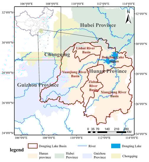
Figure 1.
Location of the Dongting Lake Basin in China.
2.2. Data Preparation
In the present study, 47 meteorological data sites within the Dongting Lake Basin were selected (Figure 2). The percentage of different land cover types in the Dongting Lake Basin and its sub-basins is shown in Figure 3. Data were obtained from The National Meteorological Scientific Data Sharing Service Platform (http://data.cma.cn, accessed on 10 March 2022). The data used included daily-scale temperature, precipitation, site barometric pressure, relative humidity, wind direction and speed, and short-wave radiation at the sites. Temperature and precipitation data can be used to calculate extreme climate events using RClimDex (https://github.com/ECCC-CDAS/RClimDex, accessed on 16 July 2023).
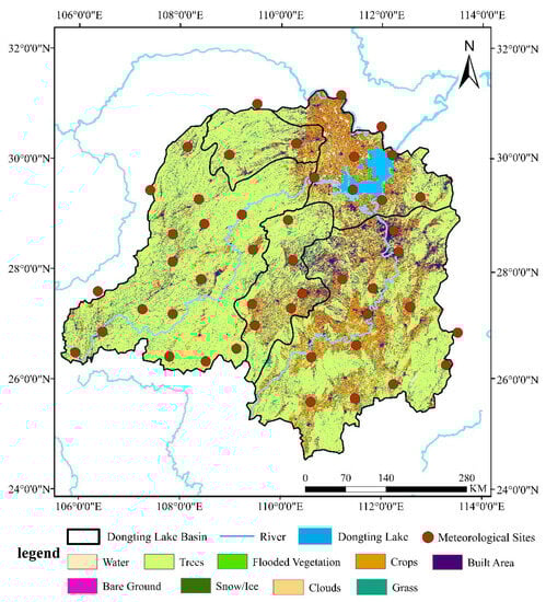
Figure 2.
Landcover and location of 47 meteorological sites in the Dongting Lake Basin.
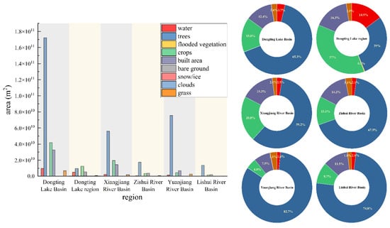
Figure 3.
Percentage of different land cover types in the Dongting Lake Basin and sub-basins.
The BESS model was driven by infrared radiation data, air temperature, pressure, wind speed, albedo, land cover type, leaf area index, CI, fC4, canopy height, ambient CO2 concentration, and leaf carbonyl. To operate, the BESS model needed land cover type, and leaf area index data from MODIS remote sensing products (https://ladsweb.nascom.nasa.gov/search, accessed on 11 March 2022). Albedo data were obtained from GLASS (http://geodata.cn, accessed on 11 March 2022). CI, fC4, canopy height, ambient CO2 concentration, and leaf carbonyl were driven by data from Chongya Jiang’s study [17]. The specific input data is presented in Table 1.

Table 1.
Introduction to BESS model input data.
The BESS model uses an atmospheric light environment simulator that allows the simulation of direct and diffuse radiation in the photosynthetically active radiate on (PAR) and near-infrared (NIR) spectral domains. The foliar canopy radiative transfer model simulates PAR and NIR absorbed by sunlit and shaded canopies. The plant function type (PFT) further increases leaf V25C to light or shade canopy levels based on maximum leaf carboxylation capacity (V25C) at 25 °C with leaf trait data. Saturated vapor pressure, specific heat of air, and clear sky emissivity can be derived using temperature, humidity, and pressure data. The carbon-water coupling module includes a two-leaf longwave radiative transfer model and a plant photosynthesis model for C3 and C4. The stomatal conductance equation, Penman-Monteith equation, and energy balance equation simulate the GPP and ET of the light and shade canopies as well as the evapotranspiration of the soil in an iterative calculation. This process simulates five variables: sunlit leaf temperature, shade leaf temperature, soil temperature, intercellular CO2 concentration, and aerodynamic coefficients. Finally, the simulated instantaneous estimates of GPP and ET were temporarily upscaled to daily average estimates using the cosine function. The BESS model could be used to simulate regional GPP and ET, which has shown satisfactory simulation outcomes.
The GPP data used for model validation were obtained from Global Land Surface Satellite (GLASS) and can be found at http://www.geodata.cn/index.html, accessed on 23 March 2022. GLASS products are long-series, high-precision global surface remote sensing products obtained by inversion based on multi-source remote sensing data and ground-truthing data. These products provide a reliable foundation for the studies of global environmental change and they could be widely applied to global, intercontinental, and regional monitoring of the dynamics of the atmosphere, vegetation cover, and water bodies. This, combined with climate change characterization parameters, such as temperature and precipitation, is to be applied to the analysis of global change. The ET data used for model validation were obtained from http://files.ntsg.umt.edu/data/ET_global_monthly/, accessed on 25 March 2022.
2.3. Methodology
The trends of climate factors, ET and GPP, were calculated using simple linear regression. The Manner-Kendall mutation test and the cumulative distance level method were adopted to investigate the years of abrupt change in temperature and precipitation.
Temperature, precipitation, and solar radiation were selected as the main meteorological factors. Since ridge regression is considered an effective method for eliminating the problem of covariance between independent variables [18]. the method was adopted in the present study to eliminate the covariance among climate factors and separate the contributions of changes among different climate factors. The method in Xie Shudi’s study was used to calculate the contributions of temperature, precipitation, and radiation to GPP and ET in the Dongting Lake Basin [11].
Stepwise regression models were applied to analyze the effects of various extreme climate indices on GPP and ET. The time lag was analyzed using correlation analysis.
3. Results and Discussion
3.1. Model Validation
BESS is a concise process-based model that provides greater insight into the underlying interaction mechanisms compared with machine learning and semi-empirical models, as well as a better understanding of the synergistic responses to environmental changes [19,20,21]. GPP and ET data simulated by BESS have been shown to be consistent with the observed fluxes at sites (33 sites, 33 site-years) for different land cover types and climate zones [22]. As such, the ET and GPP simulated by applying the BESS model have high reliability.
The results simulated by the BESS model were fitted with the GLASS product data in the present study, so as to verify the accuracy of the simulation results of the BESS model in Dongting Lake Basin (Figure 4). The results show that the correlation coefficient between the simulation results of the BESS model and the GLASS product of GPP data was 0.934 with an RMSE value of 1.9998. The results simulated by the BESS model were fitted with the ET data of PLSH products, and the results show that the correlation coefficient between the simulation results of the BESS model and PLSH products of ET was 0.8650 with an RMSE value of 6.3919. The results indicate that the GPP and ET data in the Dongting Lake Basin simulated by the BESS model are credible. The deviation of the validation data from the simulation data could be attributed to the limited number of meteorological stations [11].
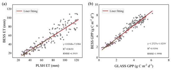
Figure 4.
(a) The fit of the BESS model in Dongting Lake basin to GLASS products, respectively; (b) the fit of the BESS model and PLSH model ET results in Dongting Lake basin.
3.2. Spatial-Temporal Changes in Climate Variables, GPP and ET
3.2.1. Changes in Climate Variables
Interdecadal variations of temperature and precipitation from 1980 to 2020 in Dongting Lake Basin are shown in Figure 5. The test results for sudden changes in temperature and precipitation are shown in Figure 6. The results show that the overall temperature in the Dongting Lake Basin exhibited an upward trend at 0.0339 °C/year from 1980 to 2020 with an R2 of 0.5034 (p < 0.05). According to the cumulative distance plot, 1997 was the time point when the sudden change in temperature occurred, which could be ascribed to the considerably large floods that occurred in the Dongting Lake Basin in 1998. Further, the temperature exhibited a more rapid response to the environmental conditions during this period. Such results are consistent with the Manner-Kendall test for abrupt changes in temperature.
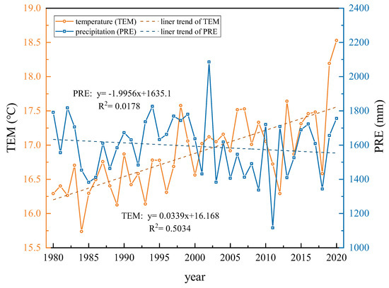
Figure 5.
Average temperature and precipitation trends in the Dongting Lake Basin from 1980 to 2020.
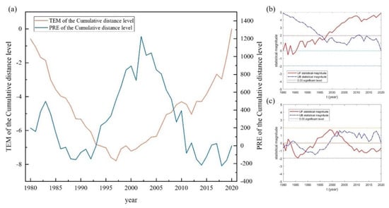
Figure 6.
Analysis of sudden changes in average temperature and precipitation in the Dongting Lake Basin from 1980 to 2020. (a) Temperature and precipitation of the cumulative distance level; (b) temperature of the Manner-Kendall mutation test; (c) precipitation of the Manner-Kendall mutation test.
In the Dongting Lake Basin, precipitation is highly fluctuating and is in an insignificant fluctuating downward trend. The precipitation was relatively stable from 1980 to 2001, before varying more drastically in the following years. Precipitation in the Dongting Lake Basin has changed abruptly five times in the last four decades, namely in 1981, 1982, 1983, 1990, and 2003, and no abrupt temperature changes occurred in the remaining years. An observation can be made that the precipitation in the Dongting Lake Basin was not considerably stable in the 1980s, with several abrupt changes occurring. According to the cumulative distance of precipitation, from 1980 to 1986, the precipitation in the basin underwent a process of significant increase to slow increase. From 1987 to 1993, the precipitation exhibited a decreasing trend. From 1994 to 2003, the precipitation in the basin increased significantly. Between 2004 and 2011, the rate of precipitation increase in the basin decelerated. Subsequently, from 2012 to 2020, the basin experienced a decrease in precipitation, which remained at a low level during this period.
Variation trends of temperature and precipitation in different seasons were similar to that of mean annual temperature and precipitation, of which the characteristics are shown in Figure 7.
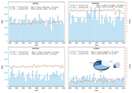
Figure 7.
Temperature and precipitation trends by different seasons and the percentage of precipitation in different seasons in the Dongting Lake Basin from 1980 to 2020.
The temperature and precipitation in Dongting Lake Basin fluctuated during four seasons, and the trend was not obvious. However, it can be seen that the temperature in the Dongting Lake Basin fluctuates and increases in the spring (March–May). In contrast, precipitation in the study area showed a fluctuating downward trend, with a larger precipitation decrease, which was especially obvious in the four seasons. The summer (June–August) showed a fluctuating downward trend in temperature, which was the only season in the Dongting Lake Basin that showed a downward trend in temperature. Precipitation changes in the study area showed a decreasing trend. In the fall (September–January), the temperature in the Dongting Lake Basin showed a fluctuating upward trend. On the contrary, precipitation changes showed a fluctuating downward trend. The temperature in winter (December–February of the following year) showed a fluctuating upward trend. Figure 6 shows a fluctuating downward trend in precipitation, with the smallest decrease in precipitation during the four seasons.
Overall, the temperature and precipitation in the Dongting Lake Basin have fluctuated considerably over the past few decades, but it could be seen that the precipitation generally decreases in all seasons and the temperature is increasing with fluctuations. This indicates an insignificant trend of climate warming and drought in the Dongting Lake Basin since the mid-1980s.
3.2.2. Changes in Extreme Climate Event Variables
Eleven extreme climate indices were selected for the study (Table 2). The temporal and spatial trends of 47 stations of extreme climate events in the Dongting Lake Basin were analyzed (Figure 8).
Table 2.
List of the selected 11 ETCCDI core climate indices and their definitions.
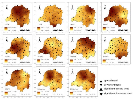
Figure 8.
Spatial variation characteristics of extreme climate indices in the Dongting Lake Basin.
TXx, Txn, TNx, and TNn represent the indices of the extreme values of temperature in the extreme temperature index. As shown in Figure 7, the spatial trends of the variables were similar, with the majority of sites exhibiting an upward trend. Both TXx and TNx displayed a spatial pattern of being higher in the northern region and lower in the southern region. Conversely, TXn and TNn exhibited a spatial pattern of being higher in the southern region and lower in the northern region.
TX10P and TN10P are indices representing the frequency of cold extremes in the temperature extreme index. An observation can be made that the majority of sites exhibited a downward trend in TX10P and TN10P, indicating a decrease in the frequency of cold extremes at these sites. TX90P and TN90P are indices representing the frequency of hot extremes in the temperature extreme index represent the heat index in the extreme temperature index, with the majority of sites exhibiting an upward trend. TX10P, TN10P, and TN90P exhibited a spatial pattern of being higher in the southern region and lower in the northern region. Conversely, TX90P exhibited a spatial pattern of being higher in the northern region and lower in the southern region. DTR exhibited different patterns across various sites in the Dongting Lake Basin, suggesting that the temperature varied across the study area.
RX1day and RX5day can indicate heavy rainfall events in extreme precipitation events. The sites in the Lishui River Basin indicated a decreasing trend, while an increasing trend was exhibited at other sites. Such findings indicate that extreme precipitation events have occurred frequently over the last four decades, except for in the Lishui River Basin.
3.2.3. Changes in GPP and ET
The annual GPP and ET from the Dongting Lake Basin are shown in Figure 9. The average GPP in the Dongting Lake Basin from 2000 to 2017 exhibited high fluctuations. The mean value of GPP in the Dongting Lake Basin from 2000 to 2017 was 6.375 g C m−2 d−1, with the maximum value occurring in 2000, being 6.779 g C m−2 d−1. The minimum value appeared in 2005, being 5.842 g C m−2 d−1. Research has shown that GPP is generally increasing in most regions of the world as a result of climate change [23,24,25]. An observation can be made that the GPP in the study area had the same trend.
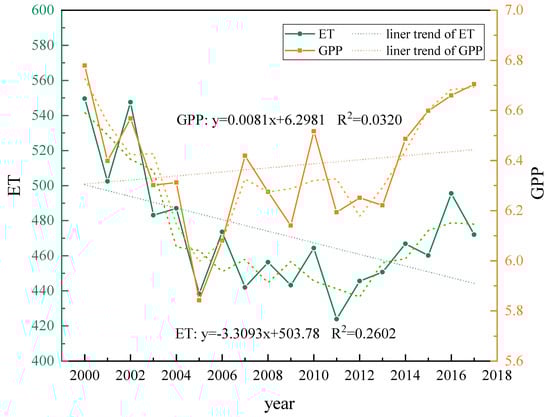
Figure 9.
Interannual trends in GPP and ET in the Dongting Lake Basin from 2000 to 2017.
The average ET in the Dongting Lake Basin from 2000 to 2017 showed a fluctuating decreasing trend with a significant decreasing rate of −3.309 mm/year. The mean ET was 472.339 mm, with the maximum value occurring in 2000, being 549.568 mm. Meanwhile, the minimum value occurred in 2011, being 423.903 mm.
According to Figure 9, GPP and ET had similar trends. Essentially, ET and GPP have similar response characteristics under climate change scenarios [11]. ET and GPP are interrelated and significant environmental factors.
Figure 10 shows the seasonal variations of GPP and ET in the Dongting Lake Basin.
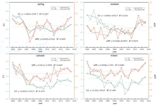
Figure 10.
Trends of GPP and ET in different seasons in the Dongting Lake Basin from 2000 to 2017.
During the spring season (March-May), GPP exhibited an upward trend with a rate of increase of 0.0052 g C m−2 d−1/year. At the same time, ET had a downward trend in the study area with a rate of decrease of −1.2961 mm/year.
For GPP in the summer season (June–August), an upward trend was identified with a rate of 0.0168 g C m−2 d−1/year. ET exhibited a significant downward trend in the study area with a rate of decrease of −1.6004 mm/year, being the most prominent among the four seasons.
In the autumn season (September–January), GPP in the Dongting Lake Basin exhibited an upward trend with a rate of increase of 0.0011 g C m−2 d−1/year. On the other hand, ET displayed a downward trend with a rate of decrease of −0.6933 mm/year.
In the winter season (December–February of the following year), GPP in the Dongting Lake Basin exhibited an upward trend with a rate of increase of 0.0028 g C m−2 d−1/year. Meanwhile, ET showed a fluctuating downward trend with a rate of decrease of −0.332 mm/year, being the least evident among the four seasons as shown in Figure 9.
The spatial distribution characteristics of GPP and ET in the Dongting Lake Basin are shown in Figure 11. The GPP of the Dongting Lake Basin between 2000 and 2017 ranged from 0.88 g C m−2 d−1 to 7.17 g C m−2 d−1. Meanwhile, the ET ranged from 336.60 mm to 546.48 mm. The spatial distribution characteristics of GPP and ET in the Dongting Lake Basin were found to be similar, with both demonstrating a pattern of high values in the west and low values in the north. GPP and ET in the Dongting Lake Basin showed higher levels in the Yuan River Basin and the Li River Basin, which have high tree, grass, and crop coverage.
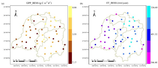
Figure 11.
Spatial distribution of GPP (a) and ET (b) in the Dongting Lake basin from 2000 to 2017.
3.3. Contributions of Long-Term Changes to GPP and ET
3.3.1. Relative Contributions of Climate Change to GPP and ET
The contributions of temperature, precipitation, and radiation to GPP are shown in Figure 12 and Table 3. In the Dongting Lake Basin, the main climatic factor controlling the trend of GPP was found to be temperature (the average relative contribution was 44.73 ± 14.54%), with precipitation (the average contribution was 44.04 ± 17.58%) playing a slightly smaller role than temperature, with radiation (the average contribution was 11.22 ± 8.13%) being the smallest.
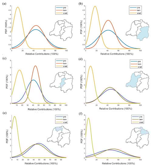
Figure 12.
Probability density function plots of temperature, precipitation, and radiation on GPP in Dongting Lake Basin and its different regions. (a) Dongting Lake Basin; (b) Xiangjiang River Basin; (c) Zishui River Basin; (d) Yuanjiang River Basin; (e) Lishui River Basin; (f) Dongting Lake region.
Table 3.
Relative contributions of factors to GPP and ET in the Dongting Lake Basin and its sub-basin.
In the Xiangjiang River Basin, where crops, trees, and buildings are the main vegetation types, the fluctuation of GPP was found to be primarily influenced by temperature, with the average contribution reaching 41.38 ± 11.54%. Precipitation had a slightly smaller role, with an average contribution of 41.32 ± 17.70%. Radiation had a relatively small effect on GPP, with an average contribution of 17.29 ± 7.73%. Crop, tree, and grass are the main vegetation types in the Zishui River Basin. Temperature was found to play a major role in the changes in GPP, with an average contribution of 44.28 ± 6.94%. The role of precipitation was slightly smaller than temperature, with an average contribution of 40.54 ± 11.16%. The role of radiation (average contribution of 15.18 ± 7.83%) was the smallest. The vegetation cover type in the Yuanjiang River Basin is mainly trees, and the greatest influence factor on the trend of GPP change was found to be precipitation (average contribution of 46.41 ± 16.80%). The role of temperature (average contribution of 44.57 ± 14.85%) was slightly smaller compared to precipitation. The role of radiation (average contribution of 9.03 ± 6.37%) was the smallest for GPP change (Figure 12d). The role of temperature in the Lishui River Basin on GPP was slightly smaller than that of precipitation, with an average contribution of 45.47 ± 14.71%. The role of radiation was the smallest among the climate factors in the present study, with an average contribution of 5.08 ± 4.5%. The role of radiation was the least important climate factor in the study, with an average contribution of 5.08 ± 4.84%. The Dongting Lake region is mainly covered by crops, water, and grasslands. The temperature was found to play a dominant role in the change of GPP, with an average contribution of 50.59 ± 19.68%. The role of precipitation was slightly less than that of temperature, with an average contribution of 44.04 ± 22.29%, and radiation was the least important climate factor, with an average contribution of 5.37 ± 4.46%.
An observation can be made that temperature and precipitation played a dominant role in the changes in GPP in the Dongting Lake Basin, and the contributions of precipitation and radiation to GPP were considerably small. Temperature also played a larger role in each sub-region of the basin, while radiation was the climate factor that played the smallest role in terms of GPP. Among the sub-regions, the temperature played a slightly larger role than precipitation in the Xiangjiang River Basin and Zishui River Basin, while precipitation played a slightly larger role than the temperature in the Yuanjiang River Basin, Lishui River Basin, and Dongting Lake regions. There are more crops and trees in the Xiangjiang Basin and Zishui River Basin than in other sub-regions, indicating that the role of air temperature on GPP is greater in the areas covered by crops and trees in the Dongting Lake Basin.
Climate change has an impact on vegetation productivity by affecting the physiological processes and phenology of plants. To be specific, climate warming has a positive effect on the growth of vegetation by prolonging the growing season, leading to an increase in greening [26,27]. Changes in vegetation productivity in the Dongting Lake Basin were found to be generally influenced by meteorological factors, especially temperature. Spatial characteristics of vegetation productivity, on the other hand, were mainly influenced by land use, followed by precipitation and elevation. For terrestrial ecosystems, processes such as climate change, fertilization effects of CO2, nitrogen deposition, land use types, and land cover changes are the major influences on vegetation carbon sequestration, in other words, vegetation productivity [28,29]. Additionally, the interaction between different factors was significant [30]. In the present study, both temperature and precipitation generally contributed more to GPP in the Dongting Lake Basin, while the contribution of radiation was relatively small.
The contributions of temperature, precipitation, and radiation to ET are shown in Figure 13 and Table 3. In the entire Dongting Lake Basin, the main climatic factor controlling the trend of ET was the temperature (average relative contribution of 64.60 ± 12.89%). Radiation (average contribution of 17.63 ± 10.73%) and precipitation (average contribution of 17.77 ± 11.76%) had similar contributions, with radiation being slightly smaller. In the Dongting Lake Basin, temperature is the main driver of water evaporation. The climate in the Dongting Lake Basin has fluctuated over the past four decades, but overall temperatures are higher than before. The higher temperature was conducive to the growth of ET. This suggests that the evapotranspiration of water in the Dongting Lake Basin, driven by air temperature, will be more than before. Meanwhile, the precipitation in Dongting Lake Basin has decreased in fluctuation in the last four decades, therefore, Dongting Lake Basin might have a conflict between water demand and water supply in the subsurface in the future.
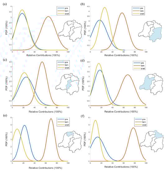
Figure 13.
Probability density function plots of temperature, precipitation, and radiation on ET in Dongting Lake Basin and its different regions. (a) Dongting Lake Basin; (b) Xiangjiang River Basin; (c) Zishui River Basin; (d) Yuanjiang River Basin; (e) Lishui River Basin; (f) Dongting Lake region.
The Xiangjiang River Basin is dominated by crops, trees, and buildings as the main land use types. Among the climate factors, temperature was found to play a dominant role in the variation of ET, with an average contribution of 57.14 ± 10.00%. The influence of precipitation on ET was relatively small, with an average contribution of 16.95 ± 12.40%. With crops, trees, and grasses as the main vegetation types in the Zishui River Basin, temperature was found to play a major role in the variation of ET, with an average contribution of 53.53 ± 8.10%. The relative contributions of precipitation (average contribution of 24.88 ± 12.38%) and radiation (average contribution of 21.60 ± 10.73%) were similar, with precipitation being slightly larger than radiation. In the Yuanjiang River Basin, the predominant form of vegetation cover is trees. The most significant climatic factor influencing the trend of ET change was found to be temperature, contributing an average of 67.34 ± 12.18%. In contrast, radiation had a relatively minor effect on ET change, with an average contribution of 15.38 ± 8.92%. The Lishui River Basin is largely dominated by trees as the main vegetation cover type, and some areas in the eastern part are covered by crops. In the region, changes in ET were primarily influenced by the temperature factor, which had an average contribution of 69.41 ± 5.58%. Meanwhile, radiation had the smallest impact among the studied climatic factors, with an average contribution of 8.66 ± 7.37%. The Dongting Lake region is mainly covered by crops, water, and grasslands. Temperature was found to play a dominant role in the variation of ET, with an average contribution of 77.40 ± 8.14%. Radiation was the climate factor with the least important role, with an average contribution of 9.33 ± 6.65%.
An observation can be made that temperature played a dominant role in the variation of ET in the Dongting Lake Basin. It was also found to be the most important climate factor in all sub-regions of the basin, except for the Xiangjiang River Basin, where radiation had the least contribution. Since the Xiangjiang River Basin has more building coverage compared to other regions, it was inferred that natural vegetation was significantly affected by precipitation rather than radiation.
ET can reflect changes in hydrology. The results of the present study show that temperature variation has a significant effect on hydrological parameters. Such results are consistent with those in research on other regions. Over the last 50 years, there has been a significant upward trend in global high temperatures, which has accelerated global water cycle processes [31]. Precipitation dominates the ET variability in most of China [32], which is evident in arid and semi-arid regions [33]. In the present study, temperature was the main influencing factor for ET, which could be attributed to the abundance of rivers and surface water in the Dongting Lake Basin. As such, precipitation did not act as the most dominant influence on ET.
3.3.2. Extreme Climate Indices with Significant Impacts on GPP and ET
TNn, TNx, TXn, TXx, DTR, TX10P, TX90P, TN10P, TN90P, RX1day, and RX5day were used as independent variables, while GPP was used as the dependent variable for stepwise regression analysis. Following the automatic identification of the model, TNx, DTR, TX90P, TN90P, RX1day, and RX5day were the only variables that remained in the final model, as shown in Figure 14. The R2 value was 0.906, indicating that TNx, DTR, TX90P, TN90P, RX1day, and RX5day could explain 90.6% of the variation in GPP. The model passed the F-test (F = 334.096, p = 0.000 < 0.05), indicating that the model was valid. The model equation was: GPP = −0.606 + 0.221 × TNx + 0.174 × DTR − 0.027 × TX90P − 0.032 × TN90P + 0.043 × RX1day − 0.012 × RX5day.
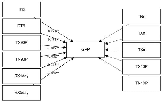
Figure 14.
Stepwise regression model of extreme climate indices and GPP in Dongting Lake Basin. (** indicates significant correlation).
Research has shown that the net primary productivity of vegetation in the Dongting Lake Basin is strongly influenced by climate extremes, and there are differences in the effects of different extreme climate factors on the net primary productivity of vegetation [34]. The present study shows that the heat index in the extreme temperature index had a relatively large effect on GPP in the Dongting Lake Basin, which could be ascribed to the heat sensitivity of vegetation.
ET, as the dependent variable, was subjected to stepwise regression analysis (Figure 15). After the automatic identification of the model, a total of three terms, TNn, TN10P, and RX5day, were finally left in the model. The R2 value was 0.902, implying that TNn, TN10P, and RX5day could explain 90.2% of the causes of change in ET. The model passed the F-test (F = 650.233, p = 0.000 < 0.05), indicating that the model was valid. The model equation was: ET = 14.756 + 2.462 × TNn + 0.329 × TN10P + 0.171 × RX5day.
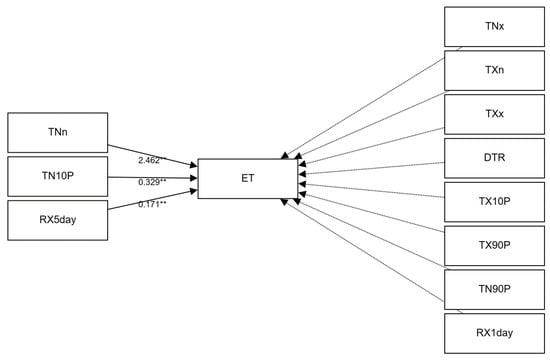
Figure 15.
Stepwise regression model of extreme climate indices and ET in Dongting Lake Basin. (** indicates significant correlation).
During the dormant and early growing seasons, extreme cold weather prevents evaporation. However, during the peak growing season, excessive precipitation provides sufficient moisture for surface evaporation [35]. In the present study, the results show that the extreme precipitation index representing heavy rainfall had a positive effect on ET, which could be ascribed to moisture provided by extreme precipitation events. However, in the study of this article, it was shown that the increase in precipitation was unfavorable to the growth of ET. It indicated that in Dongting Lake Basin, sudden extreme rainfall events and increased precipitation in the average climate state have not same effect on ET. Sudden heavy rainfall events make regional moisture increase which is favorable for ET growth. However, prolonged rainfall made the regional air moisture higher, which was detrimental to the growth of ET.
3.3.3. Analysis of the Time Lag in Climatic Factors on Major Eco-Hydrological Parameters
It is widely recognized that climate change affects vegetation growth and dynamics [36], and that vegetation responses to climate are often complex and have temporal effects [37]. In particular, the time-lag effect refers to the significant influence of vegetation growth by the climatic conditions of the previous month [38]. Different climate factors showed different lag effects on the same vegetation type [38]. There is a time-lag effect in the response of key eco-hydrological parameters to climate change in the Dongting Lake Basin. Therefore, the study of the time-lag response of GPP and ET to climate factors can deeply reflect the mechanism of climate change and key eco-hydrological parameters. Based on the monthly scale data, a study on the time lag effects of GPP, ET and climate factors in the Dongting Lake Basin was accomplished.
The whole correlation of GPP to the radiation of the same month shows a high level of correlation. Negative correlations were exhibited in the summer. The Dongting Lake Basin showed no lag effect of GPP with temperature and radiation, and a 2-month lag effect with precipitation. GPP responded more rapidly to temperature and radiation than to precipitation. Findings show that the global average optimum temperature for vegetation photosynthesis is 23 ± 6 °C [39]. The vegetation cover in the Dongting Lake Basin is mostly trees and crops, and the general temperature of the basin is suitable for vegetation growth. Therefore, photosynthesis of vegetation would be more sensitive to the change in this temperature. Vegetation is generally supplemented by precipitation in the previous monthly or bimonthly period, so there is a certain lag effect of precipitation. ET in the Dongting Lake Basin showed no lag effect with temperature, precipitation, or radiation.
The whole correlation of GPP to the radiation of the same month shows a high level of correlation. Negative correlations were exhibited in the summer. The Dongting Lake Basin showed no lag effect of GPP with temperature and radiation, and a 2-month lag effect with precipitation. GPP responded more rapidly to temperature and radiation than to precipitation (Figure 16a). The vegetation cover in the Dongting Lake Basin is mostly trees and crops, and the general temperature of the basin is suitable for vegetation growth. Therefore, photosynthesis of vegetation would be more sensitive to the change in this temperature. Vegetation is generally supplemented by precipitation in the previous monthly or bimonthly period, so there is a certain lag effect of precipitation. ET in the Dongting Lake Basin showed no lag effect with temperature, precipitation, or radiation (Figure 16b).
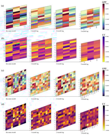
Figure 16.
Time-lag analysis of GPP and ET by climate factors and extreme climate indices. (a) Climate factors and GPP; (b) climate factors and ET; (c) extreme climate indices and GPP; (d) extreme climate indices and ET.
The time-lag analysis on GPP and extreme climate events is shown in Figure 16c. In the Dongting Lake Basin GPP responded to the extreme precipitation events in the same month. The extreme precipitation indices used at this time were all related to the extreme precipitation strength, which was extreme precipitation events related to the maximum amount of precipitation. It indicates that there is no time lag in the occurrence of heavy rainfall events that affect GPP. When the GPP of the basin was relatively high, the occurred of extreme temperature events negatively affected the GPP in the summer and fall. The Dongting Lake Basin has a high level of crop and tree vegetation cover. With the average temperature of the basin at 17.798 °C to 26.132 °C in summer and fall, the temperature is suitable for the growth of plants and beneficial for photosynthesis. Extreme weather events would break the suitable state of plant growth and have a negative impact on GPP with no time lag effect.
The time-lag analysis of ET and extreme climate events is shown in Figure 16d. The highest correlation between ET and extreme precipitation index in the Dongting Lake Basin was found for the first 3 months. Extreme precipitation events had a 3-month lag effect on ET. Extreme precipitation events were not beneficial to the growth of ET from May to September, while the remaining months had a positive effect. From May to September belongs to the period of high precipitation, when the Dongting Lake Basin has sufficient precipitation. In this background, any further heavy precipitation events would be too much and have a negative impact on ET. The highest correlation between ET and the extreme weather index in the Dongting Lake Basin was found for the same month. The occurrence of extreme weather events had no lag effect on ET. The extreme weather heat index was mostly positively correlated in spring and winter, while the cold index was negatively correlated. This indicates that the occurrence of extreme heat events at relatively low average state temperatures in the Dongting Lake Basin is beneficial to ET growth.
4. Conclusions
Over the entire Dongting Lake Basin, climate change is highly volatile. While the climate was, on the whole, warmer and drier in the latter part of the study period. Meanwhile, the seasonal variation of climate was similar to that of interannual. The BESS eco-hydrological dynamic model predicted that annual ET and GPP changed slightly with a rate of −1.6004 mm/year and 0.0168 g C m−2 d−1/year, respectively. The trend was higher than that of precipitation in the Dongting Lake Basin, which may lead to potential conflicts between water supply and demand. The results of the ridge regression analysis indicate that an increase in temperature was the primary driving factor for the intensification of ET in the Dongting Lake Basin. At the same time, both temperature and precipitation were found to be the dominant driving factors for enhancing GPP in the study area. The results reveal a high sensitivity of vegetation carbon cycle and water to temperature. Against the backdrop of frequently occurring extreme climate events, the cold index in extreme temperature events had a significant effect on ET while the heat index in extreme temperature events had a significant effect on GPP. Further, both GPP and ET were found to be responsive to extreme precipitation events in the Dongting Lake Basin. The effects of extreme climate events on GPP and ET should not be neglected. The results of the present study confirm that vegetation is highly sensitive to temperature, especially extreme temperatures, and precipitation also has a stressful effect. As such, the extreme climate change needs to be assessed to protect the eco-hydrological environment.
Using the time lag analysis, we found that the correlation between temperature and radiation on GPP, ET in the same month is highest, and the correlation between precipitation and ET showed the same result, and there is no significant time lag effect between each of them. The interesting part is that there is a 2-month lag effect in the effect of precipitation on GPP. This is due to the fact that the vegetation cover in the Dongting Lake Basin is mostly trees and crops, and the vegetation is generally recharged by precipitation in one or two of the previous months. There is no time lag effect between GPP and ET on extreme weather events, and GPP on extreme precipitation events showed the same result. There is a 3-month lag in the ET response to extreme precipitation events. We found that in the Dongting Lake Basin, the occurrence of extreme heat events was favorable to ET growth when the average state temperature was relatively low. These results indicate that some climate factors and extreme climate indices have a lag effect on GPP and ET. We propose to incorporate these effects into simulation models of eco-hydrological parameters. This will provide a better understanding of the effects on eco-hydrological parameters under climate change.
Author Contributions
F.Z.: Conceptualization, Writing—Original Draft, Investigation, Software. Y.G.: Writing—Review & Editing, Supervision, Funding acquisition. L.Y.: Investigation. J.W.: Investigation. All authors have read and agreed to the published version of the manuscript.
Funding
This work was financially supported by the National Natural Science Foundation of China (41975044, 41925007, and 41801021).
Institutional Review Board Statement
Not applicable.
Informed Consent Statement
Informed consent was obtained from all subjects involved in the study.
Data Availability Statement
Meteorological data were obtained from The National Meteorological Scientific Data Sharing Service Platform (http://data.cma.cn, accessed on 10 March 2022). The BESS model needed some data from MODIS remote sensing products (https://ladsweb.nascom.nasa.gov/search, accessed on 11 March 2022).
Conflicts of Interest
The authors declare no conflict of interest.
References
- Chu, J.T.; Xia, J.; Xu, C.-Y.; Singh, V.P. Statistical downscaling of daily mean temperature, pan evaporation and precipitation for climate change scenarios in Haihe River, China. Theor. Appl. Clim. 2009, 99, 149–161. [Google Scholar] [CrossRef]
- Huang, J.; Zhang, J.; Zhang, Z.; Xu, C.; Wang, B.; Yao, J. Estimation of future precipitation change in the Yangtze River basin by using statistical downscaling method. Stoch. Environ. Res. Risk Assess. 2010, 25, 781–792. [Google Scholar] [CrossRef]
- Zhongming, Z.; Linong, L.; Xiaona, Y.; Wei, L. AR6 Synthesis Report: Climate Change 2022; IPCC: Geneva, Switzerland, 2022. [Google Scholar]
- Douglas, I.; Alam, K.; Maghenda, M.; Mcdonnell, Y.; Mclean, L.; Campbell, J. Unjust waters: Climate change, flooding and the urban poor in Africa. Environ. Urban. 2008, 20, 187–205. [Google Scholar] [CrossRef]
- Sun, W.; Mu, X.; Song, X.; Wu, D.; Cheng, A.; Qiu, B. Changes in extreme temperature and precipitation events in the Loess Plateau (China) during 1960–2013 under global warming. Atmos. Res. 2016, 168, 33–48. [Google Scholar] [CrossRef]
- Jia, H.; Pan, D.; Zhang, W. Health Assessment of Wetland Ecosystems in the Heilongjiang River Basin, China. Wetlands 2015, 35, 1185–1200. [Google Scholar] [CrossRef]
- Jiang, W.; Pan, Y.Z.; Hou, P.; Li, X.; Ji, W.; Zheng, J.R. Assessment and analysis of wetland ecosystem health in Dongting Lake. Geogr. Res. 2009, 28, 1665–1672. [Google Scholar]
- Prakash, S. Impact of climate change on aquatic ecosystem and its biodiversity: An overview. Int. J. Biol. Innov. 2021, 3, 312–317. [Google Scholar] [CrossRef]
- Chen, X.; Mo, X.; Hu, S.; Liu, S. Contributions of climate change and human activities to ET and GPP trends over North China Plain from 2000 to 2014. J. Geogr. Sci. 2017, 27, 661–680. [Google Scholar] [CrossRef]
- Yuan, B.; Fu, L.; Zou, Y.; Zhang, S.; Chen, X.; Li, F.; Deng, Z.; Xie, Y. Spatiotemporal change detection of ecological quality and the associated affecting factors in Dongting Lake Basin, based on RSEI. J. Clean. Prod. 2021, 302, 126995. [Google Scholar] [CrossRef]
- Xie, S.; Mo, X.; Hu, S.; Liu, S. Contributions of climate change, elevated atmospheric CO2 and human activities to ET and GPP trends in the Three-North Region of China. Agric. For. Meteorol. 2020, 295, 108183. [Google Scholar] [CrossRef]
- Huang, F.; Qian, B.; Ochoa, C.G. Long-term river water temperature reconstruction and investigation: A case study of the Dongting Lake Basin, China. J. Hydrol. 2023, 616, 128857. [Google Scholar] [CrossRef]
- Zhang, X.; Liu, M. Assessing the Spatial and Temporal Patterns of Seasonal Precipitation Extremes and the Potential Influencing Factors in Dongting Lake Basin, China. Water 2016, 8, 558. [Google Scholar] [CrossRef]
- Olson, D.M.; Dinerstein, E. The Global 200: A representation approach to conserving the Earth’s most biologically valuable ecoregions. Conserv. Biol. 1998, 12, 502–515. [Google Scholar] [CrossRef]
- Cao, L.; Barter, M.; Lei, G. New Anatidae population estimates for eastern China: Implications for current flyway estimates. Biol. Conserv. 2008, 141, 2301–2309. [Google Scholar] [CrossRef]
- Zou, Y.-A.; Zhang, P.-Y.; Zhang, S.-Q.; Chen, X.-S.; Li, F.; Deng, Z.-M.; Yang, S.; Zhang, H.; Li, F.-Y.; Xie, Y.-H. Crucial sites and environmental variables for wintering migratory waterbird population distributions in the natural wetlands in East Dongting Lake, China. Sci. Total. Environ. 2019, 655, 147–157. [Google Scholar] [CrossRef]
- Jiang, C.; Ryu, Y. Multi-scale evaluation of global gross primary productivity and evapotranspiration products derived from Breathing Earth System Simulator (BESS). Remote Sens. Environ. 2016, 186, 528–547. [Google Scholar] [CrossRef]
- Walker, E.; Birch, J.B. Influence measures in ridge regression. Technometrics 1988, 30, 221–227. [Google Scholar] [CrossRef]
- Niu, G.Y.; Yang, Z.-L.; Mitchell, K.E.; Chen, F.; Ek, M.B.; Barlage, M.; Kumar, A.; Manning, K.; Niyogi, D.; Rosero, E.; et al. The community Noah land surface model with multiparameterization options (Noah—MP): 1. Model description and evaluation with local-scale measurements. J. Geophys. Res. Atmos. 2011, 116, D12109. [Google Scholar] [CrossRef]
- Shao, C.; Chen, J.; Li, L. Grazing alters the biophysical regulation of carbon fluxes in a desert steppe. Environ. Res. Lett. 2013, 8, 025012. [Google Scholar] [CrossRef]
- Shao, P.; Zeng, X.; Sakaguchi, K.; Monson, R.K.; Zeng, X. Terrestrial Carbon Cycle: Climate Relations in Eight CMIP5 Earth System Models. J. Clim. 2013, 26, 8744–8764. [Google Scholar] [CrossRef]
- Ryu, Y.; Baldocchi, D.D.; Kobayashi, H.; Van Ingen, C.; Li, J.; Black, T.A.; Beringer, J.; Van Gorsel, E.; Knohl, A.; Law, B.E.; et al. Integration of MODIS land and atmosphere products with a coupled-process model to estimate gross primary productivity and evapotranspiration from 1 km to global scales. Glob. Biogeochem. Cycles 2011, 25, 271–284. [Google Scholar] [CrossRef]
- Bai, H.; Tao, F.; Xiao, D.; Liu, F.; Zhang, H. Attribution of yield change for rice-wheat rotation system in China to climate change, cultivars and agronomic management in the past three decades. Clim. Change 2015, 135, 539–553. [Google Scholar] [CrossRef]
- Dai, E.; Huang, Y.; Wu, Z.; Zhao, D. Analysis of spatio-temporal features of a carbon source/sink and its relationship to climatic factors in the Inner Mongolia grassland ecosystem. J. Geogr. Sci. 2016, 26, 297–312. [Google Scholar] [CrossRef]
- Xiao, J.; Zhou, Y.; Zhang, L. Contributions of natural and human factors to increases in vegetation productivity in China. Ecosphere 2015, 6, 233. [Google Scholar] [CrossRef]
- Keenan, T.F.; Gray, J.; Friedl, M.A.; Toomey, M.; Bohrer, G.; Hollinger, D.Y.; Munger, J.W.; O’keefe, J.; Schmid, H.P.; Wing, I.S.; et al. Net carbon uptake has increased through warming-induced changes in temperate forest phenology. Nat. Clim. Chang. 2014, 4, 598–604. [Google Scholar] [CrossRef]
- Piao, S.L.; Friedlingstein, P.; Ciais, P.; Viovy, N.; Demarty, J. Growing season extension and its impact on terrestrial carbon cycle in the Northern Hemisphere over the past 2 decades. Glob. Biogeochem. Cycles 2007, 21, GB3018. [Google Scholar] [CrossRef]
- Piao, S.; Wang, X.; Park, T.; Chen, C.; Lian, X.; He, Y.; Bjerke, J.W.; Chen, A.; Ciais, P.; Tømmervik, H.; et al. Characteristics, drivers and feedbacks of global greening. Nat. Rev. Earth Environ. 2019, 1, 14–27. [Google Scholar] [CrossRef]
- Xu, C.; McDowell, N.G.; Fisher, R.A.; Wei, L.; Sevanto, S.; Christoffersen, B.O.; Weng, E.; Middleton, R.S. Increasing impacts of extreme droughts on vegetation productivity under climate change. Nat. Clim. Chang. 2019, 9, 948–953. [Google Scholar] [CrossRef]
- Sijia, Z.; Huihui, F.; Bin, Z.; Shuchao, Y. Spatial-temporal characteristics of 2000–2019 vegetation NPP of the Dongting Lake basin and their driving factors. Remote Sens. Nat. Resour. 2022, 34, 196–206. [Google Scholar]
- Team, C.W.; Pachauri, R.; Reisinger, A. Contribution of Working Groups I, II and III to the Fourth Assessment Report of the Intergovernmental Panel on Climate Change; Climate Change 2007: Synthesis Report; IPCC: Geneva, Switzerland, 2007. [Google Scholar]
- Gao, G.; Chen, D.; Xu, C.-Y.; Simelton, E. Trend of estimated actual evapotranspiration over China during 1960–2002. J. Geophys. Res. Atmos. 2007, 112, D11120. [Google Scholar] [CrossRef]
- Zhou, G.; Wei, X.; Luo, Y.; Zhang, M.; Li, Y.; Qiao, Y.; Liu, H.; Wang, C. Forest recovery and river discharge at the regional scale of Guangdong Province, China. Water Resour. Res. 2010, 46, 46. [Google Scholar] [CrossRef]
- Li, D.; Tian, L.; Li, M.; Li, T.; Ren, F.; Tian, C.; Yang, C. Spatiotemporal Variation of Net Primary Productivity and Its Response to Climate Change and Human Activities in the Yangtze River Delta, China. Appl. Sci. 2022, 12, 10546. [Google Scholar] [CrossRef]
- Liu, J.; Cheng, F.; Munger, W.; Jiang, P.; Whitby, T.G.; Chen, S.; Ji, W.; Man, X. Precipitation extremes influence patterns and partitioning of evapotranspiration and transpiration in a deciduous boreal larch forest. Agric. For. Meteorol. 2020, 287, 107936. [Google Scholar] [CrossRef]
- Nemani, R.R.; Keeling, C.D.; Hashimoto, H.; Jolly, W.M.; Piper, S.C.; Tucker, C.J.; Myneni, R.B.; Running, S.W. Climate-Driven Increases in Global Terrestrial Net Primary Production from 1982 to 1999. Science 2003, 300, 1560–1563. [Google Scholar] [CrossRef]
- Anderegg, W.R.L.; Schwalm, C.R.; Biondi, F.; Camarero, J.J.; Koch, G.W.; Litvak, M.; Ogle, K.; Shaw, J.D.; Shevliakova, E.; Williams, A.P.; et al. Pervasive drought legacies in forest ecosystems and their implications for carbon cycle models. Science 2015, 349, 528–532. [Google Scholar] [CrossRef]
- Wu, D.H.; Zhao, X.; Liang, S.L.; Zhou, T.; Huang, K.C.; Tang, B.J.; Zhao, W.Q. Time-lag effects of global vegetation responses to climate change. Glob. Change Biol. 2015, 21, 3520–3531. [Google Scholar] [CrossRef]
- Huang, M.; Piao, S.; Ciais, P.; Peñuelas, J.; Wang, X.; Keenan, T.F.; Peng, S.; Berry, J.A.; Wang, K.; Mao, J.; et al. Air temperature optima of vegetation productivity across global biomes. Nat. Ecol. Evol. 2019, 3, 772–779. [Google Scholar] [CrossRef]
Disclaimer/Publisher’s Note: The statements, opinions and data contained in all publications are solely those of the individual author(s) and contributor(s) and not of MDPI and/or the editor(s). MDPI and/or the editor(s) disclaim responsibility for any injury to people or property resulting from any ideas, methods, instructions or products referred to in the content. |
© 2023 by the authors. Licensee MDPI, Basel, Switzerland. This article is an open access article distributed under the terms and conditions of the Creative Commons Attribution (CC BY) license (https://creativecommons.org/licenses/by/4.0/).