
Evaluating the Impact of Seismic Activity on the Slope Stability of the Western Coast of Lefkada Island Using Remote Sensing Techniques, Geographical Information Systems, and Field Data

 ,
, 
 ,
,  and
and
Abstract
:1. Introduction
2. Materials and Methods
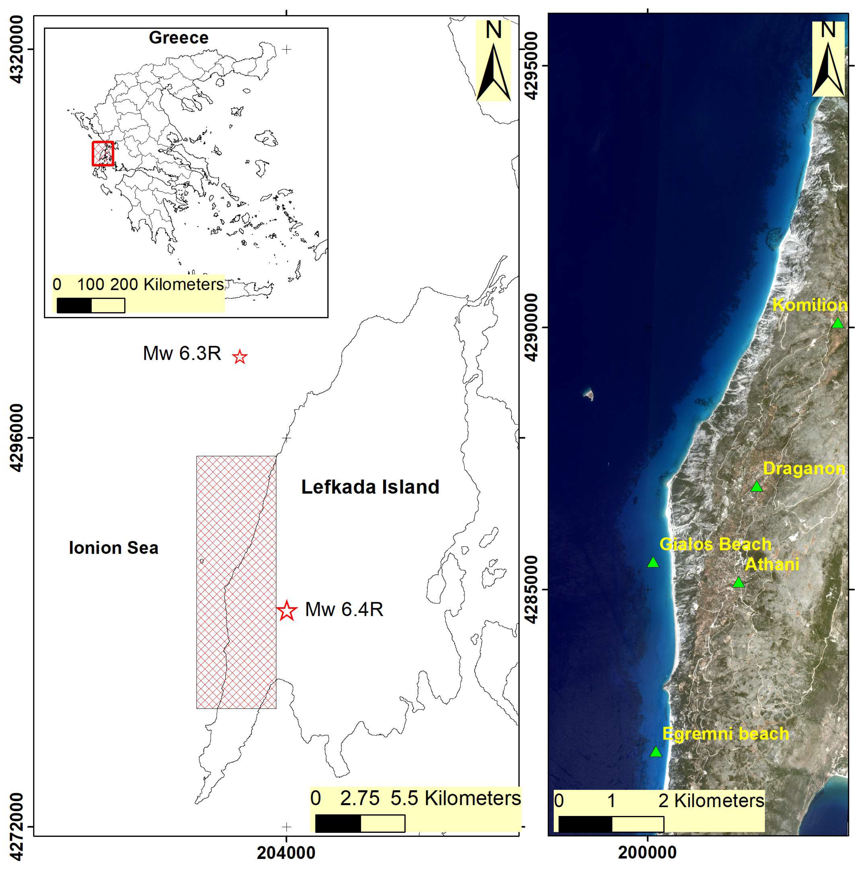
2.1. Study Area
2.2. Materials
2.2.1. Remote Sensing Data
2.2.2. Field Data
2.3. Methodology
3. Results
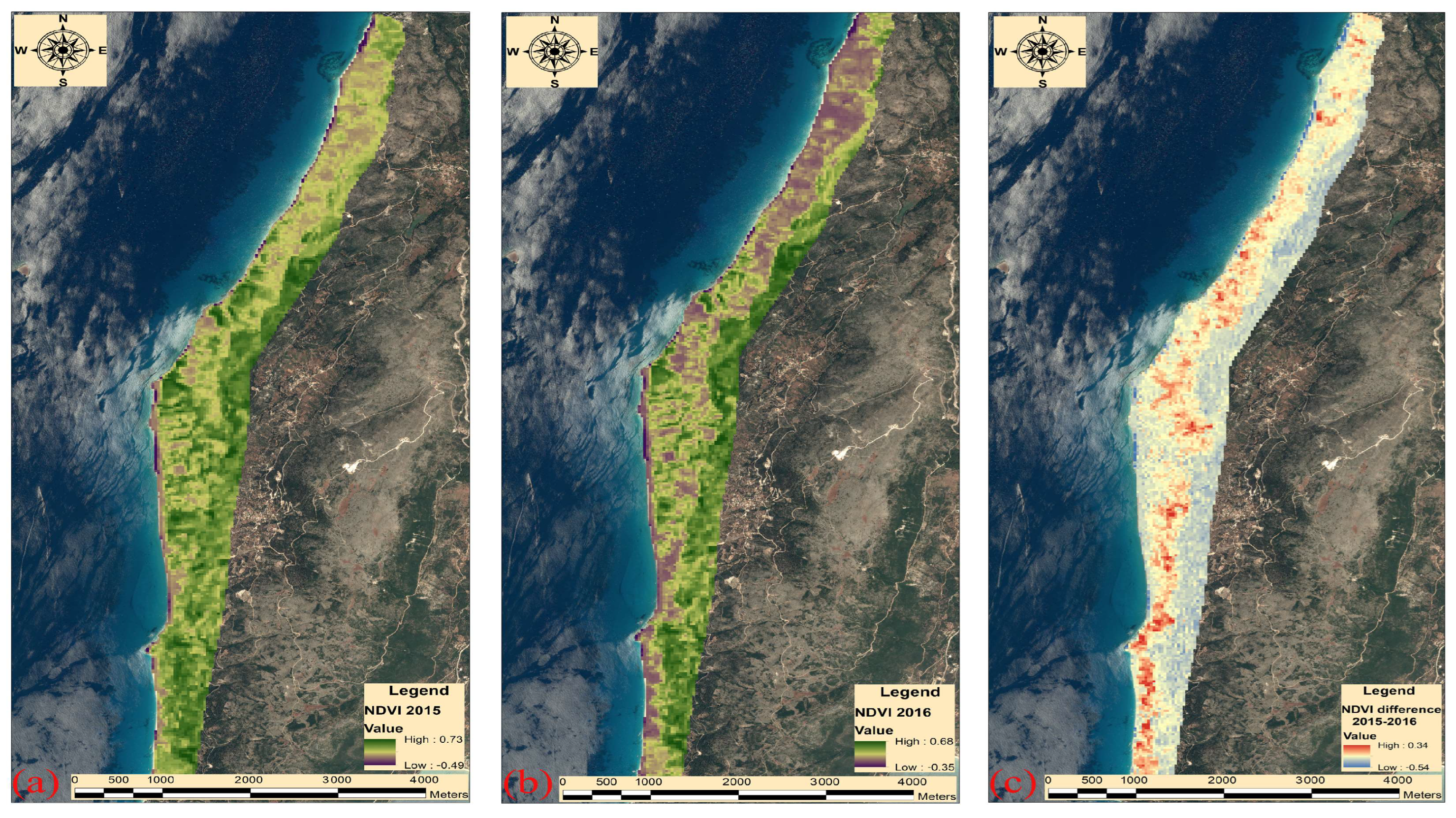
3.1. Google Earth Engine
3.2. High-Resolution Remote Sensing Data
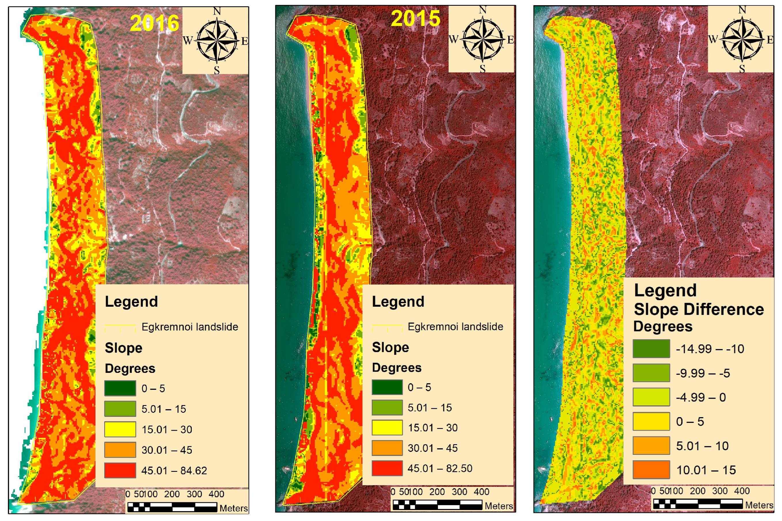
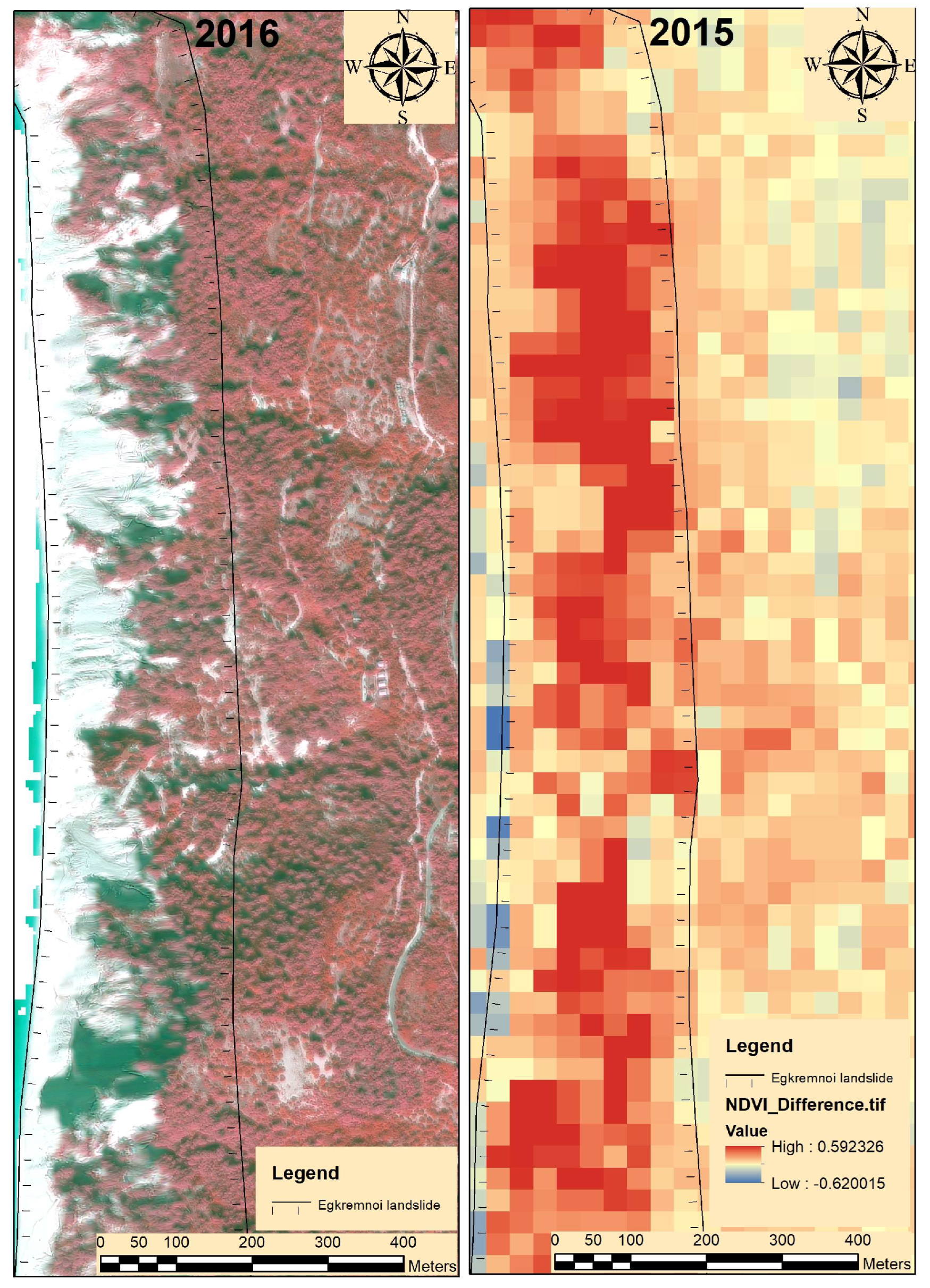
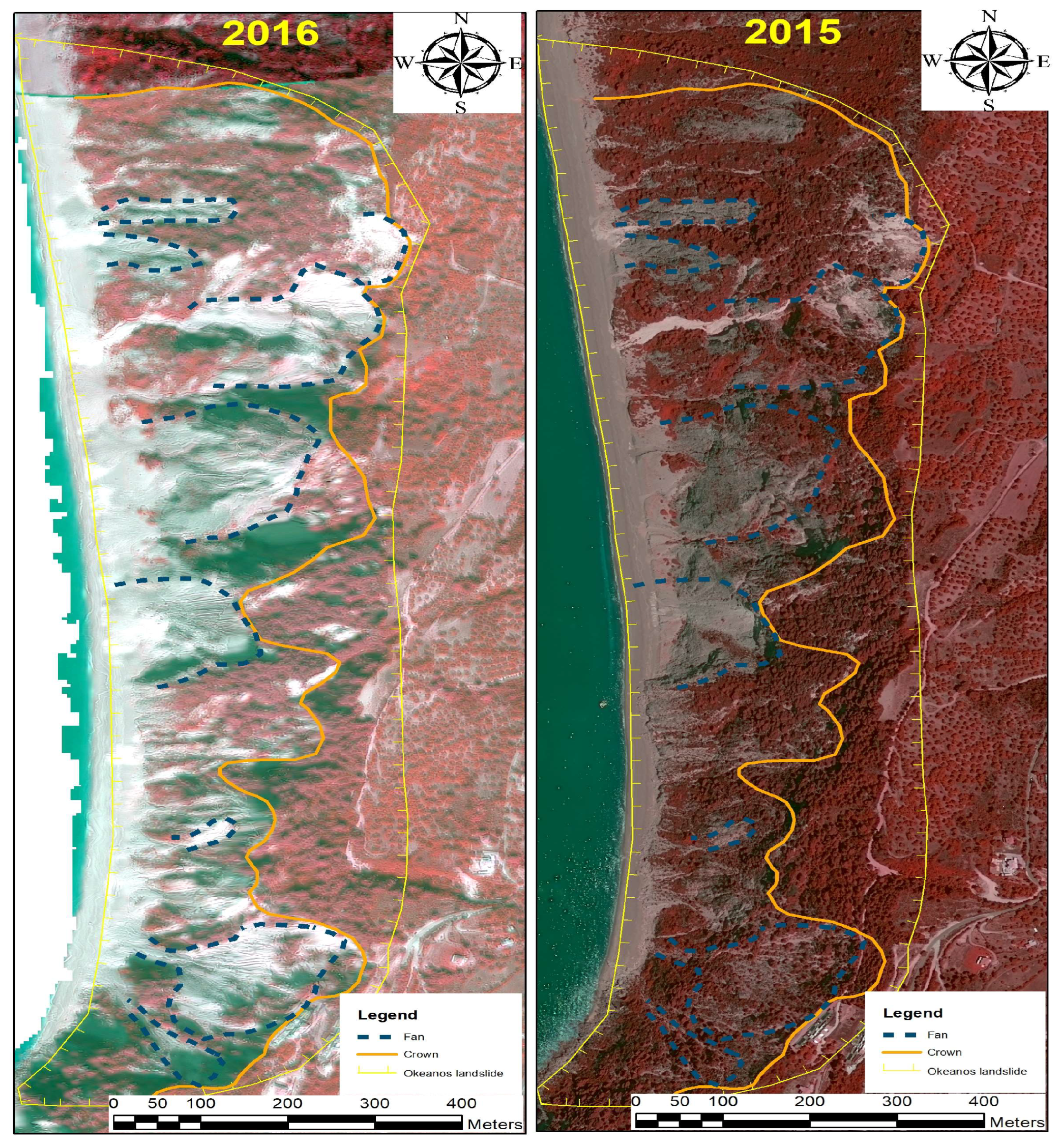
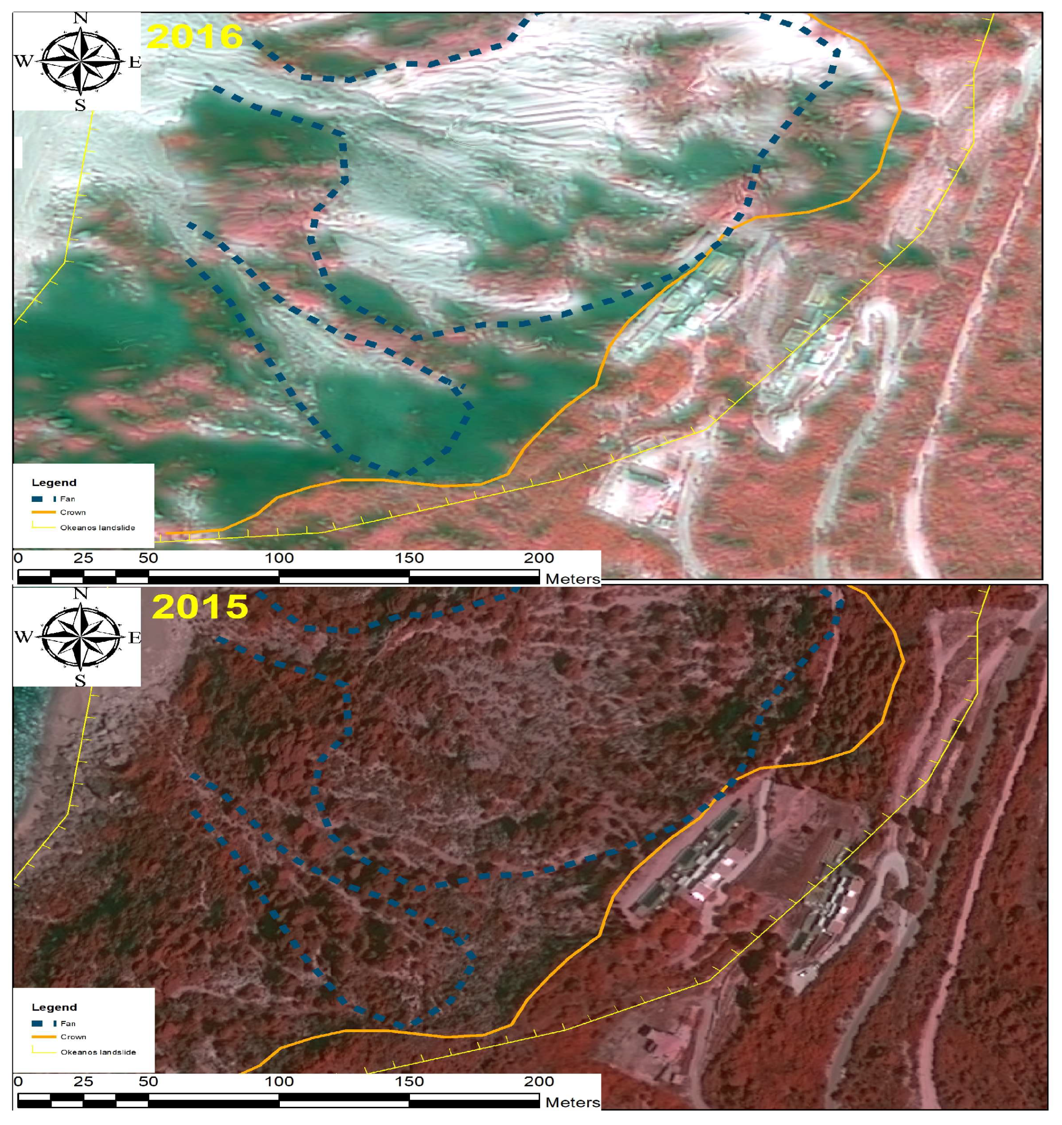
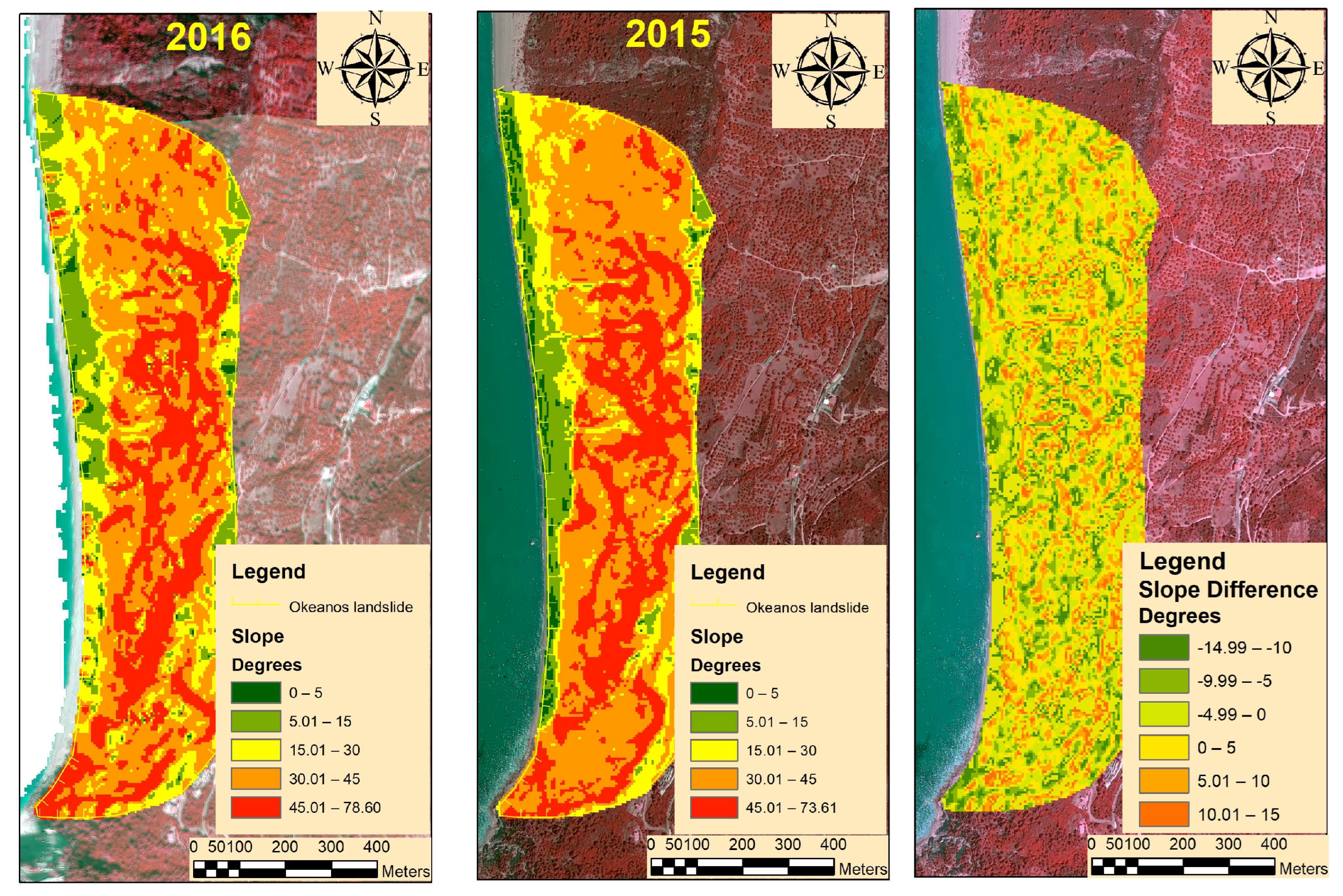
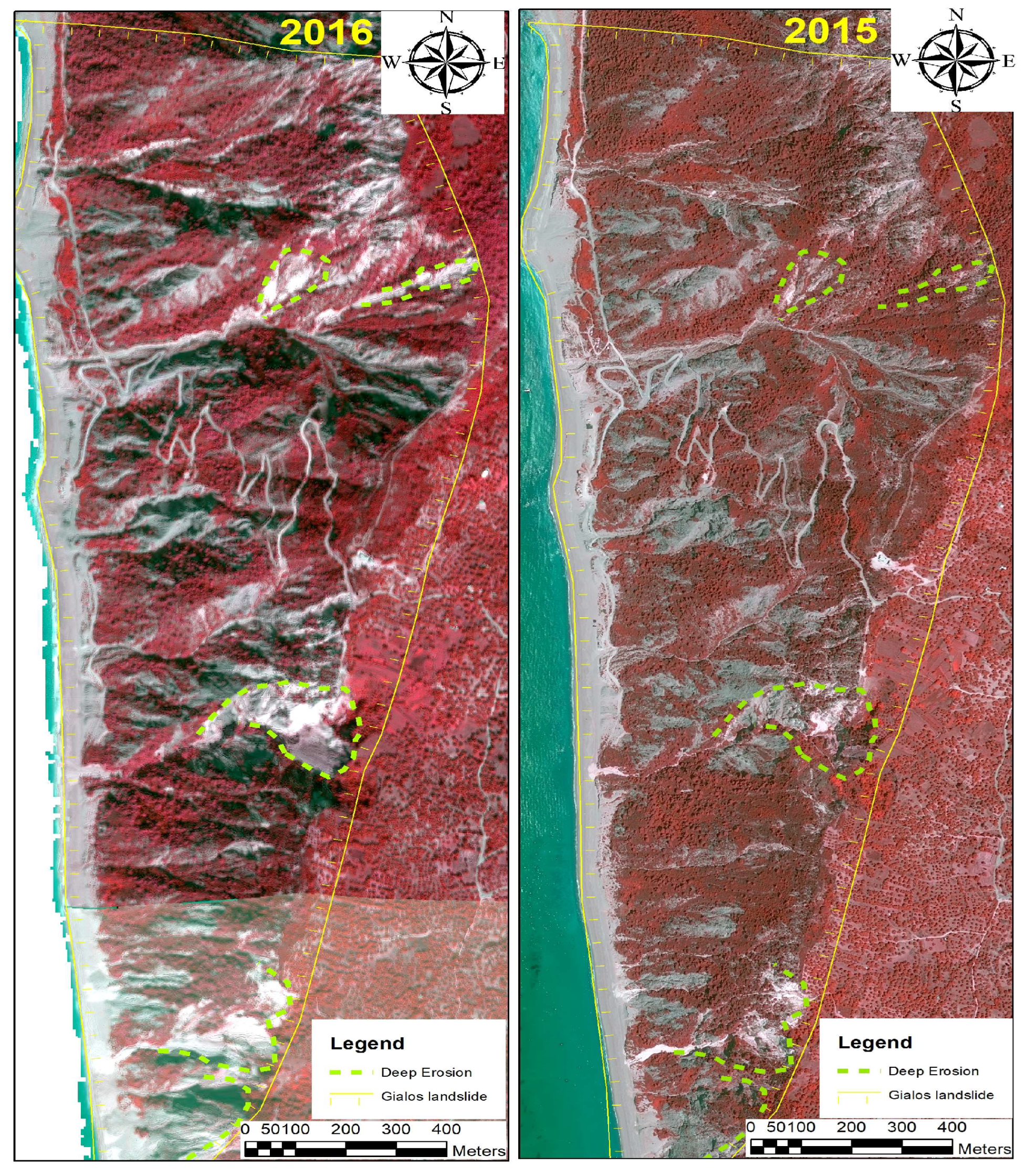
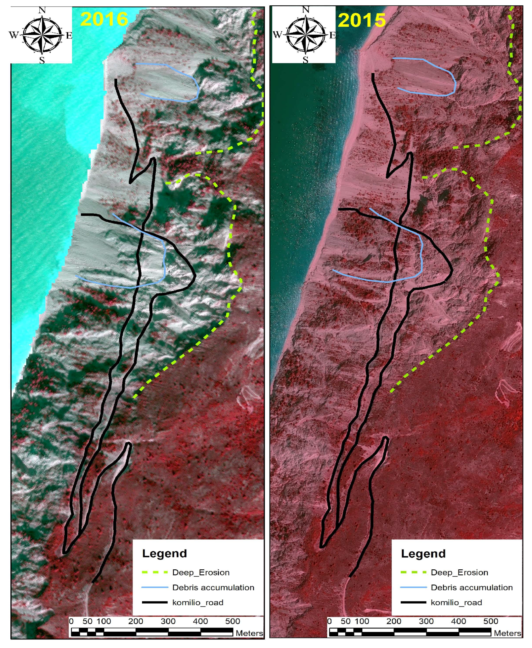
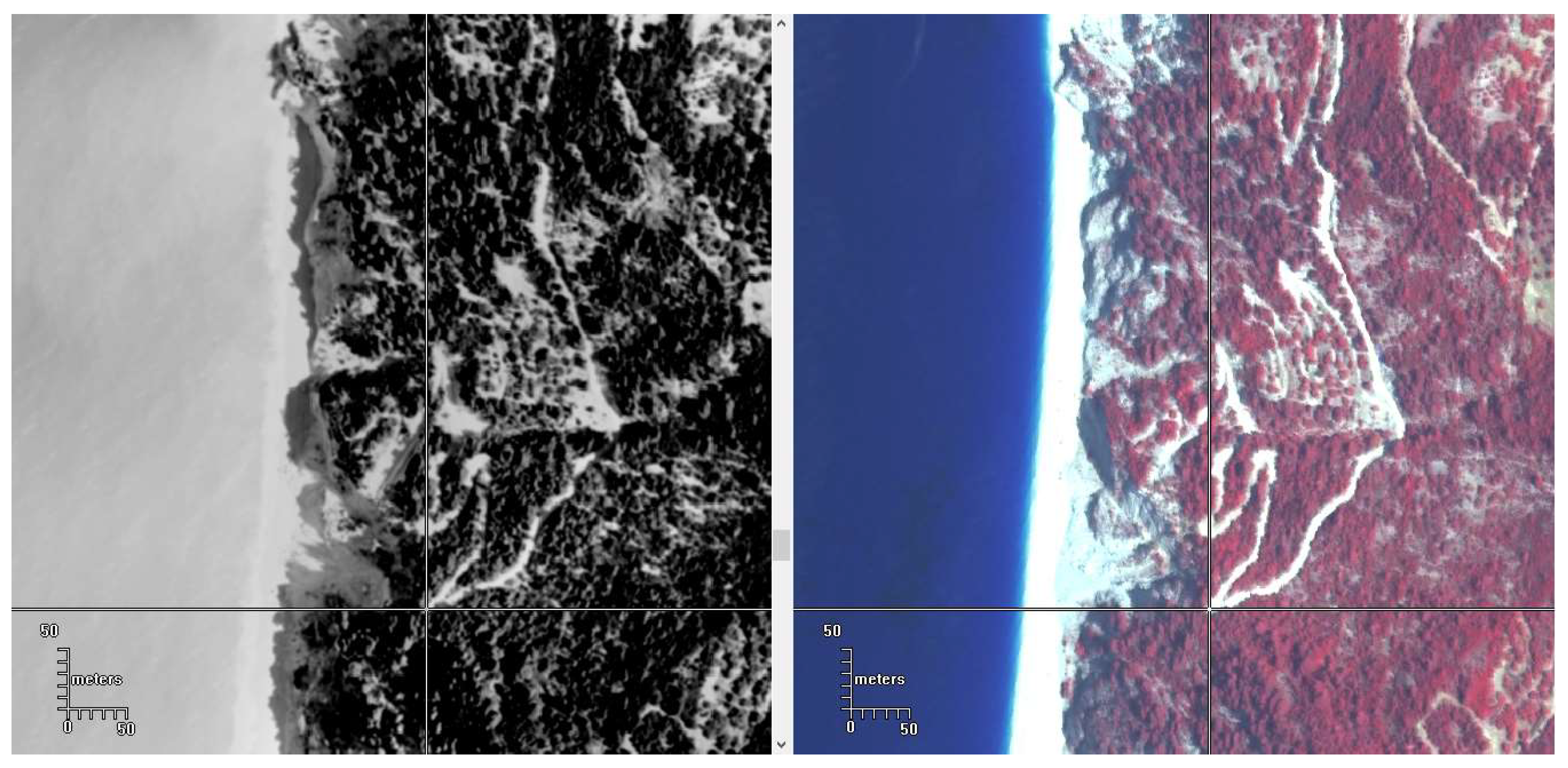
3.2.1. Change Detection
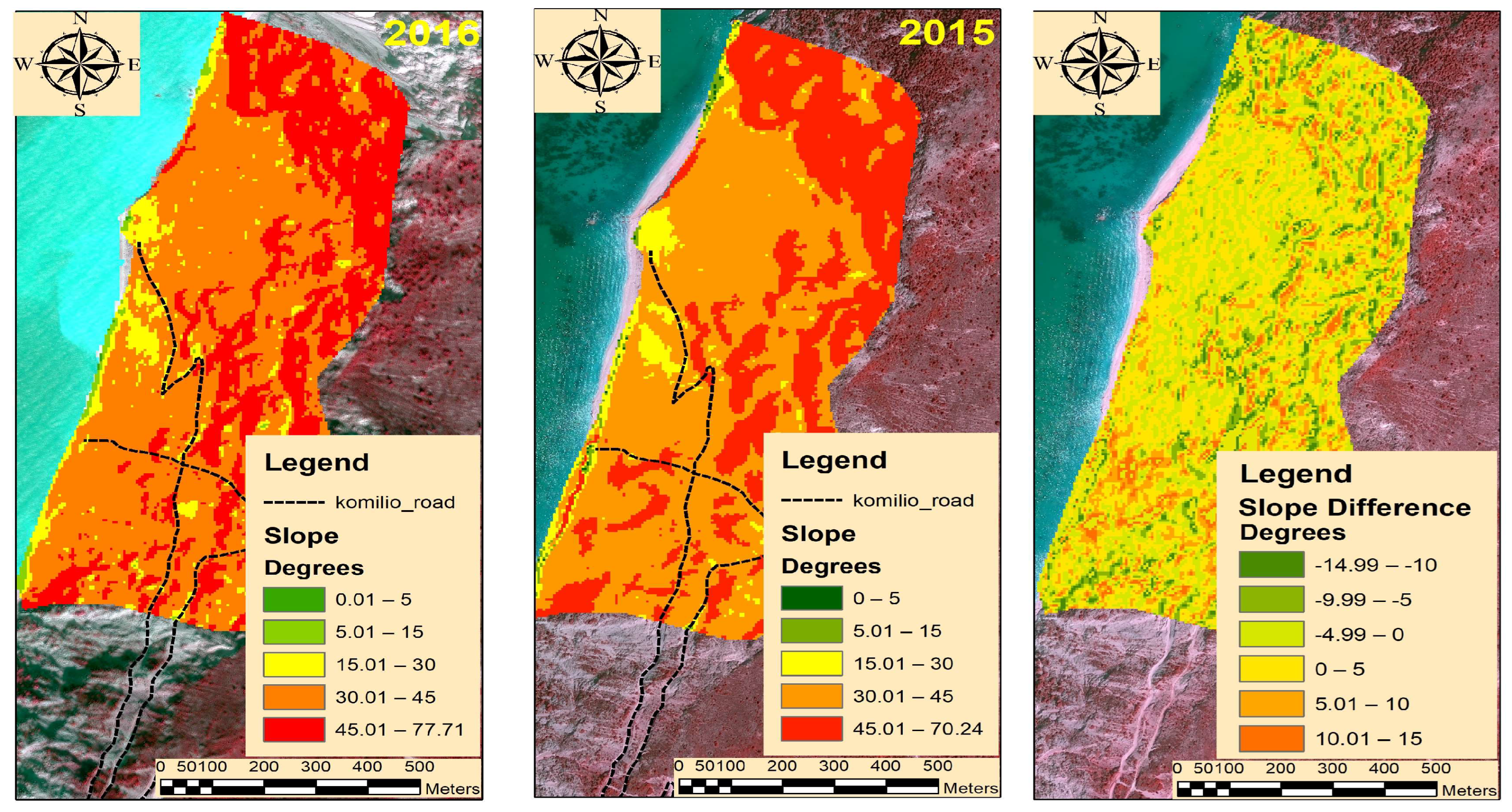
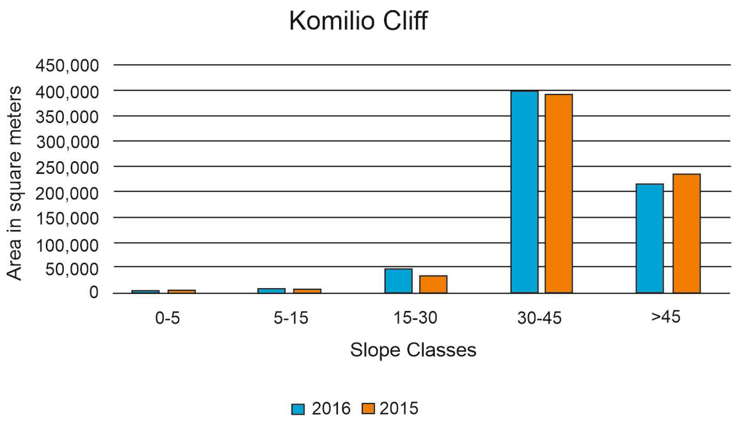
3.2.2. Numerical Evaluation of the Changes
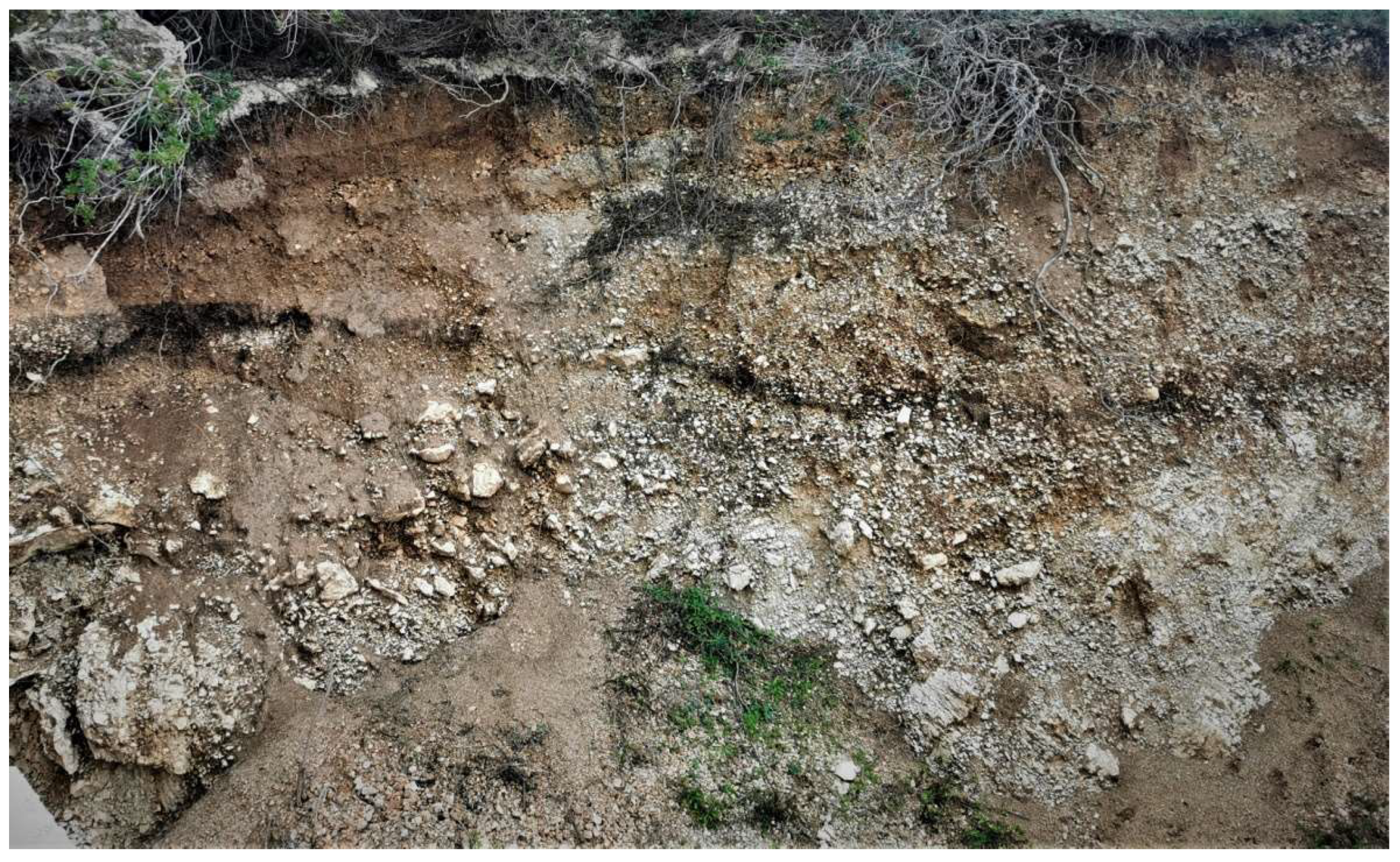
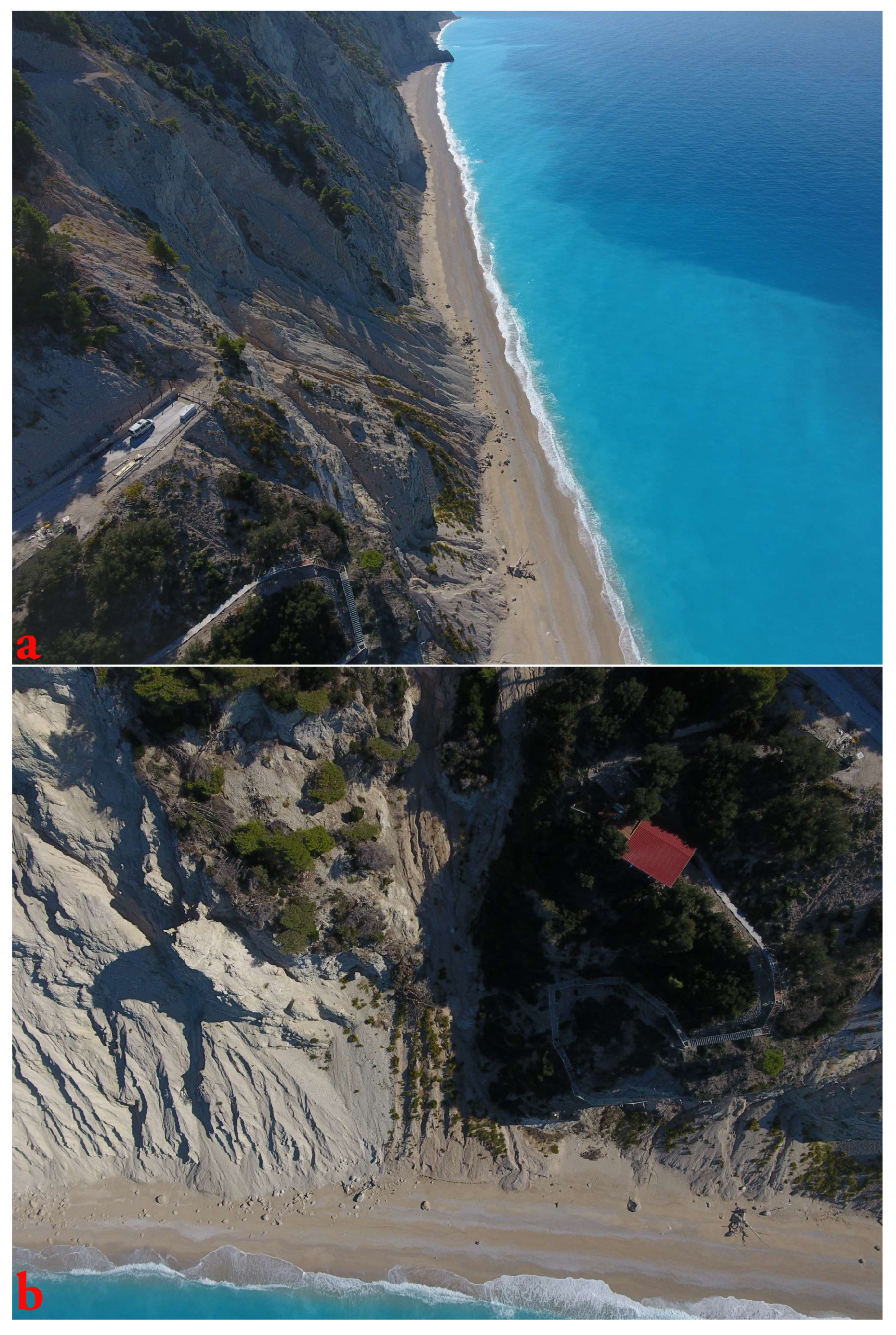
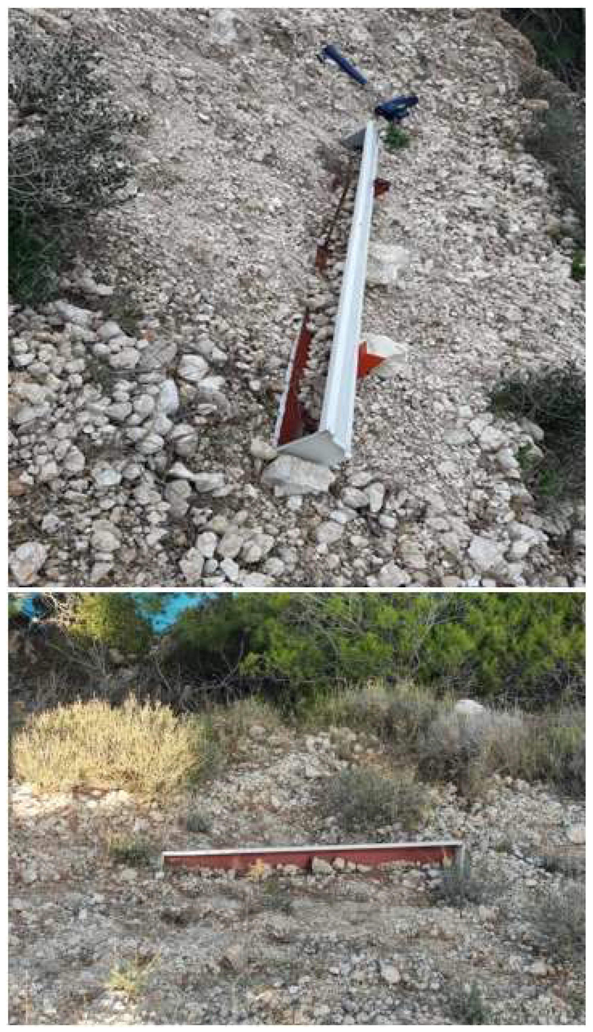
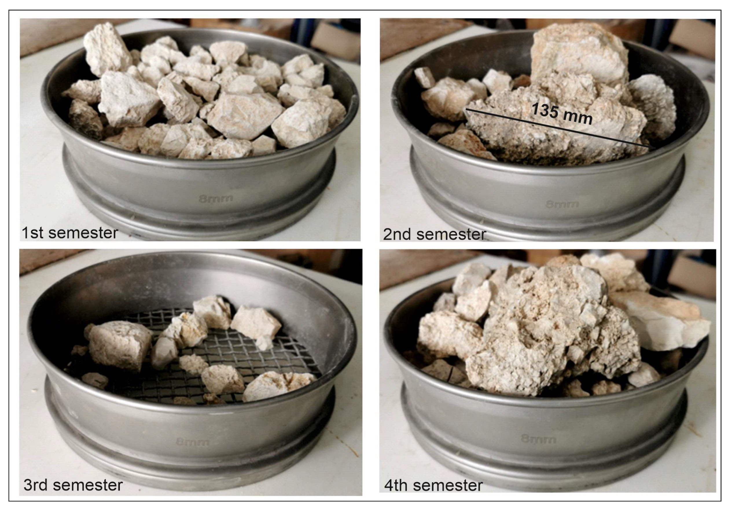
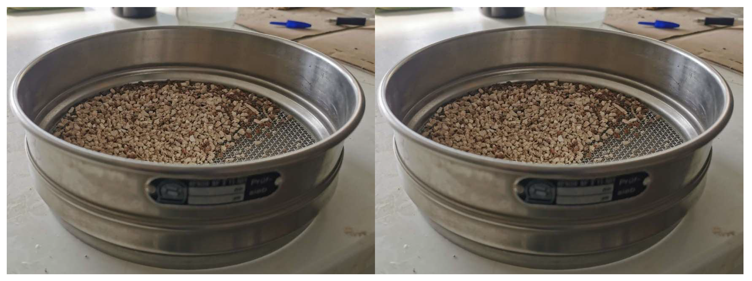
3.3. Field Data
4. Discussion
5. Conclusions
- The evolution of the Lefkada western coast is strongly related to seismicity.
- Both the 2003 and 2015 earthquakes provoked inclination changes, vegetation loss, and mass movements.
- Minor earthquakes (magnitudes < 4.1) contribute to the evolution of the cliff.
- Since there are no wildfires or timber harvesting activities in the study area, the landform response to earthquakes is stronger than the climatic factors. Hence, heavy rain and wind are less influential in slope erosion and the cliff than the inter-seismic earthquake activity.
- Remote sensing data and sediment trap can be combined successfully, leading to a more comprehensive understanding of the on-going processes.
- Medium resolution GEE products and high-resolution processing results can be used as supplementary information sources.
Supplementary Materials
Author Contributions
Funding
Institutional Review Board Statement
Informed Consent Statement
Data Availability Statement
Conflicts of Interest
References
- Sæmundsson, P.; Morino, C.; Helgason, J.K.; Conway, S.J.; Pétursson, H.G. The triggering factors of the Móafellshyrna debris slide in northern Iceland: Intense precipitation, earthquake activity and thawing of mountain permafrost. Sci. Total Environ. 2018, 621, 1163–1175. [Google Scholar] [CrossRef] [PubMed]
- Huang, R.; Fan, X. The landslide story. Nature Geosci. 2013, 6, 325–326. [Google Scholar] [CrossRef]
- Chen, J.; Che, A.; Wang, L. Cumulative damage evolution rule of rock slope based on shaking table test using VMD-HT. Eng. Geol. 2023, 314, 107003. [Google Scholar] [CrossRef]
- Zhou, H.; Che, A.; Zhu, R. Damage Evolution of Rock Slopes Under Seismic Motions Using Shaking Table Test. Rock Mech. Rock Eng. 2022, 55, 4979–4997. [Google Scholar] [CrossRef]
- Gischig, V.; Preisig, G.; Eberhardt, E. Numerical Investigation of Seismically Induced Rock Mass Fatigue as a Mechanism Contributing to the Progressive Failure of Deep-Seated Landslides. Rock Mech. Rock Eng. 2016, 49, 2457–2478. [Google Scholar] [CrossRef]
- Hack, R.; Alkema, D.; Kruse, G.A.M.; Leenders, N.; Luzi, L. Influence of earthquakes on the stability of slopes. Eng. Geol. 2007, 91, 4–15. [Google Scholar] [CrossRef]
- Meunier, P.; Hovius, N.; Haines, J.A. Topographic site effects and the location of earthquake-induced landslides. Earth Planet Sci. Lett. 2008, 275, 221–232. [Google Scholar] [CrossRef]
- Chang, K.T.; Chiang, S.H.; Hsu, M.L. Modeling typhoon- and earthquake-induced landslides in a mountainous watershed using logistic regression. Geomorphology 2007, 89, 335–347. [Google Scholar] [CrossRef]
- Tofani, V.; Segoni, S.; Agostini, A.; Catani, F.; Casagli, N. Technical Note: Use of remote sensing for landslide studies in Europe. Nat. Hazards Earth Syst. Sci. 2013, 13, 299–309. [Google Scholar] [CrossRef]
- Casagli, N.; Frodella, W.; Morelli, S.; Tofani, V.; Ciampalini, A.; Intrieri, E.; Raspini, F.; Rossi, G.; Tanteri, L.; Lu, P. Spaceborne, UAV and ground-based remote sensing techniques for landslide mapping, monitoring and early warning. Geoenviron. Disasters 2017, 4, 9. [Google Scholar]
- Liu, X.; Zhao, C.; Zhang, Q.; Peng, J.; Zhu, W.; Lu, Z. Multi-temporal loess landslide inventory mapping with C-, X- and L-band SAR datasets-a case study of Heifangtai loess landslides, China. Remote Sens. 2018, 10, 1756. [Google Scholar] [CrossRef]
- Aimaiti, Y.; Liu, W.; Yamazaki, F.; Maruyama, Y. Earthquake-Induced Landslide Mapping for the 2018 Hokkaido Eastern Iburi Earthquake Using PALSAR-2 Data. Remote Sens. 2019, 11, 2351. [Google Scholar] [CrossRef]
- Niethammer, U.; James, M.R.; Rothmund, S.; Travelletti, J.; Joswig, M. UAV-based remote sensing of the super-Sauze landslide: Evaluation and results. Eng. Geol. 2012, 128, 2–11. [Google Scholar] [CrossRef]
- Peternel, T.; Kumelj, Š.; Oštir, K.; Komac, M. Monitoring the Potoška planina landslide (NW Slovenia) using UAV photogrammetry and tachymetric measurements. Landslides 2017, 14, 395–406. [Google Scholar] [CrossRef]
- Saito, H.; Uchiyama, S.; Hayakawa, Y.S.; Obanawa, H. Landslides triggered by an earthquake and heavy rainfalls at Aso volcano, Japan, detected by UAS and SfM-MVS photogrammetry. Prog. Earth Planet Sci. 2018, 5, 15. [Google Scholar] [CrossRef]
- Wang, X.; Fan, X.; Xu, Q.; Du, P. Change detection-based co-seismic landslide mapping through extended morphological profiles and ensemble strategy. ISPRS J. Photogramm. Remote Sens. 2022, 187, 225–239. [Google Scholar] [CrossRef]
- Shao, X.; Ma, S.; Xu, C.; Zhang, P.; Wen, B.; Tian, Y.; Zhou, Q.; Cui, Y. Planet Image-Based Inventorying and Machine Learning-Based Susceptibility Mapping for the Landslides Triggered by the 2018 Mw6.6 Tomakomai, Japan Earthquake. Remote Sens. 2019, 11, 978. [Google Scholar] [CrossRef]
- Pokharel, B.; Alvioli, M.; Lim, S. Assessment of earthquake-induced landslide inventories and susceptibility maps using slope unit-based logistic regression and geospatial statistics. Sci. Rep. 2021, 11, 21333. [Google Scholar] [CrossRef]
- Zhang, S.; Wang, Y.; Wu, G. Earthquake-Induced Landslide Susceptibility Assessment Using a Novel Model Based on Gradient Boosting Machine Learning and Class Balancing Methods. Remote Sens. 2022, 14, 5945. [Google Scholar] [CrossRef]
- Koukouvelas, I.Κ.; Nikolakopoulos, K.G.; Zygouri, V.; Kyriou, A. Post-seismic monitoring of cliff mass wasting using an unmanned aerial vehicle and field data at Egremni, Lefkada Island, Greece. Geomorphology 2020, 367, 107306. [Google Scholar] [CrossRef]
- Nikolakopoulos, K.; Kyriou, A.; Koukouvelas, I.; Zygouri, V.; Apostolopoulos, D. Combination of Aerial, Satellite, and UAV Photogrammetry for Mapping the Diachronic Coastline Evolution: The Case of Lefkada Island. ISPRS Int. J. Geo-Inf. 2019, 8, 489. [Google Scholar] [CrossRef]
- Båth, M. The seismology of Greece. Tectonophysics 1983, 98, 165–208. [Google Scholar] [CrossRef]
- Caputo, R.; Chatzipetros, A.; Pavlides, S.; Sboras, S. The Greek Database of Seismogenic Sources (GreDaSS): State-of-the-art for northern Greece. Ann. Geophys. 2013, 55, 859–894. [Google Scholar] [CrossRef]
- Karakostas, V.; Papadimitriou, E.; Patias, P.; Georgiadis, C. Coastal deformation in Lefkada Island associated with strong earthquake occurrence. Boll. Di Geofis. Teor. Ed Appl. 2019, 60, 1–16. [Google Scholar] [CrossRef]
- Hatzfeld, D.; Kassaras, I.; Panagiotopoulos, D.; Amorese, D.; Makropoulos, K.; Karakaisis, G.; Coutant, O. Microseismicity and strain pattern in northwestern Greece. Tectonics 1995, 14, 773–785. [Google Scholar] [CrossRef]
- Ganas, A.; Marinou, A.; Anastasiou, D.; Paradissis, D.; Papazissi, K.; Tzavaras, P.; Drakatos, G. GPS-derived estimates of crustal deformation in the central and north Ionian Sea, Greece: 3-yr results from NOANET continuous network data. J. Geod. 2013, 6, 62–71. [Google Scholar]
- Clement, C.; Hirn, A.; Charvis, P. Seismic structure and the active Hellenic subduction in the Ionian islands. Tectonics 2000, 329, 141–156. [Google Scholar] [CrossRef]
- Louvari, E.; Kiratzi, A.; Papazachos, B. The Cephalonia Transform Fault and its extension to western Lefkada Island (Greece). Tectonophysics 1999, 308, 223–236. [Google Scholar] [CrossRef]
- Kokinou, E.; Papadimitriou, E.; Karakostas, V.; Kamberis, E.; Vallianatos, F. The Kefalonia Transform Zone (offshore Western Greece) with special emphasis to its prolongation towards the Ionian Abyssal Plain. Mar. Geophys. Res. 2006, 27, 241–252. [Google Scholar] [CrossRef]
- Kokkalas, S.; Xypolias, P.; Koukouvelas, I.K.; Doutsos, T. Post-Collisional Contractional and Extensional Deformation in the Aegean Region. In Post-Collisional Tectonics and Magmatism in the Mediterranean region and Asia; Dilek, Y., Pavlides, S., Eds.; Geological Society of America Special Paper; The Geological Society of America: Boulder, CO, USA, 2006; Volume 409, pp. 97–123. [Google Scholar]
- Papadopoulos, G.A.; Plessa, A. Magnitude-distance relations for earthquake-induced landslides in Greece. Eng. Geol. 2000, 58, 377–386. [Google Scholar] [CrossRef]
- Bornovas, J. Géologie de l’ île de Lefkade. Geol. Geophys. Res. 1964, 10, 142. [Google Scholar]
- Cushing, M. Evolution Structurale de la Marge Nord-Ouest Hellénique Dans l’île de Lefkas et ses Environs (Grèce Nord-Occidentale). Ph.D. Thesis, Univ. d’ Orsay, Orsay, France, 1985. [Google Scholar]
- Karakostas, V.G. Properties of the 2003 Lefkada, Ionian Islands, Greece, Earthquake Seismic Sequence and Seismicity Triggering. Bull. Seismol. Soc. Am. 2004, 94, 1976–1981. [Google Scholar] [CrossRef]
- Zahradnik, J.; Serpetsidaki, A.; Sokos, E.; Tselentis, G.-A. Iterative Deconvolution of Regional Waveforms and a Double-Event Interpretation of the 2003 Lefkada Earthquake, Greece. Bull. Seismol. Soc. Am. 2005, 95, 159–172. [Google Scholar] [CrossRef]
- Benetatos, C.; Dreger, D.; Kiratzi, A. Complex and Segmented Rupture Associated with the 14 August 2003 Mw 6.2 Lefkada, Ionian Islands, Earthquake. Bull. Seismol. Soc. Am. 2007, 97, 35–51. [Google Scholar] [CrossRef]
- Sokos, E.; Zahradník, J.; Gallovic, F.; Serpetsidaki, A.; Plicka, V.; Kiratzi, A. Asperity break after 12 years: The Mw6.4 2015 Lefkada (Greece) earthquake. Geophys. Res. Lett. 2016, 43, 6137–6145. [Google Scholar] [CrossRef]
- Ganas, A.; Elias, P.; Bozionelos, G.; Papathanassiou, G.; Avallone, A.; Papastergios, A.; Valkaniotis, S.; Parcharidis, I.; Briole, P. Coseismic deformation, field observations and seismic fault of the 17 November 2015 M = 6.5, Lefkada Island, Greece earthquake. Tectonophysics 2016, 687, 210–222. [Google Scholar] [CrossRef]
- Bie, L.; González, P.J.; Rietbrock, A. Slip distribution of the 2015 Lefkada earthquake and its implications for fault segmentation. Geoph. Jour. Int. 2017, 210, 420–427. [Google Scholar] [CrossRef]
- Chousianitis, K.; Konca, A.O.; Tselentis, G.A.; Papadopoulos, G.A.; Gianniou, M. Slip model of the 17 November 2015 Mw =6.5 Lefkada earthquake from the joint inversion of geodetic and seismic data. Geophys. Res. Lett. 2016, 43, 7973–7981. [Google Scholar] [CrossRef]
- Melgar, D.; Ganas, A.; Geng, J.; Liang, C.; Fielding, E.J.; Kassaras, I. Source characteristics of the 2015 Mw6.5Lefkada, Greece, strike-slip earthquake. J. Geophys. Res. Solid Earth 2017, 122, 2260–2273. [Google Scholar]
- Svigkas, N.; Atzori, S.; Kiratzi, A.; Tolomei, C.; Antonioli, A.; Papoutsis, I.; Salvi, S.; Kontoes, C. On the Segmentation of the Cephalonia–Lefkada Transform Fault Zone (Greece) from an InSAR Multi-Mode Dataset of the Lefkada 2015 Sequence. Remote Sens. 2019, 11, 1848. [Google Scholar] [CrossRef]
- Papathanassiou, G.; Valkaniotis, S.; Ganas, A.; Grendas, N.; Kollia, E. The November 17th, 2015 Lefkada (Greece) strike-slip earthquake: Field mapping of generated failures and assessment of macroseismic intensity ESI-07. Eng. Geol. 2015, 220, 13–30. [Google Scholar] [CrossRef]
- Kassaras, I.; Kazantzidou-Firtinidou, D.; Ganas, A.; Tonna, S.; Pomonis, A.; Karakostas, C.; Papadatou-Giannopoulou, C.; Psarris, D.; Lekkas, E.; Makropoulos, K. On the Lefkas (Ionian Sea) November 17, 2015 Mw = 6.5 Earthquake Macroseismic Effects. J. Earthq. Eng. 2018, 24, 1913–1943. [Google Scholar] [CrossRef]
- Lekkas, E.; Mavroulis, S.; Carydis, P.; Alexoudi, V. The 17 November 2015 Mw 6.4 Lefkas (Ionian Sea, Western Greece) Earthquake: Impact on Environment and Buildings. Geotech. Geol. Eng. 2018, 36, 2109–2142. [Google Scholar] [CrossRef]
- Polykretis, C.; Kalogeropoulos, K.; Andreopoulos, P.; Faka, A.; Tsatsaris, A.; Chalkias, C. Comparison of Statistical Analysis Models for Susceptibility Assessment of Earthquake-Triggered Landslides: A Case Study from 2015 Earthquake in Lefkada Island. Geosciences 2019, 9, 350. [Google Scholar] [CrossRef]
- Servou, A.; Vagenas, N.; Depountis, N.; Roumelioti, Z.; Sokos, E.; Sabatakakis, N. Rockfall Intensity under Seismic and Aseismic Conditions: The Case of Lefkada Island, Greece. Land 2023, 12, 172. [Google Scholar] [CrossRef]
- Tsangaratos, P.; Loupasakis, C.; Nikolakopoulos, K.G.; Angelitsa, V.; Ilia, I. Developing a landslide susceptibility map based on remote sensing, fuzzy logic and expert knowledge of the Island of Lefkada, Greece. Environ. Earth Sci. 2018, 77, 1–23. [Google Scholar]
- Nikolakopoulos, K.G.; Soura, K.; Koukouvelas, I.K.; Argyropoulos, N.G. UAV vs classical aerial photogrammetry for archaeological studies. J. Archaeol. Sci. Rep. 2017, 14, 758–773. [Google Scholar] [CrossRef]
- Rice, R.M. Sedimentation in the chaparral: How do you handle unusual events? In Sediment Budgets and Routing in Forested Drainage Basins; Swanson, F.J., Ed.; U.S. Department of Agriculture: Washington, DC, USA, 1982; pp. 39–49. [Google Scholar]
- Gabet, E.J. Sediment transport by dry ravel. J. Geophys. Res. 2003, 108, 2049. [Google Scholar] [CrossRef]
- Yang, X.; Chen, L. Using multi-temporal remote sensor imagery to detect earthquake-triggered landslides. Int. J. Appl. Earth Obs. Geoinf. 2010, 12, 487–495. [Google Scholar] [CrossRef]
- Xu, C. Preparation of earthquake-triggered landslide inventory maps using remote sensing and GIS technologies: Principles and case studies. Geosci. Front. 2015, 6, 825–836. [Google Scholar] [CrossRef]
- Huang, Y.; Zhang, J.; Zhang, L.; Ming, Z.; He, H.; Chen, R.; Ge, Y.; Liu, R. How Spatial Resolution of Remote Sensing Image Affects Earthquake Triggered Landslide Detection: An Example from 2022 Luding Earthquake, Sichuan, China. Land 2023, 12, 681. [Google Scholar] [CrossRef]
- Liu, W.; Yamazaki, F. Detection of landslides due to the 2013 Thypoon Wipha from high-resolution airborne SAR images. In Proceedings of the 2015 IEEE International Geoscience and Remote Sensing Symposium (IGARSS), Milan, Italy, 26–31 July 2015; pp. 4244–4247. [Google Scholar] [CrossRef]
- Plank, S.; Twele, A.; Martinis, S. Landslide Mapping in Vegetated Areas Using Change Detection Based on Optical and Polarimetric SAR Data. Remote Sens. 2016, 8, 307. [Google Scholar] [CrossRef]
- Wu, B.S.; Chuang, R.Y.; Chen, Y.C. Characteristics of landslides triggered by the 2013 ML6.5 Nantou, Taiwan, earthquake. Earth Planets Space 2022, 74, 7. [Google Scholar] [CrossRef]
- Hapke, C.; Richmond, B. The impact of climatic and seismic events on the short-term evolution of seacliffs based on 3-D mapping: Northern Monterey Bay, California. Mar. Geol. 2002, 187, 259–278. [Google Scholar] [CrossRef]
- Zhou, Y.; Parsons, B.; Elliott, J.R.; Barisin, I.; Walker, R.T. Assessing the ability of Pleiades stereo imagery to determine height changes in earthquakes: A case study for the El Mayor-Cucapah epicentral area. J. Geophys. Res. Solid Earth 2015, 120, 8793–8808. [Google Scholar] [CrossRef]
- Bloom, C.K.; Singeisen, C.; Stahl, T.; Howell, A.; Massey, C. Earthquake Contributions to Coastal Cliff Retreat. EGUsphere 2022. [Google Scholar] [CrossRef]
- Naylor, L.A.; Stephenson, W.J.; Trenhaile, A.S. Rock coast geomorphology: Recent advances and future reasearch directions. Geomorphology 2009, 114, 3–11. [Google Scholar] [CrossRef]
- Griggs, G.; Plant, N. Coastal-bluff failures in northern Monterey Bay induced by the earthquake. In The Loma Prieta, California, Earthqukae of October 17, 1989; Landslides US Geological Survey Professional Paper; Government Printing Office: Washington, DC, USA, 1998; Volume 1551–C, pp. 51–70. [Google Scholar]
- Gallousi, C.; Koukouvelas, I.K. Quantifying geomorphic evolution of earthquake-triggered landslides and their relation to active normal faults. An example from the Gulf of Corinth, Greece. Tectonophysics 2007, 440, 85–104. [Google Scholar] [CrossRef]
- Keefer, D.K. Landslides caused by earthquakes. Bull. Geol. Soc. Am. 1984, 95, 406–421. [Google Scholar] [CrossRef]
- Sørensen, M.B.; Haga, T.; Nesje, A. Earthquake-induced landslides in Norway. Nat. Hazards Earth Syst. Sci. 2023, 23, 1577–1592. [Google Scholar] [CrossRef]
- Wistuba, M.; Malik, I.; Krzemień, K.; Gorczyca, E.; Sobucki, M.; Wrońska-Wałach, D.; Gawior, D. Can low-magnitude earthquakes act as a triggering factor for landslide activity? Examples from the Western Carpathian Mts, Poland. Catena 2018, 171, 359–375. [Google Scholar] [CrossRef]
- Koukouvelas, I.; Mpresiakas, A.; Sokos, E.; Doutsos, T. The tectonic setting and earthquake hazards of the 1993 Pyrgos earthquake, Peloponnese, Greece. J. Geol. Soc. Lond. 1996, 153, 39–49. [Google Scholar] [CrossRef]


| Year | Data | Source | Number of Photos | Spatial Resolution | Type |
|---|---|---|---|---|---|
| 2000 | IKONOS bundle imagery | USGS | 1 | 1.00 m | Digital |
| 2004 | Airphotos | 20 | 1.00 m | Analogue | |
| 2008 | Orthomosaic | 1 | 0.50 m | Digital | |
| 2008 | DSM | 5.00 m | Digital | ||
| 2015 | Pleiades bundle | 1 | 0.50 m | Digital | |
| 2016 | Pleiades stereo pair | 1 | 0.50 m | Digital | |
| 2003 | Landsat-5 | Multiple | 30.00 m | Digital | |
| 2004 | Landsat-5 | Multiple | 30.00 m | Digital | |
| 2015 | Landsat-8 | Multiple | 30.00 m | Digital | |
| 2016 | Landsat-8 | Multiple | 30.00 m | Digital |
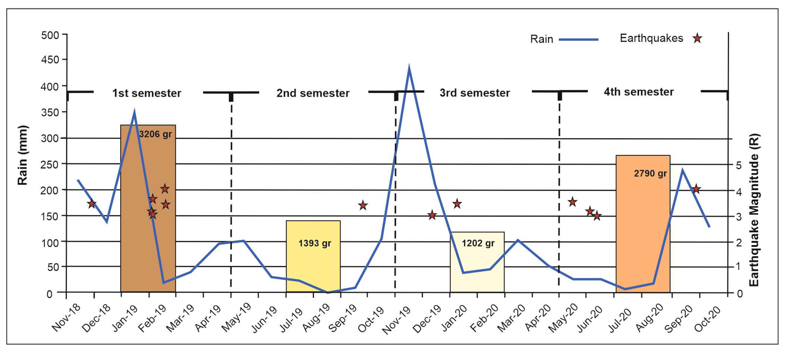
| Sampling Periods | Sediment Weight | Precipitation (mm) | Earthquakes in R | Earthquake Energy Release (Joules) |
|---|---|---|---|---|
| 3 November 2018–30 April 2019 1st semester | 3206 g/or 534 g/month | 856.50 | 3.4, 3.7, 3.5, 4.1, 3 | 10.63 × 10⁻¹⁰ |
| 30 April 2019–9 November 2019 2nd semester | 1393 g/or 232 g/month | 263.9 | 3.4 | 1.36 × 10⁻¹⁰ |
| 9 November 2019–17 March 2020 3rd semester | 1202 g/or 240.4 g/month | 712.50 | 3.1, 3.5 | 2.4 × 10⁻¹⁰ |
| 17 March 2020–3 October 2020 4th semester | 2790 g/or 429.2 g/month | 468.8 | 3.6, 3.2, 3, 4.1 | 7.47 × 10⁻¹⁰ |
| Classification | First Semester 1 | Second Semester 1 | Third Semester 1 | Fourth Semester 1 |
|---|---|---|---|---|
| Medium gravel (8 mm+) | 2058 | 1387 | 1081 | 2232 |
| Fine gravel | 230 | 0 | 17 | 110 |
| Very fine gravel | 182 | 0 | 13 | 84 |
| Coarse sand | 270 | 2.3 | 22 | 131 |
| Medium Sand | 372 | 2.4 | 53 | 185 |
| Fine sand | 83 | 1.3 | 16 | 48 |
| Total weight | 3206 | 1393 | 1202 | 2790 |
Disclaimer/Publisher’s Note: The statements, opinions and data contained in all publications are solely those of the individual author(s) and contributor(s) and not of MDPI and/or the editor(s). MDPI and/or the editor(s) disclaim responsibility for any injury to people or property resulting from any ideas, methods, instructions or products referred to in the content. |
© 2023 by the authors. Licensee MDPI, Basel, Switzerland. This article is an open access article distributed under the terms and conditions of the Creative Commons Attribution (CC BY) license (https://creativecommons.org/licenses/by/4.0/).
Share and Cite
Nikolakopoulos, K.G.; Koukouvelas, I.K.; Kyriou, A.; Apostolopoulos, D.; Pappas, G. Evaluating the Impact of Seismic Activity on the Slope Stability of the Western Coast of Lefkada Island Using Remote Sensing Techniques, Geographical Information Systems, and Field Data. Appl. Sci. 2023, 13, 9434. https://doi.org/10.3390/app13169434
Nikolakopoulos KG, Koukouvelas IK, Kyriou A, Apostolopoulos D, Pappas G. Evaluating the Impact of Seismic Activity on the Slope Stability of the Western Coast of Lefkada Island Using Remote Sensing Techniques, Geographical Information Systems, and Field Data. Applied Sciences. 2023; 13(16):9434. https://doi.org/10.3390/app13169434
Chicago/Turabian StyleNikolakopoulos, Konstantinos G., Ioannis K. Koukouvelas, Aggeliki Kyriou, Dionysios Apostolopoulos, and George Pappas. 2023. "Evaluating the Impact of Seismic Activity on the Slope Stability of the Western Coast of Lefkada Island Using Remote Sensing Techniques, Geographical Information Systems, and Field Data" Applied Sciences 13, no. 16: 9434. https://doi.org/10.3390/app13169434
APA StyleNikolakopoulos, K. G., Koukouvelas, I. K., Kyriou, A., Apostolopoulos, D., & Pappas, G. (2023). Evaluating the Impact of Seismic Activity on the Slope Stability of the Western Coast of Lefkada Island Using Remote Sensing Techniques, Geographical Information Systems, and Field Data. Applied Sciences, 13(16), 9434. https://doi.org/10.3390/app13169434