GIS-Based Multi-Objective Routing Approach for Street-Based Sporting-Event Routing
Abstract
1. Introduction
1.1. Research Background
1.2. Literature Review
1.2.1. Limitations of the Street-Based Event-Planning Process
1.2.2. The Vehicle-Routing Problem with GIS
1.2.3. Route-Selection Factors: Route Variables and Environmental Variables
1.2.4. BIM on GIS
2. Methodology
2.1. Data Collection and Pre-Processing Approaches
2.2. Evaluation Model of Route-Selection Factors
2.3. Routing Framework
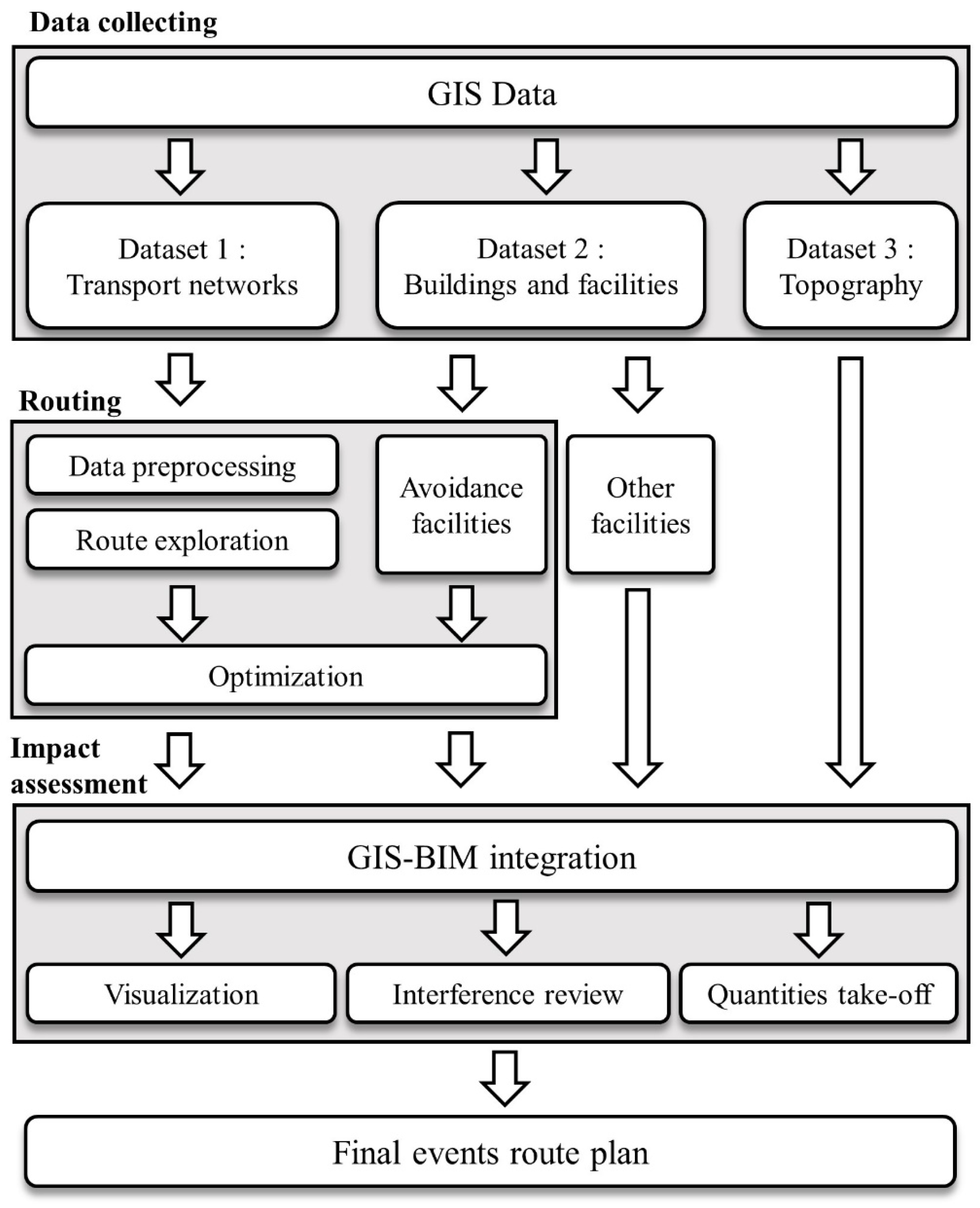
- If the width of the road was less than or equal to the required width of the track, we deleted the data from the route list.
- If the classification of the road route was bridge or tunnel, we deleted the data from the route list.
- If there was only one road adjacent to the avoidance facility defined in Section 3.2, we deleted the data from the route list.
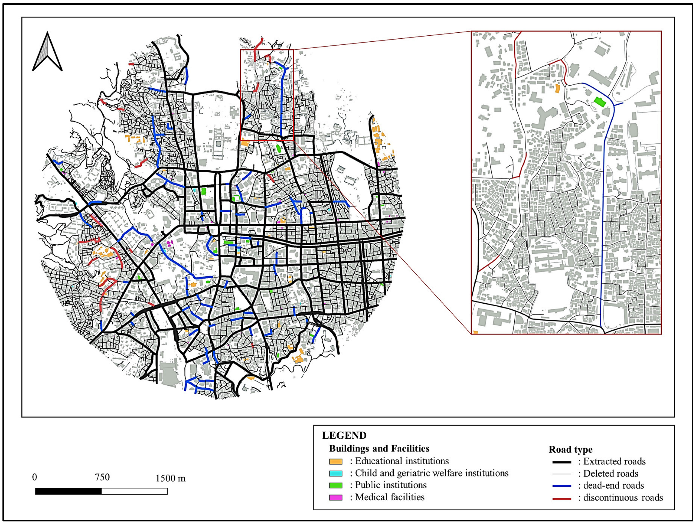
- We deleted completely discontinuous and dead-end roads that did not meet the criteria from the route list. Section 4 outlines the definitions of fully discontinuous and dead-end roads where the criteria were not met.
- The user inputs a node as the primary base. The event track is a closed path. Hence, a path that starts from the node and returns to it is searched. A routing algorithm randomly explores the path between all pairs of vertices in an edge-weighted directed graph and builds a regression path. If the width of the road exceeded twice the required width of the track, it was recognized as a turnaround route. However, it was not selected as a path if the turn radius of the turn node was not satisfied.
- We entered all studied regression routes into the GA process. The GAs apply genetic operations, such as population representation, selection, crossover, and mutation, to find optimal results for complex problems [48]. In order to define the optimal outcome, we evaluated the route by entering the weight for each parameter stated in Section 3.2. We then subjected the evaluated routes to genetic operations to create new offspring and find more optimized solutions.
- The derived optimal-route list was returned in the form of a closed curve.
2.4. GIS–BIM Integration and Impact Assessment
3. Results
3.1. Case Study: Project Description
3.2. Data Pre-Processing
3.3. Routing
3.4. GIS—BIM Integration
4. Discussion
5. Conclusions
Author Contributions
Funding
Institutional Review Board Statement
Informed Consent Statement
Data Availability Statement
Conflicts of Interest
References
- Smith, A. Events in the City: Using Public Spaces as Event Venues; Routledge: London, UK, 2015. [Google Scholar]
- McGillivray, D.; Guillard, S.; Reid, E. Urban Connective Action: The Case of Events Hosted in Public Space. Urban Plan. 2020, 5, 252–266. [Google Scholar] [CrossRef]
- Van Aalst, I.; van Melik, R. City festivals and urban development: Does place matter? Eur. Urban Reg. Stud. 2012, 19, 195–206. [Google Scholar] [CrossRef]
- Smith, A. Events and Urban Regeneration; Routledge: London, UK, 2012. [Google Scholar] [CrossRef]
- Amin, A. Collective culture and urban public space. City 2008, 12, 5–24. [Google Scholar] [CrossRef]
- FIA Formula E. ABB FIA Formula E World Championship. 2023. Available online: https://www.fiaformulae.com/en (accessed on 6 February 2023).
- Cao, Y.; Xu, C.; Aziz, N.M.; Kamaruzzaman, S.N. BIM–GIS Integrated Utilization in Urban Disaster Management: The Contributions, Challenges, and Future Directions. Remote Sens. 2023, 15, 1331. [Google Scholar] [CrossRef]
- Erdogan, S.; Yilmaz, I.; Baybura, T.; Gullu, M. Geographical information systems aided traffic accident analysis system case study: City of Afyonkarahisar. Accid. Anal. Prev. 2008, 40, 174–181. [Google Scholar] [CrossRef] [PubMed]
- Kumaresan, V.; Vasudevan, V.; Nambisan, S.S. Development of a GIS-Based Traffic Safety Analysis System. In Proceedings of the Annual ESRI International User Conference, San Diego, CA, USA, 13–17 July 2009. [Google Scholar]
- Liang, L.Y.; Ma’soem, D.M.; Hua, L.T. Traffic accident application using geographic information system. J. East. Asia Soc. Transp. Stud. 2005, 6, 3574–3589. [Google Scholar] [CrossRef]
- Rodrigues, D.S.; Ribeiro, P.J.G.; da Silva Nogueira, I.C. Safety classification using GIS in decision-making process to define priority road interventions. J. Transp. Geogr. 2015, 43, 101–110. [Google Scholar] [CrossRef]
- Leslie, E.; Saelens, B.; Frank, L.; Owen, N.; Bauman, A.; Coffee, N.; Hugo, G. Residents’ perceptions of walkability attributes in objectively different neighbourhoods: A pilot study. Health Place 2005, 11, 227–236. [Google Scholar] [CrossRef]
- Bruniecki, K.; Chybicki, A.; Moszynski, M.; Bonecki, M. Evaluation of Vehicle Routing Problem Algorithms for Transport Logistics Using Dedicated GIS System. In 2016 Baltic Geodetic Congress (BGC Geomatics); IEEE: Piscataway, NJ, USA, 2016. [Google Scholar]
- Al-Hameedawi, A.; Salih, M.; Mohammed, H.; Hassan, M. Selecting optimum railway track using GIS techniques. MATEC Web Conf. 2018, 162, 03018. [Google Scholar]
- Kanchanabhan, T.; Abbas Mohaideen, J.; Srinivasan, S.; Kalyana Sundaram, V.L. Optimum municipal solid waste collection using geographical information system (GIS) and vehicle tracking for Pallavapuram municipality. Waste Manag. Res. 2011, 29, 323–339. [Google Scholar] [CrossRef]
- Papinski, D.; Scott, D.M. A GIS-based toolkit for route choice analysis. J. Transp. Geogr. 2011, 19, 434–442. [Google Scholar] [CrossRef]
- Golledge, R.G. Spatial Behavior: A Geographic Perspective; Guilford Press: New York, NY, USA, 1997. [Google Scholar] [CrossRef]
- Bailenson, J.N.; Shum, M.S.; Uttal, D.H. Road climbing: Principles governing asymmetric route choices on maps. J. Environ. Psychol. 1998, 18, 251–264. [Google Scholar] [CrossRef]
- Amal, L.; Son, L.H.; Chabchoub, H. SGA: Spatial GIS-based genetic algorithm for route optimization of municipal solid waste collection. Environ. Sci. Pollut. Res. 2018, 25, 27569–27582. [Google Scholar] [CrossRef] [PubMed]
- Deb, K.; Pratap, A.; Agarwal, S.; Meyarivan, T. A fast and elitist multiobjective genetic algorithm: NSGA-II. IEEE Trans. Evol. Comput. 2002, 6, 182–197. [Google Scholar] [CrossRef]
- Srivastava, G.; Singh, A.; Mallipeddi, R. NSGA-II with objective-specific variation operators for multiobjective vehicle routing problem with time windows. Expert Syst. Appl. 2021, 176, 114779. [Google Scholar] [CrossRef]
- Yusoff, Y.; Ngadiman, M.S.; Zain, A.M. Overview of NSGA-II for optimizing machining process parameters. Procedia Eng. 2011, 15, 3978–3983. [Google Scholar] [CrossRef]
- Yi, J.-H.; Deb, S.; Dong, J.; Alavi, A.H.; Wang, G.-G. An improved NSGA-III algorithm with adaptive mutation operator for Big Data optimization problems. Future Gener. Comput. Syst. 2018, 88, 571–585. [Google Scholar] [CrossRef]
- Xue, X.; Lu, J.; Chen, J. Using NSGA-III for optimising biomedical ontology alignment. CAAI Trans. Intell. Technol. 2019, 4, 135–141. [Google Scholar] [CrossRef]
- Gu, Z.-M.; Wang, G.-G. Improving NSGA-III algorithms with information feedback models for large-scale many-objective optimization. Future Gener. Comput. Syst. 2020, 107, 49–69. [Google Scholar] [CrossRef]
- Ishibuchi, H.; Imada, R.; Setoguchi, Y.; Nojima, Y. Performance Comparison of NSGA-II and NSGA-III on Various Many-Objective Test Problems. In Proceedings of the 2016 IEEE Congress on Evolutionary Computation (CEC), Vancouver, BC, Canada, 24–29 July 2016. [Google Scholar]
- Castro-Gutierrez, J.; Landa-Silva, D.; Pérez, J.M. Nature of Real-World Multi-Objective Vehicle Routing with Evolutionary Algorithms. In Proceedings of the 2011 IEEE International Conference on Systems, Man, and Cybernetics, Anchorage, AK, USA, 9–12 October 2011. [Google Scholar]
- Bryde, D.; Broquetas, M.; Volm, J.M. The project benefits of building information modelling (BIM). Int. J. Proj. Manag. 2013, 31, 971–980. [Google Scholar] [CrossRef]
- Smith, P. BIM implementation–global strategies. Procedia Eng. 2014, 85, 482–492. [Google Scholar] [CrossRef]
- Zhu, J.; Wright, G.; Wang, J.; Wang, X. A critical review of the integration of geographic information system and building information modelling at the data level. ISPRS Int. J. Geo-Inf. 2018, 7–66. [Google Scholar] [CrossRef]
- Barazzetti, L.; Banfi, F. BIM and GIS: When parametric modeling meets geospatial data. ISPRS Ann. Photogramm. Remote Sens. Spat. Inf. Sci. 2017, 4, 1–8. [Google Scholar] [CrossRef]
- Amirebrahimi, S.; Rajabifard, A.; Mendis, P.; Ngo, T. A framework for a microscale flood damage assessment and visualization for a building using BIM–GIS integration. Int. J. Digit. Earth 2016, 9, 363–386. [Google Scholar] [CrossRef]
- Deng, Y.; Cheng, J.C.; Anumba, C. A framework for 3D traffic noise mapping using data from BIM and GIS integration. Struct. Infrastruct. Eng. 2016, 12, 1267–1280. [Google Scholar] [CrossRef]
- Rong, Y.; Zhang, T.; Zheng, Y.; Hu, C.; Peng, L.; Feng, P. Three-dimensional urban flood inundation simulation based on digital aerial photogrammetry. J. Hydrol. 2020, 584, 124308. [Google Scholar] [CrossRef]
- Irizarry, J.; Karan, E.P.; Jalaei, F. Integrating BIM and GIS to improve the visual monitoring of construction supply chain management. Autom. Constr. 2013, 31, 241–254. [Google Scholar] [CrossRef]
- Isikdag, U.; Underwood, J.; Aouad, G.; Trodd, N. Investigating the role of building information models as a part of an integrated data layer: A fire response management case. Archit. Eng. Des. Manag. 2007, 3, 124–142. [Google Scholar] [CrossRef]
- Zhao, L.; Liu, Z.; Mbachu, J. Highway alignment optimization: An integrated BIM and GIS approach. ISPRS Int. J. Geo-Inf. 2019, 8, 172. [Google Scholar] [CrossRef]
- Ramírez Eudave, R.; Ferreira, T.M. On the suitability of a unified GIS-BIM-HBIM framework for cataloguing and assessing vulnerability in Historic Urban Landscapes: A critical review. Int. J. Geogr. Inf. Sci. 2021, 35, 2047–2077. [Google Scholar] [CrossRef]
- Zhu, J.; Wang, X.; Wang, P.; Wu, Z.; Kim, M.J. Integration of BIM and GIS: Geometry from IFC to shapefile using open-source technology. Autom. Constr. 2019, 102, 105–119. [Google Scholar] [CrossRef]
- Gilbert, T.; Rönsdorf, C.; Plume, J.; Simmons, S.; Nisbet, N.; Gruler, H.C.; Mercer, A. Built Environment Data Standards and Their Integration: An Analysis of IFC, CityGML and LandInfra. Lehrstuhl für Geoinformatik. 2020. Available online: https://portal.ogc.org/files/?artifact_id=92634 (accessed on 6 February 2023).
- Zhu, J.; Wu, P. BIM/GIS data integration from the perspective of information flow. Autom. Constr. 2022, 136, 104166. [Google Scholar] [CrossRef]
- Shao, C.; Wang, H.; Yu, M. Multi-objective optimization of customer-centered intermodal freight routing problem based on the combination of DRSA and NSGA-III. Sustainability 2022, 14, 2985. [Google Scholar] [CrossRef]
- Chang, T.-S. Best routes selection in international intermodal networks. Comput. Oper. Res. 2008, 35, 2877–2891. [Google Scholar] [CrossRef]
- Kaewfak, K.; Ammarapala, V.; Huynh, V.-N. Multi-objective optimization of freight route choices in multimodal transportation. Int. J. Comput. Intell. Syst. 2021, 14, 794–807. [Google Scholar] [CrossRef]
- D’Orso, G.; Migliore, M. A GIS-based method for evaluating the walkability of a pedestrian environment and prioritised investments. J. Transp. Geogr. 2020, 82, 102555. [Google Scholar] [CrossRef]
- Castelluccio, F.; Catalano, M.; Fichera, D.; Migliore, M.; Amoroso, S. Standardization of road danger signs in the European union. Promet-Traffic Transp. 2015, 27, 1–11. [Google Scholar] [CrossRef]
- Ruiz-Padillo, A.; Pasqual, F.M.; Uriarte, A.M.L.; Cybis, H.B.B. Application of multi-criteria decision analysis methods for assessing walkability: A case study in Porto Alegre, Brazil. Transp. Res. Part D Transp. Environ. 2018, 63, 855–871. [Google Scholar] [CrossRef]
- Hemanth, D.J.; Anitha, J. Brain signal based human emotion analysis by circular back propagation and Deep Kohonen Neural Networks. Comput. Electr. Eng. 2018, 68, 170–180. [Google Scholar] [CrossRef]


| Category | No. | Parameter | Definition | Value | Unit |
|---|---|---|---|---|---|
| Level 01: Route variables-I | 1 | Width of the road (min.) | - State of use as track minimum width of road (excluding pedestrian roads) - Occupancy width, including temporary facilities, such as safety fences and pedestrian detours | 12 | M |
| 2 | Pass through intersections | - Whether route through intersections is possible | Y | - | |
| 3 | Pass through bridges | - Whether route through bridge is possible | N | - | |
| 4 | Pass through tunnel | - Whether route through tunnel is possible | N | - | |
| 5 | Height obstacle | - Minimum height of height obstacle (e.g., bridges, other structure, etc.) above the routes | 4.5 | M | |
| Level 02: Route variables-II | 1-1 | Track length | - Total length of one lap of the event track | 2.4 | KM |
| 1-2 | Tolerance range of track length | - Tolerance range of one lap of the event track | ±0.3 | KM | |
| 2-1 | Number of turns (min.) | - Minimum number of turns in one lap | 14 | Turns | |
| 2-2 | Number of turns (max.) | - Maximum number of turns in one lap | 22 | Turns | |
| 3 | Radius of turning (min.) | - Minimum turning radius for racing vehicles (outer path) | 12 | M | |
| 4 | Radius of turning (max.) | - Radius identified as a turn | 120 | M | |
| 5 | Buffer-interval length (min.) | - Minimum length of start grid before start line - Minimum length of buffer section for stopping after passing the finish line | 180 | M | |
| Level 03: Environmental variables | 1 | Educational institutions | - School (kindergarten, elementary school, middle school, high school, university, etc.), education center, vocational training center, academy, laboratory, library | ||
| 2 | Child- and geriatric-welfare institutions | - Child-related facilities, elderly-care facility | |||
| 3 | Public institutions | - government building, provincial government building, city hall, police department, fire department, post office, facility for public affairs | |||
| 4 | Medical facilities | - Hospital, quarantine facility | |||
| 5 | Transportation facilities | - Passenger terminal, cargo terminal, railway station, airport facility, port facility |
| Category | Dataset | Data Type |
|---|---|---|
| Transportation networks | Roads | Line shapefile |
| Pedestrian roads | Line shapefile | |
| Attribute information | Road ID, road width, traffic type, number of lanes, existence of a median strip, materials of road pavement, classification of road | |
| Buildings and facilities | Educational institutions | Polygon shapefile |
| Child- and geriatric-welfare institutions | Polygon shapefile | |
| Public institutions | Polygon shapefile | |
| Medical facilities | Polygon shapefile | |
| Transportation facilities | Polygon shapefile | |
| Attribute information | Building (or facility) name, usage, floors, height | |
| Topography | Contour line | Line shapefile |
| Category | Weight | Parameter | Value | Unit |
|---|---|---|---|---|
| Level 01: Route variables—I | 1.0 | Width of the road (min.) | 12 | M |
| 1.0 | Pass through intersections | Y | - | |
| 0.0 | Pass through bridges | No | - | |
| 0.0 | Pass through tunnel | No | - | |
| 1.0 | Height obstacle (min.) | 4.5 | M | |
| Level 02: Route variables—II | 0.5 | Track length | 2.4 | KM |
| 0.6 | Tolerance range of track length | ±0.3 | KM | |
| 0.3 | Number of turns (min.) | 14 | Turns | |
| 0.3 | Number of turns (max.) | 22 | Turns | |
| 0.8 | Radius of turning (min.) | 12 | M | |
| 0.7 | Radius of turning (max.) | 120 | M | |
| 0.7 | Buffer interval length (min.) | 180 | M | |
| Level 03: Environmental variables | 0.9 | Educational-institution avoidance | ||
| 0.8 | Child- and geriatric-welfare-institution avoidance | |||
| 0.8 | Public-institution avoidance | |||
| 0.9 | Medical-facility avoidance | |||
| 0.9 | Transportation-facility avoidance |
| Symbol | Explanation |
|---|---|
| ra | ath path |
| la | ath path length |
| ta | ath rotation node |
| Ol | Objective length |
| Ot | Objective number of turn |
| Otn | Objective buffer (last path) length |
| B | Buildings interfering with the path |
| Be | Educational-institution avoidance |
| Bc | Child- and geriatric-welfare institutions |
| Bp | Public institutions |
| Bm | Medical facilities |
| Bt | Transportation facilities |
| Wn | Weight |
| 0.9 | Medical facilities |
| 0.9 | Transportation facilities |
| Data | Amount (Original) | Amount (Pre-Processing) | Ratio (%) |
|---|---|---|---|
| Road routes | 9210 | 474 | 5.15 |
| Cumulative length | 267.88 km | 82.53 km | 30.81 |
| Intersection vertices | 13,619 | 1057 | 7.76 |
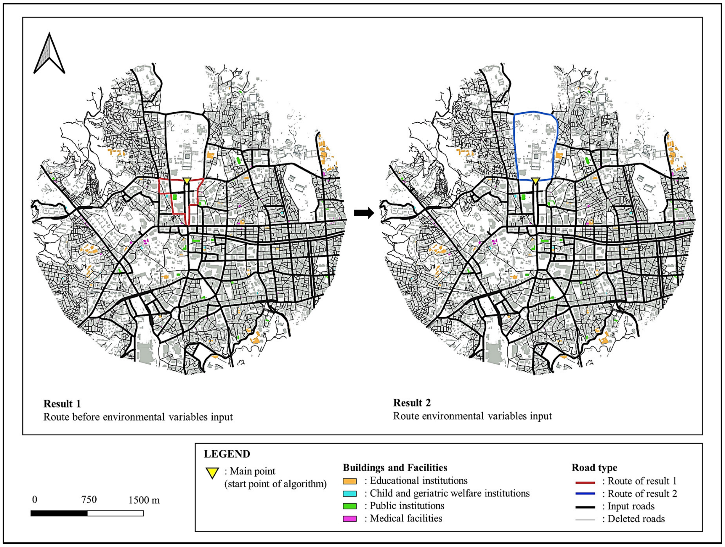
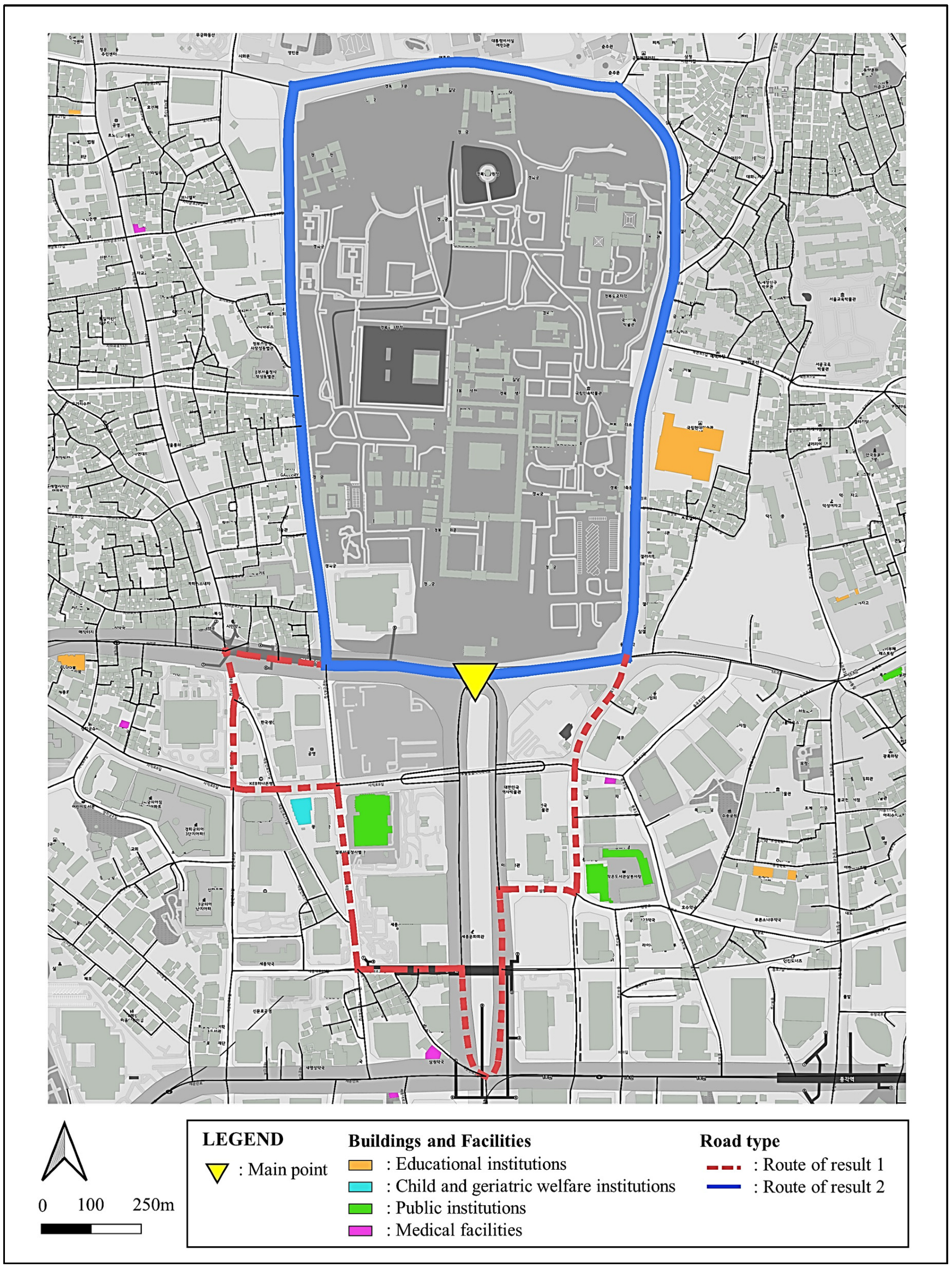
| Category | Parameter | Value | Result 1 | Result 2 |
|---|---|---|---|---|
| Level 01: Route variables—I | Width of the road (min.) | 12 M | 12.76 M | 14.14 M |
| Pass through intersections | Y | Y | Y | |
| Pass through bridges | N | N | N | |
| Pass through tunnel | N | N | N | |
| Height obstacle (min.) | 4.5 | None | None | |
| Level 02: Route variables—II | Track length | 2.4 KM | 2.59 KM | 2.70 KM |
| Tolerance range of track length | ±0.3 KM | +0.19 KM | +0.3 KM | |
| Number of turns (min.) | 14 turns | 14 | 11 | |
| Number of turns (max.) | 22 turns | |||
| Radius of turning (max.) | 12 M | 12 M | 12 M | |
| Buffer interval length (min.) | 120 M | 120 M | 120 M | |
| Level 03: Environmental variables | Educational-institution avoidance | Y | Y | N (1 time) |
| Child- and geriatric-welfare-institution avoidance | Y | Y | Y | |
| Public-institution avoidance | Y | N (3 time) | Y | |
| Medical-facility avoidance | Y | Y | Y | |
| Transportation-facility avoidance | Y | Y | Y |
Disclaimer/Publisher’s Note: The statements, opinions and data contained in all publications are solely those of the individual author(s) and contributor(s) and not of MDPI and/or the editor(s). MDPI and/or the editor(s) disclaim responsibility for any injury to people or property resulting from any ideas, methods, instructions or products referred to in the content. |
© 2023 by the authors. Licensee MDPI, Basel, Switzerland. This article is an open access article distributed under the terms and conditions of the Creative Commons Attribution (CC BY) license (https://creativecommons.org/licenses/by/4.0/).
Share and Cite
Yoon, Y.-J.; Kim, S.-Y.; Lee, Y.-K.; Ham, N.; Kim, J.-H.; Kim, J.-J. GIS-Based Multi-Objective Routing Approach for Street-Based Sporting-Event Routing. Appl. Sci. 2023, 13, 8453. https://doi.org/10.3390/app13148453
Yoon Y-J, Kim S-Y, Lee Y-K, Ham N, Kim J-H, Kim J-J. GIS-Based Multi-Objective Routing Approach for Street-Based Sporting-Event Routing. Applied Sciences. 2023; 13(14):8453. https://doi.org/10.3390/app13148453
Chicago/Turabian StyleYoon, Young-Joon, Seo-Yeon Kim, Yun-Ku Lee, Namhyuk Ham, Ju-Hyung Kim, and Jae-Jun Kim. 2023. "GIS-Based Multi-Objective Routing Approach for Street-Based Sporting-Event Routing" Applied Sciences 13, no. 14: 8453. https://doi.org/10.3390/app13148453
APA StyleYoon, Y.-J., Kim, S.-Y., Lee, Y.-K., Ham, N., Kim, J.-H., & Kim, J.-J. (2023). GIS-Based Multi-Objective Routing Approach for Street-Based Sporting-Event Routing. Applied Sciences, 13(14), 8453. https://doi.org/10.3390/app13148453


