
Usage of V2X Applications in Road Tunnels


Abstract
:Featured Application
Abstract
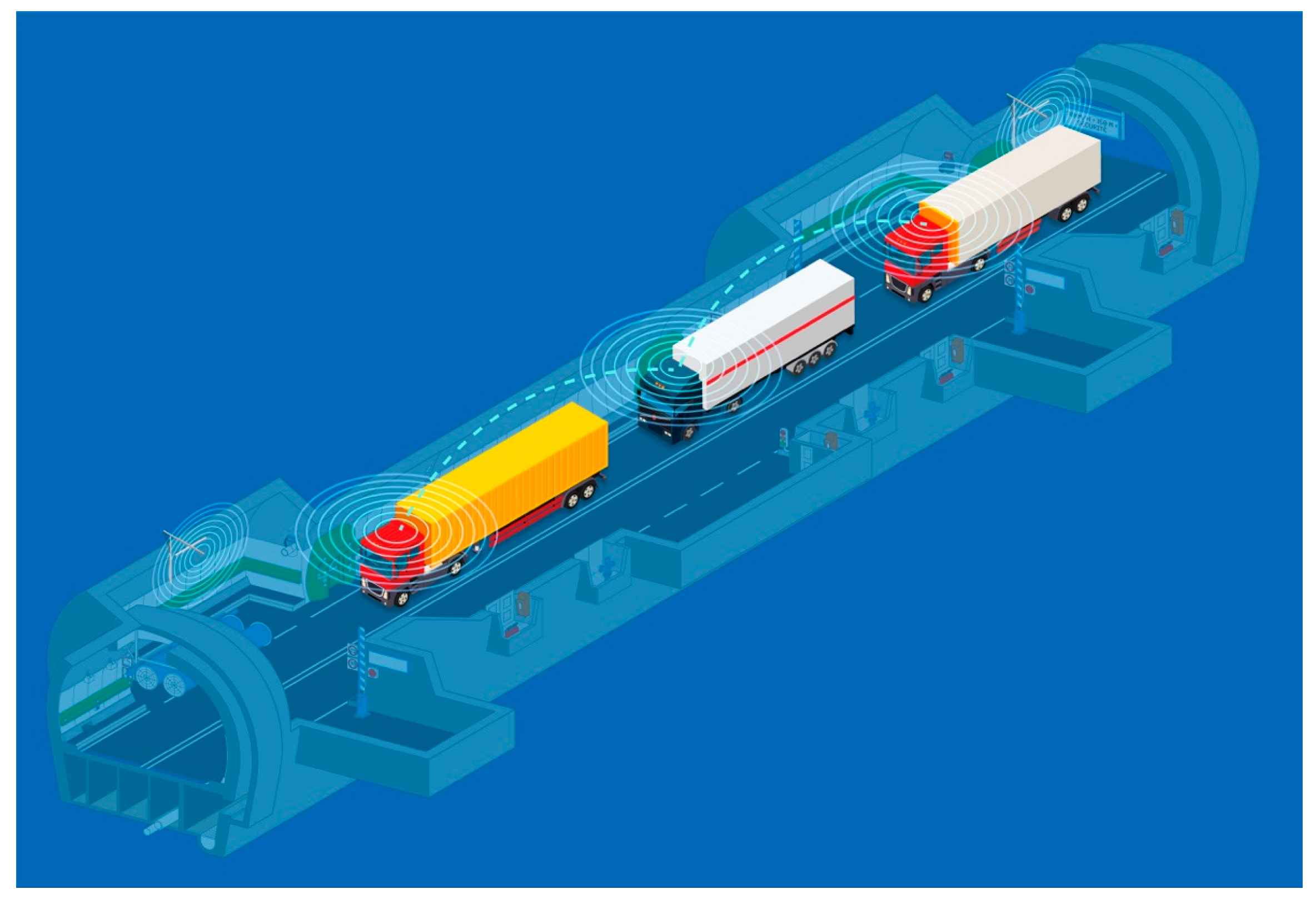
1. Introduction
2. Background
2.1. Positioning Approaches
2.2. V2X Requirements
3. Methodology
3.1. Test Conditions
3.2. Testing Scenarios
3.2.1. Pre-Test
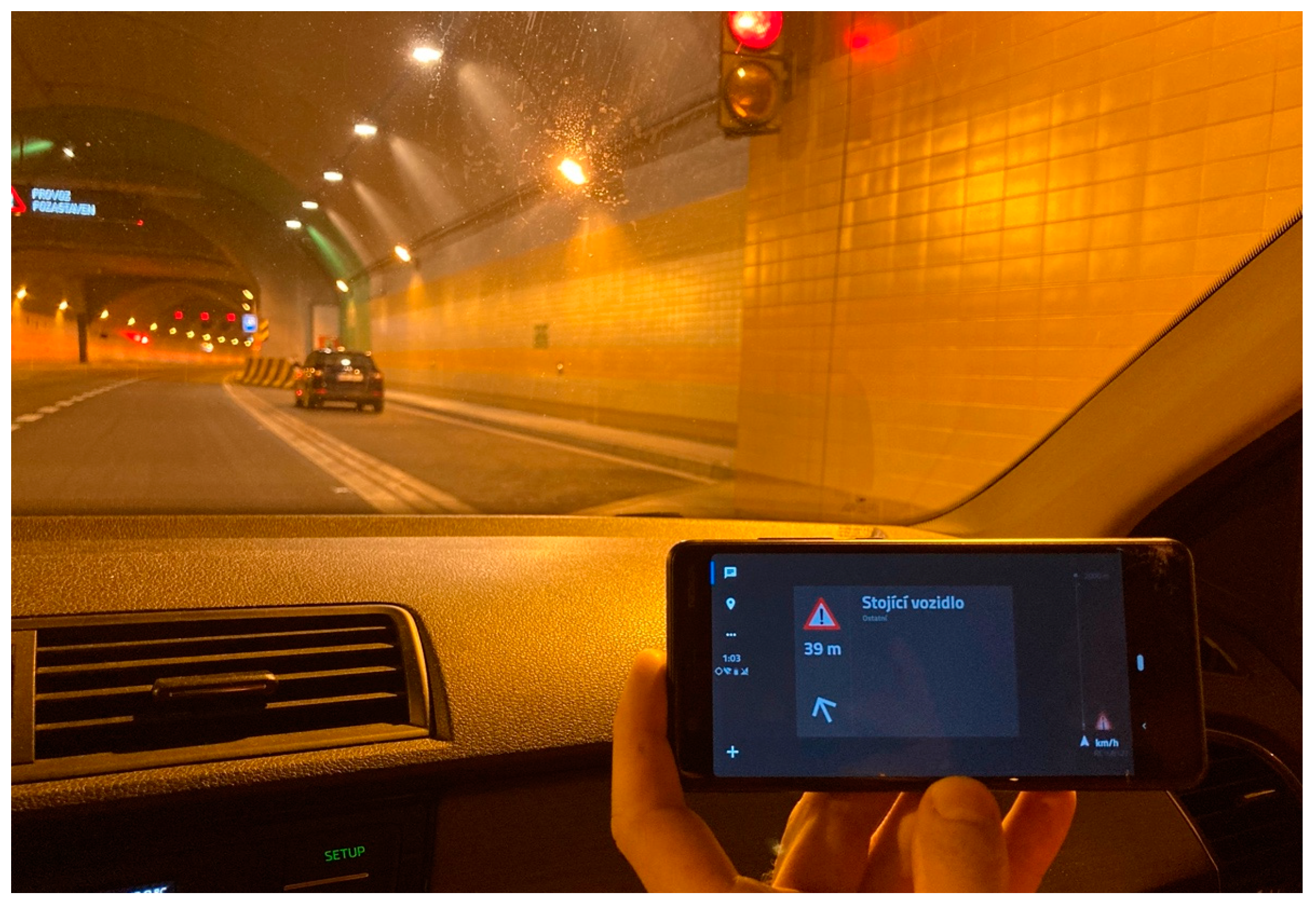
3.2.2. Test of V2X Communication
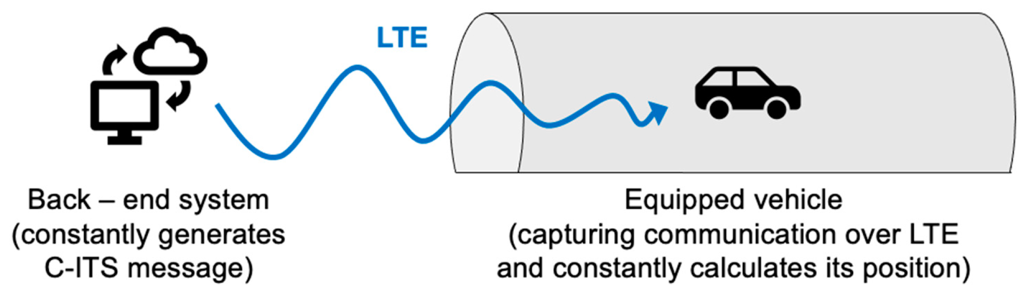
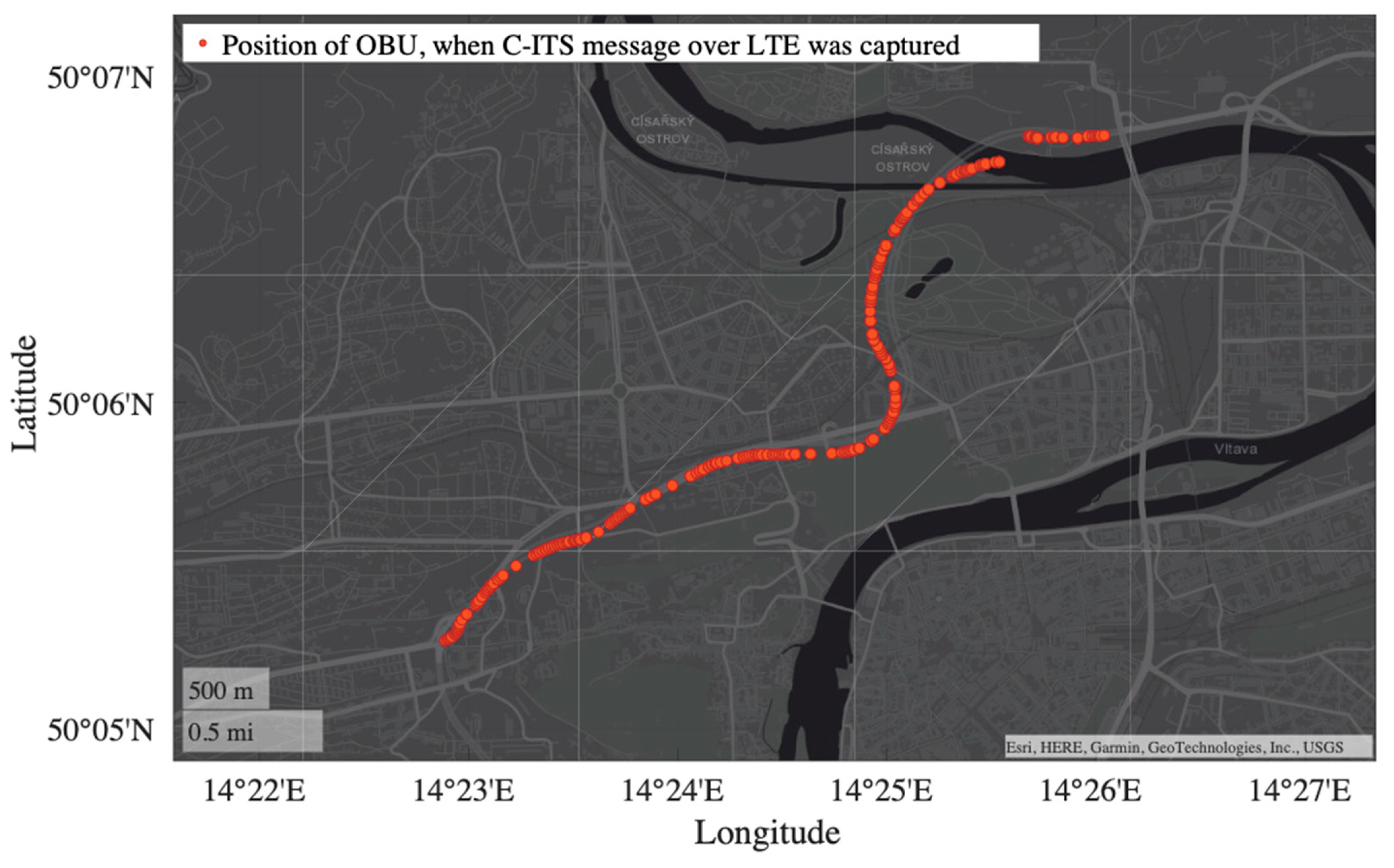
3.3. Methodology of the Data Acquisition and Evaluation Procedure
4. Results
5. Discussion
- Travel time in the monitored section
- Average speed (section speed)
- Travel time delay in the monitored section
- Detection of a traffic jam in the monitored section
- Detection of a braking/stopped vehicle and direction of vehicle movement
- Vehicle acceleration/deceleration
- Use of vehicle control units
- Number of people in the vehicle (for evacuation modeling)
- In-vehicle infrastructure information (speed limits, delay information)
- Approaching emergency vehicle position in the tunnel
- Position of accident, stationary vehicle, or cargo
- Information about hazardous event/position in tunnels, evacuation information, etc.
- Information for drivers in convoys, information about approaching IRS vehicles
- Vehicle maintenance position to prevent potential collisions and emergency lane closures
6. Future Work
Author Contributions
Funding
Institutional Review Board Statement
Informed Consent Statement
Data Availability Statement
Acknowledgments
Conflicts of Interest
References
- D’Aniello, G.; Gaeta, M.; Orciuoli, F.; Sansonetti, G.; Sorgente, F. Knowledge-Based Smart City Service System. Electronics 2020, 9, 965. [Google Scholar] [CrossRef]
- Negre, E.; Rosenthal-Sabroux, C.; Gascó, M. A Knowledge-Based Conceptual Vision of the Smart City. In Proceedings of the 48th Hawaii International Conference on System Sciences, Kauai, HI, USA, 5–8 January 2015; pp. 2317–2325. [Google Scholar] [CrossRef]
- Silva, B.N.; Khan, M.; Seo, J.; Muhammad, D.; Yoon, Y.; Han, J.; Han, K. Exploiting big data analytics for urban planning and smart city performance improvement. In Proceedings of the 2018 12th International Conference on Signal Processing and Communication Systems (ICSPCS), Cairns, QLD, Australia, 17–19 December 2018. [Google Scholar]
- Sofeska, E. Understanding the livability in a city through smart solutions and urban planning toward developing sustainable livable future of the city of Skopje. Procedia Environ. Sci. 2017, 37, 442–453. [Google Scholar] [CrossRef]
- Mautz, R. The challenges of indoor environments and specification on some alternative positioning systems. In Proceedings of the 2009 6th Workshop on Positioning, Navigation and Communication, Hannover, Germany, 19 March 2009; pp. 29–36. [Google Scholar] [CrossRef]
- Canto-Perello, J.; Curiel-Esparza, J. An analysis of utility tunnel viability in urban areas. Civ. Eng. Environ. Syst. 2006, 23, 11–19. [Google Scholar] [CrossRef]
- Přibyl, O.; Přibyl, P.; Svítek, M. Interdisciplinary Urban Tunnel Control within Smart Cities. Appl. Sci. 2021, 11, 10950. [Google Scholar] [CrossRef]
- Huang, L.; Bohne, R.A.; Bruland, A. Life cycle assessment of Norwegian road tunnel. Int. J. Life Cycle Assess 2015, 20, 174–184. [Google Scholar] [CrossRef]
- Tichý, T.; Brož, J.; Bělinová, Z.; Pirník, R. Analysis of Predictive Maintenance for Tunnel Systems. Sustainability 2021, 13, 3977. [Google Scholar] [CrossRef]
- Tichý, T.; Brož, J.; Bělinová, Z.; Kouba, P. Predictive diagnostics usage for telematic systems maintenance. In Proceedings of the 2020 Smart City Symposium Prague (SCSP), Prague, Czech Republic, 25 June 2020; pp. 1–6. [Google Scholar] [CrossRef]
- Alam, N.; Kealy, A.; Dempster, A.G. Cooperative Inertial Navigation for GNSS-Challenged Vehicular Environments. IEEE Trans. Intell. Transp. Syst. 2013, 14, 1370–1379. [Google Scholar] [CrossRef]
- Sun, Z.; Tang, K.; Wang, X.; Wu, M.; Guo, Y. High-Speed Train Tunnel Navigation Method Based on Integrated MIMU/ODO/MC Navigation. Appl. Sci. 2021, 11, 3680. [Google Scholar] [CrossRef]
- Werner, M. Indoor Location-Based Services: Prerequisites and Foundations; Springer: Berlin/Heidelberg, Germany, 2014. [Google Scholar]
- Jeong, S.; Baek, Y.; Son, S.H. A Hybrid V2X System for Safety-Critical Applications in VANET. In Proceedings of the 2016 IEEE 4th International Conference on Cyber-Physical Systems, Networks, and Applications (CPSNA), Nagoya, Japan, 6–7 October 2016; pp. 13–18. [Google Scholar] [CrossRef]
- Wang, J.; Shao, Y.; Ge, Y.; Yu, R. A Survey of Vehicle to Everything (V2X) Testing. Sensors 2019, 19, 334. [Google Scholar] [CrossRef] [Green Version]
- Malik, R.Q.; Zaidan, A.A.; Zaidan, B.B.; Ramli, K.N.; Albahri, O.S.; Kareem, Z.H.; Ameen, H.A.; Garfan, S.S.; Mohammed, A.; Zaidan, R.A.; et al. Novel roadside unit positioning framework in the context of the vehicle-to-infrastructure communication system based on AHP—Entropy for weighting and borda—VIKOR for uniform ranking. Int. J. Inf. Technol. Decis. Mak. 2021. [Google Scholar] [CrossRef]
- Fouda, A.; Keating, R.; Ghosh, A. Dynamic Selective Positioning for High-Precision Accuracy in 5G NR V2X Networks. In Proceedings of the 2021 IEEE 93rd Vehicular Technology Conference (VTC2021-Spring), Helsinki, Finland, 25–28 April 2021; pp. 1–6. [Google Scholar] [CrossRef]
- Wang, Z. Research on Key Technologies of Traffic Guidance in Smart City under the Environment of Internet of Vehicles. In Proceedings of the 2019 International Conference on Electronic Engineering and Informatics (EEI), Nanjing, China, 8–10 November 2019; pp. 94–100. [Google Scholar] [CrossRef]
- Hashmi, M.T.; Adnan, A.; Hadi, F.; Zubair, M. Localized data fusion model for VANETs using GPS and non-GPS system. In Proceedings of the 2017 International Conference on Communication Technologies (ComTech), Rawalpindi, Pakistan, 19–21 April 2017; pp. 180–185. [Google Scholar] [CrossRef]
- Schmitt, T.; Hanek, R.; Beetz, M.; Buck, S.; Radig, B. Cooperative probabilistic state estimation for vision-based autonomous mobile robots. IEEE Trans. Robot. Autom. 2002, 18, 670–684. [Google Scholar] [CrossRef]
- Pastor, C.; Ruiz-Gonzalez, R.; Gomez-Gil, J. A data fusion system of GNSS data and on-vehicle sensors data for improving car positioning precision in urban environments. Expert Syst. Appl. 2017, 80, 28–38. [Google Scholar] [CrossRef]
- Zheng, L.; Zhou, W.; Tang, W.; Zheng, X.; Peng, A.; Zheng, H. A 3D indoor positioning system based on low-cost MEMS sensors. Simul. Model. Pract. Theory 2016, 65, 45–56. [Google Scholar] [CrossRef]
- Zhang, Q.; Guan, L.; Xu, D. Odometer Velocity and Acceleration Estimation Based on Tracking Differentiator Filter for 3D-Reduced Inertial Sensor System. Sensors 2019, 19, 4501. [Google Scholar] [CrossRef] [Green Version]
- Nemec, D.; Hrubos, M.; Janota, A.; Pirnik, R.; Gregor, M. Estimation of the Speed From the Odometer Readings Using Optimized Curve-Fitting Filter. IEEE Sens. J. 2021, 21, 15687–15695. [Google Scholar] [CrossRef]
- Subedi, S.; Kwon, G.-R.; Shin, S.; Hwang, S.-S.; Pyun, J.Y. Beacon based indoor positioning system using weighted centroid localization approach. In Proceedings of the 2016 Eighth International Conference on Ubiquitous and Future Networks (ICUFN), Vienna, Austria, 5–8 July 2016; pp. 1016–1019. [Google Scholar] [CrossRef]
- Bisio, I.; Cerruti, M.; Lavagetto, F.; Marchese, M.; Pastorino, M.; Randazzo, A.; Sciarrone, A. A Trainingless WiFi Fingerprint Positioning Approach Over Mobile Devices. IEEE Antennas Wirel. Propag. Lett. 2014, 13, 832–835. [Google Scholar] [CrossRef]
- Balchen, J.G.; Jenssen, N.A.; Mathisen, E.; Sælid, S. A Dynamic Positioning System Based on Kalman Filtering and Optimal Control; Norwegian Society of Automatic Control, Modelling, Identification and Control: Prague, Czech Republic; pp. 135–163. [CrossRef]
- Steinhoff, U.; Schiele, B. Dead reckoning from the pocket—An experimental study. In Proceedings of the 2010 IEEE International Conference on Pervasive Computing and Communications (PerCom), Mannheim, Germany, 29 March–2 April 2010; pp. 162–170. [Google Scholar] [CrossRef]
- Quddus, M.; Ochieng, W.; Noland, R. Current map-matching algorithms for transport applications: State-of-the art and future research directions. Transp. Res. Part C Emerg. Technol. 2007, 15, 312–328. [Google Scholar] [CrossRef] [Green Version]
- Strange, A.; Ralston, J. Development of a real-time georeferenced subsurface radar system for mining applications. In Proceedings of the 2011 6th International Workshop on Advanced Ground Penetrating Radar (IWAGPR), Aachen, Germany, 22–24 June 2011. [Google Scholar] [CrossRef]
- ETSI: Intelligent Transport Systems (ITS); Facilities Layer Function; Part 2: Position and Time Management (PoTi); Release 2 ETSI EN 302 890-2 V2.1.1 (2020-10). Available online: https://www.etsi.org/deliver/etsi_en/302800_302899/30289002/02.01.01_60/en_30289002v020101p.pdf (accessed on 2 March 2022).
- Chapman, M.; Min, C.; Zhang, D. Continuous mapping of tunnel walls in a gnss-denied environment. ISPRS-Int. Arch. Photogramm. Remote Sens. Spat. Inf. Sci. 2016, XLI-B3, 481–485. [Google Scholar] [CrossRef] [Green Version]
- ATMB. The Mont Blanc Autoroute and Tunnel. Available online: https://www.atmb.com/sites/default/files/edito/platooning_tunnel_mont_blanc_atmb.jpg (accessed on 28 June 2021).
- Lokaj, Z.; Srotyr, M.; Vanis, M.; Broz, J. Technical part of evaluation solution for cooperative vehicles within C-ROADS CZ project. In Proceedings of the 2020 Smart City Symposium Prague (SCSP), Prague, Czech Republic, 25 June 2020; pp. 1–5. [Google Scholar] [CrossRef]
- Röglinger, S. A methodology for testing intersection related Vehicle-2-X applications. Comput. Netw. 2011, 55, 3154–3168. [Google Scholar] [CrossRef]
- Jerabek, M.; Broz, J. Use Cases for C-ITS Testing of Autonomous Vehicles. In 5th EAI International Conference on Management of Manufacturing Systems; Springer Innovations in Communication and Computing; Springer: Cham, Switzerland, 2022; pp. 219–227. [Google Scholar] [CrossRef]
- Hejazi, H.; Bokor, L. A Survey on the Use-Cases and Deployment Efforts Toward Converged Internet of Things (IoT) and Vehicle-to-Everything (V2X) Environments. Acta Technol. Jaurinensis 2021. [Google Scholar] [CrossRef]
- Lokaj, Z.; Srotyr, M.; Vanis, M.; Broz, J.; Mlada, M. C-ITS SIM as a tool for V2X communication and its validity assessment. In Proceedings of the 2021 Smart City Symposium Prague (SCSP), Prague, Czech Republic, 27–28 May 2021; pp. 1–5. [Google Scholar] [CrossRef]
- Fouchal, H.; Bourdy, E.; Wilhelm, G.; Ayaida, M. A validation tool for cooperative intelligent transport systems. J. Comput. Sci. 2017, 22, 283–288. [Google Scholar] [CrossRef]
- Broz, J.; Srotyr, M.; Jerabek, M. Use Cases and C-ITS Communication Analysis as a Step Towards the Connected Mobility. In Sustainable Management of Manufacturing Systems in Industry 4.0; EAI/Springer Innovations in Communication and Computing; Springer: Cham, Switzerland, 2022. [Google Scholar] [CrossRef]
- Pokorny, J.; Seda, P.; Dvorak, J.; Malina, L.; Martinasek, Z. The Security Testbed for the Purposes of the ITS-G5 Communication Attacks Prevention. In Proceedings of the 2021 13th International Congress on Ultra Modern Telecommunications and Control Systems and Workshops (ICUMT), Brno, Czech Republic, 25–27 October 2021; pp. 167–173. [Google Scholar] [CrossRef]
- O2 Czech Republic, a.s., Press Center. O2 v Praze Spustilo 3CC Díky Spojení tří Frekvencí Dosáhne Rychlostí Okolo 250 Mbit/s. 10 March 2016. Available online: https://www.o2.cz/spolecnost/tiskove-centrum/463979-O2_v_Praze_spustilo_3CC_Diky_spojeni_tri_frekvenci_dosahne_rychlosti_okolo_250_Mbit_s.html (accessed on 8 March 2022).
- Standard, ETSI DSRC. No. EN 302 637-3, Intelligent Transport Systems (ITS); Vehicular Communications; Basic Set of Applications; Part 3: Specifications of Decentralized Environmental Notification Basic Service. 2019. Available online: http://www.etsi.org/deliver/etsi_en/302600_302699/30263703/01.03.01_60/en_30263703v010301p.pdf (accessed on 15 April 2022).
- Gavulova, A.; Pirnik, R.; Hudec, R. Technical Support of Traffic Control System of Slovak Agglomerations in NaTIS Project. In Proceedings of the 11th International Conference on Transport Systems Telematics (TST 2011) Modern Transport Telematics 239, Katowice-Ustron, Poland, 19–22 October 2011; p. 382. [Google Scholar]
- Kuda, F.; Dlask, P.; Teichmann, M.; Beran, V. Time–Cost Schedules and Project–Threats Indication. Sustainability 2022, 14, 2828. [Google Scholar] [CrossRef]
- Thomas, K.; Fouchal, H.; Cormier, S.; Rousseaux, F. C-ITS Communications based on BLE Messages. In Proceedings of the GLOBECOM 2020—2020 IEEE Global Communications Conference, Taipei, Taiwan, 7–11 December 2020; pp. 1–7. [Google Scholar] [CrossRef]
- Ji, M.; Kim, J.; Jeon, J.; Cho, Y. Analysis of positioning accuracy corresponding to the number of BLE beacons in indoor positioning system. In Proceedings of the 2015 17th International Conference on Advanced Communication Technology (ICACT), PyeongChang, Korea, 1–3 July 2015. [Google Scholar]
- Davi, L.; Hatebur, D.; Heisel, M.; Wirtz, R. Combining safety and security in autonomous cars using blockchain technologies. In International Conference on Computer Safety, Reliability, and Security; Springer: Cham, Switzerland, 2019. [Google Scholar]
- Kamal, M.; Tariq, M.; Srivastava, G.; Malina, L. Optimized Security Algorithms for Intelligent and Autonomous Vehicular Transportation Systems. IEEE Trans. Intell. Transp. Syst. 2021. [Google Scholar] [CrossRef]
- Chen, C.-M.; Xiang, B.; Liu, Y.; Wang, K.-H. A secure authentication protocol for internet of vehicles. IEEE Access 2019, 7, 12047–12057. [Google Scholar] [CrossRef]


Publisher’s Note: MDPI stays neutral with regard to jurisdictional claims in published maps and institutional affiliations. |
© 2022 by the authors. Licensee MDPI, Basel, Switzerland. This article is an open access article distributed under the terms and conditions of the Creative Commons Attribution (CC BY) license (https://creativecommons.org/licenses/by/4.0/).
Share and Cite
Brož, J.; Tichý, T.; Angelakis, V.; Bělinová, Z. Usage of V2X Applications in Road Tunnels. Appl. Sci. 2022, 12, 4624. https://doi.org/10.3390/app12094624
Brož J, Tichý T, Angelakis V, Bělinová Z. Usage of V2X Applications in Road Tunnels. Applied Sciences. 2022; 12(9):4624. https://doi.org/10.3390/app12094624
Chicago/Turabian StyleBrož, Jiří, Tomáš Tichý, Vangelis Angelakis, and Zuzana Bělinová. 2022. "Usage of V2X Applications in Road Tunnels" Applied Sciences 12, no. 9: 4624. https://doi.org/10.3390/app12094624
APA StyleBrož, J., Tichý, T., Angelakis, V., & Bělinová, Z. (2022). Usage of V2X Applications in Road Tunnels. Applied Sciences, 12(9), 4624. https://doi.org/10.3390/app12094624