
Temporal and Spatial Geophysical Data Analysis in the Issues of Natural Hazards and Risk Assessment (in Example of North Ossetia, Russia)


Abstract
1. Introduction
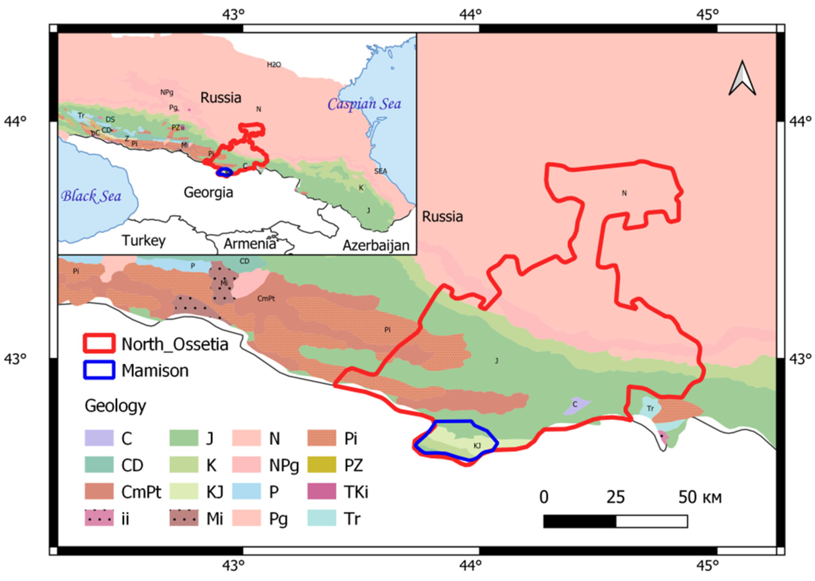
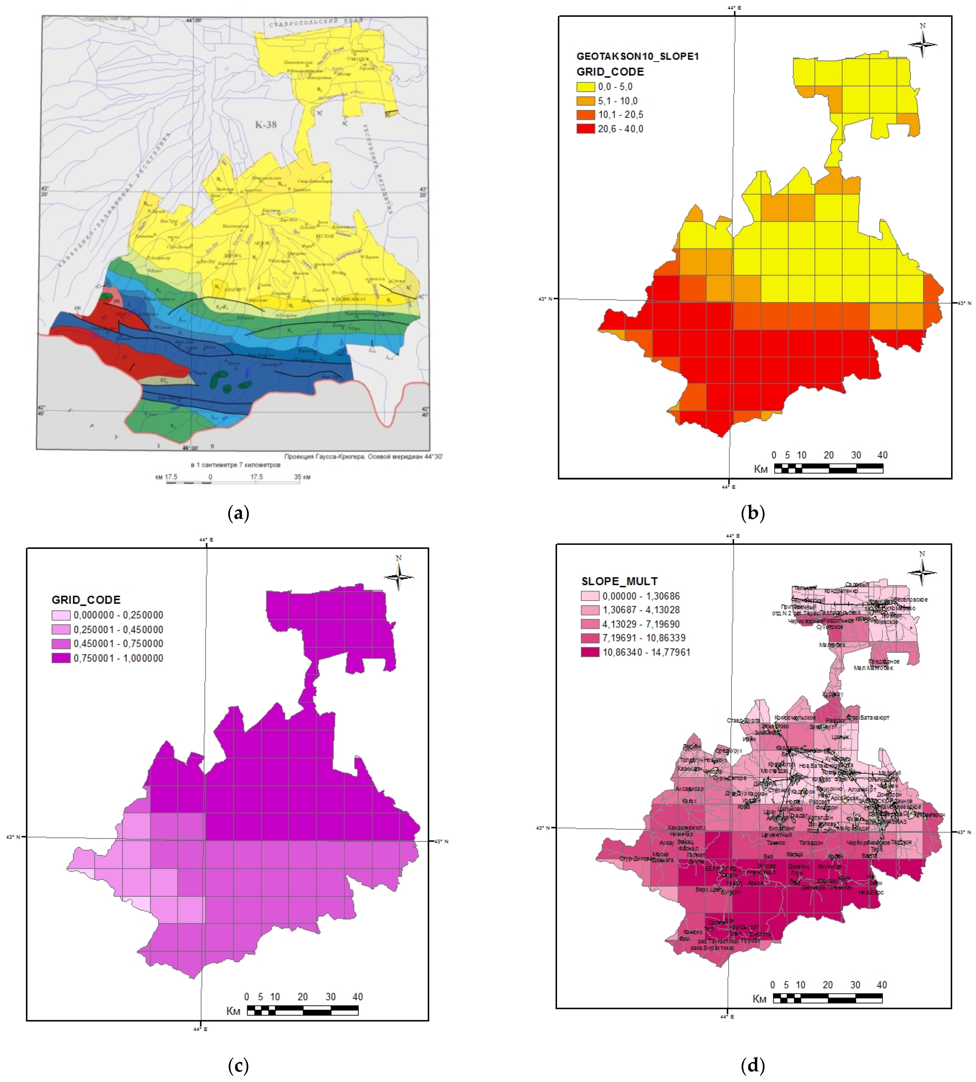
2. Geographical and Geological Setting
3. Materials and Methods
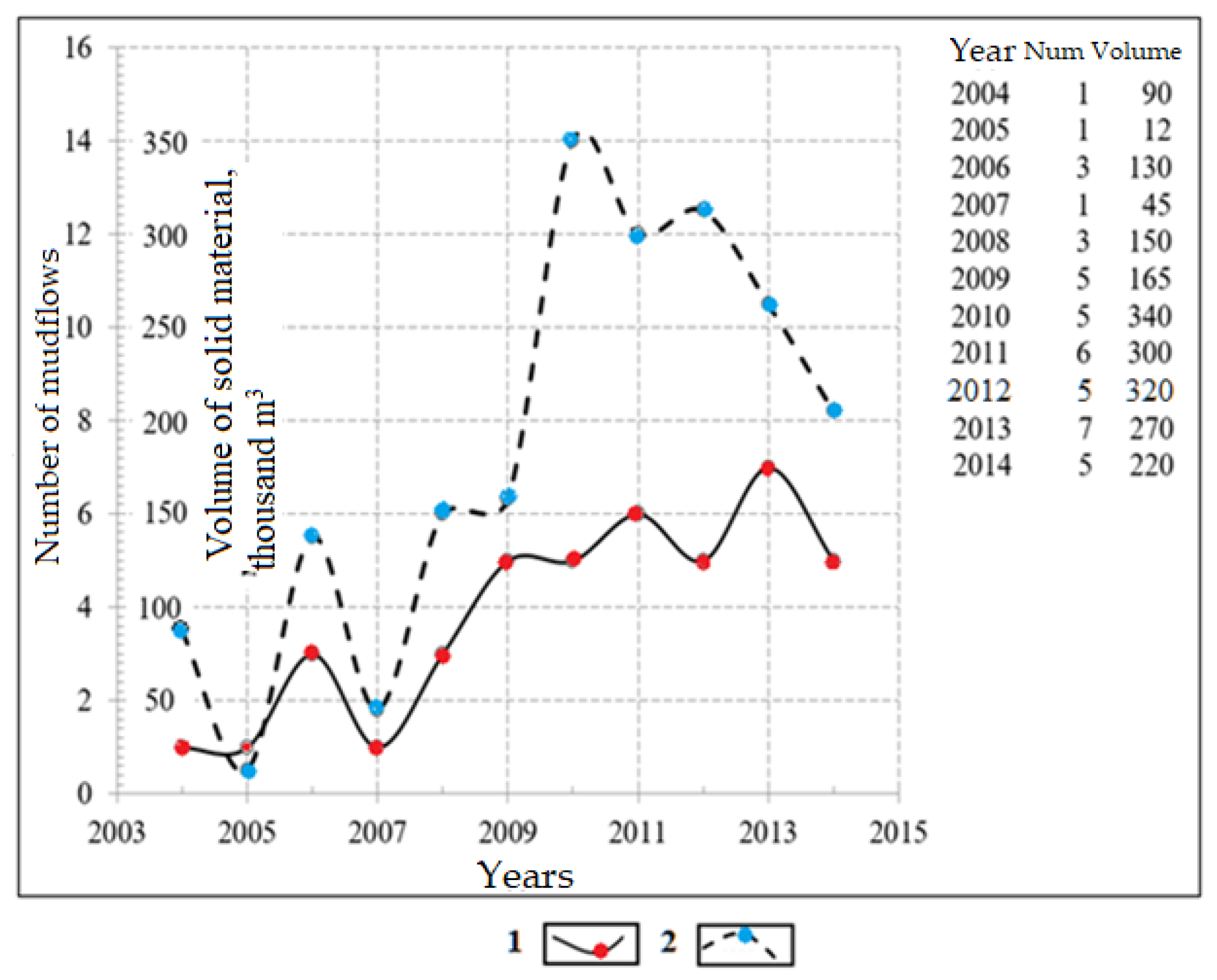
3.1. Mudflows
3.2. Avalanches
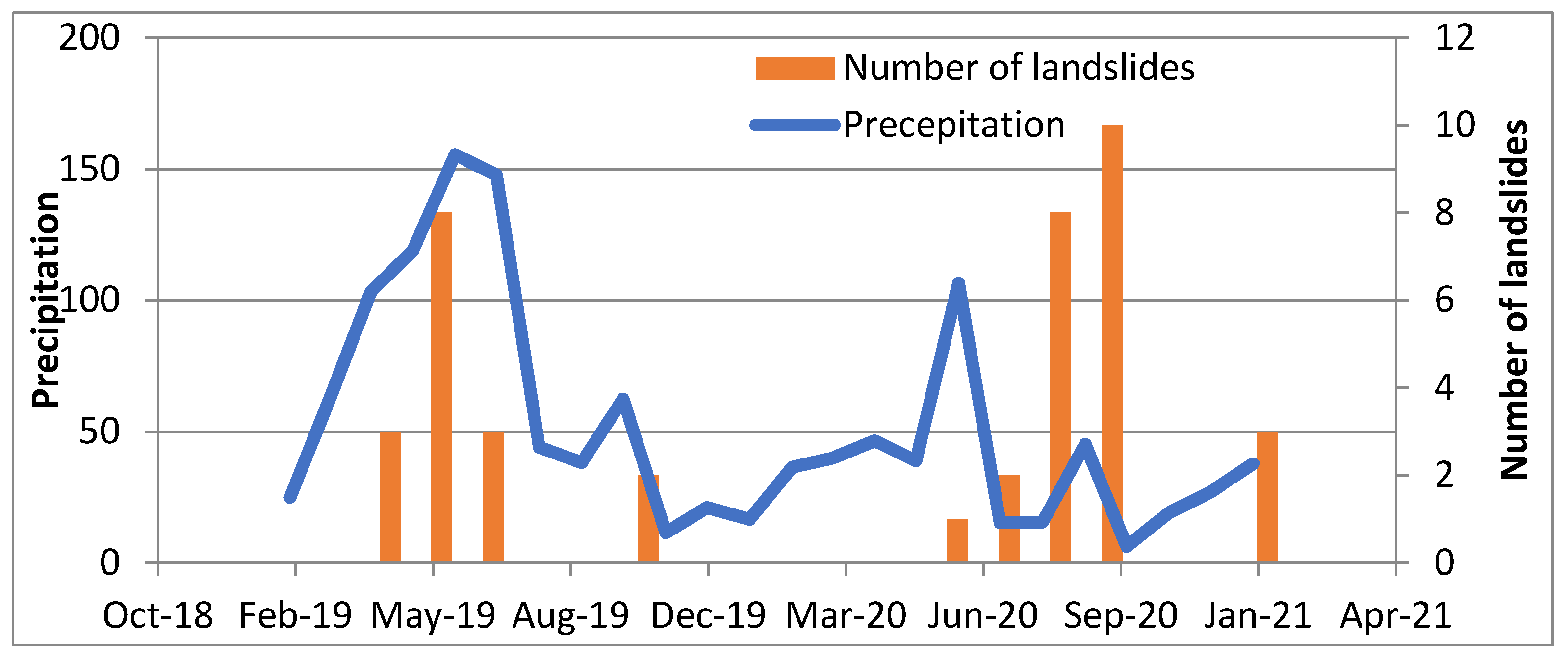
3.3. Landslides
3.4. Earthquakes
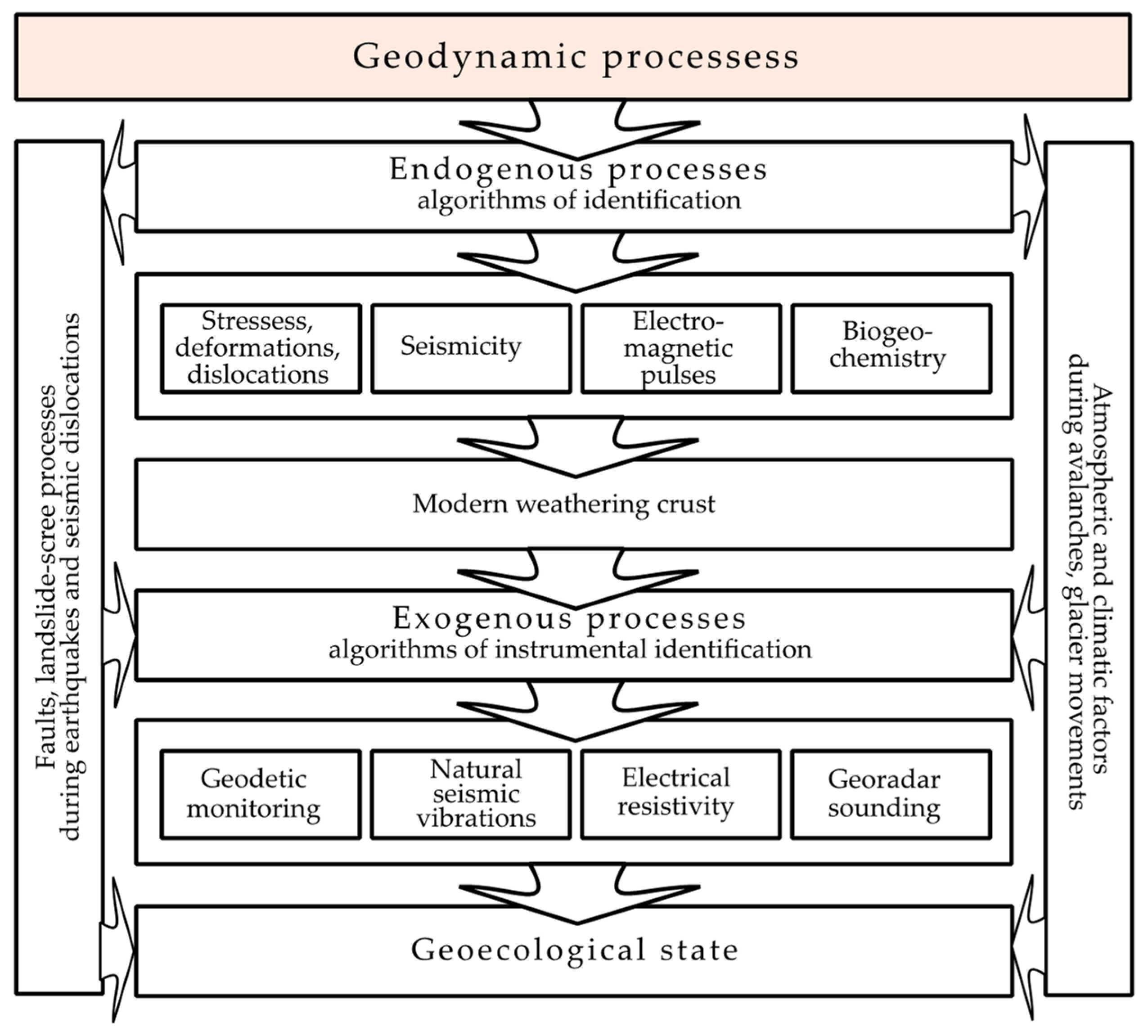
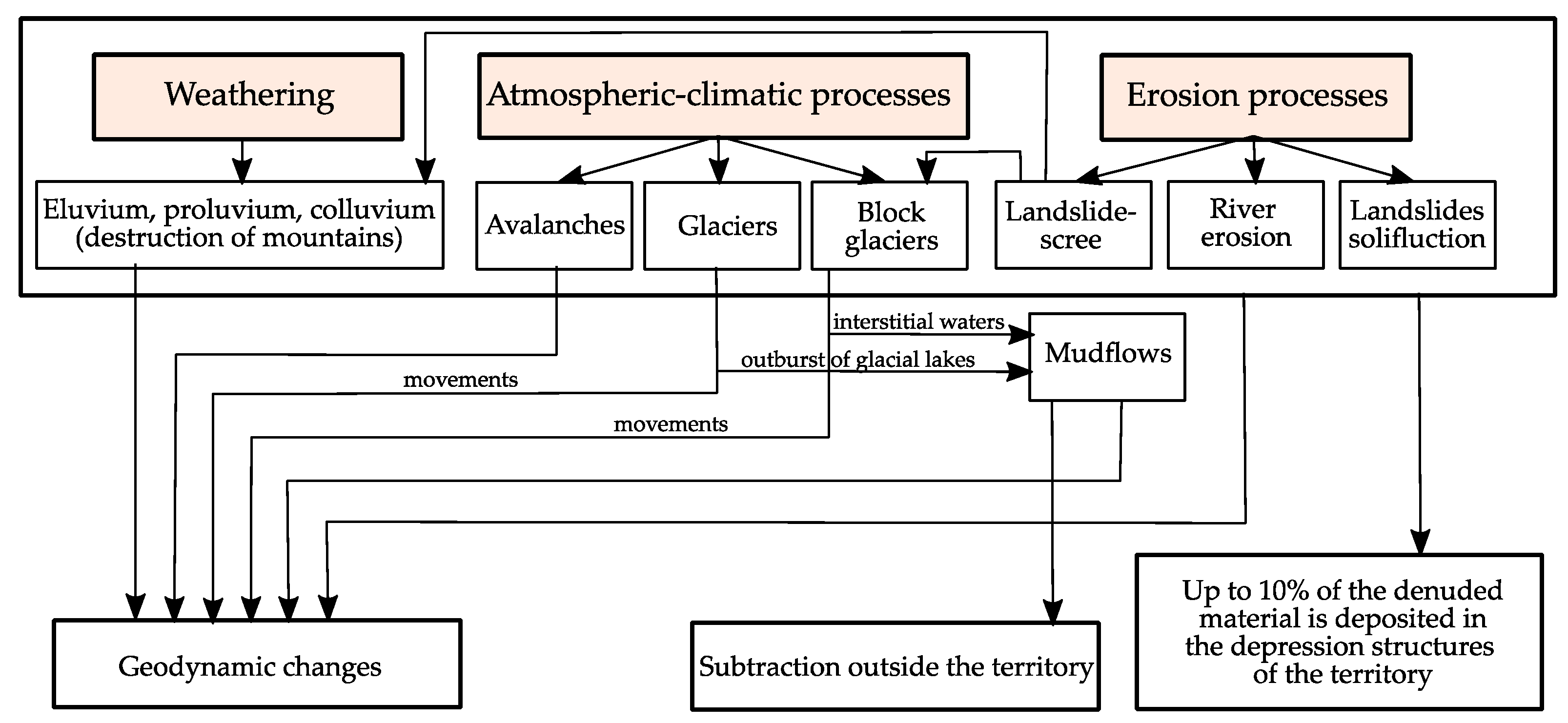
4. Results
- (1)
- The zone of minimal impact is the flat northeastern part, built up with cities and industrial facilities. Beslan can be considered as the center of this zone because it is the optimal area for the development of the republic. The largest settlement on the territory of North Ossetia-Alania, Vladikavkaz, to a greater extent, is potentially exposed to natural impacts;
- (2)
- The mountain part with the presence of historical settlements and objects associated with mining. This part is prone to the highest level of natural impact. The zone of the “Mamison” complex is also located in the zone of high impact.
5. Discussion
6. Conclusions
Author Contributions
Funding
Institutional Review Board Statement
Informed Consent Statement
Data Availability Statement
Conflicts of Interest
References
- Ahmed, A.; Nawaz, R.; Woulds, C.; Drake, F. Influence of hydro-climatic factors on future coastal land susceptibility to erosion in Bangladesh: A geospatial modelling approach. J. Geovisualization Spat. Anal. 2020, 4, 6. [Google Scholar] [CrossRef]
- Hird, R.; Di Matteo, N.; Gulerce, U.; Babu, V.L.S.; Rafiq, A. Geohazards of Saudi Arabia. J. Maps 2019, 15, 626–634. [Google Scholar] [CrossRef]
- Griffiths, J.S. Engineering Geological Mapping; Geological Society; Engineering Geology Special Publications: London, UK, 2001; Volume 18, pp. 39–42. [Google Scholar] [CrossRef]
- Mason, P.J.; Rosenbaum, M.S. Geohazard mapping for predicting landslides: An example from the Langhe Hills in Piemonte, NW Italy. Q. J. Eng. Geol. Hydrogeol. 2002, 35, 317–326. [Google Scholar] [CrossRef]
- Ali, S.; Biermanns, P.; Haider, R.; Reicherter, K. Landslide susceptibility mapping by using a geographic information system (GIS) along the China–Pakistan Economic Corridor (Karakoram Highway), Pakistan. Nat. Hazards Earth Syst. Sci. 2019, 19, 999–1022. [Google Scholar] [CrossRef]
- Kern, K.; Lieb, G.K.; Seier, G.; Kellerer-Pirklbauer, A. Modelling geomorphological hazards to assess the vulnerability of alpine infrastructure: The example of the grossglockner-pasterze area, Austria. Austrian J. Earth Sci. 2012, 105, 113–127. [Google Scholar]
- Ayele, S.; Raghuvanshi, T.K.; Kala, P.M. Application of Remote Sensing and GIS for Landslide Disaster Management: A Case from Abay Gorge, Gohatsion–Dejen Section, Ethiopia. In Landscape Ecology and Water Management; Springer: Tokyo, Japan, 2014; pp. 15–32. [Google Scholar] [CrossRef]
- Chandak, P.G.; Sayyed, S.S.; Kulkarni, Y.U.; Devtale, M.K. Application of geoinformatics for landslide susceptibility analysis in Konkan region, Maharashtra. J. NX—Multidiscip. Peer Rev. J. 2021, 3, 25–29. [Google Scholar]
- Kumar, N.S.; Ismail, M.A.M.; Sukor, N.S.A.; Cheang, W. Geohazard reconnaissance mapping for potential rock boulder fall using low altitude UAV photogrammetry. IOP Conf. Ser. Mater. Sci. Eng. 2017, 352, 012033. [Google Scholar] [CrossRef]
- Persits, F.M.; Ulmishek, G.F.; Steinshouer, D.W. Maps Showing Geology, Oil and Gas Fields and Geologic Provinces of the Former Soviet Union; Open-File Report 97-470E; U.S. Department of the Interior: Washington, DC, USA, 1997. [CrossRef]
- Annual State Report; Ministry of Emergency Situations of the Republic of North Ossetia-Alania: Vladikavkaz, Russia, 2000; p. 118. (In Russian)
- Zaalishvili, V.B.; Chotchaev, K.O. Classification of natural electromagnetic fields. Researches by the method of telluric currents. Geol. Geophys. Russ. South 2016, 2, 27–35. (In Russian) [Google Scholar] [CrossRef]
- Intarawichian, N.; Dasananda, S. Analytical hierarchy process for landslide susceptibility mapping in lower Mae Chaem watershed, Northern Thailand, Suranaree. J. Sci. Technol. 2010, 17, 277–292. [Google Scholar]
- Basharat, M.; Shah, H.R.; Hameed, N. Landslide susceptibility mapping using GIS and weighted overlay method: A case study from NW Himalayas, Pakistan. Arab. J. Geosci. 2016, 9, 292. [Google Scholar] [CrossRef]
- Roslee, R.; Mickey, A.C.; Simon, N.; Norhisham, M.N. Landslide susceptibility analysis lsa using weighted overlay method wom along the gentingsempah to bentong highway pahang. Malays. J. Geosci. 2017, 1, 13–19. [Google Scholar] [CrossRef]
- Shit, P.K.; Bhunia, G.S.; Maiti, R. Potential landslide susceptibility mapping using weighted overlay model (WOM). Model. Earth Syst. Environ. 2016, 2, 21. [Google Scholar] [CrossRef]
- Chotchaev, K.O.; Burdzieva, O.G.; Zaalishvili, V.B. Influence of geodynamic processes on the geoecological state of high mountain areas. Geol. Geophys. Russ. South 2020, 10, 70–100. (In Russian) [Google Scholar] [CrossRef]
- Stogny, V.V.; Stogny, G.A.; Lyubimova, T.V. Geoecological risks of the Krasnodar region: The problem of integrated assessment of the geological hazards degree. Geol. Geophys. Russ. South 2021, 11, 121–133. (In Russian) [Google Scholar] [CrossRef]
- Peethambaran, B.; Anbalagan, R.; Shihabudheen, K.V. Landslide susceptibility mapping in and around Mussoorie Township using fuzzy set procedure, MamL and improved fuzzy expert system-A comparative study. Nat. Hazards 2018, 96, 121–147. [Google Scholar] [CrossRef]
- Peethambaran, B.; Anbalagan, R.; Shihabudheen, K.V.; Goswami, A. Robustness evaluation of fuzzy expert system and extreme learning machine for geographic information system-based landslide susceptibility zonation: A case study from Indian Himalaya. Environ. Earth Sci. 2019, 78, 231. [Google Scholar] [CrossRef]
- Goltsman, F.M. Integration of observations in the recognition of geophysical objects. FizikaZemli 1976, 7, 40–54. (In Russian) [Google Scholar] [CrossRef]
- Goltsman, F.M. Information richness of the experiment and accounting for the correlation of non-numeric features in the recognition of geophysical objects. FizikaZemli 1980, 10, 71–85. [Google Scholar]
- Daniel, M.T.; Ng, T.F.; Kadir, M.F.A.; Pereira, J.J. Landslide Susceptibility Modeling Using a Hybrid Bivariate Statistical and Expert Consultation Approach in Canada Hill, Sarawak, Malaysia. Front. Earth Sci. 2021, 9, 616225. [Google Scholar] [CrossRef]
- García, C.L.; Teich, I.; Gonzalez-Roglich, M.; Kindgard, A.F.; Ravelo, A.C.; Liniger, H. Land degradation assessment in the Argentinean Puna: Comparing expert knowledge with satellite-derived information. Environ. Sci. Policy 2018, 91, 70–80. [Google Scholar] [CrossRef]
- Vanwindekens, F.M.; Gobin, A.; Curnel, Y.; Planchon, V. New Approach for Mapping the Vulnerability of Agroecosystems Based on Expert Knowledge. Math. Geol. 2018, 50, 679–696. [Google Scholar] [CrossRef]
- Di Febbraro, M.; Sallustio, L.; Vizzarri, M.; De Rosa, D.; De Lisio, L.; Loy, A.; Eichelberger, B.; Marchetti, M. Expert-based and correlative models to map habitat quality: Which gives better support to conservation planning? Glob. Ecol. Conserv. 2018, 16, e00513. [Google Scholar] [CrossRef]
- Kaziukonytė, K.; Lesutienė, J.; Gasiūnaitė, Z.R.; Morkūnė, R.; Elyaagoubi, S.; Razinkovas-Baziukas, A. Expert-Based Assessment and Mapping of Ecosystem Services Potential in the Nemunas Delta and Curonian Lagoon Region, Lithuania. Water 2021, 13, 2728. [Google Scholar] [CrossRef]
- Rohrbach, B.; Weibel, R.; Laube, P. Parameter-free aggregation of value functions from multiple experts and uncertainty assessment in multi-criteria evaluation. J. Spat. Inf. Sci. 2018, 16, 27–51. [Google Scholar] [CrossRef]
- Senouci, R.; Taibi, N.-E.; Teodoro, A.; Duarte, L.; Mansour, H.; Meddah, R. GIS-Based Expert Knowledge for Landslide Susceptibility Mapping (LSM): Case of Mostaganem Coast District, West of Algeria. Sustainability 2021, 13, 630. [Google Scholar] [CrossRef]
- Bălteanu, D.; Micu, M.; Jurchescu, M.; Malet, J.-P.; Sima, M.; Kucsicsa, G.; Dumitrică, C.; Petrea, D.; Mărgărint, M.C.; Bilaşco, I.; et al. National-scale landslide susceptibility map of Romania in a European methodological framework. Geomorphology 2020, 371, 107432. [Google Scholar] [CrossRef]
- Ghiasi, V.; Ghasemi, S.A.R.; Yousefi, M. Landslide susceptibility mapping through continuous fuzzification and geometric average multi-criteria decision-making approaches. Nat. Hazards 2021, 107, 795–808. [Google Scholar] [CrossRef]
- Popov, M.G.; Popova, O.V. The possibility of complex studying for the geological environment during seismic-ecological monitoring in areas of increased environmental danger. Geol. Geophys. Russ. South 2021, 11, 152–164. (In Russian) [Google Scholar]
- Popov, M.G.; Popova, O.V. Study of Changes in Time and in Space of Stressed State of Geological Environment. Geol. Geophys. Russ. South 2020, 10, 79–93. (In Russian) [Google Scholar] [CrossRef]
- Chotchaev, K.O.; Burdzieva, O.G.; Zaalishvili, V.B. Zoning of high mountainous areas by geoecological loads caused by geodynamic and climatic influences. Geol. Geophys. Russ. South 2021, 11, 81–94. (In Russian) [Google Scholar]
- Zaalishvili, V.B.; Kanukov, A.S.; Fidarova, M.I. GIS technologies in geophysical information databases processing. IOP Conference Series Mater. Sci. Eng. 2020, 913, 052050. [Google Scholar] [CrossRef]
- Zaalishvili, V.B.; Pinar, A.; Erdik, M.; Burdzieva, O.G.; Melkov, D.A. Issues of seismic risk assessment of Vladikavkaz city. Geol. Geophys. Russ. South 2020, 10, 94–113. [Google Scholar] [CrossRef]
- Idarmachev, S.G.; Cherkashin, V.I.; Idarmachev, I.S. Seismometric Monitoring of an Unstable Rock Mass in the Gunib district of Dagestan (North Caucasus). Geol. Geophys. Russ. South 2021, 11, 74–86. (In Russian) [Google Scholar]
- Kerimov, I.A. Gravity Anomalies, Fault Tectonics and Seismicity of the Terek-Caspian Trough. Geol. Geophys. Russ. South 2021, 11, 30–42. (In Russian) [Google Scholar] [CrossRef]
- Papadopoulos, T.D.; Alexopoulos, J.D.; Dilalos, S. Combined geoelectrical and geoelectromagnetic survey for contributing to local hydrogeological regime—The case study of Delfini basin (Chios isl.—Greece). Geol. Geophys. Russ. South 2020, 10, 68–80. [Google Scholar] [CrossRef]
- Yanvarev, G.S. Latest structure and geodynamics of Western Caucasus (based on decoding of satellite images). Geol. Geophys. Russ. South 2020, 10, 30–40. (In Russian) [Google Scholar] [CrossRef]
- Chotchaev, K.O.; Oganesyan, S.M.; Goncharenko, O.A. Hazardous geological processes in the territories of economic development in the mountainous part of the Republic of North Ossetia-Alania. Sustain. Dev. Mt. Territ. 2017, 9. [Google Scholar] [CrossRef]
- Burdzieva, O.; Chotchaev, K.; Mammadli, T. Model of the North Caucasus Mountain Territories Supported Development. Sustain. Dev. Mt. Territ. 2016, 8, 348–358. [Google Scholar] [CrossRef]
- Chotchaev, K.; Zaalishvili, V.; Dzeranov, B. Natural endogenous factors of geoecological transformation of the mountain part of North Ossetia. E3S Web Conf. 2020, 164, 07025. [Google Scholar] [CrossRef]
- Espiner, S.; Becken, S. Tourist towns on the edge: Conceptualising vulnerability and resilience in a protected area tourism system. J. Sustain. Tour. 2013, 22, 646–665. [Google Scholar] [CrossRef]
- Kääb, A.; Reynolds, J.M.; Haeberli, W. Glacier and permafrost hazards in high mountains. In Global Change in Mountain Regions: An Overview of Current Knowledge; Huber, U.M., Bugmann, H.K.M., Reasoner, M.A., Eds.; Springer: Dordrecht, The Netherlands, 2005; pp. 225–234. [Google Scholar]
- Minaev, V.A.; Faddeev, A.O. Assessment of geoecological risks. In Modeling the Security of Tourist and Recreational Areas; M.: “Infra-M”: Moscow, Russia, 2009; pp. 2–16. (In Russian) [Google Scholar]
- Makhov, S.Y. Security in the field of recreation and tourism. In Organization of the Safety of Active Tourism: Teaching Aid for Higher Professional Education; FGBOU VPO “State University-UNPK”: Orel, Russia, 2012; pp. 4–5. (In Russian) [Google Scholar]
- Batugin, A.S.; Bolotny, R.A. Geodynamic risk management as a way to improve environmental safety in the metropolis. Min. Inf. Anal. Bull. 2009, 4, 132–134. (In Russian) [Google Scholar]
- Gardner, J.S.; Saczuk, E. Systems for hazards identification in high mountain areas: An example from the Kullu District, Western Himalaya. J. Mt. Sci. 2004, 1, 115–127. [Google Scholar] [CrossRef]
- Cadastre of Avalanche-Mudflow Danger of the Northern Caucasus; Razumov, V.V., Ed.; Gidrometeoizdat: St. Petersburg, Russia, 2001; p. 112. (In Russian) [Google Scholar]
- Reid, M.E.; Christian, S.B.; Brien, D.L. Gravitational stability of three-dimensional stratovolcano edifices. J. Geophys. Res. 2000, 105, 6043–6056. [Google Scholar] [CrossRef]
- Reid, M.E.; Christian, S.B.; Brien, D.L.; Henderson, S. Scoops3D-Software to Analyze Three-Dimensional Slope Stability throughout a Digital Landscape; U.S. VolcanoScienceCenter, USGS: Menlo Park, CA, USA, 2015.
- Zaalishvili, V.B.; Dzeranov, B.V.; Gabaraev, A.F. Seismic hazard assessment of the territory and construction of probability maps. Geol. Geophys. Russ. South 2011, 1, 48–58. (In Russian) [Google Scholar]
- Zaalishvili, V. Assessment of Seismic Hazard of Territory on Basis of Modern Methods of Detailed Zoning and Seismic Microzonation. Open Constr. Build. Technol. J. 2011, 5, 30–40. [Google Scholar] [CrossRef][Green Version]
- Zaalishvili, V.B.; Gogmachadze, S.A.; Otinashvili, M.G.; Zaalishvili, Z.V. Territory assessment rating method for insurance purposes. In Proceedings of the IV Russian National Conference on Seismic Construction and Seismic Zoning with International Participation, Sochi, Russia, 9–13 October 2001; p. 166, Abstracts of the report. [Google Scholar]
- Zaalishvili, V.B. Rating estimation of the urbanized territory for purposes of the insurance. Natural and technogenic risks. Build. Saf. 2014, 4, 29–36. [Google Scholar]
- Nesmeyanov, S.A.; Bogolyubova, N.P.; Voeikova, O.A.; Mindel, I.G. Active ruptures and rupture creep on the mountainous part of the route of the Blue Stream main pipeline. Geoecology 2003, 5, 387–404. (In Russian) [Google Scholar]
- Bondarenko, N.; Lyubimova, T.; Stogny, V. Integrated assessment of potential geological risks in the Krasnodar region. InterCarto InterGIS 2020, 26, 189–200. [Google Scholar] [CrossRef]
- Stogny, V.V.; Stogny, G.A.; Volkova, T.A.; Lyubimova, T.V. Geoecological risks of the North-Western Caucasus and their assessment. In Collective Monograph: Hazardous Natural and Technogenic Processes in Mountainous Regions: Models, Systems, Technologies; Nikolaev, A.V., Zaalishvili, V.B., Eds.; GPI VSC RAS: Vladikavkaz, Russia, 2019; pp. 768–772. [Google Scholar]
- Osipov, V.I. Geoecology is an interdisciplinary science about the environmental problems of the geospheres. Geoecology 1993, 1, 14–18. (In Russian) [Google Scholar]
- Trofimov, V.T.; Ziling, D.G. Ecological Geology; CJSC “Geoinformmark”: Moscow, Russia, 2002; p. 376. [Google Scholar]
- Abalakov, A.D. Ecological Geology; Publishing House of the Irkutsk State University: Irkutsk, Russua, 2007; pp. 28–32. [Google Scholar]
- Beniston, M. The risks associated with climatic change in mountain regions. In Global Change in Mountain Regions: An Overview of Current Knowledge; Huber, U.M., Bugmann, H.K.M., Reasoner, M.A., Eds.; Springer: Dordrecht, The Netherlands, 2005; pp. 511–519. [Google Scholar]
- Trewick, S.A. Plate Tectonics in Biogeography. In The International Encyclopedia of Geography; Richardson, D., Castree, N., Goodchild, F.M., Kobayashi, A., Liu, W., Richard, A.M., Eds.; John Wiley & Sons, Ltd.: Hoboken, NJ, USA, 2017. [Google Scholar] [CrossRef]
- Yarotsky, G.P.; Chotchaev, K.O. Tectonic deterministic nature of Khailinsky earthquake on the southwest of the Koryak upland. Geol. Geophys. Russ. South 2016, 4, 129–140. [Google Scholar]
- Yarotsky, G.P.; Chotchaev, K.O. Volcanogens of the marginal orogenic belts of the Northwestern sector of Northeast Asia. Geol. Geophys. Russ. South 2019, 9, 18–35. [Google Scholar] [CrossRef]
- Keller, E.A.; Pinter, N. Active Tectonics: Earthquakes, Uplift, and Landscape; Prentice Hall: New York, NY, USA, 2002; p. 432. [Google Scholar]
- Makeev, V.M.; Makarova, N.V.; Sukhanova, T.V. Mismatch of deep crustal deformations of the East European Platform. Deep structure of geodynamics, thermal field of the Earth, interpretation of geophysical fields. In Tenth Scientific Readings in Memory of Yu.P. Bulashevich; Perm State National Research University: Yekaterinburg, Russia, 2019; pp. 171–176. [Google Scholar]
- Nikolaev, N.I. Recent tectonics and geodynamics of the lithosphere; Nedra: Moscow, Russia, 1988; p. 491. (In Russian) [Google Scholar]
- Sashurin, A.D. Modern geodynamics and safety of objects in underground space. In Geotechnological Problems of Complex Development of Mineral Resources: Collection of Scientific Works; Mining Institute UB RAS (Ural Branch of the Russian Academy of Sciences): Yekaterinburg, Russia, 2010; pp. 332–336. [Google Scholar]


| Type of Emergency Situation | Return Period | Notes |
|---|---|---|
| Earthquakes | 1/100 years | The catastrophic manifestation of the natural process is considered |
| Landslide processes | 1/10–20 years | Annually, individual landslides depending on the structure |
| Mudflows | 1/10–15 years | Individual mudflows at 5–7 years |
| Avalanche process | 1/10 years | A number of avalanches occurs every year |
| Factor | Units | Vulnerability, D | WeightRating, W | ||
|---|---|---|---|---|---|
| 1 | 2 | 3 | |||
| Seismicity of the territory | Intensity, MSK-64 | 7 | 7–8 | 8 | 2.0 |
| Geology | Category | I | II | III | 0.5 |
| Topography | Slope degree | <5° | 5°–15° | >15° | 1.0 |
| No. | Types of Impact | Level of Impact | |||
|---|---|---|---|---|---|
| Weak | Middle | Hight | Regressive | ||
| 1 | Earthquakes in the near-field (R = 50 km), seismic intensity MSK | <6 | 6–7 | 7–8 | 8–9 |
| 2 | Active fault zone (density in km/km2) | 0.01 | 0.02 | 0.03 | 0.04 |
| 3 | Zone of intersection of sublatitudinal and submeridional faults from one to four and higher (number of crossings) | 1 | 2 | 3 | 4 |
| 4 | Fissure tectonics development zone, 0.03 to 0.10 km/km2 and higher | 0.03 | 0.05 | 0.07 | >0.1 |
| 5 | Zones affected by static geophysical, geochemical fields within an event radius of up to 50 km, distance in km: 10–20; 20–30; 30–40; 40–50 | 3 | 4 | 5 | 6 |
| 6 | Manifestation zones of one to three or more seismic dislocation events within a structural block | 1 | 2 | 3 | 3 |
| 7 | Distribution of Quaternary formations at altitude intervals: 1700–2000 m; 2000–2300 m; 2300–2600 m; 2600 m and above | 1700–2000 | 2000–2300 | 2300–2600 | >2600 |
| 8 | Soft bedrock (up to 50 MPa), exposure 40%; 50%; 60%; 70%; or more | 40% | 50% | 60% | >70% |
| 9 | Erosion basis 1000 m or more, at altitudes of 2000 and above, taking into account glaciation | 2000–2500 | 2500–3000 | 3300–3500 | 3500–4000 |
| 10 | Erosion basis 500 m at altitudes of 1500 and above | 1500–1700 | 1700–1800 | 1800–1900 | 1900–2000 |
| 11 | Erosion basis up to 500 m at altitudes from 1500 m and below | 1300–1500 | 1100–1300 | 1000–1100 | >1000 |
| 12 | Terrain surface inclination angles up to 15° according to genetic soil types: | landslide-scree | moraine deposits | debris flows | landslide |
| 13 | Terrain surface inclination angles 15°–20° according to genetic soil types: | landslide-scree | landslide-scree | debris flows | landslide |
| 14 | Terrain surface inclination angles >20° according to genetic soil types: | landslide-scree | landslide-scree | debris flows | landslide |
| 15 | Thickness of Quaternary deposits 0–5 m, at slope angles of 12°–25° and more | 12–15 | 15–20 | 20–25 | >25 |
| 16 | Thickness of Quaternary deposits 5–12 m, at slope angles of 12°–25° and more | 12–150 | 15–20 | 20–25 | >25 |
| 17 | Thickness of the Quaternary deposits more than 12 m, at slope angles of 12°–25° and more | 12–15 | 15–20 | 20–25 | >25 |
| 18 | Number of mudflows, from one to 5 and more per season, volumes from 10 thousand m3 and more | 2 | 3 | 4 | 5 |
| 19 | Landslides in the total volume for the year from 10 thousand to 2 million m3 | 50 | 75 | 100 | 150 |
| 20 | Landslides-scree up to 5000 m3 | 75 | 100 | 150 | 200 |
| 21 | Flat wash, area from 0.05 to 0.10 km2 and more, per km2 | 0.05 | 0.06 | 0.07 | >0.1 |
| 22 | Erosive activity of rivers from 1 to 5 m/hour of lateral erosion | 1.0 | 2.5 | 4.0 | 5.0 |
| 23 | Solifluction with vertical capture power from 1 to 4 m | 1.0 | 2.0 | 3.0 | 4.0 |
| 24 | Stream erosion on slopes of 200 or more | 20 | 25 | 30 | >35 |
| 25 | Karst formation, from one to three or more manifestations per km2 of area | 1 | 2 | 3 | >3 |
| 26 | Avalanches, up to 4 or more descents per season | 1 | 2 | 3 | 4 |
| 27 | Glaciers and glaciers up to three or more flood-type events per area | 1 | 2 | 3 | >3 |
| No. | Types of Impact | Weight Rating | Level of Impact | |||
|---|---|---|---|---|---|---|
| Weak | Middle | Hight | Regressive | |||
| I Endogenous impact factors | ||||||
| 1 | Earthquakes in the near-field (R = 50 km), seismic intensity MSK | 5 | 1 | 2 | 3.5 | 5 |
| 2 | Active fault zone (density in km/km2) | 3 | 1 | 1.5 | 1 | 3 |
| 3 | Zone of intersection of sublatitudinal and submeridional faults from one to four and higher (number of crossings) | 4 | 1 | 2 | 3 | 4 |
| 4 | Fissure tectonics development zone, 0.03 to 0.10 km/km2 and higher | 5 | 1 | 2 | 3.5 | 5 |
| 5 | Zones affected by static geophysical, geochemical fields within an event radius of up to 50 km, distance in km: 10–20; 20–30; 30–40; 40–50 | 2 | 1 | 1 | 2 | 2 |
| 6 | Manifestation zones of one to three or more seismic dislocation events within a structural block | 3 | 1 | 2 | 3 | 3 |
| II Lithological factors | ||||||
| 7 | Distribution of Quaternary formations at altitude intervals: 1700–2000 m; 2000–2300 m; 2300–2600 m; 2600 m and above | 3 | 1 | 1.5 | 2 | 3 |
| 8 | Soft bedrock (up to 50 MPa), exposure 40%; 50%; 60%; 70%; or more | 3 | 1 | 1.5 | 2 | 3 |
| III Geomorphological factors | ||||||
| 9 | Erosion basis 1000 m or more, at altitudes of 2000 and above, taking into account glaciation | 4 | 4 | 3 | 2 | 1,5 |
| 10 | Erosion basis 500 m at altitudes of 1500 and above | 3 | 1 | 1.5 | 2 | 3 |
| 11 | Erosion basis up to 500 m at altitudes from 1500 m and below | 2 | 1 | 1.5 | 2 | 2 |
| 12 | Terrain surface inclination angles up to 15° according to genetic soil types: | 2 | 1 | 1 | 2 | 2 |
| 13 | Terrain surface inclination angles 15°–20° according to genetic soil types: | 3 | 1 | 1.5 | 2.5 | 3 |
| 14 | Terrain surface inclination angles >20° according to genetic soil types: | 4 | 2 | 2.5 | 3 | 4 |
| IV Factors of exogenous and natural-climatic nature | ||||||
| 15 | Thickness of Quaternary deposits 0–5 m, at slope angles of 12°–25° and more | 2 | 1 | 1 | 1.5 | 2 |
| 16 | Thickness of Quaternary deposits 5–12 m, at slope angles of 12°–25° and more | 3 | 1 | 1 | 2 | 3 |
| 17 | Thickness of the Quaternary deposits more than 12 m, at slope angles of 12°–25° and more | 3 | 1 | 1.5 | 1.5 | 3 |
| 18 | Number of mudflows, from one to 5 and more per season, volumes from 10 thousand m3 and more | 5 | 2 | 3 | 4 | 5 |
| 19 | Landslides in the total volume for the year from 10 thousand to 2 million m3 | 3 | 1 | 1.5 | 2 | 3 |
| 20 | Landslides-scree up to 5000 m3 | 4 | 1.5 | 2 | 3 | 4 |
| 21 | Flat wash, area from 0.05 to 0.10 km2 and more, per km2 | 3 | 1 | 1 | 2 | 3 |
| 22 | Erosive activity of rivers from 1 to 5 m/hour of lateral erosion | 4 | 1.5 | 2.5 | 3 | 4 |
| 23 | Solifluction with vertical capture power from 1 to 4 m | 3 | 1 | 1.5 | 2.5 | 3 |
| 24 | Stream erosion on slopes of 200 or more | 3 | 1 | 1.5 | 2.5 | 3 |
| 25 | Karst formation, from one to three or more manifestations per km2 of area | 3 | 1 | 1.5 | 2 | 3 |
| 26 | Avalanches, up to 4 or more descents per season | 5 | 2 | 3 | 4 | 5 |
| 27 | Glaciers and glaciers up to three or more flood-type events per area | 4 | 1.5 | 2.5 | 3 | 4 |
| Sum of scores of all impacts/Percent of contribution | 95 100% | 34.5 36.3% | 48.0 50.5% | 64.0 67.4% | 91.5 96.35% | |
Publisher’s Note: MDPI stays neutral with regard to jurisdictional claims in published maps and institutional affiliations. |
© 2022 by the authors. Licensee MDPI, Basel, Switzerland. This article is an open access article distributed under the terms and conditions of the Creative Commons Attribution (CC BY) license (https://creativecommons.org/licenses/by/4.0/).
Share and Cite
Melkov, D.; Zaalishvili, V.; Burdzieva, O.; Kanukov, A. Temporal and Spatial Geophysical Data Analysis in the Issues of Natural Hazards and Risk Assessment (in Example of North Ossetia, Russia). Appl. Sci. 2022, 12, 2790. https://doi.org/10.3390/app12062790
Melkov D, Zaalishvili V, Burdzieva O, Kanukov A. Temporal and Spatial Geophysical Data Analysis in the Issues of Natural Hazards and Risk Assessment (in Example of North Ossetia, Russia). Applied Sciences. 2022; 12(6):2790. https://doi.org/10.3390/app12062790
Chicago/Turabian StyleMelkov, Dmitry, Vladislav Zaalishvili, Olga Burdzieva, and Aleksandr Kanukov. 2022. "Temporal and Spatial Geophysical Data Analysis in the Issues of Natural Hazards and Risk Assessment (in Example of North Ossetia, Russia)" Applied Sciences 12, no. 6: 2790. https://doi.org/10.3390/app12062790
APA StyleMelkov, D., Zaalishvili, V., Burdzieva, O., & Kanukov, A. (2022). Temporal and Spatial Geophysical Data Analysis in the Issues of Natural Hazards and Risk Assessment (in Example of North Ossetia, Russia). Applied Sciences, 12(6), 2790. https://doi.org/10.3390/app12062790