Article

Real-Time Rendering Engines Help Visualize, Model, and Animate Ancient Cities: An Example in Antioch

Department of Digital Game Design, Bilgi University, Istanbul 34060, Turkey
Appl. Sci. 2022, 12(23), 12316; https://doi.org/10.3390/app122312316
Submission received: 20 September 2022 / Revised: 21 November 2022 / Accepted: 25 November 2022 / Published: 1 December 2022

Abstract

:
This study aimed to revitalize ancient cities’ history, culture, and social life, along with their physical environments, through computer-aided, three-dimensional (3D) images. This study will become an instrument for visualization in 3D ancient cities whose historical remains are not intact and are perhaps known only through books, maps, pictures, and inscriptions. Following historical investigations and comparative analyses of similar examples, objects or structures subject to change over centuries, partially damaged, or lost were visualized through the production of models that reflect their original historic design. The images obtained were converted to animations of 3d models with motion, sound, light, and related effects. In addition to animations, this study implemented another technique concerning cities: the Ancient Antioch—the modeled space was installed in a game engine to obtain simultaneous images. Despite certain limitations, the study findings, adequately based on scientific evidence, provide rich visual content for practical use in the three domains of presentation, research, and education. The hope is that this socio-historical, scientific, and esthetic study, established to model, visualize, and animate city life from approximately 1800–2000 years ago, will be instrumental to the further development of its mixed methodologies and provide a new synthetic process for an ongoing feedback loop. Perhaps the most important output of this study was the use of almost all of the images obtained in the Hatay Archaeology Museum. After the final stage of preparation, the presentation of Ancient Antioch is planned to be done in 2023 of March and opened to visitors on special platforms with Unity 3D. An actual excavation area’s data can be constantly modeled and remodeled, thus improving the scientific feasibility, quality, and uniqueness of excavation work and the dissemination of scientific results.

1. Introduction

This scientific, social, and esthetic study aimed to investigate cultural heritage by animating ancient cities’ history, culture, and economic and social life, along with environmental factors such as topology and climate, through computer-aided, three-dimensional (3D) images. This is a means of safeguarding, conserving, and interpreting—without exploiting—ancient city sites whose major historical remains have not survived to the present but are understood to exist according to books, maps, scriptures, and pictures. From a comparative, theoretical, and practical examination of similar examples and historical research, the vision of this study is to manufacture and visualize models displaying the historical status of elements and structures subject to change, addition, and partial or complete destruction since their original design and construction. Even if this innovative, scientific, and obligatory study cannot completely reintegrate an artifact, computer-aided visualizations and restitution work can make it possible to explain a work’s unique design, examine its historical development, and gain a better understanding of its remains. In other words, this study presents opportunities to understand historical and architectural connections within the entirety of a region and people aided by 3D presentations based on scientific, social, and historical information.
Rapid advancements in computer hardware and software are boosted by the increasing quality of computer graphics and animation processes. Therefore, interest in and the need for computer graphics has gradually increased and has begun to dominate in multiple fields, from daily life to diversified, specialized scientific branches. In fact, along with the formation of standards and the addition of new concepts, computer graphics have increasingly enhanced and enriched their subjects.
Of course, computer graphics are widely used in design and manufacturing, education and training, science and cognitive visualization, entertainment and advertisement, art and the display world, and cyberspace and augmented reality [1]. Currently, 3D content has become very popular not only because of the current technological trends (e.g., 3D films and television), but also because it provides better comprehension and appreciation of visual content [2].
Thanks to computer technologies, every place from the past, present, or future can be animated as a virtual model; modern virtual reconstruction is quite realistic because of improved computer systems and visualization peripherals and a better understanding and implementation of geometric and visual modeling techniques [3]. The virtual model is a valid cognitive tool and a fundamental medium through which a user (e.g., a scholar, student, or simply someone interested) can interact with 3D models and agents in a virtual environment. This technology can be applied to cultural heritage as a vessel for preservation, reconstruction, education, documentation, research, and dissemination [4]. Presenting structures or objects of cultural heritage in 3D models especially helps to deepen and innovate the perceptions of the past.

1.1. Technological Materials: Recent Improvements

Virtual realities created by modeling archeological objects and structures have been used in supporting archeology and the reconstruction of cultural heritage [5]. At the beginning of this century, however, information technology (IT) could only enable the modeling of structures and archeological objects of cultural heritage in animation form [6,7] Depending on the technology, computers and software have improved almost daily, with the final product’s quality determined especially by the software used to produce a 3D model. Based on this development, computer graphic technology enables the modeling of structural groups and even cities in 3D. Today, 3D computer graphics are intended for designing groups of buildings, such as campuses and industrial complexes; planning cities; designing vehicles; and designing electronics, textiles, foods, and a myriad of other products.
The usage of computer-aided visualization is increasing daily, including but not limited to cultural heritage, virtual archaeology, 3D archeology, and museum simulation [8]. Museums are one of the leading institutions where cultural heritage products are stored, preserved, and exhibited. Due to the influence of the opportunities offered by developing technology, museums have started to accommodate their policies to the wishes of visitors with an understanding of contemporary museology.
Several opportunities have appeared to disseminate culture and heritage, thanks partly to the widespread use of information and communications technologies [9]. Traditionally, the way to appreciate tangible heritage was to visit museums and other cultural institutions in person. The use of virtual technologies and digital heritage is also relevant to the idea of a virtual museum, even more considering that the Internet offers new ways to spread and distribute information [10]. The virtual museum was originally developed to promote and reference regional museums where the pieces are located and encourage users to visit them. Virtual museums have become more important during the COVID-19 period. This can be seen in the fact that museums increased their online presence by 80% during the lockdown, offering more social media interactions, broadcasts, virtual tours, and online exhibitions, and observed more than a 40% increase in online visits [11]. Even with new adjustments to the virtual museum or interactive website, there was no major change regarding the interest in cultural heritage; people still tend to prefer to visit real-life museums than visual museums [9,12].
Computer-aided visualization practices have been used for a long time to ensure visitors’ interaction with the works exhibited in the museum. The explanation of the objects in the museum is provided through simulations, reconstructions, object restoration, VR, AV, and computer-aided animations.
In recent years, the use of VR games in cultural heritage has been growing. VR games have increasingly found their way into museums and exhibitions, highlighting the increasing cultural value associated with games and the institutionalization of game culture [13]. The use of VR technology in museums not only increases multiple learning outcomes but also has a positive effect on the motivation and dynamic engagement of visitors. Particularly, VR and CAV in a real museum are more significant than a web-based museum [9].
Rua and Alvito used 3D models and virtual reality to reconstruct the archaeology and cultural heritage in the mansion of Casal de Freiria, located in Rome. The mansion, which consists of one building complex, is one of the first examples where 3D models are used in gaming engines. Considering technology’s daily development, in the upcoming future, more complex and crowded scenes and models can be present in game engines [5].
The Unity game engine was used successfully for Hagia Sophia Church, located in İstanbul. Hagia Sophia was chosen as the sample study area of this study and was digitally restructured to be used in the project [14].
Another example of a game engine being used in museums is Labyrinth 3D. This application, primarily for educational and informational purposes, is based on 3D images of artworks in a museum and the interaction between them [15].
Rome Reborn (1997–2012) is a virtual ancient city built in an international effort involving research groups from the USA and Italy. The project is based on creating a digital model of ancient Rome as it appeared in late antiquity. The main purpose of the project is to spatialize and present theories about how the city looked at this point, which was the culmination of its development as the capital of the Roman Empire. The second purpose is to form a cyber framework where the model can be updated, expanded, and bettered. The Rome Reborn project distinguishes two types of elements in the model. Class I elements (detailed models) are sites that have detailed information about identification, location, and design. Approximately 30 elements fall into this category. Class II (procedural models) are the 6750 buildings and monuments (such as single-family houses, apartment buildings, warehouses, etc.) that lack precise information [16,17].
The ancient city of Palmyra—which is located in Syria—is geographically located close to the city of Antioch. With the help of the project Palmyra, 3D models of Colonnaded Street, the amphitheater, and the Bel and Baalshamin temples have been made. The models were not covered or textured but were instead left monochromatic [18,19]. Another project in Palmyra presents sketches and information given in diaries, along with archival photos, paintings, inscriptions, and sculptures, in an interactive web-based digital model of a monumental underground tomb, the so-called tomb of Ḥairan [20].
A study on the ruins of the ancient city was also carried out on the city of Karakorum (Mongolia). This project explores the first attempt to virtually rebuild the historic city of Karakorum based on ruins and archaeological findings from the 13th century AD. Only a group of buildings, called the Great Hall, was 3D modeled, and the platform was created with game engine integration [21].
Research on the virtual reconstruction of the historic city of Al-Zubarah in Qatar consisted of two phases. First, the creation of a volumetric solid model of the city and then the detailing of four important structures: the mosque, palace, towers, and bazaar [22].
Smith et al. (2019) tried to install cultural heritage, 3D modeling, and game engine technologies on a PC system. This article examines the development of a 3D model built from plans of a Roman edifice and its transfer into four game engines as vehicles for independent navigation around the ‘virtual building’ [23].
As a result, pilot studies are generally done in the form of 3D as modeling of several building blocks for the revival of cultural heritage in literature. Studies in which an ancient city is animated with its topography, landscape, and atmosphere have not been encountered, except for Rome Reborn 2.0. The most distinctive difference of our study is that an ancient city, which has very few ruins, is completely modeled with its topography and loaded into the game engine.

1.2. Technology–Comment–Reality: The London Charter

The rapid development of computer graphics and imaging provides modern archeologists with several tools to realistically model and visualize archeological sites in 3D. This, however, creates a tension between veridical and realistic modeling. Visually compelling models may lead people to falsely believe that there is very precise knowledge about the past appearance of a site [24]. Determining this fine line requires a set of principles on technology–comment reality.
The London Charter for the Computer-Based Visualization of Cultural Heritage (2.1) is a document written in 2009 by a pool of internationally renowned experts on digital technologies and virtual reality, which arose out of a recognition of the use of three-dimensional computer modeling in the historical, archaeological, and broader cultural heritage domain [25]. This Charter seeks to establish what is required for 3D visualization to be, and to be seen to be, as intellectually rigorous and robust as any other research method. The initiative has to be seen in the context of what has become a constant issue in 3D-visualization applications on cultural heritage: ‘transparency’ [26].
The transparency of sources and methods is very important for the validity and acceptance of research outputs. Thus, the outputs are not only dependent on the author’s interpretation and are open to evaluation.

1.3. Archeological Materials: An Example in Antioch

Among the largest metropolises in the Roman Empire, Antioch, along with Alexandria and Constantinople, is regarded as an excellent city in times dominated by Hellenistic and Roman culture and a luxurious socioeconomic lifestyle [27]. Then, ranked as the third-largest city in the world, with a population of 300 to 400 thousand, Antioch became the capital of Roman Syria at the intersection between East and West [28]. Having magnificent structures, with its Hippodrome, arena, Imperial Palace, theaters, and Turkish baths, the city became the center of an empire, a social structure where the arts, performances, and Olympic Games were held.
Furthermore, Antioch did not lose its central characteristics until the great earthquake in 526, agreed to be the second most deadly natural disaster in history [29]. The great earthquake and several secondary earthquakes, Persian attacks, invasions, fires, and a great plague destroyed the city.
Because of earthquakes especially, most Hellenistic and Roman structures did not survive the ages. Consequently, information about Antioch’s urbanism and architectural elements is obtained from written sources. Additionally called the Lost City, Antioch lies beneath land in the Antakya District, modern Hatay Province, situated in southernmost Turkey [30]. In the 1930s, Princeton University began the first archeological excavations of Antioch; however, very few Roman works were excavated.

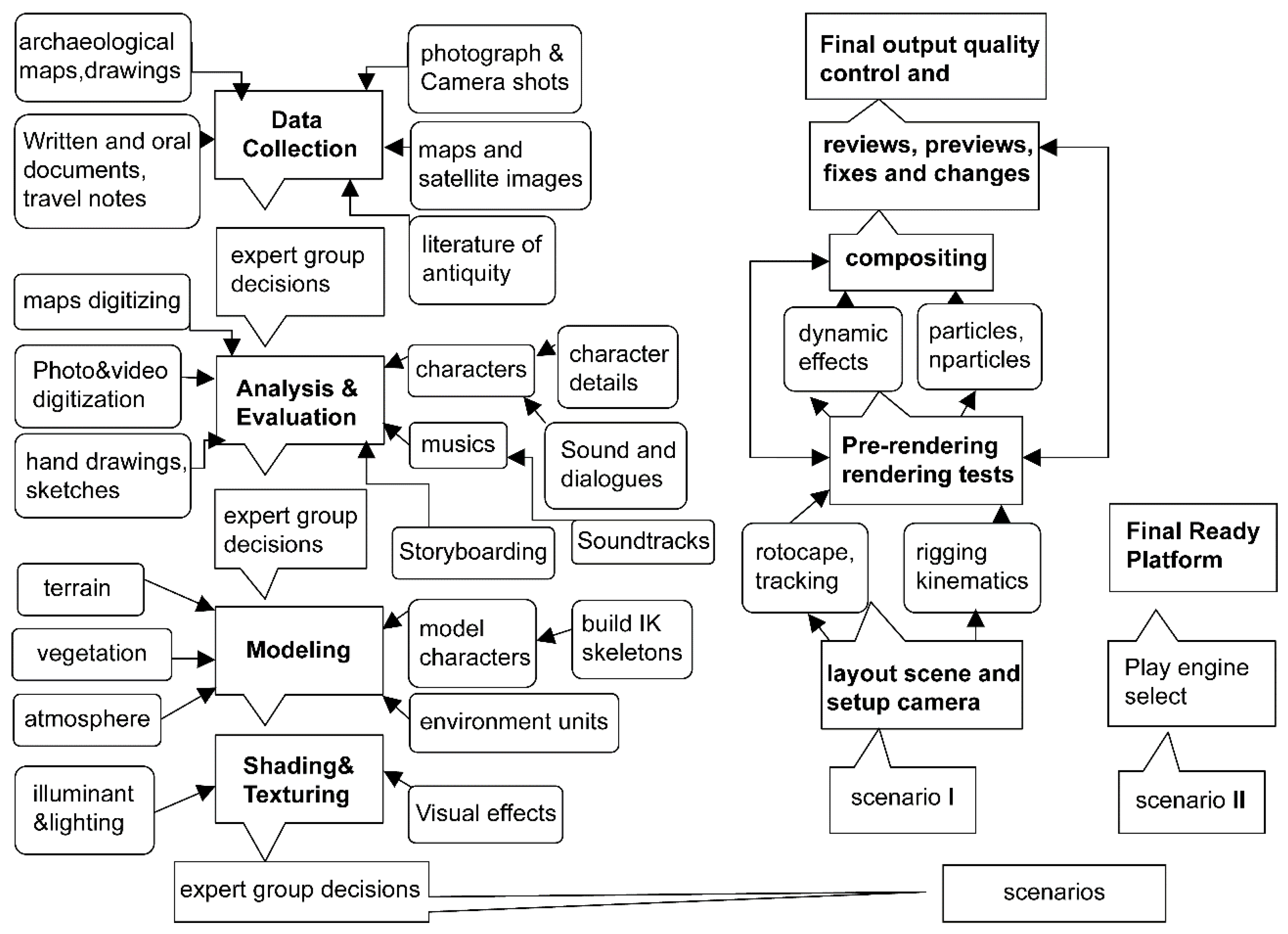
2. Methodologies: Historical Research, Technological Adaptation, and Esthetics
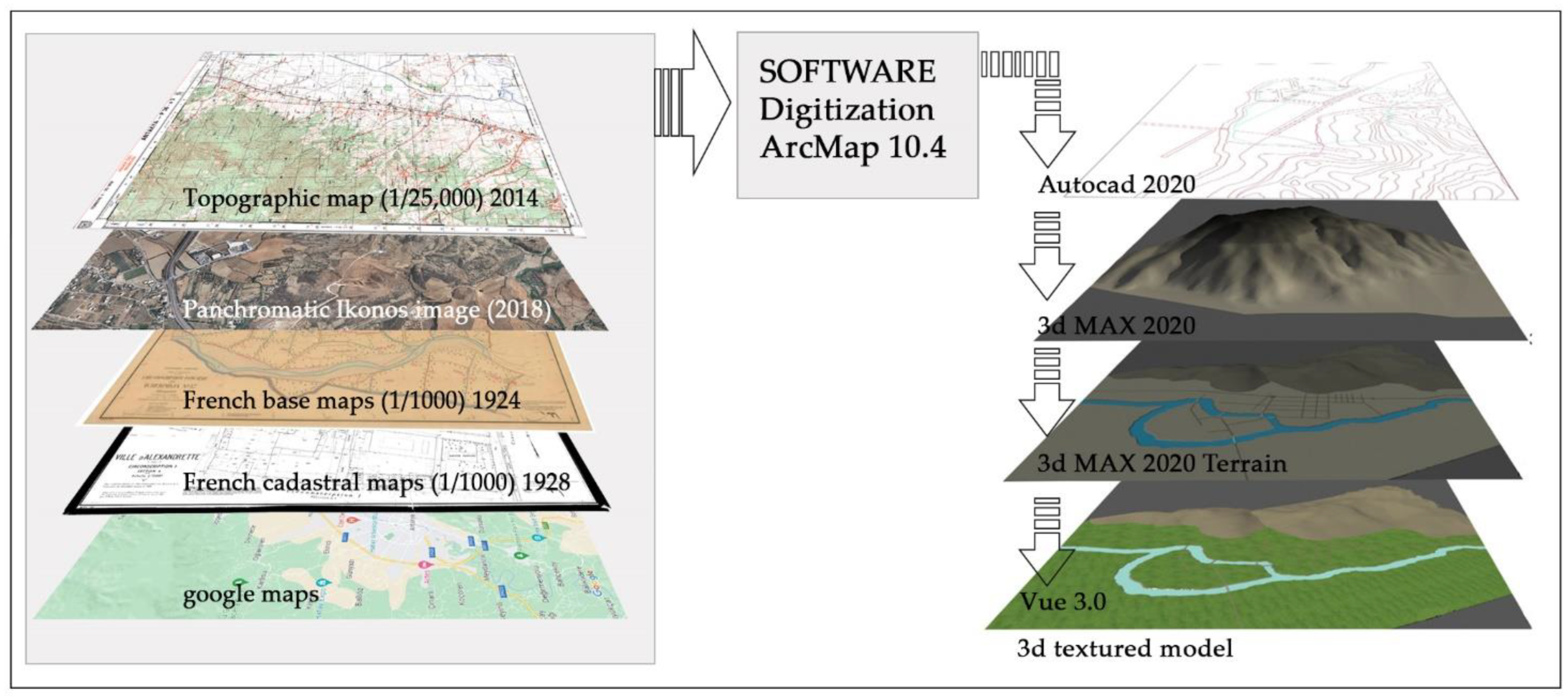
Because this is a scientific, social, historical, and esthetic study, mixed methodologies are used, especially Kerlow’s (2004) 3D computer-animation process [31]. This process is currently accepted and used in many commercial animated films, and here, it is further developed and adapted for this research process, which contains the following phases: data collection, analysis, modeling, coating, and rendering (Figure 1).
In addition, during the construction process of this study, the Rome Reborn project benefited significantly. As in the Rome Reborn Project, the buildings within the Ancient Antioch city are divided into two types. Class I elements (detailed models) are sites that have detailed information about identification, location, and design. Class II (procedural models) lack precise information, such as single-family houses, buildings, warehouses, etc. [16].
Two different scenarios are planned according to the assessment of the model’s success. In Scenario I, drama and animation are produced; in models, scenes contain characters walking different routes and having different perspectives. In addition to the animation presentation, Scenario II writes the model city into a real-time game engine that receives rendering from the model synchronically. Thanks to this engine, the researcher, student, or interested user can wander along any route within the ancient city.

Materials

As the longest and most important research phase, modeling was conducted with data obtained from expert decisions. In this study, in addition to models manufactured in previous studies, to save time, detailed and ready models were obtained from several sources (for instance, Internet libraries and software). In the process, modeling begins with creating topography or terrain. Two-dimensional numerical data obtained via the ArcGIS 2.8, (CA, USA) and AutoCAD 2020 (CA, USA) software from satellite views and maps was transferred into the Vue 3.0 (Paris, France) and 3D MAX 2020 (CA, USA) modeling software and then dimensioned.
At this stage, structures such as houses, buildings, or warehouses, as well as rural areas such as vegetation and fields, about which there is little information, were procedurally modeled with the Vue ecosystem module.
Thus, a numerical height model of the entire Hatay region was obtained. During this phase, along with vegetation, landscaping, rivers, lakes, climatic, and other environmental elements reflecting the period, models of the city, particular buildings, roads, and other structural elements were modeled. Temples, arenas, a Hippodrome, a forum, an agora, and city palaces were processed in detail from drawings and other media with authenticity paramount.
At this phase, however, not having the information necessary for modeling structures limited the study’s progress. Excavation notes provide information only pertaining to the planning and settling of structures; they fail to contain information about height, windows, roof cover, or any other details. Even extant textual information on a structure does not provide all the data necessary for a three-dimensional building model. Another modeling problem, for example, is that the sites of Ancient Antioch’s important structures are buried under earth in present-day Antakya—the situation prevents excavation at the desired level. Thus, at this phase, an important theoretical compromise occurs for the sake of continuing research; the textual information on other ancient cities, which might represent presence, plan, and scale, but whose height, roof cover, windows, door, and column details are not available, was used for modeling structures. For the type of modeling used in this example, the following criteria were considered: belonging to the same period, having conventional Roman architectural characteristics, and, if possible, proximity to the Antioch region. For character modeling, research was conducted on pictures, and the drafts were obtained. Characters’ clothing and equipment were modeled with diligence and aligned with expert advice. Nevertheless, even though every effort was made to base this study’s version of Ancient Antioch on adequate scientific evidence, the model is still open to comment. In the final analysis, the study’s visualized Antioch became a product of the project leader’s point of view, and this scientific, socio-historical study was thus transformed into a study of esthetics and became a work of art.
In the study, camera tracking and camera points of view are determined according to the ‘Scenario I’ method for obtaining animation. In this phase, routes and targets of the camera were chosen. In addition, the camera speed was adjusted to the dynamics of moving objects.
Throughout the study, ‘preliminary rendering’ was obtained from settings whose light, shade, and coatings were completed from the predetermined camera tracking and points of view. In this process, with advice about the latest forms of animations, settings that disturb the viewer’s eye or seem problematic in modeling or coating could be modified. Serving as a checkpoint, preliminary rendering was repeated for each camera point of view and moving object. Furthermore, character animations were created during this phase, and rendered images could be assessed.
Another method applied in Scenario II is the game engine. In rendering engines written in C++ computer language, all graphics must be written into the engine mathematically. After research into the necessary literature and previous studies, the decision was made to use an Object-Oriented Graphics Rendering Engine (OGRE) and Unity 3D. OGRE is an open-resource coded graphics processing and 3D game engine software group written and managed by a core team and supported by an increasing number of users. Unity 3D is the most common game engine used in the game and entertainment industry. The game engine’s software characteristics enable the researcher, student, or interested user to reach any point within the ancient city and to take synchronic rendering images connected to the camera from any point.

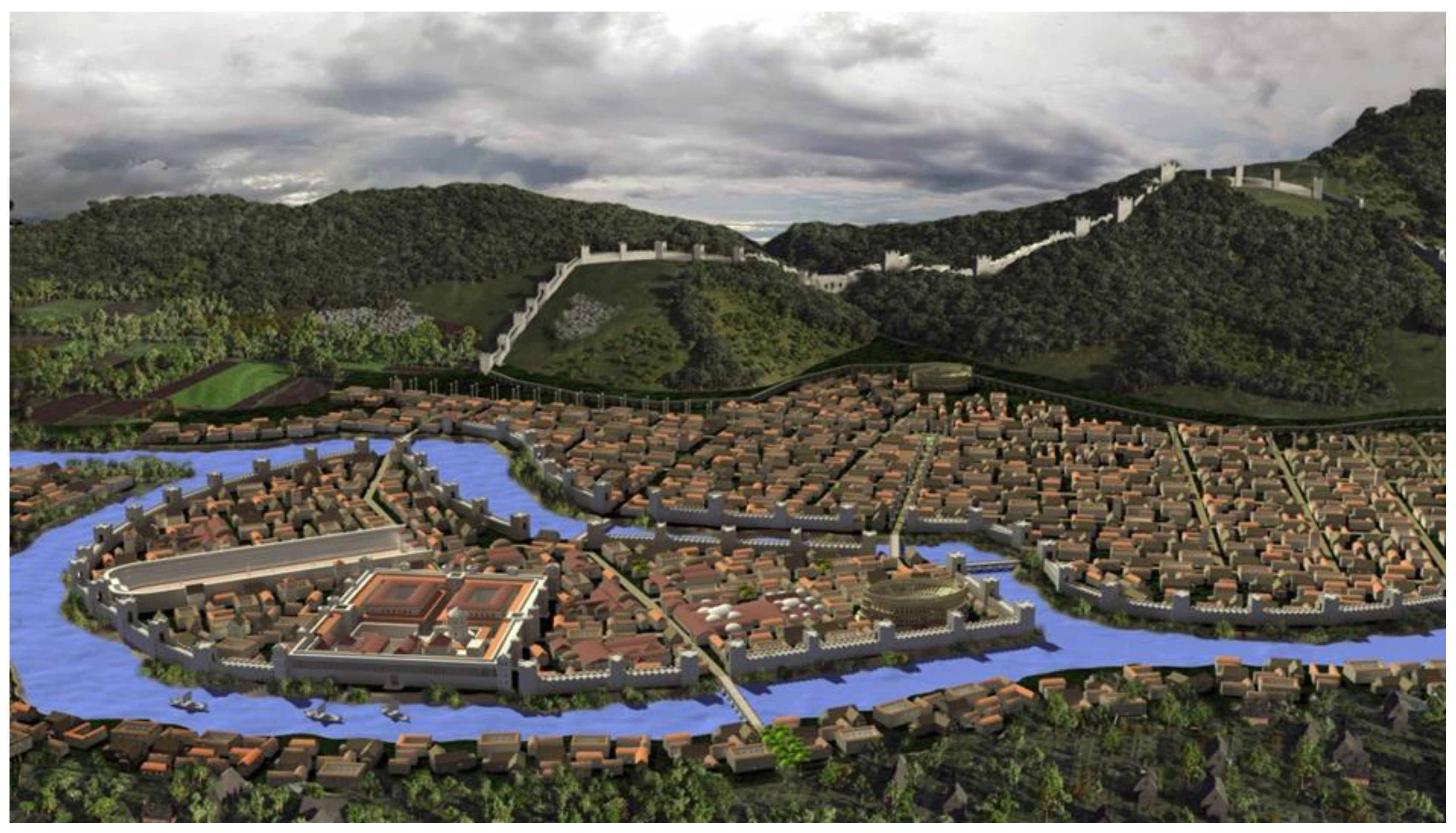
3. Results for the Example of Ancient Antioch

For modeling Ancient Antioch, the Roman period (40-350 CE) was chosen. First, the structures to be modeled were chosen, and resource information was obtained. To this end, Downey (1961) [32] and Uggeri’s (1996) [33] maps displaying Ancient Antioch were taken as a basis (Figure 2).
First, maps were started to be collected to create a 3D terrain model of Ancient Antioch. For this purpose, historical hand-drawn engravings, maps, and sketches were examined. The first topographical and cadastral studies in the region were started by the French in 1922. Those maps and updated 1/25,000 military topographic maps were compared and evaluated. In addition to these, historical and current satellite images were also used to ensure the accuracy of the data. As part of the Project, high resolution satellite images were used to support the general description of the ancient city under study and for the reconstruction of their topographies.
The results of this study include the creation of a composite historical database using ancient references and first topographical maps (1937 by France and later 1958), Landsat MSS (Multispectral Scanner System 1973, 1978, and 1988), Panchromatic Ikonos image (2018) data, and Sentinel1 (2018 and 2019) data. In this study, the data has been analyzed using the ArcMap 10.4 software.
The digital 2d maps were transferred to AutoCAD 2020 software. If there were deviations or distortions in the contour curves, they were checked and corrected. In this stage, AutoCAD software was used as a transmitter with a better 2D point control system. Later, these maps were converted into 3D terrain in 3D max 2020 software. Then, this terrain model was transferred to Vue 3.0 software and texture operations were performed (Figure 3). Vue 3.0 software is high photorealistic, and the animation controls are easy and fast., This software has been favored especially because it can quickly create crowded scenes as procedural with the ecosystem module.
The satellite images contribute little to the reconstruction of the Orontes River of the area of the Ancient Antioch; they merely show the current situation, with short water courses descending from the Sillipus mountain situated a little way to the East, perhaps following the same route as they did in ancient times. In the ancient city, we have more information about some important buildings, identity, location, and design information. Therefore, these structures were modeled in more detail. Of the structures in the city, the following were modeled: Colonnaded Street, the Imperial Palace, the Hippodrome, Nymphaeums, aqueducts, city walls, city gates, theater buildings, the amphitheater building, the stadium–arena, Tetrapol, the baths, and villas and houses (Figure 4).
The most important structures of Antioch city (e.g., the palace, circus, stadium–arena, and the Tetrapol) are situated on an island formed by the Orontes (Asi) River (Figure 5).

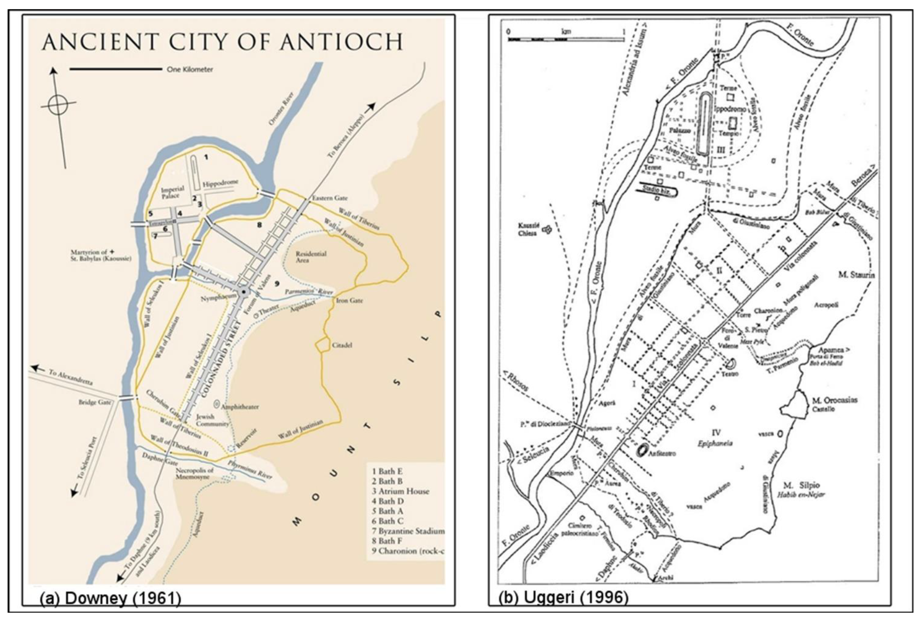
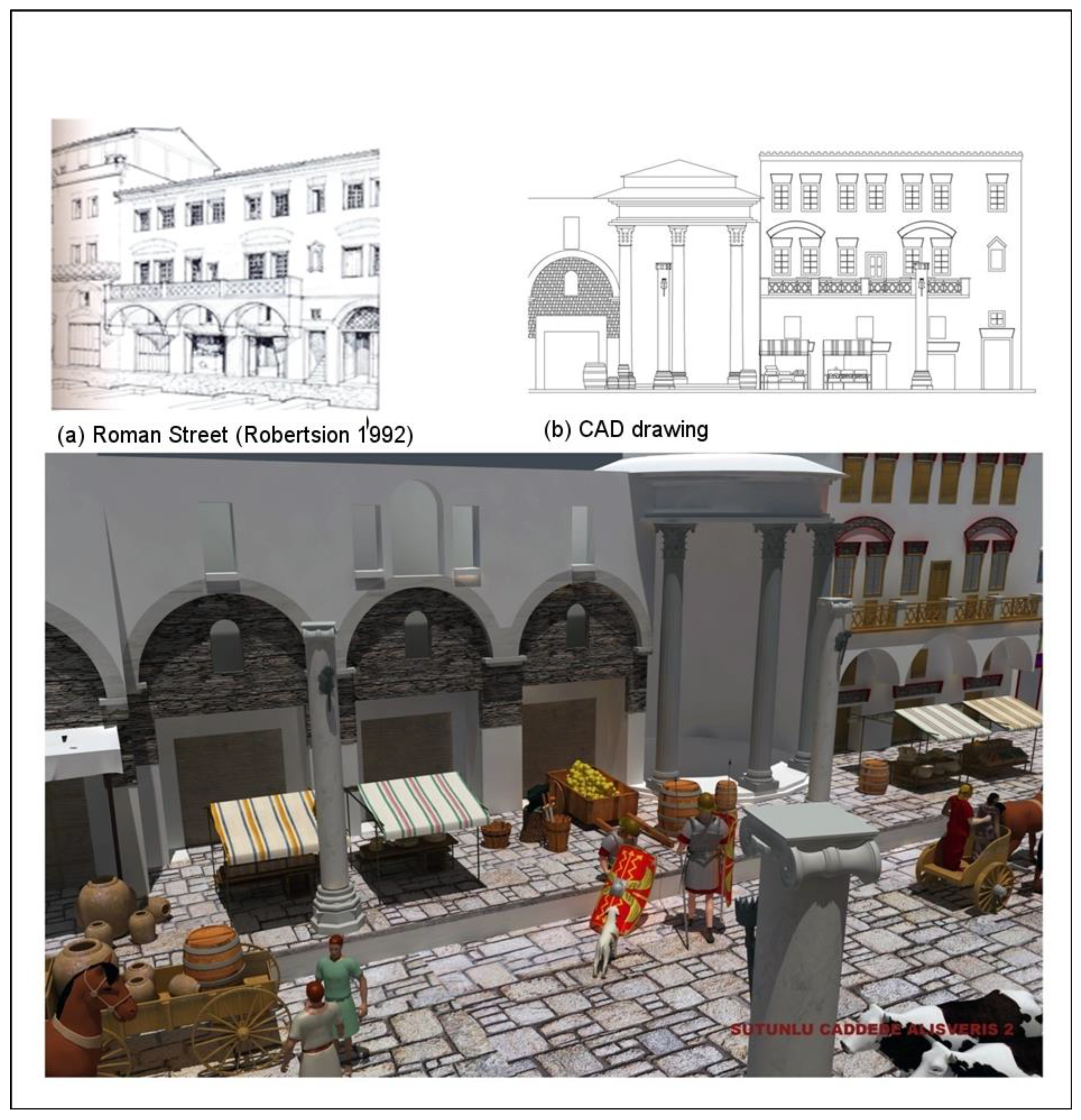
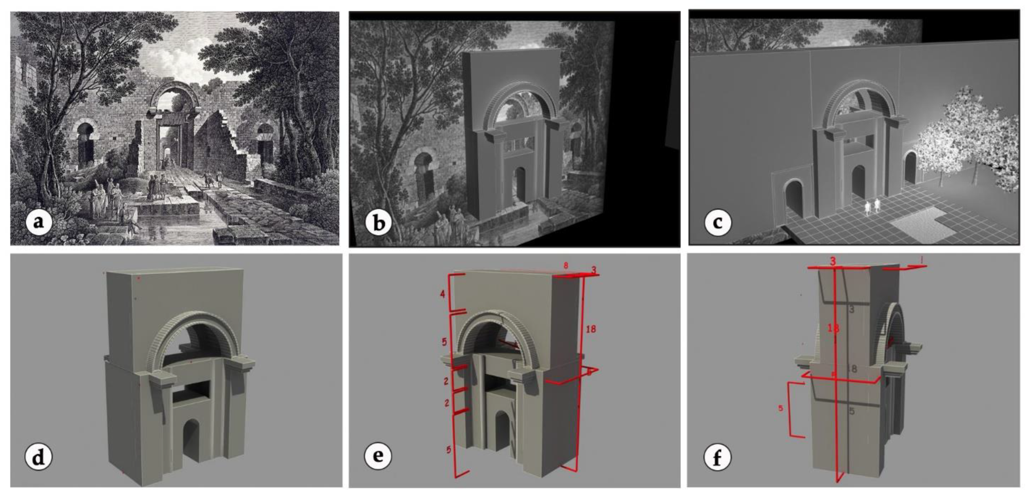
3.1. The Modeling of Ancient Antioch’s Colonnaded Street

Like other large structures in the Antioch of the Roman period, no part of Colonnaded Street has survived to the present day. For modeling Colonnaded Street, excavation notes, historical records, and expert comments were used. First, the works of Lassus, who performed excavation in Antakya in the 1930s, formed a foundation. According to his excavation reports (1972) [34], Colonnaded Street, which is 3400 m long, is situated 11 m beneath Antakya’s current Kurtulus Street.
As deduced from Downey’s and Uggeri’s maps and Lassus’s excavation notes, Colonnaded Street does not lie along the city section called Seleucid. Instead, the street is situated at the edge of Mount Silpius between Daphne and Beroea Gates within Epiphania. Antioch’s Colonnaded Street was maintained for eight centuries when Herod, Tiberius, Antonius Pius, and Justinian governed, but no structural changes were made. According to an expression of Libanius, the columns were lit in the evenings, and people would gather until late at night. At the same time, merchants hawked their ware at the sunder columned entrance [35].
Thus, Ancient Antioch’s Colonnaded Street was modeled according to these descriptions. First, columns were constructed and situated according to Downey’s map. Next, Lassus’s excavation notes formed the basis for the road’s width and length. Third, as mentioned by Lassus, buildings facing the street were modeled as shops. Finally, Roman architectural examples of the same period were used as designs for building facades (see Figure 6 for resource data [36,37].

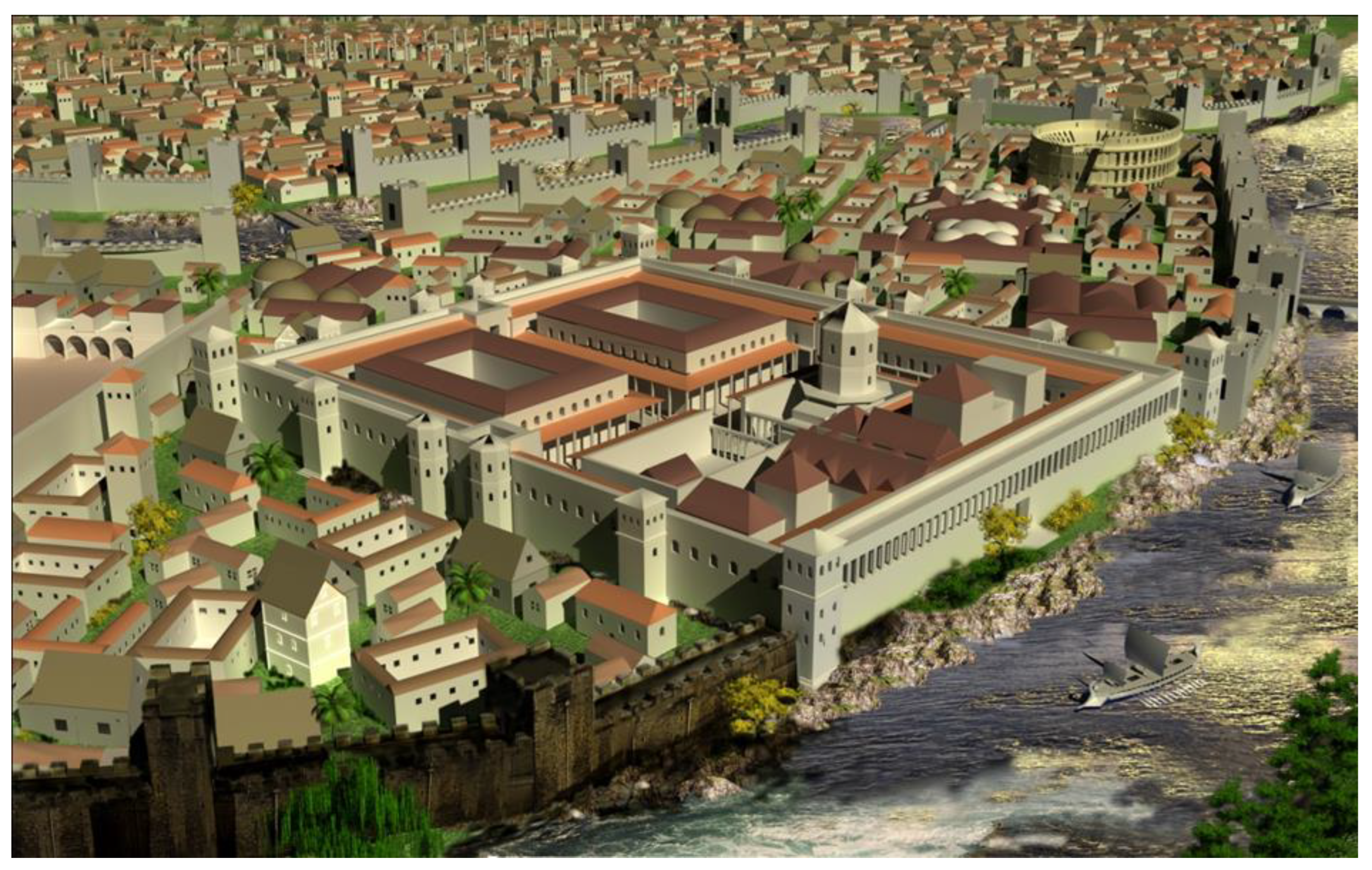
3.2. The Modeling of Ancient Antioch’s Imperial Palace

Malalas emphasized the high walls and complex structure of the Antioch Imperial Palace, which was constructed in 253 BC during the time of Gallienus. Similarly, Malalas also stated that King Trajan could see the Hippodrome from his chamber window in the Imperial Palace [38]. However, Libanus best described Antioch’s Imperial Palace; on the island, the palace was a magnificent structure surrounded by high walls. Its northern part was open to the Orontes River. Its chambers and corridors were supported with columns. It became famous for its size and dimensions, similar to the Palatine Palace complex and the Circus Maximus structure in Rome. However, it was considered similar to the Diocletian Palace in Split [39].
For this study, these historians’ expressions were used in terms of the shape and view for modeling the Antioch Imperial Palace. In addition, historical pictures and gravure paintings of Ancient Antioch provided information. The palace model was designed without detail and coating (Figure 7).

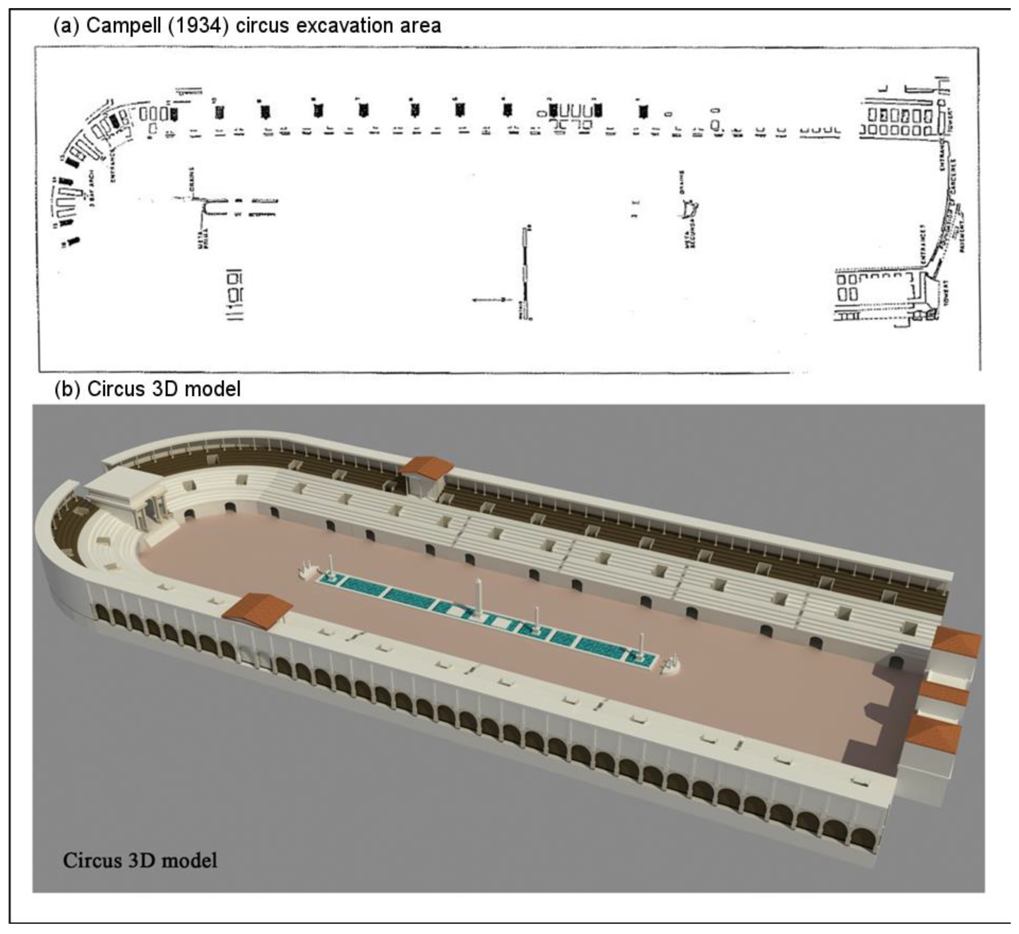
3.3. The Modeling of Ancient Antioch’s Hippodrome and Circus

Antioch city is located on the island’s center in Ancient Antakya; the Hippodrome is considered a part of the Imperial Palace complex, similar to the Maximus Hippodrome in Rome. As a hippodrome with a large capacity, this construction is thought to have accommodated 80,000 persons [40,41].
In the 1932 Antakya excavations by Princeton University, remains of the Hippodrome were found. Figure 8 shows a plan of the Hippodrome contained in excavation notes and the circus modeled according to this plan [40].
Using the plan, the excavation team discovered the eastern and northern parts of the Hippodrome and the internal and external walls of the arena section. In the excavations, the podium, primum maenianum, ambulacrum, and secundum maenianum were located. Furthermore, these excavations demonstrated that external walls were supported by columns to create a gallery.

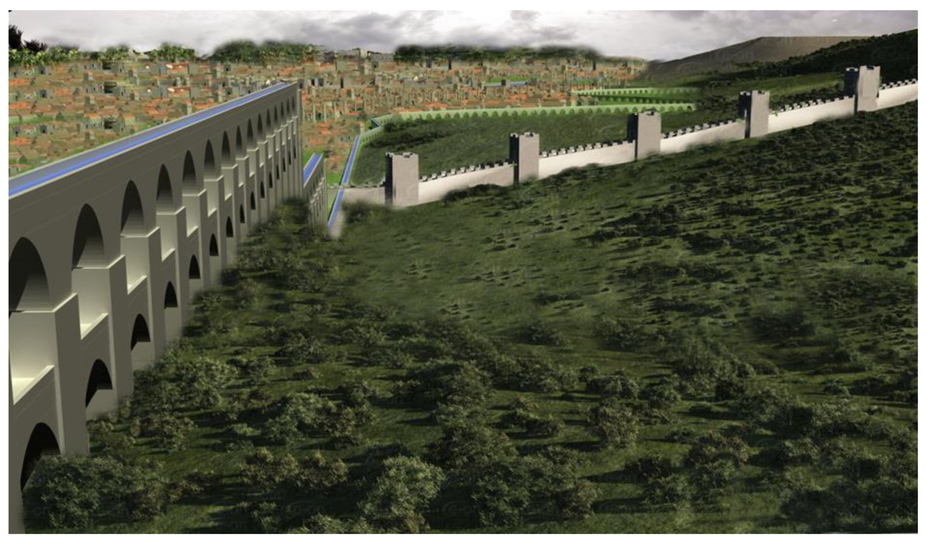
3.4. The Modeling of Ancient Antioch’s Aqueducts and Nymphaeums

In addition to its great buildings, Ancient Antioch is also famous for its water structures. According to information obtained by Demir (1996) [42], Antioch’s need for water was satisfied by the Daphne waterfalls, which flowed 2.8 km from the city. Water was transported through ducts and bridges. The water flow emerged from the channels (ducts and water bridges) and reached important tunnels and regions along the city.
Historical gravures and photographs are used in modeling and dimensioning aqueducts. Downey’s (1961) [32] and Uggeri’s (1996) [33] maps used in other studies aided in modeling water routes. Topographical structures between Daphne and Antioch were examined carefully, and an attempt was made to recreate these structures authentically (Figure 9).
Water reaching the city through ducts was collected in pools called nymphaeums. Thus, water was used functionally and esthetically; the nymphaeums, varying in size, served as gathering centers for Antioch’s population.

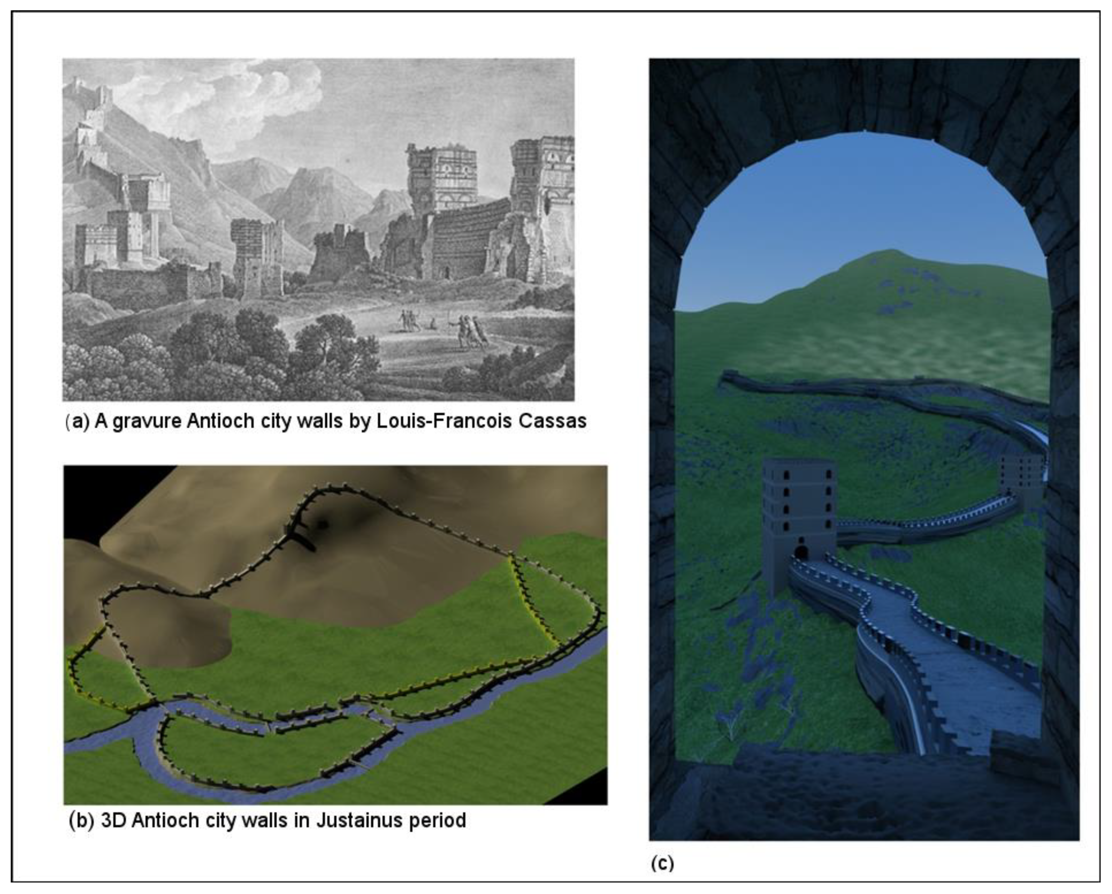
3.5. The Modeling of Ancient Antioch’s City Walls

Significant parts of Antioch’s walls still remain, especially in the east, over the crest of Mount Silpius. Much of the visible remains are dated to the Justinian walls of the sixth century; Justinian reduced the size of the city walls to align them with the much smaller Antioch of his time. However, several parts of what Hellenistic and Roman walls might be are also visible [43].
Antioch’s city walls were constructed in the 300s BC during the time of Seleukos I Nikator, who was among the generals of Alexander the Great. However, the walls took their essential structure and current status during the Justinian period. Estimated to be greater than 20 km in length, the city walls accommodated more than 300 towers [44].
Written resources and gravures were mainly assessed for modeling Ancient Antioch’s city walls. Gravures drawn in several periods were particularly useful for modeling and dimensioning city walls and towers (Figure 10).

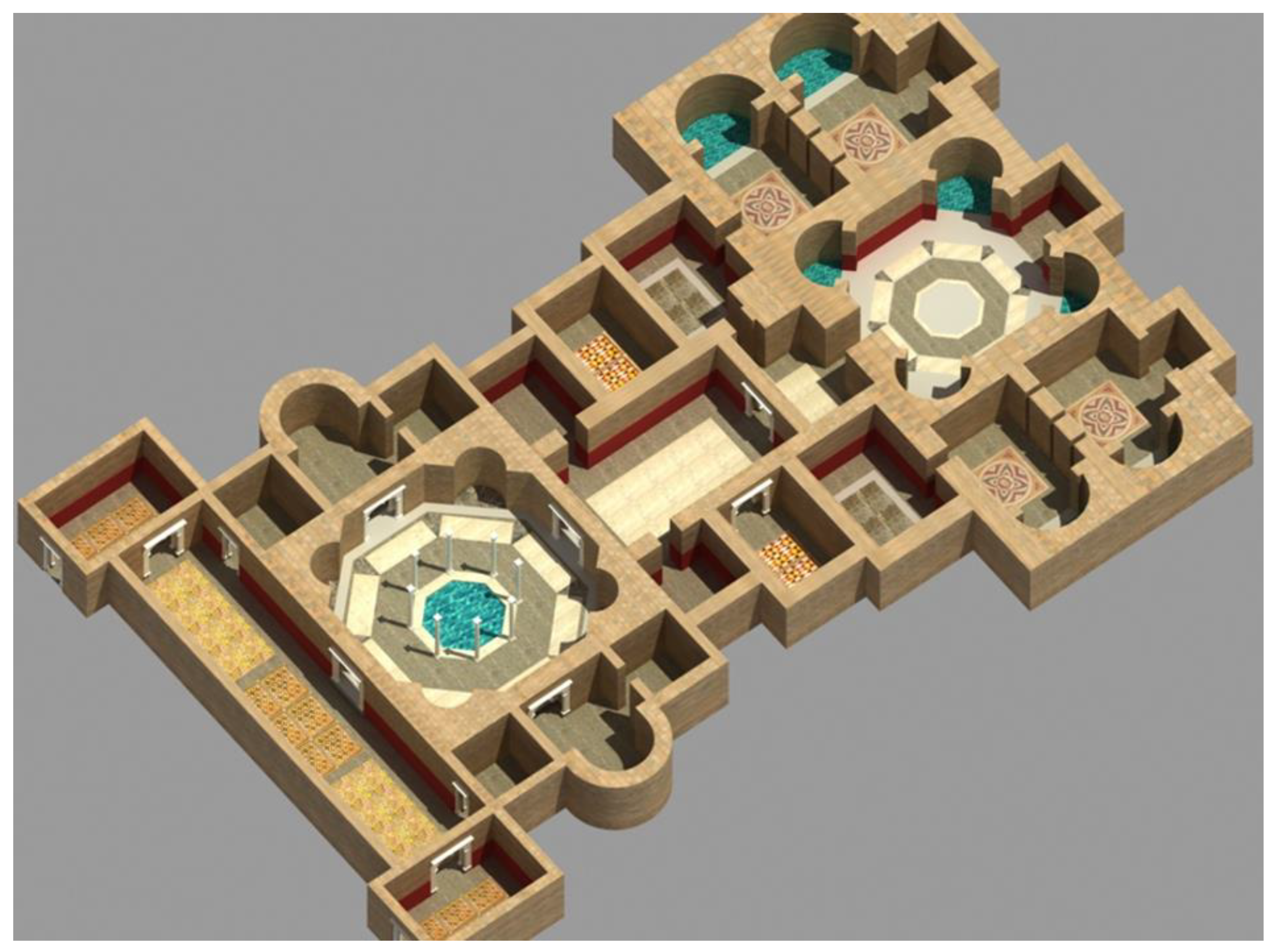
3.6. Modeling Ancient Antioch’s Houses and Baths

The excavation notes and studies from previous researchers (Pamir and Brands, 2005) [45] (Dobbings, 2000) [46] (Kondoleon, 2000) [27] (Gruber and Dobbings, 2013) [28] were mainly used for modeling Antioch’s houses and Roman baths. In the excavations of ancient Antioch, the remains of five large baths were found, which were called A, B, C, D, and E. Among them, bath C had the most data about the building (Figure 11).

4. Discussion and Conclusions

This research is important for revitalizing lost or destroyed cities, buildings, and their surroundings. Open areas such as roads, pavement, agoras, and avenues—as well as buildings—are modeled. Thus, open urban areas can be perceived in 3D and with depth, enabling experts to produce information and opinions more easily. With character modeling and the creation of dramas, we can reanimate cultural heritage by understanding the dimensional sizes and distances of outdoor social and economic life and recreational areas. Furthermore, this is new work in tracking past cities’ historical development because it covers various scientific branches (e.g., archeology, landscaping planning, urban planning, and computer-aided animation). Finally, this is a unique project due to its use of various scientific methods and software integration in fields such as remote perception, solid modeling, and animation.
The greatest limitation throughout the study was obtaining real data about the area or structure to be visualized and modeled. If we had decided to model structures whose dimensions and sizes were certain, only two or three buildings would have been realized, not the whole of Antioch, thus limiting our view of the city. Another problem lay in the absence of important structures’ (excavated) remains and their presence beneath several meters of present-day Antakya, where excavations at the desired level are not currently feasible.
Furthermore, the real-time engine (OGRE 3D) used for this study cannot fully operate at the desired level. Despite models produced throughout the study being transferred into the engine, problems occurred while localizing coatings because the software in which models are created and the coordinating software systems in the engine differ. In addition, the OGRE 3D game engine has been abandoned due to difficulties in use, interface complexity, and, most importantly, problems in the integration of models. After the necessary literature study and research, the Unity 3D game engine was used. This game engine is powerful, works across platforms, and is highly user-friendly to both beginners and experts. Unity 3D is a game engine that is advanced and renders real-world graphics without taking much processing power.
The integration with the Unity software, high-resolution panoramic images, and 3D model reconstructions is very successful [47]. Challenges to large-scale animation data visualization, including parallel animation data redundancy, huge data size, dynamic user interaction, and portability, are overcome through algorithms specifically designed for preprocessing simulation data and visualization modules optimized using the powerful 3D rendering and interactive game engine Unity 3D. A comparison of this study with various visualization tools and realistic simulations commonly used to visualize large-scale idealized datasets highlights the visualization efficiency, seamless interaction, and lightweight properties of Ancient Antioch.
Therefore, foundational research such as this is significant for early results that are rich in visual quality. We can expect constantly improving images for the preservation, analysis, and interpretation of cultural heritage—whether for the ultimate purpose of introduction, education, or research.
In particular, this research is important for animating ancient cities. The example used here involved recreating Ancient Antakya’s historical past and introducing its culture, particularly through presentations in museums and art galleries. The images and animations from this study are used in the Hatay Archeology Museum (Figure 12).
Perhaps the most important output of this study was the use of almost all of the images obtained in the Hatay Archaeology Museum. The visuals and animations of this study are shown on the TV screens in the museum exhibition areas and the museum movie hall. After March 2023, it is planned that the presentation of Ancient Antioch will be opened to visitors on special platforms with Unity 3D, which is at the final stage of preparations.
Practical uses of the methodologies and materials include an animation of Antioch during the Roman period for short films and documentaries (Figure 13). In addition, all the animation, images, and drawings obtained through this study will be transferred into an easily accessible DVD format. Therefore, this study not only introduces Antioch but also can be a resource for undergraduates and postgraduates studying history, the history of art, and archeology departments.
Furthermore, the images obtained through this study will be an important data resource for archeology and excavation, providing 3D information and helping determine the direction of excavations, particularly those in progress around Antioch.
This model is not just a visualization either; it helps to reveal new information as well by conjoining previously disconnected knowledge into one place. Our volumetric and multi-perspective view of the ancient city allows us to answer new questions about the tradition, culture, and philosophy of the society, as well as their reciprocal relationship to the built environment. Along with being an academic tool, the model is also a valuable cultural tool that can expand the understanding of the world of Ancient Antioch history and rekindle its place in Rome’s Antioch memory and identity.
Finally, this study can serve to motivate similar studies in other regions. For example, when dramas and 3D animations are presented visually during simulation and consultation phases, an excavation team can form opinions and plans about its future work. In other words, a new synthetic process enables an ongoing feedback loop; an actual excavation area’s data can be constantly modeled and remodeled, thus improving both the scientific feasibility, quality, and uniqueness of excavation work and the practical dissemination of scientific results.

Funding

Study is funded by ‘the Scientific Technological Research Council of Turkey’ (TÜBİTAK) as the project numbered 107K278.

Conflicts of Interest

The authors declare no conflict of interest. The funders had no role in the design of the study; in the collection, analyses, or interpretation of data; in the writing of the manuscript, or in the decision to publish the results.

References

  1. Ervin, S.M. Digital Landscape Modeling and Visualization: A Research Agenda. Landsc. Urban Plan. 2001, 54, 49–62. [Google Scholar] [CrossRef]
  2. Koutsoudis, A.; Stavroglou, K.; Pavlidis, G.; Chamzas, C. 3DSSE—A 3D Scene Search Engine. Exploring 3D Scenes Using Keywords. J. Cult. Herit. 2012, 13, 187–194. [Google Scholar] [CrossRef]
  3. Gutierrez, D.; Seron, F.J.; Magallon, J.A.; Sobreviela, E.J.; Latorre, P. Archaeological and Cultural Heritage: Bringing Life to an Unearthed Muslim Suburb in an Immersive Environment. J. Cult. Herit. 2004, 5, 63–74. [Google Scholar] [CrossRef]
  4. Bruno, F.; Bruno, S.; de Sensi, G.; Luchi, M.L.; Mancuso, S.; Muzzupappa, M. From 3D Reconstruction to Virtual Reality: A Complete Methodology for Digital Archaeological Exhibition. J. Cult. Herit. 2010, 11, 42–49. [Google Scholar] [CrossRef]
  5. Rua, H.; Alvito, P. Living the Past: 3D Models, Virtual Reality and Game Engines as Tools for Supporting Archaeology and the Reconstruction of Cultural Heritage—The Case-Study of the Roman Villa of Casal de Freiria. J. Archaeol. Sci. 2011, 38, 3296–3308. [Google Scholar] [CrossRef]
  6. Fontana, R.; Greco, M.; Materazzi, M.; Pampaloni, E.; Pezzati, L.; Rocchini, C.; Scopigno, R. Three-Dimensional Modelling of Statues: The Minerva of Arezzo. J. Cult. Herit. 2002, 3, 325–331. [Google Scholar] [CrossRef]
  7. Koutsoudis, A.; Arnaoutoglou, F.; Chamzas, C. On 3D Reconstruction of the Old City of Xanthi. A Minimum Budget Approach to Virtual Touring Based on Photogrammetry. J. Cult. Herit. 2007, 8, 26–31. [Google Scholar] [CrossRef]
  8. Liritzis, I.; Al-Otaibi, F.M.; Volonakis, P.; Drivaliari, A. Digital Technologies and Trends in Cultural Heritage. Mediterr. Archaeol. Archaeom. 2015, 15, 313–332. [Google Scholar] [CrossRef]
  9. Besoain, F.; González-Ortega, J.; Gallardo, I. An Evaluation of the Effects of a Virtual Museum on Users’ Attitudes towards Cultural Heritage. Appl. Sci. 2022, 12, 1341. [Google Scholar]
  10. Schweibenz, W. The Virtual Museum: An Overview of Its Origins, Concepts, and Terminology. Digitisation of Photographs (Art) View Project Personas for Museums View Project. Mus. Rev. 2019, 4, 1–29. [Google Scholar]
  11. Chrysanthi, A.; Ant, A.; Chrysant, A.; Perry, S.; Roussou, M. Cultural heritage and social experiences in the times of COVID 19. In Proceedings of the 2020 AVI2CH Workshop on Advanced Visual Interfaces and Interactions in Cultural Heritage, Ischia, Italy, 29 September 2020. [Google Scholar]
  12. Marín-Morales, J.; Higuera Trujillo, J.L.; Greco, A.; Guixeres, J.; Llinares, C.; Gentili, C.; Scilingo, E.; Alcañiz Raya, M.; Valenza, G. Real vs. Immersive-Virtual Emotional Experience: Analysis of Psycho-Physiological Patterns in a Free Exploration of an Art Museum. PLoS ONE 2019, 14, e0223881. [Google Scholar] [CrossRef] [Green Version]
  13. Theodoropoulos, A.; Antoniou, A. VR Games in Cultural Heritage: A Systematic Review of the Emerging Fields of Virtual Reality and Culture Games. Appl. Sci. 2022, 12, 8476. [Google Scholar] [CrossRef]
  14. Döker, M.F.; Kırlangıçoğlu, C. Promotion of Cultural Heritages Through A Virtual Museum Platform: Case Study Hagia Sophia. Sak. Univ. J. Sci. 2018, 22, 1337–1345. [Google Scholar] [CrossRef]
  15. Damiano, R.; Lombardo, V.; Lieto, A.; Borra, D. Exploring Cultural Heritage Repositories with Creative Intelligence. The Labyrinth 3D System. Entertain. Comput. 2016, 16, 41–52. [Google Scholar] [CrossRef] [Green Version]
  16. Dylla, K.A.; Müller, P.; Ulmer, A.; Haegler, S.; Frischer, B. Rome Reborn 2.0 a framework for virtual city reconstruction using procedural modeling techniques. In Proceedings of the 37th Annual International Conference on Computer Applications and Quantitative Methods in Archaeology (CAA), Williamsburg, VA, USA, 22–26 March 2009. [Google Scholar]
  17. Frischer, B.; Guidi, G.; Lucenti, I. Rome Reborn-Virtualizing the ancient imperial Rome. In Workshop on 3D Virtual Reconstruction and Visualization of Complex Architectures; Fondazione Bruno Kessler: Trento, Italy, 2007. [Google Scholar]
  18. Denker, A. Rebuilding Palmyra Virtually: Recreation of Its Former Glory in Digital Space. Virtual Archaeol. Rev. 2017, 8, 20–30. [Google Scholar] [CrossRef] [Green Version]
  19. Denker, A. Vırtual palmyra: 3d reconstructıon of the lost realıty of the brıde of the desert. In Proceedings of the 8th International Congress on Archaeology, Computer Graphics, Cultural Heritage and Innovation ‘ARQUEOLÓGICA 2.0’, Valencia, Spain, 5–7 September 2016; MIT Press: Cambridge, MA, USA, 2016; pp. 318–321. [Google Scholar]
  20. Bobou, O.; Kristensen, N.B.; McAvoy, S.; Raja, R. Archive Archaeology in Palmyra, Syria a New 3D Reconstruction of the Tomb of Ḥairan. Digit. Appl. Archaeol. Cult. Herit. 2020, 19, e00164. [Google Scholar] [CrossRef]
  21. Khorloo, O.; Ulambayar, E.; Altantsetseg, E. Virtual Reconstruction of the Ancient City of Karakorum. Comput. Animat. Virtual Worlds 2022, 33, e2087. [Google Scholar] [CrossRef]
  22. Ferwati, M.S.; el Menshawy, S. Virtual Reconstruction of the Historic City of Al-Zubarah in Qatar. Digit. Appl. Archaeol. Cult. Herit. 2021, 21, e00177. [Google Scholar] [CrossRef]
  23. Smith, M.; Walford, N.S.; Jimenez-Bescos, C. Using 3D Modelling and Game Engine Technologies for Interactive Exploration of Cultural Heritage: An Evaluation of Four Game Engines in Relation to Roman Archaeological Heritage. Digit. Appl. Archaeol. Cult. Herit. 2019, 14, e00113. [Google Scholar] [CrossRef]
  24. Haegler, S.; Müller, P.; van Gool, L. Procedural Modeling for Digital Cultural Heritage. EURASIP J. Image Video Process. 2009, 2009, 1–11. [Google Scholar] [CrossRef] [Green Version]
  25. Denard, H. Implementing Best Practice in Cultural Heritage Visualisation: The London Charter BT—Good Practice in Archaeological Diagnostics: Non-Invasive Survey of Complex Archaeological Sites; Corsi, C., Slapšak, B., Vermeulen, F., Eds.; Springer International Publishing: Cham, Switzerland, 2013; pp. 255–268. ISBN 978-3-319-01784-6. [Google Scholar]
  26. Denard, H. The London charter for the computer-based visualisation of cultural heritage. In Paradata and Transparency in Virtual Heritage; Routledge: London, UK, 2009; pp. 99–104. [Google Scholar]
  27. Kondoleon, C. (Ed.) Antioch: The Lost Ancient City; Princeton University Press: Princeton, NJ, USA, 2000; ISBN 978-0691049335. [Google Scholar]
  28. Kloeg, S.P. Antioch the Great Population and Economy of Second-Century Antioch. Master’s Thesis, Leiden University, Leiden, The Netherlands, 2013. [Google Scholar]
  29. Sbeinati, M.R.; Darawcheh, R.; Mouty, M. The Historical Earthquakes of Syria: An Analysis of Large and Moderate Earthquakes from 1365 B.C. to 1900 A.D. Ann. Geophys. 2005, 48, 347–435. [Google Scholar] [CrossRef]
  30. Sandwell, I.; Huskinson, J. Culture and Society in Late Roman Antioch; Oxbow Books: Oxford, UK, 2003; ISBN 978-1842171028. [Google Scholar]
  31. Kerlow, I. The Art of 3D Computer Animation and Effects, 3rd ed.; John Wiley Sons, Inc.: Hoboken, NJ, USA, 2004; ISBN 978-0470084908. [Google Scholar]
  32. Downey, G. A History of Antioch in Syria: From Seleucus to the Arab Conquest; Reprint of; Princeton University Press: Princeton, NJ, USA, 1961; ISBN 978-1258486655. [Google Scholar]
  33. Uggeri, G. Antiochia Sull’Oronte Nel IV Secolo d. C. In Proceedings of the Atti II Congress Topografia Antica, Roman Town-Planning, Rome, 15–16 May 1996; pp. 179–222. [Google Scholar]
  34. Lassus, J. Antioch on-the-Orontes V, Les Portiques d’Antioch. Committee for the Excavation of Antioch and Its Vicinity; Princeton University Press: Princeton, NJ, USA, 1972. [Google Scholar]
  35. Norman, A.F. Libanius: Autobiography and Selected Letters; Cambridge University Press: London, UK, 1993; ISBN 0-674-99527-9. [Google Scholar]
  36. Robertson, D.S. Greek and Roman Architecture; Cambridge University Press: London, UK, 1992; ISBN 978-0521094528. [Google Scholar]
  37. Ward-Perkins, J.B. Roman Imperial Architecture; Yale University Press: New Haven, Connecticut, 1992; ISBN 978-0300052923. [Google Scholar]
  38. Guidetti, F. Urban continuity and change in late Roman Antioch. In urban decline. In the byzantine realm. In Proceedings of the International Conference Acta Byzantina Fennica, Helsinki, Finland, 25 September 2010; Volume 3, pp. 81–104. [Google Scholar]
  39. Ecclestone, C. Antiochepedia = Musings upon Ancient Antioch. Available online: http://libaniusredux.blogspot.com.tr/html. (accessed on 15 October 2014).
  40. Campbell, W.A. Excavations at Antioch-on-the-Orontes. Am. J. Archaeol. 1934, 38, 201–206. [Google Scholar] [CrossRef]
  41. Wilmott, T. Roman Amphitheatres and Spectacula, a 21st-Century Perspective: Papers from an International Conference Held at Chester, 16–18 February 2007; Archaeopress: Oxford, UK, 2009; ISBN 9781407304267. [Google Scholar]
  42. Demir, A. Çağlar Içinde Antakya; Akbank Kültür ve Sanat Kitapları: İstanbul, Turkey, 1996. [Google Scholar]
  43. Brands, G. Antike Welt; Zeitschrift für Archäologie und Kunstgeschichte: Darmstadt, Germany, 2004; Volume 35, pp. 10–16. [Google Scholar]
  44. Williams, S. Diocletian and the Roman Recovery; Routledge: London, UK, 2000; ISBN 0415918278. [Google Scholar]
  45. Pamir, H.; Gunner, B. The Asi delta and the Asi valley archaeological project in 2004: Samandağ and antakya surveys. In Proceedings of the News of Archaeology from Anatolıa’s Medıterranean Areas (ANMED), Ankara, Turkey, 29–30 May 2005; pp. 103–108. [Google Scholar]
  46. Dobbins, J. The houses of Antioch. In Antioch: The Lost Ancient City; Kondoleon, C., Ed.; Princeton University Press: Princeton, NJ, USA, 2000; pp. 74–82. ISBN 978-0691049335. [Google Scholar]
  47. Clini, P.; Ruggeri, L.; Angeloni, R.; Sasso, M. Interactive immersive virtualmuseum: Digital documentation for virtual interaction. In Proceedings of the International Archives of the Photogrammetry, Remote Sensing and Spatial Information Sciences—ISPRS Archives, Riva del Garda, Italy, 30 May 2018; Volume 42, pp. 251–257. [Google Scholar]
Figure 1. Visualization process for the ancient city of Antioch.
Applsci 12 12316 g001
Figure 2. (a) Downey’s (1961) map and (b) Uggeri’s (1996) map of Ancient Antioch.
Applsci 12 12316 g002
Figure 3. 3D terrain model construction stages of ancient Antioch.
Applsci 12 12316 g003
Figure 4. Model of Ancient Antioch (shown from South to North).
Applsci 12 12316 g004
Figure 5. Model of Ancient Antioch as situated along the Orontes River.
Applsci 12 12316 g005
Figure 6. Shop buildings with Roman architecture of the ancient period, modeled for virtual Antioch, with data sources above.
Applsci 12 12316 g006
Figure 7. Ancient Antioch’s Imperial Palace on the island in the Orontes River.
Applsci 12 12316 g007
Figure 8. Campell’s (1934) [21] circus excavation area and model produced from his plan.
Applsci 12 12316 g008
Figure 9. Ancient Antioch’s modeled aqueducts from the Daphne waterfalls.
Applsci 12 12316 g009
Figure 10. An 18th-century gravure by Louis-Francois Cassas [25] depicting Ancient Antioch’s city walls (a), and the model produced from this gravure (b,c).
Applsci 12 12316 g010
Figure 11. Model of Roman bath C, Ancient Antioch.
Applsci 12 12316 g011
Figure 12. Three-dimensional Antioch images in Hatay Archeology Museum.
Applsci 12 12316 g012
Figure 13. An animation about the Beroea (Medina) Gate: (a) Cassas’ engraving of the Beroea gate, (b,c) modeling of the 3d gate from the engraving (df) Animation frames showing the dimensions of the Gate.
Applsci 12 12316 g013
Publisher’s Note: MDPI stays neutral with regard to jurisdictional claims in published maps and institutional affiliations.

