
Extracting the Maritime Traffic Route in Korea Based on Probabilistic Approach Using Automatic Identification System Big Data


Abstract
:1. Introduction
2. Materials and Methods
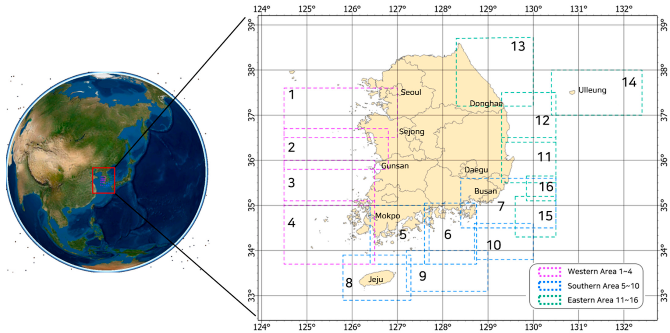
2.1. Analysis Area
2.2. Overview of Extracting the Korean Maritime Traffic Route
2.3. Preprocessing and Statistical Analysis of AIS Data Used for Analysis
2.4. Density Analysis for Extracting Main Maritime Traffic Routes
2.5. Related Study and Application to Extract Vessel Passage
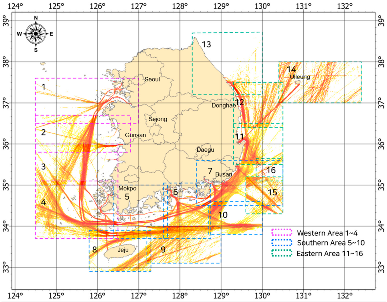
3. Results of the Korean Maritime Traffic Route Analysis
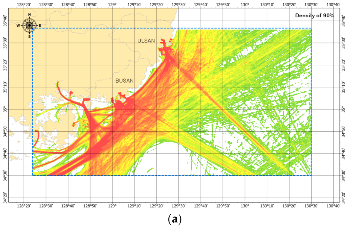
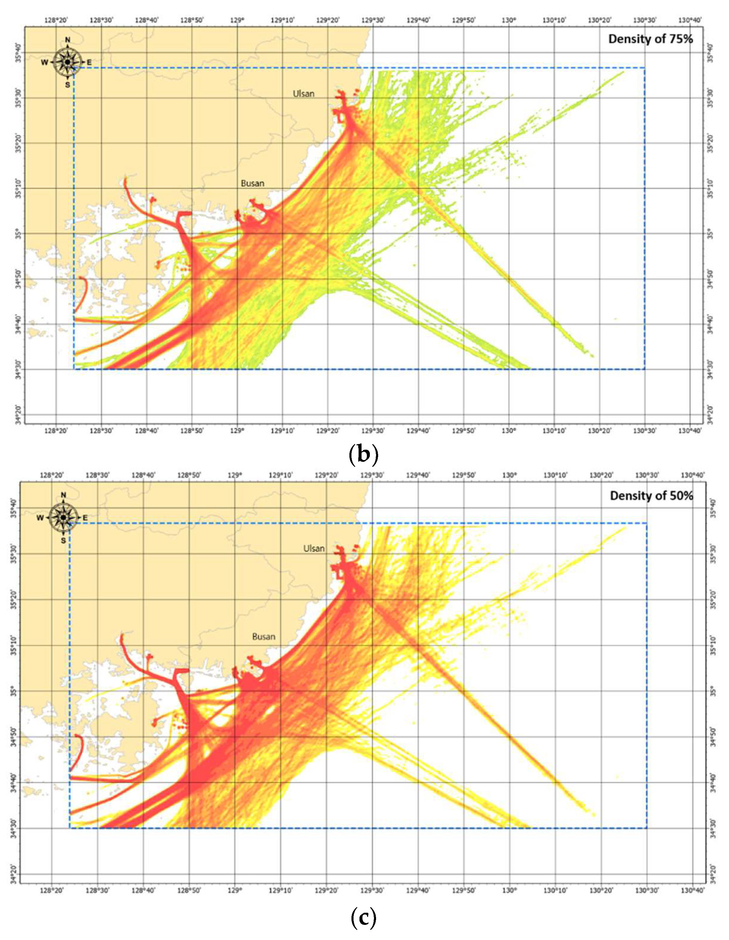
3.1. Results of Main Maritime Traffic Routes Based on Density Analysis
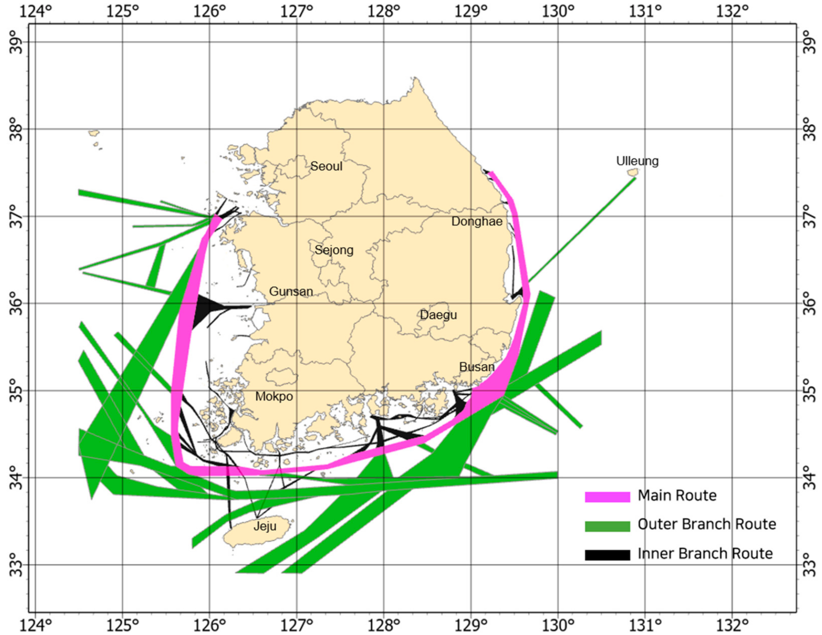
3.2. The Korean Maritime Traffic Route Classification and Definition
3.2.1. Definition of the Main Route
3.2.2. Definition of the Outer Branch Route
3.2.3. Definition of the Inner Branch Route
3.3. The Result of Korean Maritime Traffic Main Route as Polygon
4. Discussion
5. Conclusions and Future Work
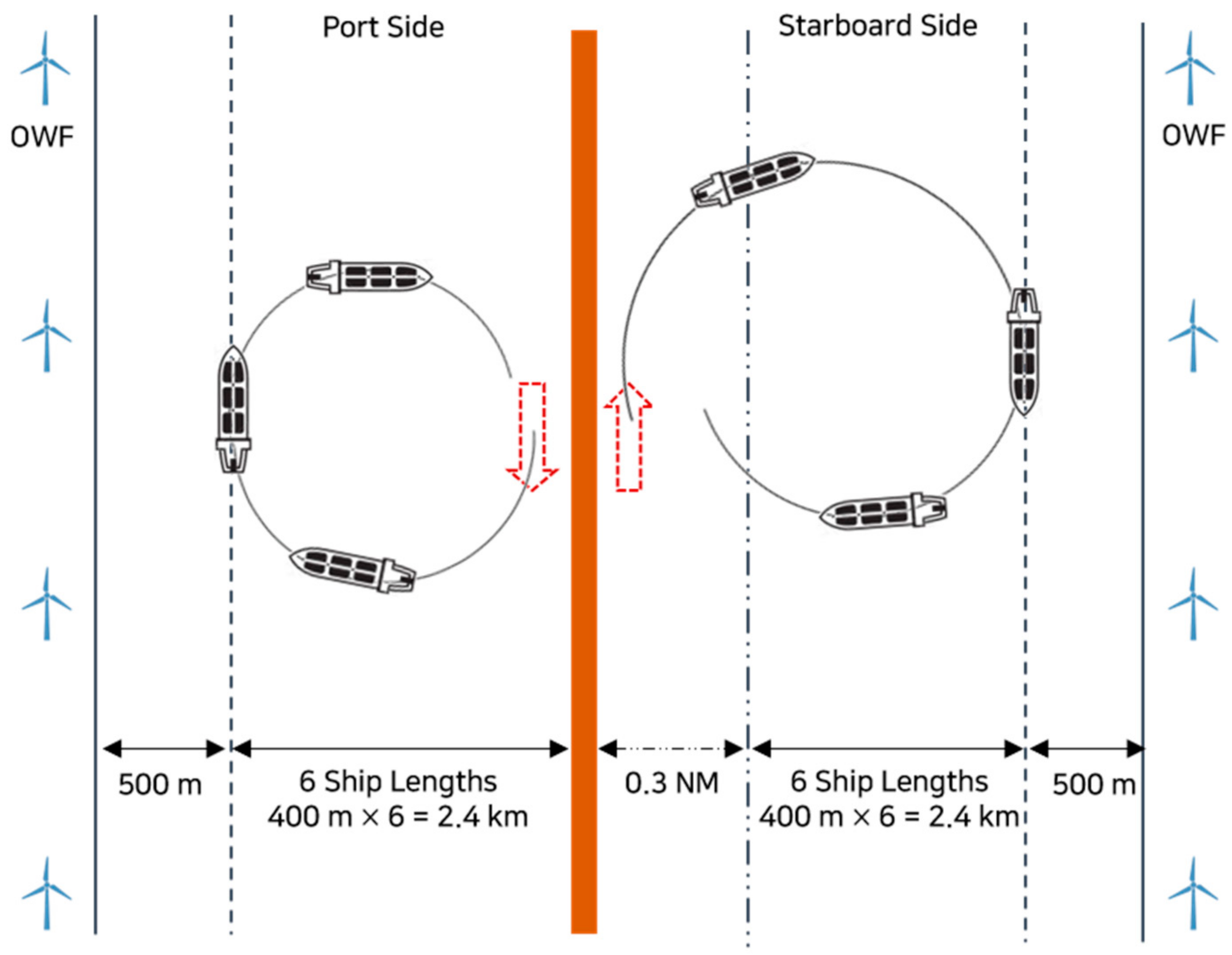
- First, it is to protect the area of the new and renewable energy zone that is being actively developed recently and the area of the ship passage within the MSP. So far, the domestic shipping area has only been protected in a very small area, which is restricted to the vicinity of ports. To keep ship routes to a minimum, a 50% density analysis was used for cargo ships, tanker ships, passenger ships, and towing ships larger than 60 m, but not all ships. This result does not use all the data, and it is essential to keep the area to which these ships navigate. Based on the density analysis result, it is divided into three routes: the main routes, the outer branch route, and the inner branch route. Once again, it is divided into routes that cannot be moved or changed and routes that allow movement and change through appropriate regulations.
- Second, domestic maritime traffic routes are designed to respond to the emergence of MASS in the future. The massive amount of AIS data used in this analysis is a historical record of ships operating safely and efficiently. If a ship’s navigation route is chosen with such conviction based on data, it is determined that it can be applied to the route of future ships. If a country’s maritime route is selected and major waypoints are presented, it is expected that MASS will be able to use a route that connects the world beyond one country.
Author Contributions
Funding
Institutional Review Board Statement
Informed Consent Statement
Data Availability Statement
Conflicts of Interest
References
- Tu, E.; Zhang, G.; Rachmawati, L.; Rajabally, E.; Huang, G.-B. Exploiting AIS Data for Intelligent Maritime Navigation: A Comprehensive Survey from Data to Methodology. IEEE Trans. Intell. Transp. Syst. 2018, 19, 1559–1582. [Google Scholar] [CrossRef]
- United Nations. U.N. Conference on Trade and Development, Review of Maritime Transport; United Nation Publication: New York, NY, USA; Geneva, Switzerland, 2019; Volume 2019, pp. 14–20. [Google Scholar]
- Weng, J.; Yang, D. Investigation of Shipping Accident Injury Severity and Mortality. Accid. Anal. Prev. 2015, 76, 92–101. [Google Scholar] [CrossRef] [PubMed]
- Lee, J.S.; Son, W.J.; Lee, H.T.; Cho, I.S. Verification of Novel Maritime Route Extraction Using Kernel Density Estimation Analysis with Automatic Identification System Data. J. Mar. Sci. Eng. 2020, 8, 375. [Google Scholar] [CrossRef]
- Yan, Z.; Xiao, Y.; Cheng, L.; Chen, S.; Zhou, X.; Ruan, X.; Li, M.; He, R.; Ran, B. Analysis of Global Marine Oil Trade Based on Automatic Identification System (AIS) Data. J. Transp. Geogr. 2020, 83, 102637. [Google Scholar] [CrossRef]
- Redfern, J.V.; Mckenna, M.F.; Moore, T.J.; Calambokidis, J.; Deangelis, M.L.; Becker, E.A.; Barlow, J.; Forney, K.A.; Fiedler, P.C.; Chivers, S.J. Assessing the Risk of Ships Striking Large Whales in Marine Spatial Planning. Conserv. Biol. 2013, 27, 292–302. [Google Scholar] [CrossRef] [PubMed]
- Kardakaris, K.; Boufidi, I.; Soukissian, T. Offshore Wind and Wave Energy Complementarity in the Greek Seas Based on ERA5 Data. Atmosphere 2021, 12, 1360. [Google Scholar] [CrossRef]
- Lee, J.S.; Son, W.J.; Lee, H.T.; Cho, I.S. A Study on the Factors Affecting Optimal Site of Offshore Wind Farm from the Perspective of Maritime Traffic Using Spatial Analysis. Korea Soc. Coast. Disaster Prev. 2020, 7, 85–96. [Google Scholar] [CrossRef]
- Soukissian, T. Use of Multi-Parameter Distributions for Offshore Wind Speed Modeling: The Johnson SB Distribution. Appl. Energy 2013, 111, 982–1000. [Google Scholar] [CrossRef]
- Lee, J.S.; Son, W.J.; Lee, B.K.; Cho, I.S. Optimal Site Selection of Floating Offshore Wind Farm Using Genetic Algorithm. J. Korean Soc. Mar. Environ. Saf. 2019, 25, 658–665. [Google Scholar] [CrossRef]
- Douvere, F. The Importance of Marine Spatial Planning in Advancing Ecosystem-Based Sea Use Management. Mar. Policy 2008, 32, 762–771. [Google Scholar] [CrossRef]
- Lee, J.S. A Study on Navigable Spatial Planning Using Big Data on Maritime Traffic in Geographic Information System Environment. Master’s Thesis, Korea Maritime and Ocean University, Busan, Korea, 2020. [Google Scholar]
- Son, W.J.; Lee, J.S.; Lee, H.T.; Cho, I.S. An Investigation of the Ship Safety Distance for Bridges across Waterways Based on Traffic Distribution. J. Mar. Sci. Eng. 2020, 8, 331. [Google Scholar] [CrossRef]
- Yan, Z.; Xiao, Y.; Cheng, L.; He, R.; Ruan, X.; Zhou, X.; Li, M.; Bin, R. Exploring AIS Data for Intelligent Maritime Routes Extraction. Appl. Ocean Res. 2020, 101, 102271. [Google Scholar] [CrossRef]
- Hu, Y.; Zhang, A.; Tian, W.; Zhang, J.; Hou, Z. Multi-Ship Collision Avoidance Decision-Making Based on Collision Risk Index. J. Mar. Sci. Eng. 2020, 8, 640. [Google Scholar] [CrossRef]
- Murray, B.; Perera, L.P. An AIS-Based Deep Learning Framework for Regional Ship Behavior Prediction. Reliab. Eng. Syst. Saf. 2021, 215, 107819. [Google Scholar] [CrossRef]
- Wang, L.; Chen, P.; Chen, L.; Mou, J.; Ship, A.I.S. Ship AIS Trajectory Clustering: An HDBSCAN-Based Approach. J. Mar. Sci. Eng. 2021, 9, 566. [Google Scholar] [CrossRef]
- Arguedas, V.F.; Pallotta, G.; Vespe, M. Maritime Traffic Networks: From Historical Positioning Data to Unsupervised Maritime Traffic Monitoring. IEEE Trans. Intell. Transp. Syst. 2018, 19, 722–732. [Google Scholar] [CrossRef]
- Froti, N.; Millefiori, L.M.; Braca, P. Unsupervised Extraction of Maritime Patterns of Life from Automatic Identification System Data; OCEANS: Marseille, France, 2019. [Google Scholar]
- Millefiori, L.M.; Braca, P.; Bryan, K.; Willett, P. Modeling Vessel Kinematics Using a Stochastic Mean-Reverting Process for Long-Term Prediction. IEEE Trans. Aerosp. Electron. Syst. 2016, 52, 2013–2330. [Google Scholar]
- Millefiori, L.M.; Braca, P.; Arcieri, G. Scalable Distributed Change Detection and Its Application to Maritime Traffic. In Proceedings of the IEEE International Conference on Big Data, Boston, MA, USA, 11–14 December 2017. [Google Scholar]
- Millefiori, L.M.; Braca, P.; Willett, P.; Millefiori, L.M.; Braca, P.; Willett, P. Consistent Estimation of Randomly Sampled Ornstein–Uhlenbeck Process Long-Run Mean for Long-Term Target State Prediction. IEEE Signal Process. Lett. 2016, 23, 1562–1566. [Google Scholar] [CrossRef]
- Ester, M.; Kriegel, H.P.; Sander, J.; Xu, X. A Density-Based Algorithm for Discovering Clusters in Large Spatial Databases with Noise. In International Conference on Data Mining and Knowledge Discovery; University of Munich Oettingenstr: Munich, Germany, 1996; Volume 4, pp. 226–231. [Google Scholar]
- Wang, G.; Meng, J.; Han, Y. Extraction of Maritime Road Networks from Large-Scale AIS data. IEEE Access 2019, 7, 123035–123048. [Google Scholar] [CrossRef]
- Lee, H.T.; Lee, J.S.; Yang, H.; Cho, I.S.; An, A.I.S. An AIS Data-Driven Approach to Analyze the Pattern of Ship Trajectories in Ports Using the DBSCAN Algorithm. Appl. Sci. 2021, 11, 799. [Google Scholar] [CrossRef]
- Lee, H.T.; Lee, J.S.; Son, W.J.; Cho, I.S. Development of Machine Learning Strategy for Predicting the Risk Range of Ship’s Berthing Velocity. Mar. Sci. Eng. 2020, 8, 376. [Google Scholar] [CrossRef]
- Serry, A. The Automatic Identification System (AIS): A Data Source for Studying. In Maritime Transportmarit; IDEES: Barcelone, Spain, 2016. [Google Scholar]
- Zhang, X.; Wang, C.; Liu, Y.; Chen, X. Decision-Making for the Autonomous Navigation of Maritime Autonomous Surface Ships Based on Scene Division and Deep Reinforcement Learning. Sensors 2019, 19, 4055. [Google Scholar] [CrossRef] [Green Version]
- Lee, C.H.; Kim, Y.S.; Shin, Y.R. Data Usage and the Legal Stability of Transactions for the Commercial Operation of Autonomous Vessels Based on Digital Ownership in Korean Civil Law. Sustainability 2021, 13, 8134. [Google Scholar] [CrossRef]
- Jovíc, M.; Tijan, E.; Žgaljíc, D.; Aksentijevíc, S. Improving Maritime Transport Sustainability Using Blockchain-Based Information Exchange. Sustainability 2020, 12, 8866. [Google Scholar] [CrossRef]
- Sheng, P.; Yin, J.b. Extracting Shipping Route Patterns by Trajectory Clustering Model Based on Automatic Identification System Data. Sustainability 2018, 10, 2327. [Google Scholar] [CrossRef] [Green Version]
- Lu, N.; Liang, M.; Zheng, R.; Liu, R.W. Historical AIS Data-Driven Unsupervised Automatic Extraction of Directional Maritime Traffic Networks. In Proceedings of the IEEE 5th International Conference on Cloud Computing and Big Data Analytics (ICCCBDA), Chengdu, China, 10–13 April 2020. [Google Scholar]
- Le, T.M.; Le, G.D.; Gourmelon, F.; Queffelec, B. How Can Automatic Identification System Data Be Used for Maritime Spatial Planning? Ocean Coast. Manag. 2018, 166, 18–30. [Google Scholar]
- Hamada, K.; Wada, Y.; Nanao, J.; Watanabe, D.; Majima, T. Long-Term Ship Position Prediction Using Automatic Identification System (AIS) Data and End-to-End Deep Learning. Sensors 2021, 21, 7169. [Google Scholar]
- Lampe, O.D.; Hauser, H. Interactive Visualization of Streaming Data with Kernel Density Estimation. In IEEE Pacific Visualization Symposium; IEEE: Hong Kong, China, 2011. [Google Scholar]
- Botev, Z.I.; Grotowski, J.F.; Kroese, D.P. Kernel Density Estimation via Diffusion. Ann. Statist. 2010, 38, 2916–2917. [Google Scholar] [CrossRef] [Green Version]
- United Nations. U.N. Convention on the Law of the Sea; Part V, Article 60; United Nations Publicaiton: New York, NY, USA; Geneva, Switzeland, 1982; p. 45. [Google Scholar]
- UK Maritime & Coastguard Agency. MGN 543(M+F) Safety of Navigation: Offshore Renewable Energy Installations(ORELs). In Safety of Navigation: Offshore Renewable Energy Installations (ORELs)—Guidance on UK Navigational Practice, Safety and Emergency Response; MCA: Southampton, UK, 2016; pp. 7–23.
- FPS (The Federal Public Service). Marine Spatial Plan for the Belgian Part of the North Sea; FPS: Brussels, Belgium, 2016; pp. 42–43. [Google Scholar]
- Zhang, L.; Meng, Q.; Fang Fwa, T.F. Big AIS Data Based Spatial-Temporal Analyses of Ship Traffic in Singapore Port Waters. Transp. Res. E 2019, 129, 287–304. [Google Scholar] [CrossRef]
- Kvanli, A.H.; Pavur, R.J.; Keeling, K.B. Concise Managerial Statistics; Cengage Learning: Boston, MA, USA, 2006; pp. 81–82. ISBN 9780324223880. [Google Scholar]
- Chernick, M.R. The Essentials of Biostatistics for Physicians, Nurses, and Clinicians; John & Wiley Sons: New York, NY, USA, 2011; pp. 49–50. ISBN 9780470641859. [Google Scholar]
- MOF. Harbour and Fishery Design Criteria; Ministry of Oceans and Fisheries of Korea: Sejong, Korea, 2017. [Google Scholar]
- PIANC (The world Association for Waterborne Transport Infrastructure). MarCom Working Group 161: Interaction between Offshore Wind Farms and Maritime Navigation-Design Guidelines; PIANC: Brussels, Belgium, 2018. [Google Scholar]


| No. | Latitude | Longitude | No. | Latitude | Longitude |
|---|---|---|---|---|---|
| Area 1 | 36.50° N–37.60° N | 124.50° E–127.00° E | Area 9 | 33.10° N–34.00° N | 127.20° E–129.00° E |
| Area 2 | 35.80° N–36.70° N | 124.50° E–126.80° E | Area 10 | 33.80° N–34.60° N | 128.70° E–130.00° E |
| Area 3 | 35.00° N–36.00° N | 124.50° E–126.80° E | Area 11 | 35.50° N–36.50° N | 129.30° E–130.50° E |
| Area 4 | 33.70° N–35.10° N | 124.50° E–126.50° E | Area 12 | 36.40° N–37.50° N | 129.30° E–130.50° E |
| Area 5 | 33.70° N–35.00° N | 126.40° E–127.70° E | Area 13 | 37.20° N–38.70° N | 128.30° E–130.00° E |
| Area 6 | 33.70° N–35.05° N | 127.60° E–128.75° E | Area 14 | 37.00° N–38.00° N | 130.40° E–132.40° E |
| Area 7 | 34.50° N–35.60° N | 128.40° E–130.50° E | Area 15 | 34.30° N–35.20° N | 129.60° E–130.50° E |
| Area 8 | 32.90° N–33.90° N | 125.80° E–127.30° E | Area 16 | 35.10° N–35.65° N | 129.85° E–130.50° E |
| Categorization | AIS |
|---|---|
| Data Period | 1 January 2018–31 December 2018 1 September 2019–31 August 2020 |
| Data Volume | Approx. 1.1 TB |
| Analysis Area | Republic of Korea |
| Ship Type | Cargo Ship, Tanker Ship, Passenger Ship, Towing ship |
| Ship Length | 60 m or Over of Ship’s Type (≥60 m) |
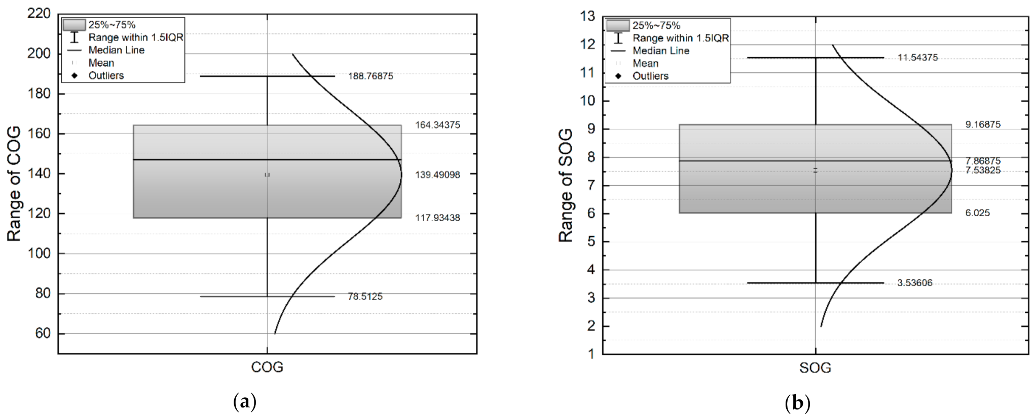
| Area | Data Counting | COG (°) | SOG (kts) | GT (ton) | Length (m) |
|---|---|---|---|---|---|
| Mean | Mean | Mean | Mean | ||
| Area 1 | 7,125,269 | 171.1 | 5.9 | 13,403.4 | 131.3 |
| Area 2 | 2,424,427 | 140.4 | 9.2 | 17,477.7 | 144.8 |
| Area 3 | 2,360,251 | 158.0 | 8.8 | 14,927.5 | 129.5 |
| Area 4 | 7,249,111 | 188.8 | 9.6 | 26,748.6 | 159.0 |
| Area 5 | 3,712,294 | 154.1 | 8.4 | 10,769.9 | 116.8 |
| Area 6 | 8,023,942 | 170.4 | 6.1 | 12,811.6 | 111.2 |
| Area 7 | 14,654,929 | 169.2 | 3.8 | 14,419.0 | 122.2 |
| Area 8 | 2,954,921 | 134.5 | 8.5 | 17,348.6 | 128.6 |
| Area 9 | 2,744,786 | 119.2 | 11.5 | 41,535.5 | 172.3 |
| Area 10 | 1,464,791 | 116.7 | 11.0 | 33,849.4 | 160.8 |
| Area 11 | 4,664,982 | 152.0 | 3.5 | 73,756.7 | 120.8 |
| Area 12 | 1,322,681 | 159.5 | 7.9 | 16,218.0 | 118.3 |
| Area 13 | 959,212 | 142.2 | 6.2 | 6844.9 | 96.7 |
| Area 14 | 931,028 | 80.9 | 6.5 | 14,566.8 | 99.3 |
| Area 15 | 857,881 | 96.4 | 6.4 | 19,763.3 | 109.8 |
| Area 16 | 661,153 | 78.5 | 6.0 | 21,415.2 | 110.9 |
| No. | Threshold of 90% | Threshold of 75% | Threshold of 50% | Standard Deviation | Mean |
|---|---|---|---|---|---|
| Area 1 | 166 | 332 | 664 | 863 | 224 |
| Area 2 | 52 | 104 | 234 | 275 | 124 |
| Area 3 | 72 | 145 | 217 | 228 | 132 |
| Area 4 | 86 | 173 | 281 | 373 | 239 |
| Area 5 | 132 | 308 | 551 | 549 | 236 |
| Area 6 | 207 | 345 | 552 | 810 | 443 |
| Area 7 | 177 | 444 | 799 | 796 | 403 |
| Area 8 | 90 | 180 | 316 | 279 | 233 |
| Area 9 | 131 | 196 | 268 | 208 | 258 |
| Area 10 | 57 | 173 | 385 | 353 | 293 |
| Area 11 | 73 | 184 | 332 | 305 | 233 |
| Area 12 | 47 | 78 | 118 | 108 | 93 |
| Area 13 | 48 | 96 | 144 | 105 | 36 |
| Area 14 | 26 | 52 | 79 | 50 | 40 |
| Area 15 | 55 | 105 | 161 | 177 | 163 |
| Area 16 | 104 | 160 | 225 | 116 | 188 |
| Vertex No. | Width of Main Route (km) | Difference (km) | Vertex No. | Width of Main Route (km) | Difference (km) |
|---|---|---|---|---|---|
| 1 | 11.04 | +4.64 | 18 | 18.86 | +12.46 |
| 2 | 7.23 | +0.83 | 19 | 27.64 | +21.24 |
| 3 | 8.49 | +2.09 | 20 | 25.66 | +19.26 |
| 4 | 13.77 | +7.39 | 21 | 27.71 | +21.31 |
| 5 | 15.00 | +8.60 | 22 | 26.83 | +20.43 |
| 6 | 7.89 | +1.49 | 23 | 24.21 | +17.81 |
| 7 | 7.45 | +1.05 | 24 | 21.46 | +15.06 |
| 8 | 9.23 | +2.83 | 25 | 12.69 | +6.29 |
| 9 | 10.06 | +3.66 | 26 | 10.43 | +4.03 |
| 10 | 11.48 | +5.08 | 27 | 8.47 | +2.07 |
| 11 | 6.11 | −0.29 | 28 | 5.93 | −0.47 |
| 12 | 6.14 | −0.26 | 29 | 7.29 | +0.89 |
| 13 | 10.24 | +3.84 | 30 | 6.04 | −0.36 |
| 14 | 7.65 | +1.25 | 31 | 5.50 | −0.90 |
| 15 | 7.29 | +0.89 | 32 | 5.05 | −1.35 |
| 16 | 10.09 | +3.69 | 33 | 6.46 | +0.06 |
| 17 | 16.19 | +9.79 |
Publisher’s Note: MDPI stays neutral with regard to jurisdictional claims in published maps and institutional affiliations. |
© 2022 by the authors. Licensee MDPI, Basel, Switzerland. This article is an open access article distributed under the terms and conditions of the Creative Commons Attribution (CC BY) license (https://creativecommons.org/licenses/by/4.0/).
Share and Cite
Lee, J.-S.; Cho, I.-S. Extracting the Maritime Traffic Route in Korea Based on Probabilistic Approach Using Automatic Identification System Big Data. Appl. Sci. 2022, 12, 635. https://doi.org/10.3390/app12020635
Lee J-S, Cho I-S. Extracting the Maritime Traffic Route in Korea Based on Probabilistic Approach Using Automatic Identification System Big Data. Applied Sciences. 2022; 12(2):635. https://doi.org/10.3390/app12020635
Chicago/Turabian StyleLee, Jeong-Seok, and Ik-Soon Cho. 2022. "Extracting the Maritime Traffic Route in Korea Based on Probabilistic Approach Using Automatic Identification System Big Data" Applied Sciences 12, no. 2: 635. https://doi.org/10.3390/app12020635
APA StyleLee, J.-S., & Cho, I.-S. (2022). Extracting the Maritime Traffic Route in Korea Based on Probabilistic Approach Using Automatic Identification System Big Data. Applied Sciences, 12(2), 635. https://doi.org/10.3390/app12020635