


Flood Risk Assessment Using GIS-Based Analytical Hierarchy Process in the Municipality of Odiongan, Romblon, Philippines

 ,
,  ,
,  and
and
Abstract
1. Introduction
2. Materials and Methods
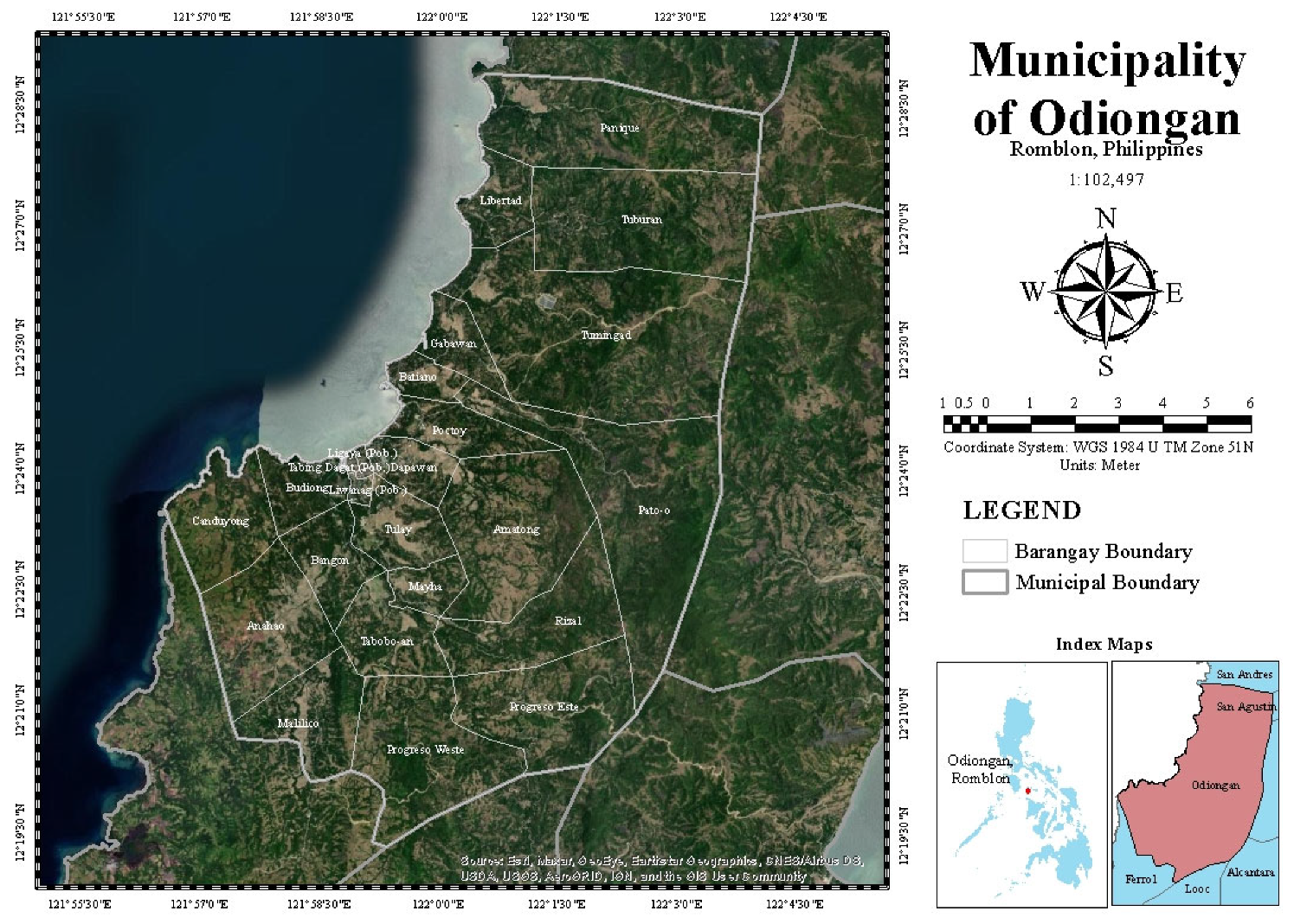
2.1. Study Area
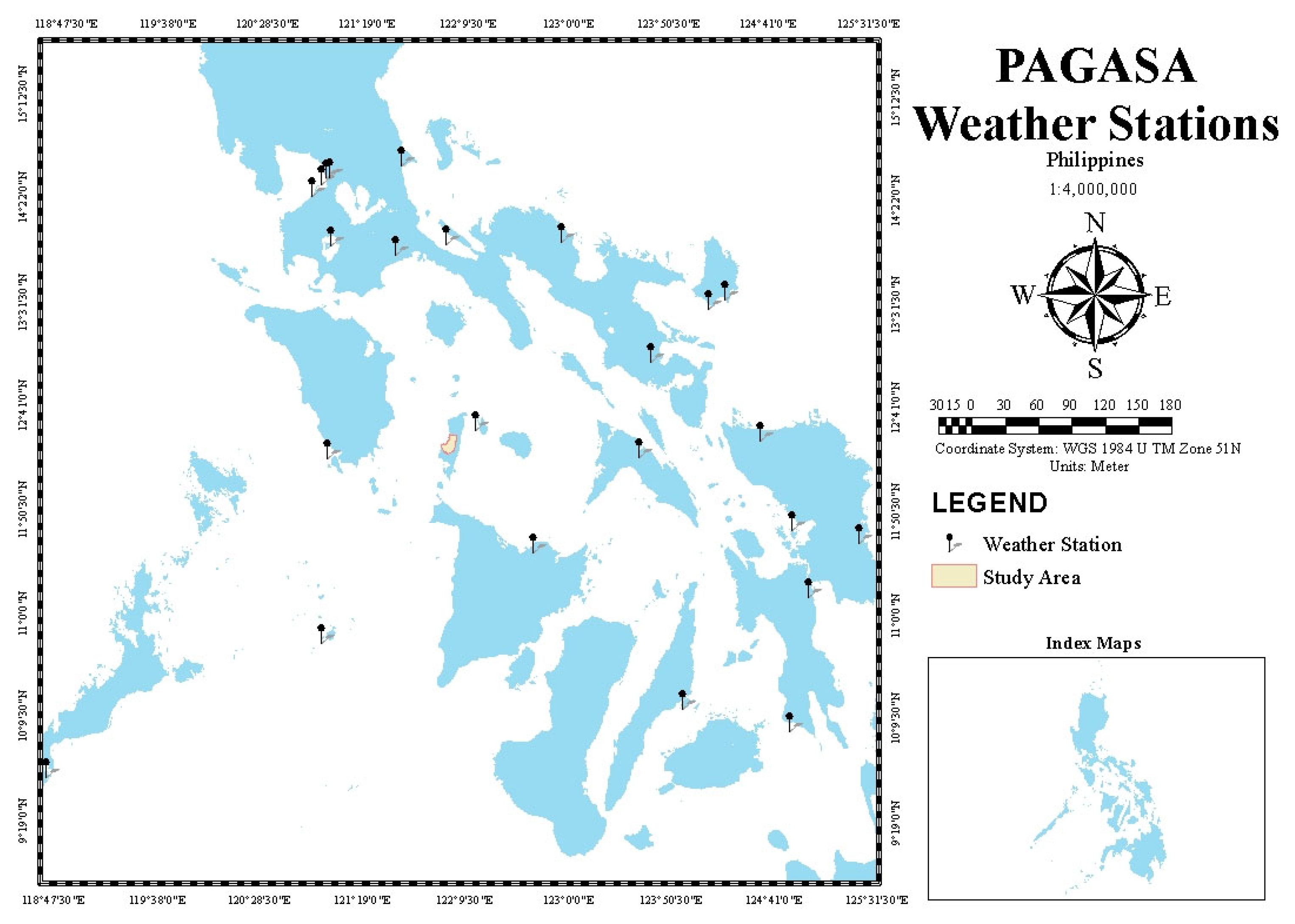
2.2. Data Collection and Identification of Factors
2.2.1. Flood Hazard Parameters
- Average Annual Rainfall
- 2.
- Slope
- 3.
- Elevation
- 4.
- Soil Type
- 5.
- Flood Depth
2.2.2. Flood Vulnerability Parameters
- Demographics
- 2.
- Disaster Risk Reduction Data
2.2.3. Flood Exposure Parameters
2.3. Modeling, GIS Mapping, and Validation
2.3.1. Basin Model Pre-Processing
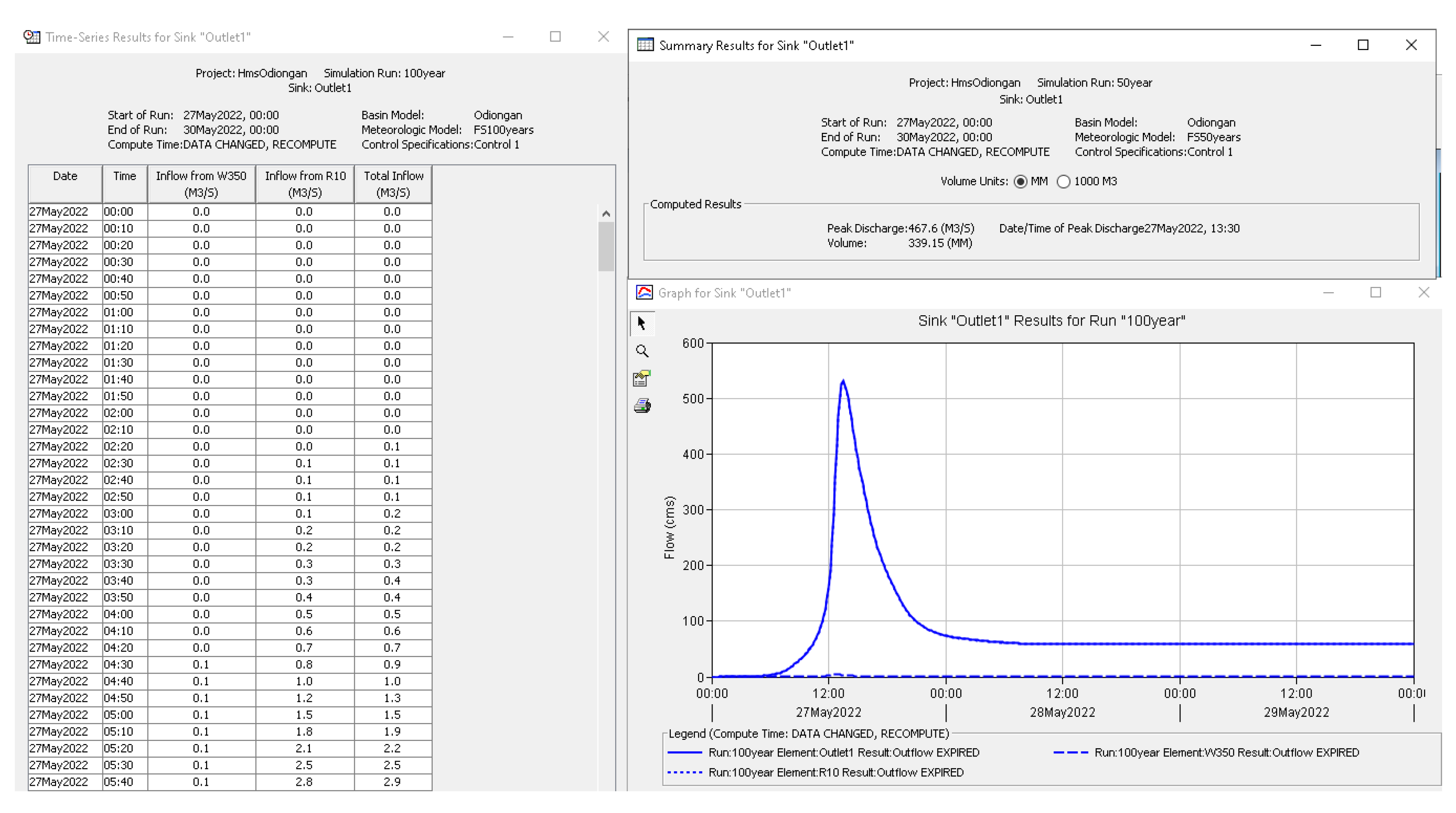
2.3.2. Basin Model Calibration and RIDF Simulations
2.3.3. Two-Dimensional (2D) RAS Model Simulations
2.4. Evaluation and Assessment of Parameters Using AHP
2.4.1. Determination of the Priorities among the Decision Elements of the Hierarchy
2.4.2. Derivation of the Overall Relative Weights
2.4.3. Verification of the Consistency of Judgments and Conclusions according to Results
2.5. Development of Flood Risk Map
3. Results
3.1. Data Analysis for Identified Parameter
3.1.1. Flood Hazard Parameters
3.1.2. Flood Vulnerability Parameters
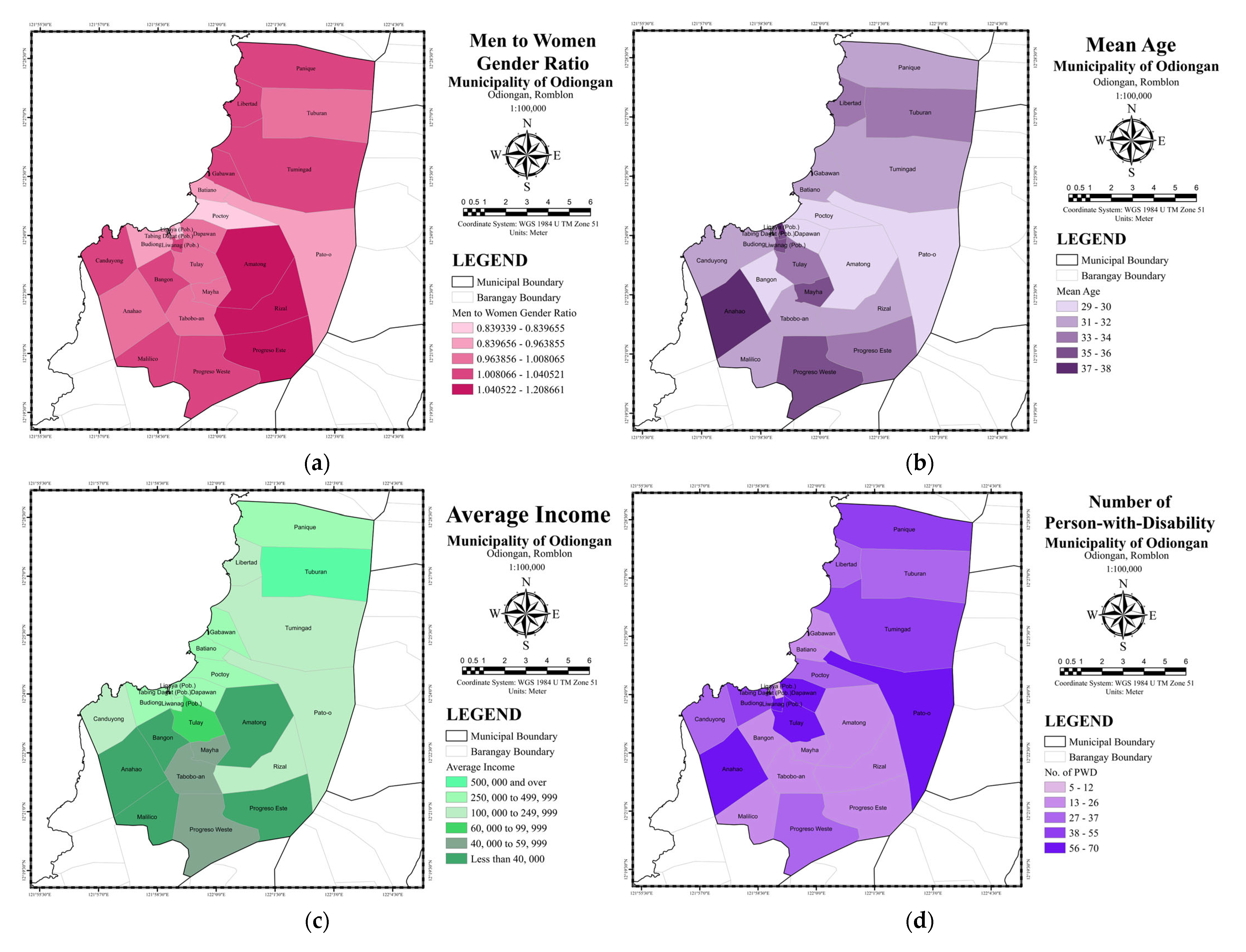
- The floods that hit the areas have disrupted public health and are a subject that has become increasingly important daily due to society’s reactions to hazards [55,56]. With a lack of health information, the study considered the number of PWD in each barangay. Under RA 10524, it refers to individuals who agonize long-term physical, mental, intellectual, or sensory impairments that may obstruct their full and practical involvement in society on an equal basis upon interaction with various barriers. The seven types of disabilities mentioned in RA No. 7277 are psychosocial disability, disability due to chronic illness, learning disability, mental disability, visual disability, orthopedic disability, and communication disability [56]. The number of PWD was based on the Barangay Management System (BMS). Records of the number of PWD in Odiongan, Romblon, as shown in Figure 7d, signify a risk in flood events or other natural disasters. The highest number of PWD are in Barangay Anahao, Pato-o, Tulay, and Dapawan, where Tulay and Dapawan experience flood events every year. However, many PWDs were observed in the southern and northern parts of the municipality, excluding barangay Anahao.
- The higher the level of education a respondent from a household has, the more likely the individual evacuates [57]. The data used in the study were based on a questionnaire survey conducted in each barangay. Only two categories recorded the highest educational attainment in Odiongan, Romblon, as shown in Figure 7e. More than half of the barangays indicate some high school graduate, and almost half were categorized as college graduates.
- 3.
- Type of Built-up Structures
3.1.3. Flood Exposure Parameters
3.2. Evaluation and Assessment of Parameters
3.3. Development of Flood Risk Map
4. Discussion
5. Conclusions
Author Contributions
Funding
Informed Consent Statement
Data Availability Statement
Acknowledgments
Conflicts of Interest
Appendix A


| Intensity of Importance | Definition | Description |
|---|---|---|
| 1 | Equally important | Two factors contribute equally to the objective |
| 3 | Moderately more important | Experience and judgment slightly favor one over the other |
| 5 | Strongly more important | Experience and judgment strongly favor one over the other |
| 7 | Very strong, more important | Experience and judgment very strongly favor one over the other. Its importance is demonstrated in practice. |
| 9 | Extremely more important | The evidence favoring one over the other is of the highest possible validity. |
| 2, 4, 6, 8 | Intermediate values | When compromise is needed. |
| Reciprocals of above | If an element i has one of the above numbers assigned to it when compared with element j, then j has the reciprocal value when compared with i | |
| Ratios (1.1–1.9) | If the activities (elements) are very close. | It may be challenging to assign the best value, but when compared with other contrasting activities (elements), the size of the small numbers would not be too noticeable, yet they can still indicate the relative importance of the activities (elements) |
| Indicators | Feature Class | Feature Weight |
|---|---|---|
| Flood Hazard Parameters | ||
| Average Annual Rainfall (in mm) | 2200 | 1 |
| 2210 | 1 | |
| 2220 | 2 | |
| 2230 | 3 | |
| 2240 | 4 | |
| 2250 | 5 | |
| Elevation (in meters) | 0–5 | 5 |
| 6–20 | 4 | |
| 21–50 | 3 | |
| 51–150 | 1 | |
| 151–600 | 0 | |
| Slope (in degrees) | 0–3 | 5 |
| 3–8 | 4 | |
| 8–18 | 3 | |
| 18–30 | 2 | |
| 30–50 | 1 | |
| 50 above | 0 | |
| Soil Type | Sandy, loamy sand, or sandy loam | 1 |
| Silt loam or loam | 3 | |
| Clay loam, silty clay loam, sandy clay, or clay | 5 | |
| Flood Depth (in meters) | 0–0.5 | 1 |
| 0.51–1 | 2 | |
| 1.01–1.5 | 3 | |
| 1.51–2 | 4 | |
| 2> | 5 | |
| Flood Vulnerability Parameters | ||
| Gender Ratio (men to women ratio) | 0.839339–0.839655 | 1 |
| 0.839656–0.963855 | 2 | |
| 0.963856–1.008065 | 3 | |
| 1.008066–1.040521 | 4 | |
| 1.040522–1.208661 | 5 | |
| Mean Age | 29–30 | 1 |
| 31–32 | 2 | |
| 33–34 | 3 | |
| 35–36 | 4 | |
| 37–38 | 5 | |
| Average Income | 500,000 and over | 1 |
| 250,000 to 499,999 | 1 | |
| 100,000 to 249,999 | 2 | |
| 60,000 to 99,999 | 3 | |
| 40,000 to 59,999 | 4 | |
| Less than 40,000 | 5 | |
| Number of PWD | 5–12 | 1 |
| 13–26 | 2 | |
| 27–37 | 3 | |
| 38–55 | 4 | |
| 56–70 | 5 | |
| Highest Educational Attainment | College Graduate | 3 |
| High School Graduate | 5 | |
| Water Usage | Ground | 4 |
| Piped | 5 | |
| Emergency Preparedness | Prepared | 5 |
| Well prepared | 4 | |
| Very well prepared | 3 | |
| Types of Build-up Structures | Permanent | 3 |
| Semi-permanent | 4 | |
| Temporary | 5 | |
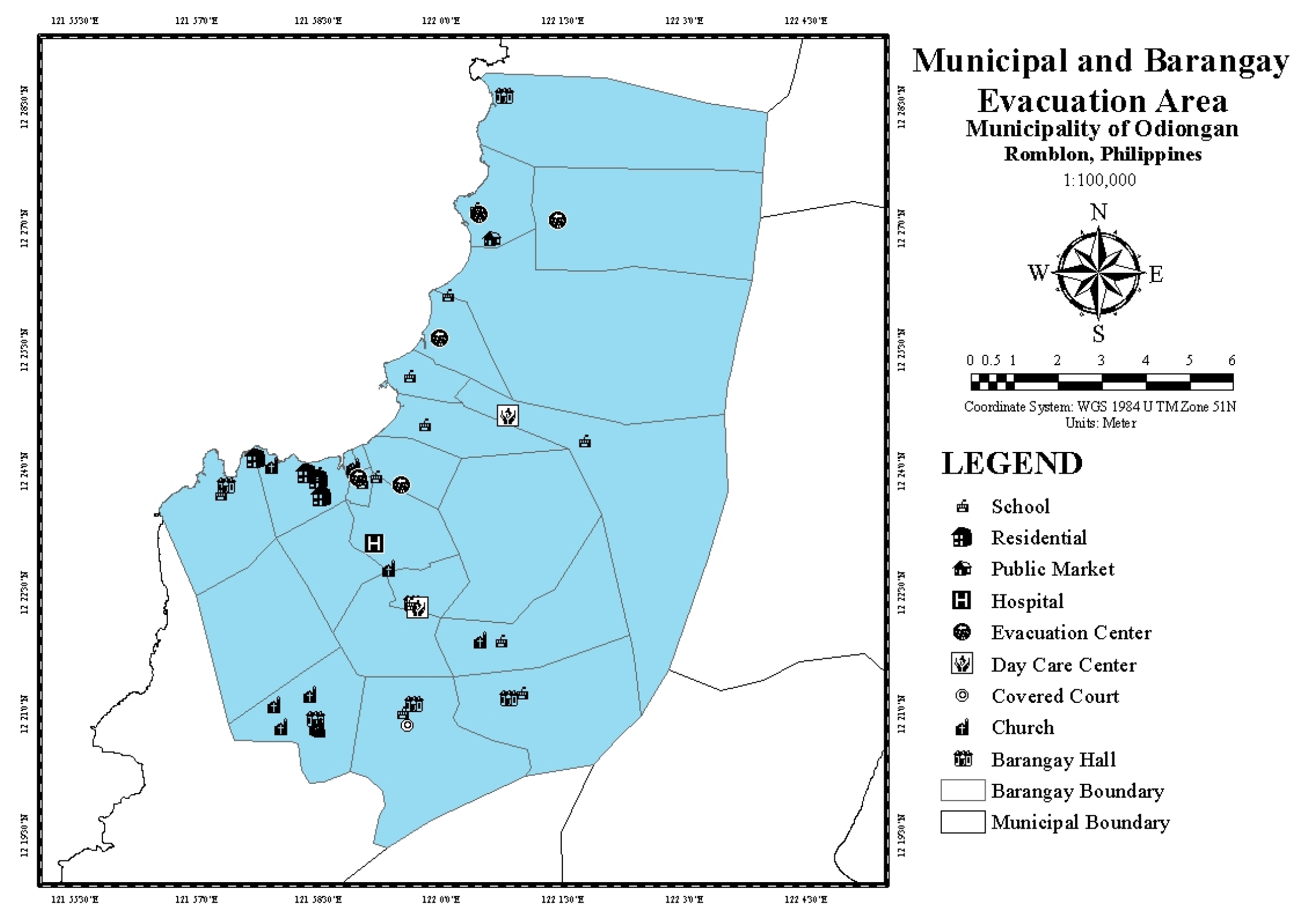
| Distance to the nearest Evacuation Area (in meters) | 2000 above | 5 |
| 2000 | 4 | |
| 1500 | 3 | |
| 1000 | 2 | |
| 500 | 1 | |
| Flood Exposure Parameters | ||
| Population Density | 7001–10,651 | 1 |
| 4001–7000 | 2 | |
| 2001–4000 | 3 | |
| 151–2000 | 4 | |
| 126–150 | 5 | |
| Land Use and Land Cover | Brushland | 1 |
| Built-up | 4 | |
| Cultivated Area | 3 | |
| Fishpond | 5 | |
| Grassland | 2 | |
| Mangrove | 0 | |
| Tree Plantation and Perennial | 0 | |
| Household Number | 172–250 | 1 |
| 251–350 | 2 | |
| 351–550 | 3 | |
| 551–650 | 4 | |
| 651–976 | 5 | |
| Respondent | Field of Expertise/Project Involvement | Agency/Institution/Project | Years in Service |
|---|---|---|---|
| 1 | Water Resource Engineering/Disaster Risk | Mapua University | 10 |
| 2 | Meteorology/Hydrology | PAGASA-DOST | 30 |
| 3 | Project Staff | FRAMER—Mapua University | 4 |
| 4 | Researcher | FRA Project—Asian Institute of Technology | 3 |
| 5 | Disaster Risk/Municipal Engineer | LGU—Odiongan | 30 |
| 6 | Meteorology/Hydrology | Visayas State University—Department of Meteorology | 8 |
| 7 | Meteorology/Hydrology | Central Luzon State University | 3 |
| 8 | Senior Research Specialist | UP Training Center for Applied Geodesy and Photogrammetry | 5 |
| 9 | Agriculturist II/Regional Head | Department of Agriculture—Bureau of Soil and Water Management | 3 |
| 10 | Supervising Geologist/Expert in Landslide and flood susceptibility mapping | Department of Environment and Natural Resources—Mines and Geosciences Bureau MIMAROPA | 15 |
References
- Osei, B.K.; Ahenkorah, I.; Ewusi, A.; Fiadonu, E.B. Assessment of flood prone zones in the Tarkwa mining area of Ghana using a GIS-based approach. Environ. Chall. 2021, 3, 100028. [Google Scholar] [CrossRef]
- Flood—UN-SPIDER Knowledge Portal. Available online: https://www.un-spider.org/category/disaster-type/flood (accessed on 7 September 2022).
- Nunez, C. Floods—Facts and Information. Available online: https://www.nationalgeographic.com/environment/article/floods (accessed on 27 June 2021).
- Malhotra, S. Flooded Cities and Millions Displaced in Pictures—Greenpeace International. Available online: https://www.greenpeace.org/international/story/44296/flooded-cities-and-millions-displaced-in-pictures/ (accessed on 27 June 2021).
- Monjardin, C.E.F.; Tan, F.J.; Uy, F.A.A.; Bale, F.J.P.; Voluntad, E.O.; Batac, R.M.N. Assessment of the existing drainage system in Infanta, Quezon province for flood hazard management using analytical hierarchy process. In Proceedings of the 2020 IEEE Conference on Technologies for Sustainability (SusTech), Santa Ana, CA, USA, 23–25 April 2020. [Google Scholar] [CrossRef]
- ESCAP IDD. Disasters in Asia and the Pacific: 2015 Year in Review; ESCAP IDD: Bangkok, Thailand, 2015. [Google Scholar]
- Davies, R. Philippines—Thousands Hit by More Floods in Central Regions—FloodList. Available online: http://floodlist.com/asia/philippines-negros-occidental-floods-january-2021 (accessed on 27 June 2021).
- Cabrera, J.S.; Lee, H.S. Flood risk assessment for Davao Oriental in the Philippines using geographic information system-based multi-criteria analysis and the maximum entropy model. J. Flood Risk Manag. 2020, 13, e12607. [Google Scholar] [CrossRef]
- Siddayao, G.P.; Valdez, S.E.; Fernandez, P.L. Analytic Hierarchy Process (AHP) in Spatial Modeling for Floodplain Risk Assessment. Int. J. Mach. Learn. Comput. 2014, 4, 450–457. [Google Scholar] [CrossRef]
- Teves, C. Romblon Waterways at Risk of Overflow due to ‘Quinta’ Rains—Philippine News Agency. Available online: https://www.pna.gov.ph/articles/1119823 (accessed on 27 June 2021).
- Alfonso, C.D.Q.; Sundo, M.B.; Zafra, R.G.; Velasco, P.P.; Aguirre, J.J.C.; Madlangbayan, M.S. Flood risk assessment of major river basins in the philippines. Int. J. GEOMATE 2019, 17, 201–208. [Google Scholar] [CrossRef]
- Rahman, M.Z.A.; Alkema, D. Digital surface model (DSM) construction and flood hazard simulation for Development Plans in Naga City, Philippines. GIS Dev. Malaysia 2006, 1–15. [Google Scholar]
- Ali, K.; Bajracharya, R.M.; Koirala, H.L. A Review of Flood Risk Assessment. Int. J. Environ. Agric. Biotechnol. 2016, 1, 1065–1077. [Google Scholar] [CrossRef]
- Pham, B.T.; Luu, C.; Phong, T.V.; Nguyen, H.D.; Le, H.V.; Tran, T.Q.; Ta, H.T.; Prakash, I. Flood risk assessment using hybrid artificial intelligence models integrated with multi-criteria decision analysis in Quang Nam Province, Vietnam. J. Hydrol. 2021, 592, 125815. [Google Scholar] [CrossRef]
- Cai, S.; Fan, J.; Yang, W. Flooding Risk Assessment and Analysis Based on GIS and the TFN-AHP Method: A Case Study of Chongqing, China. Atmosphere 2021, 12, 623. [Google Scholar] [CrossRef]
- Eleutério, J.; Martinez, D.; Rozan, A. Developing a GIS tool to assess potential damage of future floods. WIT Trans. Inf. Commun. Technol. 2010, 43, 381–392. [Google Scholar] [CrossRef]
- Noamen, B.; Taoufik, H.; Arfa, S.B. Flood risk assessment and mapping using multi-criteria analysis (AHP) model and GIS: Case of the Jendouba Governorate—Northwestern Tunisia. Int. J. Water Sci. Environ. Technol. 2020, 2, 139–149. [Google Scholar]
- Santillan, J.R.; Makinano-Santillan, M. Vertical accuracy assessment of 30-M resolution ALOS, ASTER, and SRTM global DEMS over Northeastern Mindanao, Philippines. Int. Arch. Photogramm. Remote Sens. Spat. Inf. Sci.—ISPRS Arch. 2016, 41, 149–156. [Google Scholar] [CrossRef]
- Chen, B.; Ge, Y. The building of network geographic information system based on ArcGIS. In Proceedings of the International Conference on Computer Application and System Modeling, Taiyuan, China, 22–24 October 2010; Volume 14, pp. 90–93. [Google Scholar] [CrossRef]
- Hawker, L.; Bates, P.; Neal, J.; Rougier, J. Perspectives on Digital Elevation Model (DEM) Simulation for Flood Modeling in the Absence of a High-Accuracy Open Access Global DEM. Front. Earth Sci. 2018, 6, 3389. [Google Scholar] [CrossRef]
- Jeon, Y.W.; Bae, Y.; Ra, J.B. Error detection in digital elevation model using a camera image. In Proceedings of the International Geoscience and Remote Sensing Symposium, Melbourne, VIC, Australia, 21–26 July 2013; pp. 2517–2519. [Google Scholar] [CrossRef]
- Sugumaran, R.; Davis, C.H.; Meyer, J.; Prato, T. High resolution digital elevation model and a web-based client-server application for improved flood plain management. In Proceedings of the International Geoscience and Remote Sensing Symposium, Honolulu, HI, USA, 24–28 July 2000; Volume 1, pp. 334–335. [Google Scholar] [CrossRef]
- Ballado, A.H.; Bentir, S.A.P.; Lazaro, J.B.; Macawile, M.J.P. Depth perception analysis of LiDAR digital elevation model for low lying areas using delaunay triangulation algorithm. In Proceedings of the HNICEM 2017—9th International Conference on Humanoid, Nanotechnology, Information Technology, Communication and Control, Environment and Management, Manila, Philippines, 1–3 December 2017; pp. 1–5. [Google Scholar] [CrossRef]
- Ternate, J.R.; Celeste, M.I.; Pineda, E.F.; Tan, F.J.; Uy, F.A.A. Floodplain Modelling of Malaking-Ilog River in Southern Luzon, Philippines Using LiDAR Digital Elevation Model for the Design of Water-Related Structures. IOP Conf. Ser. Mater. Sci. Eng. 2017, 216, 012044. [Google Scholar] [CrossRef]
- Lagmay, A.M.F.A.; Racoma, B.A.; Aracan, K.A.; Alconis-Ayco, J.; Saddi, I.L. Disseminating near-real-time hazards information and flood maps in the Philippines through Web-GIS. J. Environ. Sci. 2017, 59, 13–23. [Google Scholar] [CrossRef] [PubMed]
- Kittipongvises, S.; Phetrak, A.; Rattanapun, P.; Brundiers, K.; Buizer, J.L.; Melnick, R. AHP-GIS analysis for flood hazard assessment of the communities nearby the world heritage site on Ayutthaya Island, Thailand. Int. J. Disaster Risk Reduct. 2020, 48, 101612. [Google Scholar] [CrossRef]
- Abe, Y.; Zodrow, I.; Johnson, D.A.K.; Silerio, L. Risk informed and resilient development: Engaging the private sector in the era of the Sendai Framework. Prog. Disaster Sci. 2019, 2, 100020. [Google Scholar] [CrossRef]
- Wilkins, A.; Pennaz, A.; Dix, M.; Smith, A.; Vawter, J.; Karlson, D.; Tokar, S.; Brooks, E. Challenges and opportunities for Sendai framework disaster loss reporting in the United States. Prog. Disaster Sci. 2021, 10, 100167. [Google Scholar] [CrossRef]
- Danumah, J.H.; Odai, S.N.; Saley, B.M.; Szarzynski, J.; Thiel, M.; Kwaku, A.; Kouame, F.K.; Akpa, L.Y. Flood risk assessment and mapping in Abidjan district using multi-criteria analysis (AHP) model and geoinformation techniques, (cote d’ivoire). Geoenviron. Disasters 2016, 3, 10. [Google Scholar] [CrossRef]
- Boroushaki, S.; Malczewski, J. Using the fuzzy majority approach for GIS-based multicriteria group decision-making. Comput. Geosci. 2010, 36, 302–312. [Google Scholar] [CrossRef]
- Dodgson, J.S.; Spackman, M.; Pearman, A.; Phillips, L.D. Multi-Criteria Analysis: A Manual; Department for Communities and Local Government: London, UK, 2009; Volume 11, pp. 1–16. ISBN 978-1-4098-1023-0. [Google Scholar]
- Ouma, Y.O.; Tateishi, R. Urban flood vulnerability and risk mapping using integrated multi-parametric AHP and GIS: Methodological overview and case study assessment. Water 2014, 6, 1515–1545. [Google Scholar] [CrossRef]
- Juneja, P. What Is Analytical Hierarchy Process (AHP) and How to Use It? Available online: https://www.managementstudyguide.com/analytical-hierarchy-process.htm (accessed on 30 June 2021).
- Siddayao, G.P.; Valdez, S.E.; Fernandez, P.L. Modeling Flood Risk for an Urban CBD Using AHP and GIS. Int. J. Inf. Educ. Technol. 2015, 5, 748–753. [Google Scholar] [CrossRef]
- Rahadianto, H.; Fariza, A.; Hasim, J.A.N. Risk-level assessment system on Bengawan Solo River basin flood prone areas using analytic hierarchy process and natural breaks: Study case: East Java. In Proceedings of the 2015 International Conference on Data and Software Engineering, ICODSE 2015, Yogyakarta, Indonesia, 25–26 November 2015; pp. 195–200. [Google Scholar] [CrossRef]
- Lyu, H.M.; Zhou, W.H.; Shen, S.L.; Zhou, A.N. Inundation risk assessment of metro system using AHP and TFN-AHP in Shenzhen. Sustain. Cities Soc. 2020, 56, 102103. [Google Scholar] [CrossRef]
- Weerasinghe, K.M.; Gehrels, H.; Arambepola, N.M.S.I.; Vajja, H.P.; Herath, J.M.K.; Atapattu, K.B. Qualitative Flood Risk assessment for the Western Province of Sri Lanka. Procedia Eng. 2018, 212, 503–510. [Google Scholar] [CrossRef]
- Seejata, K.; Yodying, A.; Wongthadam, T.; Mahavik, N.; Tantanee, S. Assessment of flood hazard areas using Analytical Hierarchy Process over the Lower Yom Basin, Sukhothai Province. Procedia Eng. 2018, 212, 340–347. [Google Scholar] [CrossRef]
- Cabrera, J.S.; Lee, H.S. Impacts of climate change on flood-prone areas in Davao Oriental, Philippines. Water 2018, 10, 893. [Google Scholar] [CrossRef]
- Lim, M.B.B.; Lim, H.R.; Piantanakulchai, M. Flood evacuation decision modeling for high risk urban area in the Philippines. Asia Pac. Manag. Rev. 2019, 24, 106–113. [Google Scholar] [CrossRef]
- Cai, T.; Li, X.; Ding, X.; Wang, J.; Zhan, J. Flood risk assessment based on hydrodynamic model and fuzzy comprehensive evaluation with GIS technique. Int. J. Disaster Risk Reduct. 2019, 35, 101077. [Google Scholar] [CrossRef]
- Robielos, R.A.C.; Lin, C.J.; Senoro, D.B.; Ney, F.P. Development of vulnerability assessment framework for disaster risk reduction at three levels of geopolitical units in the Philippines. Sustainability 2020, 12, 8815. [Google Scholar] [CrossRef]
- Prasetyo, Y.T.; Senoro, D.B.; German, J.D.; Robielos, R.A.C.; Ney, F.P. Confirmatory factor analysis of vulnerability to natural hazards: A household Vulnerability Assessment in Marinduque Island, Philippines. Int. J. Disaster Risk Reduct. 2020, 50, 101831. [Google Scholar] [CrossRef]
- Chen, Y.R.; Yeh, C.H.; Yu, B. Integrated application of the analytic hierarchy process and the geographic information system for flood risk assessment and flood plain management in Taiwan. Nat. Hazards 2011, 59, 1261–1276. [Google Scholar] [CrossRef]
- Gigović, L.; Pamučar, D.; Bajić, Z.; Drobnjak, S. Application of GIS-interval rough AHP methodology for flood hazard mapping in Urban areas. Water 2017, 9, 360. [Google Scholar] [CrossRef]
- Cabrera, J.S.; Lee, H.S. Flood-prone area assessment using GIS-based multi-criteria analysis: A case study in Davao Oriental, Philippines. Water 2019, 11, 2203. [Google Scholar] [CrossRef]
- PAGASA. Climatological Normals. Available online: https://www.pagasa.dost.gov.ph/climate/climatological-normals (accessed on 10 September 2022).
- LGU Odiongan. Comprehensive Land Use Plan (CLUP); LGU Odiongan: Romblon, Philippines, 2017. [Google Scholar]
- HEC-HMS. Available online: https://www.hec.usace.army.mil/software/hec-hms/ (accessed on 10 September 2022).
- HEC-RAS. Available online: https://www.hec.usace.army.mil/software/hec-ras/ (accessed on 10 September 2022).
- GEOHAZARD MAPS. Available online: https://region4b.mgb.gov.ph/28-geohazard-maps/98-geohazard-maps#romblon-2 (accessed on 10 September 2022).
- Kokangül, A.; Polat, U.; Dağsuyu, C. A new approximation for risk assessment using the AHP and Fine Kinney methodologies. Saf. Sci. 2017, 91, 24–32. [Google Scholar] [CrossRef]
- Employment of PWDs. Available online: https://www.pwc.com/ph/en/taxwise-or-otherwise/2017/employment-of-pwds.html (accessed on 2 June 2022).
- Febrianto, H.; Fariza, A.; Hasim, J.A.N. Urban flood risk mapping using analytic hierarchy process and natural break classification (Case study: Surabaya, East Java, Indonesia). In Proceedings of the 2016 International Conference on Knowledge Creation and Intelligent Computing, KCIC 2016, Manado, Indonesia, 15–17 November 2016; pp. 148–154. [Google Scholar] [CrossRef]
- National Disaster Management Office (NDMO). Republic of Vanuatu National Guidelines for the Selection and Assessment of Evacuation Centres; National Disaster Management Office: Port Vila, Vanatu, 2016.
- Engay-Gutierrez, K.G. Land cover change in the silang-santa rosa river subwatershed, Laguna, Philippines. J. Environ. Sci. Manag. 2015, 18, 34–46. [Google Scholar] [CrossRef]
- Stefanidis, S.; Stathis, D. Assessment of flood hazard based on natural and anthropogenic factors using analytic hierarchy process (AHP). Nat. Hazards 2013, 68, 569–585. [Google Scholar] [CrossRef]
- Shrestha, B.B.; Okazumi, T.; Miyamoto, M.; Sawano, H. Development of flood risk assessment method for data-poor river basins: A case study in the Pampanga River Basin, Philippines. In Proceedings of the 6th International Conference on Flood Management, Sao Paolo, Brazil, 16–18 September 2014; Volume ii, pp. 1–12. [Google Scholar]
- Shrestha, B.B.; Sawano, H.; Ohara, M.; Nagumo, N. Improvement in flood disaster damage assessment using highly accurate IfSAR DEM. J. Disaster Res. 2016, 11, 1137–1149. [Google Scholar] [CrossRef]
- Lyu, H.M.; Sun, W.J.; Shen, S.L.; Arulrajah, A. Flood risk assessment in metro systems of mega-cities using a GIS-based modeling approach. Sci. Total Environ. 2018, 626, 1012–1025. [Google Scholar] [CrossRef]
- Bera, R.; Maiti, R. Multi hazards risk assessment of Indian Sundarbans using GIS based Analytic Hierarchy Process (AHP). Reg. Stud. Mar. Sci. 2021, 44, 101766. [Google Scholar] [CrossRef]
- Puno, G.R.; Amper, R.A.L.; Talisay, B.A.M. Flood simulation using geospatial models in Manupali Watershed, Bukidnon, Philippines. J. Biodivers. Environ. Sci. 2018, 12, 294–303. [Google Scholar]
- Kia, M.B.; Pirasteh, S.; Pradhan, B.; Mahmud, A.R.; Sulaiman, W.N.A.; Moradi, A. An artificial neural network model for flood simulation using GIS: Johor River Basin, Malaysia. Environ. Earth Sci. 2012, 67, 251–264. [Google Scholar] [CrossRef]
- Talisay, B.A.M.; Puno, G.R.; Amper, R.A.L. Flood hazard mapping in an urban area using combined hydrologic-hydraulic models and geospatial technologies. Glob. J. Environ. Sci. Manag. 2019, 5, 139–154. [Google Scholar] [CrossRef]
- Pornasdoro, K.P.; Silva, L.C.; Munárriz, M.L.T.; Estepa, B.A.; Capaque, C.A. Flood Risk of Metro Manila Barangays: A GIS Based Risk Assessment Using Multi-Criteria Techniques. J. Urban Reg. Plan. 2014, 1, 51–72. [Google Scholar]
- Clark, C. Flood risk assessment. Int. Water Power Dam Constr. 2007, 59, 1–25. [Google Scholar] [CrossRef]
- Åström, H.L.A. An Urban Flood Risk Assessment Method Using the Bayesian Network Approach; DTU Environment, Technical University of Denmark: Lyngby, Denmark, 2015. [Google Scholar]
- Feloni, E.; Mousadis, I.; Baltas, E. Flood vulnerability assessment using a GIS-based multi-criteria approach—The case of Attica region. J. Flood Risk Manag. 2020, 13, e12563. [Google Scholar] [CrossRef]
- Tehrany, M.S.; Pradhan, B.; Jebur, M.N. Spatial prediction of flood susceptible areas using rule based decision tree (DT) and a novel ensemble bivariate and multivariate statistical models in GIS. J. Hydrol. 2013, 504, 69–79. [Google Scholar] [CrossRef]
- Monjardin, C.E.F.; Senoro, D.B.; Magbanlac, J.J.M.; de Jesus, K.L.M.; Tabelin, C.B.; Natal, P.M. Geo-Accumulation Index of Manganese in Soils Due to Flooding in Boac and Mogpog Rivers, Marinduque, Philippines with Mining Disaster Exposure. Appl. Sci. 2022, 12, 3527. [Google Scholar] [CrossRef]


| References | Parameter | Data Type | Duration/Year | Source |
|---|---|---|---|---|
| Flood Hazard Parameters | ||||
| [8,17,35,39,40,41] | Average Annual Rainfall | Interpolated Climatological Normal using Isohyetal Method | 2020 | PAGASA and web search for weather station coordinates |
| [8,17,26,32,35,41] | Slope | Derived from IfSAR Data using Slope Tool in ArcMap | 2013 | (NAMRIA-DENR) |
| [6,8,26,32,35,41] | Elevation | Derived from IfSAR Data using Field Contour Tool in ArcMap | 2013 | (NAMRIA-DENR) |
| [8,9,17,42] | Soil Type | Shapefile from the archive of CLUP | 2011 | Municipality of Odiongan, Romblon—(CLUP) |
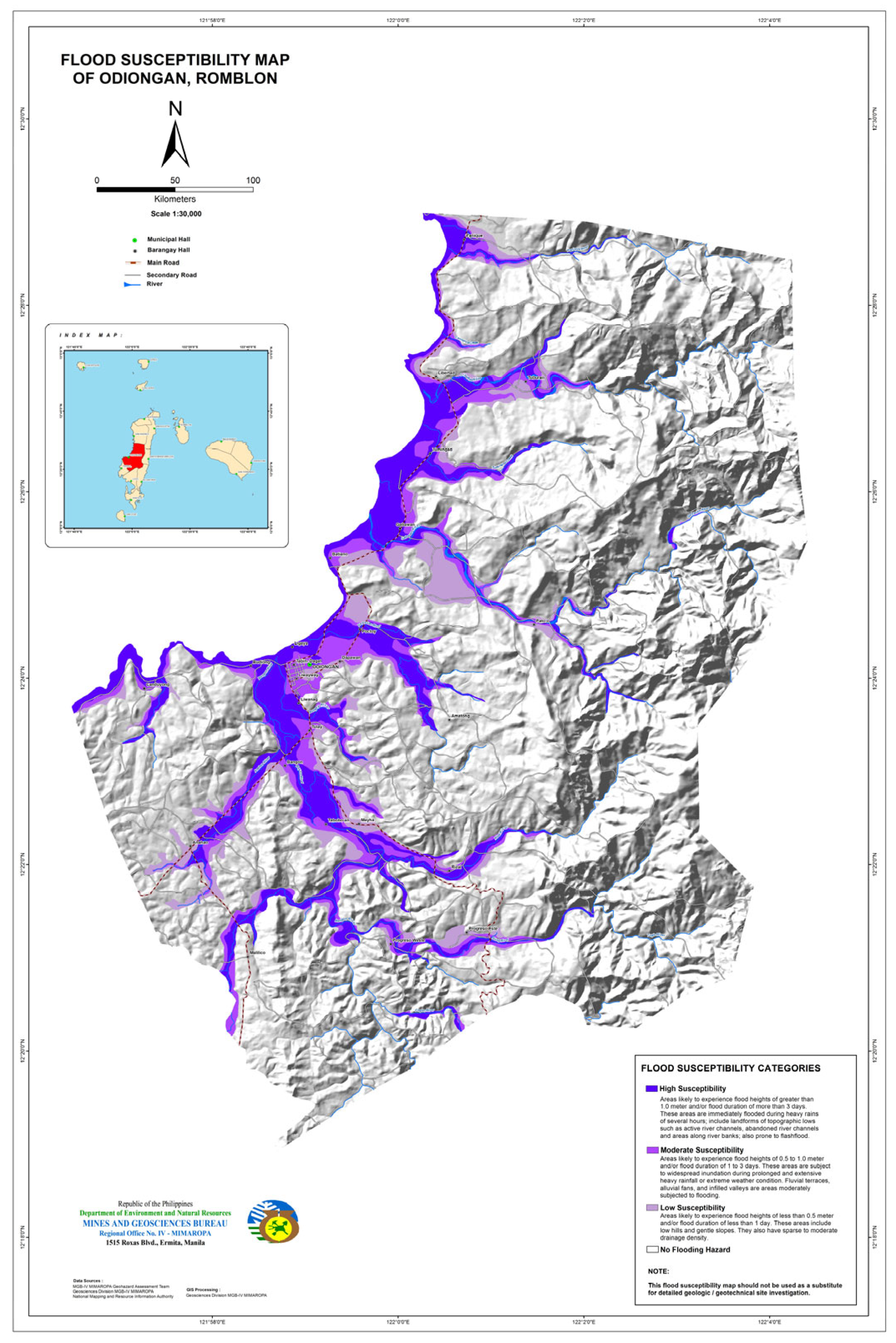
| [37,43,44,45] | Flood Depth | 100-year period of flood model simulated in HEC-HMS and HEC-RAS and MGB Flood Susceptibility Map | 2018 | MGB |
| Flood Vulnerability Parameters | ||||
| [39,43] | Gender Ratio | Men to women gender ratio | 2020 | Barangay Profile |
| [43] | Average Age | Mean age of the individual | 2020 | Barangay Profile |
| [43,31] | Average Income | Annual average income per household | 2020 | Barangay Profile |
| [39,46] | Number of Persons with Disabilities | Number of PWD in barangay | 2022 | Barangay Management System (BMS) |
| [43,46] | Highest Educational Attainment | Average educational attainment of individuals in barangay | 2020 | Barangay Profile |
| [46,47,48] | Water Usage | Primary source of water | 2022 | Survey Questionnaire |
| Emergency Preparedness | Emergency preparedness during unexpected situations like natural disasters | 2022 | Survey Questionnaire | |
| [29] | Types of Built-up Structures | Classification of structures of every household | 2020 | Barangay Profile |
| Distance from the nearest Evacuation Area | Distance of identified evacuation area using buffer tool in Arcmap | 2022 | Site Investigation and Survey Questionnaire | |
| Flood Exposure Parameters | ||||
| [9,29,40,42,49] | Population Density | Computed from the population over the covered area of the barangay | 2020 | PSA |
| [43] | Household Number | Number of households of every barangay | 2020 | PSA |
| [6,17,26,35,40,41] | Land Use/Land Cover | Land cover map from CLUP | 2011 | Municipality of Odiongan, Romblon—(CLUP) |
| AAR | E | S | ST | FD | Weights | Percentage Weights | |
|---|---|---|---|---|---|---|---|
| AAR | 0.224979 | 0.221826 | 0.259802 | 0.194982 | 0.228034 | 0.225925 | 23% |
| E | 0.208256 | 0.205338 | 0.197392 | 0.202930 | 0.208920 | 0.204567 | 20% |
| S | 0.154522 | 0.185622 | 0.178439 | 0.193329 | 0.188299 | 0.180042 | 18% |
| ST | 0.196749 | 0.172539 | 0.157384 | 0.170516 | 0.156328 | 0.170703 | 17% |
| FD | 0.215493 | 0.214675 | 0.206983 | 0.238243 | 0.21842 | 0.218763 | 22% |
| 100% |
| GR | MA | AI | NPWD | HEA | WU | EP | TBS | DEA | Weights | Percentage Weights | |
|---|---|---|---|---|---|---|---|---|---|---|---|
| GR | 0.091812 | 0.072630 | 0.083258 | 0.095499 | 0.093304 | 0.088862 | 0.116943 | 0.095699 | 0.080989 | 0.091000 | 9% |
| MA | 0.136601 | 0.108062 | 0.134171 | 0.116910 | 0.076277 | 0.083485 | 0.110578 | 0.090066 | 0.125462 | 0.109068 | 11% |
| AI | 0.124171 | 0.090691 | 0.112602 | 0.090232 | 0.105573 | 0.129437 | 0.126444 | 0.135126 | 0.096882 | 0.112351 | 11% |
| NPWD | 0.101895 | 0.097966 | 0.132265 | 0.105988 | 0.102919 | 0.107756 | 0.086492 | 0.107974 | 0.106007 | 0.105474 | 11% |
| HEA | 0.078704 | 0.113313 | 0.085309 | 0.082368 | 0.079983 | 0.095524 | 0.073935 | 0.096588 | 0.092532 | 0.088695 | 9% |
| WU | 0.109121 | 0.136708 | 0.091879 | 0.103882 | 0.088433 | 0.105616 | 0.085829 | 0.111776 | 0.117633 | 0.105653 | 11% |
| EP | 0.108148 | 0.134616 | 0.122671 | 0.168801 | 0.149019 | 0.169508 | 0.137751 | 0.134197 | 0.130969 | 0.139520 | 14% |
| TBS | 0.114932 | 0.143735 | 0.099830 | 0.117594 | 0.099203 | 0.113196 | 0.122971 | 0.119798 | 0.130779 | 0.118004 | 12% |
| DEA | 0.134616 | 0.102279 | 0.138016 | 0.118726 | 0.205288 | 0.106616 | 0.139056 | 0.108777 | 0.118748 | 0.130236 | 13% |
| 100% |
| PD | LC | NH | Weights | Percentage Weights | |
|---|---|---|---|---|---|
| PD | 0.326245 | 1/3 | 1/3 | 0.327369 | 33% |
| LC | 0.37159 | 0.34364 | 0.31783 | 0.344357 | 34% |
| NH | 0.302161 | 0.354651 | 0.328012 | 0.328274 | 33% |
| 100% |
| AAR | E | S | ST | FD | Sum | Crit. Weigths | |
|---|---|---|---|---|---|---|---|
| AAR | 0.225925 | 0.244066 | 0.328938 | 0.258341 | 0.235870 | 1.293139 | 5.72376382 |
| E | 0.189362 | 0.204567 | 0.226295 | 0.243454 | 0.195670 | 1.059347 | 5.17847996 |
| S | 0.123658 | 0.162756 | 0.180042 | 0.204129 | 0.155214 | 0.825800 | 4.58669759 |
| ST | 0.149284 | 0.143437 | 0.150561 | 0.170703 | 0.122176 | 0.736161 | 4.31251769 |
| FD | 0.209539 | 0.228710 | 0.253757 | 0.305653 | 0.218763 | 1.216422 | 5.56046026 |
| ymax | 5.07238386 | ||||||
| CI | 0.018095966 | ||||||
| CR | 0.016157112 |
| GR | MA | AI | NPWD | HEA | WU | EP | TBS | DEA | Sum | Crit. Weights | |
|---|---|---|---|---|---|---|---|---|---|---|---|
| GR | 0.091000 | 0.061162 | 0.067285 | 0.081994 | 0.106155 | 0.076564 | 0.077254 | 0.072694 | 0.062064 | 0.696171 | 7.650275 |
| MA | 0.162276 | 0.109068 | 0.129960 | 0.120308 | 0.104014 | 0.086214 | 0.087554 | 0.081999 | 0.115235 | 0.996628 | 9.137668 |
| AI | 0.151949 | 0.094290 | 0.112351 | 0.095649 | 0.148296 | 0.137692 | 0.103129 | 0.126726 | 0.091663 | 1.061744 | 9.450256 |
| NPWD | 0.117057 | 0.095620 | 0.123891 | 0.105474 | 0.135719 | 0.107612 | 0.066225 | 0.095063 | 0.094157 | 0.940818 | 8.919941 |
| HEA | 0.076032 | 0.093005 | 0.067196 | 0.068929 | 0.088695 | 0.080220 | 0.047605 | 0.071511 | 0.069114 | 0.662308 | 7.467245 |
| WU | 0.125572 | 0.133660 | 0.086208 | 0.103554 | 0.116815 | 0.105653 | 0.065829 | 0.098578 | 0.104661 | 0.940530 | 8.902074 |
| EP | 0.164345 | 0.173804 | 0.151996 | 0.222206 | 0.259944 | 0.223923 | 0.139520 | 0.156289 | 0.153880 | 1.645906 | 11.79692 |
| TBS | 0.147721 | 0.156959 | 0.104619 | 0.130927 | 0.146361 | 0.126474 | 0.105343 | 0.118004 | 0.129960 | 1.166368 | 9.884114 |
| DEA | 0.190954 | 0.123266 | 0.159630 | 0.145889 | 0.334267 | 0.131470 | 0.131470 | 0.118254 | 0.130236 | 1.465436 | 11.25217 |
| ymax | 9.384519 | ||||||||||
| CI | 0.048065 | ||||||||||
| CR | 0.033148 |
| PD | LC | NH | Sum | Crit. Weights | |
|---|---|---|---|---|---|
| PD | 0.327369 | 0.287416 | 0.353462 | 0.968247 | 2.957665 |
| LC | 0.392224 | 0.344357 | 0.33367 | 1.070251 | 3.10797 |
| NH | 0.30404 | 0.338789 | 0.328274 | 0.971104 | 2.958207 |
| ymax | 3.007947 | ||||
| CI | 0.003974 | ||||
| CR | 0.006851 |
| Parameters | Weights | Percentage Weights |
|---|---|---|
| Hazard Parameters | ||
| Average Annual Rainfall (AAR) | 0.225925 | 22.59% |
| Elevation (E) | 0.204567 | 20.46% |
| Slope (S) | 0.180042 | 18.0% |
| Soil Type (ST) | 0.170703 | 17.07% |
| Flood Depth (FD) | 0.218763 | 21.88% |
| Vulnerability Parameters | ||
| Gender Ratio (GR) | 0.091000 | 9.1% |
| Mean Age (MA) | 0.109068 | 10.91% |
| Average Income (AI) | 0.112351 | 11.24% |
| Number of PWD (NPWD) | 0.105474 | 10.55% |
| Highest Educational Attainment (HEA) | 0.088695 | 8.87% |
| Water Usage (WU) | 0.105653 | 10.57% |
| Emergency Preparedness (EP) | 0.139520 | 13.95% |
| Types of Build-up Structures (TBS) | 0.118004 | 11.8% |
| Distance to the nearest Evacuation Area (DEA) | 0.130236 | 13.02% |
| Exposure Parameters | ||
| Population Density (PD) | 0.327369 | 32.74% |
| Land Use/Land Cover (LULC) | 0.344357 | 34.44% |
| Household Number (HN) | 0.328274 | 32.83% |
Publisher’s Note: MDPI stays neutral with regard to jurisdictional claims in published maps and institutional affiliations. |
© 2022 by the authors. Licensee MDPI, Basel, Switzerland. This article is an open access article distributed under the terms and conditions of the Creative Commons Attribution (CC BY) license (https://creativecommons.org/licenses/by/4.0/).
Share and Cite
Gacu, J.G.; Monjardin, C.E.F.; Senoro, D.B.; Tan, F.J. Flood Risk Assessment Using GIS-Based Analytical Hierarchy Process in the Municipality of Odiongan, Romblon, Philippines. Appl. Sci. 2022, 12, 9456. https://doi.org/10.3390/app12199456
Gacu JG, Monjardin CEF, Senoro DB, Tan FJ. Flood Risk Assessment Using GIS-Based Analytical Hierarchy Process in the Municipality of Odiongan, Romblon, Philippines. Applied Sciences. 2022; 12(19):9456. https://doi.org/10.3390/app12199456
Chicago/Turabian StyleGacu, Jerome G., Cris Edward F. Monjardin, Delia B. Senoro, and Fibor J. Tan. 2022. "Flood Risk Assessment Using GIS-Based Analytical Hierarchy Process in the Municipality of Odiongan, Romblon, Philippines" Applied Sciences 12, no. 19: 9456. https://doi.org/10.3390/app12199456
APA StyleGacu, J. G., Monjardin, C. E. F., Senoro, D. B., & Tan, F. J. (2022). Flood Risk Assessment Using GIS-Based Analytical Hierarchy Process in the Municipality of Odiongan, Romblon, Philippines. Applied Sciences, 12(19), 9456. https://doi.org/10.3390/app12199456