Integrating Airborne Laser Scanning and 3D Ground-Penetrating Radar for the Investigation of Protohistoric Structures in Croatian Istria
 ,
,  ,
,
Abstract
1. Introduction
2. Geographic, Geological and Archaeological Background
3. Materials and Methods
3.1. Airborne Laser Scanning
3.2. 3D Ground Penetrating Radar
3.3. ALS-GPR Integration
4. Results
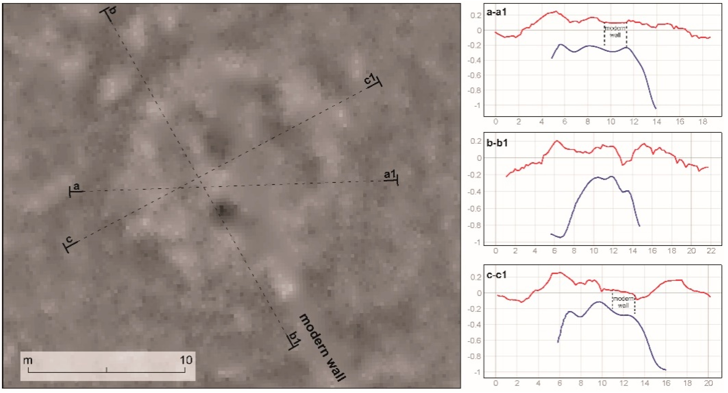
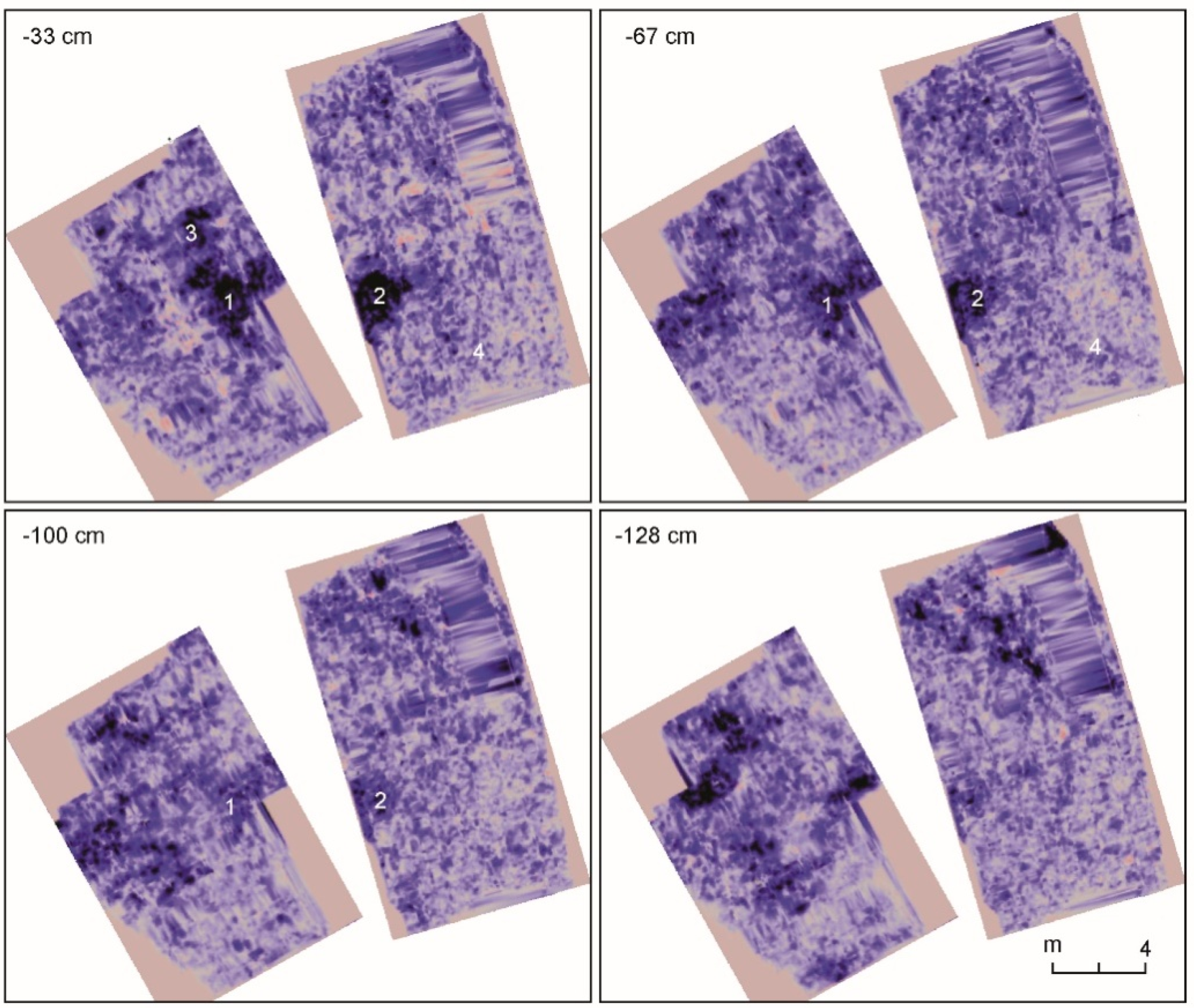
4.1. Feature 8
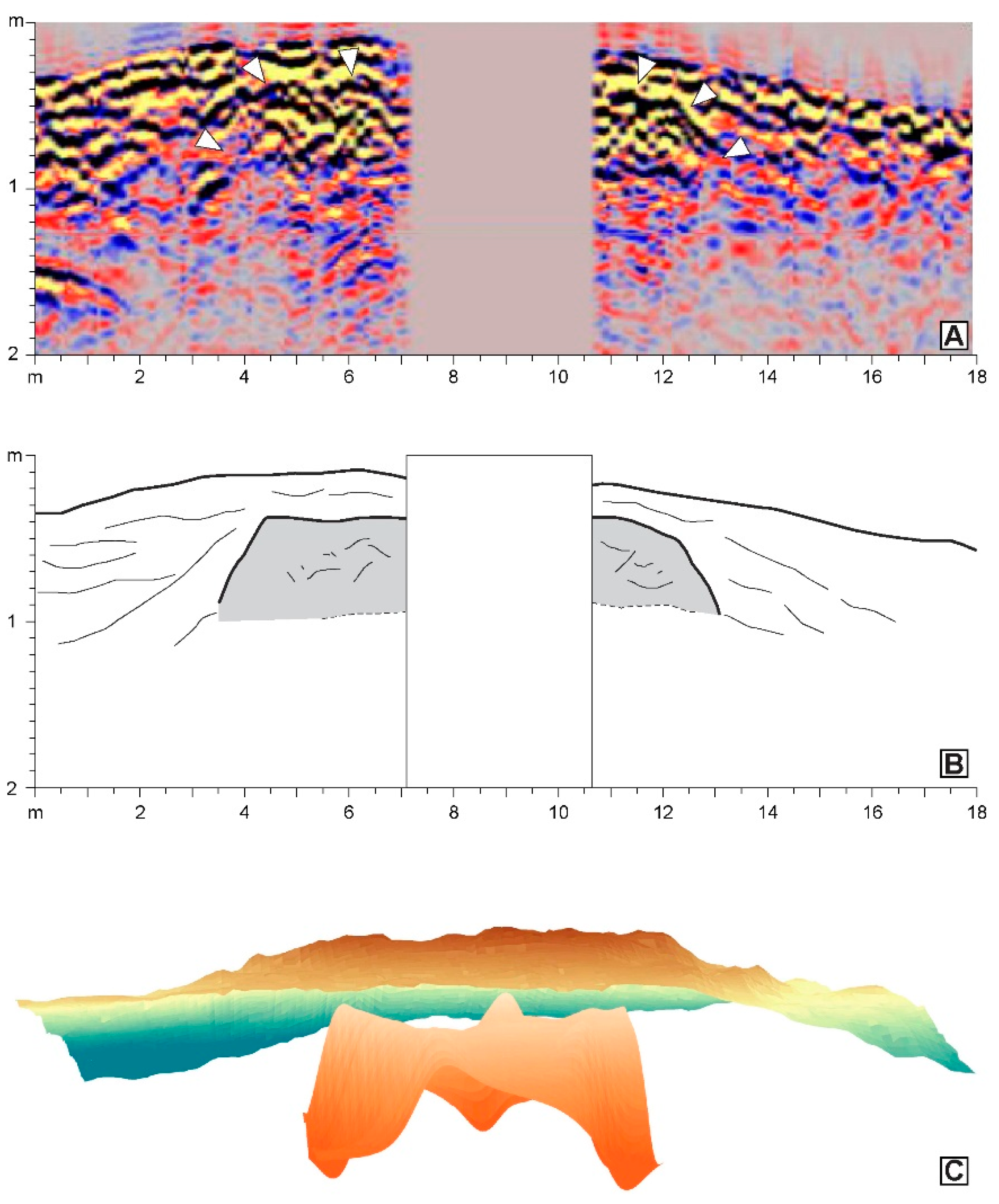
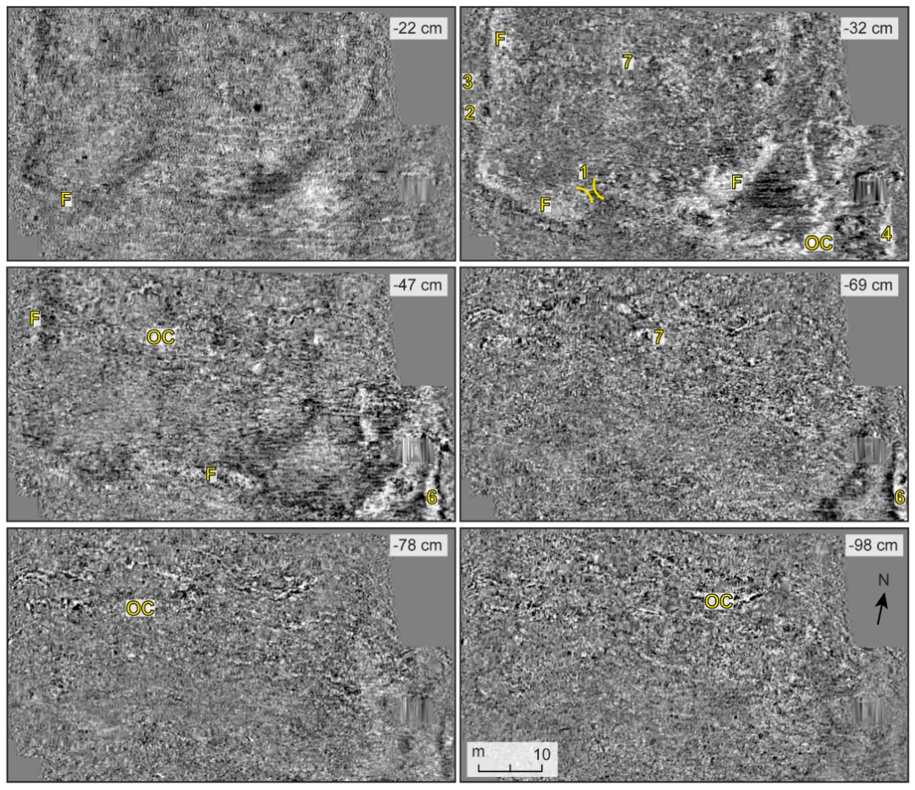
4.2. Feature 10
5. Discussion and Conclusions
Author Contributions
Funding
Informed Consent Statement
Data Availability Statement
Acknowledgments
Conflicts of Interest
References
- Kvamme, K.L. Geophysical surveys as landscape archaeology. Am. Antiq. 2003, 68, 435–457. [Google Scholar]
- Campana, S.; Piro, S. (Eds.) Seeing the Unseen—Geophysics and Landscape Archaeology; CRC Press: London, UK, 2009. [Google Scholar]
- Opitz, R.S.; Cowley, D. Interpreting Archaeological Topography: Airborne Laser Scanning, 3D Data and Ground Observation; Oxbow Books: Oxford, UK, 2013. [Google Scholar]
- Forte, M.; Campana, S. (Eds.) Digital Methods and Remote Sensing in Archaeology: Archaeology in the Age of Sensing; Springer: New York, NY, USA, 2017. [Google Scholar]
- Campana, S. Mapping the Archaeological Continuum: Filling ‘Empty’ Mediterranean Landscapes; Springer: New York, NY, USA, 2018. [Google Scholar]
- Leucci, G. Nondestructive Testing for Archaeology and Cultural Heritage: A Practical Guide and New Perspectives; Springer: Cham, Switzerland, 2019. [Google Scholar]
- Piro, S.; Goodman, D. GPR Remote Sensing in Archaeology; Springer: Berlin, Germany, 2013. [Google Scholar]
- Novo, A.; Leckebusch, J.; Goodman, D.; Morelli, G.; Piro, S.; Catanzariti, G. Advances in GPR imaging with multi-channel radar systems. J. Surv. Map. Eng. 2013, 1, 1–6. [Google Scholar]
- Trinks, I.; Hinterleitner, A.; Neubauer, W.; Nau, E.; Löcker, K.; Wallner, M.; Gabler, M.; Filzwieser, R.; Wilding, J.; Schiel, H.; et al. Large-area high-resolution ground-penetrating radar measurements for archaeological prospection. Archaeol. Prospect. 2018, 25, 171–195. [Google Scholar]
- Bernardini, F.; Vinci, G.; Horvat, J.; De Min, A.; Forte, E.; Furlani, S.; Lenaz, D.; Pipan, M.; Zhao, W.; Sgambati, A.; et al. Early Roman military fortifications and the origin of Trieste, Italy. Proc. Natl. Acad. Sci. USA 2015, 112, E1520–E1529. [Google Scholar] [PubMed]
- Curry, S.; Stine, R.; Stine, L.; Nave, J.; Burt, R.; Turner, J. Terrestrial Lidar and GPR Investigations into the Third Line of Battle at Guilford Courthouse National Military Park, Guilford County, North Carolina. In Digital Methods and Remote Sensing in Archaeology: Archaeology in the Age of Sensing; Forte, M., Campana, S., Eds.; Springer: New York, NY, USA, 2017; pp. 53–70. [Google Scholar]
- Gaffney, V.L.; Baldwin, E.; Bates, M.; Bates, C.R.; Gaffney, C.F.; Hamilton, D.; Kinnaird, T.; Neubauer, W.; Yorston, R.; Allaby, R.; et al. A massive, Late Neolithic pit structure associated with Durrington Walls Henge. Internet Archaeol. 2020, 55. [Google Scholar] [CrossRef] [Scilit]
- Trinks, I.; Hinterleitner, A. Beyond Amplitudes: Multi-Trace Coherence Analysis for Ground-Penetrating Radar Data Imaging. Remote Sens. 2020, 12, 1583. [Google Scholar] [CrossRef] [Scilit]
- Štular, B.; Lozić, E.; Eichert, S. Airborne LiDAR-Derived Digital Elevation Model for Archaeology. Remote Sens. 2021, 13, 1855. [Google Scholar] [CrossRef] [Scilit]
- Cowley, D.C. Remote sensing for archaeological heritage management—Site discovery, interpretation and registration. In Proceedings of the 11th EAC Heritage Management Symposium, Reykjavik, Iceland, 25–27 March 2010; EAC Occasional Paper No. 5. Cowley, D.C., Ed.; Europae Archaeologiae Consilium: Brussels, Belgium, 2011; p. 312. [Google Scholar]
- Cowley, D.; Banaszek, Ł.; Geddes, G.; Gannon, A.; Middleton, M.; Millican, K. Making LiGHT Work of Large Area Survey? Developing Approaches to Rapid Archaeological Mapping and the Creation of Systematic National-scaled Heritage Data. J. Comput. App. Archaeol. 2020, 3, 109–121. [Google Scholar] [CrossRef] [Scilit]
- Bunting, C.; Branch, N.; Robinson, S.; Johnes, P. Ground penetrating radar as a tool to improve heritage management of wetlands. In Proceedings of the 15th International Conference on Ground Penetrating Radar 2014, Brussels, Belgium, 30 June–4 July 2014; pp. 54–59. [Google Scholar] [CrossRef] [Scilit]
- Boschi, F. (Ed.) Looking to the Future, Caring for the Past. Preventive Archaeology in Theory and Practice; Bononia University Press: Bologna, Italy, 2016. [Google Scholar]
- Neubauer, W. Die Entdeckung des Forums der Zivilstadt. In Carnuntum. Wiedergeborene Stadt der Kaiser; Humer, F., Ed.; Von Zabern: Darmstadt, Germany, 2014; pp. 88–89. [Google Scholar]
- Filzwieser, R.; Ivanišević, V.; Verhoeven, G.J.; Gugl, C.; Löcker, K.; Bugarski, I.; Schiel, H.; Wallner, M.; Trinks, I.; Trausmuth, T.; et al. Integrating Geophysical and Photographic Data to Visualize the Quarried Structures of the Roman Town of Bassianae. Remote Sens. 2021, 13, 2384. [Google Scholar] [CrossRef] [Scilit]
- Puente, I.; Solla, M.; Lagüela, S.; Sanjurjo-Pinto, J. Reconstructing the Roman Site “Aquis Querquennis” (Bande, Spain) from GPR, T-LiDAR and IRT Data Fusion. Remote Sens. 2018, 10, 379. [Google Scholar] [CrossRef] [Scilit]
- Verdonck, L.; Launaro, A.; Vermeulen, F.; Millett, M. Ground-penetrating radar survey at Falerii Novi: A new approach to the study of Roman cities. Antiquity 2020, 94, 705–723. [Google Scholar] [CrossRef] [Scilit]
- Bernardini, F.; Vinci, G. Archaeological landscape in central northern Istria (Croatia) revealed by airborne LiDAR: From prehistoric sites to Roman centuriation. Archaeol. Anthropol. Sci. 2020, 12, 133. [Google Scholar] [CrossRef] [Scilit]
- Felja, I.; Fontana, A.; Furlani, S.; Bajraktarević, Z.; Paradžik, A.; Topalović, E.; Rossato, S.; Ćosović, V.; Juračić, M. Environmental changes in the lower Mirna River valley (Istria, Croatia) during Upper Holocene. Geol. Croat. 2015, 68, 209–224. [Google Scholar] [CrossRef] [Scilit]
- D’Incà, C. Il Porto Quieto e il fiume: Un mutare di funzioni e di paesaggi tra l’Istria costiera e l’interno. In Terre di Mare. L’archeologia dei Paesaggi Costieri e le Variazioni Climatiche; Snjezana, K., Auriemma, R., Eds.; Università degli Studi di Trieste-Pomorski Muzej: Trieste, Italy, 2008; pp. 155–161. [Google Scholar]
- D’Ambrosi, C. Note illustrative alla Carta geologica delle Tre Venezie—Foglio “Pisino”; Società Cooperativa Tipografica: Padova, Italy, 1931. [Google Scholar]
- Osović, V.; Moro, A. Geologia dell’Istria—Un’introduzione. In Giornate di Paleontologia 2006: Escursione nel Carso Triestino, in Slovenia e Croazia; EUT: Trieste, Italy, 2016; pp. 46–50. [Google Scholar]
- Komšo, D. Pecina Laganiši, Mjestoživota i Smrt. Izložba–Exhibition; Arheološki muzej Istre: Pula, Croatia, 2008. [Google Scholar]
- Mihovilić, K. Castellieri-Gradine of the Northern Adriatic. In The Oxford Handbook of the European Bronze Age; Harding, A., Fokkens, H., Eds.; Oxford University Press: Oxford, UK, 2013; pp. 864–876. [Google Scholar]
- Buršić-Matijašić, K. Gradine Istre. Povijest prije Povijesti; ŽakanJuri: Pula, Croatia, 2007. [Google Scholar]
- Grasmueck, M.; Weger, R.; Horstmeyer, H. Full-resolution 3D GPR imaging. Geophysics 2005, 70, K12–K19. [Google Scholar] [CrossRef] [Scilit]
- Böniger, U.; Tronicke, J. Integrated data analysis at an archaeological site: A case study using 3D GPR, magnetic, and high-resolution topographic data. Geophysics 2010, 75, B169–B176. [Google Scholar] [CrossRef] [Scilit]
- Böniger, U.; Tronicke, J. Improving the interpretability of 3D GPR data using target—Specific attributes: Application to tomb detection. J. Archaeol. Sci. 2010, 37, 360–367. [Google Scholar] [CrossRef] [Scilit]
- Novo, A.; Grasmueck, M.; Viggiano, D.A.; Lorenzo, H. 3D GPR in Archaeology: What can be gained from dense Data Acquisition and Processing? In Proceedings of the 12th International Conference on Ground Penetrating Radar, Birmingham, UK, 16–19 June 2008. [Google Scholar]
- Stolt, R.H. Migration by Fourier Transforrm. Geophysics 1978, 43, 23–48. [Google Scholar] [CrossRef] [Scilit]
- Borgna, E.; Càssola Guida, P.; Mihovilić, K.; Tasca, G.; Teržan, B. Bronzo Antico-Bronzo Recente. In Preistoria e Protostoria del ‘Caput Adriae’; Borgna, E., Càssola Guida, P., Corazza, S., Eds.; Istituto di Preistoria e Protostoria: Firenze, Italy, 2018; pp. 75–96. [Google Scholar]
- Codacci-Terlević, G. La scoperta della sepoltura a tumulo di Barbariga (Istria, Croazia). Novità e riscontri in relazione ai tumuli dell’età del bronzo rinvenuti nella penisola istriana e nell’Italia nord-orientale. In Ancestral Landscapes: Burial Mounds in the Copper and Bronze Ages (Central and Eastern Europe–Balkans–Adriatic–Aegean, 4th-2nd Millennium B.C.), Proceedings of the International Conference, Udine, Italy, 15–18 May 2008; Borgna, E., Müller-Celka, S., Eds.; Maison de l’Orient et de la Méditerranée: Lyon, France, 2012; pp. 153–162. [Google Scholar]
- Mihovilić, K.; Hänsel, B.; Matošević, D.; Teržan, B. Burial Mounds of the Bronze Age at Mušego near Monkodonja. Results of the Excavations 2006–2007. In Ancestral Landscapes: Burial Mounds in the Copper and Bronze Ages (Central and Eastern Europe–Balkans–Adriatic–Aegean, 4th-2nd Millennium B.C.), Proceedings of the International Conference, Udine, Italy, 15–18 May 2008; Borgna, E., Müller-Celka, S., Eds.; Maison de l’Orient et de la Méditerranée: Lyon, France, 2012; pp. 367–373. [Google Scholar]
- Hänsel, B.; Mihovilić, K.; Teržan, B. Monkodonja. Istraživanja Protourbanog na-selja Brončanog doba Istre. Knjiga 1. Iskopavanje i Nalazi Građevina/Monkodonja. Forschungen zu einer Protourbanen Siedlung der Bronzezeit Istriens. Teil 1. Die Grabung und der Baubefund; Monografije i katalozi/Monographien und Kataloge 25; Arheološki muzej Istre/Archäologisches Museum Istriens: Pula, Croatia, 2015. [Google Scholar]
- Hänsel, B.; Mihovilić, K.; Teržan, B. Fortification Concepts of the Bronze Age Hillforts in Istria. In Bronze Age fortresses in Europe, Proceedings of the Second International LOEWE Conference, Alba Julia, Romania, 9–13 October 2017; Hanse, S., Rüdiger, K., Eds.; Verlag Dr. Rudolf Habelt GmbH: Bonn, Germany, 2019; pp. 99–115. [Google Scholar]
- Cupitò, M.; Tasca, G.; Pulcini, M.L.; Carrara, N.; Lotto, D.; Gozzi, E.; Scaggio, C.; Canci, A.; Valzolgher, E. Il “sepolcreto gentilizio” del castelliere di Monte Orcino/Vrčin—Scavi Battaglia-Tamaro 1925–1928. Rilettura del contesto archeologico e risultati del riesame bioarcheologico dei resti umani. In Preistoria e Protostoria del ‘Caput Adriae’; Borgna, E., Càssola Guida, P., Corazza, S., Eds.; Istituto di Preistoria e Protostoria: Firenze, Italy, 2018; pp. 509–526. [Google Scholar]
- Vitasović, A. Gradina. Histria Archaeol. 2002, 31, 5–60. [Google Scholar]
- Vitasović, A. La cultura dei castellieri sulle isole Brioni. In Carlo Marchesetti e i Castellieri, 1903–2003; Bandelli, G., Montagnari Kokelj, E., Eds.; Editreg: Trieste, Italy, 2005; pp. 301–324. [Google Scholar]
- Recchia, G.; Cazzella, A. Coppa Nevigata in the wider context of Bronze Age fortified settlements of south-eastern Italy and the Adriatic area. In Bronze Age Fortresses in Europe, Proceedings of the Second International LOEWE Conference, Alba Julia, Romania, 9–13 October 2017; Hanse, S., Rüdiger, K., Eds.; Verlag Dr. Rudolf Habelt GmbH: Bonn, Germany, 2019; pp. 81–97. [Google Scholar]
- Brown, K.A. A Passion for Excavation. Labour Requirements and Possible for the Ditches of the “Villaggi trincerati” of the Tavoliere, Apulia. Accord. Res. Pap. 1991, 2, 7–30. [Google Scholar]




| Total m3 | m3 Coefficient | Work-Day | People Involved | Days |
|---|---|---|---|---|
| 56 | 1 | 56 | 4 | 14 |
| 56 | 1 | 56 | 8 | 7 |
| 56 | 1 | 56 | 16 | 3.5 |
| 56 | 1 | 56 | 32 | 1.75 |
| 56 | 1.25 | 44.8 | 4 | 11.2 |
| 56 | 1.25 | 44.8 | 8 | 5.6 |
| 56 | 1.25 | 44.8 | 16 | 2.8 |
| 56 | 1.25 | 44.8 | 32 | 1.4 |
Publisher’s Note: MDPI stays neutral with regard to jurisdictional claims in published maps and institutional affiliations. |
© 2021 by the authors. Licensee MDPI, Basel, Switzerland. This article is an open access article distributed under the terms and conditions of the Creative Commons Attribution (CC BY) license (https://creativecommons.org/licenses/by/4.0/).
Share and Cite
Bernardini, F.; Vinci, G.; Forte, E.; Mocnik, A.; Višnjić, J.; Pipan, M. Integrating Airborne Laser Scanning and 3D Ground-Penetrating Radar for the Investigation of Protohistoric Structures in Croatian Istria. Appl. Sci. 2021, 11, 8166. https://doi.org/10.3390/app11178166
Bernardini F, Vinci G, Forte E, Mocnik A, Višnjić J, Pipan M. Integrating Airborne Laser Scanning and 3D Ground-Penetrating Radar for the Investigation of Protohistoric Structures in Croatian Istria. Applied Sciences. 2021; 11(17):8166. https://doi.org/10.3390/app11178166
Chicago/Turabian StyleBernardini, Federico, Giacomo Vinci, Emanuele Forte, Arianna Mocnik, Josip Višnjić, and Michele Pipan. 2021. "Integrating Airborne Laser Scanning and 3D Ground-Penetrating Radar for the Investigation of Protohistoric Structures in Croatian Istria" Applied Sciences 11, no. 17: 8166. https://doi.org/10.3390/app11178166
APA StyleBernardini, F., Vinci, G., Forte, E., Mocnik, A., Višnjić, J., & Pipan, M. (2021). Integrating Airborne Laser Scanning and 3D Ground-Penetrating Radar for the Investigation of Protohistoric Structures in Croatian Istria. Applied Sciences, 11(17), 8166. https://doi.org/10.3390/app11178166