
Optimal Tilt and Orientation Angles in Fixed Flat Surfaces to Maximize the Capture of Solar Insolation: A Case Study in Ecuador

 ,
,  and
and 
Abstract
1. Introduction
- Five irradiance transposition models are used to calculate the capture of solar insolation
- Various cities in Ecuador are studied to assess the impact of the location in the capture of solar insolation
- The performance of each model is evaluated in the selected cities
2. Materials and Methods
- Solar insolation: The amount of solar radiation received from the Sun and expressed in Wh/m2.
- Solar irradiance: The instantaneous power per unit area received from the Sun on the Earth’s surface and expressed in W/m2. The irradiance is measured in the wavelength range of the measuring instrument.
- Ground reflectance (albedo): The portion of solar insolation incident on the ground that is reflected.
- Sky clarity index: The ratio of measured insolation relative to insolation outside the atmosphere calculated in the given location.
2.1. Isotropic Diffuse Model
2.2. Liu and Jordan Model
2.3. Temps and Coulson Model
2.4. Klucher Model
2.5. Pérez Model
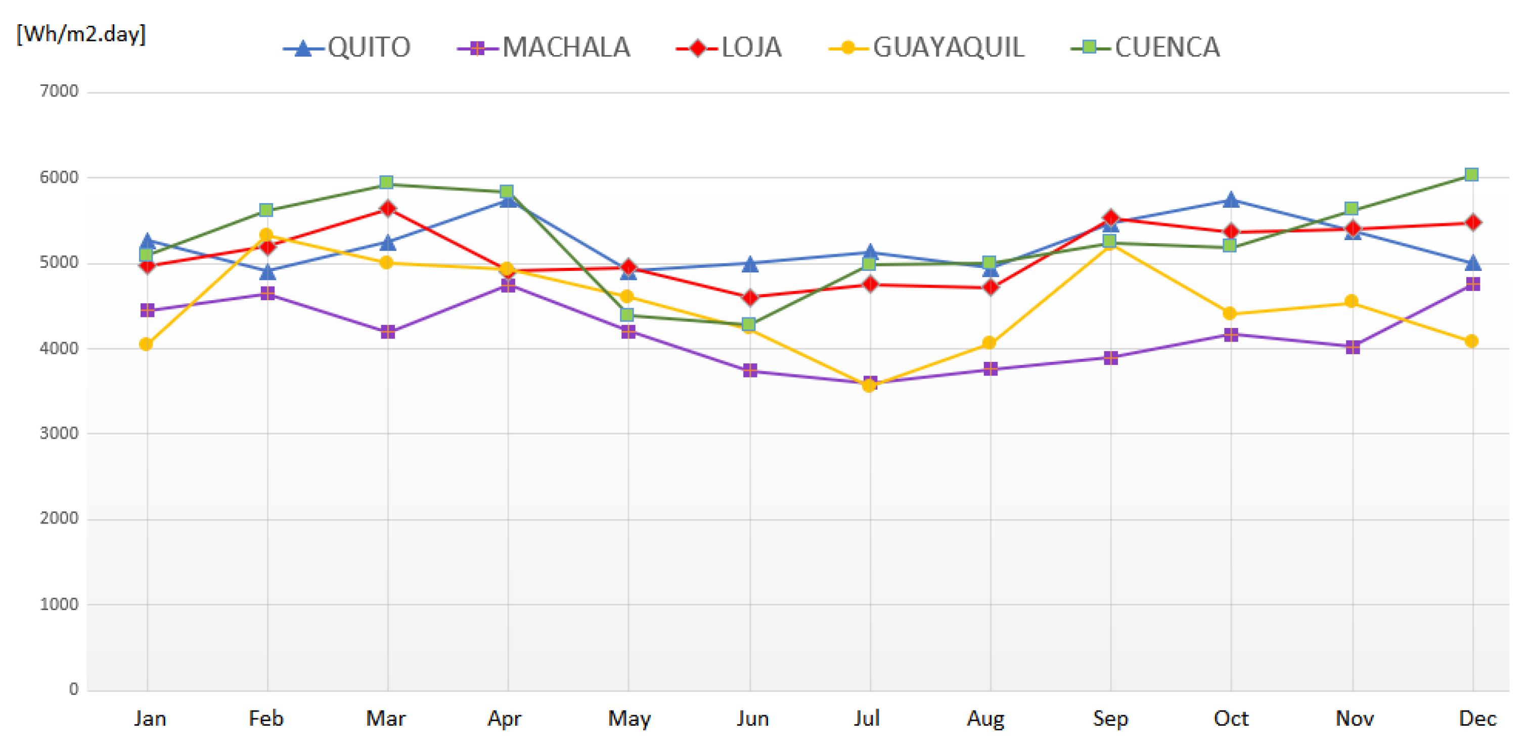
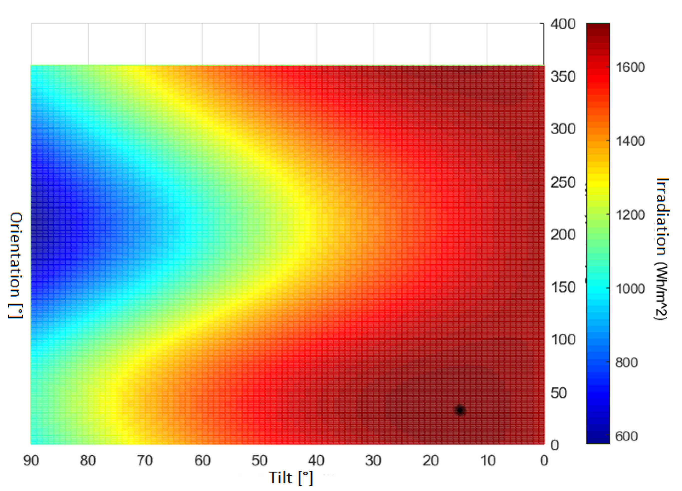
3. Results and Discussion
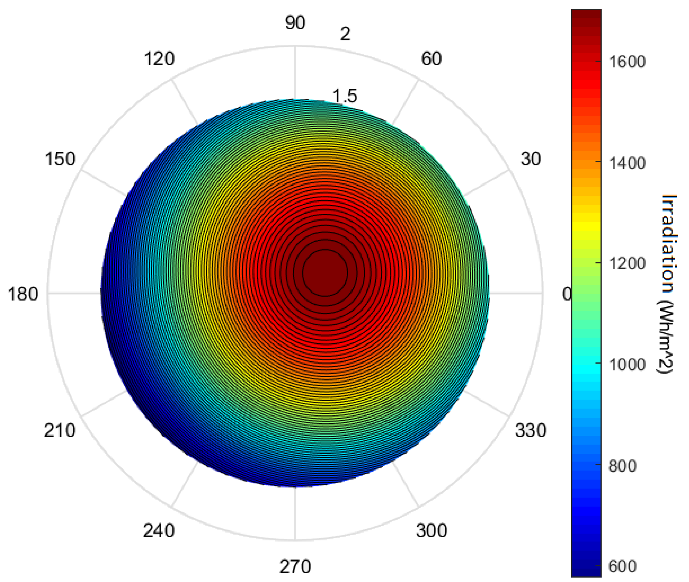
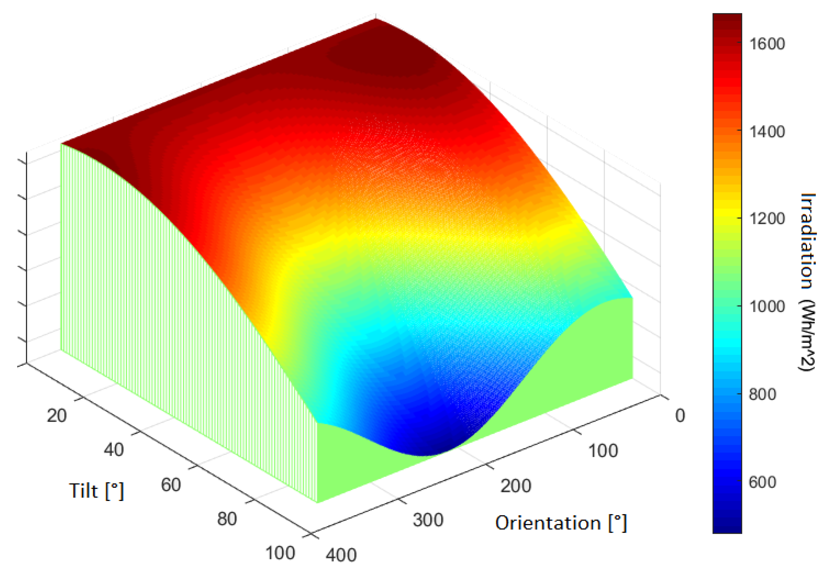
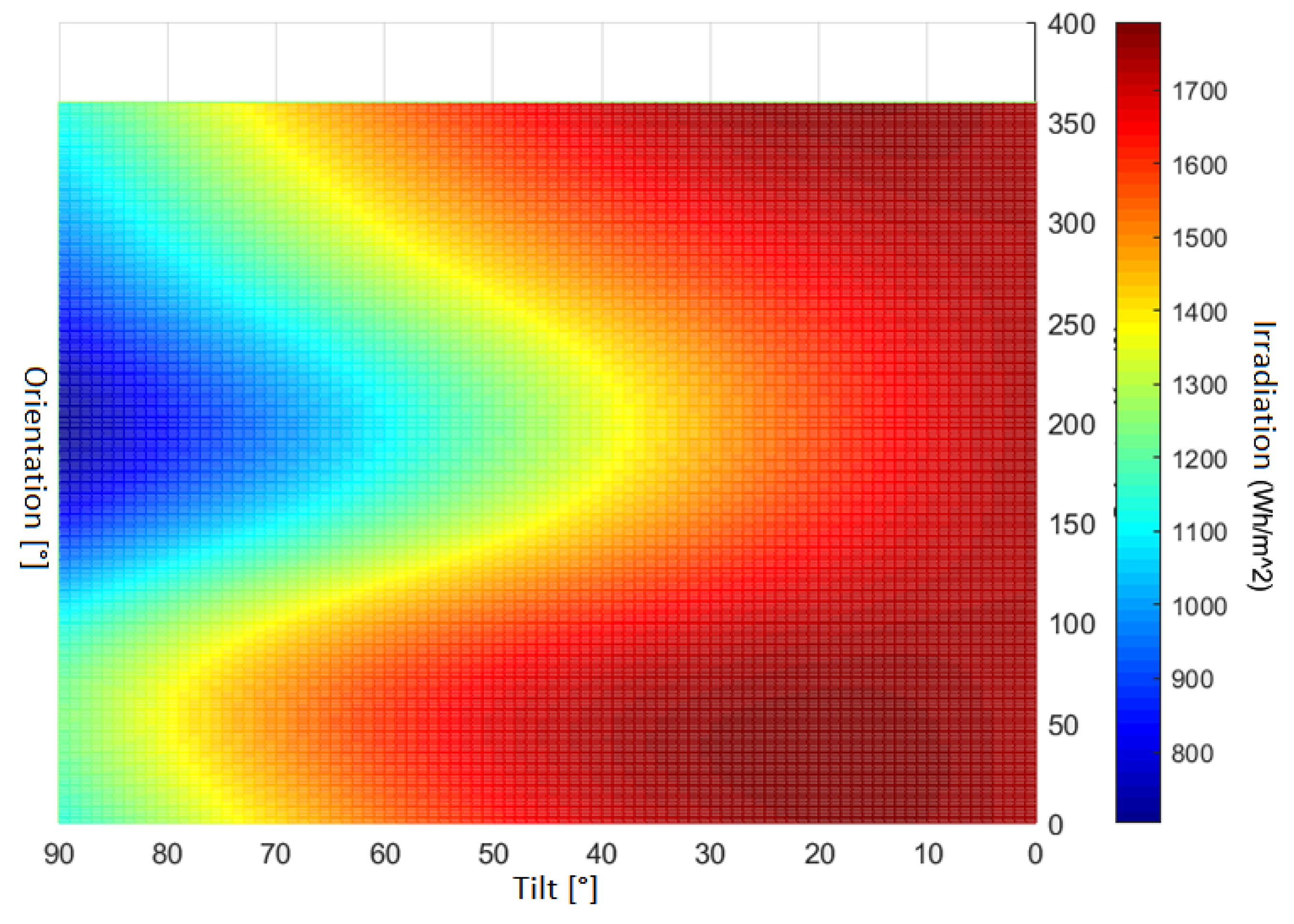
3.1. Optimal Tilt and Orientation Angles
3.2. Assessment of the Selected Models
3.3. Recommendations for the Optimal Orientation in Ecuador
3.4. Discussion
4. Conclusions
Author Contributions
Funding
Institutional Review Board Statement
Informed Consent Statement
Data Availability Statement
Conflicts of Interest
Abbreviations
| TMY | Typical Meteorological Years |
| PV | Photovoltaic |
| RE | Renewable Energy |
References
- Izquierdo-Torres, I.F.; Pacheco-Portilla, M.G.; Gonzalez-Morales, L.G.; Zalamea-Leon, E.F. Simulacion fotovoltaica considerando parametros de integracion en edificaciones. Ingenius. Revista de Ciencia y Tecnología 2019, 21, 21–31. [Google Scholar] [CrossRef]
- Clairand, J.M.; Álvarez-Bel, C.; Rodríguez-García, J.; Escrivá-Escrivá, G. Impact of Electric Vehicle Charging Strategy on the Long-Term Planning of an Isolated Microgrid. Energies 2020, 13, 3455. [Google Scholar] [CrossRef]
- Travaillé, P.; Benamar, A.; Clairand, J.M.; Escrivá-Escrivá, G. Operation of DC Microgrids Considering Different Strategies of Electric Vehicle Charging. In Proceedings of the 2020 IEEE ANDESCON, Quito, Ecuador, 13–16 October 2020; pp. 1–5. [Google Scholar] [CrossRef]
- Spencer, J.W. Fourier series reprensentation of the position of the sun. Search 1971, 2, 172. [Google Scholar]
- Erbs, D.G.; Klein, S.A.; Duffie, J.A. Estimation of the diffuse radiation fraction for hourly, daily and monthly-average global radiation. Sol. Energy 1982, 28, 293–302. [Google Scholar] [CrossRef]
- Reindl, D.T.; Beckman, W.A.; Duffie, J.A. Diffuse fraction correlations. Sol. Energy 1990, 45, 1–7. [Google Scholar] [CrossRef]
- Liu, B.; Jordan, R. Daily insolation on surfaces tilted towards equator. ASHRAE J. 1961, 10. [Google Scholar]
- Hay, J.E. Calculation of monthly mean solar radiation for horizontal and inclined surfaces. Sol. Energy 1979, 23, 301–307. [Google Scholar] [CrossRef]
- Gueymard, C. An anisotropic solar irradiance model for tilted surfaces and its comparison with selected engineering algorithms. Sol. Energy 1987, 38, 367–386. [Google Scholar] [CrossRef]
- Kambezidis, H.D.; Psiloglou, B.E.; Gueymard, C. Measurements and models for total solar irradiance on inclined surface in Athens, Greece. Sol. Energy 1994, 53, 177–185. [Google Scholar] [CrossRef]
- Housmans, C.; Ipe, A.; Bertrand, C. Tilt to horizontal global solar irradiance conversion: An evaluation at high tilt angles and different orientations. Renew. Energy 2017, 113, 1529–1538. [Google Scholar] [CrossRef]
- Khan, R.A.; Mahmood, M.R.; Haque, A. Enhanced energy extraction in an open loop single-axis solar tracking PV system with optimized tracker rotation about tilted axis. J. Renew. Sustain. Energy 2018, 10. [Google Scholar] [CrossRef]
- Halilovic, S.; Bright, J.M.; Herzberg, W.; Killinger, S. An analytical approach for estimating the global horizontal from the global tilted irradiance. Sol. Energy 2019, 188, 1042–1053. [Google Scholar] [CrossRef]
- Campana, P.E.; Landelius, T.; Andersson, S.; Lundström, L.; Nordlander, E.; He, T.; Zhang, J.; Stridh, B.; Yan, J. A gridded optimization model for photovoltaic applications. Sol. Energy 2020, 202, 465–484. [Google Scholar] [CrossRef]
- Gómez-Uceda, F.J.; Moreno-Garcia, I.M.; Jiménez-Martínez, J.M.; López-Luque, R.; Fernández-Ahumada, L.M. Analysis of the influence of terrain orientation on the design of pv facilities with single-axis trackers. Appl. Sci. 2020, 10, 8531. [Google Scholar] [CrossRef]
- Wattan, R.; Janjai, S. An investigation of the performance of 14 models for estimating hourly diffuse irradiation on inclined surfaces at tropical sites. Renew. Energy 2016, 93, 667–674. [Google Scholar] [CrossRef]
- Ihaddadene, N.; Ihaddadene, R.; Charik, A. Best Tilt Angle of Fixed Solar Conversion Systems at M’Sila Region (Algeria). Energy Procedia 2017, 118, 63–71. [Google Scholar] [CrossRef]
- Koussa, M.; Saheb-Koussa, D.; Hadji, S. Experimental investigation of simple solar radiation spectral model performances under a Mediterranean Algerian’s climate. Energy 2017, 120, 751–773. [Google Scholar] [CrossRef]
- Raptis, P.I.; Kazadzis, S.; Psiloglou, B.; Kouremeti, N.; Kosmopoulos, P.; Kazantzidis, A. Measurements and model simulations of solar radiation at tilted planes, towards the maximization of energy capture. Energy 2017, 130, 570–580. [Google Scholar] [CrossRef]
- Seme, S.; Sredenšek, K.; Štumberger, B.; Hadžiselimović, M. Analysis of the performance of photovoltaic systems in Slovenia. Sol. Energy 2019, 180, 550–558. [Google Scholar] [CrossRef]
- Mubarak, R.; Hofmann, M.; Riechelmann, S.; Seckmeyer, G. Comparison of modelled and measured tilted solar irradiance for photovoltaic applications. Energies 2017, 10, 1688. [Google Scholar] [CrossRef]
- Nassar, Y.F.; Hafez, A.A.; Alsadi, S.Y. Multi-Factorial Comparison for 24 Distinct Transposition Models for Inclined Surface Solar Irradiance Computation in the State of Palestine: A Case Study. Front. Energy Res. 2020, 7, 1–19. [Google Scholar] [CrossRef]
- Toledo, C.; Amillo, A.M.G.; Bardizza, G.; Abad, J.; Urbina, A. Evaluation of solar radiation transposition models for passive energy management and building integrated photovoltaics. Energies 2020, 13, 702. [Google Scholar] [CrossRef]
- Costa, S.C.; Kazmerski, L.L.; Diniz, A.S.A. Estimate of Soiling Rates Based on Soiling Monitoring Station and PV System Data: Case Study for Equatorial-Climate Brazil. IEEE J. Photovoltaics 2021, 11, 461–468. [Google Scholar] [CrossRef]
- Trewin, B. The climates of the tropics and how they are changing. State Trop. 2014, 1, 39–52. [Google Scholar]
- Bykerk-Kauffman, A. Seasons and Why the Equator is Warmer Than the Poles. Pedagogy in Action the SERC Portal for Educators. Sci. Educ. Resour. Center. 2018. Available online: https//goo.gl/vsDCFB (accessed on 9 May 2021).
- Serrano-Guerrero, X.; Escrivá-Escrivá, G.; Luna-Romero, S.; Clairand, J.M. A Time-Series Treatment Method to Obtain Electrical Consumption Patterns for Anomalies Detection. Energies 2020, 13, 1046. [Google Scholar] [CrossRef]
- IRENA. A World of Renewables. Int. Renew. Energy Agency 2006, 1–68. Available online: https://www.irena.org/-/media/Files/IRENA/Agency/Publication/2015/IRENA_GlobalAtlas_World_of_Renewables_2015.pdf (accessed on 9 May 2021).
- Serrano, X.; Narváez, M.; Urigüen, C.; Escrivá-Escrivá, G. Quantitative assessment of hybrid systems of heating domestic water based on solar energy in andean zones of Ecuador. In Proceedings of the 2016 51st International Universities Power Engineering Conference (UPEC), Coimbra, Portugal, 6–9 September 2016; pp. 1–6. [Google Scholar]
- Serrano-Guerrero, X.; Alvarez-Lozano, D.; Romero, S.F.L. Influence of local climate on the tilt and orientation angles in fixed flat surfaces to maximize the capture of solar irradiation: A case study in Cuenca-Ecuador. In Proceedings of the 2019 IEEE International Autumn Meeting on Power, Electronics and Computing (ROPEC), Guerrero, Mexico, 13–15 November 2019; pp. 1–6. [Google Scholar]
- Instituto de Investigación Geológico y Energético—Ecuador. Available online: https://www.geoenergia.gob.ec/ (accessed on 9 May 2021).
- Temps, R.C.; Coulson, K.L. Solar radiation incident upon slopes of different orientations. Sol. Energy 1977, 19, 179–184. [Google Scholar] [CrossRef]
- Klucher, T.M. Evaluation of models to predict insolation on tilted surfaces. Sol. Energy 1979, 23, 111–114. [Google Scholar] [CrossRef]
- Perez, R.; Ineichen, P.; Seals, R.; Michalsky, J.; Stewart, R. Modeling daylight availability and irradiance components from direct and global irradiance. Sol. Energy 1990, 44, 271–289. [Google Scholar] [CrossRef]
- Rudniak, J. Comparison of local solar radiation parameters with data from a typical meteorological year. Therm. Sci. Eng. Prog. 2020, 16, 100465. [Google Scholar] [CrossRef]
- Li, D.H.W.; Lam, T.N.T. Determining the optimum tilt angle and orientation for solar energy collection based on measured solar radiance data. Int. J. Photoenergy 2007, 2007, 1–9. [Google Scholar] [CrossRef]
- Peña Ortiz, P.A.; Pinos Vergara, F.S. Parametrización de los sistemas eléctricos fotovoltaicos basados en las condiciones climáticas de la ciudad de Cuenca, aplicados en la Universidad Politécnica Salesiana. 2014. Available online: https://dspace.ups.edu.ec/handle/123456789/7123 (accessed on 9 May 2021).
- Pabón, L.; Tonato, D. Diseño e Implementación de un Sistema Eléctronico para Trazar el Perfil de Radiación Solar en la Terraza del Edificio C de la ESPE Latacunga Mediante Paneles Solares Fijo y Movil. Esc. Politécnica del Ejército extensión Latacunga 2012, 1–200. [Google Scholar]
- Barragán-Escandón, E.A.; Zalamea-León, E.F.; Terrados-Cepeda, J.; Vanegas-Peralta, P.F. Energy self-supply estimation in intermediate cities. Renew. Sustain. Energy Rev. 2020, 129, 109913. [Google Scholar] [CrossRef]
- Torres, I.F.I.; Portilla, M.G.P. Evaluación de la Eficiencia de Paneles Solares como Sistema de Captación de Energía Para Edificaciones del área Urbana de Cuenca. 2017. Available online: https://dspace.ucuenca.edu.ec/handle/123456789/27386 (accessed on 9 May 2021).
- Kocifaj, M.; Fecko, S. UniSky Simulator. 2014. Available online: http://www.unisky.sav.sk/?lang=en&page=aplikacia (accessed on 9 May 2021).
- Kocifaj, M. Unified model of radiance patterns under arbitrary sky conditions. Sol. Energy 2015, 115, 40–51. [Google Scholar] [CrossRef]


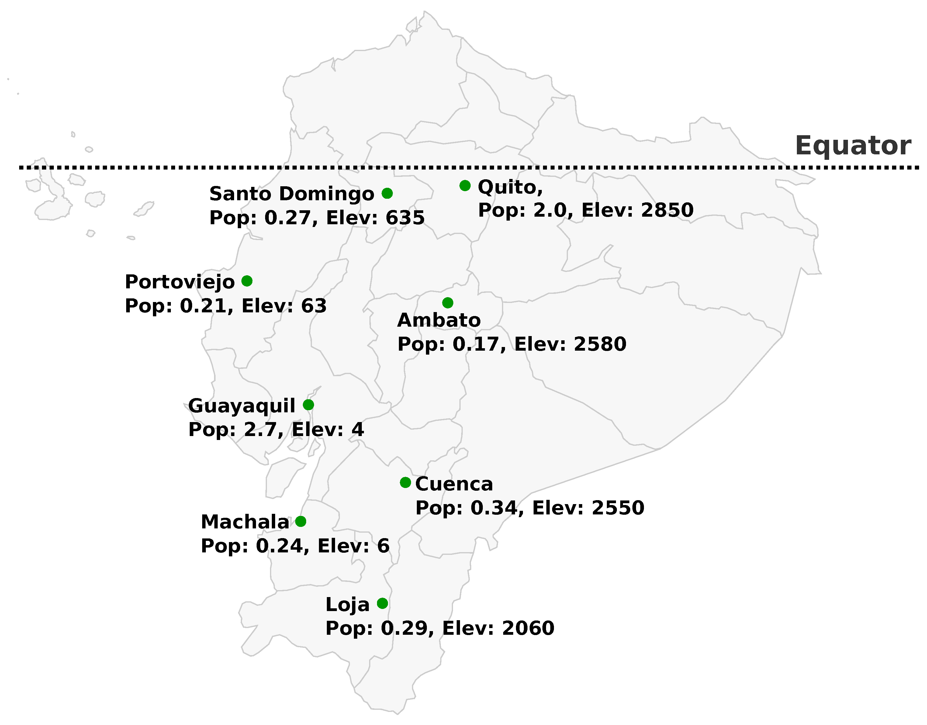
| City | Population [millions] | Latitude [°] | Longitude [°] | Elevation [m] | Data Source |
|---|---|---|---|---|---|
| Quito | 2 | −0.22 | −78.51 | 2850 | TMY file |
| Guayaquil | 2.7 | −2.2 | −79.9 | 4 | TMY file |
| Cuenca | 0.34 | −2.88 | −79.02 | 2550 | Vaisala Weather Station |
| Machala | 0.24 | −3.26 | −79.96 | 6 | TMY file |
| Loja | 0.29 | −4 | −79.2 | 2060 | TMY file |
| Santo Domingo | 0.27 | −0.25 | −79.17 | 635 | TMY file |
| Portoviejo | 0.21 | −1.06 | −80.47 | 53 | TMY file |
| Ambato | 0.17 | −1.24 | −78.63 | 2580 | TMY file |
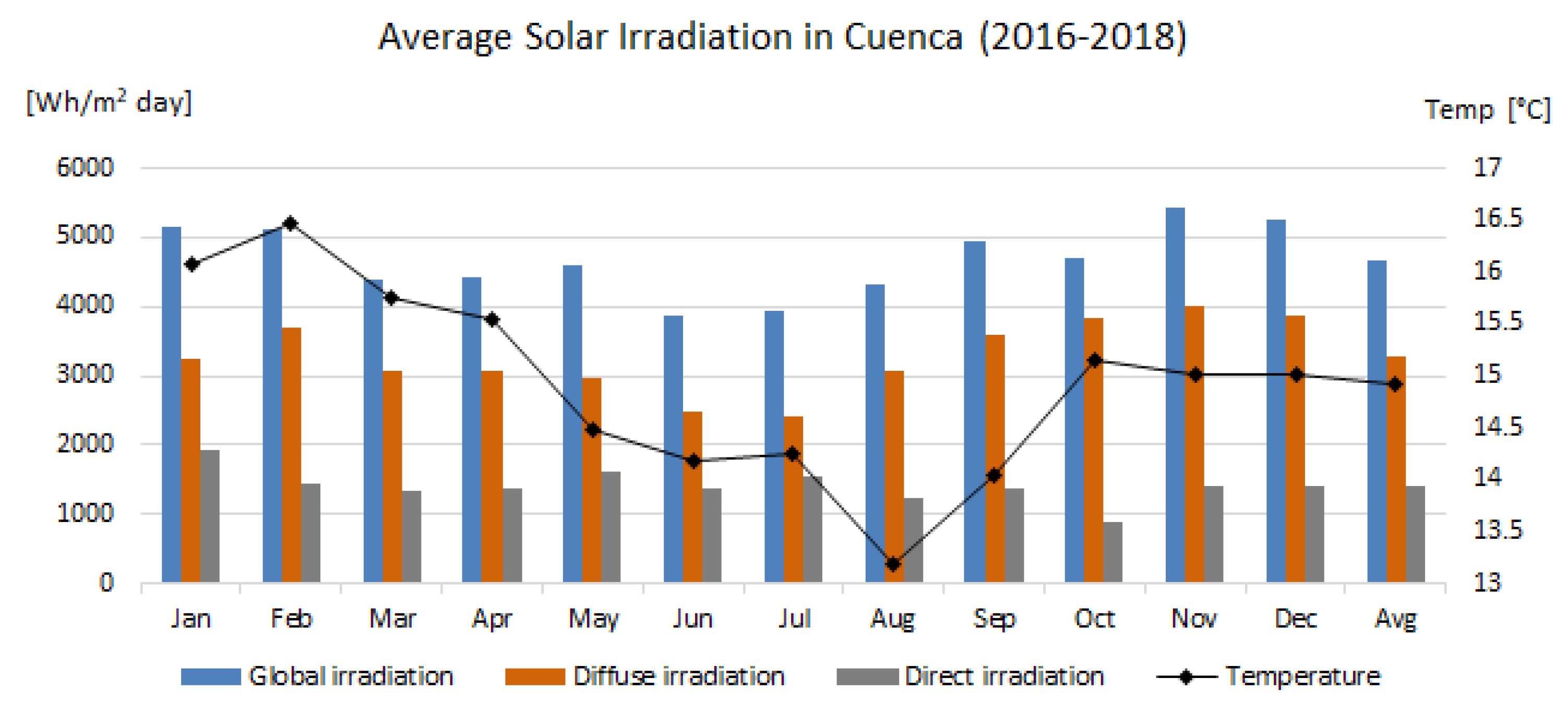
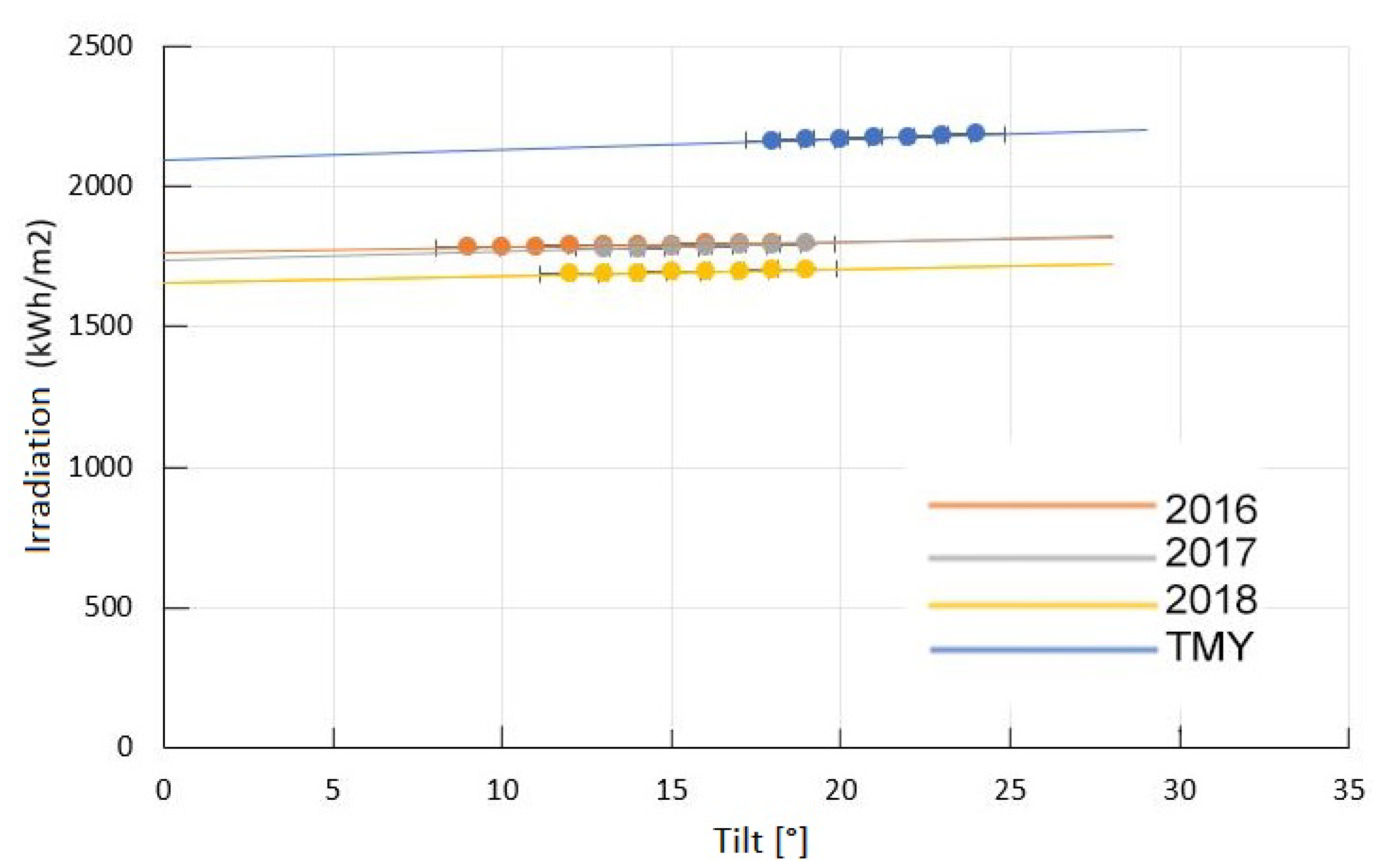
| Year | Global Insolation (Wh/m2) | Diffuse Insolation (Wh/m2) | Direct Insolation (Wh/m2) | Mean Temperature (°C) |
|---|---|---|---|---|
| 2016 | 4464.62 | 2851.53 | 1613.09 | 14.68 |
| 2017 | 4445.60 | 3275.88 | 1169.72 | 14.11 |
| 2018 | 4643.90 | 3712.2 | 931.7 | 15.28 |
| Coefficients f | ||||||
|---|---|---|---|---|---|---|
| f 11 | f 12 | f 13 | f 21 | f 22 | f 23 | |
| 0–1.065 | −0.008 | 0.58 | −0.062 | −0.06 | 0.072 | −0.022 |
| 1.065–1.23 | 0.13 | 0.683 | −0.151 | −0.019 | 0.06 | −0.029 |
| 1.23–1.5 | 0.33 | 0.487 | −0.221 | 0.055 | −0.015 | −0.026 |
| 1.5–1.95 | 0.568 | 0.188 | −0.295 | 0.109 | −0.152 | −0.014 |
| 1.95–2.8 | 0.873 | −0.392 | −0.362 | 0.226 | −0.462 | 0.001 |
| 2.8–4.5 | 1.13 | −1.237 | −0.412 | 0.288 | −0.823 | 0.056 |
| 4.5–6.2 | 1.06 | −1.6 | −0.359 | 0.264 | −1.127 | 0.131 |
| >6.2 | 0.678 | −0.327 | −0.25 | 0.156 | −1.377 | 0.251 |
| Irradiance, Inclination, and Orientation Values | |||||||||
|---|---|---|---|---|---|---|---|---|---|
| Models | Diffuse Isotropic | Liu and Jordan | Temps and Coulson | ||||||
| Cities | (Wh/m2) | I (°) | O (°) | (Wh/m2) | I (°) | O (°) | (Wh/m2) | I (°) | O (°) |
| Guayaquil | 1823.064 | 18 | 50 | 1823.064 | 18 | 50 | 1935.033 | 21 | 51 |
| Quito | 2089.807 | 17 | 35 | 2089.837 | 18 | 35 | 2187.17 | 19 | 35 |
| Cuenca | 2184.402 | 18 | 34 | 2184.402 | 18 | 36 | 2282.8 | 20 | 36 |
| Santo Domingo | 1628.135 | 17 | 46 | 1367.136 | 17 | 46 | 1729.643 | 19 | 47 |
| Machala | 1732.026 | 19 | 51 | 1732.026 | 19 | 51 | 1843.007 | 22 | 52 |
| Portoviejo | 1894.892 | 20 | 53 | 1895.89 | 20 | 53 | 2008.308 | 23 | 53 |
| Loja | 2159.481 | 19 | 40 | 2159.481 | 20 | 40 | 2259.794 | 21 | 40 |
| Ambato | 2120.749 | 19 | 38 | 2120.749 | 19 | 38 | 2218.019 | 20 | 38 |
| Irradiance, Inclination, and Orientation Values | ||||||
|---|---|---|---|---|---|---|
| Models | Klucher | Pérez | ||||
| Cities | (Wh/m2) | I (°) | O (°) | (Wh/m2) | I (°) | O (°) |
| Guayaquil | 1878.34 | 20 | 51 | 1777.555 | 23 | 52 |
| Quito | 2142.09 | 18 | 35 | 2456.078 | 17 | 38 |
| Cuenca | 2240.651 | 19 | 36 | 2627.494 | 18 | 37 |
| Santo Domingo | 1671.294 | 18 | 47 | 1551.653 | 22 | 49 |
| Machala | 1783.287 | 20 | 52 | 1644.508 | 25 | 53 |
| Portoviejo | 1952.73 | 21 | 53 | 1895.283 | 24 | 54 |
| Loja | 2217.426 | 21 | 40 | 2561.746 | 22 | 38 |
| Ambato | 2175.057 | 19 | 38 | 2521.848 | 18 | 39 |
Publisher’s Note: MDPI stays neutral with regard to jurisdictional claims in published maps and institutional affiliations. |
© 2021 by the authors. Licensee MDPI, Basel, Switzerland. This article is an open access article distributed under the terms and conditions of the Creative Commons Attribution (CC BY) license (https://creativecommons.org/licenses/by/4.0/).
Share and Cite
Serrano-Guerrero, X.; Cantos, E.; Feijoo, J.-J.; Barragán-Escandón, A.; Clairand, J.-M. Optimal Tilt and Orientation Angles in Fixed Flat Surfaces to Maximize the Capture of Solar Insolation: A Case Study in Ecuador. Appl. Sci. 2021, 11, 4546. https://doi.org/10.3390/app11104546
Serrano-Guerrero X, Cantos E, Feijoo J-J, Barragán-Escandón A, Clairand J-M. Optimal Tilt and Orientation Angles in Fixed Flat Surfaces to Maximize the Capture of Solar Insolation: A Case Study in Ecuador. Applied Sciences. 2021; 11(10):4546. https://doi.org/10.3390/app11104546
Chicago/Turabian StyleSerrano-Guerrero, Xavier, Eduardo Cantos, Juan-Javier Feijoo, Antonio Barragán-Escandón, and Jean-Michel Clairand. 2021. "Optimal Tilt and Orientation Angles in Fixed Flat Surfaces to Maximize the Capture of Solar Insolation: A Case Study in Ecuador" Applied Sciences 11, no. 10: 4546. https://doi.org/10.3390/app11104546
APA StyleSerrano-Guerrero, X., Cantos, E., Feijoo, J.-J., Barragán-Escandón, A., & Clairand, J.-M. (2021). Optimal Tilt and Orientation Angles in Fixed Flat Surfaces to Maximize the Capture of Solar Insolation: A Case Study in Ecuador. Applied Sciences, 11(10), 4546. https://doi.org/10.3390/app11104546