Article

An Evaluation of Vegetation Health in and around Southern African National Parks during the 21st Century (2000–2016)

1
Department of Geography, University of Tennessee, 1000 Philip Fulmer Way, Room 315, Knoxville, TN 37996-0925, USA
2
Department of Geography, University of Florida, 3141 Turlington Hall, Gainesville, FL 32611, USA
3
Department of Geography, Environment, and Spatial Sciences; Michigan State University, 673 Auditorium Rd., East Lansing, MI 48825, USA
*
Author to whom correspondence should be addressed.
Appl. Sci. 2020, 10(7), 2366; https://doi.org/10.3390/app10072366
Submission received: 28 February 2020 / Revised: 23 March 2020 / Accepted: 26 March 2020 / Published: 30 March 2020
(This article belongs to the Special Issue Dynamics of the Global Savanna and Grassland Biomes)

Abstract

:
Roughly 65% of the African continent is classified as savanna. Such regions are of critical importance given their high levels of biological productivity, role in the carbon cycle, structural differences, and support of large human populations. Across southern Africa there are 79 national parks within savanna landscapes. Understanding trends and factors of vegetation health in these parks is critical for proper management and sustainability. This research strives to understand factors and trends in vegetation health from 2000 to 2016 in and around the 79 national parks across southern Africa. A backward stepwise regression was used to understand the factors (e.g., precipitation, population density, and presence of transfrontier conservation areas) affecting the normalized difference vegetation index (NDVI) during the 21st century. There was a statistically significant positive (p < 0.05) relationship between mean annual precipitation and NDVI, and a significant negative relationship between population density and NDVI. To monitor vegetation trends in and around the parks, directional persistence, a seasonal NDVI time series-based trend analysis, was used. Directional persistence is the net accumulation of directional change in NDVI over time in a given period relative to a fixed benchmarked period. Parks and buffer zones across size classes were compared to examine differences in vegetation health. There was an overwhelmingly positive trend throughout. Additionally, national parks, overall, had higher amounts of positive persistence and lower amounts of negative persistence than the surrounding buffer zones. Having higher positive persistence inside of parks indicates that they are functioning favorably relative to the buffer zones in terms of vegetation resilience. This is an important finding for park managers and conservation overall in Southern Africa.

1. Introduction

Globally, drylands cover around 50% of the earth’s terrestrial surface [1]. Of these drylands, savannas cover extensive portions of Africa, South America, and Australia. In southern Africa, over 55% of the landscape is classified as savanna [1,2]. Savannas are a type of dryland, and therefore are water limited systems. They are traditionally defined as grasslands with scattered trees, but practically are defined as a heterogeneous landscape composed of a mix of grasses, shrubs, and trees [1,3,4]. Savannas play a key role in the global carbon cycle and global net primary production [5,6,7,8,9,10]. Due to their importance and high levels of utilization, it is critical to understand savanna landscape patterns over time for management of these systems, especially into the future under climate change. The major drivers of savanna systems are precipitation, fire, herbivory, and humans [11,12,13,14]. Parks and protected areas are used extensively across landscapes to conserve and protect the natural vegetation and wildlife populations. Countries across southern Africa employ varied management approaches within such protected areas, as regards fire, herbivory, and human usage. These management practices range from no fire management to regular prescribed burns, no animal population control to culling of herds to maintain ideal population sizes, and allowing extractive use of resources to not permitting any human use of natural resources [15]. As such, understanding the success of such different and varied protection regimes is key.
Using remote sensing to monitor vegetation in savannas, while important, is notoriously difficult, as these landscapes are transitional with variable vegetation cover. Because a savanna can be any structure of vegetation in the gradient of grassland, shrubland, or woodland, certain continuous techniques have been developed to best study these systems over time. A significant study in the literature concerning drylands has developed a novel approach, utilizing continuous time series analyses, to show change in these systems over time [16]. Time series analysis of the normalized difference vegetation index (NDVI) is often used as a proxy for vegetation health and abundance [16,17,18,19,20,21,22]. Using such time series approaches, we can draw information about vegetation properties and ecological responses to change at a regional scale [23]. One result that has been produced in the literature is that of “greening”. Using satellite remote sensing, global greening has been observed during the 21st century by the National Aeronautics and Space Administration (NASA) and the National Oceanic and Atmospheric Administration (NOAA) [24]. Several studies have concluded that CO2 fertilization is the largest contributing factor. Other factors include nitrogen levels, land use, temperature, and climate [25,26,27].
Precipitation is known as the predominant factor in shaping landscape pattern and productivity across southern Africa [9]. In areas with up to mean annual precipitation of 750 mm, grassland dominated systems are expected [28]. More mixed systems are expected for areas with precipitation between 750 and 950 mm. For areas with precipitation above 950 mm, trees become the more common vegetation type [9,14,28,29]. Further, Campo-Bescos et al. (2013) and others found that the boundary between a mixed system and tree-dominated system is influenced by temperature [28]. Specifically, temperature and resulting decreases in soil moisture can adversely impact vegetation health and productivity in savanna systems [30]. Access to deeper ground water can also play a role in a tree’s ability to exist on the landscape [31]. Population pressure and human utilization of the landscape are increasing, putting greater pressure on protected areas through land conversion (positive impact) and extractive use of resources (negative impact) [2,32,33]. Elevation may also play a role in the health of vegetation, as elevation can constrain the growth of plants due to topographic climate effects [34].
In this study, we focus on the 79 national parks in southern Africa, all of which are some variation of savannas, varying from sparse grassland to deciduous woodland cover types. These parks are of critical importance, both socioeconomically and ecologically, as they support large human populations though tourism revenue and natural resource extraction, and support high levels of biodiversity [35,36]. Parks are important conservation features on the landscape because they tend to focus on maintaining biodiversity in vegetation and wildlife while minimizing human impacts. Theories in landscape ecology suggest that larger parks tend to be more successful in achieving their conservation goals [37], but the land matrix surrounding the park is also important. A way to better understand this matrix is to develop a comparison between the park and the surrounding matrix, or buffer zone. Buffer zones are important in their role of alleviating human impact on national parks [38]. More recently, multiple country, cross-border parks have also been developed, which are known as transfrontier conservation areas. The creation of transfrontier conservation areas is based on the landscape ecology principles of connectivity—the more connected, the better for conserving biodiversity (positive impact; [39]). It is now an important conservation question as to whether such transfrontier conservation areas are actually working and, as such, to address the landscape ecology theory that the size and connectivity of a protected area impacts the overall quality [37].
Currently, conservation development via parks and protected areas is a global phenomenon. However, such landscapes have rarely been studied on a larger scale explicitly to determine the factors of vegetation greenness or park success. This research examines factors of spatial heterogeneity in NDVI, specifically addressing the role of parks versus buffer zones or the surrounding land matrix. Such potential factors of savanna vegetation within these protected areas and their surrounding buffers include precipitation, human population density, transfrontier conservation areas, elevation, park size and area, land cover, and country. The research objectives of this study are as follows: (1) to understand the factors of vegetation health in national parks and their associated buffer zones in southern Africa; and (2) to determine how savanna vegetation persistence within these national parks and buffer zones of southern Africa varied from 2000 to 2016.

2. Materials and Methods
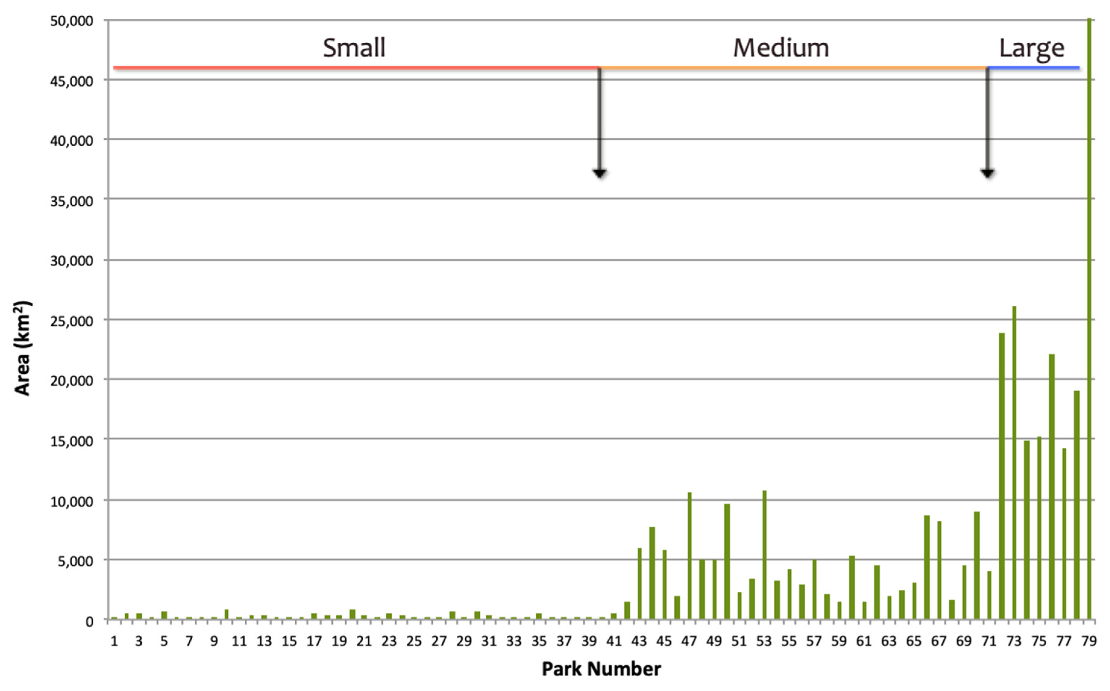
2.1. Study Area

For this study, 79 national parks across eight countries (South Africa, Zambia, Zimbabwe, Botswana, Namibia, Mozambique, Malawi, and Angola) in southern Africa were analyzed (Figure 1). Of the various protected area designations (e.g., national parks, game management areas, private game reserves), national parks were selected for their consistency in definition across countries. These parks were taken from the World Database on Protected Areas [40]. Given the spatial scale of the remote sensing techniques, only parks greater than 312,500 m2 were studied because five or more pixels at the 250 m spatial resolution were needed to be able to establish trends. For this reason, the national parks of Swaziland and Lesotho were not included in this study. Given the large variation in area across these 79 parks, using a natural breaks statistical technique, parks were broken into three main size classes: small, medium, and large (Figure 2). The small size class had a sample size of 41 and a mean area of 302 km2. The medium size class had a sample size of 30 and a mean area of 4,771 km2. The large size class had a sample size of 8 and a mean area of 23,284 km2 (Figure 2). Buffer zones with sizes of 10 km, 20 km, and 30 km were created for the small, medium, and large parks, respectively. Buffers were created to be able to compare vegetation persistence inside and outside of the park. Buffer sizes chosen for each class are based on literature suggesting that buffers be approximately three times the size of the park [38]. Across this study region, climate varies greatly and was accounted for by comparing mean annual precipitation from the Global Historical Climate Network [41]. Mean annual precipitation of parks in this study varied from 52 to 1466 mm. Land cover variations were defined as savannas with varying amounts of grass/wood biomass. These differences were taken into account by using the Global Land Project Facility data on global land cover [42] (Table A1). Of these 79 national parks, 31 are considered to be transfrontier conservation areas, which can be defined as continuous conservation areas divided by geopolitical boundaries (namely country boundaries) that are cooperating together, but may still function under different management regimes [43].

2.2. Understanding Factors of Vegetation Cover: Stepwise Backward Regression

This section addresses factors used to measure vegetation change and related factors.

2.2.1. Model Selection

A backward stepwise regression was used for this analysis because this method is capable of selecting variables with the most explanatory power from a number of input variables [44]. All assumptions of linear models were tested before employing the model: a linear relationship between dependent and independent variables, statistical independence of the errors, homoscedasticity of the errors, and confirmation that the error distribution was normal. This model has a relatively higher level of robustness for small sample sizes [44] compared to a geographically weighted regression. However, to account for the park’s spatial distribution on the landscape, we used variables that address differences across space, such as land cover, elevation, and mean annual precipitation. The model starts with all possible variables, a “full” model, and then runs several times to eliminate variables that are deemed not significant by the model. This is done by starting with all variables and then testing each variable by deleting it from the model. Variables are continuously deleted until the loss gives the least significant deterioration with the highest model fit. The final model of significant variables is referred to as a “reduced” model. The Akaike Information Criterion (AIC) is a technique that is based on in-sample fit to then estimate how well a model does at predicting future values [45]. Between models, the one with the lowest AIC is determined to be the model of best fit. Therefore, between the range of full and reduced models, the lowest AIC was used to select the best model here.

2.2.2. Model Variables

In order to understand the factors of vegetation health in and around national parks of southern Africa, the normalized difference vegetation index (NDVI) was used as a measure of vegetation health and abundance. NDVI is calculated as: N I R R N I R + R , where R is the red band and NIR is the near infrared band [46]. This index works on the principle that NIR is highly reflective in healthy vegetation and red is highly absorptive in healthy vegetation. NDVI values range from −1 and +1, with any value above 0 indicating vegetation and above 0.9 saturating out in dense healthy vegetation [46]. The NDVI product from the Moderate Resolution Imaging Spectroradiometer (MODIS) MOD13Q1.006 Terra Vegetation Index (250 m spatial resolution) was used in this research. This NDVI product was obtained from Google Earth Engine (GEE) and had been atmospherically corrected on a per-pixel basis and was also pre-masked for water, clouds, heavy aerosols, and cloud shadows. The data has also been through the quality assessment check with the provided pixel reliability band. These products are 16 day MODIS observation composites where the pixel value is equal to the NDVI value of the observation closest to nadir view. This is determined between the top two NDVI observations during a 16 day period. The monthly product used spanned from March 2000-November 2016. This data was aggregated into seasons: December, January, February (DJF)—boreal winter/southern Africa wet season; March, April, May (MAM)—boreal spring/southern Africa wet season; June, July, August (JJA)—boreal summer/southern Africa dry season; and September, October, November (SON)—boreal autumn/southern Africa dry season. This study focuses only on the wet seasons (DJF and MAM), given that during the dry season, NDVI values in this region are very low. Over the 21st century, these seasons were broken into finer temporal periods of 2000–2004, 2005–2008, 2009–2012, and 2013–2016 to determine if different factors were important at different times across the overall time period of 2000–2016. The seasonal mean NDVI during each time period was used as the dependent variable in the following regressions.
The independent variables in these regressions were: country (X1), land cover (X2), area (X3), mean annual precipitation (X4), human population (X5), elevation (X6), and transfrontier (X7). All of the variables except for country (coded) and transfrontier (yes or no) were at the 1 km spatial resolution, and were extracted at the park/buffer scale. The country variable is designated in the model to account for management type, depending on the country name and boundaries, which were obtained from the Thematic Mapping website [47]. The land cover variable is designated in the model depending on the cover type [42]. Within a park or buffer, the land cover type at a pixel level occurring most often was used as a representation of the respective area. Generally, land covers across these national parks are varying types of savannas [1]. This land cover data was obtained from the Global Land Cover Facility at the University of Maryland [42]. The area variable represented the size of each park and buffer zone. Precipitation, gathered from the Global Historical Climatology Network, represents longer-term climate, and was calculated by creating the mean annual precipitation (MAP) across the parks and buffers over 30 years [41]. The population density variable is measured in people per km2 and was obtained from the WorldPop 2015 dataset [48]. Elevation, which has a complex relationship with vegetation (at extreme highs there is little vegetation, but at mid-level vegetation trees may be the most productive vegetation types and grasses may be less productive, and shrubs may decline consistently with increasing vegetation) is potentially an important explanatory variable [49]. The average elevation was calculated (m) for each park and buffer with data from the Shuttle Radar Topography Mission [50]. The transfrontier variable is binary and the list of transfrontier parks were taken from the Peace Parks Foundation, which is key in setting up and managing these areas [43].

2.2.3. Vegetation Directional Persistence

In addition to the analysis of NDVI absolute values, we investigated the per-pixel time series NDVI values using a measure called vegetation directional persistence. Directional persistence utilizes a novel time series approach based on vegetation indices, such as NDVI, to determine the overall health and persistence of vegetation cover over time, in this study, from 2000 to 2016 [23]. Directional persistence (D) is a cumulative direction of change over the time period of interest when compared to a benchmark observation of NDVI [16,23]. Using benchmark NDVI values and comparison NDVI values in years after the benchmark has been shown to be an indicator of vegetation trends over time and space [16,23]. A random walk statistic is applied to each pixel highlighting statistically significant increase or decrease in vegetation persistence, or health of vegetation at a pixel level [23]. This statistic is based on the accumulation of consecutive outcomes during a Bernoulli process. During this process the probability of a success (step = +1) and a failure (step = −1) are independent of the position of the random walk at that time so the probabilities of a success or failure are not dependent on previous successes or failures [23]. The MODIS NDVI data, described previously, was used for the directional persistence analysis by season (DJF, MAM, JJA, SON). The benchmark seasonal mean NDVI values were obtained for the start of the time series of MODIS data, from 2000 to 2004. This accounts for any anomalous years and corresponds with the timeline from the regression analysis in the first part of this study. The latter part of the NDVI time series was the comparison period from 2005 to 2016 (n = 12). For each season, the mean NDVI pixel value of each of the comparison years was compared with the mean NDVI pixel value from the benchmark [23], for every pixel in the image. If the value in a given comparison year was higher than the benchmark, the pixel was assigned a value of +1, and if the value in a given comparison year was lower than the benchmark, the pixel was assigned a −1. These values for the 12 years were then accumulated to produce a net value of D for each pixel. Because this method uses a random walk statistic, a statistical significance can be attached to each pixel [23]. Given this is a two-tailed test, for the significance level of 0.05, pixels with values of +/−8 were considered to have a significant trend in either a positive or negative direction. For the purposes of this study, directional persistence values were mapped across the entire region of southern Africa, but overall percentages of positive and negative significant values were extracted inside of parks, as well as inside of buffer zones, so a direct comparison between these two landscapes could be made.

3. Results

3.1. Stepwise Backward Regression

Results of the stepwise backward regression are presented below in Table 1a,b, and Table 2a,b. Each of the models, regardless of season, time period, and park or buffer, had over 60% of the variation explained by the independent variables. This indicates that the models are successful in explaining the majority of spatial variations in NDVI values. However, parks in each season and period had higher R2 values than buffers. There was also a greater range in park R2 values relative to buffers. For parks, between 65% and 69% of the NDVI variation was explained by these models across seasons and time periods. For buffers, between 61% and 62% of the NDVI variation was explained by these models across seasons and time periods. The model varied slightly in the number of variables in the best model, but across all models, country (X1) was never used as an important variable. The intercepts in these models were very low (hovering around zero) due to the small range in which NDVI is measured. The Akaike Information Criterion (AIC) was included to demonstrate exactly how much these models differed, but within each of the season, time periods, and parks or buffers, the lowest AIC was used to select the best model. In comparison across parks and buffers, the parks had lower AIC values, also supporting that the park models performed better overall.
A variable results table of the stepwise backward regression are below in Table 1a,b, and Table 2a,b. This shows each of the variables, when they were significant, how they were significant (positive or negative, if applicable), and what statistical significance level (p < 0.001 = ****, 0.001 = ***, 0.01 = **, 0.05 = *, or no * for no significance).
In every model, the most important independent variable was MAP. MAP had a positive relationship with NDVI, meaning that higher precipitation resulted in higher NDVI values. MAP consistently had the highest level of significance (Table 1a,b, and Table 2a,b, <0.001) across each model. This is expected considering that savannas are water-limited systems.
The second most important independent variable was mean population density. Mean population density had a negative relationship with NDVI. This means where there were higher human populations, there were lower NDVI values, likely due to human use of the landscape and potential subsequent degradation. Mean population density was significant across most of the models, but tended to be most significant in the buffer zones (Table 1a,b, and Table 2a,b, <0.001). This is due to higher densities of people in the buffer zones than in the parks. In parks, mean population density was significant at a relatively lower significance level and only in DJF 2000–2004 (0.05) and 2005–2008 (0.05), and in MAM 2000–2004 (0.01) and 2013–2016 (0.05). The relationship between population density and vegetation health is weaker in parks than in buffer zones. Over time, the level of significance has decreased, as parks have become better protected.
Another important variable was whether or not a park was part of a transfrontier conservation area. Transfrontier areas had a positive relationship with NDVI values, so where there was a transfrontier conservation area, NDVI values were higher. This might be expected because areas of cooperation may lead to better management, with healthier vegetation. This variable had a high level of significance (Table 1a,b, and Table 2a,b, 0.001) across parks and buffers in DJF, except for parks in the earliest periods (2000–2004 and 2005–2008) when these transfrontier areas were not yet strongly established. Across parks and buffers in MAM, transfrontier areas had a mid level of significance (Table 1a,b, and Table 2a,b, 0.01), except for buffers in 2013–2016, which was a higher level of significance (Table 1a,b, and Table 2a,b, 0.001). This result is likely showing a strong significance due to the firm establishment of these transfrontier areas in this period, which helps to mitigate some human impact. This may be combined with the high level of biomass at the end of the rains then, when NDVI values are at a maximum.
Elevation had a complicated relationship with NDVI. Mean elevation had a positive relationship with NDVI only in the buffer zones of DJF in 2000–2004 and 2013–2016 (0.05 level of significance), so with higher elevation there were higher NDVI values. This may be caused by humans not utilizing the landscape at higher elevations. Mean elevation had a negative relationship with NDVI only in parks of MAM in 2000–2004 (0.01) and 2013–2016 (0.05), so with higher elevation there were lower NDVI values. However, this may be due to a lack of vegetation at higher elevation in some parks. Overall, this was a much more mixed and weaker result.
Area was not as significant as was hypothesized prior to the analysis. It was only significant in parks at the 0.05 level in DJF 2005–2008 (Table 1a,b, and Table 2a,b). Area had a negative relationship to NDVI, meaning for this one model, the larger the park the lower the NDVI values, which was unexpected.
Land cover was significant in some cases. In DJF in buffer zones from 2000–2004, 2005–2008, and 2009–2012 land cover was significant at the 0.05 level. In MAM, land cover was significant (varying between 0.05, 0.01, and 0.001) across parks and buffers in all time periods. This suggests that land cover plays a more important role in NDVI values later in the wet season when the NDVI values themselves are much higher.

3.2. Vegetation Directional Persistence

Directional persistence varied spatially across southern Africa and across seasons (Figure 3a,b, all values of persistence; and Figure 3c,d, significant values only). In DJF there was a strong positive trend in the western portion of southern Africa, most strongly in Namibia and Angola. The area near the borders of South Africa, Zimbabwe, Botswana, and Zambia also had a very strong positive trend in persistence, which is one of the largest transfrontier conservation areas in southern Africa. The most northern region of the study area had neutral persistence. In eastern Mozambique and western Angola there was a weak negative trend in persistence.
In MAM there was more neutral persistence across this landscape. In northeastern Namibia and in the Kalahari (western Namibia and South Africa), there were strong positive persistence trends. The corner area where the borders of South Africa, Mozambique, and Zimbabwe meet, as well as in central-northern Mozambique, there were strong negative trends. In southwestern Angola and western central South Africa there were also some negative trends. These trends across seasons may be related to the NDVI factors in the first part of this study, such as precipitation. Further investigation is needed to determine if there is a change in precipitation timing or amount during this study period.
The percentages of significant positive and negative persistence for parks and buffers for each of the three park size classes and two seasons are represented in Figure 4a,b. These figures highlight only significant persistence and do not account for nonsignificant persistence and therefore do not add up to 100%. Across the wet season (Figure 4a,b), in parks and buffer zones, there is an overwhelming significant positive persistence trend. The parks and buffer zones had higher percentages of positive persistence (20%–31%) and lower percentages of negative persistence (3%–4%) in DJF compared to MAM. In MAM, positive persistence ranged from 13% to 26% and negative persistence ranged from 5% to 10%. When comparing parks with buffer zones, in DJF, small and medium parks had higher percentages of positive persistence than buffer zones. Large parks/buffers had similar percentages of positive persistence. In DJF, small and medium parks had lower percentages of negative persistence than buffer zones, while large parks/buffers had similar percentages of negative persistence. When comparing parks with buffer zones, in MAM, small, medium, and large parks had higher percentages of positive persistence than buffer zones. In MAM, small, medium, and large parks had a lower percentage of negative persistence than buffer zones.

4. Discussion and Conclusions

This research supports literature that cites the major drivers in savanna systems as climate, namely precipitation, and humans, namely human population densities that are putting pressure on protected areas [2,32,33]. From this study, we can conclude that across southern African savanna parks and buffers, where the savanna systems are by their very nature water-limited, increases in precipitation lead to higher NDVI. This study supports that precipitation is important in maintaining healthy vegetation, but under an increasingly changing climate, where there are increasing temperatures and more precipitation variability leading to less available moisture, these systems may become significantly altered [7,51]. This can potentially have widespread effects given the extent of drylands globally, and is a reason why such studies, and the development of vegetation persistence metrics, are key.
An unexpected finding of this research was that park size was not a significant factor of determining higher or lower NDVI. The phrase “bigger is better” is often used when describing protected areas because of principles of connectivity in landscape ecology [37], which can be true to a certain threshold, but further nuances in this theory have come about more recently. New information suggests that placement of a protected area is more important than size [38,52,53]. However, “bigger is better” has remained an influence on policy makers. The “Convention on Biological Diversity” and “World Parks Congress” have created initiatives to conserve the maximum area of land as possible, but this may not actually be the best way to conserve biodiversity [52,53]. As DeFries et al. (2007) states, “The relative size and placement of a protected area within the greater ecosystem may be more relevant than absolute size for the ability of a protected area to maintain ecological function” [38]. Therefore, other factors should also be taken into consideration, and one of these is relative location. Protected areas that exist further away from human populations in remote locations and those that have less human use of natural resources tend to function better [38]. Our research supports these previous findings because areas of higher human population density had lower NDVI values across seasons and time periods. Also linked to the relationship between humans and parks is the existence of buffer zones. Buffer zones exist to mitigate the effects of humans on the landscape and wildlife. However, human populations have often been moved out of national parks and into the buffer zones. Therefore, the landscape in buffer zones is often more affected than in parks [54]. This is supported by our findings when comparing vegetation persistence in and out of parks. Vegetation persistence experienced more positive and less negative pixels inside of parks across seasons, time periods, and park sizes when compared to the buffer zones.
This research highlights the importance of the transfrontier conservation areas that have been developed in this century. The principle of transfrontier conservation areas lie in theories of landscape ecology, that being more connected is better [39]. Peace Parks Foundation has begun the effort of creating transfrontier conservation areas across Africa, but several of their pilot sites are in southern Africa and are included in this analysis [43]. Our results further support the validity of setting up these conservation areas across geopolitical borders from the perspective of the positive relationship between the existence of a transfrontier conservation area and higher NDVI values.
This research also supports observed global greening trends in vegetation. Greening of the earth has been observed over the last few decades by NASA and NOAA satellites [24]. One of the largest contributing factors to this greening is CO2 fertilization, but there are other factors, such as nitrogen levels, land use, temperature, and climate [25,26,27]. Our research found that the overwhelmingly strong trend in significant directional persistence was positive for much of the region, i.e., that by using NDVI as a measure of vegetation greenness, the years 2005–2016 were greener or had higher NDVI relative to the benchmark years in the earlier part of the 21st century. This greening is not necessarily a positive change biologically. It is also possible that this could be a type of shrub encroachment (correlated local factors, such as increased herbivory, or global factors, such as increased carbon dioxide) or this greening could be from invasive species [55]. This is why it is important for local scale, fieldwork-based studies, in conjunction with these national and macro-scale analyses, to better understand the local landscape dynamics.
The advantage of using the metric of directional persistence is that it provides a robust and statistically driven foundation for more in-depth analysis. Unlike more traditional approaches, this does not just describe the conversion of the system, but gives us more information on vegetation trends over time that could be further broken down into monthly time steps if desired. Directional persistence can be used to understand vegetation dynamics and, from this, we can highlight areas of vulnerability based on patterns of positive and negative persistence over time. Another major advantage of this technique is that each pixel has a statistical significance that the user can specify. This rigorous and innovative approach is an important contribution to the study of vegetated systems globally, as it can be used for any vegetation system. One limitation of this metric is that it quantifies the amount of vegetation rather than type of vegetation. In these savanna systems, determining the grass–shrub–tree components is important for further quantifying degradation. Therefore, these products may be more difficult for local managers to utilize, and more in-depth localized field-based studies should be carried out.
In conclusion, from this study we can determine that, of the variables we included, precipitation, human population, and transfrontier conservation areas are the most important factors of vegetation health in these savanna parks and buffers. For the future, refining rainfall data and including burn area index data as a proxy for fire occurrence may improve these models further. Another variable that is much more difficult to quantify, but may improve models in the future, is that of herbivory on the landscape. Future research will work to incorporate these additional factors of savanna park vegetation.
Across different park sizes and seasons, but especially during rainy seasons, positive persistence is the dominant trend. Positive persistence is higher inside of parks than buffers, and negative persistence tends to be higher inside the buffer zones than in the parks. This suggests that parks are functioning as designed from the perspective that they are important stable features in an increasingly dynamic world. These protected areas are important for conserving biodiversity, which helps to promote tourism and increase the socio-economic activity in this region, which is particularly important to communities who have been largely dependent on subsistence agriculture [56]. While these findings are a regionally important tool, managers should also continue to monitor vegetation at the more localized scale, and their expertise and field-based, site-specific knowledge is of paramount importance. The use of both types of data in concert will provide park managers and conservationists with a very powerful set of analysis tools, both now and in the future.

Author Contributions

Conceptualization, H.H., J.S., and B.C.; methodology, J.S. and H.H.; software, R.K. and E.B.; formal analysis, H.H., R.K., C.M. and E.B.; data curation, R.K., H.H., and E.B.; writing—original draft preparation, H.H. J.S. and C.M; writing—review and editing, J.S., R.K., H.H., E.B., C.M., and B.C. All authors have read and agreed to the published version of the manuscript.

Funding

This research received no external funding.

Acknowledgments

These authors would like to thank the Peace Parks Foundation for the data on transfrontier conservation areas.

Conflicts of Interest

The authors declare no conflict of interest.

Appendix A

Table A1. This table includes the park names and the land cover table, based on majority of pixels, from the Moderate Resolution Imaging Spectroradiometer (MODIS) Collection 5 global land cover [42].
ParkLand Cover (Majority Pixels)
Small Parks
AgulhasDeciduous woodland
Augrabies FallsSparse grassland
Blue LagoonDeciduous shrubland with sparse trees
BontebokDeciduous woodland
CangandalaDeciduous woodland
Cape PeninsulaBackground
ChimanimaniClosed deciduous forest
Golden Gate (Qwa Qwa)Open deciduous shrubland
Golden Gate HighlandsOpen deciduous shrubland
IsanganoDeciduous woodland
KarooOpen grassland with sparse shrubs
KasankaDeciduous woodland
Kazuma PanCroplands (>5 background %)
KnysnaBackground
Lake MalawiDeciduous woodland
LengweDeciduous shrubland with sparse trees
LiwondeDeciduous shrubland with sparse trees
LochinvarDeciduous shrubland with sparse trees
LuambeDeciduous shrubland with sparse trees
Lusenga PlainClosed deciduous forest
MamiliOpen deciduous shrubland
MapungubweOpen deciduous shrubland
MarakeleDeciduous woodland
Matobo (Matopos)Deciduous woodland
Mosi-Oa-TunyaCroplands (>5 background %)
Mountain ZebraOpen grassland with sparse shrubs
Mountain Zebra/KarooOpen deciduous shrubland
MudumuOpen deciduous shrubland
MushandikeDeciduous woodland
NamaquaSparse grassland
NyangaClosed deciduous forest
Nyika (Zambia)Closed deciduous forest
Table MountainDeciduous woodland
TankwaSparse grassland
Tankwa KarooSparse grassland
TsitsikammaBackground
VaalbosOpen grassland with sparse shrubs
Victoria FallsCroplands (>5 background %)
West CoastOpen deciduous shrubland
WildernessClosed deciduous forest
ZambeziDeciduous woodland
Medium Parks
Addo ElephantClosed evergreen lowland forest
BanhineCroplands (>5 background %)
BikuarDeciduous woodland
BwabwataOpen deciduous shrubland
ChizariraDeciduous woodland
ChobeOpen deciduous shrubland
GonarezhouDeciduous woodland
GorongosaClosed deciduous forest
Kalahari GemsbokSparse grassland
KasunguDeciduous woodland
Lavushi MandaClosed deciduous forest
LimpopoClosed deciduous forest
Liuwa PlainClosed grassland
Lower ZambeziDeciduous shrubland with sparse trees
LukusuziDeciduous shrubland with sparse trees
Makgadikgadi PansOpen grassland with sparse shrubs
Mana PoolsCroplands (>5 background %)
MatusadonaDeciduous woodland
MupaCroplands (>5 background %)
Mweru-WantipaDeciduous woodland
North LuangwaDeciduous shrubland with sparse trees
NsumbuDeciduous woodland
Nxai PanOpen deciduous shrubland
NyikaDeciduous woodland
QuicamaOpen grassland with sparse shrubs
QuirimbasDeciduous woodland
RichtersveldSparse grassland
Sioma NgweziOpen deciduous shrubland
South LuangwaDeciduous shrubland with sparse trees
ZinaveDeciduous woodland
Large parks
EtoshaOpen grassland
GemsbokOpen grassland
HwangeDeciduous woodland
IonaSandy desert and dunes
KafueDeciduous woodland
KameiaClosed grassland
KrugerDeciduous woodland
Namib-NaukluftStony desert

References

  1. Chapin, F.S., III; Chapin, M.C.; Matson, P.A.; Vitousek, P. Principles of Terrestrial Ecosystem Ecology; Springer: Berlin/Heidelberg, Germany, 2011; ISBN 1-4419-9504-8. [Google Scholar]
  2. Vogel, M.; Strohbach, M. Monitoring of savanna degradation in Namibia using Landsat TM/ETM+ data. In Proceedings of the Geoscience and Remote Sensing Symposium, 2009 IEEE International, IGARSS 2009, Cape Town, South Africa, 12–17 July 2009; Volume 3, pp. 931–934. [Google Scholar]
  3. Hanan, N.; Lehmann, C. Tree-Grass Interactions in Savannas: Paradigms, Contradictions, and Conceptual Models; Taylor and Francis Group: Boca Raton, FL, USA, 2010. [Google Scholar]
  4. Scholes, R.J.; Walker, B.H. An African Savanna: Synthesis of the Nylsvley Study; Cambridge University Press: Cambridge, UK, 1993; ISBN 0-521-41971-9. [Google Scholar]
  5. Houghton, E.; Change, I.P. D’experts intergouvernemental sur l’évolution du climat W. In Climate Change 1995: The Science of Climate Change: Contribution of Working Group I to the Second Assessment Report of the Intergovernmental Panel on Climate Change; Cambridge University Press: Cambridge, UK, 1996; ISBN 978-0-521-56436-6. [Google Scholar]
  6. Houghton, R.A.; Hackler, J.L.; Lawrence, K.T. The US Carbon Budget: Contributions from Land-Use Change. Science 1999, 285, 574–578. [Google Scholar] [CrossRef]
  7. Monserud, R.A.; Tchebakova, N.M.; Leemans, R. Global vegetation change predicted by the modified Budyko model. Clim. Chang. 1993, 25, 59–83. [Google Scholar] [CrossRef]
  8. Ojima, D.S.; Valentine, D.W.; Mosier, A.R.; Parton, W.J.; Schimel, D.S. Effect of land use change on methane oxidation in temperate forest and grassland soils. Chemosphere 1993, 26, 675–685. [Google Scholar] [CrossRef]
  9. Scholes, R.J.; Archer, S.R. Tree-grass interactions in savannas. Annu. Rev. Ecol. Syst. 1997, 28, 517–544. [Google Scholar] [CrossRef]
  10. Scholes, R.J.; Hall, D.O. The carbon budget of tropical savannas, woodlands, and grasslands. SCOPE Sci. Comm. Probl. Environ. Int. Counc. Sci. Unions 1996, 56, 69–100. [Google Scholar]
  11. Andela, N.; Liu, Y.Y.; van Dijk, A.I.J.M.; de Jeu, R.A.M.; McVicar, T.R. Global changes in dryland vegetation dynamics (1988–2008) assessed by satellite remote sensing: Comparing a new passive microwave vegetation density record with reflective greenness data. Biogeosciences 2013, 10, 6657–6676. [Google Scholar] [CrossRef] [Green Version]
  12. Campo-Bescós, M.A.; Muñoz-Carpena, R.; Southworth, J.; Zhu, L.; Waylen, P.R.; Bunting, E. Combined spatial and temporal effects of environmental controls on long-term monthly NDVI in the southern Africa Savanna. Remote Sens. 2013, 5, 6513–6538. [Google Scholar] [CrossRef] [Green Version]
  13. Lehmann, C.E.R.; Anderson, T.M.; Sankaran, M.; Higgins, S.I.; Archibald, S.; Hoffmann, W.A.; Hanan, N.P.; Williams, R.J.; Fensham, R.J.; Felfili, J.; et al. Savanna Vegetation-Fire-Climate Relationships Differ among Continents. Science 2014, 343, 548–552. [Google Scholar] [CrossRef]
  14. Sankaran, M.; Hanan, N.P.; Scholes, R.J.; Ratnam, J.; Augustine, D.J.; Cade, B.S.; Gignoux, J.; Higgins, S.I.; Le Roux, X.; Ludwig, F.; et al. Determinants of woody cover in African savannas. Nature 2005, 438, 846–849. [Google Scholar] [CrossRef]
  15. Wells, M.; Bradon, K. People and Parks: Linking Protected Area Management with Local Communities; World Bank: Washington, DC, USA, 1992. [Google Scholar]
  16. Southworth, J.; Zhu, L.; Bunting, E.; Ryan, S.J.; Herrero, H.; Waylen, P.R.; Hill, M.J. Changes in vegetation persistence across global savanna landscapes, 1982–2010. J. Land Use Sci. 2016, 11, 7–32. [Google Scholar] [CrossRef]
  17. Carlson, T.N.; Ripley, D.A. On the relation between NDVI, fractional vegetation cover, and leaf area index. Remote Sens. Environ. 1997, 62, 241–252. [Google Scholar] [CrossRef]
  18. Bégué, A.; Vintrou, E.; Ruelland, D.; Claden, M.; Dessay, N. Can a 25-year trend in Soudano-Sahelian vegetation dynamics be interpreted in terms of land use change? A remote sensing approach. Glob. Environ. Chang. 2011, 21, 413–420. [Google Scholar] [CrossRef]
  19. Jiang, Z.; Huete, A.R.; Chen, J.; Chen, Y.; Li, J.; Yan, G.; Zhang, X. Analysis of NDVI and scaled difference vegetation index retrievals of vegetation fraction. Remote Sens. Environ. 2006, 101, 366–378. [Google Scholar] [CrossRef]
  20. Lambin, E.F.; Ehrlich, D. Land-cover changes in sub-saharan Africa (1982–1991): Application of a change index based on remotely sensed surface temperature and vegetation indices at a continental scale. Remote Sens. Environ. 1997, 61, 181–200. [Google Scholar] [CrossRef]
  21. Tucker, C.J. Red and photographic infrared linear combinations for monitoring vegetation. Remote Sens. Environ. 1979, 8, 127–150. [Google Scholar] [CrossRef] [Green Version]
  22. Wang, J.; Rich, P.M.; Price, K.P.; Kettle, W.D. Relations between NDVI, Grassland Production, and Crop Yield in the Central Great Plains. Geocarto Int. 2005, 20, 5–11. [Google Scholar] [CrossRef]
  23. Waylen, P.; Southworth, J.; Gibbes, C.; Tsai, H. Time Series Analysis of Land Cover Change: Developing Statistical Tools to Determine Significance of Land Cover Changes in Persistence Analyses. Remote Sens. 2014, 6, 4473–4497. [Google Scholar] [CrossRef] [Green Version]
  24. Zhu, Z.; Piao, S.; Myneni, R.B.; Huang, M.; Zeng, Z.; Canadell, J.G.; Ciais, P.; Sitch, S.; Friedlingstein, P.; Arneth, A.; et al. Greening of the Earth and its drivers. Nat. Clim. Chang. 2016, 6, 791–795. [Google Scholar] [CrossRef]
  25. De Jong, R.; de Bruin, S.; de Wit, A.; Schaepman, M.E.; Dent, D.L. Analysis of monotonic greening and browning trends from global NDVI time-series. Remote Sens. Environ. 2011, 115, 692–702. [Google Scholar] [CrossRef] [Green Version]
  26. Olsson, L.; Eklundh, L.; Ardö, J. A recent greening of the Sahel—Trends, patterns and potential causes. J. Arid Environ. 2005, 63, 556–566. [Google Scholar] [CrossRef]
  27. Zhang, K.; Kimball, J.S.; Nemani, R.R.; Running, S.W.; Hong, Y.; Gourley, J.J.; Yu, Z. Vegetation Greening and Climate Change Promote Multidecadal Rises of Global Land Evapotranspiration. Sci. Rep. 2015, 5, 15956. [Google Scholar] [CrossRef] [PubMed]
  28. Campo-Bescós, M.A.; Muñoz-Carpena, R.; Kaplan, D.A.; Southworth, J.; Zhu, L.; Waylen, P.R. Beyond Precipitation: Physiographic Gradients Dictate the Relative Importance of Environmental Drivers on Savanna Vegetation. PLoS ONE 2013, 8, e72348. [Google Scholar] [CrossRef] [PubMed]
  29. Staver, A.C.; Archibald, S.; Levin, S. Tree cover in sub-Saharan Africa: Rainfall and fire constrain forest and savanna as alternative stable states. Ecology 2011, 92, 1063–1072. [Google Scholar] [CrossRef] [PubMed]
  30. Bunting, E.L.; Fullman, T.; Kiker, G.; Southworth, J. Utilization of the SAVANNA model to analyze future patterns of vegetation cover in Kruger National Park under changing climate. Ecol. Model. 2016, 342, 147–160. [Google Scholar] [CrossRef]
  31. Verweij, R.J.T.; Higgins, S.I.; Bond, W.J.; February, E.C. Water sourcing by trees in a mesic savanna: Responses to severing deep and shallow roots. Environ. Exp. Bot. 2011, 74, 229–236. [Google Scholar] [CrossRef]
  32. Campbell, A.; Child, G. The impact of man on the environment of Botswana. Botsw. Notes Rec. 1971, 3, 91–110. [Google Scholar]
  33. Ringrose, S.; Matheson, W.; Wolski, P.; Huntsman-Mapila, P. Vegetation cover trends along the Botswana Kalahari transect. J. Arid Environ. 2003, 54, 297–317. [Google Scholar] [CrossRef] [Green Version]
  34. Nagy, L.; Grabherr, G. The Biology of Alpine Habitats; OUP Oxford: Oxford, UK, 2009; ISBN 978-0-19-856703-5. [Google Scholar]
  35. Campbell, B.M. The Miombo in Transition: Woodlands and Welfare in Africa; CIFOR: Bogor, Indonesia, 1996; ISBN 978-979-8764-07-3. [Google Scholar]
  36. Gambiza, J. A Primer on Savanna Ecology; Institute of Environmental Studies, University of Zimbabwe: Harare, Zimbabwe, 2001. [Google Scholar]
  37. Newmark, W.D. Insularization of Tanzanian Parks and the Local Extinction of Large Mammals. Conserv. Biol. 1996, 10, 1549–1556. [Google Scholar] [CrossRef] [Green Version]
  38. DeFries, R.; Hansen, A.; Turner, B.L.; Reid, R.; Liu, J. Land Use Change around Protected Areas: Management to Balance Human Needs and Ecological Function. Ecol. Appl. 2007, 17, 1031–1038. [Google Scholar] [CrossRef]
  39. Saura, S.; Bertzky, B.; Bastin, L.; Battistella, L.; Mandrici, A.; Dubois, G. Protected area connectivity: Shortfalls in global targets and country-level priorities. Biol. Conserv. 2018, 219, 53–67. [Google Scholar] [CrossRef]
  40. Protected Planet Protected Planet: World Database on Protected Areas. Available online: https://www.protectedplanet.net/ (accessed on 23 February 2020).
  41. Global Historical Climatology Network (GHCN)|National Centers for Environmental Information (NCEI) Formerly Known as National Climatic Data Center (NCDC). Available online: https://www.ncdc.noaa.gov/data-access/land-based-station-data/land-based-datasets/global-historical-climatology-network-ghcn (accessed on 28 February 2020).
  42. Friedl, M.A.; Sulla-Menashe, D.; Tan, B.; Schneider, A.; Ramankutty, N.; Sibley, A.; Huang, X. MODIS Collection 5 global land cover: Algorithm refinements and characterization of new datasets. Remote Sens. Environ. 2010, 114, 168–182. [Google Scholar] [CrossRef]
  43. Home—Peace Parks Foundation. Available online: https://www.peaceparks.org/ (accessed on 24 September 2019).
  44. Hocking, R.R. A Biometrics Invited Paper. The Analysis and Selection of Variables in Linear Regression. Biometrics 1976, 32, 1–49. [Google Scholar] [CrossRef]
  45. Akaike, H. A new look at the statistical model identification. IEEE Trans. Autom. Control 1974, 19, 716–723. [Google Scholar] [CrossRef]
  46. Measuring Vegetation (NDVI & EVI). Available online: https://earthobservatory.nasa.gov/features/MeasuringVegetation (accessed on 24 September 2019).
  47. Thematic Mapping Engine—Thematicmapping.org. Available online: http://thematicmapping.org/engine/ (accessed on 24 September 2019).
  48. WorldPop. Available online: https://www.worldpop.org/ (accessed on 24 September 2019).
  49. Ensslin, A.; Rutten, G.; Pommer, U.; Zimmermann, R.; Hemp, A.; Fischer, M. Effects of elevation and land use on the biomass of trees, shrubs and herbs at Mount Kilimanjaro. Ecosphere 2015, 6, 1–15. [Google Scholar] [CrossRef] [Green Version]
  50. Farr, T.G.; Rosen, P.A.; Caro, E.; Crippen, R.; Duren, R.; Hensley, S.; Kobrick, M.; Paller, M.; Rodriguez, E.; Roth, L.; et al. The Shuttle Radar Topography Mission. Rev. Geophys. 2007, 45. [Google Scholar] [CrossRef] [Green Version]
  51. Vitousek, P.M.; Mooney, H.A.; Lubchenco, J.; Melillo, J.M. Human Domination of Earth’s Ecosystems. Science 1997, 277, 494–499. [Google Scholar] [CrossRef] [Green Version]
  52. Barnes, M.D.; Glew, L.; Wyborn, C.; Craigie, I.D. Prevent perverse outcomes from global protected area policy. Nat. Ecol. Evol. 2018, 2, 759–762. [Google Scholar] [CrossRef]
  53. Rodrigues, A.S.L.; Andelman, S.J.; Bakarr, M.I.; Boitani, L.; Brooks, T.M.; Cowling, R.M.; Fishpool, L.D.C.; da Fonseca, G.A.B.; Gaston, K.J.; Hoffmann, M.; et al. Effectiveness of the global protected area network in representing species diversity. Nature 2004, 428, 640–643. [Google Scholar] [CrossRef]
  54. Herrero, H.; Waylen, P.; Southworth, J.; Khatami, R.; Yang, D.; Child, B. A Healthy Park Needs Healthy Vegetation: The Story of Gorongosa National Park in the 21st Century. Remote Sens. 2020, 12, 476. [Google Scholar] [CrossRef] [Green Version]
  55. Herrero, H.V.; Southworth, J.; Bunting, E. Utilizing Multiple Lines of Evidence to Determine Landscape Degradation within Protected Area Landscapes: A Case Study of Chobe National Park, Botswana from 1982 to 2011. Remote Sens. 2016, 8, 623. [Google Scholar] [CrossRef] [Green Version]
  56. Child, B. Zimbabwe’s CAMPFIRE programme: Using the high value of wildlife recreation to revolutionize natural resource management in communal areas. Commonw. For. Rev. 1993, 72, 284–296. [Google Scholar]
Figure 1. Southern Africa with national parks across the landscape and transfrontier parks highlighted.
Applsci 10 02366 g001
Figure 2. National parks used in the study by area, showing the breakdown of the three size area classes: small, medium, and large.
Applsci 10 02366 g002
Figure 3. Directional persistence mapped across southern Africa in (a) all values in December, January, February; (b) all values in March, April, May; (c) significant values in December, January, February; and (d) significant values in March, April, May.
Applsci 10 02366 g003aApplsci 10 02366 g003b
Figure 4. Percentage of significant positive and negative directional persistence values across small, medium, and large parks and buffers in (a) December, January, February and (b) March, April, May.
Applsci 10 02366 g004aApplsci 10 02366 g004b
Table 1. Stepwise backward regression results including the best model, intercept, and Akaike Criterion for parks and buffers at each of the time periods 2000–2004, 2005–2008, 2009–2012, 2013–2016 in (a) December, January and (b) February, March, April, and May. The independent variables in these regressions were: country (X1), land cover (X2), area (X3), mean annual precipitation (X4), human population (X5), elevation (X6), and transfrontier (X7 and n = 31 of the 79 parks).
(a)
(a)
Area/TimeR2Best ModelInterceptAkaike’s Criterion
Parks DJF 2000–20040.68 y~X2 + X4 + X5 + X7 2.346 × 10⁻¹−331.36
Buffers DJF 2000–20040.62 y~X2 + X4 + X5 + X6 + X7 −4.158 × 10⁻²−276.89
Parks DJF 2005–20080.67 y~X3 + X4 + X5 + X7 1.813 × 10⁻¹−326.71
Buffers DJF 2005–20080.62 y~X2 + X4 + X5 + X6 + X7 −3.596 × 10⁻²−275.83
Parks DJF 2009–20120.66 y~X4 + X5 + X7 1.656 × 10⁻¹−325.82
Buffers DJF 2009–20120.61 y~X2 + X4 + X5 + X6 + X7 −2.330 × 10⁻²−272.69
Parks DJF 2013–20160.65 y~X2 + X3 + X4 + X5 + X7 2.502 × 10⁻¹−317.62
Buffers DJF 2013–20160.62 y~X2 + X4 + X5 + X6 + X7 −3.360 × 10⁻²−277.28
(b)
(b)
Area/TimeR2Best ModelInterceptAkaike’s Criterion
Parks MAM 2000–20040.69 y~X2 + X4 + X5 + X6 + X7 3.383 × 10⁻¹−350.74
Buffers MAM 2000–20040.61 y~X2 + X4 + X5 + X7 3.079 × 10⁻²−293.31
Parks MAM 2005–20080.69 y~X2 + X4 + X5 + X6 + X7 3.004 × 10⁻¹−352.89
Buffers MAM 2005–20080.62 y~X2 + X4 + X5 + X7 3.756 × 10⁻²−297.45
Parks MAM 2009–20120.67 y~X2 + X4 + X5 + X7 3.108 × 10⁻¹−348.22
Buffers MAM 2009–20120.62 y~X2 + X4 + X5 + X7 3.090 × 10⁻²−293.39
Parks MAM 2013–20160.69 y~X2 + X4 + X5 + X6 + X7 3.363 × 10⁻¹−343.49
Buffers MAM 2013–20160.62 y~X2 + X4 + X5 + X7 3.547 × 10⁻²−292.97
Table 2. Stepwise backward regression results for parks and buffers in (a) December, January, February and (b) March, April, and May at each of the time periods 2000–2004, 2005–2008, 2009–2012, 2013–2016 including each model independent variable: country (X1), land cover (X2), area (X3), mean annual precipitation (X4), human population (X5), elevation (X6), and transfrontier (X7 and n = 31 of the 79 parks), positive or negative relationship between the dependent and independent variable (if applicable), and the level of significance of the relationship between the dependent and independent variable. Variable significance is designated by asterisks. More asterisks indicate higher significance: 0 = **** 0.001 = *** 0.01 = ** 0.05 = * 1 = none.
(a)
(a)
Area/TimeCountryLand CoverArea (km2)MAP (mm)Mean PopulationMean ElevationTransfrontier (Y/N)
Parks DJF 2000–2004 + ****− *
Buffers DJF 2000–2004 * + ****− ****+ *+ ***
Parks DJF 2005–2008 − *+ ****− *
Buffers DJF 2005–2008 * + ****− **** + ***
Parks DJF 2009–2012 + **** + ***
Buffers DJF 2009–2012 * + ****− **** + ***
Parks DJF 2013–2016 + **** + ***
Buffers DJF 2013–2016 + ****− ****+ *+ ***
Variable Significance: 0 = **** 0.001 = *** 0.01 = ** 0.05 = * 1 = none
(b)
(b)
Area/TimeCountryLand CoverArea (km2)MAP (mm)Mean PopulationMean ElevationTransfrontier (Y/N)
Parks MAM 2000–2004 ** + ****− **− **+ **
Buffers MAM 2000–2004 ** + ****− **** + **
Parks MAM 2005–2008 * + **** + **
Buffers MAM 2005–2008 ** + ****− **** + **
Parks MAM 2009–2012 ** + **** + **
Buffers MAM 2009–2012 *** + ****− **** + **
Parks MAM 2013–2016 ** + ****− *− *+ **
Buffers MAM 2013–2016 ** + ****− **** + ***
Variable Significance: 0 = **** 0.001 = *** 0.01 = ** 0.05 = * 1 = none

