Spatial Proximity-Based Geographically Weighted Regression Model for Landslide Susceptibility Assessment: A Case Study of Qingchuan Area, China


Abstract
Featured Application
Abstract
1. Introduction
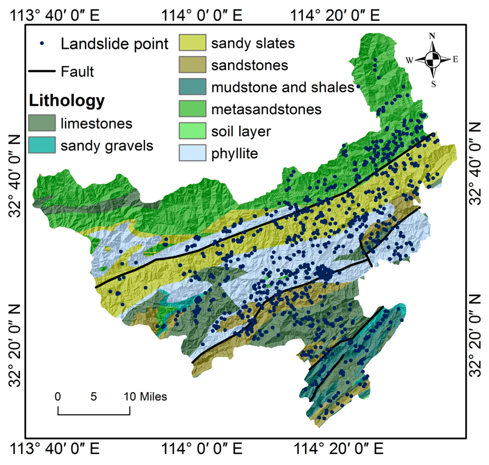
2. Study Area
3. Methodology
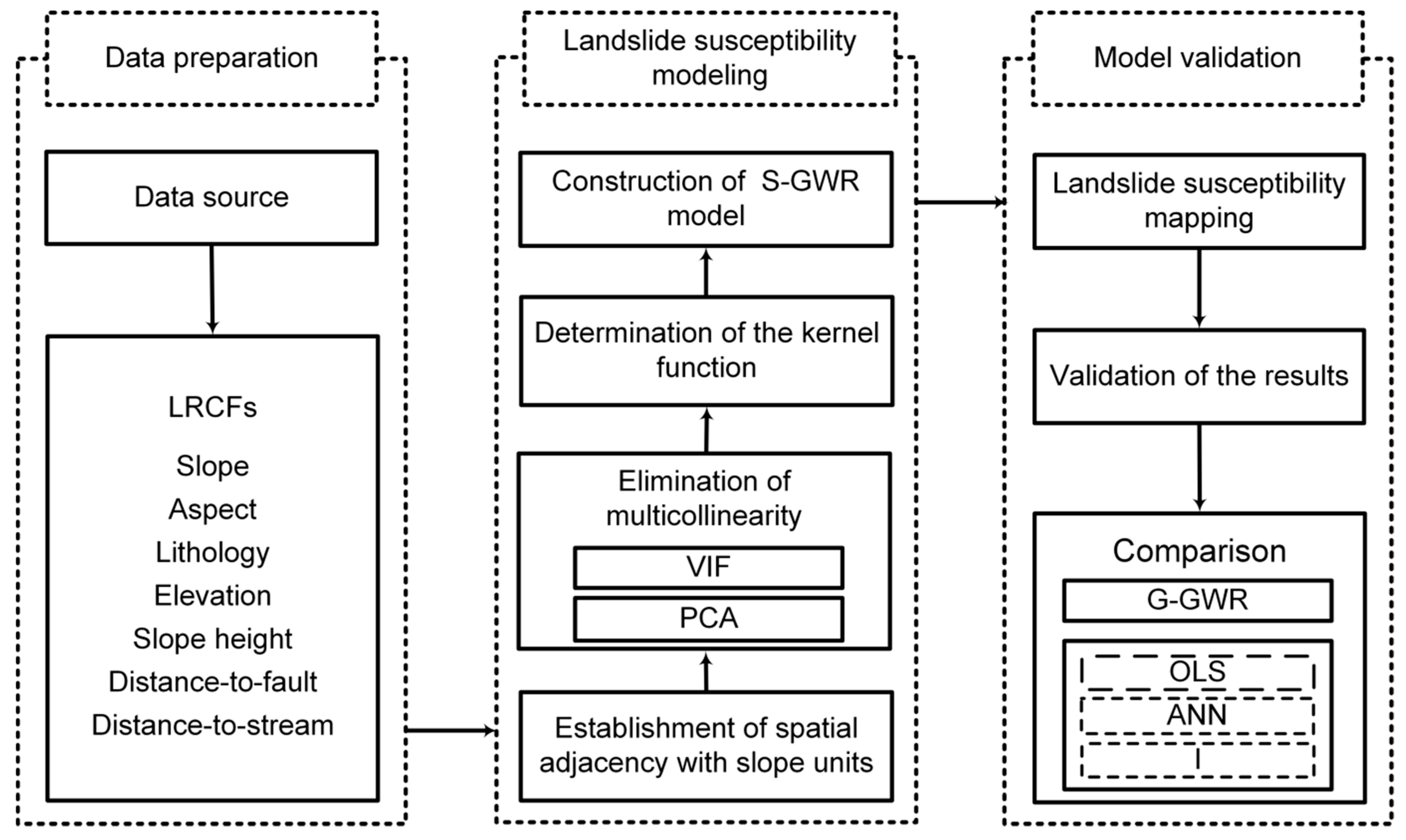
3.1. Flowchart of Research
3.2. Dataset Preparation
3.3. Establishment of Spatial Proximity
3.4. Elimination of Multicollinearity
3.5. GWR Modeling
3.6. Validation Processes
4. Results
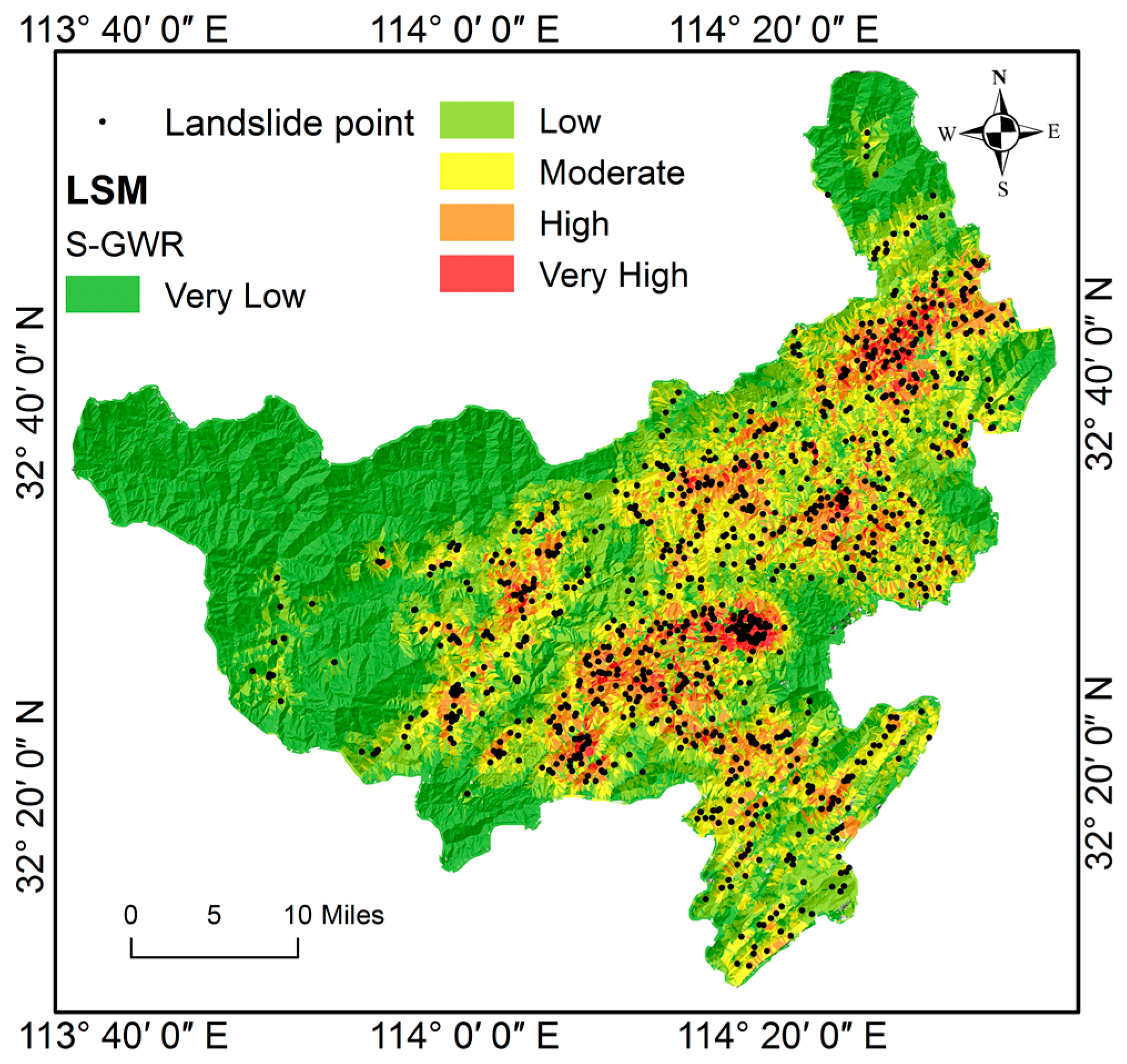
4.1. Landslide Susceptibility Map Using the Proposed Model
4.2. Validation of the S-GWR Models
4.2.1. Validation of the Spatial Non-Stationary
4.2.2. Validation of the Accuracy
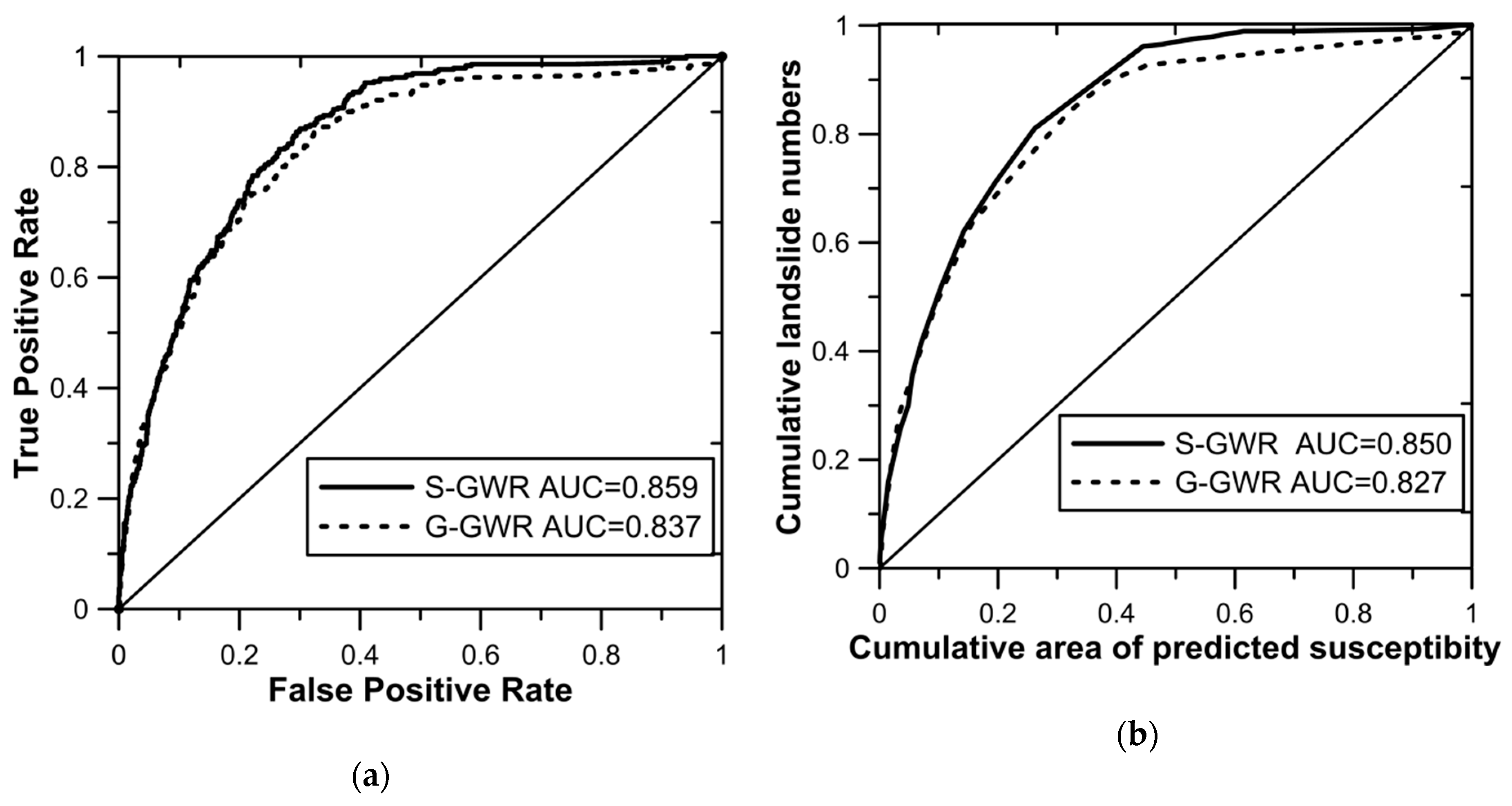
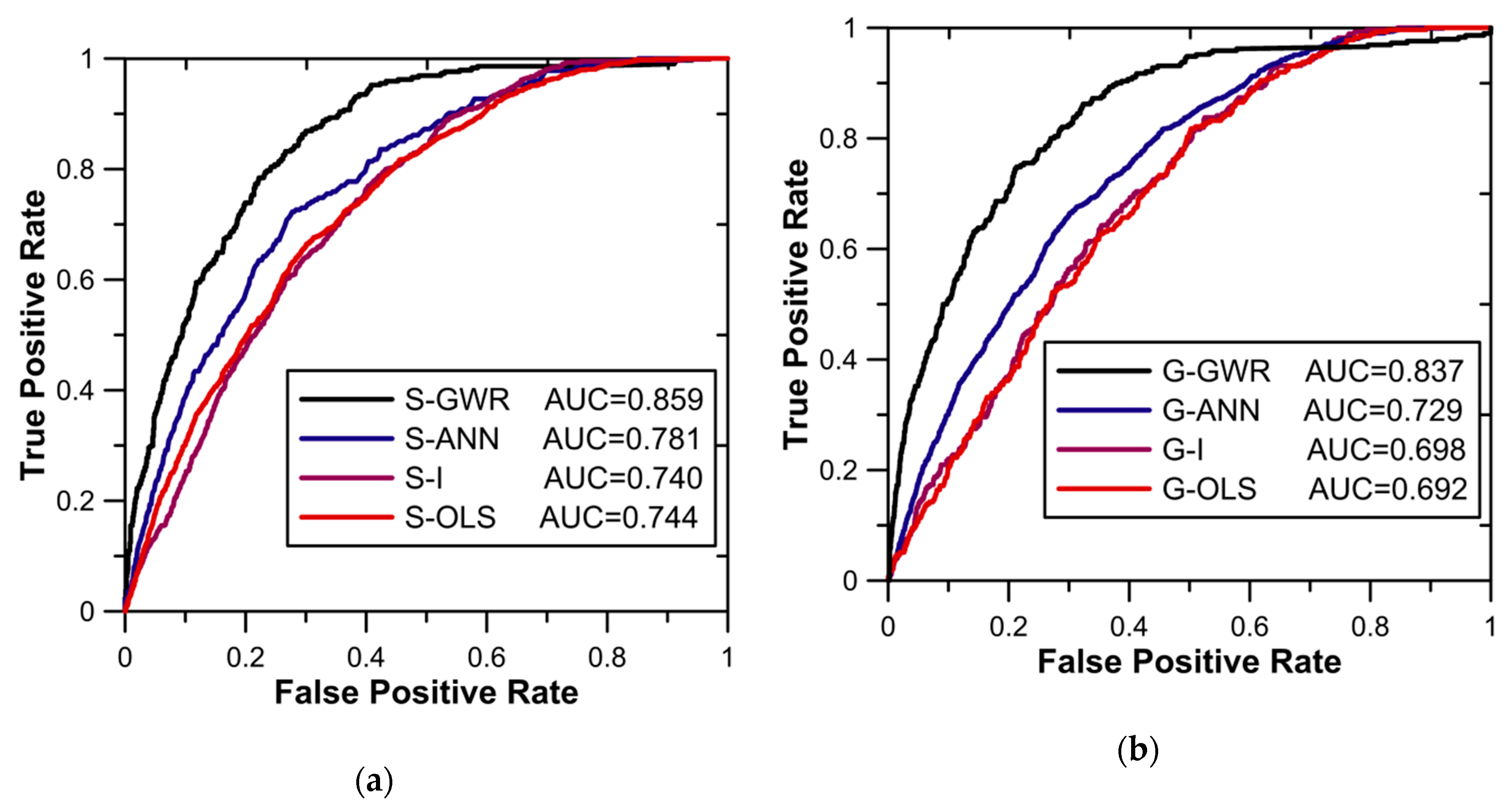
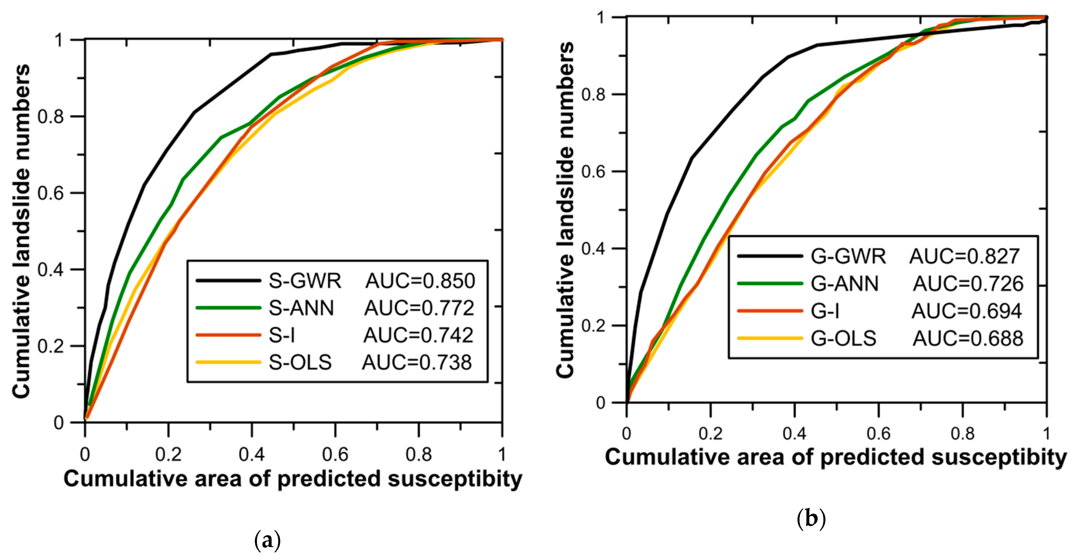
4.3. Comparison with Other Models
4.3.1. Comparison with Grid-Unit-Based GWR (G-GWR)
4.3.2. Comparison with OLS, ANN, and I Models
5. Conclusions
Author Contributions
Funding
Acknowledgments
Conflicts of Interest
References
- Han, Z.; Su, B.; Li, Y.G.; Ma, Y.F.; Wang, W.D.; Chen, G.Q. Comprehensive analysis of landslide stability and related countermeasures: A case study of the Lanmuxi landslide in China. Sci. Rep. 2019, 9, 12407. [Google Scholar] [CrossRef] [PubMed]
- Guha-Sapir, D.; Below, R.; Hoyois, P. EM-DAT: International Disaster Database; Catholic University of Louvain: Brussels, Belgium, 2014; Volume 27. [Google Scholar]
- Pham, B.T.; Pradhan, B.; Bui, D.T.; Prakash, I.; Dholakia, M.B. A comparative study of different machine learning methods for landslide susceptibility assessment: A case study of Uttarakhand area (India). Environ. Model. Softw. 2016, 84, 240–250. [Google Scholar] [CrossRef]
- Pourghasemi, H.R.; Yansari, Z.T.; Panagos, P.; Pradhan, B. Analysis and evaluation of landslide susceptibility: A review on articles published during 2005–2016 (periods of 2005–2012 and 2013–2016). Arab. J. Geosci. 2018, 11, 193–205. [Google Scholar] [CrossRef]
- Jeong, J.S.; Ramírez-Gómez, Á. Optimizing the location of a biomass plant with a fuzzy-DEcision-MAking Trial and Evaluation Laboratory (F-DEMATEL) and multi-criteria spatial decision assessment for renewable energy management and long-term sustainability. J. Clean. Prod. 2018, 182, 509–520. [Google Scholar] [CrossRef]
- Mileu, N.; Queirós, M. Integrating risk assessment into spatial planning: Riskote decision support system. ISPRS Int. J. Geo Inf. 2018, 7, 184. [Google Scholar] [CrossRef]
- Abudeif, A.M.; Moneim, A.A.; Farrag, A.F. Multicriteria decision analysis based on analytic hierarchy process in GIS environment for siting nuclear power plant in Egypt. Ann. Nucl. Energy 2015, 75, 682–692. [Google Scholar] [CrossRef]
- Dou, J.; Yunus, A.P.; Bui, D.T.; Merghadi, A.; Sahana, M.; Zhu, Z.; Chen, C.W.; Han, Z.; Pham, B.T. Improved landslide assessment using support vector machine with bagging, boosting, and stacking ensemble machine learning framework in a mountainous watershed, Japan. Landslides 2019, 1–18. [Google Scholar] [CrossRef]
- Zhu, A.; Pei, T.; Qiao, J.; Chen, Y.; Zhou, C.; Cai, G. A landslide susceptibility mapping approach using expert knowledge and fuzzy logic under GIS. Prog. Geogr. 2006, 25, 1–12. (In Chinese) [Google Scholar] [CrossRef]
- Abella, E.A.C.; Van Westen, C.J. Qualitative landslide susceptibility assessment by multicriteria analysis: A case study from San Antonio del Sur, Guantánamo, Cuba. Geomorphology 2008, 94, 453–466. [Google Scholar] [CrossRef]
- Wu, W.; Sidle, R.C. A distributed slope stability model for steep forested basins. Water Resour. Res. 1995, 31, 2097–2110. [Google Scholar] [CrossRef]
- Montgomery, D.R.; Dietrich, W.E. A physically based model for the topographic control on shallow landsliding. Water Resour. Res. 1994, 30, 1153–1171. [Google Scholar] [CrossRef]
- Hjort, J.; Luoto, M. Statistical methods for geomorphic distribution modeling. Treatise Geomorphol. 2013, 2, 59–73. [Google Scholar] [CrossRef]
- Baeza, C.; Corominas, J. Assessment of shallow landslide susceptibility by means of multivariate statistical techniques. Earth Surf. Proc. Land 2001, 26, 1251–1263. [Google Scholar] [CrossRef]
- O’Sullivan, D. Geographically weighted regression: The analysis of spatially varying relationships. Geogr. Anal. 2003, 35, 272–275. [Google Scholar] [CrossRef]
- Arabameri, A.; Pradhan, B.; Rezaei, K. Gully erosion zonation mapping using integrated geographically weighted regression with certainty factor and random forest models in GIS. J. Environ. Manag. 2019, 232, 928–942. [Google Scholar] [CrossRef]
- Leyk, S.; Norlund, P.U.; Nuckols, J.R. Robust assessment of spatial non-stationarity in model associations related to pediatric mortality due to diarrheal disease in Brazil. Spat. Spatio Temporal Epidemiol. 2012, 3, 95–105. [Google Scholar] [CrossRef]
- Wheeler, D.C.; Páez, A. Geographically weighted regression. Int. Encycl. Hum. Geogr. 2009, 47, 407–414. [Google Scholar] [CrossRef]
- Düzgün, H.S.; Kemeç, S. Spatial and Geographically Weighted Regression; Springer: Boston, MA, USA, 2008. [Google Scholar] [CrossRef]
- Brunsdon, C.; Fotheringham, A.S.; Charlton, M.E. Geographically weighted regression: A method for exploring spatial nonstationarity. Geogr. Anal. 1996, 28, 281–298. [Google Scholar] [CrossRef]
- Páez, A. Exploring contextual variations in land use and transport analysis using a probit model with geographical weights. J. Transp. Geogr. 2006, 14, 167–176. [Google Scholar] [CrossRef]
- Tu, J. Spatially varying relationships between land use and water quality across an urbanization gradient explored by geographically weighted regression. Appl. Geogr. 2011, 31, 376–392. [Google Scholar] [CrossRef]
- Openshaw, S. The Modifiable Areal Unit Problem; Geo Books: Norwich, UK, 1984. [Google Scholar] [CrossRef]
- Wu, S. The Theory and Method of Geographically and Temporally Neural Network Weighted Regression. Ph.D. Thesis, Zhejiang University, Hangzhou, China, 2018. (In Chinese). [Google Scholar]
- Zhang, J.; Zhao, R. Study on the influence factors of housing price in the urban area of Bohai Ring Megalopolis based on geographically weighted regression. Territ. Nat. Resour. Study 2019, 87–93. (In Chinese) [Google Scholar] [CrossRef]
- Sabokbar, H.F.; Roodposhti, M.S.; Tazik, E. Landslide susceptibility mapping using geographically-weighted principal component analysis. Geomorphology 2014, 226, 15–24. [Google Scholar] [CrossRef]
- Ba, Q.; Chen, Y.; Deng, S.; Yang, J.; Li, H. A comparison of slope units and grid cells as mapping units for landslide susceptibility assessment. Earth Sci. Inform. 2018, 11, 373–388. [Google Scholar] [CrossRef]
- Fotheringham, A.S.; Oshan, T.M. Geographically weighted regression and multicollinearity: Dispelling the myth. J. Geogr. Syst. 2016, 18, 1–27. [Google Scholar] [CrossRef]
- Zhang, F. The Discussion on Solutions of Multicollinearity in Multilinear Regression Models. Master’s Thesis, South China University of Technology, Guangzhou, China, 2010. (In Chinese). [Google Scholar]
- Li, G.; Li, R.; Lu, Y.; Zhao, Y.; Yu, B. Using principal component analysis and geographic weighted regression methods to analyze AOD data. Bull. Surv. Mapp. 2018, 493, 50–56. (In Chinese) [Google Scholar] [CrossRef]
- Han, Z.; Li, Y.G.; Du, Y.; Wang, W.D.; Chen, G.Q. Noncontact detection of earthquake-induced landslides by an enhanced image binarization method incorporating with Monte-Carlo simulation. Geomat. Nat. Hazards Risk 2019, 10, 219–241. [Google Scholar] [CrossRef]
- Kawabata, D.; Bandibas, J. Landslide susceptibility mapping using geological data, a DEM from ASTER images and an Artificial Neural Network (ANN). Geomorphology 2009, 113, 97–109. [Google Scholar] [CrossRef]
- Li, Y.; Chen, G.; Tang, C.; Zheng, L. Rainfall and earthquake-induced landslide susceptibility assessment using GIS and Artificial Neural Network. Nat. Hazards Earth Syst. Sci. 2012, 12, 2719–2729. [Google Scholar] [CrossRef]
- Pradhan, B. A comparative study on the predictive ability of the decision tree, support vector machine and neuro-fuzzy models in landslide susceptibility mapping using GIS. Comput. Geosci. 2012, 51, 350–365. [Google Scholar] [CrossRef]
- Khan, H.; Shafique, M.; Khan, M.A.; Bacha, M.A.; Shah, S.U.; Calligaris, C. Landslide susceptibility assessment using Frequency Ratio, a case study of northern Pakistan. Egypt. J. Remote Sens. Space Sci. 2019, 22, 11–24. [Google Scholar] [CrossRef]
- Suh, J.; Choi, Y.; Roh, T.D.; Lee, H.J.; Park, H.D. National-scale assessment of landslide susceptibility to rank the vulnerability to failure of rock-cut slopes along expressways in Korea. Environ. Earth Sci. 2011, 63, 619–632. [Google Scholar] [CrossRef]
- Zhuang, J.; Peng, J.; Iqbal, J.; Liu, T.; Liu, N.; Li, Y.; Ma, P. Identification of landslide spatial distribution and susceptibility assessment in relation to topography in the Xi’ an Region, Shaanxi Province, China. Front. Earth Sci. 2015, 9, 449–462. [Google Scholar] [CrossRef]
- Kamp, U.; Growley, B.J.; Khattak, G.A.; Owen, L.A. GIS-based landslide susceptibility mapping for the 2005 kashmir earthquake region. Geomorphology 2008, 101, 631–642. [Google Scholar] [CrossRef]
- Rossoni, L.; Engelbert, R.; Bellegard, N.L. Normal science and its tools: Reviewing the effects of factor analysis in management. Rev. Adm. 2016, 51, 198–211. [Google Scholar] [CrossRef]
- Zheng, W.; Xu, W.; Tong, F.; Shi, A. 3D geological visualization and numerical modeling of complicated slope. Chin. J. Rock Mech. Eng. 2007, 26, 1633–1644. (In Chinese) [Google Scholar]
- Su, S.; Gong, Y.; Tan, B.; Pi, J.; Weng, M.; Cai, Z. Area social deprivation and public health: Analyzing the spatial non-stationary associations using geographically weighed regression. Soc. Indic. Res. 2016, 133, 819–832. [Google Scholar] [CrossRef]
- Yan, G.; Liang, S.; Zhao, H. Improvement and implementation of slope element partitioning method based on GIS. Sci. Geogr. Sin. 2017, 37, 1764–1770. (In Chinese) [Google Scholar] [CrossRef]
- Qin, W. The Basic Theoretics and Application Research on Geographically Weighted Regression. Ph.D. Thesis, Tongji University, Shanghai, China, 2007. [Google Scholar]
- Zhang, L.; Yang, Y.; Liang, X. The diagnostic approach of multicollinearity in geographically weighted regression model. Geomat. Spat. Inf. Technol. 2017, 40, 28–31. (In Chinese) [Google Scholar]
- Guzzetti, F.; Reichenbach, P.; Ardizzone, F.; Cardinali, M.; Galli, M. Estimating the quality of landslide susceptibility models. Geomorphology 2006, 81, 166–184. [Google Scholar] [CrossRef]
- Qiu, H. Study on the Regional Landslide Characteristic Analysis and Hazard Assessment: A Case Study of Ningqiang County. Ph.D. Thesis, Northwest University, Xian, China, 2012. [Google Scholar]
- Goetz, J.N.; Guthrie, R.H.; Brenning, A. Integrating physical and empirical landslide susceptibility models using generalized additive models. Geomorphology 2011, 129, 376–386. [Google Scholar] [CrossRef]
- Jenks, G. Optimal Data Classification for Choropleth Maps. Ph.D. Thesis, University of Kansas, Kansas, KS, USA, 1977. [Google Scholar]
- Akbar, T.A.; Ha, S.R. Landslide hazard zoning along Himalayan Kaghan Valley of Pakistan-by integration of GPS, GIS, and remote sensing technology. Landslides 2011, 8, 527–540. [Google Scholar] [CrossRef]


| Criteria | Former Studies Using the Same Criterion for Landslide Susceptibility Assessment |
|---|---|
| Elevation | Kawabata et al. (2009) [32], Li et al. (2012) [33], Sabokbar et al. (2014) [26], Pradhan. (2013) [34], HawasKhan et al. (2019) [35] |
| Slope | Kawabata et al. (2009) [32], Li et al. (2012) [33], Sabokbar et al. (2014) [26], Pradhan. (2013) [34], HawasKhan et al. (2019) [35], Suh et al. (2019) [36], Zhuang et al. (2012) [37] |
| Slope height | Li et al. (2012) [33], Suh et al. (2019) [36], Zhuang et al. (2012) [37] |
| Aspect | Kawabata et al. (2009) [32], Li et al. (2012) [33], Sabokbar et al. (2014) [26], HawasKhan et al. (2019) [35], Zhuang et al. (2012) [37] |
| Distance-to-stream | Li et al. (2012) [33], Sabokbar et al. (2014) [26], Pradhan. (2013) [34], HawasKhan et al. (2019) [35] |
| Distance-to-fault | Li et al. (2012) [33], Sabokbar et al. (2014) [26], HawasKhan et al. (2019) [35], Suh et al. (2019) [36] |
| Lithology | Kawabata et al. (2009) [32], Li et al. (2012) [33], Sabokbar et al. (2014) [26], Pradhan. (2013) [34], HawasKhan et al. (2019) [35], Suh et al. (2019) [36] |
| Influencing Factors | VIF |
|---|---|
| Slope | 1.61 |
| Aspect | 1.06 |
| Elevation | 1.88 |
| Slope height | 1.52 |
| Lithology | 1.35 |
| Distance-to-fault | 1.87 |
| Distance-to-stream | 1.12 |
| Principal Components | PC1 | PC2 | PC3 | PC4 |
|---|---|---|---|---|
| Slope | 0.128 | 0.858 | 0.047 | 0.133 |
| Aspect | 0.038 | 0.132 | 0.055 | 0.981 |
| Elevation | 0.675 | 0.374 | 0.374 | −0.007 |
| Slope height | 0.106 | 0.861 | −0.152 | −0.010 |
| Lithology | 0.829 | −0.030 | −0.195 | 0.108 |
| Distance-to-fault | 0.860 | 0.122 | 0.110 | −0.066 |
| Distance-to-stream | 0.070 | −0.106 | 0.939 | 0.055 |
| Accumulative loadings | 2.706 | 2.211 | 1.178 | 1.194 |
| Predicted Groups (Model) | |||
|---|---|---|---|
| Stable | Unstable | ||
| Actual Groups (inventory) | Stable | 11,881 (72.43%) | 4523 (27.57%) |
| Unstable | 36 (12.37%) | 255 (87.63%) | |
| Influencing Factors | VIF |
|---|---|
| Slope | 1.02 |
| Aspect | 1.83 |
| Elevation | 2.05 |
| Slope height | 2.00 |
| Lithology | 2.14 |
| Distance-to-fault | 1.10 |
| Distance-to-stream | 1.36 |
| Predicted Groups (Model) | |||
|---|---|---|---|
| Stable | Unstable | ||
| Actual groups (inventory) | Stable | 13,449 (78.20%) | 3750 (21.80%) |
| Unstable | 61 (20.96%) | 230 (79.04%) | |
© 2020 by the authors. Licensee MDPI, Basel, Switzerland. This article is an open access article distributed under the terms and conditions of the Creative Commons Attribution (CC BY) license (http://creativecommons.org/licenses/by/4.0/).
Share and Cite
Li, Y.; Liu, X.; Han, Z.; Dou, J. Spatial Proximity-Based Geographically Weighted Regression Model for Landslide Susceptibility Assessment: A Case Study of Qingchuan Area, China. Appl. Sci. 2020, 10, 1107. https://doi.org/10.3390/app10031107
Li Y, Liu X, Han Z, Dou J. Spatial Proximity-Based Geographically Weighted Regression Model for Landslide Susceptibility Assessment: A Case Study of Qingchuan Area, China. Applied Sciences. 2020; 10(3):1107. https://doi.org/10.3390/app10031107
Chicago/Turabian StyleLi, Yange, Xintong Liu, Zheng Han, and Jie Dou. 2020. "Spatial Proximity-Based Geographically Weighted Regression Model for Landslide Susceptibility Assessment: A Case Study of Qingchuan Area, China" Applied Sciences 10, no. 3: 1107. https://doi.org/10.3390/app10031107
APA StyleLi, Y., Liu, X., Han, Z., & Dou, J. (2020). Spatial Proximity-Based Geographically Weighted Regression Model for Landslide Susceptibility Assessment: A Case Study of Qingchuan Area, China. Applied Sciences, 10(3), 1107. https://doi.org/10.3390/app10031107