Evaluation of Damages to the Architectural Heritage of Naples as a Result of the Strongest Earthquakes of the Southern Apennines

 ,
,  ,
, 
Abstract
1. Introduction
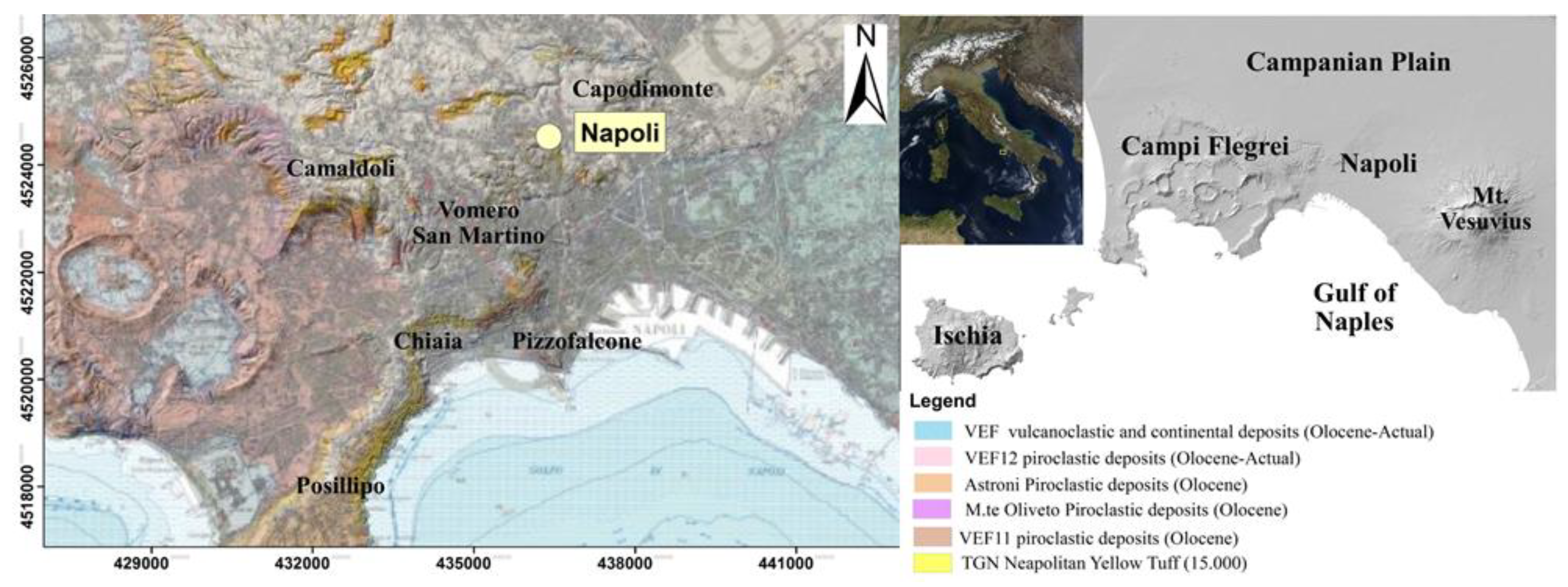
2. Methodology
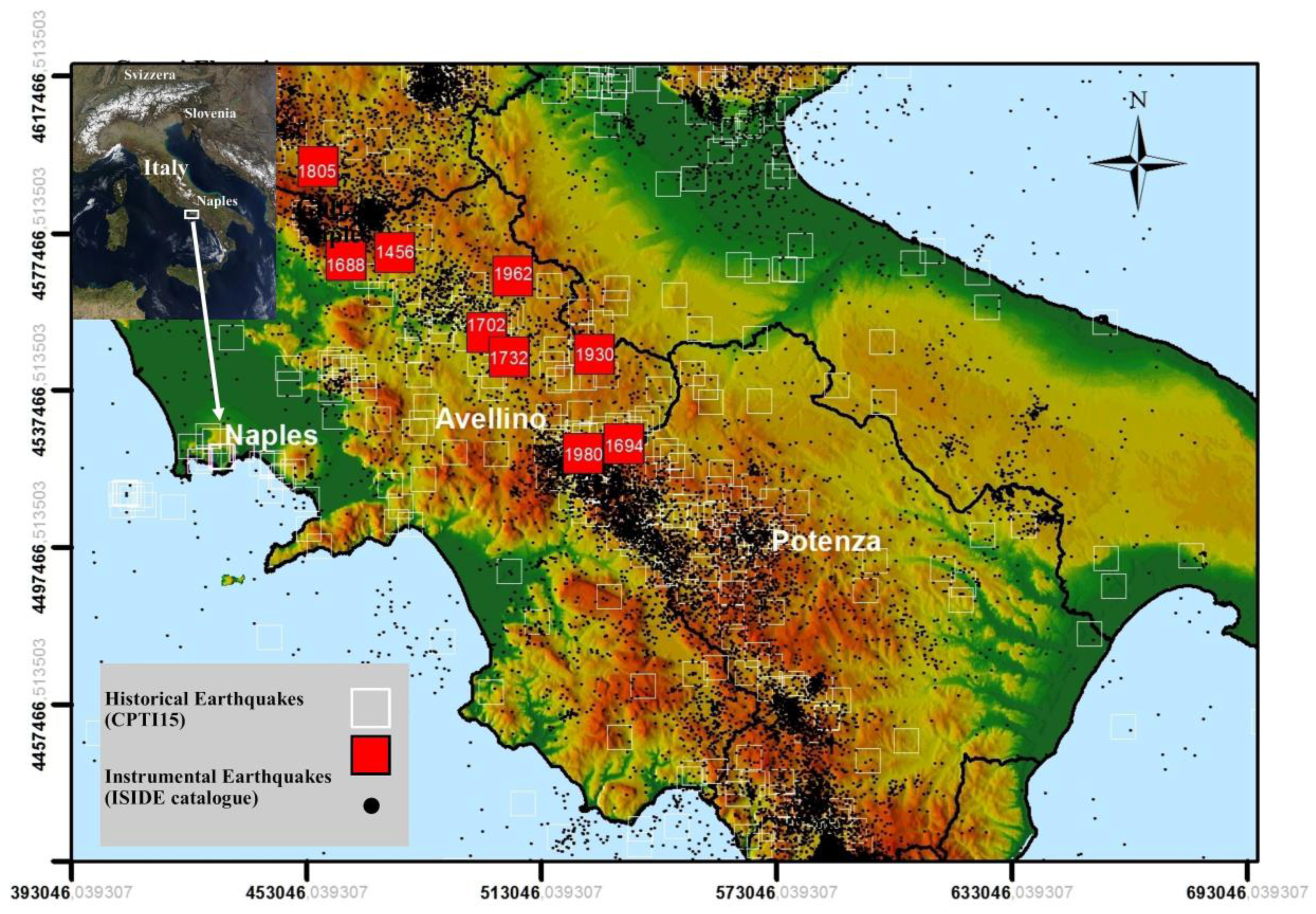
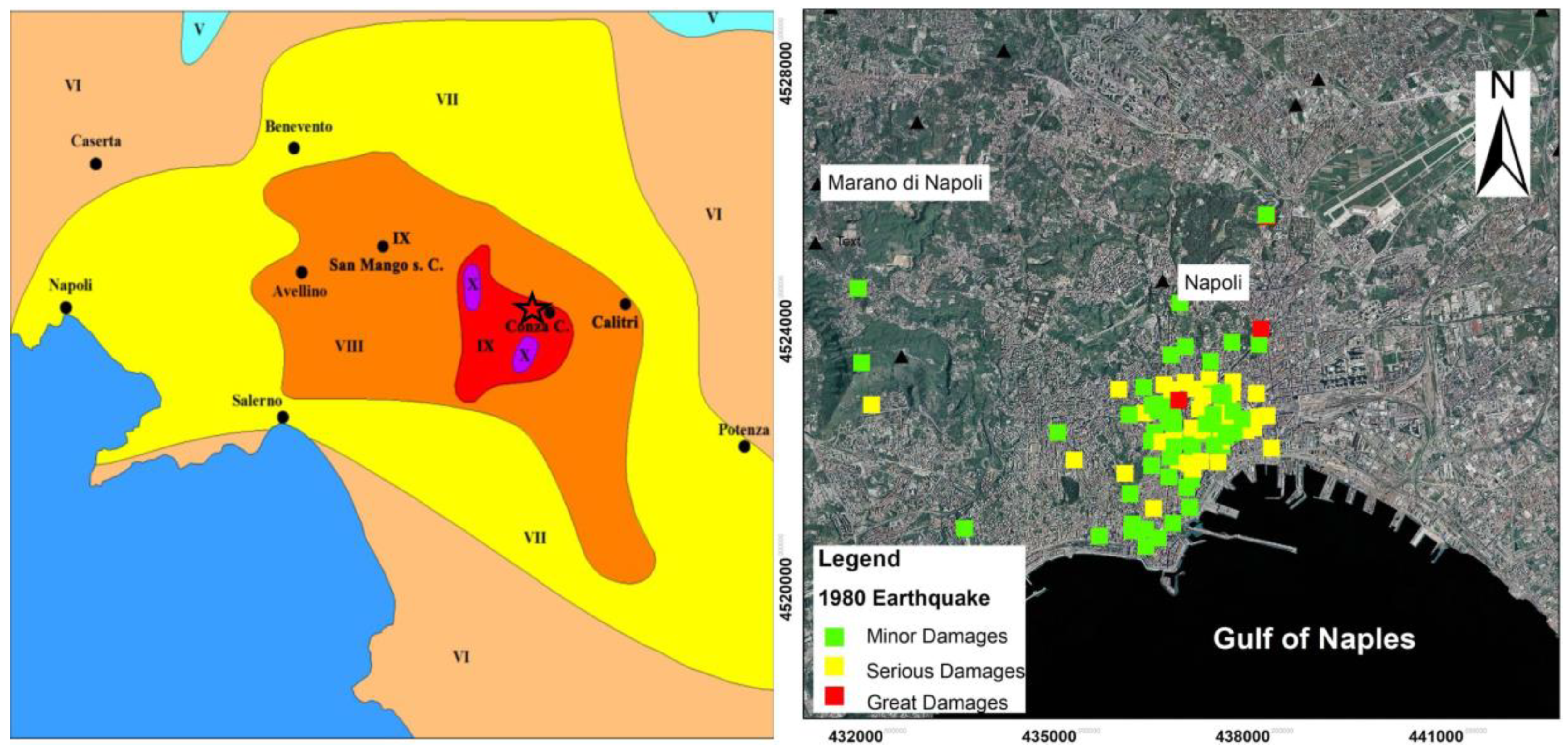
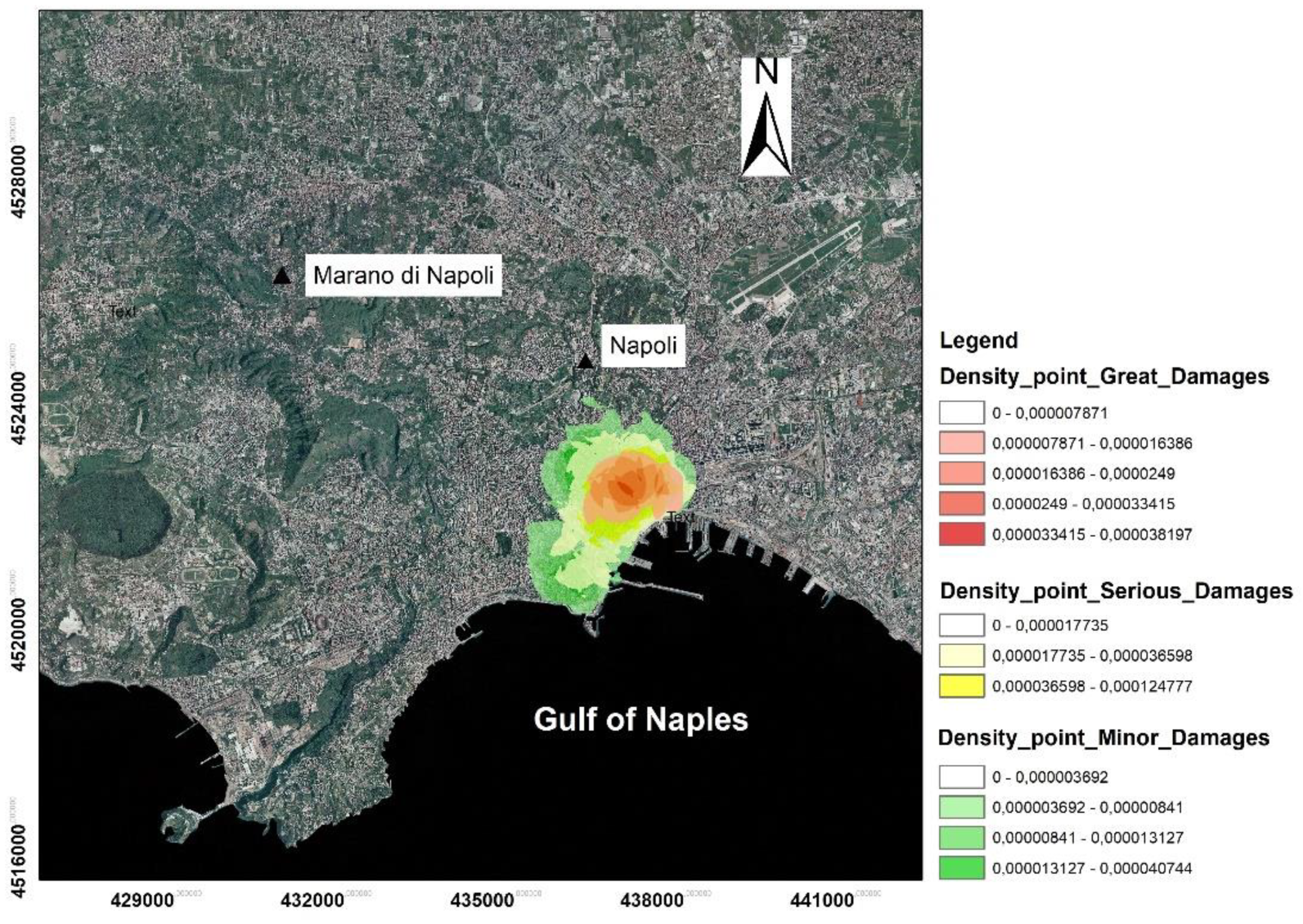
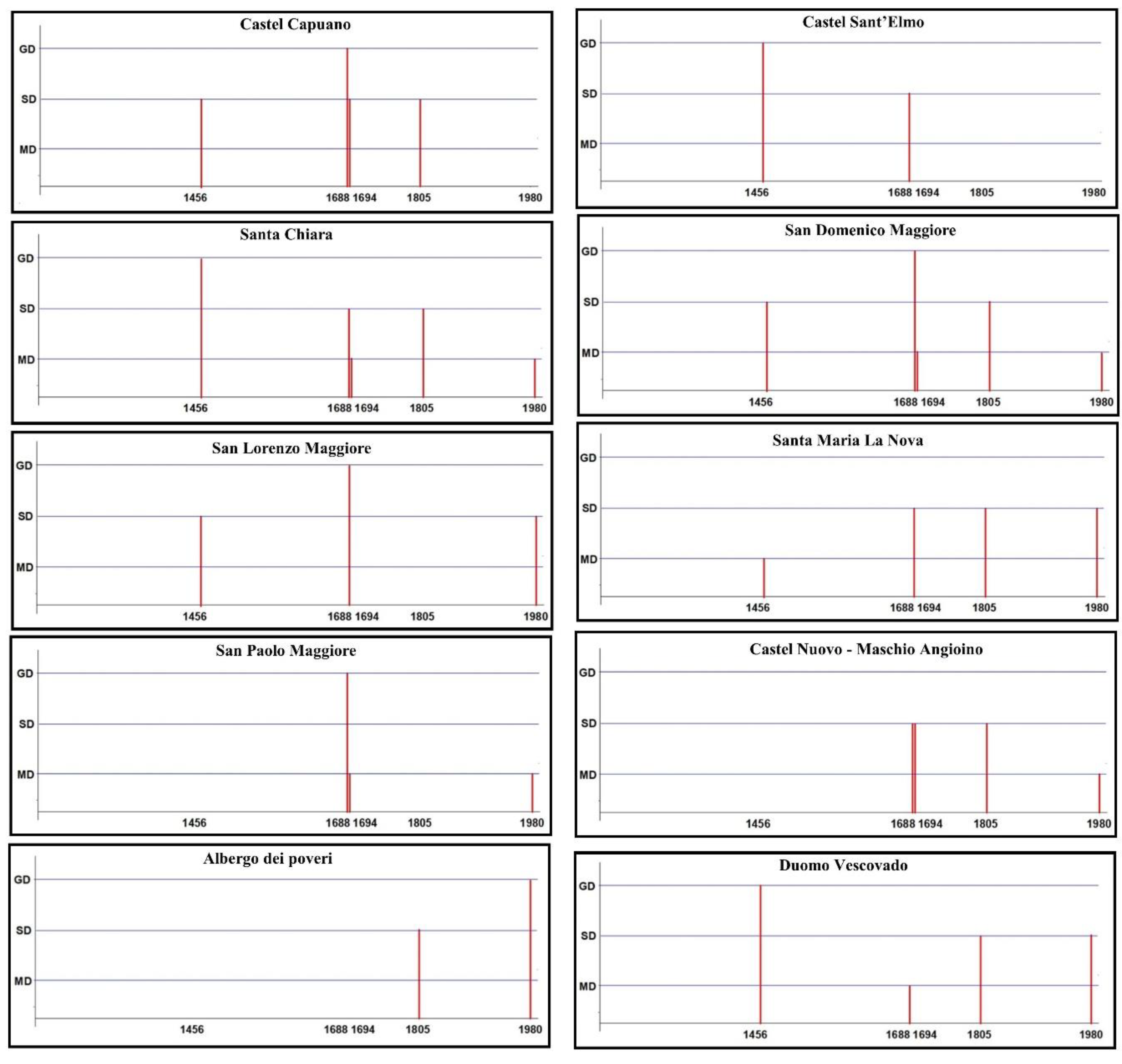
3. Historical Earthquakes of the Southern Apennines Felt in Naples
4. Results and Discussion
5. Conclusions
Author Contributions
Funding
Acknowledgments
Conflicts of Interest
Appendix A

| Date | Epicentral Area | I0 | Mw | I Naples | References |
|---|---|---|---|---|---|
| 1293 09 04 | Sannio-Matese | 8–9 | 5.80 | 7 | 1 |
| 1349 09 09 | Lazio-Molise | 10 | 6.80 | 7–8 | 1 |
| 1386 03 17 | Napoli | 7–8 | 3.75 | 7–8 | 1 |
| 1406 09 16 | Napoli | 5 | 3.12 | 5 | 1 |
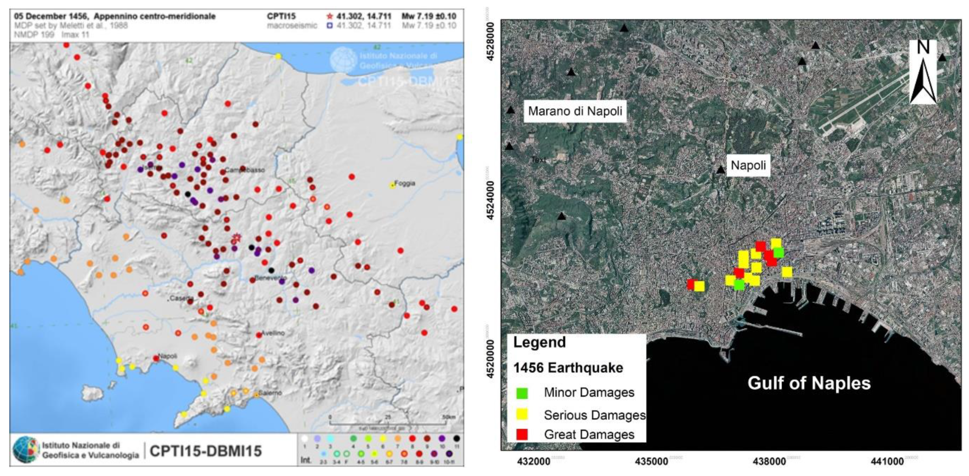
| 1456 12 05 | Appennino centro-meridionale | 11 | 7.19 | 8 | 1 |
| 1456 12 30 08 20 | Appennino centro-meridionale | 7 | 1 | ||
| 1457 01 08 | Napoli | 6 | 3.37 | 6 | 1 |
| 1457 02 10 | Capua | 5–6 | 4.40 | 3 | 1 |
| 1466 01 15 02 25 | Irpinia-Basilicata | 8–9 | 5.98 | 5 | 1 |
| 1468 05 26 | Napoli | 4 | 4 | 10 | |
| 1470 01–1472 09 | Pozzuoli | 7 | 10 | ||
| 1475 08 11 | Napoli | 4–5 | 4–5 | 10 | |
| 1496 11 09 | Napoli | 4 | 4 | 10 | |
| 1498 10 07 | Campi Flegrei (Pozzuoli) | 5–6 | 3.25 | 5 | 1; 10 |
| 1498 10 19 | Campi Flegrei (Pozzuoli) | 5–6 | 5 | 10 | |
| 1498 10 20 | Campi Flegrei (Pozzuoli) | 7 | 3.63 | 3 | 1; 10 |
| 1499 03 18 00 45 | Napoli | 4–5 | 4–5 | 10 | |
| 1499 03 18 01 45 | Napoli | 5 | 3.12 | 5 | 1; 10 |
| 1505 05 18 08 55 | Campi Flegrei (Agnano) | 8 [5) | 3.75 | 6 | 1; 10 |
| 1508 01 25 15 20 | Napoli | 4–5 | 4–5 | 10 | |
| 1508 04 25 | Pozzuoli | 8 | 10 | ||
| 1508 07 19 08 55 | Napoli | 5 | 3.12 | 5 | 1; 10 |
| 1517 03 29 19 | Irpinia | 7–8 | 5.33 | 5 | 1 |
| 1520 01 28 23 50 | Campi Flegrei (Pozzuoli) | 6–7 | 3.50 | 5 | 1; 10 |
| 1536 08 07 | Napoli | 5 | 3.12 | 5 | 1; 10 |
| 1537 02 14 | Campi Flegrei (Pozzuoli) | 7–8 [5) | 3.50 | 4 | 1; 10 |
| 1538 04 20 | Napoli | 6 [5) | 3.25 | 6 | 1; 10 |
| 1538 09 20 | Campi Flegrei (Pozzuoli) | 5–6 | 3.25 | 4 | 1; 10 |
| 1538 09 22 | Campi Flegrei (Pozzuoli) | 5–6 | 3.25 | 4 | 1; 10 |
| 1538 09 23 | Campi Flegrei (Pozzuoli) | 5–6 | 3.25 | 4 | 1; 10 |
| 1538 09 24 | Campi Flegrei (Pozzuoli) | 5–6 | 3.25 | 4 | 1; 10 |
| 1538 09 25 | Campi Flegrei (Pozzuoli) | 5–6 | 3.25 | 4 | 1; 10 |
| 1538 09 26 | Campi Flegrei (Pozzuoli) | 5–6 | 3.25 | 4 | 1; 10 |
| 1538 09 27 | Campi Flegrei (Pozzuoli) | 5–6 | 3.25 | 4 | 1; 10 |
| 1538 09 28 06 00 | Campi Flegrei (Pozzuoli) | 5–6 | 3.25 | 4 | 1; 10 |
| 1538 09 28 17 30 | Campi Flegrei (Pozzuoli) | 5–6 | 3.25 | 4 | 1; 10 |
| 1538 09 29 11 00 | Campi Flegrei (Pozzuoli) | 5–6 | 3.25 | 4 | 1; 10 |
| 1538 09 29 18 30 (eruption) | Campi Flegrei (Pozzuoli) | 8 | 3.88 | 5 | 1; 10 |
| 1560 05 11 04 40 | Costa Pugliese centrale | 8 | 5.66 | 3 | 1 |
| 1561 07 31 20 10 | Penisola sorrentina | 8 | 5.56 | 7 | 1 |
| 1561 08 19 15 50 | Vallo di Diano | 10 | 6.72 | 4-5 | 1 |
| 1564 07 | Campi Flegrei | 4–5 (5) | 3.12 | 5–6 | 1; 10 |
| 1566 05 06 22 45 | Napoli | 5 | 3.12 | 5–6 [5) | 1; 10 |
| 1568 12 27 | Campi Flegrei (Pozzuoli) | 6 | 3.37 | 4-5 | 1; 10 |
| 1570 04 30 23 06 | Campi Flegrei (Pozzuoli) | 6–7 | 3.50 | 5 | 1; 10 |
| 1570 06 17 | Pozzuoli | 4–5 | 4 | 10 | |
| 1575 06 05 20 30 | Napoli | 5–6 | 3.25 | 6–7 | 1 |
| 1580 06 09 07 10 | Campi Flegrei (Pozzuoli) | 4–5 | 4 | 10 | |
| 1582 06 05 07 08 | Campi Flegrei (Pozzuoli) | 8 | 3.88 | 5 | 1; 10 |
| 1601 08 10 UT | Napoli | 5 | 3.12 | 5 | 1 |
| 1616 01 12 20 20 UT | Napoli | 5 | - | 5 | 8 |
| 1616 12 07/08 20 05 UT | Napoli | 5 | 5 | 8 | |
| 1620 03 20 UT | Napoli | 5 | 5 | 8 | |
| 1621 08 10 00 40 UT | Napoli | 5 | 5 | 8 | |
| 1622 02 25 05 40 UT | Napoli | 5 | 5 | 8 | |
| 1622 04 10 UT | Napoli | 5 | 5 | 8 | |
| 1622 11 06 18 55 UT | Napoli | 5 | 5 | 8 | |
| 1622 11 06 21 25UT | Napoli | 4 | 4 | 8 | |
| 1626 03 10 00 40 UT | Napoli | 6–7 | 6–7 | 8 | |
| 1626 03 10 22 15 UT | Napoli | 4 | 4 | 8 | |
| 1626 03 15 19 05 UT | Napoli | 4 | 4 | 8 | |
| 1626 03 22 05 15 UT | Napoli | 3 | 3 | 8 | |
| 1626 09 08 04 55 UT | Napoli | 3 | 3 | 8 | |
| 1626 10 21 13 45 UT | Napoli | 3 | 3 | 8 | |
| 1626 10 27 12 40 UT | Napoli | 3 | 3 | 8 | |
| 1626 11 02 23 15 UT | Napoli | 4 | 4 | 8 | |
| 1627 07 30 10 50 | Capitanata | 10 | 6.66 | 5 | 1 |
| 1630 04 02 06 50 UT | Napoli | 5 | 5 | 8 | |
| 1631 12 | Area Vesuviana | 5–6 | 3.25 | 5–6 | 1 |
| 1631 12 15 21UT | Area Vesuviana | 5–6 | 3 | 8 | |
| 1631 12 15 23UT | Area Vesuviana | 7 | 8 | ||
| 1631 12 17 | Area Vesuviana | 7 | 5.17 | 4 | |
| 1638 03 27 15 05 | Calabria centrale | 11 | 7.09 | 3 | 1 |
| 1646 05 31 | Gargano | 10 | 6.72 | 5 | 1 |
| 1657 01 29 02 | Capitanata | 8–9 | 5.96 | 4–5 | 1 |
| 1685 05 | Penisola Sorrentina | 5–6 | 4.73 | 5 | 1 |
| 1687 04 25 00 30 | Penisola Sorrentina | 6 | 4.63 | 5 | 1 |
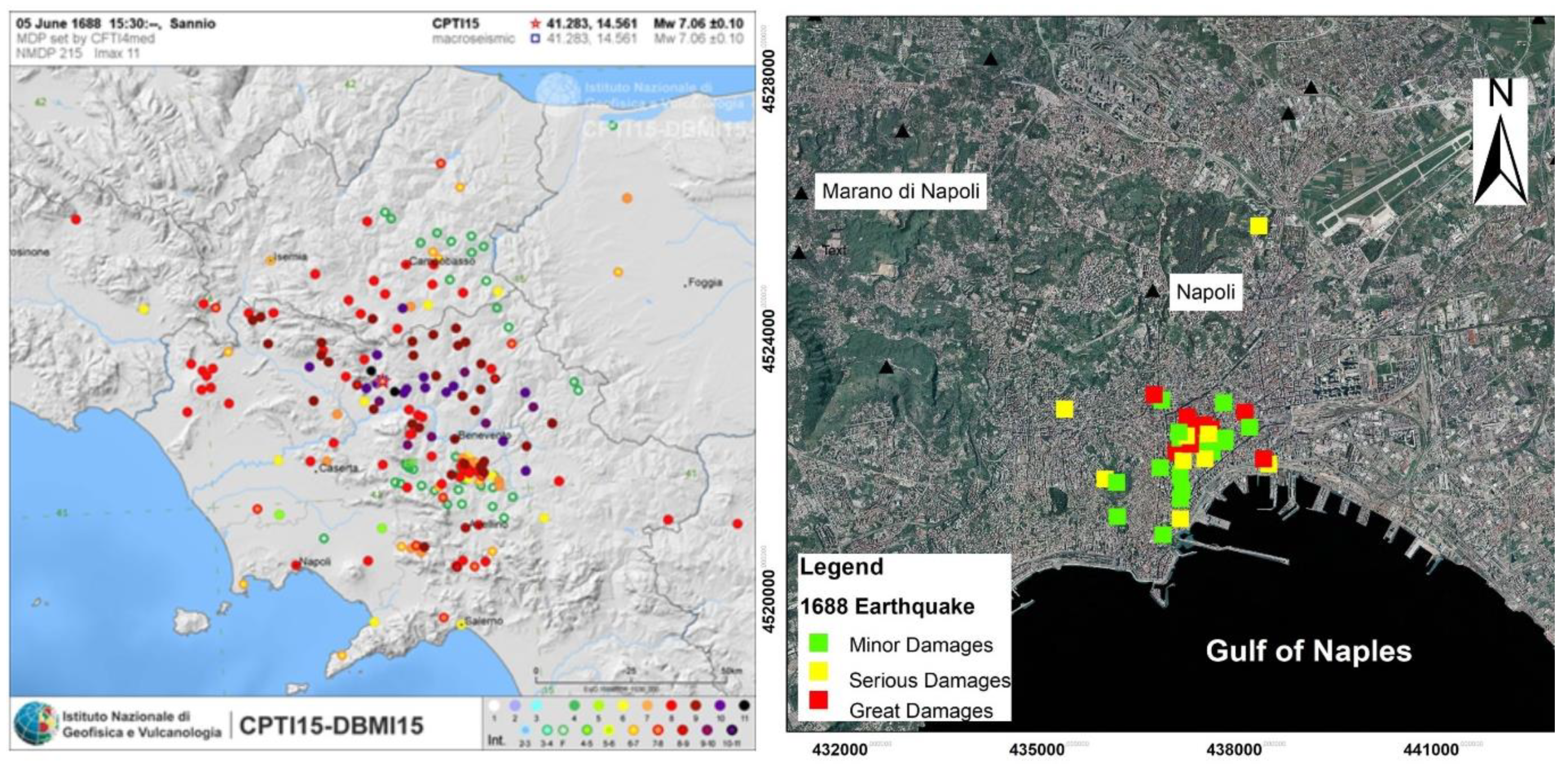
| 1688 06 05 15 30 | Sannio | 11 | 7.06 | 8 | 1 |
| 1688 07 23 | Capitanata | 7–8 | 5.33 | 3 | 1 |
| 1688 08 14 | Beneventano | 6–7 | 4.86 | 3 | 1 |
| 1692 03 04 22 20 | Irpinia | 8 | 5.88 | 5 | 1 |
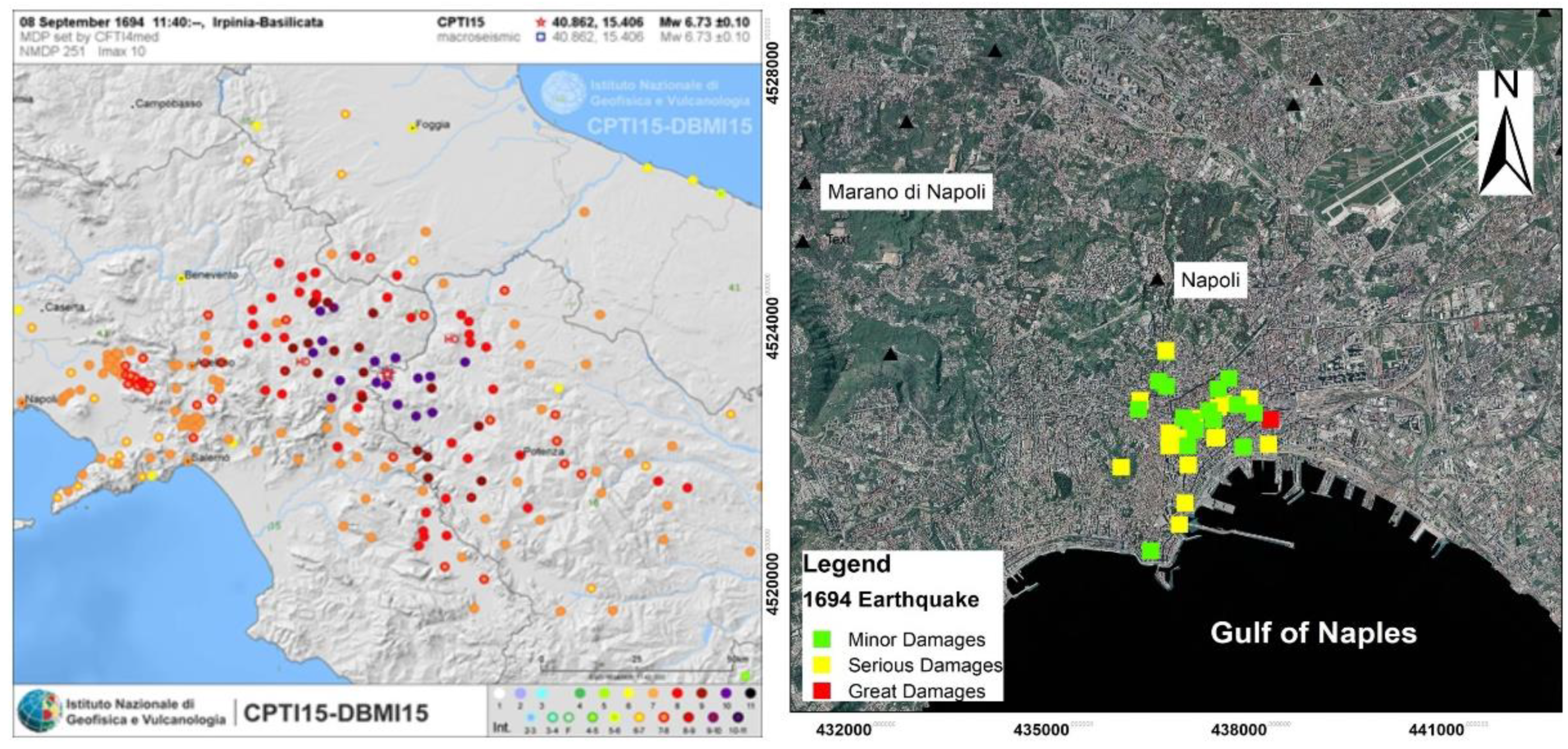
| 1694 09 08 11 40 | Irpinia-Basilicata | 10 | 6.73 | 7 | 1 |
| 1694 10 09 | Avellino | 5–6 | 4.40 | 3 | 1 |
| 1702 03 14 04 30 | Sannio-Irpinia | 6–7 | 4.86 | 5 | 1 |
| 1702 03 14 05 | Sannio-Irpinia | 10 | 6.56 | 6 | 1 |
| 1702 04 02 06 20 | Sannio-Irpinia | 6–7 | 4.86 | 4–5 | 1 |
| 1703 01 14 18 | Valnerina | 11 | 6.92 | 3–4 | 1 |
| 1703 01 16 13 30 | Appennino laziale-abruzzese | 3 | 1 | ||
| 1703 02 02 11 05 | Aquilano | 10 | 6.67 | 3 | 1 |
| 1706 11 03 13 | Maiella | 10–11 | 6.84 | 4–5 | 1 |
| 1720 08 28 | Cassinese | 5-6 | 4.35 | 5 | 1 |
| 1731 03 20 03 | Tavoliere delle Puglie | 9 | 6.33 | 5 | 1 |
| 1731 10 17 11 | Tavoliere delle Puglie | 6–7 | 4.86 | 4–5 | 1 |
| 1732 11 29 07 40 | Irpinia | 10–11 | 6.75 | 7 | 1 |
| 1733 05 15 00 30 | Puglia | 3 | 1 | ||
| 1735 01 26 | Casertano | 5 | 4.16 | 3–4 | 1 |
| 1737 03 31 17 20 | Monti di Avella | 7 | 5.10 | 4 | 1 |
| 1739 02 12 21 30 | Tavoliere delle Puglie | 5–6 | 4.40 | 3 | 1 |
| 1739 02 27 04 20 | Benevento | 5–6 | 4.40 | 4 | 1 |
| 1741 08 06 13 30 | Irpinia | 7–8 | 5.44 | 4 | 1 |
| 1742 08 17 | Napoli | 5–6 | 3.25 | 5–6 | 1 |
| 1743 02 20 | Ionio settentrionale | 9 | 6.68 | 4–5 | 1 |
| 1756 10 22 14 | Napoletano | 6–7 | 3.50 | 6–7 | 1 |
| 1760 12 23 | Area vesuviana | 6–7 | 3.50 | 4–5 | 1 |
| 1777 06 06 16 15 | Tirreno meridionale | 4–5 | 1 | ||
| 1779 10 01 00 45 | Napoletano | 6 | 3.37 | 4 | 1 |
| 1779 12 12 | Napoletano | 6 | 3.37 | 3 | 1 |
| 1783 03 28 18 55 | Calabria centrale | 11 | 7.03 | 4 | 1 |
| 1794 06 12 22 30 | Irpinia | 7 | 5.26 | 5 | 1 |
| 1794 06 15 | Area vesuviana | 4 | 2.87 | 3 | 1 |
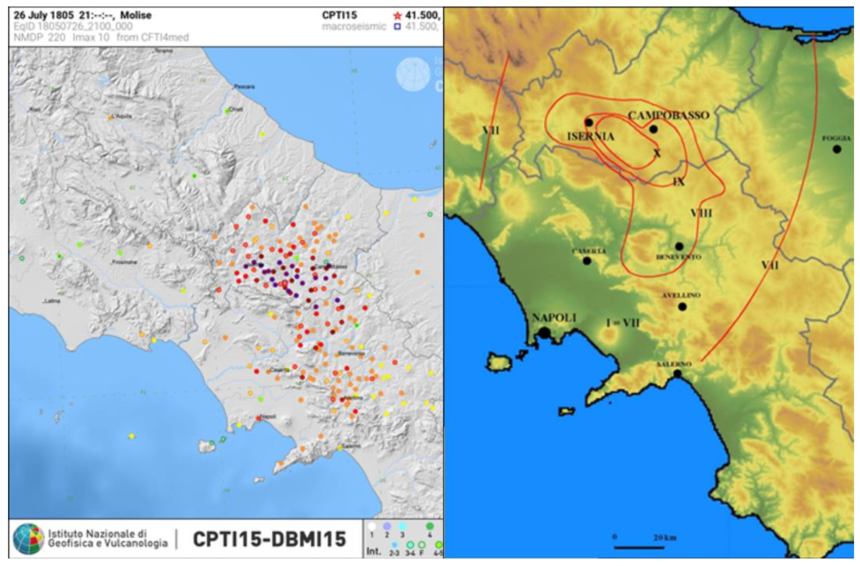
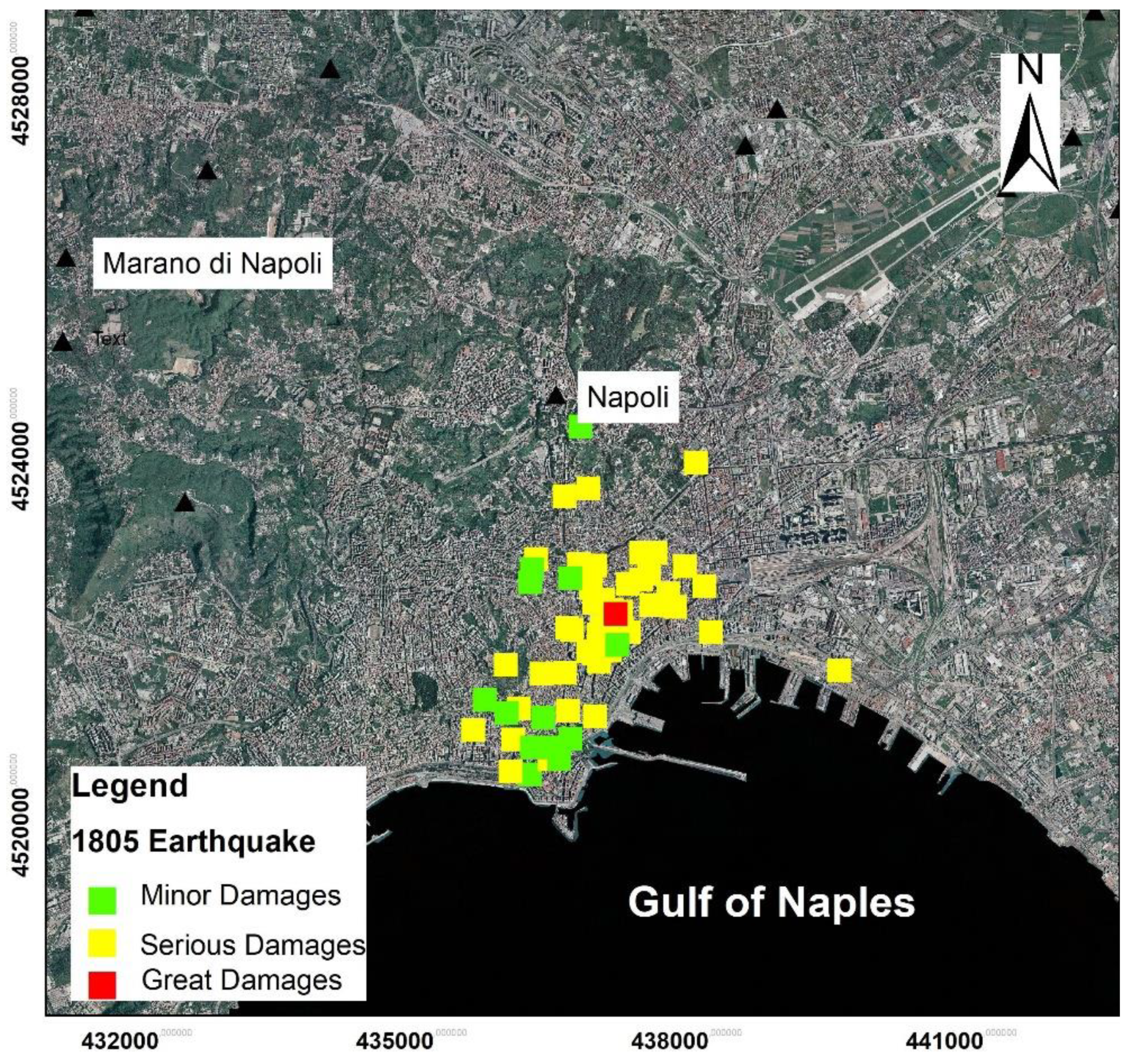
| 1805 07 26 21 | Molise | 10 | 6.68 | 7–8 | 1 |
| 1805 10 13 22 | Pianura Campana | 7 | 5.10 | 3 | 1 |
| 1806 08 26 07 35 | Colli Albani | 8 | 5.61 | 3–4 | 1 |
| 1814 11 25 | Beneventano | 5–6 | 4.40 | 3 | 1 |
| 1817 04 17 | Potentino | 4–5 | 3.97 | 3 | 1 |
| 1821 11 22 01 15 | Costa molisana | 7–8 | 5.59 | 3 | 1 |
| 1826 02 01 16 | Potentino | 8 | 5.74 | 3 | 1 |
| 1826 10 26 18 | Salento | 6–7 | 5.22 | 3 | 1 |
| 1832 03 08 18 30 | Crotonese | 10 | 6.65 | 3 | 1 |
| 1836 04 25 00 20 | Calabria settentrionale | 9 | 6.18 | 3–4 | 1 |
| 1836 11 20 07 30 | Appennino lucano | 8 | 5.86 | 5 | 1 |
| 1841 02 21 | Gargano | 6–7 | 5.17 | 3 | 1 |
| 1846 08 08 | Potentino | 6–7 | 5.18 | 3 | 1 |
| 1851 08 14 13 20 | Vulture | 10 | 6.52 | 5 | 1 |
| 1851 08 14 14 40 | Vulture | 7–8 | 5.48 | 3–4 | 1 |
| 1853 04 09 12 45 | Irpinia | 8 | 5.60 | 4 | 1 |
| 1857 12 16 21 15 | Basilicata | 11 | 7.12 | 6 | 1 |
| 1858 03 07 14 | Campania meridionale | 7–8 | 5.39 | 3 | 1 |
| 1858 05 24 09 20 | Tavoliere delle Puglie | 4–5 | 4.35 | 3 | 1 |
| 1861 12 09 | Torre del Greco | 5–6 | 3.25 | 3 | 1 |
| 1870 10 04 16 55 | Cosentino | 9–10 | 6.24 | 3 | 1 |
| 1874 12 06 15 50 | Val Comino | 7–8 | 5.48 | 4 | 1 |
| 1875 12 06 | Gargano | 8 | 5.86 | 6–7 | 1 |
| 1881 09 10 07 | Chietino | 7–8 | 5.41 | 3 | 1 |
| 1882 06 06 05 40 | Isernino | 7 | 5.20 | 5 | 1 |
| 1883 07 28 20 25 | Isola d’Ischia | 9–10 | 4.26 | 5 | 1 |
| 1893 01 25 | Vallo di Diano | 7 | 5.15 | 3–4 | 1 |
| 1895 02 01 07 24 3 | Monti del Partenio | 5 | 4.29 | 3–4 | 1 |
| 1895 08 09 17 38 2 | Adriatico centrale | 6 | 5.11 | 3 | 1 |
| 1901 07 31 10 38 3 | Sorano | 7 | 5.16 | 3–4 | 1 |
| 1903 05 04 03 44 | Valle Caudina | 7 | 4.69 | 3 | 1 |
| 1903 12 07 05 58 | Beneventano | 4–5 | 4.14 | 3 | 1 |
| 1905 03 14 19 16 | Avellinese | 6–7 | 4.90 | 4–5 | 1 |
| 1905 08 25 20 41 | Valle Peligna | 6 | 5.15 | 3 | 1 |
| 1905 09 08 01 43 | Calabria centrale | 10–11 | 6.95 | 3–4 | 1 |
| 1905 11 26 | Irpinia | 7–8 | 5.18 | 3–4 | 1 |
| 1907 12 18 19 21 | Monti Picentini | 5–6 | 4.52 | 3 | 1 |
| 1908 12 28 04 20 2 | Stretto di Messina | 11 | 7.10 | 3 | 1 |
| 1910 06 07 02 04 | Irpinia-Basilicata | 8 | 5.76 | 4 | 1 |
| 1913 10 04 18 26 | Molise | 7–8 | 5.35 | 4 | 1 |
| 1915 01 13 06 52 4 | Marsica | 11 | 7.08 | 5 | 1 |
| 1922 12 29 12 22 0 | Val Roveto | 6–7 | 5.24 | 3 | 1 |
| 1923 11 08 12 28 | Appennino campano-lucano | 6 | 4.73 | 3 | 1 |
| 1924 03 26 20 50 | Sannio | 4 | 4.06 | 3 | 1 |
| 1924 05 09 05 48 | Irpinia | 4 | 4.71 | 3–4 | 1 |
| 1927 05 25 02 50 | Sannio | 6 | 4.98 | 4 | 1 |
| 1930 04 27 01 46 | Salernitano | 7 | 4.98 | 4 | 1 |
| 1930 07 23 00 08 | Irpinia | 10 | 6.67 | 7 | 1 |
| 1930 10 30 07 13 | Senigallia | 8 | 5.83 | 3 | 1 |
| 936 04 03 18 42 | Valle Caudina | 5–6 | 4.25 | 3 | 1 |
| 1948 08 18 21 12 2 | Gargano | 7–8 | 5.55 | 3 | 1 |
| 1962 08 21 18 19 | Irpinia | 9 | 6.15 | 6–7 | 1 |
| 1971 05 06 03 45 0 | Irpinia | 6 | 4.83 | 4 | 1 |
| 1973 08 08 14 36 2 | Appennino campano-lucano | 5–6 | 4.75 | 3 | 1 |
| 1975 06 19 10 11 | Gargano | 6 | 5.02 | 4 | 1 |
| 1979 09 19 21 35 3 | Valnerina | 8–9 | 5.83 | 4 | 1 |
| 1980 06 14 20 56 5 | Marsica | 5–6 | 4.96 | 3 | 1 |
| 1980 11 23 18 34 5 | Irpinia-Basilicata | 10 | 6.81 | 7 | 1 |
| 1980 12 03 23 54 2 | Irpinia-Basilicata | 6 | 4.83 | 4 | 1 |
| 1981 01 09 00 12 4 | Irpinia-Basilicata | 5–6 | 4.36 | 3–4 | 1 |
| 1981 02 14 17 27 4 | Monti di Avella | 7–8 | 4.88 | 5–6 | 1 |
| 1982 03 21 09 44 0 | Golfo di Policastro | 7–8 | 5.23 | 4 | 1 |
| 1983 10 04 08 09 | Campi Flegrei | 6 | 4.0 | 5–6 | 9 |
| 1984 05 07 17 50 | Monti della Meta | 8 | 5.86 | 5–6 | 1 |
| 1996 04 03 13 04 3 | Irpinia | 6 | 4.90 | 3 | 1 |
| 1999 10 09 05 41 0 | Area vesuviana | 5 | 3.24 | 4 | 1 |
| 2002 11 01 15 09 0 | Molise | 7 | 5.72 | 3–4 | 1 |
| Original Name | Type of Building | Age of Building (Century) | Damages | Long. Lat. (UTM) |
|---|---|---|---|---|
| Certosa di San Martino | Church/Monastery | 14th | SD | 4521651 436027 |
| Duomo/Vescovado | Cathedral | 13th | GD | 4522649 437588 |
| Sant’ Agostino alla Zecca | Church | 13th | GD | 4522283 437870 |
| Sant’ Agrippino a Forcella | Church | 13th | GD | 4522431 437800 |
| Sant’Anna dei Lombardi/Santa Maria di Monteoliveto | Monastery | 15th | SD | 4521801 436820 |
| Santissima Annunziata Maggiore a Forcella | Church | 13th rebuilt 16th and 18th | MD | 4522498 438049 |
| Santa Chiara | Church/Monastery | 14th | GD | 4521985 437035 |
| San Domenico Maggiore | Church | 13th | SD | 4522232 437151 |
| San Giovanni Maggiore | Church | 4th rebuilt in 6th | SD | 4521869 437242 |
| San Lorenzo Maggiore | Church | 13th | SD | 4522474 437466 |
| Santa Maria del Carmine Maggiore | Church/Monastery | 12th | SD | 4522010 438260 |
| Santa Maria Maggiore alla Pietrasanta | Church | 17th | SD | 4522415 437148 |
| Santa Maria La Nova | 13th | MD | 4521684 437042 | |
| San Pietro Martire | Church | 13th | SD | 4521789 437434 |
| Santi Severino e Sossio | Church /Monastery | 10th | SD | 4522122 437478 |
| Castel Capuano | Fortress Castle | 12th | SD | 4522729 437980 |
| Castel Sant’Elmo | Fortress Castle | 14th | GD | 4521698 435848 |
| Original Name | Type of Building | Age of Building (Century) | Damages | Long./Lat. (UTM) |
|---|---|---|---|---|
| Certosa di San Martino | Church | 14th | MD | 4521651 436027 |
| Croce di Lucca | 16th | SD | 4522364 437090 | |
| Gesù Nuovo (ex palazzo Sanseverino di Salerno) | Church | 16th | GD | 4522111 436931 |
| Gesù Vecchio | Church | 16th rebuilt in 17th | SD | 4522009 437369 |
| Madonna della Pietà/Madonna della Pietà dei Turchini | Church | 16th | MD | 4521402 436995 |
| Sant’Agostino degli Scalzi/Santa Maria della Verità/ | Church | 17th | GD | 4522994 436593 |
| Santissima Annunziata Maggiore a Forcella | Church | 13 rebuilt in 16th and 18th | MD | 4522498 438049 |
| Sant’Antonio delle Monache a Port’alba | Church | 16th | MD | 4522421 436973 |
| Santissimi Apostoli | 5th | MD | 4522875 437657 | |
| Santa Chiara | Church | 14th | SD | 4521985 437035 |
| San Diego all’Ospedaletto/Spedaletto/San Giuseppe Maggiore/ | Church/Monastery | 16th | MD | 4521526 437022 |
| San Domenico Maggiore | Church | 13th | GD | 4522232 437151 |
| San Filippo e Giacomo | Church | 16th | MD | 4522245 437383 |
| San Gaudioso | Church | 8th demolished in 20th | GD | 4522654 437097 |
| San Giorgio Maggiore | Church | 4th–5th rebuilt after 17th | MD | 4522332 437677 |
| San Gregorio Armeno/S. Liguoro | Church | 8th rebuilt in 16th | SD | 4522390 437425 |
| San Lorenzo Maggiore | Church | 13th | GD | 4522474 437466 |
| Santa Maria del Carmine Maggiore | Church/Monastery | 12th rebuilt in 13th | GD | 4522010 438260 |
| Santa Maria Donnalbina | Church | 9th rebuilt 17th | MD | 4521772 436991 |
| Santa Maria Maggiore alla Pietrasanta | 6th rebuilt in 17th | GD | 4522415 437148 | |
| Santa Maria ai Monti/Santa Maria ai Monti dei Pii Operari (Capodimonte) | Church | 17th | SD | 4525595 438190 |
| Santa Maria della Sanità/San Vincenzo | Church | 17th | MD | 4523452 436700 |
| Santa Maria del Soccorso all’Arenella | Church | 17th | SD | 4522767 435228 |
| San Nicola alla Carità | Church | 17th | MD | 4521870 436689 |
| San Paolo Maggiore | Church | 16th | GD | 4522531 437358 |
| Santi Severino and Sossio/San Severino dei Benedettini | Church | 10th | MD | 4522122 437478 |
| San Severo al Pendino | Church | 16th | MD | 4522275 437666 |
| Santa Teresa degli Scalzi | Church | 17th | MD | 4522916 436713 |
| San Tomaso d’Aquino | Church | 16th demolished in 20th | MD | 4522328 436988 |
| Castel Sant’Elmo | Fortress Castle | 14th | SD | 4521698 435848 |
| Castel Capuano | Fortress Castle | 12th | GD | 4522729 437980 |
| Castel Nuovo (Maschio Angioino) | Fortress Castle | 13th | SD | 4521087 436995 |
| Palazzo reale | Palace | 17th | 4520844 436731 | |
| Torrione del Carmine | Fortress | 14th rebuilt in16th | SD | 4521932 438341 |
| Original Name | Type of Building | Age of Building (Century) | Damages | Long., Lat. (UTM) |
|---|---|---|---|---|
| Certosa di San Martino | Church | 14th | SD | 4521651 436027 |
| Croce di Lucca | Church | 16th | MD | 4522364 437090 |
| Duomo Vescovado | Cathedral | 13th | MD | 4522649 437588 |
| Gesù e Maria | Church/Monastery | 16th | MD | 4522553 436290 |
| Gesù Nuovo (ex palazzo Sanseverino di Salerno | Church | 16th | SD | 4522111 436931 |
| Girolamini/San Filippo Neri | Church | 16th | SD | 4522585 437498 |
| Sant’Agostino degli Scalzi/Santa Maria della Verità | Church | 17th | MD | 4522994 436593 |
| Santissima Annunziata Maggiore a Forcella | Church | 13th rebuilt in 16th and 18th | MD | 4522498 438049 |
| Sant’Antonio delle Monache a Port’Alba | Church | 16th | MD | 4522421 436973 |
| Santa Chiara | Church | 14th | MD | 4521985 437035 |
| San Domenico Maggiore | Church | 13th | MD | 4522232 437151 |
| San Gaudioso | Church | 8th demolished in 20th | SD | 4523476 436706 |
| San Giovanni a Carbonara | Church/Monastery | 14th | MD | 4523037 437661 |
| San Giovanni a Mare | Church | 12th | MD | 4521981 437896 |
| San Gregorio Armeno/San Liguoro | Church | 16th | MD | 4522390 437425 |
| Santa Maria del Carmine Maggiore | Church/Monastery | 12th | SD | 4522010 438260 |
| Santa Maria Donnaregina vecchia | Church | 14th | MD | 4522873 437498 |
| Santa Maria Maddalena dei Pazzi | Church | 17th | SD | 4522697 436312 |
| Santa Maria Maggiore alla Pietrasanta | Church | 6th rebuilt in 17th | SD | 4522415 437148 |
| Santa Maria la Nova | Church | 13th | SD | 4521684 437042 |
| Santa Maria della Pace | Church | 16th | MD | 4522624 437788 |
| Santa Maria della Sanità | Church /Monastery | XVII | MD | 4523452 436700 |
| San Michele Arcangelo | Church | 17th rebuilt in 18th | SD | 4522188 436759 |
| San Paolo Maggiore | Church | 16th | MD | 4522531 437358 |
| Santi Severino e Sossio | Church | 10th | SD | 4522122 437478 |
| Santa Teresa degli Scalzi | Church/Monastery | 17th | MD | 4522916 436713 |
| Castel Capuano | Fortress/Castle | 12th | SD | 4522729 437980 |
| Castel Nuovo (Maschio Angioino) | Fortress/Castle | 13th | SD | 4521087 436995 |
| Regio Arsenale | Fortress | 16th destroyed in the early 20th | SD | 4520755 436908 |
| Casamatta a Porta Nolana | Building | 16th | GD | 4522395 438291 |
| Palazzo Carafa d’Andria | Palace | 15th | SD | 4522105 437447 |
| Palazzo Carafa di Maddaloni | Palace | 16th | SD | 4521980 436753 |
| Palazzo Pignatelli di Monteleone | Palace | 16th | SD | 4522003 436881 |
| Presidio di Pizzofalcone (Caserma Nino Bixio) | Palace | 17th | MD | 4520342 436470 |
| Original Name | Building | Age of Building (Century) | Damages | Long., Lat. (UTM) |
|---|---|---|---|---|
| Certosa di San Martino | Church/Monastery | 14th | SD | 4521651 436027 |
| Croce di Lucca | 16th | SD | 4522364 437090 | |
| Divino Amore | Church | 18th | SD | 4522306 437609 |
| Duomo (Vescovado) | Church | 13th | SD | 4522649 437588 |
| Gesù e Maria | Church/Monastery | 16th | MD | 4522553 436290 |
| Gesù vecchio | 16 threbuilt in 17th | SD | 4522009 437369 | |
| Girolamini o San Filippo Neri | 16th | SD | 4522585 437498 | |
| Sant’Agnello Maggiore | Church/Monastery | 9th | SD | 4522738 437000 |
| Sant’Agostino alla Zecca o Sant’Agostino Maggiore | Church/Monastery | 13th rebuilt after 1456 earthquake | SD | 4522283 437870 |
| Sant’ Agrippino a Forcella | 13th | SD | 4522431 437800 | |
| Sant’Anna dei Lombardi/Monteoliveto | Church/Monastery | 15th | SD | 4521801 436820 |
| Sant’Anna di Palazzo/San Rosario di Palazzo | Church/Monastery | 16th | MD | |
| Santissimi Apostoli | Church | 5th | SD | 4522875 437657 |
| Santa Brigida a Toledo | Church/Monastery | 17th | SD | 4521152 436699 |
| San Carlo alle Mortelle | Church/Monastery | 17th | MD | 4521123 436034 |
| Santa Caterina di Siena | Church/Monastery | 16th | SD | 4521177 436169 |
| Santa Chiara | Church/Monastery | 14th | SD | 4521985 437035 |
| San Demetrio e Bonifacio ai Banchi nuovi | Church | 18th | SD | 4521808 437163 |
| San Domenico Maggiore | Church/Monastery | 13th | SD | 4522232 437151 |
| Sant’Efremo nuovo | Church/Monastery | 17th | SD | 4522809 436357 |
| San Francesco delle Monache | Church | 14th | SD | |
| San Geronimo delle Monache | Church | 15th | SD | 4522064 437241 |
| San Giovanni Maggiore | Church | 4th rebuilt in 6th | MD | 4521869 437242 |
| San Luigi a Palazzo | Church/Monastery | MD | 4520747 436555 | |
| Santa Maria degli Angeli a Pizzofalcone | Church/Monastery | 16 threbuilt in 17th | MD | 4520751 436311 |
| Santa Maria Apparente | Church | 16th | MD | 4521269 435796 |
| Santa Maria del Carmine Maggiore | Church/Monastery | 12th | SD | 4522010 438260 |
| Santa Maria Donnalbina | Church/Monastery | 9th rebuilt in 17th | SD | 4521772 436991 |
| Santa Maria Donnaregina vecchia | Church/ | 14th | SD | 4522873 437498 |
| Santa Maria Egiziaca a Pizzofalcone | Church/Monastery | 17th | SD | 4520617 436504 |
| Santa Maria delle Grazie (Monastero dei Teatini di Santa Maria delle Grazie a Toledo) | Church/Monastery | 17th | SD | 4521564 436669 |
| Santa Maria Maddalena dei Pazzi e del SS. Sacramento | Church/Monastery | 17th | MD | 4522697 436312 |
| Santa Maria della Mercede a Montecalvario dell’Ordine Francescano | Church | 16th | SD | 4521557 436418 |
| Santa Maria la Nova | Church/Monastery | 13th | SD | 4521684 437042 |
| Santa Maria della Sapienza; | Church/Monastery | 17th | SD | 4522492 436956 |
| Santa Maria della Solitaria | Church/Monastery | 16th demolished in 19th | MD | 4520622 436612 |
| Santa Maria della Vittoria | Church/Monastery | 16th | SD | 4520482 436077 |
| San Paolo Maggiore | Church/Monastery | 16th | SD | 4522531 437358 |
| San Pietro ad Aram | Church | 12th rebuilt in 17th | SD | 4522511 438192 |
| San Potito | Church/Monastery | 17th | MD | 4522600 436728 |
| San Severo fuori le mura (Conventuali a Capodimonte) | Church | 16th | SD | 4523579 436923 |
| Santissimo Spirito dei padri Verginiani | Church/Monastery | 16th | SD | 4522055 436698 |
| San Tommaso d’Aquino | Church/Monastery | 16th demolished in 20th | SD | 4522328 436988 |
| Castel Capuano | Fortress/Castle | 12th | SD | 4522729 437980 |
| Castel Nuovo (Maschio Angioino) | Fortress /Castle | 13th | SD | 4521087 436995 |
| Castel dell’Ovo | Fortress/Castle | 12th | SD | 4519963 436531 |
| Albergo dei Poveri | Palace | 18th | SD | 4523860 438097 |
| Collegio militare dell’ Annunziatella | Palace | 16th | MD | 4520452 436290 |
| Reggia di Capodimonte | Palace | 18th | MD | 4524258 436839 |
| Palazzo Cellammare/Francavilla | Palace H | 16th | SD | 4520834 436108 |
| Palazzo del Duca della Regina | Palace | 15th | SD | 4522234 437286 |
| Palazzo dei Granili | Palace | 18th | SD | 4521587 439667 |
| Palazzo Salluzzo di Corigliano | Palace | 16th | GD | 4522210 437225 |
| Palazzo del Principe d’Angri (Palazzo Doria d’Angri) | Palace | 18th | SD | 4522029 436745 |
| Palazzo dei Principi di Roccella (Carafa di Roccella) | Palace | 17th | SD | 4520935 435668 |
| Palazzo Reale | Palace | 17th | MD | 4520844 436731 |
| Palazzo dei Regi studi (Museo Archeologico Nazionale) | Palace | 16th | SD | 4522751 436825 |
| Palazzo de Sangro di Sansevero | Palace | 16th | SD | 4522252 437179 |
| Ponte della Maddalena | Bridge | 16th | SD | 4523495 436666 |
| Original Name | Type of Building | Age of Building (Century) | Damages | Long., Lat. (UTM) |
|---|---|---|---|---|
| Cappella Sansevero/chiesa di Santa Maria della Pietà | 16th- | MD | 4522283 437191 | |
| Compagnia della Disciplina della Croce | Church | 13th | SD | 4522328 437891 |
| Divino Amore/San Camillo | Church | 17th | SD | 4522306 437609 |
| Duomo/Vescovado | Church | 13th | SD | 4522649 437588 |
| Eremo dei Camaldoli | Church | 16th | MD | 4523330 431905 |
| Gesù e Maria | Church | 16th | SD | 4522553 436290 |
| Gesù delle Monache | Church/Monastry | 16th | SD | 4522891 437330 |
| Gesù Nuovo | Church | 16th | MD | 4522111 436931 |
| Girolamini | Church/Monastry | 16th | SD | 4522585 437498 |
| Monte di Pietà | Church | 16th | MD | 4522249 437430 |
| Nunziatella/Santissima Annunziata | Church | 16th | MD | 4520482 436315 |
| Padri della Missione Vincenziani | Church | 17th | MD | 4523166 437203 |
| Pio Monte della Misericordia | Church | 17th | MD | 4522577 437661 |
| Regina Paradisi ai Guantai ai Camaldoli | Church | 19th | MD | 4524483 431849 |
| Sant’Agostino degli Scalzi/Santa Maria della Verità | Church | 17th | SD | 4522994 436593 |
| Sant’Agostino alla Zecca o Maggiore | Church | 13th rebuilt after 1456 earthquake | SD | 4522283 437870 |
| Sant’Anna dei Lombardi/Santa Maria di Monteoliveto | Church | 15th | SD | 4521801 436820 |
| Sant’Anna di Palazzo/San Rosario di Palazzo | Church | 16th | SD | 4521076 436432 |
| Santissima Annunziata Maggiore a Forcella | Church | 13th rebuilt in 16th and 18th | SD | 4522498 438049 |
| Sant’Antonio Abate | Church | 13th | MD | 4523619 438068 |
| Santi Antonio e Alfonso a Tarsia | Church | 16th | MD | 4522261 436453 |
| Santissimi Apostoli | Church | 5th | SD | 4522875 437657 |
| Sant’Aspreno ai Crociferi | Church | 17th | SD | 4523076 437293 |
| San Biagio Maggiore | Church | 17th | MD | 4522311 437484 |
| Santa Caterina a Chiaia | Church | 17th | MD | 4520730 436096 |
| Santa Caterina a Forniello | Church | 16th | SD | 4522860 438026 |
| Santa Chiara | Church | 14th | MD | 4521985 437035 |
| San Demetrio e Bonifacio ai Banchi Nuovi | Church | 18th | SD | 4521808 437163 |
| San Diego all’Ospedaletto o San Giuseppe Maggiore | Church | 16th | MD | 4521526 437022 |
| San Domenico Maggiore | Church | 13th | MD | 4522232 437151 |
| San Domenico Soriano | Church | 17th | SD | 4522281 436745 |
| Santi Filippo e Giacomo | Church | 16th | SD | 4522245 437383 |
| San Gennaro al Vomero | Church | 19th | SD | 4521828 435199 |
| Santa Geltrude | Church | 20th | MD | 4522668 436411 |
| San Giorgio Maggiore | Church | 4th–5th rebuilt after 17th | SD | 4522332 437677 |
| San Giovanni a Carbonara | Church | 14th | SD | 4523037 437661 |
| San Giovanni dei Fiorentini al Vomero | Church | 20th | MD | 4522253 434946 |
| San Giovanni del Sovrano Ordine di Malta o (Santi Bernardo e Margherita) Chiesa dell’Ordine di Malta | Church | 17th–18th | MD | 4522698 436527 |
| San Giuseppe dei Nudi | Church | 17th | MD | 4522690 436613 |
| San Giuseppe dei Vecchi | Church | 17th | MD | 4522587 436500 |
| San Gregorio Armeno | Church | 16th | MD | 4522390 437425 |
| San Lorenzo Maggiore | Church | 13th | SD | 4522474 437466 |
| Santi Marcellino e Festo | Church | Monasterys 7th–8th Church 17th | MD | 4522047 437495 |
| Santa Maria degli Angeli alle Croci | Church | 16th | MD | 4523651 437646 |
| Santa Maria degli Angeli a Pizzofalcone | Church | 16th rebuilt in 17th | MD | 4520751 436311 |
| Santa Maria delle Anime del Purgatorio ad Arco | Church | 17th | MD | 4522436 437262 |
| Santa Maria Avvocata | Church | 16th | MD | 4522410 436664 |
| Santa Maria di Caravaggio | Church | 17th | MD | 4522384 436750 |
| Santa Maria del Carmine Maggiore | Church | 12th | SD | 4522010 438260 |
| Santa Maria della Consolazione (centro storico ) | Church | 16th | MD | 4522854 437270 |
| Santa Maria Donnalbina | Church | 9th rebuilt in 17th | SD | 4521772 436991 |
| Santa Maria Donnaregina nuova | Church | 17th | MD | 4522814 437517 |
| Santa Maria Donnaregina vecchia | Church | 14th | MD | 4522873 437498 |
| Santa Maria Egiziaca a Forcella | Church | 14th | SD | 4522326 437984 |
| Santa Maria Egiziaca a Pizzofalcone | Church | 17th | MD | 4520617 436504 |
| Santa Maria delle Grazie (Monastero dei Teatini di Santa Maria delle Grazie a Toledo) | Church | 17th | MD | 4521564 436669 |
| Santa Maria Incoronata | Church | 14th | MD | 4521399 436946 |
| Santa Maria dei Miracoli | Church | 17th | MD | 4523352 437314 |
| Santa Maria di Montesanto | Church | 17th | MD | 4522124 436398 |
| Santa Maria ai Monti | Church | 17th | GD | 4525595 438190 |
| Santa Maria la Nova | Church | 13th | SD | 4521684 437042 |
| Santa Maria Ognibene | Church | 17th | MD | 4521739 436399 |
| Santa Maria della Pazienza alla Cesarea | Church | 17th | MD | 4522529 436051 |
| Santa Maria a Piazza | Church | 4th | MD | 4522456 437805 |
| Santa Maria del Popolo agli Incurabili | Church | 16th | SD | 4522817 437193 |
| Santa Maria della Provvidenza alla Salute | Church | 18th | SD | 4522921 435893 |
| Santa Maria Regina Coeli | Church | 16th | SD | 4522617 437143 |
| Santa Maria della Sanità | Church | 17th | MD | 4523452 436700 |
| Santa Maria della Stella | Church | 16th | SD | 4523025 436926 |
| San Nicola alla Carità | Church | 17th | MD | 4521870 436689 |
| San Nicola al Nilo | Church | 17th | MD | 4522270 437350 |
| San Nicola di Tolentino | Church | 17th | MD | 4521302 436069 |
| San Paolo Maggiore | Church | 16th | MD | 4522531 437358 |
| San Pasquale a Chiaia | Church | 18th | MD | 4520645 435593 |
| San Pietro ad Aram | Church | 12th rebuilt in 17th | SD | 4522511 438192 |
| San Pietro a Maiella | Church | 13th | SD | 4522321 437031 |
| San Pietro Martire | Church | 13th | SD | 4521789 437434 |
| San Potito | Church | 17th | MD | 4522600 436728 |
| San Raffaele a Materdei | Church | 18th | MD | 4522953 436280 |
| Santa Maria del Rosario alle Pigne/ Rosariello | Church | 17th | SD | 4522925 437068 |
| Santi Severino e Sossio | Church | 10th | SD | 4522122 437478 |
| San Severo fuori le mura a Capodimonte | Church | 16th | MD | 4523579 436923 |
| Santa Teresa dei Carmelitani Scalzi | Church | 17th | SD | 4522916 436713 |
| Santissima Trinità dei Pellegrini | Church | 16th | SD | 4522105 436564 |
| Castel Nuovo (Maschio Angioino) | Fortress Castle | 13th | MD | 4521087 436995 |
| Torre dei Franchi (Soccavo) | Tower | 15th | SD | 4522682 432058 |
| Albergo dei poveri | Palace | 18th | GD | 4523860 438097 |
| Archivio di Stato (Monastero Santi Severino e Sossio) | Palace | 10th | MD | 4522192 437563 |
| Biblioteca Nazionale Vittorio Emanuele III nel Palazzo Reale | Palace | 17th | MD | 4520844 436731 |
| Biblioteca dei Padri Passionisti | Palace | 17th | MD | 4525622 438181 |
| Biblioteca Universitaria (Casa del Salvatore) | Palace | 16th | MD | 4522057 437371 |
| Museo Archeologico Nazionale (Palazzo dei Regi studi) | Palace | 16th | GD | 4522751 436825 |
| Museo Civico Filangieri (Palazzo Como) | Palace | 15th | MD | 4522248 437683 |
| Museo Diego Aragona Pignatelli Cortez (Villa Pignatelli, Riviera di Chiaia) | Palace | 19th | SD | 4520712 435375 |
| Museo Nazionale di San Martino (Certosa di San Martino) | Palace | 14th | SD | 4521620 435988 |
| Palazzo del Principe d’Angri (Palazzo Doria d’Angri) | Palace | 17th | MD | 4522029 436745 |
| Palazzo Cellamare/Francavilla | Palace | 16th | MD | 4520834 436108 |
| Palazzo Sangro di Sansevero | Palace | 16th | SD | 4522283 437191 |
| Palazzo Spinelli di Laurino | Palace | 15th | MD | 4522385 437250 |
| Pinacoteca del Pio Monte della Misericordia | Palace | 17th | MD | 4522577 437661 |
| Villa Patrizi | Palace | 17th | MD | 4520765 433504 |
References
- Locati, M.; Camassi, R.; Rovida, A.; Ercolani, E.; Bernardini, F.; Castelli, V.; Caracciolo, C.H.; Tertulliani, A.; Rossi, A.; Azzaro, R.; et al. DBMI15, the 2015 Version of the Italian Macroseismic Database; Istituto Nazionale di Geofisica e Vulcanologia: Roma, Italy, 2016. [Google Scholar] [CrossRef]
- Guidoboni, E.; Ferrari, G.; Mariotti, D.; Comastri, A.; Tarabusi, G.; Sgattoni, G.; Valensise, G. CFTI5Med, Catalogue of Strong Earthquakes in Italy (461 B.C.-1997) and Mediterranean Area (760 B.C.-1500); Istituto Nazionale di Geofisica e Vulcanologia (INGV): Rome, Italy, 2018. [Google Scholar] [CrossRef]
- Postpischl, D. Catalogo dei terremoti italiani dall’anno 1000 al 1980; Ed. Quaderni della ricerca Scientifica: Bologna, Italy, 1985; 240p. [Google Scholar]
- Postpischl, D. (Ed.) Atlas of Isoseismal Maps of Italian Earthquakes; Quaderni Della Ricerca Scientifica: Roma, Italy, 1985; 164p. [Google Scholar]
- Esposito, E.; Porfido, S.; Luongo, G.; Petrazzuoli, S.M. Damage Scenarios Induced by the Major Seismic Events from XV to XIX Century in Naples City with Particular Reference to the Seismic Response. In Proceedings of the Earthquake Engineering, Tenth World Conference, Madrid, Spain, 19–24 July 1992; Balkema: Rotterdam, The Netherlands, 1992; pp. 1075–1080. [Google Scholar]
- Porfido, S.; Alessio, G.; Gaudiosi, G.; Nappi, R.; Spiga, E. Analisi dei risentimenti dei forti terremoti appenninici che hanno colpito Napoli. In Grandi Opere di Art Studio Paparo; Ed. Studio Paparo: Napoli, Italy, 2017. [Google Scholar]
- Porfido, S.; Alessio, G.; Gaudiosi, G.; Nappi, R.; Spiga, E. Centri storici ed hazard sismico: Il caso della città di Napoli. In Proceedings of the Conferenza Nazionale ASITA 2017, Salerno, Italy, 21–23 November 2017. [Google Scholar]
- Guidoboni, E.; Mariotti, D. Vesuvius: Earthquakes from 1600 up to the 1631 eruption. J. Volcanol. Geotherm. Res. 2011, 200, 267–272. [Google Scholar] [CrossRef]
- Branno, A.; Esposito, E.G.I.; Luongo, G.; Marturano, A.; Porfido, S.; Rinaldis, V. The 4th October 1983—Magnitude 4 earthquake in Phlegraean Fields: Macroseismic survey. Bull. Volcanol. 1984, 47, 233–238. [Google Scholar] [CrossRef]
- Guidoboni, E.; Ciuccarelli, C. The Campi Flegrei caldera: Historical revision and new data on seismic crises, bradyseisms, the Monte Nuovo eruption and ensuing earthquakes (twelfth century 1582 AD). Bull. Volcanol. 2011, 73, 655–677. [Google Scholar] [CrossRef]
- Marturano, A. Sources of ground movement at Vesuvius before the A.D. 79 eruption: Evidence from contemporary accounts and archaeological studies. J. Volcanol. Geotherm. Res. 2008, 177, 959–970. [Google Scholar] [CrossRef]
- Guidoboni, E. Vesuvius: A historical approach to the 1631 eruption ‘cold data’ from the analysis of three contemporary treatises. J. Volcanol. Geotherm. Res. 2008, 178, 347–358. [Google Scholar] [CrossRef]
- Cubellis, E.; Marturano, A. Mt Vesuvius: A macroseismic study of the earthquake of 9 October 1999. J. Volcanol. Geotherm. Res. 2002, 118, 339–351. [Google Scholar] [CrossRef]
- Rovida, A.; Locati, M.; Camassi, R.; Lolli, B.; Gasperini, P. Catalogo Parametrico dei Terremoti Italiani (CPTI15), Versione 2.0; Istituto Nazionale di Geofisica e Vulcanologia (INGV): Rome, Italy, 2019. [Google Scholar] [CrossRef]
- Dvorak, J.J.; Gasparini, P. History of earthquakes and vertical ground movement in Campi Flegrei caldera, Southern Italy: Comparison of precursory events to the A.D. 1538 eruption of Monte Nuovo and of activity since 1968. J. Volcanol. Geotherm. Res. 1991, 48, 77–92. [Google Scholar] [CrossRef]
- Bruno, P.P.G.; Rapolla, A.; Di Fiore, V. Structural setting of the Bay of Naples (Italy) seismic reflection data: Implications for Campanian volcanism. Tectonophysics 2003, 372, 193–213. [Google Scholar] [CrossRef]
- Cinque, A.; Irollo, G.; Romano, P.; Ruello, M.R.; Amato, L.; Giampaola, D. Ground movements and sea level changes in urban areas: 5000 years of geological and archaeological record from Naples (southern Italy). Quat. Int. 2011, 232, 45–55. [Google Scholar] [CrossRef]
- Milia, A.; Torrente, M.M.; Giordano, F.; Mirabile, L. Rapid changes of the accommodation space in the Late Quaternary succession of Naples Bay, Italy: The influence of volcanism and tectonics. Dev. Volcanol. 2006, 9, 53–68. [Google Scholar]
- Aucelli, P.P.; Cinque, A.; Mattei, G.; Pappone, G. Late Holocene landscape evolution of the Gulf of Naples (Italy) inferred from geoarchaeological data. J. Maps 2017, 13, 300–310. [Google Scholar] [CrossRef]
- Orsi, G.; Civetta, L.; Del Gaudio, C.; de Vita, S.; Di Vito, M.A.; Isaia, R.; Petrazzuoli, S.M.; Ricciardi, G.P.; Ricco, C. Short-term ground deformations and seismicity in the resurgent Campi Flegrei caldera (Italy): An example of active block-resurgence in a densely populated area. J. Volcanol. Geotherm. Res. 1999, 91, 415–451. [Google Scholar] [CrossRef]
- Scarpati, C.; Perrotta, A.; Lepore, S.; Calvert, A. Eruptive history of Neapolitan volcanoes: Constraints from 40Ar–39Ar dating. Geol. Maga. 2013, 150, 412–425. [Google Scholar] [CrossRef]
- Di Vito, M.A.; Isaia, R.; Orsi, G.; Southon, J.D.; De Vita, S.; d’Antonio, M.; Pappalardo, L.; Piochi, M. Volcanism and deformation since 12,000 years at the Campi Flegrei caldera (Italy). J. Volcanol. Geotherm. Res. 1999, 91, 221–246. [Google Scholar] [CrossRef]
- Nunziata, C. and Costanzo, M.R. Ground Shaking Scenario at the Historical Center of Napoli (Southern Italy) for the 1456 and 1688 Earthquakes. In Pure and Applied Geophysics; Springer Nature: Basel, Switzerland, 2020. [Google Scholar] [CrossRef]
- Carta Geologica d’Italia 1:50.000—Progetto CARG, Fogli n. 446–447 Napoli—ISPRA 2017. Available online: https://www.isprambiente.gov.it/Media/carg/ (accessed on 4 August 2020).
- De Natale, G.; Kuznetov, I.; Kronrod, T.; Peresan, A.; Saraò, A.; Troise, C.; Panza, G.F. Three decades of seismic activity at Mt. Vesuvius: 1972–2000. Pure Appl. Geophys. 2004, 161, 123–144. [Google Scholar] [CrossRef]
- D’Auria, L.; Esposito, A.M.; Lo Bascio, D.; Ricciolino, P.; Giudicepietro, F.; Martini, M.; Caputo, T.; De Cesare, W.; Orazi, M.; Peluso, R.; et al. The recent seismicity of Mt. Vesuvius: Inference on seismogenic processes. Ann. Geophys 2013, 56, S0442. [Google Scholar] [CrossRef]
- Saccorotti, G.; Petrosino, S.; Bianco, F.; Castellano, M.; Galluzzo, D.; La Rocca, M.; Del Pezzo, E.; Zaccarelli, L.; Cusano, P. Seismicity associated with the 2004–2006 renewed ground uplift at Campi Flegrei Caldera, Italy. Phys. Earth Planet. Inter. 2007, 165, 14–24. [Google Scholar] [CrossRef]
- Del Gaudio, C.; Aquino, I.; Ricciardi, G.P.; Ricco, C.; Scandone, R. Unrest episodes at Campi Flegrei: A reconstruction of vertical ground movements during 1905–2009. J. Volcanol. Geotherm. Res. 2010, 195, 48–56. [Google Scholar] [CrossRef]
- D’Oria, G. Storia di una capitale: Napoli dalle origini al 1860; Ed. Grimanldi: Napoli, Italy, 1935; 300p, ISBN 8898199244. [Google Scholar]
- Gleijeses, V. La Storia di Napoli dalle Origini ai Nostri Giorni; Ed. Società Editrice Napoletana: Napoli, Italy, 1977; 942p. [Google Scholar]
- Benjamin, W. Immagini di città; Ed. Einaudi: Torino, Italy, 2007; 146p, ISBN 9788806189174. [Google Scholar]
- Lombardo, M.; Frisone, F. Colonie di Colonie: Le Fondazioni Sub-Coloniali Greche Tra Colonizzazione e Colonialismo. Atti del Convegno Internazionale di Studi, Lecce 22–24 Giugno 2006; Congedo: Galatina, Italy, 2010. [Google Scholar]
- Giudice, G. Il tornio, la Nave e le Terre Lontane: Ceramografi attici in Magna Grecia Nella Seconda Metà del V sec. a.C.: Rotte e vie di Distribuzione; L’ERMA di BRETSCHNEIDER: Roma, Italy, 2007. [Google Scholar]
- Imbò, G. Il Vesuvio e la sua storia. Caratteristiche, attività e danni. A cura di Lorenzo Casertano; Ed. Sci. Ital.: Napoli, Italy, 1984; 223p. [Google Scholar]
- Mercalli, G. Vulcani e Fenomeni Vulcanici in Italia; Forni: Milano, Italy, 1981. [Google Scholar]
- Spinosa, N. Napoli sacra. Guida alle chiese della città, coordinamento scientifico di Nicola Spinosa; a cura di Gemma Cautela, Leonardo Di Mauro, Renato Ruotolo, 15 fascicoli, Soprintendenza ai beni artistici e storici di Napoli; Ed. Elio de Rosa: Napoli, Italy, 1993. [Google Scholar]
- Regina, V. Le Chiese di Napoli. Viaggio Indimenticabile Attraverso la Storia Artistica, Architettonica, Letteraria, Civile e Spirituale della Napoli Sacra; Ed. Newton Compton: Milano, Italy, 2015. [Google Scholar]
- Colletta, T. Napoli Città Portuale e Mercantile. La Città Bassa, il Porto ed il Mercato dall’VIII al XVII Secolo; Ed. Kappa: Roma, Italy, 2006; 479p, ISBN 9788878907386. [Google Scholar]
- De Rose, A. I palazzi di Napoli; Ed Newton Compton: Roma, Italy, 2001; p. 368. ISBN 978-8882896379. [Google Scholar]
- Esposito, E.; Laurelli, L.; Porfido, S. Damage pattern in historical centres: Isernia, an example in Southern Italy. Ann. Geophys. 1995, 38, 5–6. [Google Scholar] [CrossRef]
- Guidoboni, E.; Ferrari, G. Il terremoto di Rimini e della Costa Romagnola: 25 Dicembre 1786. Analisi e Interpretazione; SGA: Bologna, Italy, 1986; 293p, ISBN 8885213006. [Google Scholar]
- Figliuolo, B. Il terremoto del 1456; Ed. Studi Stor. Merid.: Altavilla Silentina, Italy, 1988; 89p. [Google Scholar]
- Serva, L. Il terremoto del 1694 in Irpinia e Basilicata. In Proceedings of the ‘Contributo alla Caratterizzazione Della Sismicità del Terremoto Italiano’, Memorie Convegno Annuale, Cnr-Pfg, Udine, Italy, 12–14 May 1981; pp. 183–208. [Google Scholar]
- Anonymous. Seconda lettera in cui si legge la continuazione, ed il lucidamentode’ danni cagionati in Napoli, e nel Regno dall’orribile terremoto accaduto nella notte d’ 26 luglio 1805; Ed. Stamperia di Gioacchino Puccinelli: Napoli, Italy, 1805. [Google Scholar]
- Poli, G.S. Memoria sul Tremuoto de’ 26 Luglio del Corrente Anno 1805; Ed. Orsini: Napoli, Italy, 1806. [Google Scholar]
- Silverman, B.W. Density Estimation for Statistics and Data Analysis; Chapman and Hall: New York, NY, USA, 1986; ISBN 0-412-24620-1. [Google Scholar]
- Meletti, C.; Patacca, E.; Scandone, P.; Figliuolo, B. Il terremoto del 1456 e la sua interpretazione nel quadro sismotettonico dell’Appennino meridionale; Figliuolo, B., Ed.; Studi Storici Meridionali: Altavilla Silentina, Italy, 1988; Volume 1, pp. 72–108. [Google Scholar]
- Serva, L.; Esposito, E.; Guerrieri, L.; Porfido, S.; Vittori, E.; Comerci, V. Environmental effects from five historical earthquakes in Southern Apennines (Italy) and macroseismic intensity assessment contribution to INQUA EEE Scale Project. Quat. Int. 2007, 173, 30–44. [Google Scholar] [CrossRef]
- Serva, L. The earthquake of 8 September 1694 in Campania-Lucania, in «Atlas of Isoseismal Maps of Italian Earthquakes», a cura di D.Postpischl. CNR-PFG 1985, 2A, 50–51. [Google Scholar]
- Esposito, E.; Luongo, G.; Marturano, A.; Porfido, S. Il terremoto di S.Anna del 26 luglio 1805. Mem. Soc. Geol. It. 1987, 37, 171–191. [Google Scholar]
- Porfido, S.; Esposito, E.; Guerrieri, L.; Vittori, E.; Tranfaglia, G.; Pece, R. Seismically induced ground effects of the 1805, 1930 and 1980 earthquakes in the southern Apennines. Boll. Soc. Geol. It. 2007, 126, 333–346. [Google Scholar]
- Porfido, S.; Esposito, E.; Vittori, E.; Tranfaglia, G.; Michetti, A.M.; Blumetti, A.M.; Guerrieri, L.; Serva, L. Areal Distribution of Ground Effects Induced by Strong Earthquakes in the Southern Apennines (Italy). Surv. Geophys. 2002, 23, 529–562. [Google Scholar] [CrossRef]
- Esposito, E.; Porfido, S. Gli effetti cosismici sull’ambiente fisico per la valutazione della vulnerabilità del territorio. In “Dalle Fonti all’Evento. Percorsi Strumenti e Metodi per L’analisi del Terremoto del 23 Luglio 1930 nell’area del Vulture” a Cura di F.T. Gizzi e N. Masini; ESI: Napoli, Italy, 2010; pp. 129–142. [Google Scholar]
- Esposito, E.; Pece, R.; Porfido, S.; Tranfaglia, G. Ground effects and hydrological changes in the Southern Apennines (Italy) in response to the 23 July 1930 earthquake (MS=6.7). Nhess 2009, 9, 539–550. [Google Scholar] [CrossRef]
- Gizzi, F.T. Il Terremoto Bianco del 21 Agosto 1962 Aspetti Macrosismici, Geologici, Risposta Istituzionale, con la Collaborazione di M. R. Potenza e C.; Zotta, Prefazione di S. Castenetto; Zaccara Editore: Lagonegro, Italy, 2012; 736p, ISBN 788895-508443. [Google Scholar]
- Postpischl, D.; Branno, A.; Esposito, E.; Ferrari, G.; Marturano, A.; Porfido, S.; Rinaldis, V.; Stucchi, M. The Irpinia earthquake of 23 November 1980. In Atlas Isoseismal Maps Ital. Earthq. 1985; Ed. Quaderni della ricerca Scientifica: Roma, Italy, 1985; pp. 152–159. [Google Scholar]
- Ministero per i Beni Culturali e Ambientali, Bollettino d’arte. Sisma del 1980: Effetti sul Patrimonio Artistico della Campania e Basilicata- Campania—Supplemento n.2; Ist. Pol. E Zecca Dello Stato: Roma, Italy, 1982. [Google Scholar]
- Rippa, F.; Vinale, F. Effetti del terremoto del 23 novembre 1980 sul patrimonio edilizio di Napoli. Atti «XV Convegno Italiano di Geotecnica» Spoleto. Available online: http://www.associazionegeotecnica.it/sites/default/files/rig/RIG_1983_4_214.pdf (accessed on 4 August 2020).
- Porfido, S.; Alessio, G.; Gaudiosi, G.; Nappi, R.; Spiga, E. The Resilience of Some Villages 36 Years Afterthe Irpinia-Basilicata (Southern Italy) 1980 Earthquake. In Advancing Culture of Living with Landslides; Mikos, M., Sassa, K., Yin, Y., Eds.; Springer International Publishing: Basel, Switzerland, 2017. [Google Scholar] [CrossRef]
- Nunziata, C.; Costa, G.; Marrara, F.; Panza, G.F. Validated estimation of the response spectra for the 1980 Irpinia earthquake in the eastern area of Napoli. Earthq. Spectra 2000, 16, 643–660. [Google Scholar] [CrossRef]
- Pavlova, I.; Makarigakisb, A.; Depretc, T.; Jomelliet, V. Global overview of the geological hazard exposure and disaster risk awareness at world heritage sites. J. Cult. Herit. 2017, 28, 151–157. [Google Scholar] [CrossRef]


| MD (Minor Damage) | SD (Serious Damage) | GD (Great Damage/Collapse) |
|---|---|---|
| slight damage; surface cracks, light non-structural damage | large and extensive cracks, moderate structural damage, heavy non-structural damage and occasional partial collapses | heavy cracks, very heavy damage, heavy structural damage, partial and in some cases total collapse |
© 2020 by the authors. Licensee MDPI, Basel, Switzerland. This article is an open access article distributed under the terms and conditions of the Creative Commons Attribution (CC BY) license (http://creativecommons.org/licenses/by/4.0/).
Share and Cite
Gaudiosi, G.; Alessio, G.; Nappi, R.; Noviello, V.; Spiga, E.; Porfido, S. Evaluation of Damages to the Architectural Heritage of Naples as a Result of the Strongest Earthquakes of the Southern Apennines. Appl. Sci. 2020, 10, 6880. https://doi.org/10.3390/app10196880
Gaudiosi G, Alessio G, Nappi R, Noviello V, Spiga E, Porfido S. Evaluation of Damages to the Architectural Heritage of Naples as a Result of the Strongest Earthquakes of the Southern Apennines. Applied Sciences. 2020; 10(19):6880. https://doi.org/10.3390/app10196880
Chicago/Turabian StyleGaudiosi, Germana, Giuliana Alessio, Rosa Nappi, Valentina Noviello, Efisio Spiga, and Sabina Porfido. 2020. "Evaluation of Damages to the Architectural Heritage of Naples as a Result of the Strongest Earthquakes of the Southern Apennines" Applied Sciences 10, no. 19: 6880. https://doi.org/10.3390/app10196880
APA StyleGaudiosi, G., Alessio, G., Nappi, R., Noviello, V., Spiga, E., & Porfido, S. (2020). Evaluation of Damages to the Architectural Heritage of Naples as a Result of the Strongest Earthquakes of the Southern Apennines. Applied Sciences, 10(19), 6880. https://doi.org/10.3390/app10196880