Article

Genetic Optimized Location Aided Routing Protocol for VANET Based on Rectangular Estimation of Position

by
Ravie Chandren Muniyandi
1,
Faizan Qamar
1,* and
Ahmed Naeem Jasim
2
1
Centre for Cyber Security (CYBER), Faculty of Information Science and Technology, Universiti Kebangsaan Malaysia (UKM), Bangi 43600, Selangor, Malaysia
2
Center for Software Technology and Management (SOFTAM), Faculty of Information Science and Technology, University Kebangsaan Malaysia (UKM), Bangi 43600, Selangor, Malaysia
*
Author to whom correspondence should be addressed.
Appl. Sci. 2020, 10(17), 5759; https://doi.org/10.3390/app10175759
Submission received: 11 July 2020 / Revised: 30 July 2020 / Accepted: 7 August 2020 / Published: 20 August 2020
(This article belongs to the Section Electrical, Electronics and Communications Engineering)

Abstract

:
Vehicle Ad-Hoc Network (VANET) is a dynamic decentralized network that consists of various wireless mobile vehicles with no individual user management. Several routing protocols can be used for VANETs, for example, the Location-Aided Routing (LAR) protocol that utilizes location information provided by the Global Positioning System (GPS) sensors. It can help to reduce the search space for the desired route—limiting the search space results in fewer route discovery messages. However, two essential aspects are ignored while applying the LAR protocol in the VANET-based environment. Firstly, the LAR does not exploit the fact that nodes in VANET do not have pure random movement. In other words, nodes in LAR predict the position of destination node by ignoring the fact that the pre-defined constraint on the destination node navigation is met. Secondly, the nodes in the conventional LAR (or simply stated as LAR) protocol use the location information of the destination node before selecting the route location, which is most likely to expire because of the fast movement of the nodes in the VANET environment. This study presents an estimation based on a heuristic approach that was developed to reject weak GPS location data and accept accurate ones. The proposed routing protocol stated as Rectangle-Aided LAR (RALAR) is based on a moving rectangular zone according to the node′s mobility model. Additionally, the proposed RALAR protocol was optimized by using the Genetic Algorithm (GA) by selecting the most suitable time-out variable. The results were compared with LAR and Kalman-Filter Aided-LAR (KALAR), the most commonly utilized protocols in VANET for performance metrics using Packet Delivery Ratio (PDR), average End-to-End Delay (E2E Delay), routing overhead and average energy consumption. The results showed that the proposed RALAR protocol achieved an improvement over the KALAR in terms of PDR of 4.7%, average E2E delay of 60%, routing overhead of 15.5%, and 10.7% of energy consumption. The results proved that the performance of the RALAR protocol had outperformed the KALAR and LAR protocol in terms of regular network performance measures in the VANET environment.

1. Introduction

VANET is a subclass of the Mobile Ad-hoc Networks (MANETs) [1]. It is based on the collection of vehicles instead of mobile nodes to communicate with each other and roadside infrastructure units [2]. It is a multi-hop ad-hoc network that is connected by using wireless technology belonging to the 802.11 families [3]. The environment of VANETs is crucial as it can be used in various real-time vehicles movement such as buses, trucks, and cars. [4]. The wireless networks may be categorized into two designs, i.e., infrastructure- and non-infrastructure-based networks [5]. In an infrastructure-based network, wireless nodes are communicating by using access points (which can be relay nodes or base stations (BSs)), which are connected to a fixed network structure, such as switches or routers [2]. However, a non-infrastructure-based network does not require any access point or other BSs to communicate [6]. With the rapid increase in the number of cars recently, the VANET technology applied to vehicle traffic systems became a significant research hotspot of the Intelligent Transportation System (ITS) [7]. VANET communication can be categorized into two types, i.e., Vehicle-to-Vehicle (V2V) and Vehicle-to-Roadside (V2R) communication [8,9]. Despite having many potentials of VANET, it suffers from two main challenges: firstly, vehicle mobility, which changes the ad-hoc network topology and severely influences the routing performance and affects VANET′s main functionality of exchanging data efficiently [10,11]; secondly, packet drop rising due to traffic congestion at the intermediate vehicle, which happens when a new packet arrives, while the queue is full [12]. Thus, these crucial issues of traffic congestion should be taken into consideration in the VANET routing protocols’ design phase [13].
The LAR protocol has utilized a GPS technique to find out the node′s location information [14]. The GPS resolves its localization problem based on the de facto standard solution [15]. Nevertheless, the GPS-based localization is inaccurate because of the issue of vertical positioning and the prevalent horizontal movement, which makes LAR protocol limited for lower speed networks only [14]. However, the performance of the LAR can be enhanced by applying various optimization techniques such as Particle Swarm Optimization (PSO) [16] and Genetic Algorithm (GA) [17]. In this paper, we estimated a GPS node location that led to highly accurate vehicle localization. The proposed heuristic RALAR protocol has been developed to reject bad GPS location data and accept good ones based on a moving rectangular zone according to the node′s mobility model. Subsequently, the proposed RALAR protocol was optimized by using the GA to select the most suitable timeout variable. The results were compared with KALAR [18] and conventional LAR protocol [19] for various performance metrics, such as PDR, average E2E delay, routing overhead, and average energy consumption.
The rest of the paper is organized as follows: Section 2 explains the recent research that was done for various protocols in VANETs. Section 3 focuses on the proposed RALAR protocol and applied GA optimization approach. Section 4 describes the simulation environment, data generation and node’s mobility model, and the displays the performance metrics that were used to evaluate the results. Section 5 presents the results and discussion. Section 6 shows the conclusion of this work. Finally, Section 7 discusses limitations and future work.

2. Related Work

Many researchers and developers have used several protocols to estimate the performance of estimation vehicles’ location [20,21]. Kaushal et al. [22] proposed a protocol called the Anlgular-LAR protocol. This protocol upgraded the execution of the reactive information that is based on the geographical location which confines the flooding zone. Initially, the Angular-LAR initiates the route, which is based on the request messages for determining the geographical location of the destination. Thereafter, it confines the flooding of the control packets for discovering subsequent routes in the direction of the expected destination location. The intermediate nodes have been utilized to route the data packets if they are present in a particular request zone region. If the destination node location is unavailable, the sender has not considered the expected zone; therefore, the request zone needs to enhance the flooding to the overall network. This approach has several limitations, such as huge routing traffic and the collision caused by flooding policy. Due to these issues, the results cause an increase in overhead delay, which creates obsolete feedback and may lose the exact location of the node.
According to Jaiswal et al. [23], the location of the mobile nodes in the VANETs predicted based on the method known as the KALAR. The idea is to improve the performance of LAR protocol by using the Kalman Filter, which helps to reduce the position error. This protocol enables the use of the fundamental technical analysis of the location information by utilizing the real mobility vehicles and model-driven traces with the Kalman Filter. However, it ignores the geometric nature of the road environment and vehicle kinematic constraint. Another study in [24] proposed a novel scheme to improve the identification of vehicle location. This method depends on the cooperation among the vehicles, where the vehicles are communicating by using their estimated location. The technique consists of two steps. In Step 1, it introduced a cooperative map-matching technique, which utilizes the V2V communication for exchanging the GPS data between the vehicles. Then, in the presence of an accurate road map, the vehicles can apply the road constraints of the other vehicles to map their matching procedure and thus improve their position. In Step 2, it proposed the idea of the Dynamic BS Differential GPS (DDGPS), which is used by the vehicles for generating and broadcasting the GPS pseudo-range corrections, which was recently utilized by the arrived vehicles to improve their positions. The DDGPS is seen to be a decentralized cooperative technique, which aimed to enhance the GPS positions by calculating and balancing the common errors in the GPS pseudo-range measurement. This method is the extension of the DGPS method; however, it wants the BSs to not be static for a precisely identified location. The pseudo-range corrections were estimated depending on the belief of the receiver with regards to the positioning and uncertainty of the vehicle. The results indicated that the use of the cooperative approach improved the map-matching process and helped achieve a better location. The study has some limitations, as it does not consider the interdependency of the pseudo-range corrections generated by the vehicles. It does not improve the fusion method for merging the received corrections.
Furthermore, the Nabil et al. [25] investigated the modified LAR protocol for the inter-vehicular communication on the highway’s environment. It is observed that the modified LAR protocol has improved the path stability between the source and the destination nodes. When the node receives a route request message, it would be forwarded based on the direction of the motion of the source. The protocol was improved, increasing the life of the route between the source and the destination. The researchers observed that the modified LAR performed better than the standard protocol in VANET environments. However, this study did not consider the case where the speed of vehicles is changing during the time t = t1-t0. It also delivers higher PDR values with limited network performance for the urban environment. Kumar et al. [26] suggested a novel Replication-Aware Data Dissemination (RADD) protocol for vehicular network. It is based on the idea where the vehicle position was initially estimated, and then the Bloom filter was utilized to find out a similar location. The results were examined for various evaluation metrics by applying different algorithms for route selection, position estimation, and data dissemination. However, this study did not consider the security aspects of data dissemination with the mobility of the vehicles. Rana et al. [27] focused on the Directional-LAR (D-LAR) protocol utilizes in the VANETs for the ultra-dense network scenario. The idea is to calculate the hop count and the link life to estimate the path throughput. However, this study does not use a realistic mobility model to evaluate the protocol, and was not assessed with other quality of service metrics such as PDR, average E2E delay, and route costs.
Khaleghitabaret al. [28] suggested the Optimized Link State Routing (OLSR) protocol for the VANETs. This scheme could be easily integrated into the existing operating system without any change in the formats of the IP message headers. The results show that the utilization of OLSR is highly suitable to the higher density networks, especially in the applications with a shorter transmission delay. Moreover, this study evaluates some metaheuristic algorithms like the Genetic Algorithm (GA), Differential Evolution (DE), Particle Swarm Optimization (PSO), and the Simulated Annealing (SA) for determining the automatically optimized routing protocol configurations. The observations noted for the simulation results are as follows:
  • GA was seen to be the highest-ranking algorithm since it outperformed the other algorithms and provided solutions to the defined optimization problems;
  • PSO offered the best trade-off between the performance and the time required for the execution. It can also help to achieve optimum quality of service and the routing overhead;
  • Using the optimized configurations can decrease the routing load that was generated by the OLSR;
  • The validation experiments that the optimized configurations are able to decrease the overall workload of the network;
  • The automatically tuned OLSR was seen to be more scalable as compared to standard versions, since it has a low probability of being affected by the congestion problems and the medium access.

3. Methodology

This section discusses the proposed RALAR protocol and the applied optimization approach based on GA.

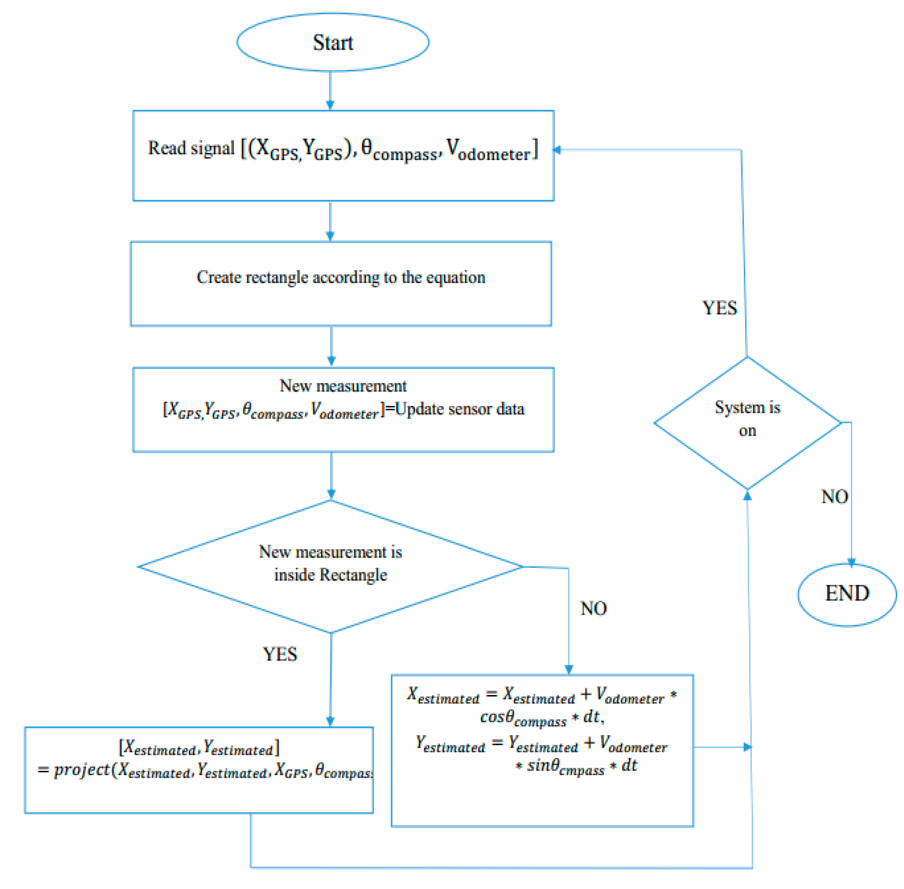
3.1. Rectangle-Aided Location-Aided Routing (RALAR)

The conventional LAR protocol utilized location information provided by GPS sensors [29]. It helps to reduce the search space by exchanging data packets through the network for the desired route. The conventional LAR protocol has not exploited the fact that nodes do not have a complete random movement in VANETs [30]. This means that the nodes in the LAR protocol are able to predict the position of the destination node by ignoring the fact that the pre-defined constraint on the destination node navigation was encountered [31]. Moreover, the KALAR protocol only uses the real mobility vehicles and model-driven traces with the Kalman Filter. It predicts the vehicle position from its previous and current position. Without Kalman Filter, this approach calculates the Euclidian distance among the destination node and the neighboring node and sends the data to the node which has the shortest distance. The KALAR protocol estimates and corrects the linearity by using the feedback system to calculate the position of the vehicle [32]. This might cause the wrong position identification of the vehicle due to higher computational time and complexity. In contrast, the proposed RALAR estimation based on the heuristic approach has been developed to reject weak GPS location data and accept good ones. The idea will be based on a moving rectangular zone according to the node’s mobility model, which will be explained below.
The proposed RALAR is the positing-based routing protocol, in which the nodes communicate with each other by utilizing the IEEE 802.11p distributed coordination function (DCF), which is the fundamental medium access control (MAC) technique, as suggested by [33,34]. In order to get location information, every vehicle (car) is provided with a GPS to determine ( X , Y ) position. This consists of a compass to determine the direction of the vehicle, and an odometer to determine the speed of the vehicle. However, using these sensors does not always guarantee exact information about the position; therefore, including a model to improve the estimation of vehicle location will improve the performance of the network. In the proposed RALAR, it is supposed that the position of the vehicle is ( X 0 , Y 0 ) , and the speed is V at time t0, as shown in Figure 1. By using a magnetic compass, the direction of a vehicle can be determined. At the time t1, the GPS determines and accepts the position if the vehicle is inside a rectangle defined in front of the vehicle (last estimated position). The backside of the rectangle passes through the vehicle’s center, and the length of the sides is equal to a distance threshold. In order to determine a value for the threshold, several parameters can be considered, such as car speed, GPS response time, the speed limit of the road, and the curvature of the road. The distance threshold to calculate the length of the rectangle can be represent as follows
T h r e s h o l d = C a r   V e l o c i t y × t i m e   p e r i o d   o f   G P S + c o n s t
Here, a const parameter has been added which defines the chance of error that occurred in the odometer to get the accurate value. Hereafter, if the measurement is accepted (inside the rectangle), the value must be corrected. It is due to the measured position that could be close enough to be accepted; however, it also refers to the value of the real path. Moreover, it is clear that if the distance between the position at t0 and the position at t1 is higher than a threshold value (outside the rectangle), the previous value has been considered as rejected, which means that the new value of car position is now updated according to the following equations
X n e w = X o l d + V X × d t
Y n e w = Y o l d + V Y × d t
Here, V refers to the velocity of the odometer, ( X , Y ) represent the GPS positions and d t refers to the compass.
The proposed RALAR protocol provides a position estimation subsystem that can be used with any other LAR or even Location-Based Service (LBS) protocol in the VANET environment. In other words, the LAR routing protocol has not been enhanced to be implemented directly in the VANET environment; however, a new layer named the position prediction layer (rectangular zone) has been developed. This is to provide more accurate information that can be used with any other routing protocol based on location information similar to the LAR protocol. In the proposed approach, the LAR protocol is utilized, because it is based on the methodology where it determines the expected and requested zone by using the position of the destination node and source node, respectively. The conventional LAR protocol utilized the received signals from the GPS that may cause error value (due to breaching the outer layer). This means if GPS gives the wrong position value of the node, the exact route for a destination is impossible to find. In this regard, the proposed heuristic RALAR protocol uses the idea of rejecting weak GPS location value and accepting good ones. It can be achieved by using a moving rectangular zone that was designed based on the node’s mobility model.
In Figure 2, the process of the proposed RALAR protocol has been drawn. This explains that the proposed RALAR gets the location information from the last estimated position and starts creating the rectangle zone. The latest obtained measurement values from the sensors (i.e., GPS, compass, odometer) were collected. The measurements were also tested to confirm the idea that they were actually located inside the prediction layer (i.e., a rectangular zone). In the case of the measurement, if the values are found to be inside the rectangle, they will be accepted and deemed to be correct, or else it will be rejected and updated for the next value. This process will always be in a continuous state until the system is stopped to finish the algorithm.

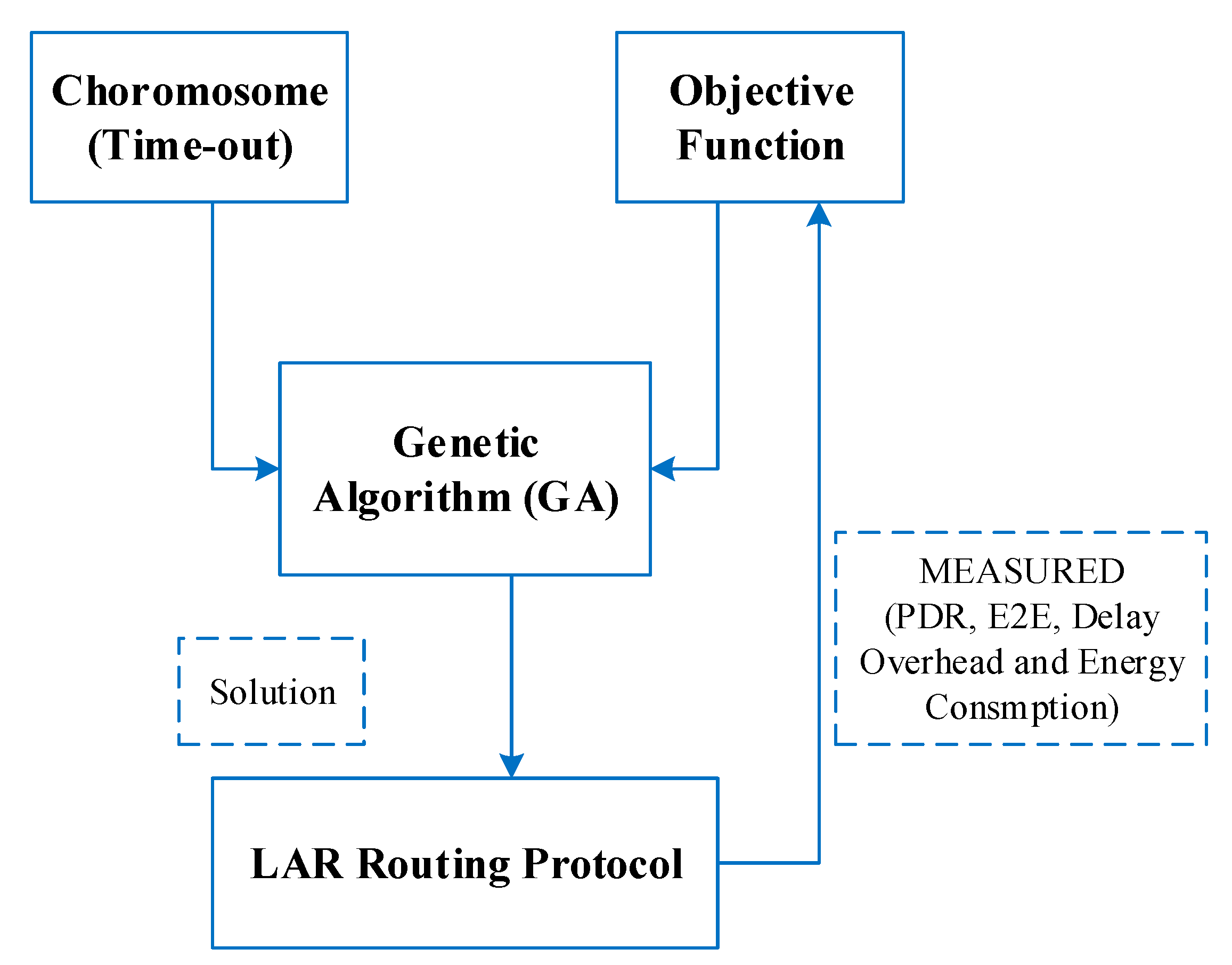
3.2. Optimization Timeout for RALAR Using Genetic Algorithm (GA)

The performance of the conventional LAR protocol in a network corresponds to the route request timeout, which is the time that the node should wait before initiating a new route request [35]. This means that if a route request does not get a response with a route reply message within the timeout, the route request packet will be canceled and reinitiate the new route discovery process [36]. This is because the nodes in a conventional LAR protocol utilize the location information of the destination node before selecting the route location, which is most likely to be expired because of the fast movement of the nodes in the VANET environment [37]. The default value timeout was usually set up to a maximum of 2 s. However, this timeout value may not satisfy all the network cases because each scenario has its own application and different network situation. Therefore, there is a definite need for a method that can determine the appropriate value of this timeout [38]. In this regard, the proposed RALAR protocol utilized the GA optimization approach to select the most suitable timeout variable. The GA was used where the chromosome is a scalar quantity representing route request timeout [39]. The GA aims to minimize the following function
F i t v a l = A v e r a g e   E 2 E   D e l a y + O v e r h e a d + ( 0.5 × A v e r a g e   E n e r g y   C o n s u m p t i o n ) ( 100 × P D R )
The basic idea of utilizing the GA is to discover the best value of the timeout value. In order to do this, random numbers of time values are generated by a new generation. Then, each of these values is tested in the network, and the corresponding performance is measured to determine the value of the objective function. Next, a new generation of values is obtained based on the elites or the best value in the previous iteration by using two operations, i.e., the crossover and the mutation. The GA works for the pre-determined number of iterations (number of generations) to find the best timeout value. Figure 3 shows the process of timeout optimization.

4. Simulation Environment

To validate the performance of the proposed RALAR algorithm, an extensive simulation experimental work was performed by using the MATLAB environment. As shown in Figure 4, the plot used for simulation was the original image containing a part of Kuala Lumpur extracted from the GPS (Google map) application. Each of the routes has a speed limit that has a varying range from 60 to 100 Km/h. The time period of reading and refreshing the GPS application was set as 1 s The experiments were conducted for three different protocols (models), each of which contained 50 nodes that were distributed randomly in the map, and simulation time was set at 1500 s. The circular coverage zone of the node was fixed at 150 m of the radius. The first experiment was conducted with the LAR without any model (conventional LAR), whereas the other two contained the proposed RALAR (rectangle) and KALAR (benchmark) model. The chromosome of the GA was a scalar quantity, which ranges from 0.5 to 5 s. The population size was been set to 40, and the experiment lasted for 40 generations. The results were evaluated in terms of PDR, average E2E delay, routing overhead, and average energy consumption of nodes. Table 1 provides a summary of the simulation parameters.

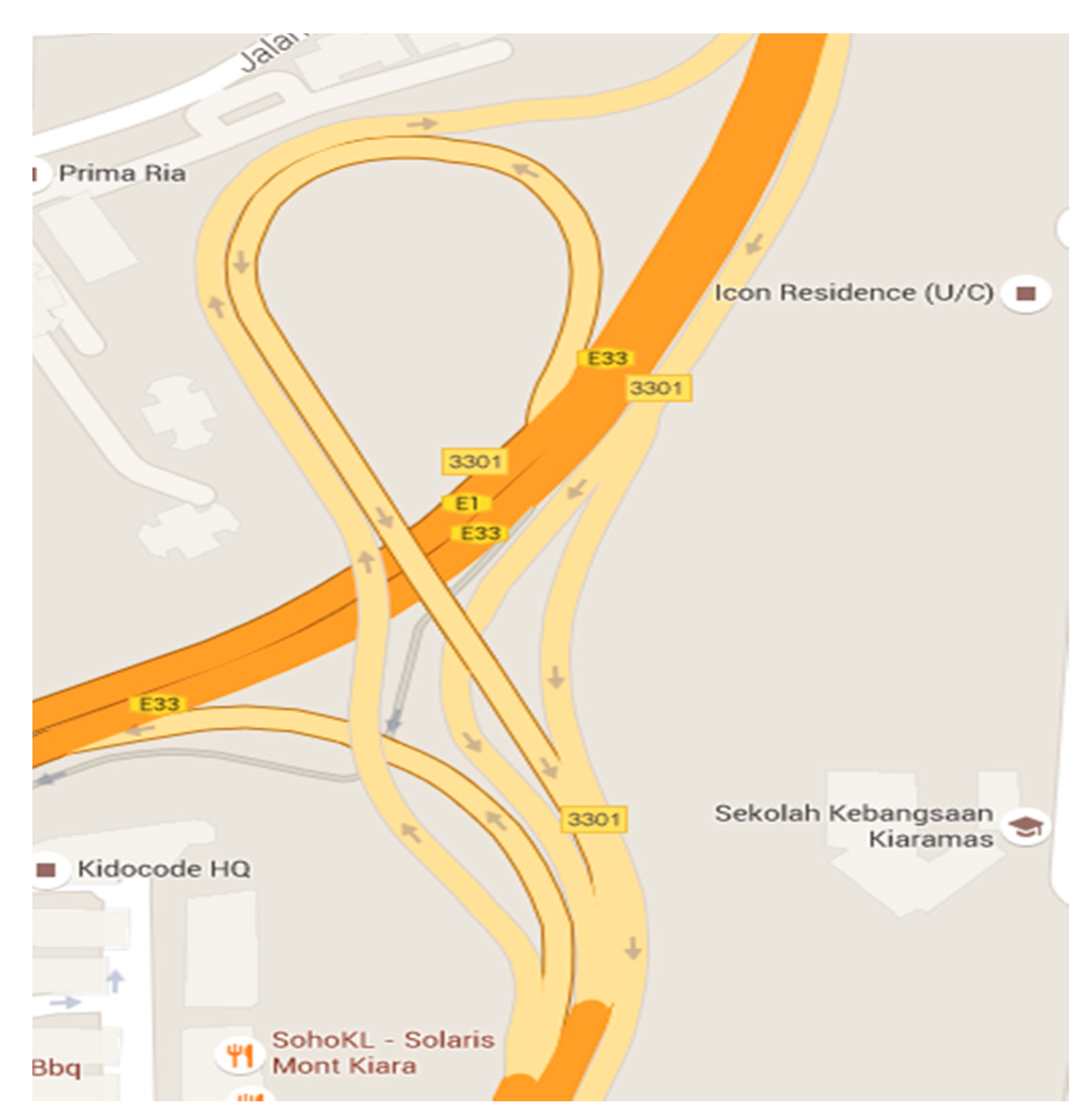
4.1. Data Generation

The generation of data packets inside the nodes was performed by using two Poisson random variables, where the first one was for the time of generation with mean equal to 6 s, and the other was for several generated packets with mean equal to four packets. The maximum value of the data packet lifetime was set at 10 s.

4.2. Node’s Mobility Model

The mobility models indicate the actual performance of vehicular traffic flow on the road as likely. One crucial feature while simulating VANET is the utilization of mobility models. In this paper, we utilized the Geographic Information System (GIS)-based mobility model to design the real environment of Kuala Lumpur City [40]. However, it does not depict some realistic scenarios of mobility, such as an expressway to avoid accidents, and the speed of a vehicle cannot go beyond the speed of the vehicle in front. The GIS-based mobility model uses the street maps extracted from Topologically Integrated Geographic Encoding and Referencing (TIGER) database including speed limit information, number of lanes, acceleration/deacceleration, car velocity, and other data [41,42]. For the propagation characteristics, we utilized the free space propagation path loss model, which can provide a close to realistic model feature of the actual environment. Table 2 shows the summary of the node’s mobility model parameters.

4.3. The Performance Metrics

Various performance metrics were utilized in this study, such as Packet Delivery Ratio (PDR), average End-to-End Delay (E2E Delay), routing overhead, and average energy consumption [43,44]. The performance metrics were used in the quantitative evaluation of the routing protocols in the network. This study adopted the following performance metric to evaluate the results for the proposed RALAR protocol:
  • Packet Delivery Ratio (PDR): This is the number of the packet received divided by the number of the packet sent;
  • Average End-to-End Delay (E2E Delay): This is the difference of time between the packet arrival and packet send packet divided by the total number packet;
  • Routing Overhead: The routing overhead metric refers to the total number of routing packets divided by the total number of delivered data packets [45];
  • Average Energy Consumption: This is the total energy consumed by each node in the network divided by its initial energy [46].

5. Results and Discussion

This section will show the results that were obtained from the simulations to evaluate the performance of the proposed RALAR algorithm. The outcomes were compared with the conventional LAR (LAR without model) and the KALAR (Benchmark) approach in terms of PDR, average E2E delay, routing overhead, and energy consumption concerning the simulation time of 1500 s. The experimental simulation was carried out in VANET to enhance the GPS location data, which can lead to improvements in the performance of the VANET environment.

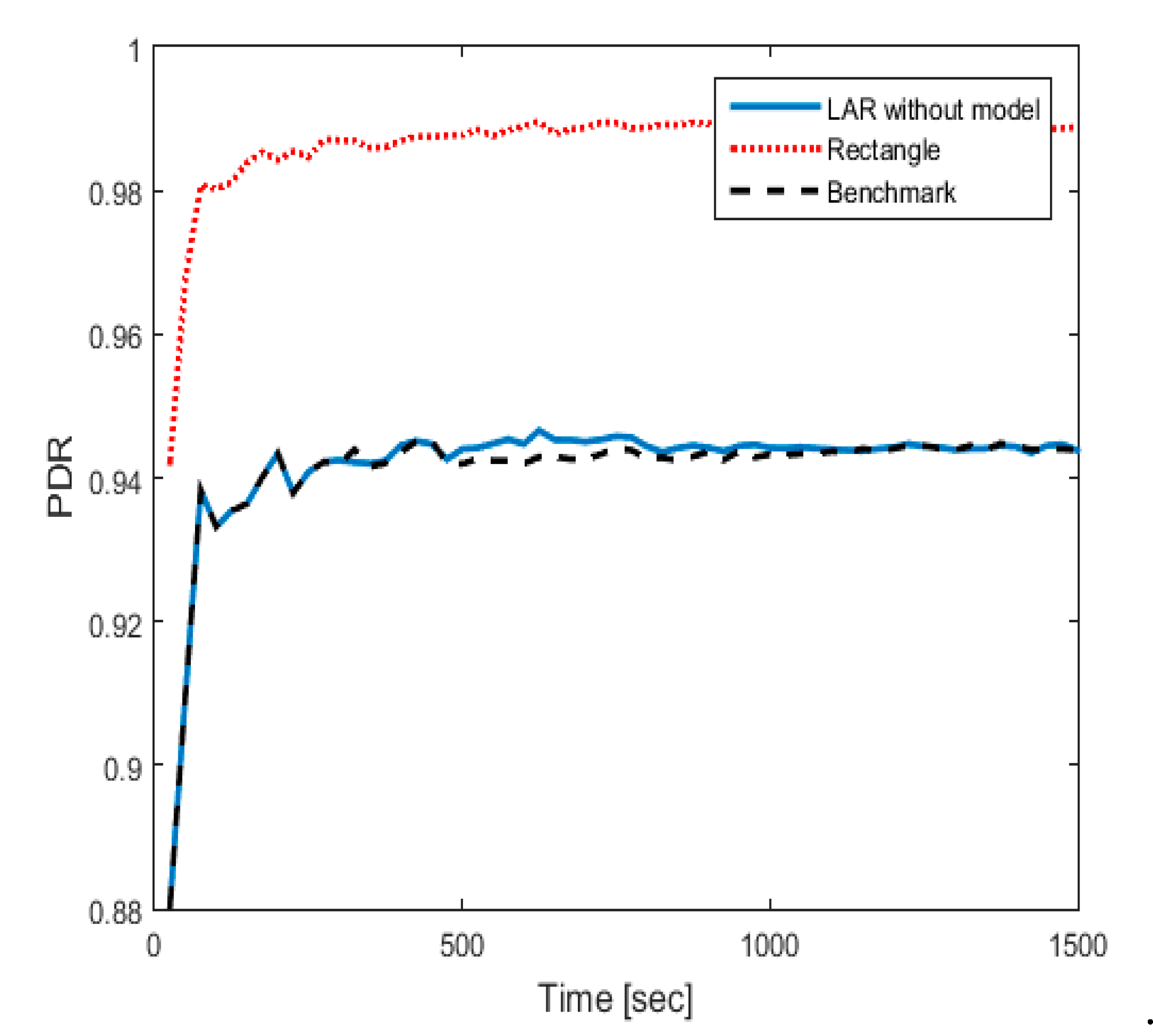
5.1. Packet Delivery Ratio (PDR)

The findings of PDR values for the proposed RALAR are shown in Figure 5. The results show that the proposed RALAR algorithm delivered a much better overall performance than the LAR protocol and KALAR approach. The proposed RALAR algorithm achieved an average PDR value equal to 0.9888, whereas the KALAR approach and the LAR protocol achieved an average PDR value of 0.9439 and 0.9438, respectively. This is due to using the concept of moving the rectangular zone to estimate the location, where this rectangular zone rejects the bad GPS location data and accepts the good GPS location data only. The results show that the KALAR approach is a bit higher than the LAR protocol.

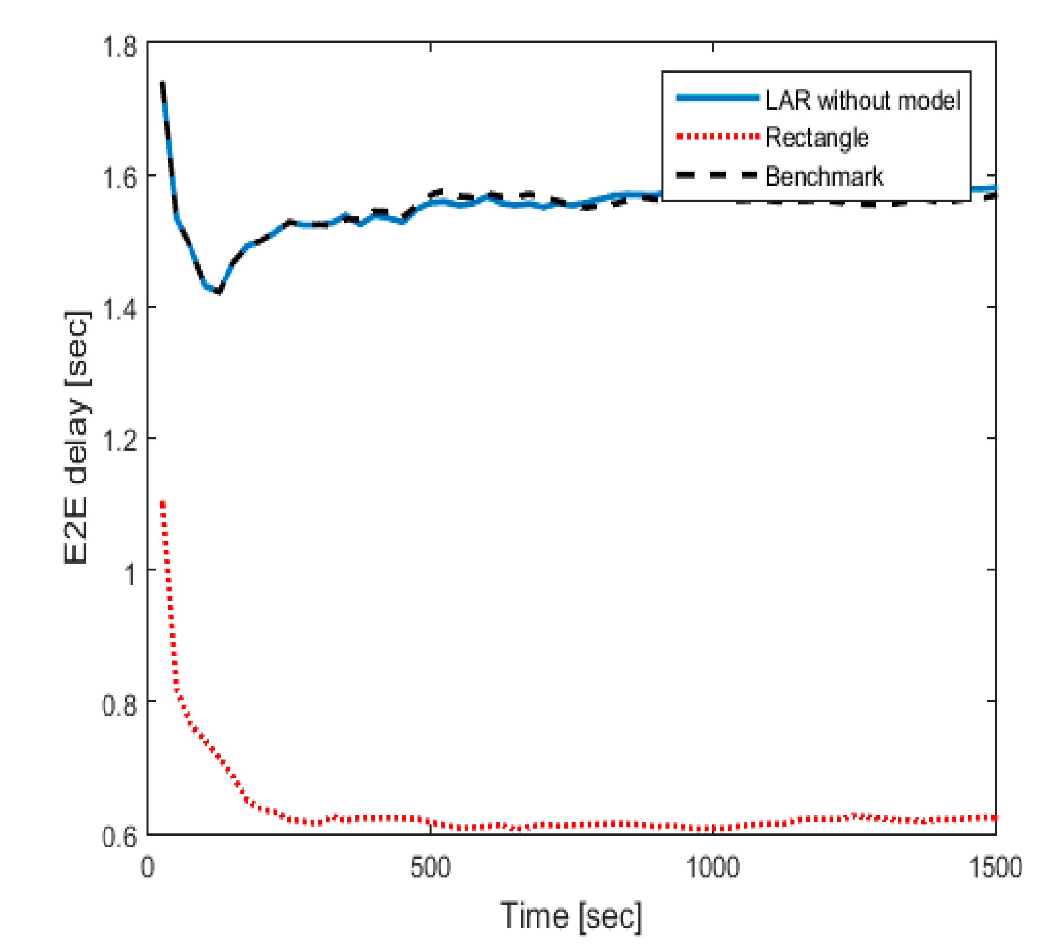
5.2. Average End-to-End Delay (E2E Delay)

For the average E2E delay, the results of the proposed RALAR, KALAR, and LAR protocol are shown in Figure 6. It can be seen that the proposed RALAR algorithm significantly outperformed the other approaches. The performance of the proposed RALAR algorithm achieved an average E2E delay value equal to 0.6237 s. Meanwhile, the performance of the KALAR and LAR protocol reached an average E2E delay value of 1.568 and 3.051 s, respectively. The results proved that the proposed RALAR algorithm performs better than the KALAR and LAR protocol. This can be achieved because the proposed RALAR algorithm is based on a rectangular zone, which utilizes the GA optimization approach for selecting the most suitable timeout variable that helps reduce the E2E delay. Besides, KALAR and LAR performance are very much correlated; however, the KLAR performance is slightly better than the LAR protocol.

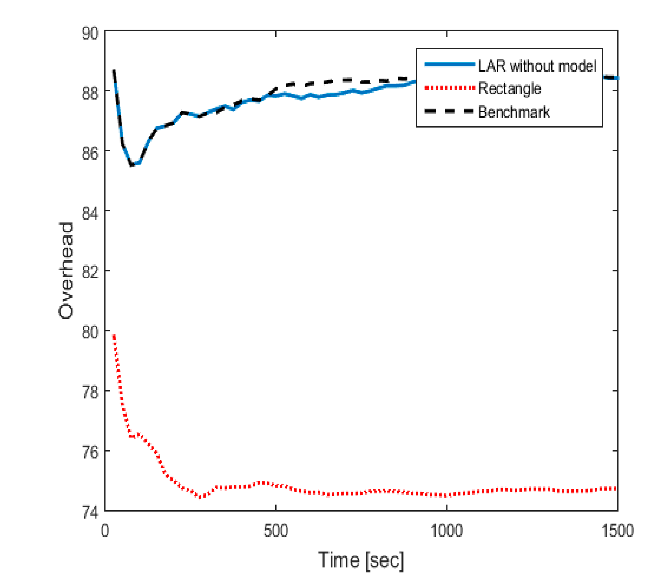
5.3. Routing Overhead

Figure 7 shows a performance comparison between the proposed RALAR, KALAR, and LAR protocol in terms of routing overhead. The results show that the routing overhead of the proposed RALAR algorithm is much lower compared to the KALAR and LAR protocol. The achieved routing overhead value for the RALAR algorithm has equal to 74.72, whereas the KALAR and LAR achieved routing overhead values equal to 88.45 and 88.43, respectively. The better performance of the proposed RALAR algorithm is due to the adoption of an estimation-based heuristic approach that was developed to reject bad GPS location data and accept good ones based on a moving rectangular zone according to the node’s mobility model. It is also noticeable that the performance of the LAR protocol is slightly lower than the KALAR approach in routing overhead.

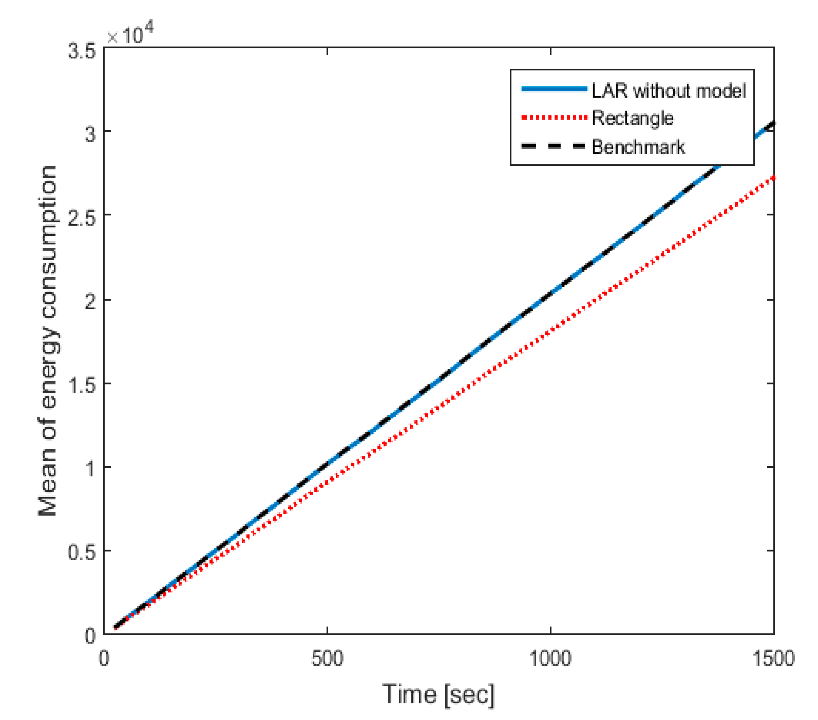
5.4. Average Energy Consumption

The performance comparison for the proposed RALAR, KALAR, and LAR protocol in terms of average energy consumption has been presented in Figure 8. The results show that the energy consumption for the proposed RALAR algorithm is much lower than the KALAR and LAR protocol. The proposed RALAR algorithm achieved an average energy consumption value equal to 2.724 × 10⁴ joule, whereas, the KALAR and LAR protocol achieved an average energy consumption value equal to 3.052 × 10⁴ and 3.050 × 10⁴ joule, respectively. The results prove that the proposed RALAR algorithm performed better because it is limited to the rectangular zone along with the utilization of the GA optimization to estimate the exact timeout. This helps to prolong the lifetime of the network by using the RALAR protocol, which is not the case for the LAR and KALAR protocols. Moreover, it is also noticed that the LAR and KALAR results are very similar; however, the LAR delivers slightly lower results as compared to the KALAR approach.

6. Conclusions

With the rapid growth in number of vehicles and the complexity of the town’s roads, previous studies have proposed many routing protocols that are used in VANETs, such as the LAR protocol. However, applying the conventional LAR protocol directly in VANET ignores two essential aspects, i.e., (1) the LAR does not exploit the fact that nodes in VANET do not have pure random movement, (2) the nodes in conventional LAR protocol use the location information of the destination node before selecting the route location, which is most likely to be expired because of the fast movement of the nodes in the VANET environment. Therefore, this paper developed an estimation based on a heuristic RALAR approach. The idea is to reject the bad GPS location data and accept good ones based on a moving rectangular zone according to the node’s mobility model. The proposed RALAR protocol was optimized using an efficient GA optimization technique to select the most suitable timeout variable. The proposed RALAR protocol was compared with the conventional KALAR and LAR protocol in terms of performance metrics such as PDR, average E2E delay, routing overhead, and average energy consumption. The results proved that the performance of the proposed heuristic RALAR protocol outperformed the KALAR and LAR protocol in terms of regular network performance measures in the VANET environment. The proposed RALAR protocol also provides a position estimation subsystem that can be used with any other location-based routing protocol or even location-based service (LBS) for the vehicle in the VANET environment.

7. Limitation and Future Work

In this work, the speed of the vehicle is limited to 60–100 km/h. Therefore, when the node speed becomes higher, the proposed RALAR approach performance might degrade, which requires more advancement in this method. Moreover, the sensing unit to find the position is based on the GPS, oedometer, and compass; however, the performance proposed RALAR protocol can be further improved by incorporating the inertial measurement unit (IMU) in the sensing system. The performance can also be affected by the noise compass that comes from the influence of the electromagnetic wave. As a future work, the location prediction model can be developed by incorporating a perception-based model such as Simultaneous Localization and Mapping (SLAM). Additionally, the dimensions of the rectangle that were used in the proposed RALAR algorithm can be enhanced to more accurately estimate nodes location. Several other novel solutions can also be explored that were recently proposed, such as an enhanced probabilistic multimeric routing protocol (EProMRP) [47] and Multimedia Multimetric Map-aware Routing Protocol (3MRP) [48]. This approach not only can improve the end-to-end packet delay and pack loss performance but also can help to identify the current node location while transmitting the data. In addition, several other suitable sets of simulation tools such as OMNeT++ [49], NS [50], Veins [51] and SUMO [52] can be utilized to design a realistic environment. Furthermore, the proposed method can be expanded to the scenario-based mobility model by experimenting with various real-life situations with the mobility patterns of mobile nodes, where it can capture environmental characteristics like the area of operation, obstacles, boundaries, intensity of traffic, type of traffic and density of the network, where a VANET may be deployed [53].

Author Contributions

Conceptualization, F.Q. and R.C.M.; Methodology, F.Q. and A.N.J.; Visualization, F.Q.; Writing—original draft preparation, R.C.M. and A.N.J.; Writing—review and editing, F.Q. and R.C.M.; Funding acquisition, R.C.M. All authors have read and agreed to the published version of the manuscript.

Funding

This paper is supported by University Kebangsaan Malaysia (UKM), UKM Grant Code: GGP-2019-023.

Acknowledgments

The authors would also like to thank the Editor and the anonymous reviewers for their valuable comments and suggestions.

Conflicts of Interest

The authors declare no conflict of interest.

References

  1. Di Maio, A.; Palattella, M.R.; Engel, T. Performance analysis of MANET routing protocols in urban VANETs. In Proceedings of the International Conference on Ad-Hoc Networks and Wireless, Luxembourg, 1–3 October 2019; pp. 432–451. [Google Scholar]
  2. Jubair, M.A.; Mostafa, S.A.; Muniyandi, R.C.; Mahdin, H.; Mustapha, A.; Hassan, M.H.; Mahmoud, M.A.; Al-Jawhar, Y.A.; Al-Khaleefa, A.S.; Mahmood, A.J. Bat optimized link state routing protocol for energy-aware mobile ad-hoc networks. Symmetry 2019, 11, 1409. [Google Scholar] [CrossRef] [Green Version]
  3. Tomar, R.; Prateek, M.; Sastry, H.G. Analysis of beaconing performance in IEEE 80211 p on vehicular ad-hoc environment. In Proceedings of the 4th IEEE Uttar Pradesh Section International Conference on Electrical, Computer and Electronics (UPCON), Mathura, India, 26–28 October 2017; pp. 692–696. [Google Scholar]
  4. Ali, I.; Hassan, A.; Li, F. Authentication and privacy schemes for vehicular ad hoc networks (VANETs): A survey. Veh. Commun. 2019, 16, 45–61. [Google Scholar] [CrossRef]
  5. Malathy, S.; Porkodi, V.; Sampathkumar, A.; Hindia, M.N.; Dimyati, K.; Tilwari, V.; Qamar, F.; Amiri, I.S. An optimal network coding based backpressure routing approach for massive IoT network. Wirel. Netw. 2020, 26, 3657–3674. [Google Scholar] [CrossRef]
  6. Kumar, S.; Verma, A.K. Position based routing protocols in VANET: A survey. Wirel. Pers. Commun. 2015, 83, 2747–2772. [Google Scholar] [CrossRef]
  7. Patel, A.; Kaushik, P. Improving QoS of VANET using adaptive CCA range and transmission range both for intelligent transportation system. Wirel. Pers. Commun. 2018, 100, 1063–1098. [Google Scholar] [CrossRef]
  8. Hussein, A.; Elhajj, I.H.; Chehab, A.; Kayssi, A. SDN VANETs in 5G: An architecture for resilient security services. In Proceedings of the Fourth International Conference on Software Defined Systems (SDS), Valencia, Spain, 8–11 May 2017; pp. 67–74. [Google Scholar]
  9. Rasheed, A.; Gillani, S.; Ajmal, S.; Qayyum, A. Vehicular ad hoc network (VANET): A survey, challenges, and applications. In Vehicular Ad-Hoc Networks for Smart Cities; Springer: Singapore, 2017; pp. 39–51. [Google Scholar]
  10. Kumar, P.; Verma, A.; Singhal, P. VANET Protocols with Challenges-A Review. In Proceedings of the 6th International Conference on Computing for Sustainable Global Development (INDIACom), New Delhi, India, 13–15 March 2019; pp. 598–602. [Google Scholar]
  11. Rath, M.; Pati, B.; Swain, J. Communiqué issues in MANET and VANET protocols with network security disquiet. In Forensic Investigations and Risk Management in Mobile and Wireless Communications; IGI Global: Hershey, PA, USA, 2020; pp. 195–220. [Google Scholar]
  12. Tilwari, V.; Hindia, M.N.; Dimyati, K.; Qamar, F.; Talip, A.; Sofian, M. Contention window and residual battery aware multipath routing schemes in mobile ad-hoc networks. Int. J. Technol. 2019, 10, 1376–1384. [Google Scholar] [CrossRef] [Green Version]
  13. Sharma, S.; Sharma, P. Comprehensive study of various routing protocols in VANET. In Proceedings of the International Conference on Intelligent Computing and Control Systems (ICCS), Madurai, India, 15–17 May 2019; pp. 1272–1275. [Google Scholar]
  14. Rana, K.K.; Tripathi, S.; Raw, R.S. opportunistic directional location aided routing protocol for vehicular ad-hoc network. Wirel. Pers. Commun. 2020, 110, 1217–1235. [Google Scholar] [CrossRef]
  15. Chekkouri, A.S.; Ezzouhairi, A.; Pierre, S. A new integrated VANET-LTE-A architecture for enhanced mobility in small cells HetNet using dynamic gateway and traffic forwarding. Comput. Netw. 2018, 140, 15–27. [Google Scholar] [CrossRef]
  16. Mustafa, Q.A.-S.; Muniyandi, R.C. Optimised tail-based routing for VANETs using multi-objective particle swarm optimisation with angle searching. Int. J. Adv. Comput. Sci. Appl. 2020, 11, 224–232. [Google Scholar] [CrossRef]
  17. Kumar, A.; Dadheech, P.; Kumari, R.; Singh, V. An enhanced energy efficient routing protocol for VANET using special cross over in genetic algorithm. J. Stat. Manag. Syst. 2019, 22, 1349–1364. [Google Scholar] [CrossRef]
  18. Gurumoorthi, E.; Ayyasamy, A. Cache agent based location aided routing protocol using direction for performance enhancement in VANET. Wirel. Pers. Commun. 2019, 109, 1195–1216. [Google Scholar] [CrossRef]
  19. Pandey, K.; Raina, S.K.; Raw, R.S.; Singh, B. Throughput and delay analysis of directional-location aided routing protocol for vehicular ad hoc networks. Int. J. Commun. Syst. 2017, 30, e3192. [Google Scholar] [CrossRef]
  20. Singh, G.D.; Tomar, R.; Sastry, H.G.; Prateek, M. A review on VANET routing protocols and wireless standards. In Smart Computing and Informatics; Springer: Singapore, 2018; pp. 329–340. [Google Scholar]
  21. Wahid, I.; Ikram, A.A.; Ahmad, M.; Ali, S.; Ali, A. State of the art routing protocols in VANETs: A review. Procedia Comput. Sci. 2018, 130, 689–694. [Google Scholar] [CrossRef]
  22. Kaushal, S.K.; Singh, V.; Nagar, J.; Raw, R.S. Performance analysis of angular location aided routing (A-LAR) in VANETs. In Proceedings of the International Conference on Communication and Computing Systems (ICCCS), Kracow, Poland, 11–14 July 2017. [Google Scholar]
  23. Jaiswal, R.K.; Jaidhar, C. Location prediction algorithm for a nonlinear vehicular movement in VANET using extended Kalman filter. Wirel. Netw. 2017, 23, 2021–2036. [Google Scholar] [CrossRef]
  24. Rohani, M.; Gingras, D.; Gruyer, D. A novel approach for improved vehicular positioning using cooperative map matching and dynamic base station DGPS concept. IEEE Trans. Intell. Transp. Syst. 2016, 17, 230–239. [Google Scholar] [CrossRef] [Green Version]
  25. Nabil, M.; Hajami, A.; Haqiq, A. Improvement of route lifetime of LAR protocol for VANET in highway scenario. In Proceedings of the 12th ACS/IEEE International Conference on Computer Systems and Applications (AICCSA), Marrakech, Morocco, 17–20 November 2015; pp. 1–8. [Google Scholar]
  26. Kumar, N.; Rodrigues, J.J.; Lloret, J.; Dua, A. Replication-aware data dissemination for vehicular ad hoc networks using location determination. Mob. Netw. Appl. 2015, 20, 251–267. [Google Scholar] [CrossRef]
  27. Rana, K.K.; Tripathi, S.; Raw, R.S. Analytical analysis of improved directional location added routing protocol for VANETS. Wirel. Pers. Commun. 2018, 98, 2403–2426. [Google Scholar] [CrossRef]
  28. Khaleghitabar, A.; Farazkish, R. A New method for routing optimization in vehicular ad hoc networks (VANETs). Signal Process. Renew. Energy 2019, 3, 37–45. [Google Scholar]
  29. ABDALI, A.; Muniyandi, R.C. Optimized Model for energy Aware Location Aided Routing Protocol in MANET. Int. J. Appl. Eng. Res. 2017, 12, 4631–4637. [Google Scholar]
  30. AL-Dhief, F.T.; Muniyandi, R.C.; Sabri, N. Performance evaluation of LAR and OLSR routing protocols in forest fire detection using mobile ad-hoc network. Indian J. Sci. Technol. 2016, 9, 1–9. [Google Scholar] [CrossRef] [Green Version]
  31. Srivastava, A.; Prakash, A.; Tripathi, R. Location based routing protocols in VANET: Issues and existing solutions. Veh. Commun. 2020, 23, 100231. [Google Scholar] [CrossRef]
  32. Gurumoorthi, E.; Ayyasamy, A. Cache agent based location aided routing using distance and direction for performance enhancement in VANET. Telecommun. Syst. 2020, 73, 419–432. [Google Scholar] [CrossRef]
  33. Song, C. Performance analysis of the IEEE 802.11 p multichannel MAC protocol in vehicular ad hoc networks. Sensors 2017, 17, 2890. [Google Scholar] [CrossRef] [Green Version]
  34. Mezher, A.M.; Cárdenas, L.L.; Barrera, J.C.; Guerra, E.C.; Meng, J.; Igartua, M.A. Improved selection of the Best forwarding candidate in 3MRP for VANETs. In Proceedings of the 2019 IEEE Symposium on Computers and Communications (ISCC), Barcelona, Spain, 29 June–3 July 2019; pp. 1–6. [Google Scholar]
  35. Nazib, R.A.; Moh, S. Routing protocols for unmanned aerial vehicle-aided vehicular ad hoc networks: A Survey. IEEE Access 2020, 8, 77535–77560. [Google Scholar] [CrossRef]
  36. Hassan, M.H.; Muniyandi, R.C. An improved hybrid technique for energy and delay routing in mobile ad-hoc networks. Int. J. Appl. Eng. Res. 2017, 12, 134–139. [Google Scholar]
  37. Brendha, R.; Prakash, V.S.J. A survey on routing protocols for vehicular Ad Hoc networks. In Proceedings of the 4th International Conference on Advanced Computing and Communication Systems (ICACCS), Coimbatore, India, 6–7 January 2017; pp. 1–7. [Google Scholar]
  38. Abbasi, H.I.; Voicu, R.C.; Copeland, J.; Chang, Y. Towards fast and reliable multi-hop routing in VANETs. IEEE Trans. Mob. Comput. 2019. [CrossRef]
  39. Zhang, G.; Wu, M.; Duan, W.; Huang, X. Genetic algorithm based QoS perception routing protocol for VANETs. Wirel. Commun. Mob. Comput. 2018, 3897857. [Google Scholar] [CrossRef] [Green Version]
  40. Cloudin, S.; Kumar, P.M. Challenges on Mobility Models Suitable to Vanet. J. Softw. 2017, 12, 91–100. [Google Scholar]
  41. Loidl, M.; Wallentin, G.; Cyganski, R.; Graser, A.; Scholz, J.; Haslauer, E. GIS and transport modeling—Strengthening the spatial perspective. Isprs Int. J. Geo-Inf. 2016, 5, 84. [Google Scholar] [CrossRef] [Green Version]
  42. O’Neil-Dunne, J.; Grove, M. TIGER Road. ND GIS Hub: Bismarck, NC, USA, 2019. [Google Scholar]
  43. Tarapiah, S.; Aziz, K.; Atalla, S. Analysis the performance of vehicles ad hoc network. Procedia Comput. Sci. 2017, 124, 682–690. [Google Scholar] [CrossRef]
  44. Sallum, E.E.A.; dos Santos, G.; Alves, M.; Santos, M.M. Performance analysis and comparison of the DSDV, AODV and OLSR routing protocols under VANETs. In Proceedings of the 16th International Conference on Intelligent Transportation Systems Telecommunications (ITST), Lisboa, Portugal, 15–17 October 2018; pp. 1–7. [Google Scholar]
  45. Abbasi, I.A.; Khan, A.S.; Ali, S. Dynamic multiple junction selection based routing protocol for VANETs in city environment. Appl. Sci. 2018, 8, 687. [Google Scholar] [CrossRef] [Green Version]
  46. Shakir, H.A.; Muniyandi, R.C.; Ali, Z.M. Energy consumption in mobile ad hoc network: Challenges and solutions. J. Theor. Appl. Inf. Technol. 2019, 97, 755–764. [Google Scholar]
  47. Cárdenas, L.L.; Mezher, A.M.; Bautista, P.A.B.; Igartua, M.A. A probability-based multimetric routing protocol for vehicular ad hoc networks in urban scenarios. IEEE Access 2019, 7, 178020–178032. [Google Scholar] [CrossRef]
  48. Lemus Cárdenas, L.; Mohamad Mezher, A.; López Márquez, N.P.; Barbecho Bautista, P.; Cárdenas-Barrera, J.; Aguilar igartua, M. 3MRP+ an improved multimetric geographical routing protocol for VANETs. In Proceedings of the 15th ACM International Symposium on Performance Evaluation of Wireless Ad Hoc, Sensor, & Ubiquitous Networks, Montreal, QC, Canada, 28 October–2 November 2018; pp. 33–39. [Google Scholar]
  49. Virdis, A.; Kirsche, M. Recent Advances in Network Simulation: The OMNeT++ Environment and Its Ecosystem. Springer: Cham, Switzerland, 2019. [Google Scholar]
  50. Al-khatib, A.A.; Hassan, R. Performance evaluation of AODV, DSDV, and DSR routing protocols in MANET using NS-2 simulator. In Proceedings of the International Conference of Reliable Information and Communication Technology, Springer, Cham, Switzerland; 2017; pp. 276–284. [Google Scholar]
  51. Sommer, C.; Eckhoff, D.; Brummer, A.; Buse, D.S.; Hagenauer, F.; Joerer, S.; Segata, M. Veins: The open source vehicular network simulation framework. In Recent Advances in Network Simulation; Springer: Cham, Switzerland, 2019; pp. 215–252. [Google Scholar]
  52. Shamim Akhter, M.; Ahsan, N.; Quaderi, S.J.S.; Al Forhad, M.A.; Sumit, S.H.; Rahman, M.R. A SUMO based simulation framework for intelligent traffic management system. J. Traffic Logist. Eng. 2020, 8, 1–5. [Google Scholar]
  53. Ram, V.R.; Premasudha, B.; Suma, R. Design and implementation of a scenario-based communication model for VANETs in EXata. In Smart Intelligent Computing and Applications; Springer: Singapore, 2018; pp. 577–587. [Google Scholar]
Figure 1. Rectangle-aided location-aided routing (RALAR) Explanation.
Applsci 10 05759 g001
Figure 2. Flowchart for RALAR Algorithm.
Applsci 10 05759 g002
Figure 3. The Timeout Optimization.
Applsci 10 05759 g003
Figure 4. Part of Kuala Lumpur Map.
Applsci 10 05759 g004
Figure 5. PDR vs. Time.
Applsci 10 05759 g005
Figure 6. Average E2E Delay vs. Time.
Applsci 10 05759 g006
Figure 7. Routing Overhead vs. Time.
Applsci 10 05759 g007
Figure 8. Average Energy Consumption vs. Time.
Applsci 10 05759 g008
Table 1. Simulation parameters.
ParameterValue
SimulatorMATLAB
Channel typeWireless
Number of nodes50
Simulation time (s)1500
Routing protocolsLAR, KALAR, RALAR
speed limits range (Km/h)60–100
Moving typeConstrained in road
Node coverage zone (m)150
GPS reading period (s)1
Table 2. Node’s mobility model parameters.
Parameters Values
Speed Limit (km/h)70–110
Car Size (m)5
Congestion distance (m)2
Pedestrian crossing time (s)10
Traffic jam distance (m)3
Traffic lights2
Number of Lanes2
Acceleration movement (m/s2)1
Safe Deacceleration (m/s2)0.5

