Monitoring the Vegetation Dynamics in the Dongting Lake Wetland from 2000 to 2019 Using the BEAST Algorithm Based on Dense Landsat Time Series


Abstract
1. Introduction
2. Study Area and Materials
2.1. Study Area
2.2. Remote Sensing Data and Preprossing
2.3. Reference Data
2.4. Auxiliary Data
3. Methods
3.1. Generation of Monthly Cloud-Free NDVI Time Series Based on the Cross-Fusion Method and FSDAF Algorithm
3.2. Bayesian Estimator of Abrupt Change, Seasonal, and Trend (BEAST)
3.2.1. Decomposition Model of BEAST
3.2.2. Bayesian Ensemble Model of BEAST
3.2.3. Parameters for BEAST
3.3. Validation and Accuracy Assessment
3.4. Spatial-Temporal Vegetation Dynamics Analysis
4. Results
4.1. Fused Monthly NDVI Time Series
4.2. Abrupt Changes, Trend, and Seasonality of Wetland Vegetation Derived by the BEAST Method
4.2.1. Spatial Validation
4.2.2. Temporal Validation
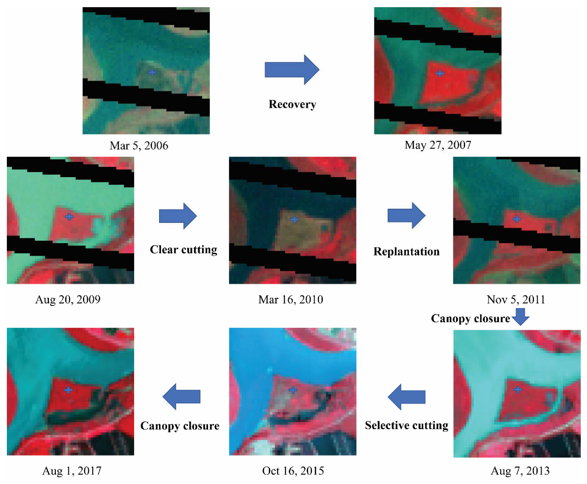
4.3. Spatial-Temporal Dynamics of Wetland Vegetation in the Dongting Lake Area
5. Discussion
6. Conclusions
Author Contributions
Funding
Acknowledgments
Conflicts of Interest
References
- Engelhardt, K.A.M.; Ritchie, M.E. Effects of macrophyte species richness on wetland ecosystem functioning and services. Nature 2001, 411, 687–689. [Google Scholar] [CrossRef] [PubMed]
- Xu, X.; Jiang, B.; Tan, Y.; Costanza, R.; Yang, G. Lake-wetland ecosystem services modeling and valuation: Progress, gaps, and future directions. Ecosyst. Serv. 2018, 33, 19–28. [Google Scholar] [CrossRef]
- Qin, L.-T.; Pang, X.-R.; Zeng, H.-H.; Liang, Y.-P.; Mo, L.-Y.; Wang, D.-Q.; Dai, J.-F. Ecological and human health risk of sulfonamides in surface water and groundwater of Huixian karst wetland in Guilin, China. Sci. Total. Environ. 2020, 708, 134552. [Google Scholar] [CrossRef]
- Ricaurte, L.F.; Olaya-Rodríguez, M.H.; Cepeda-Valencia, J.; Lara, D.; Arroyave-Suárez, J.; Finlayson, C.M.; Palomo, I. Future impacts of drivers of change on wetland ecosystem services in Colombia. Glob. Environ. Chang. 2017, 44, 158–169. [Google Scholar] [CrossRef]
- Tousignant, M.; Pellerin, S.; Brisson, J. The Relative Impact of Human Disturbances on the Vegetation of a Large Wetland Complex. Wetlands 2010, 30, 333–344. [Google Scholar] [CrossRef]
- Sun, T.; Lin, W.; Chen, G.; Guo, P.; Zeng, Y. Wetland ecosystem health assessment through integrating remote sensing and inventory data with an assessment model for the Hangzhou Bay, China. Sci. Total. Environ. 2016, 566, 627–640. [Google Scholar] [CrossRef]
- Xu, J.; Zheng, L.; Xu, L.; Wang, X. Uptake, and allocation of selected metals by dominant vegetation in Poyang Lake wetland: From rhizosphere to plant tissues. Catena 2020, 189, 104477. [Google Scholar] [CrossRef]
- Cai, Y.; Lin, H.; Zhang, M. Mapping paddy rice by the object-based random forest method using time series Sentinel-1/Sentinel-2 data. Adv. Space Res. 2019, 64, 2233–2244. [Google Scholar] [CrossRef]
- Schmidt, M.; Lucas, R.; Bunting, P.; Verbesselt, J.; Armston, J. Multi-resolution time series imagery for forest disturbance and regrowth monitoring in Queensland, Australia. Remote. Sens. Environ. 2015, 158, 156–168. [Google Scholar] [CrossRef]
- Hao, J.; Xu, G.; Luo, L.; Zhang, Z.; Yang, H.; Li, H. Quantifying the relative contribution of natural and human factors to vegetation coverage variation in coastal wetlands in China. Catena 2020, 188, 104429. [Google Scholar] [CrossRef]
- Lunetta, R.S.; Knight, J.F.; Ediriwickrema, J.; Lyon, J.G.; Worthy, L.D. Land-cover change detection using multi-temporal MODIS NDVI data. Remote. Sens. Environ. 2006, 105, 142–154. [Google Scholar] [CrossRef]
- Langner, A.; Miettinen, J.; Siegert, F. Land cover change 2002–2005 in Borneo and the role of fire derived from MODIS imagery. Glob. Chang. Boil. 2007, 13, 2329–2340. [Google Scholar] [CrossRef]
- Young, S.S.; Wang, C.Y. Land-cover change analysis of China using global-scale Pathfinder AVHRR Landcover (PAL) data, 1982?92. Int. J. Remote. Sens. 2001, 22, 1457–1477. [Google Scholar] [CrossRef]
- Wulder, M.A.; White, J.C.; Goward, S.N.; Masek, J.G.; Irons, J.R.; Herold, M.; Cohen, W.B.; Loveland, T.R.; Woodcock, C.E. Landsat continuity: Issues and opportunities for land cover monitoring. Remote. Sens. Environ. 2008, 112, 955–969. [Google Scholar] [CrossRef]
- Arévalo, P.; Olofsson, P.; Woodcock, C.E. Continuous monitoring of land change activities and post-disturbance dynamics from Landsat time series: A test methodology for REDD+ reporting. Remote. Sens. Environ. 2020, 238, 111051. [Google Scholar] [CrossRef]
- Jin, H.; Huang, C.; Lang, M.; Yeo, I.-Y.; Stehman, S.V. Monitoring of wetland inundation dynamics in the Delmarva Peninsula using Landsat time-series imagery from 1985 to 2011. Remote. Sens. Environ. 2017, 190, 26–41. [Google Scholar] [CrossRef]
- Li, W.; Gong, P. Continuous monitoring of coastline dynamics in western Florida with a 30-year time series of Landsat imagery. Remote. Sens. Environ. 2016, 179, 196–209. [Google Scholar] [CrossRef]
- Pasquarella, V.J.; Holden, C.E.; Kaufman, L.; Woodcock, C.E. From imagery to ecology: Leveraging time series of all available Landsat observations to map and monitor ecosystem state and dynamics. Remote. Sens. Ecol. Conserv. 2016, 2, 152–170. [Google Scholar] [CrossRef]
- Zhu, X.; Helmer, E.H.; Gao, F.; Liu, D.; Chen, J.; Lefsky, M.A. A flexible spatiotemporal method for fusing satellite images with different resolutions. Remote. Sens. Environ. 2016, 172, 165–177. [Google Scholar] [CrossRef]
- Gao, F.; Masek, J.; Schwaller, M.; Hall, F. On the blending of the Landsat and MODIS surface reflectance: Predicting daily Landsat surface reflectance. IEEE Trans. Geosci. Remote. Sens. 2006, 44, 2207–2218. [Google Scholar] [CrossRef]
- Zhu, X.; Chen, J.; Gao, F.; Chen, X.; Masek, J.G. An enhanced spatial and temporal adaptive reflectance fusion model for complex heterogeneous regions. Remote. Sens. Environ. 2010, 114, 2610–2623. [Google Scholar] [CrossRef]
- Zhao, Y.; Huang, B.; Song, H. A robust adaptive spatial and temporal image fusion model for complex land surface changes. Remote. Sens. Environ. 2018, 208, 42–62. [Google Scholar] [CrossRef]
- Fu, D.; Chen, B.; Wang, J.; Zhu, X.; Hilker, T. An Improved Image Fusion Approach Based on Enhanced Spatial and Temporal the Adaptive Reflectance Fusion Model. Remote. Sens. 2013, 5, 6346–6360. [Google Scholar] [CrossRef]
- Edwards, A.; Kennett, R.; Price, O.; Russell-Smith, J.; Spiers, G.; Woinarski, J.C.Z. Monitoring the impacts of fire regimes on vegetation in northern Australia: An example from Kakadu National Park. Int. J. Wildland Fire 2003, 12, 427. [Google Scholar] [CrossRef]
- Rogan, J.; Franklin, J.; A Roberts, D. A comparison of methods for monitoring multitemporal vegetation change using Thematic Mapper imagery. Remote. Sens. Environ. 2002, 80, 143–156. [Google Scholar] [CrossRef]
- Munyati, C. Wetland change detection on the Kafue Flats, Zambia, by classification of a multitemporal remote sensing image dataset. Int. J. Remote. Sens. 2000, 21, 1787–1806. [Google Scholar] [CrossRef]
- Mu, S.; Li, B.; Yao, J.; Yang, G.; Wan, R.; Xu, X. Monitoring the spatio-temporal dynamics of the wetland vegetation in Poyang Lake by Landsat and MODIS observations. Sci. Total Environ. 2020, 138096. [Google Scholar] [CrossRef]
- Lu, D.; Batistella, M.; Moran, E. Integration of Landsat TM, and SPOT HRG Images for Vegetation Change Detection in the Brazilian Amazon. Photogramm. Eng. Remote. Sens. 2008, 74, 421–430. [Google Scholar] [CrossRef]
- Eastwood, J.A.; Yates, M.G.; Thomson, A.G.; Fuller, R. The reliability of vegetation indices for monitoring saltmarsh vegetation cover. Int. J. Remote. Sens. 1997, 18, 3901–3907. [Google Scholar] [CrossRef]
- Kennedy, R.E.; Yang, Z.; Cohen, W. Detecting trends in forest disturbance and recovery using yearly Landsat time series: 1. LandTrendr—Temporal segmentation algorithms. Remote. Sens. Environ. 2010, 114, 2897–2910. [Google Scholar] [CrossRef]
- Verbesselt, J.; Hyndman, R.J.; Newnham, G.; Culvenor, D. Detecting trend and seasonal changes in satellite image time series. Remote. Sens. Environ. 2010, 114, 106–115. [Google Scholar] [CrossRef]
- Jamali, S.; Jönsson, P.; Eklundh, L.; Ardö, J.; Seaquist, J. Detecting changes in vegetation trends using time series segmentation. Remote. Sens. Environ. 2015, 156, 182–195. [Google Scholar] [CrossRef]
- Huang, C.; Goward, S.N.; Masek, J.G.; Thomas, N.; Zhu, Z.; Vogelmann, J. An automated approach for reconstructing recent forest disturbance history using dense Landsat time series stacks. Remote. Sens. Environ. 2010, 114, 183–198. [Google Scholar] [CrossRef]
- Zhu, Z.; Woodcock, C.E. Continuous change detection and classification of land cover using all available Landsat data. Remote. Sens. Environ. 2014, 144, 152–171. [Google Scholar] [CrossRef]
- Brooks, E.B.; Wynne, R.; Thomas, V.A.; Blinn, C.E.; Coulston, J.W. On-the-Fly Massively Multitemporal Change Detection Using Statistical Quality Control Charts and Landsat Data. IEEE Trans. Geosci. Remote. Sens. 2013, 52, 3316–3332. [Google Scholar] [CrossRef]
- Zhao, K.; Wulder, M.A.; Hu, T.; Bright, R.; Wu, Q.; Qin, H.; Li, Y.; Toman, E.; Mallick, B.; Zhang, X.; et al. Detecting change-point, trend, and seasonality in satellite time series data to track abrupt changes and nonlinear dynamics: A Bayesian ensemble algorithm. Remote. Sens. Environ. 2019, 232, 111181. [Google Scholar] [CrossRef]
- Samanta, A.; Ganguly, S.; Hashimoto, H.; Devadiga, S.; Vermote, E.; Knyazikhin, Y.; Nemani, R.; Myneni, R. Amazon forests did not green-up during the 2005 drought. Geophys. Res. Lett. 2010, 37, 37. [Google Scholar] [CrossRef]
- Huete, A.; Didan, K.; Shimabukuro, Y.E.; Ratana, P.; Saleska, S.; Yang, W.; Hutyra, L.R.; Nemani, R.; Myneni, R. Amazon rainforests green-up with sunlight in dry season. Geophys. Res. Lett. 2006, 33. [Google Scholar] [CrossRef]
- Healey, S.P.; Cohen, W.; Yang, Z.; Brewer, C.K.; Brooks, E.B.; Gorelick, N.; Hernandez, A.; Huang, C.; Hughes, M.J.; Kennedy, R.E.; et al. Mapping forest change using stacked generalization: An ensemble approach. Remote. Sens. Environ. 2018, 204, 717–728. [Google Scholar] [CrossRef]
- Thomas, K.L.; Benstead, J.; Davies, K.L.; Lloyd, D. Role of wetland plants in the diurnal control of CH4 and CO2 fluxes in peat. Soil Boil. Biochem. 1996, 28, 17–23. [Google Scholar] [CrossRef]
- Adam, E.; Mutanga, O.; Rugege, D. Multispectral and hyperspectral remote sensing for identification and mapping of wetland vegetation: A review. Wetl. Ecol. Manag. 2009, 18, 281–296. [Google Scholar] [CrossRef]
- Wu, L.; Li, Z.; Liu, X.; Zhu, L.; Tang, Y.; Zhang, B.; Xu, B.; Liu, M.; Meng, Y.; Liu, B.; et al. Multi-Type Forest Change Detection Using BFAST and Monthly Landsat Time Series for Monitoring Spatiotemporal Dynamics of Forests in Subtropical Wetland. Remote. Sens. 2020, 12, 341. [Google Scholar] [CrossRef]
- Neubauer, S.; Verhoeven, J.T.A. Wetland Effects on Global Climate: Mechanisms, Impacts, and Management Recommendations. In Photosynthetic Adaptation; Springer Science and Business Media LLC: Berlin/Heidelberg, Germany, 2019; pp. 39–62. [Google Scholar]
- Qi, C.; Yu, X. A Survey of Hunan Seed Plants; Hunan Science and Technology Press: Changsha, China, 2002. [Google Scholar]
- Du, Y.; Pan, K.; Yu, C.; Luo, B.; Gu, W.; Sun, H.; Min, Y.; Liu, N.; Geng, Y.; Han, W.; et al. Plant diversity decreases net global warming potential integrating multiple functions in microcosms of constructed wetlands. J. Clean. Prod. 2018, 184, 718–726. [Google Scholar] [CrossRef]
- Clauss, K.; Yan, H.; Kuenzer, C. Mapping Paddy Rice in China in 2002, 2005, 2010 and 2014 with MODIS Time Series. Remote. Sens. 2016, 8, 434. [Google Scholar] [CrossRef]
- Ren, B.; Xie, Y.; Li, Y. Understory Floristic Diversity in Poplar Plantations in the Dongting Lake Wetlands, China. Wetlands 2019, 1–12. [Google Scholar] [CrossRef]
- Zhu, L.; Liu, X.; Wu, L.; Tang, Y.; Meng, Y. Long-Term Monitoring of Cropland Change near Dongting Lake, China, Using the LandTrendr Algorithm with Landsat Imagery. Remote. Sens. 2019, 11, 1234. [Google Scholar] [CrossRef]
- Kong, D.; Zhang, Y.; Gu, X.; Wang, D. A robust method for reconstructing global MODIS EVI time series on the Google Earth Engine. ISPRS J. Photogramm. Remote. Sens. 2019, 155, 13–24. [Google Scholar] [CrossRef]
- Zhu, Z.; Wang, S.; Woodcock, C.E. Improvement, and expansion of the Fmask algorithm: Cloud, cloud shadow, and snow detection for Landsats 4–7, 8, and Sentinel 2 images. Remote. Sens. Environ. 2015, 159, 269–277. [Google Scholar] [CrossRef]
- Holben, B.N. Characteristics of maximum-value composite images from temporal AVHRR data. Int. J. Remote. Sens. 1986, 7, 1417–1434. [Google Scholar] [CrossRef]
- Cohen, W.; Yang, Z.; Kennedy, R. Detecting trends in forest disturbance and recovery using yearly Landsat time series: 2. TimeSync—Tools for calibration and validation. Remote. Sens. Environ. 2010, 114, 2911–2924. [Google Scholar] [CrossRef]
- Irvin, B.J.; Ventura, S.J.; Slater, B.K. Fuzzy and isodata classification of landform elements from digital terrain data in Pleasant Valley, Wisconsin. Geoderma 1997, 77, 137–154. [Google Scholar] [CrossRef]
- Zhao, K.; Valle, D.; Popescu, S.C.; Zhang, X.; Mallick, B. Hyperspectral remote sensing of plant biochemistry using Bayesian model averaging with variable and band selection. Remote. Sens. Environ. 2013, 132, 102–119. [Google Scholar] [CrossRef]
- Green, P.J. Reversible jump Markov chain Monte Carlo computation and Bayesian model determination. Biometrika 1995, 82, 711–732. [Google Scholar] [CrossRef]
- Chen, Y.; Cao, R.; Chen, J.; Zhu, X.; Zhou, J.; Wang, G.; Shen, M.; Chen, X.; Yang, W. A New Cross-Fusion Method to Automatically Determine the Optimal Input Image Pairs for NDVI Spatiotemporal Data Fusion. IEEE Trans. Geosci. Remote. Sens. 2020, 1. [Google Scholar] [CrossRef]
- Xie, D.; Gao, F.; Sun, L.; Anderson, M. Improving Spatial-Temporal Data Fusion by Choosing Optimal Input Image Pairs. Remote. Sens. 2018, 10, 1142. [Google Scholar] [CrossRef]
- Roy, D.P.; Ju, J.; Lewis, P.; Schaaf, C.; Gao, F.; Hansen, M.; Lindquist, E. Multi-temporal MODIS–Landsat data fusion for relative radiometric normalization, gap filling, and prediction of Landsat data. Remote. Sens. Environ. 2008, 112, 3112–3130. [Google Scholar] [CrossRef]
- Bueh, C.; Ji, L.R.; Shi, N. On the medium-range process of the rainy, snowy, and cold weather of South China in early 2008 Part I: Low-frequency waves embedded in the Asian-African subtropical jet. Clim. Environ. Res. 2008, 13, 419–433. [Google Scholar]
- Morrison, J.; Higginbottom, T.; Symeonakis, E.; Jones, M.J.; Omengo, F.; Walker, S.; Cain, B. Detecting Vegetation Change in Response to Confining Elephants in Forests Using MODIS Time-Series and BFAST. Remote. Sens. 2018, 10, 1075. [Google Scholar] [CrossRef]
- Novo-Fernández, A.; Franks, S.; Wehenkel, C.; López-Serrano, P.M.; Molinier, M.; López-Sánchez, C.A. Landsat time series analysis for temperate forest cover change detection in the Sierra Madre Occidental, Durango, Mexico. Int. J. Appl. Earth Obs. Geoinf. 2018, 73, 230–244. [Google Scholar] [CrossRef]
- Abdullah, H.; Skidmore, A.K.; Darvishzadeh, R.; Heurich, M. Timing of red-edge and shortwave infrared reflectance critical for early stress detection induced by bark beetle (Ips typographus, L.) attack. Int. J. Appl. Earth Obs. Geoinf. 2019, 82, 101900. [Google Scholar] [CrossRef]
- Zarco-Tejada, P.J.; Luque, A.H.; Hernández-Clemente, R.; Beck, P. Understanding the temporal dimension of the red-edge spectral region for forest decline detection using high-resolution hyperspectral and Sentinel-2a imagery. ISPRS J. Photogramm. Remote. Sens. 2018, 137, 134–148. [Google Scholar] [CrossRef] [PubMed]
- Mian, A.; Ginolhac, G.; Ovarlez, J.-P.; Atto, A.M.; Atto, A. New Robust Statistics for Change Detection in Time Series of Multivariate SAR Images. IEEE Trans. Signal Process. 2018, 67, 520–534. [Google Scholar] [CrossRef]


| Degradation | Recovery | Stable | |
|---|---|---|---|
| PA (%) | 85.72 | 86.83 | 88.50 |
| UA (%) | 85.32 | 86.44 | 86.89 |
| OA (%) | 87.37 | ||
| Kappa coefficient | 0.85 | ||
| Types of Change | Interval Intersection (%) | Numbers of Plots | Mean Interval Length (days) | |
|---|---|---|---|---|
| Validation | BEAST | |||
| Degradation | 84.71 | 76 | 98.9 | 107.5 |
| Recovery | 88.42 | 67 | 127.3 | 132.2 |
| Average | 86.57 | —— | 113.1 | 119.9 |
| Method and Source | Accuracy | Region | Research Period | |
|---|---|---|---|---|
| Spatial Domain | Temporal Domain | |||
| MODIS EVI + BFAST [60] | 72.0% | —— | The Aberdare National Park, Kenya | 2000–2015 |
| Landsat + VCT [61] | 97.6% | —— | Sierra Madre Occidental mountain, Durango, Mexico | 1986–2012 |
| STARFM + BFAST [9] | >83.6% | within 40 d | Homogeneous forestland and grassland | 2000–2011 |
| ESTARFM + BFAST + RF [42] | 87.8% | over 1/5 pixels within or over 2 months | Mainly in forested wetland | 2000–2018 |
| The proposed method | 86.5% | 6.8 d | Heterogeneous wetland | 2000–2019 |
© 2020 by the authors. Licensee MDPI, Basel, Switzerland. This article is an open access article distributed under the terms and conditions of the Creative Commons Attribution (CC BY) license (http://creativecommons.org/licenses/by/4.0/).
Share and Cite
Cai, Y.; Liu, S.; Lin, H. Monitoring the Vegetation Dynamics in the Dongting Lake Wetland from 2000 to 2019 Using the BEAST Algorithm Based on Dense Landsat Time Series. Appl. Sci. 2020, 10, 4209. https://doi.org/10.3390/app10124209
Cai Y, Liu S, Lin H. Monitoring the Vegetation Dynamics in the Dongting Lake Wetland from 2000 to 2019 Using the BEAST Algorithm Based on Dense Landsat Time Series. Applied Sciences. 2020; 10(12):4209. https://doi.org/10.3390/app10124209
Chicago/Turabian StyleCai, Yaotong, Shutong Liu, and Hui Lin. 2020. "Monitoring the Vegetation Dynamics in the Dongting Lake Wetland from 2000 to 2019 Using the BEAST Algorithm Based on Dense Landsat Time Series" Applied Sciences 10, no. 12: 4209. https://doi.org/10.3390/app10124209
APA StyleCai, Y., Liu, S., & Lin, H. (2020). Monitoring the Vegetation Dynamics in the Dongting Lake Wetland from 2000 to 2019 Using the BEAST Algorithm Based on Dense Landsat Time Series. Applied Sciences, 10(12), 4209. https://doi.org/10.3390/app10124209