133,000 Years of Sedimentary Record in a Contourite Drift in the Western Alboran Sea: Sediment Sources and Paleocurrent Reconstruction

 ,
, 
 , ,
, ,  ,
,
Abstract
1. Introduction
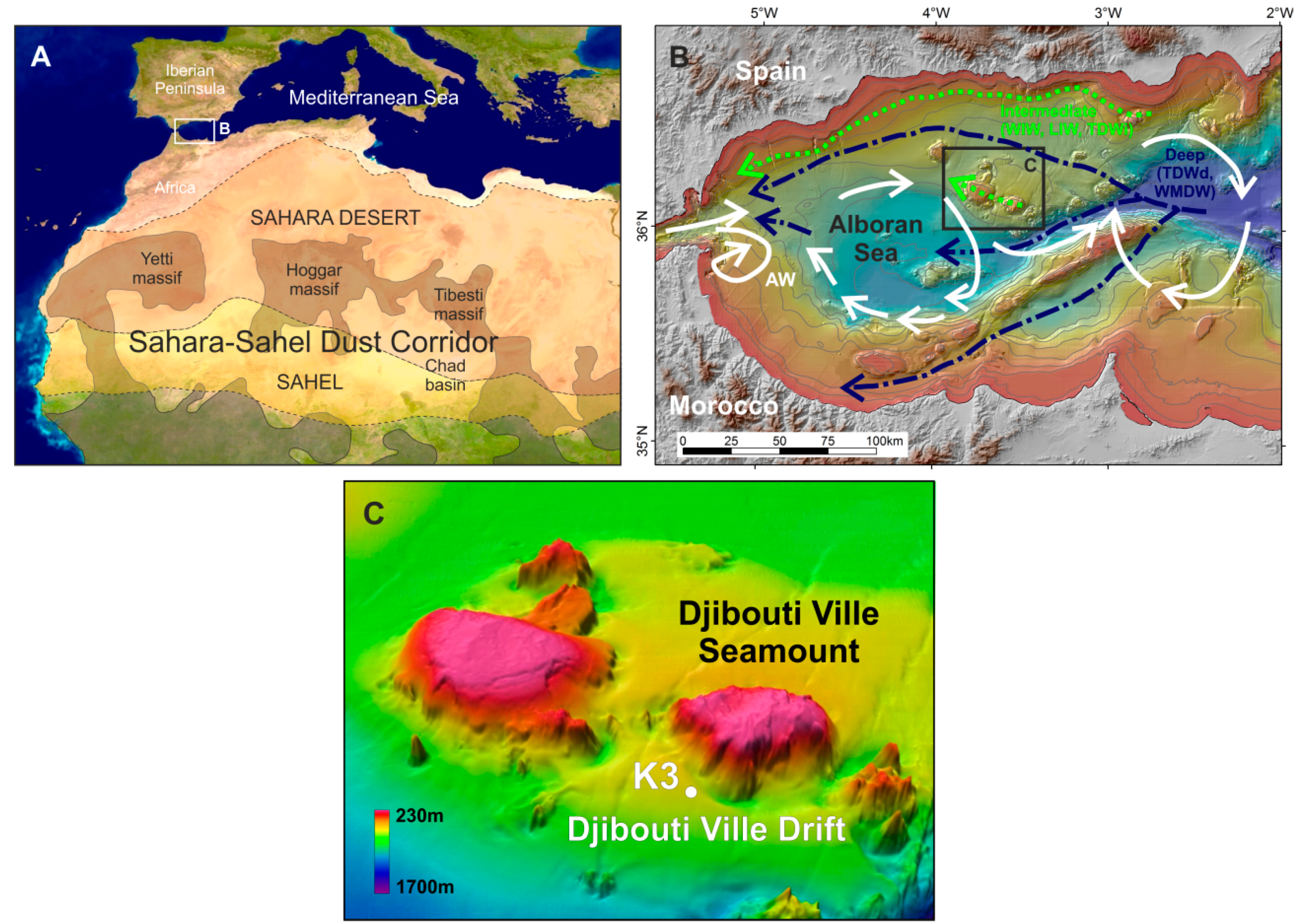
Regional Setting and Present Day Oceanography
2. Materials and Methods
2.1. Dataset
2.2. CTD Analysis
2.3. Chronostratigraphy Analysis
2.4. Grain Size Analysis
2.5. End-Member Modelling
2.6. Sediment Composition Analysis and Statistical Calculations
3. Results
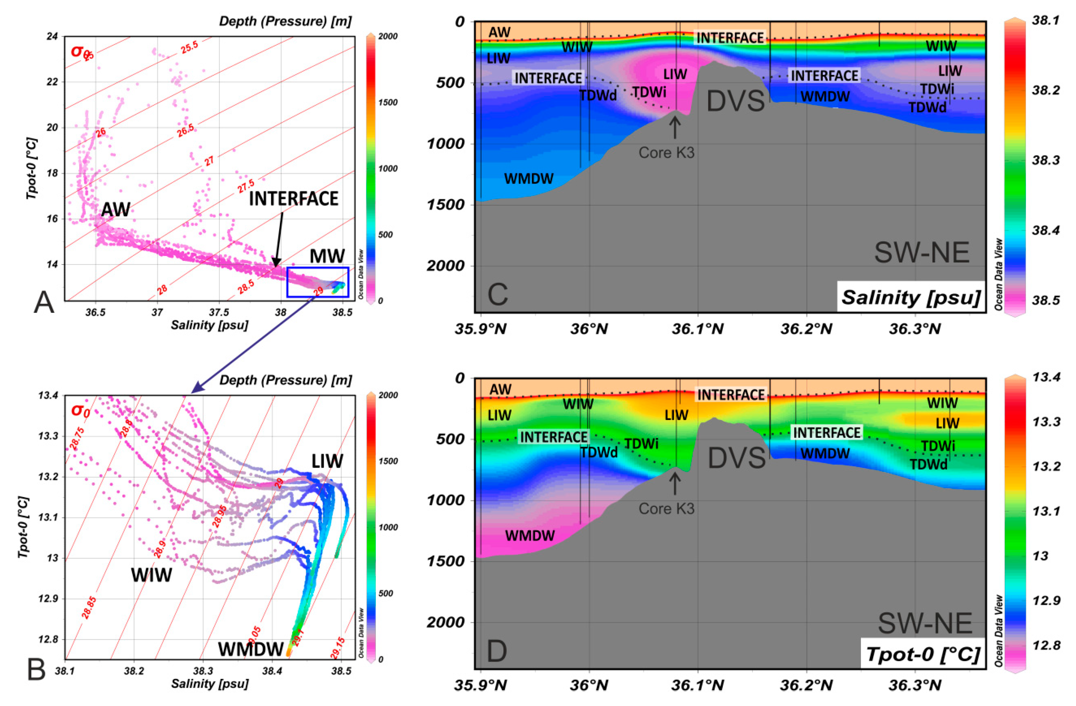
3.1. CTD Records
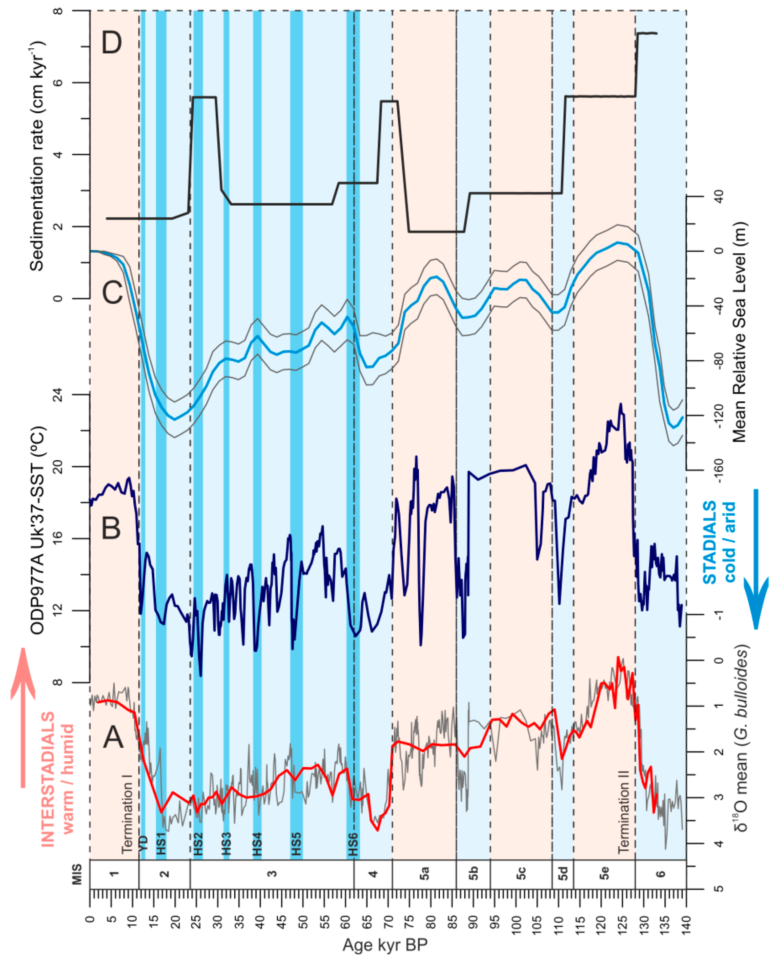
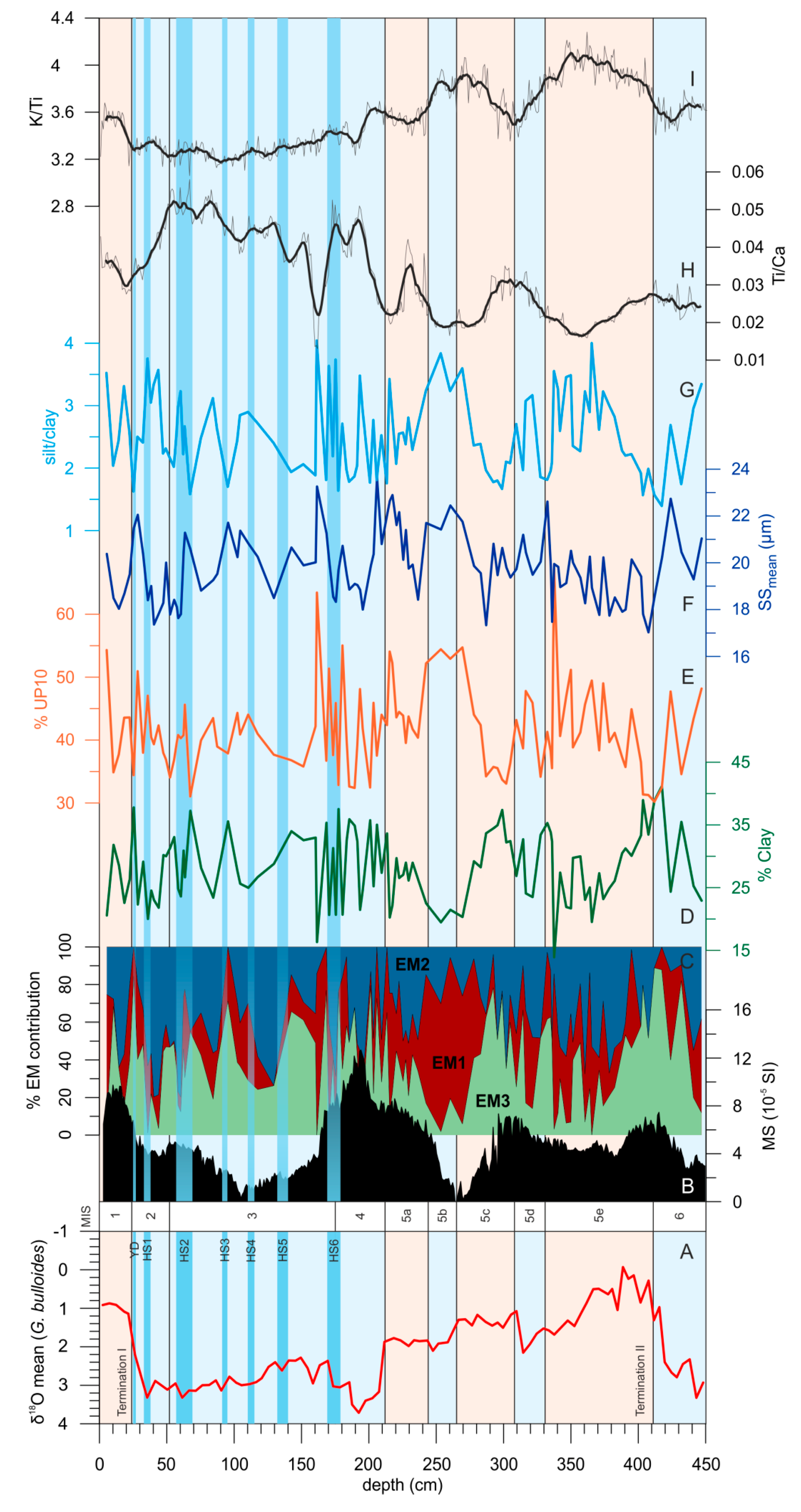
3.2. Chronostratigraphic Framework and Sedimentation Rate
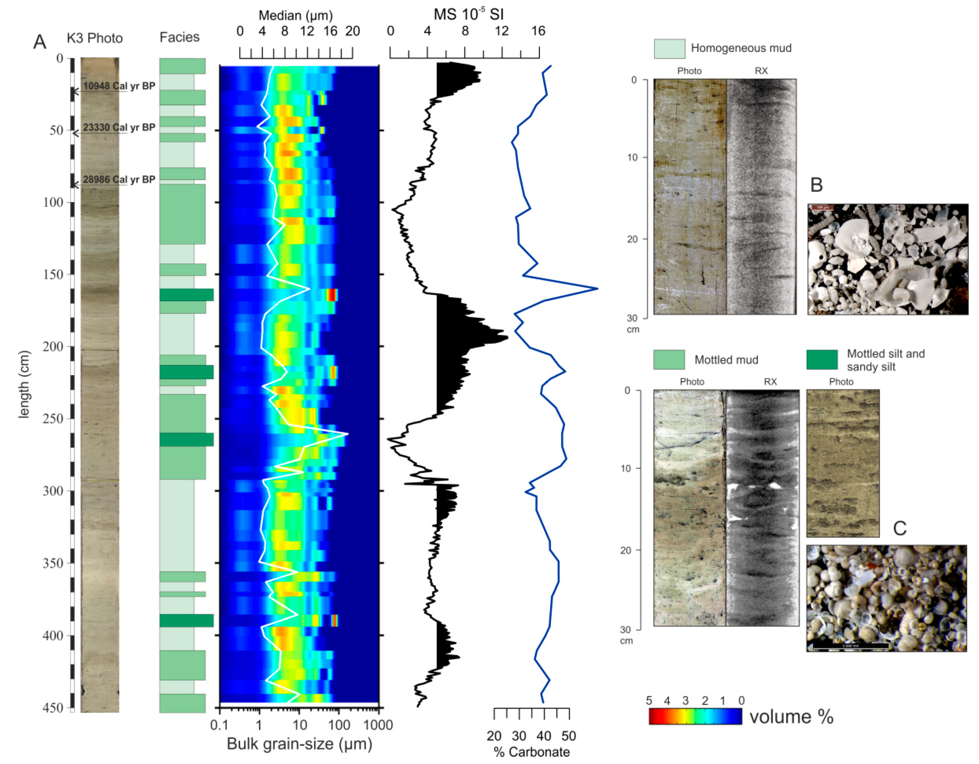
3.3. Sedimentary Facies and Sequences
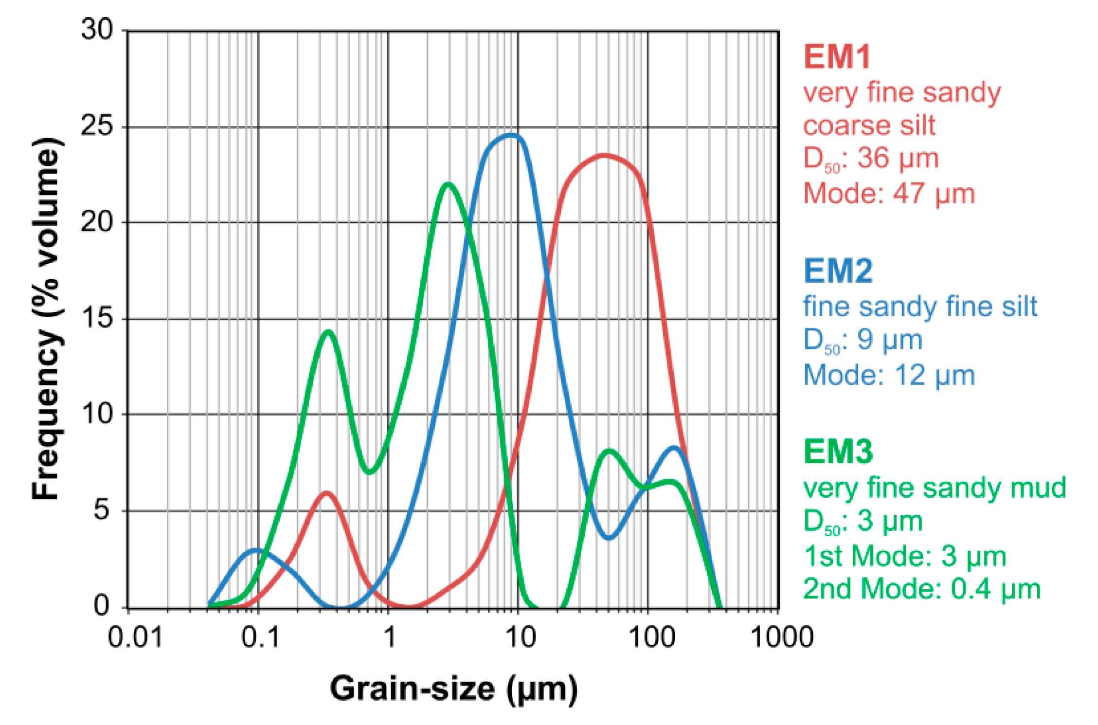
3.4. End-Member Modelling and Grain-Size Parameters
3.5. Magnetic Susceptibility and Sediment Geochemistry
4. Discussion
4.1. Drift Sediment Sources
4.2. Paleocurrent Reconstruction of the Intermediate and Deep Flows
5. Conclusions
Author Contributions
Funding
Acknowledgments
Conflicts of Interest
References
- Stow, D.A.V.; Pudsey, C.J.; Howe, J.A.; Faugères, J.-C.; Viana, A.R. Deep-Water Contourite Systems: Modern Drifts and Ancient Series, Seismic and Sedimentary Characteristics; Geological Society London: London, UK, 2002; p. 22. [Google Scholar]
- Rebesco, M.; Hernández-Molina, J.; van Rooij, D.; Wåhlin, A. Contourites and associated sediments controlled by deep-water circulation processes: state-of-the-art and future considerations. Mar. Geol. 2014, 352, 111–154. [Google Scholar] [CrossRef]
- McCave, I.N.; Manighetti, B..; Robinson, S.G. Sortable silt and fine sediment size/composition slicing: Parameters for palaeocurrent speed and palaeoceanography. Paleoceanography 1995, 10, 593–610. [Google Scholar] [CrossRef]
- Faugèers, J.-C.; Gonthier, E.; Stow, D.A.V. Contourite drift molded by deep Mediterranean outflow. Geology 1984, 12, 296. [Google Scholar] [CrossRef]
- Bianchi, G.G.; McCave, I.N. Holocene periodicity in North Atlantic climate and deep-ocean flow south of Iceland. Nature 1999, 397, 515–517. [Google Scholar] [CrossRef]
- Birgel, D.; Hass, H. Oceanic and atmospheric variations during the last deglaciation in the Fram Strait (Arctic Ocean): A coupled high-resolution organic-geochemical and sedimentological study. Quat. Sci. Rev. 2004, 23, 29–47. [Google Scholar] [CrossRef]
- Hanebuth, T.J.; Zhang, W.; Hofmann, A.L.; Löwemark, L.A.; Schwenk, T. Oceanic density fronts steering bottom-current induced sedimentation deduced from a 50 ka contourite-drift record and numerical modeling (off NW Spain). Quat. Sci. Rev. 2015, 112, 207–225. [Google Scholar] [CrossRef]
- Lofi, J.; Voelker, A.H.L.; Ducassou, E.; Hernández-Molina, F.J.; Sierro, F.J.; Bahr, A.; Galvani, A.; Lourens, L.J.; Pardo-Igúzquiza, E.; Pezard, P.; et al. Quaternary chronostratigraphic framework and sedimentary processes for the Gulf of Cadiz and Portuguese Contourite Depositional Systems derived from Natural Gamma Ray records. Mar. Geol. 2016, 377, 40–57. [Google Scholar] [CrossRef]
- Cacho, I.; Grimalt, J.O.; Sierro, F.J.; Shackleton, N.; Canals, M. Evidence for enhanced Mediterranean thermohaline circulation during rapid climatic coolings. Earth Planet. Sci. Lett. 2000, 183, 417–429. [Google Scholar] [CrossRef]
- Cacho, I.; Shackleton, N.; Elderfield, H.; Sierro, F.J.; Grimalt, J.O. Glacial rapid variability in deep-water temperature and δ18O from the Western Mediterranean Sea. Quat. Sci. Rev. 2006, 25, 3294–3311. [Google Scholar] [CrossRef]
- Ercilla, G.; Baraza, J.; Alonso, B.; Estrada, F.; Casas, D.; Farrán, M. The Ceuta Drift, Alboran Sea, southwestern Mediterranean. Geol. Soc. Lond. Memoirs 2002, 22, 155–170. [Google Scholar] [CrossRef]
- Sierro, F.J.; Hodell, D.A.; Curtis, J.H.; Flores, J.A.; Reguera, I.; Colmenero-Hidalgo, E.; Barcena, M.A.; Grimalt, J.O.; Cacho, I.; Frigola, J.; et al. Impact of iceberg melting on Mediterranean thermohaline circulation during Heinrich events. Paleoceanography 2005, 20, PA2019. [Google Scholar] [CrossRef]
- Frigola, J.; Moreno, A.; Cacho, I.; Canals, M.; Sierro, F.J.; Flores, J.A.; Grimalt, J.O.; Hodell, D.A.; Curtis, J.H. Holocene climate variability in the western Mediterranean region from a deep water sediment record. Paleoceanography 2007, 22, 1–16. [Google Scholar] [CrossRef]
- Frigola, J.; Moreno, A.; Cacho, I.; Canals, M.; Sierro, F.; Flores, J.; Grimalt, J.; Sierro, F. Evidence of abrupt changes in Western Mediterranean Deep Water circulation during the last 50kyr: A High-Resolution Marine Record from the Balearic Sea. Quat. Int. 2008, 181, 88–104. [Google Scholar] [CrossRef]
- Toucanne, S.; Jouet, G.; Ducassou, E.; Bassetti, M.-A.; Dennielou, B.; Minto’O, C.M.A.; Lahmi, M.; Touyet, N.; Charlier, K.; Lericolais, G.; et al. A 130,000-year record of Levantine Intermediate Water flow variability in the Corsica Trough, western Mediterranean Sea. Quat. Sci. Rev. 2012, 33, 55–73. [Google Scholar] [CrossRef]
- Alonso, B.; López-González, N.; Bozzano, G.; Casas, D.; Ercilla, G.; Juan, C.; Estrada, F.; Garcia, M.; Vázquez, J.T.; Cacho, I.; et al. Djibouti Ville Drift (SW Mediterranean): Sedimentation and record of bottom-current fluctuations during the Pleistocene and Holocene. In Proceedings of the 2nd Deep-Water Circulation Congress, Ghent, Belgium, 10–12 September 2014; pp. 93–94. [Google Scholar]
- Martínez-Ruiz, F.; Kastner, M.; Gallego-Torres, D.; Rodrigo-Gámiz, M.R.; Nieto-Moreno, V.; Ortega-Huertas, M. Paleoclimate and paleoceanography over the past 20,000 yr in the Mediterranean Sea Basins as indicated by sediment elemental proxies. Quat. Sci. Rev. 2015, 107, 25–46. [Google Scholar] [CrossRef]
- Ercilla, G.; Juan, C.; Hernández-Molina, F.J.; Bruno, M.; Estrada, F.; Alonso, B.; Casas, D.; Farran, M.; Llave, E.; García, M.; et al. Significance of bottom currents in deep-sea morphodynamics: An example from the Alboran Sea. Mar. Geol. 2016, 378, 157–170. [Google Scholar] [CrossRef]
- Moreno, T.; Querol, X.; Castillo, S.; Alastuey, A.; Cuevas, E.; Herrmann, L.; Mounkaila, M.; Elvira, J.; Gibbons, W. Geochemical variations in aeolian mineral particles from the Sahara–Sahel Dust Corridor. Chemosphere 2006, 65, 261–270. [Google Scholar] [CrossRef]
- Cacho, I.; Grimalt, J.O.; Pelejero, C.; Canals, M.; Sierro, F.J.; Flores, J.A.; Shackleton, N.J. Dansgaard-Oeschger and Heinrich event imprints in Alboran Sea temperatures. Paleoceanography 1999, 14, 698–705. [Google Scholar] [CrossRef]
- Cacho, I.; Grimalt, J.O.; Canals, M.; Sbaffi, L.; Shackleton, N.J.; Schönfeld, J.; Zahn, R. Variability of the western Mediterranean Sea surface temperature during the last 25,000 years and its connection with the Northern Hemisphere climatic changes. Paleoceanography 2001, 16, 40–52. [Google Scholar] [CrossRef]
- Combourieu-Nebout, N.; Turon, J.; Zahn, R.; Capotondi, L.; Londeix, L.; Pahnke, K. Enhanced aridity and atmospheric high-pressure stability over the western Mediterranean during the North Atlantic cold events of the past 50 k.y. Geology 2002, 30, 863–866. [Google Scholar] [CrossRef]
- Moreno, A.; Cacho, I.; Canals, M.; Prins, M.A.; Sánchez-Goñi, M.-F.; Grimalt, J.O.; Weltje, G.J. Saharan Dust Transport and High-Latitude Glacial Climatic Variability: The Alboran Sea Record. Quat. Res. 2002, 58, 318–328. [Google Scholar] [CrossRef]
- Moreno, A.; Cacho, I.; Canals, M.; Grimalt, J.O.; Sanchez-Vidal, A. Millennial-scale variability in the productivity signal from the Alboran Sea record, Western Mediterranean Sea. Palaeogeogr. Palaeoclim. Palaeoecol. 2004, 211, 205–219. [Google Scholar] [CrossRef]
- Bout-Roumazeilles, V.; Combourieu-Nebout, N.; Peyron, O.; Cortijo, E.; Landais, A.; Masson-Delmotte, V. Connection between South Mediterranean climate and North African atmospheric circulation during the last 50,000yrBP North Atlantic cold events. Quat. Sci. Rev. 2007, 26, 3197–3215. [Google Scholar] [CrossRef]
- Jiménez-Espejo, F.J.; Martínez-Ruiz, F.; Rogerson, M.; González Donoso, J.M.; Romero, O.E.; Linares, D.; Sakamoto, T.; Gallego-Torres, D.; Rueda Ruiz, J.L.; Ortega Huertas, M.; et al. Detrital input, productivity fluctuations, and water mass circulation in the westernmost Mediterranean Sea since the Last Glacial Maximum. Geochem. Geophy. Geosy. 2008, 9, Q11U02. [Google Scholar] [CrossRef]
- Nieto-Moreno, V.; Martínez-Ruiz, F.; Giralt, S.; Jiménez-Espejo, F.; Gallego-Torres, D.; Rodrigo-Gámiz, M.; García-Orellana, J.; Ortega-Huertas, M.; De Lange, G.J. Tracking climate variability in the western Mediterranean during the Late Holocene: a multiproxy approach. Clim. Past Discuss. 2011, 7, 635–675. [Google Scholar] [CrossRef]
- Rodrigo-Gámiz, M.; Martínez-Ruiz, F.; Jimenez-Espejo, F.J.; Gallego-Torres, D.; Nieto-Moreno, V.; Romero, O.; Ariztegui, D. Impact of climate variability in the western Mediterranean during the last 20,000 years: Oceanic and atmospheric responses. Quat. Sci. Rev. 2011, 30, 2018–2034. [Google Scholar] [CrossRef]
- De Kaenel, E.; Siesser, W.; Murat, A. Pleistocene calcareous nannofossil biostratigraphy and the western Mediterranean sapropels, Sites 974 to 977 and 979. Proc. Ocean Drill. Program 1999, 161, 159–183. [Google Scholar]
- Martrat, B.; Grimalt, J.O.; López-Martínez, C.; Cacho, I.; Sierro, F.J.; Flores, J.A.; Zahn, R.; Canals, M.; Curtis, J.H.; Hodell, D.A. Abrupt Temperature Changes in the Western Mediterranean over the Past 250,000 Years. Sciences 2004, 306, 1762–1765. [Google Scholar] [CrossRef]
- Matthewson, A.P.; Shimmield, G.B.; Kroon, D.; Fallick, A. A 300 kyr high-resolution aridity record of the North African continent. Paleoceanograhy 1995, 10, 677–692. [Google Scholar] [CrossRef]
- Moreno, A.; Cacho, I.; Canals, M.; Grimalt, J.O.; Sánchez-Goñi, M.F.; Shackleton, N.J.; Sierro, F.J. Links between marine and atmospheric processes oscillating at millennial time-scale. A multy-proxy study of the last 50,000 yr from the Alboran Sea (Western Mediterranean Sea). Quat. Sci. Rev. 2005, 24, 1623–1636. [Google Scholar] [CrossRef]
- Rodriguez-Navarro, C.; Di Lorenzo, F.; Elert, K. Mineralogy and physicochemical features of Saharan dust wet deposited in the Iberian Peninsula during an extreme red rain event. Atmos. Chem. Phys. 2018, 18, 10089–10122. [Google Scholar] [CrossRef]
- Comas, M.C.; García-Dueñas, V.; Jurado, M.J. Neogene tectonic evolution of the Alboran basin from MCS data. Geo-Mar. Lett. 1992, 12, 157–164. [Google Scholar] [CrossRef]
- Maldonado, A.; Campillo, A.C.; Mauffret, A.; Alonso, B.; Woodside, J.; Campos, J. Alboran Sea late cenozoic tectonic and stratigraphic evolution. Geo-Marine Lett. 1992, 12, 179–186. [Google Scholar] [CrossRef]
- Vázquez, J.T.; Vegas, R.; Medialdea, T. Estructuras recientes de deformación en el margen continental del mar de Alborán (Sector Benalmádena-Adra). Geotemas 2008, 10, 595–598. [Google Scholar]
- Palomino, D.; Vázquez, J.-T.; Ercilla, G.; Alonso, B.; López-González, N.; Díaz-Del-Río, V. Interaction between seabed morphology and water masses around the seamounts on the Motril Marginal Plateau (Alboran Sea, Western Mediterranean). Geo-Marine Lett. 2011, 31, 465–479. [Google Scholar] [CrossRef]
- Juan, C.; Ercilla, G.; Estrada, F.; Casas, D.; Alonso, B.; García, M.; Farran, M.; Palomino, D.; Vázquez, J.T.; Llave, E.; et al. Contourite sedimentation in the Alboran Sea: Plio-Quaternary evolution. Geotemas 2012, 13, 1817–1820. [Google Scholar]
- Vázquez, J.T. El margen continental del Mar de Alborán. In Memoria del Mapa Geomorfológico de España y del Margen Continental a E 1:1.000.000; Martín Serrano, A., Ed.; IGME: Madrid, Spain, 2005; pp. 189–198. [Google Scholar]
- Parrilla, G.; Kinder, T.H.; Preller, R.H. Deep and intermediate mediterranean water in the western Alboran Sea. Deep. Sea Res. Part A. Oceanogr. Res. Pap. 1986, 33, 55–88. [Google Scholar] [CrossRef]
- Millot, C. Circulation in the Western Mediterranean Sea. J. Mar. Syst. 1999, 20, 423–442. [Google Scholar] [CrossRef]
- Gascard, J.; Richez, C. Water masses and circulation in the Western Alboran sea and in the Straits of Gibraltar. Prog. Oceanogr. 1985, 15, 157–216. [Google Scholar] [CrossRef]
- Fabres, J.; Calafat, A.; Sanchez-Vidal, A.; Canals, M.; Heussner, S. Composition and spatio-temporal variability of particle fluxes in the Western Alboran Gyre, Mediterranean Sea. J. Mar. Syst. 2002, 33, 431–456. [Google Scholar] [CrossRef]
- Millot, C. Another description of the Mediterranean Sea outflow. Prog. Oceanogr. 2009, 82, 101–124. [Google Scholar] [CrossRef]
- Millot, C. Heterogeneities of in- and out-flows in the Mediterranean Sea. Prog. Oceanogr. 2014, 120, 254–278. [Google Scholar] [CrossRef]
- Scheuvens, D.; Schütz, L.; Kandler, K.; Ebert, M.; Weinbruch, S. Bulk composition of northern African dust and its source sediments—A compilation. Earth-Science Rev. 2013, 116, 170–194. [Google Scholar] [CrossRef]
- Stuiver, M.; Reimer, P.J. Extended 14C Data Base and Revised CALIB 3.0 14C Age Calibration Program. Radiocarbon 1993, 35, 215–230. [Google Scholar] [CrossRef]
- Reimer, P.J.; Bard, E.; Bayliss, A.; Beck, J.W.; Blackwell, P.G.; Bronk Ramsey, C.; Buck, C.E.; Cheng, H.; Edwards, R.L.; Friedrich, M.; et al. IntCal13 and Marine13 radiocarbon age calibration curves 0–50,000 years cal BP. Radiocarbon 2013, 55, 1869–1887. [Google Scholar] [CrossRef]
- McCave, I.N.; Bryant, R.J.; Cook, H.F.; Coughanowr, C.A. Evaluation of a laser-diffraction-size analyzer for use with natural sediments. J. Sediment. Res. 1986, 56, 561–564. [Google Scholar] [CrossRef]
- Folk, R.L.; Ward, W.C. Brazos River bar: a study in the significance of grain size parameters. J. Sediment. Res. 1957, 27, 3–26. [Google Scholar] [CrossRef]
- Blott, S.J.; Pye, K. GRADISTAT: A grain size distribution and statistics package for the analysis of unconsolidated sediments. Earth Surf. Process. Landforms 2001, 26, 1237–1248. [Google Scholar] [CrossRef]
- Hall, I.R.; McCave, I.N. Palaeocurrent reconstruction, sediment and thorium focussing on the Iberian margin over the last 140 ka. Earth Planet. Sci. Lett. 2000, 178, 151–164. [Google Scholar] [CrossRef]
- Cisneros, M.; Cacho, I.; Frigola, J.; Sanchez-Vidal, A.; Calafat, A.; Pedrosa-Pàmies, R.; Rumín-Caparrós, A.; Canals, M. Deep-water formation variability in the north-western Mediterranean Sea during the last 2500 yr: A proxy validation with present-day data. Glob. Planet. Chang. 2019, 177, 56–68. [Google Scholar] [CrossRef]
- Dietze, E.; Hartmann, K.; Diekmann, B.; IJmker, J.; Lehmkuhl, F.; Opitz, S.; Stauch, G.; Wünnemann, B.; Borchers, A. An end-member algorithm for deciphering modern detrital processes from lake sediments of Lake Donggi Cona, NE Tibetan Plateau, China. Sediment. Geol. 2012, 243, 169–180. [Google Scholar] [CrossRef]
- Weltje, G.J. End-member modeling of compositional data: Numerical-statistical algorithms for solving the explicit mixing problem. Math. Geol. 1997, 29, 503–549. [Google Scholar] [CrossRef]
- Weltje, G.J.; Tjallingii, R. Calibration of XRF core scanners for quantitative geochemical logging of sediment cores: Theory and application. Earth Planet. Sci. Lett. 2008, 274, 423–438. [Google Scholar] [CrossRef]
- Sánchez-Goñi, M.F.; Harrison, S.P. Millennial-scale climate variability and vegetation changes during the Last Glacial: Concepts and terminology. Quat. Sci. Rev. 2010, 29, 2823–2827. [Google Scholar] [CrossRef]
- Waelbroeck, C.; Labeyrie, L.; Michel, E.; Duplessy, J.; McManus, J.; Lambeck, K.; Balbon, E.; Labracherie, M. Sea-level and deep water temperature changes derived from benthic foraminifera isotopic records. Quat. Sci. Rev. 2002, 21, 295–305. [Google Scholar] [CrossRef]
- Rodrigo-Gámiz, M.; Martínez-Ruiz, F.; Rodríguez-Tovar, F.J.; Jiménez-Espejo, F.J.; Pardo-Igúzquiza, E. Millennial- to centennial-scale climate periodicities and forcing mechanisms in the westernmost Mediterranean for the past 20,000 yr. Quat. Res. 2014, 81, 78–93. [Google Scholar] [CrossRef]
- Ausín, B.; Flores, J.-A.; Sierro, F.-J.; Barcena, M.A.; Hernández-Almeida, I.; Frances, G.; Gutiérrez-Arnillas, E.; Martrat, B.; Grimalt, J.; Cacho, I.; et al. Coccolithophore productivity and surface water dynamics in the Alboran Sea during the last 25kyr. Palaeogeogr. Palaeoclim. Palaeoecol. 2015, 418, 126–140. [Google Scholar] [CrossRef]
- Weltje, G.J.; Prins, M.A. Genetically meaningful decomposition of grain-size distributions. Sediment. Geol. 2007, 202, 409–424. [Google Scholar] [CrossRef]
- Hodell, D.; Crowhurst, S.; Skinner, L.; Tzedakis, P.C.; Margari, V.; Channell, J.E.T.; Kamenov, G.; Maclachlan, S.; Rothwell, G. Response of Iberian Margin sediments to orbital and suborbital forcing over the past 420 ka. Paleoceanograhy 2013, 28, 185–199. [Google Scholar] [CrossRef]
- Hodell, D.A.; Evans, H.F.; Channell, J.E.; Curtis, J.H. Phase relationships of North Atlantic ice-rafted debris and surface-deep climate proxies during the last glacial period. Quat. Sci. Rev. 2010, 29, 3875–3886. [Google Scholar] [CrossRef]
- Evans, R.D.; Jefferson, I.F.; Kumar, R.; O’Hara-Dhand, K.; Smalley, I.J. The nature and early history of airbone dust from North Africa; in particular the Lake Chad basin. J. Afr. Earth Sci. 2004, 39, 81–87. [Google Scholar] [CrossRef]
- Livingstone, I.; Warren, A. Aeolian Geomorphology: An Introduction; Longman Pub Group: Harlow, UK, 1996; p. 211. [Google Scholar]
- Rothwell, R.G.; Croudace, I.W. Twenty Years of XRF Core Scanning Marine Sediments: What Do Geochemical Proxies Tell Us. In Micro-XRF Studies of Sediment Cores: Applications of A Non-Destructive Tool for the Environmental Sciences, 1st ed.; Croudace, I.W., Rothwell, R.G., Eds.; Springer: Dordrecht, The Netherlands, 2015; pp. 25–102. [Google Scholar]
- Calvert, S.E.; Pedersen, T.F. Elemental Proxies for Palaeoclimatic and Palaeoceanographic Variability in Marine Sediments: Interpretation and Application. In Proxies in Late Cenozoic Paleoceanography, 1st ed.; Hillaire-Marcel, C., De Vernal, A., Eds.; Elsevier: Amsterdam, The Netherlands, 2007; Volume 1, pp. 567–644. [Google Scholar]
- Hanebuth, T.J.; Lantzsch, H. A Late Quaternary sedimentary shelf system under hyperarid conditions: Unravelling climatic, oceanographic and sea-level controls (Golfe d’Arguin, Mauritania, NW Africa). Mar. Geol. 2008, 256, 77–89. [Google Scholar] [CrossRef]
- Giermann, G.; Pfannenstiel, M.; Wimmenauer, W. Relations entre morphologie, tectonique et volcanisme en mer d’Alboran (Mediterranée Occidentale). Compt. Rend. Somm. Soc. Fr. 1968, 4, 116–118. [Google Scholar]
- Kenyon, N.H.; Ivanov, M.K.; Akhmetzhanov, A.M.; Akhmanov, G.G. Multidisciplinary Study of Geological Processes on the North East Atlantic and Western Mediterranean Margins IOC Technical Series No. 56, UNESCO. 2000. Available online: https://folk.uio.no/adrianom/TTR%20WWW/TTR/cruises/ttr9.html (accessed on 3 June 2019).
- Hoernle, K.; Bogaard, P.V.D.; Duggen, S.; Mocek, B.; Garbe-Schönberg, D. Evidence for Miocene subduction beneath the Alboran Sea: 40Ar/39 Ar dating and geochemistry of volcanic rocks from Holes 977A and 978A. Proc. Ocean Drill. Program 1999, 161, 357–373. [Google Scholar]
- Henrich, R.; Cherubini, Y.; Meggers, H. Climate and sea level induced turbidite activity in a canyon system offshore the hyperarid Western Sahara (Mauritania): The Timiris Canyon. Mar. Geol. 2010, 275, 178–198. [Google Scholar] [CrossRef]
- Caquineau, S.; Gaudichet, A.; Gomes, L.; Magonthier, M.-C.; Chatenet, B. Saharan dust: Clay ratio as a relevant tracer to assess the origin of soil-derived aerosols. Geophys. Res. Lett. 1998, 25, 983–986. [Google Scholar] [CrossRef]
- Hernández-Molina, F.J.; Larter, R.D.; Rebesco, M.; Maldonado, A. Miocene reversal of bottom water flow along the Pacific Margin of the Antarctic Peninsula: Stratigraphic evidence from a contourite sedimentary tail. Mar. Geol. 2006, 228, 93–116. [Google Scholar] [CrossRef]
- Rodrigo, F.S.; Pozo-Vazquez, D.; Esteban-Parra, M.J.; Castro-Diez, Y. A reconstruction of the winter North Atlantic Oscillation index back to A.D. 1501 using documentary data in southern Spain. J. Geophys. Res. Space Phys. 2001, 106, 14805–14818. [Google Scholar] [CrossRef]
- Sánchez-Goñi, M.F.; Cacho, I.; Turon, J.L.; Guiot, J.; Sierro, F.J.; Peypouquet, J.P.; Grimalt, J.O.; Schackleton, N.J. Synchroneity between marine and terrestrial responses to millennial scale climatic variability during the last glacial period in the Mediterranean region. Clim. Dyn. 2002, 19, 95–105. [Google Scholar]
- Ercilla, G.; Juan, C.; Periáñez, R.; Alonso, B.; Abril, J.M.; Estrada, F.; Casas, D.; Vázquez, J.T.; D’Acremont, E.; Gorini, C.; et al. Influence of alongslope processes on modern turbidite systems and canyons in the Alboran Sea (southwestern Mediterranean). Deep. Sea Res. Part I: Oceanogr. Res. Pap. 2019, 144, 1–16. [Google Scholar] [CrossRef]
- Rossignol-Strick, M. Mediterranean Quaternary sapropels, an immediate response of the African monsoon to variation of insolation. Palaeogeogr. Palaeoclim. Palaeoecol. 1985, 49, 237–263. [Google Scholar] [CrossRef]
- Stow, D.A.V.; Faugères, J.C. Contourite facies and the facies model. In Contourites; Rebesco, M., Camerlenghi, A., Eds.; Elsevier: Amsterdam, The Netherlands, 2008; pp. 223–256. [Google Scholar]
- Nolet, G.J.; Corliss, B.H. Benthic foraminiferal evidence for reduced deep-water circulation during sapropel deposition in the eastern Mediterranean. Mar. Geol. 1990, 94, 109–130. [Google Scholar] [CrossRef]
- Myers, P.G. Flux-forced simulations of the paleocirculation of the Mediterranean. Paleoceanography 2002, 17, 9-1. [Google Scholar] [CrossRef]
- Rossignol-Strick, M. African monsoons, an immediate climate response to orbital insolation. Nature 1983, 304, 46–49. [Google Scholar] [CrossRef]
- Roether, W.; Klein, B.; Beitzel, V.; Manca, B.B. Property distributions and transient-tracer ages in Levantine Intermediate Water in the Eastern Mediterranean. J. Mar. Syst. 1998, 18, 71–87. [Google Scholar] [CrossRef]
- Bartoli, G.; Sarnthein, M.; Weinelt, M.; Erlenkeuser, H.; Garbe-Schönberg, D.; Lea, D. Final closure of Panama and the onset of northern hemisphere glaciation. Earth Planet. Sci. Lett. 2005, 237, 33–44. [Google Scholar] [CrossRef]


| Sagas Core | Latitude (N) | Longitude (W) | Water Depth (m) | Core Depth (cm) | AMS 14-C Age (yr BP) | 1σ Calibrated Age (Cal yr BP) | Median Probability Age (Cal yr BP) | Lab Code |
|---|---|---|---|---|---|---|---|---|
| K3 | 36°04.94′ | 3°35.59′ | 712 | 22–23 | 9950 ± 60 | 10,842–11,072 | 10,948 | Poz-53720 |
| 49–50 | 19,760 ± 110 | 23,148–23,506 | 23,330 | Poz-55671 | ||||
| 87–88 | 25,320 ± 220 | 28,729–29,228 | 28,986 | Poz-53721 |
© 2019 by the authors. Licensee MDPI, Basel, Switzerland. This article is an open access article distributed under the terms and conditions of the Creative Commons Attribution (CC BY) license (http://creativecommons.org/licenses/by/4.0/).
Share and Cite
López-González, N.; Alonso, B.; Juan, C.; Ercilla, G.; Bozzano, G.; Cacho, I.; Casas, D.; Palomino, D.; Vázquez, J.-T.; Estrada, F.; et al. 133,000 Years of Sedimentary Record in a Contourite Drift in the Western Alboran Sea: Sediment Sources and Paleocurrent Reconstruction. Geosciences 2019, 9, 345. https://doi.org/10.3390/geosciences9080345
López-González N, Alonso B, Juan C, Ercilla G, Bozzano G, Cacho I, Casas D, Palomino D, Vázquez J-T, Estrada F, et al. 133,000 Years of Sedimentary Record in a Contourite Drift in the Western Alboran Sea: Sediment Sources and Paleocurrent Reconstruction. Geosciences. 2019; 9(8):345. https://doi.org/10.3390/geosciences9080345
Chicago/Turabian StyleLópez-González, Nieves, Belén Alonso, Carmen Juan, Gemma Ercilla, Graziella Bozzano, Isabel Cacho, David Casas, Desirée Palomino, Juan-Tomás Vázquez, Ferran Estrada, and et al. 2019. "133,000 Years of Sedimentary Record in a Contourite Drift in the Western Alboran Sea: Sediment Sources and Paleocurrent Reconstruction" Geosciences 9, no. 8: 345. https://doi.org/10.3390/geosciences9080345
APA StyleLópez-González, N., Alonso, B., Juan, C., Ercilla, G., Bozzano, G., Cacho, I., Casas, D., Palomino, D., Vázquez, J.-T., Estrada, F., Bárcenas, P., d’Acremont, E., Gorini, C., & Moumni, B. E. (2019). 133,000 Years of Sedimentary Record in a Contourite Drift in the Western Alboran Sea: Sediment Sources and Paleocurrent Reconstruction. Geosciences, 9(8), 345. https://doi.org/10.3390/geosciences9080345