Article

Microstratigraphic Records as Tools for the Detection of Climatic Changes in Tana di Badalucco Cave (Liguria, NW Italy)

1
Dipartimento di Scienze della Terra dell’Ambiente e della Vita (DISTAV), University of Genova, Corso Europa 26, 16132 Genova, Italy
2
Polo Museale della Liguria, Via Balbi 10, 16126 Genova, Italy
3
Museo di Archeologia Ligure, Genova Pegli, Via Ignazio Pallavicini 11, 16155 Genova, Italy
*
Author to whom correspondence should be addressed.
Geosciences 2019, 9(6), 276; https://doi.org/10.3390/geosciences9060276
Submission received: 6 May 2019 / Revised: 17 June 2019 / Accepted: 19 June 2019 / Published: 22 June 2019
(This article belongs to the Special Issue Geoarchaeology: A Review of Case Studies in the Mediterranean Sea)

Abstract

:
Tana di Badalucco cave is located in Imperia (Liguria, Italy), not far from the French border. This site is scarcely known and it has never been studied accurately, even though different archaeological excavations have returned really important elements, both in the archaeological and the paleoenvironmental aspects. Its stratigraphy ranges from Middle Paleolithic to Metal Ages, thus it has registered important climate and environmental variations specific to the Upper Pleistocene and Holocene. From 2012, the Soprintendenza Archeologia della Liguria, the Museo di Archeologia Ligure, and DiSTAV (University of Genova) have been collaborating in order to finally study this promising and complex stratigraphy, trying to reconstruct the paleoenvironmental context of the region. In this work, we present what we were able to assess thanks to the use of micromorphology, the study of undisturbed thin soil sections. This technique has proven useful in recognizing the alternating of cold and warmer conditions during the Quaternary, as well as in identifying primitive signs of human and animal occupation.

1. Introduction

Italy is well known for its valuable archaeological sites [1] and Liguria, one of its regions, has some of the most precious examples [2,3]. One of these sites is the Tana di Badalucco cave [4,5] (Figure 1), situated in Pigna (IM), where Rio Corvo and Rio Muratone meet, not far from the French border. It probably owes its name to the original owner of the area [4,5], but the toponym similarity with another cave (Tana Bertrand, in Badalucco) has created many misunderstandings over time [5]. Nonetheless, the stratigraphy covers a vast time interval, between the Middle Paleolithic and the Bronze Age [4,5,6,7]. The archaeological finds from different excavations (preserved in several museums in Liguria) include tools, ceramics, and animal and human bones [6,7]. Unfortunately, in the nineteenth century, archaeology did not follow the current excavation standards, characterized by punctual registration and reporting of archaeological finds [8], and this has sometimes proven to be a problem. Only part of the original deposits survived the different official and unofficial archaeological excavations [7,8,9] and it was in correspondence to these that we sampled eight undisturbed, oriented blocks of sediment. We utilized micromorphology, the study of undisturbed soil and regolith samples with microscopic techniques [10], to analyze and interpret the deposits. Some authors consider micromorphology as the most suitable technique for tackling a broad spectrum of geoarchaeological problems that other methods by themselves are not capable of doing [10]. Micromorphology is applied in many contexts. Stoops [11] asserts, more in general, that the aim of this technique lies in disentangling questions related to the genesis, classification, and management of soils, including soil characterization in paleopedology and archaeology. It is a wide range of application and, even if its first application is relatively recent [12], it earned some prestige in the pedological [13] and, then, in the archaeological field [14,15]. Since 1990, there has been an increase in the number of publications regarding the use of this analytical tool in archaeology [14], and this is probably related to the technique’s evolution: the application of fundamental concepts requires a certain knowledge in the natural sciences, above all, earth and material sciences [14]. In fact, micromorphology is currently used to solve a variety of archaeological problems ranging from the identification of specific constituents to stratigraphy interpretation applied to the reconstruction of paleoenvironments [14,16], and to the identification of the past climatic conditions.
Caves are a peculiar type of (geo)archaeological environments, as they behave as closed systems: they serve as traps for geological inputs (originating both within and from outside the cave system) and for those derived from human activities [17,18]. Many authors agree that the sedimentary records in the rock shelters and caves of the Mediterranean region constitute important paleoenvironmental and sedimentological archives [19]. Several Mediterranean sites showed almost the same characteristics related to abrupt climate changes, corresponding to periods of exceptional environmental change [17,19,20,21]. All these works have (tentatively) associated these drastic cooling shifts to the cold stages of the full and late glacial (∼42–18 ka BP) [17,19,20,21,22,23]. Courty stated that “cave sediments, particularly sequences in the Mediterranean region, offer a unique opportunity to provide the local to regional climatic perspective that is needed to improve our understanding of the spatial and temporal complexity of these exceptional events” [20]. Sites in Spain, France, Albania, Greece, Morocco, Israel, and Italy [19,20,21] return all the same paleoclimatic reconstruction results and this also applies for the Tana di Badalucco cave.
In 1934 [6], a comprehensive stratigraphy for the Tana di Badalucco cave had been proposed. Moreover, in the 1960s, a team coordinated by Massimo Ricci (from the Sanremo Museum) conducted several archaeological test pits in the inner parts of the cave, with particular regard to the layers dating back to the first periods of human frequentation [7]. In this paper, we will propose a comparison between the stratigraphy we were able to identify within the cave (Figure 2) and the one proposed in 1934. Zambelli, digging the outermost portions, mentioned the presence of five layers, indicating climate conditions different from that of the present day. Starting from the bedrock, the first layer, which commences from the entrance and continues until the inner portions, is characterized by a hard, reddish deposit rich in sand, limestone granules, rounded pebbles, and rare and fine fossil shells belonging to the surrounding rocks. The second layer is continuous throughout the cave and is composed of a hard and compact grey sandy deposit, rich in clay and pebbles, containing Ursus spelaeus and other animals’ (not identifiable) bone fragments. The third layer is constituted by two formations not recognizable at the entry: one is represented by a breccia rich in bones, delimited by two calcareous crusts and abundant in various rounded rock fragments, while the other is a brown deposit rich in pebbles and boulders, found between the first and second layers. The fourth level is delimited in the upper part by a stalagmitic stratification of a few centimeters. It is described as composed of a fine-grained, arid, grey deposit, rich, especially at the entrance, in bones, objects, and tools, whereas in the internal portions, typical quaternary animal bones can be found. The last (fifth) level consists of a blackish sediment containing few recent vertebrate and invertebrate traces.
The most recent levels (those belonging to the Holocene, described as situated in the upper portions of the deposits) were probably almost completely removed; nevertheless, this does not seem to apply to all the Paleolithic deposits (in the lower portions), which roughly correspond with our levels ranging from F to A1 (Figure 2). As far as level G is concerned (Figure 2), instead, we have not been able to find a correspondence, albeit an approximated one, with the previous stratigraphy.
Some parts of the description provided by Zambelli [6] show some discrepancy [7], in particular concerning the animal bone fragments reported in the paper and their attribution to the relative layers (Bona pers. Comm., 2019), but also concerning the sedimentological aspects. Regrettably, this is the only portrayal of the cave deposits from the previous archaeological excavations, thus when all deposits were still in situ. For this reason, we will hypothesize a comparison between our analysis, interpretation, and results and this prior research.

1.1. Archaeological Context

We know about four archaeological excavations during the last two centuries [4,5,6,7], even if Zambelli [6] mentions the probability of an unofficial one during the 20s of the last century. The first survey took place in 1880 [4,24]. Issel wrote [25] that they started digging only to avoid artifacts and human skeletal remains destruction: in that period, farmers used cave soil to build their agricultural terraces and, in that way, some archaeological material has gone missing. On this occasion, a flint dagger from the Copper Age was found, together with several human skeletal remains [7]. The second official archaeological expedition took place in 1933–1934, under the direction of Frederick Hosmer Zambelli [6]. They started investigating the two more internal portions of the cave’s main branch [6]. Pleistocene faunal skeletal remains (above all, Ursus spelaeus) and pottery fragments were recovered and they are still under study [4]. After WWII, in 1965–1966, the Gruppo ricerche sanremese (Istituto Internazionale di Studi Liguri, an Italian cultural association aimed at studying the history of Liguria) returned to Tana di Badalucco to excavate what was left [4]. Many lithic tools referable to the Mousterian industry and about 20 pottery fragments, maybe from Neolithic to late Bronze Age, were recuperated and, among them, even VBQ (Vasi a Bocca Quadrata, Square-Mouthed Pottery) phase pottery fragments [7]. The current excavations started in 2012, thanks to Soprintendenza Archeologia della Liguria and University of Genova. On this occasion, it has been noted that small parts of the deposit near the entrance and most of the innermost portion are still in place [9].

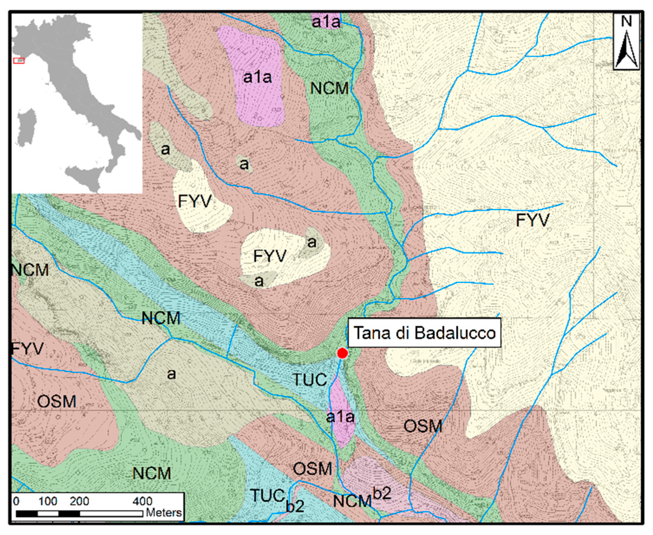
1.2. Environmental Context

The site is situated in the Nervia valley, on the southern border of the Colla Mirabello mountain [26] (Figure 3). The cave can be reached from the Rio Muratone river left bank, in the Marellae locality [5], approximately 35–40 km from the seacoast [26]. Despite its distance from the sea and the high elevation (665 m a.s.l.), the area is still subjected to a Mediterranean climate, to be more specific, to a Mediterranean to warm temperate mountains climate, characterized by relatively abundant rainfall and a mean annual temperature of 11 °C [27], which affects soils and their evolution.
The whole area is characterized by a complex karst system and a high number of caves [28]. The cave’s entrance is placed in correspondence to the Eocene limestone, at 18 meters from the creek level [6], not far from Giacheira cave [9], belonging to the same karst system (Figure 3). As has already been mentioned, Tana di Badalucco has formed at the contact between the Eocene limestone and the Upper Cretaceous marly limestone, both belonging to the Dauphinois–Provençal domain [29]. The second formation reported is the most represented in the study area [28]; it is called Trucco’s marls and marly limestones formation (TUC) (Figure 3). At its top can be found the Capo Mortola calcarenites formation (NCM), also known in literature as nummulite limestone, the name attributed for its richness in this Foraminifera genre [29]. In this area are also present two other formations worth mentioning: the Olivetta S. Michele silty marls (OSM) and the Ventimiglia flysch (FYV). The first develops above the NCM, with a gradual transition from one to the other, and it formed during the Lutetian and Bartonian Ages, while the second formed during the Bartonian and Priabonian [29].

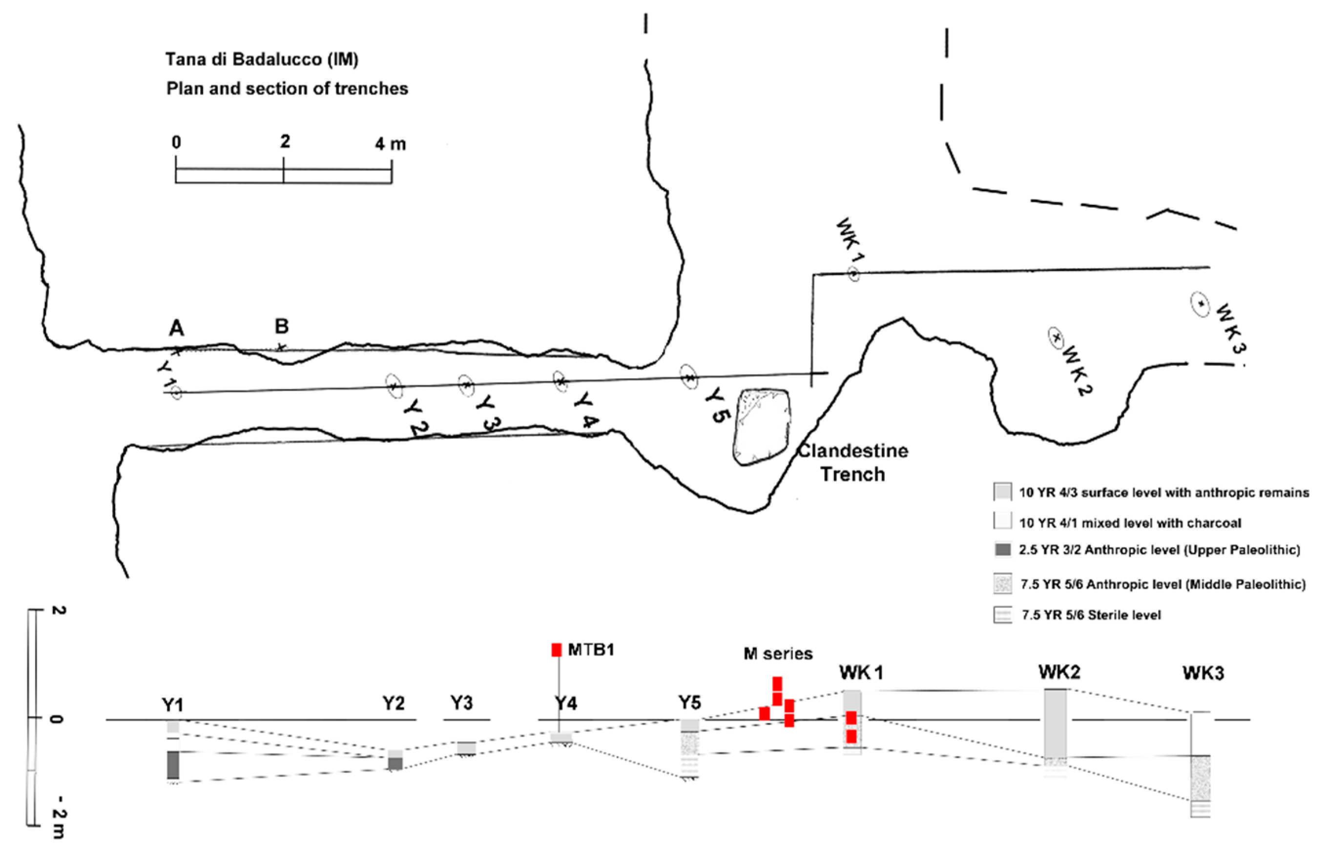
2. Materials and Methods

We will only discuss the micromorphological results on several selected thin soil sections, in order to underline the importance and great value of this technique.

2.1. Sampling

Sampling was performed by removing undisturbed sample blocks by excavating around the desired location and covering them with plaster [30]. This procedure was conducted in three different locations inside the cave: one sample (MTB1) (Figure 4a) was taken 4 m from the entrance in correspondence to an in situ deposit, 1 m above the ground surface. Five samples (M1–5) (Figure 4b) derived from a sequence of deposit situated just before the second corridor entrance: M4, 30 cm above the ground surface; M5, a few centimeters above the ground surface; M1, 5 cm below the ground surface; M2, 20 cm below; and M3, 40 cm. The last two (WK 1–2) belonged to a more internal Pleistocene deposit: WK1 was sampled 20–30 cm below the ground surface, WK2 30–35 cm below the ground surface.

2.2. Micromorphology

Micromorphology, as already stated, entails the study of intact soils, sediments, and associated archaeological materials (hearths, floors, and construction materials) at a microscopic scale [31]. Samples collected in the field were sent to the laboratory in Piombino (Massimo Sbrana–Servizi per la geologia), where they were dried, then impregnated with epoxy, and finally cut in slices, following the Benyarku and Stoops protocol [32]. These thin sections were then analyzed using a Leitz Laborlux 12 Pol microscope, with magnifications 2.5–50×, under plain polarized light (PPL), crossed polarizers (XPL), and oblique incident light (OIL). The description was performed borrowing principles and concepts from soil micromorphology and sedimentary petrography [32,33,34,35,36]; the same can be declared for what concerns interpretation [10,11,17,35]. For the descriptions, we used Stoops [33] and Macphail and Goldberg [17] guidelines, as well as some personal additions where it was considered convenient. Additionally, we adopted the terms suggested by Stoops [33] to describe sizes of fabric units, whereas we used Bullock [34] and Macphail and Goldberg [17] tables and charts for estimations and numerical data. We usually reported only the average size of features, unless it was considered more appropriate to indicate any relevant heterogeneity in the sample.

3. Results

We present the micromorphological description of the eight thin sections sampled in the cave with reference to field data.

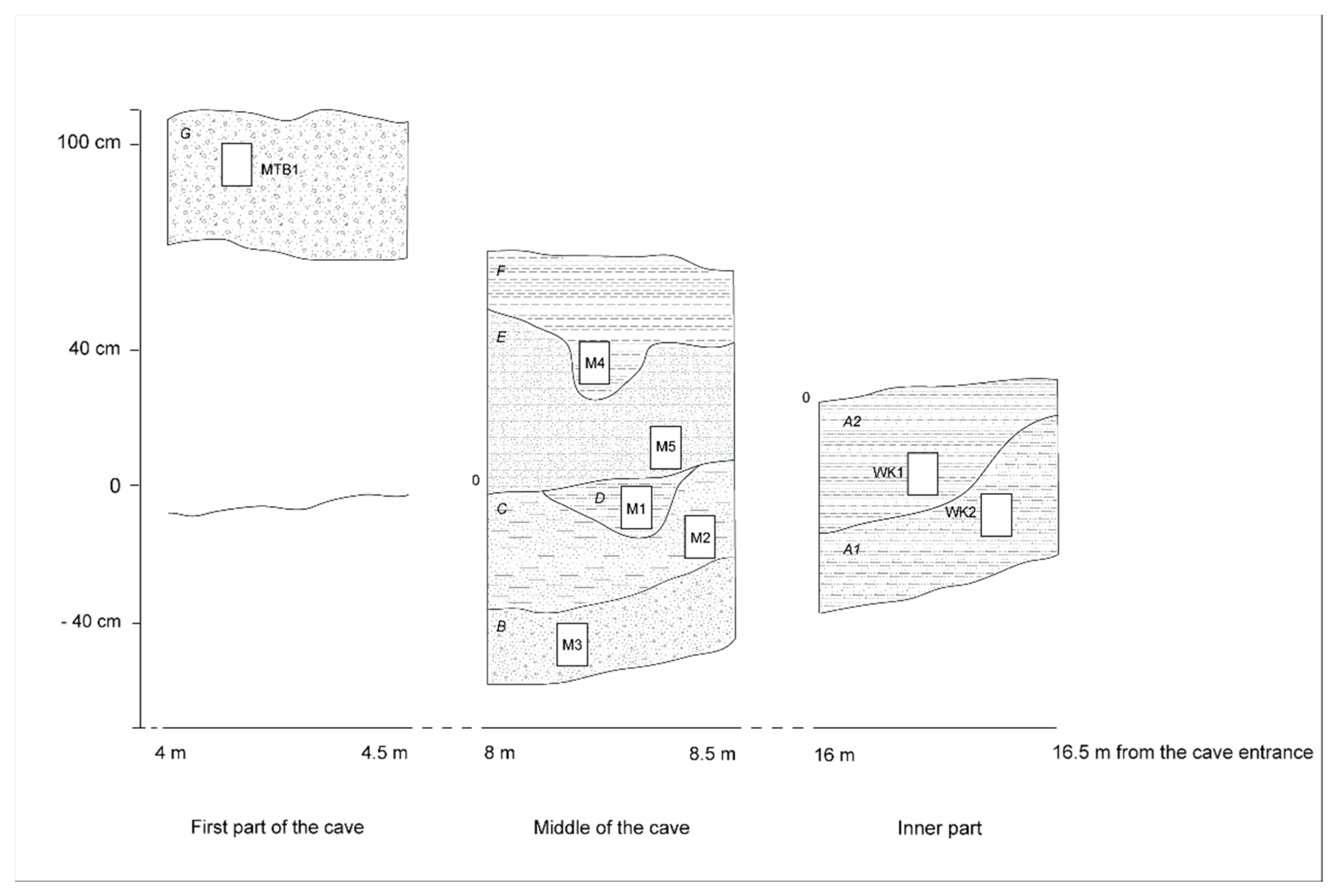
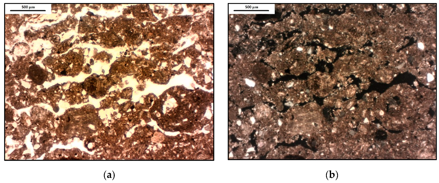
3.1. First Part of the Cave (Sample: MTB1)

It is a deposit in its original depositional setting, rich in bones, sampled one meter above the present ground surface. Other layers belonging, presumably, to the same period, had been removed during Zambelli’s excavations [6] at the beginning of the 1930s [4]. The microstructure has moderately separated subangular blocky, platy traits. Vughs and vesicles give a characteristic aspect to the whole sample (Figure 5). A few big fragments of highly altered limestone (up to 3 cm) are the only rock remains present; quartz shows two main size classes (fine sand and medium sand) and calcite appears only in a few grains (medium sand) affected by moderate to high alteration. Rare burnt and unburnt bones with moderate alteration (fine sand, f.s.) and a few fragments of highly altered charcoal (f.s.), as we expected from the field, are present. The micromass is a brown cloudy mixture of silt, clay, and little amounts of calcite, with weakly expressed (lightly striated, lightly crystallitic) b-fabric. There are occasional round Fe–Mn nodules with moderate alteration (f.s.) and rare round limpid phosphate-rich nodules with low alteration (f.s.).

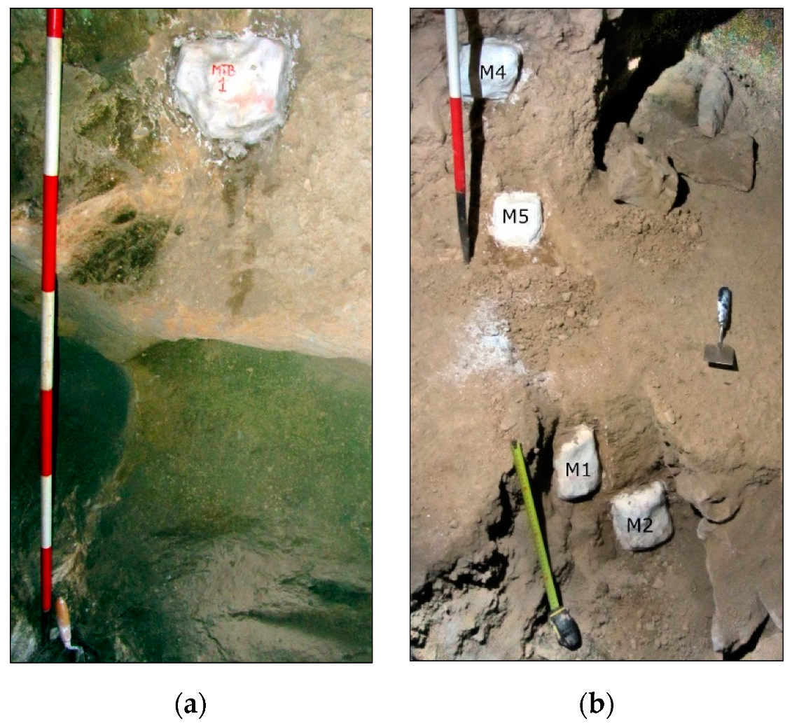
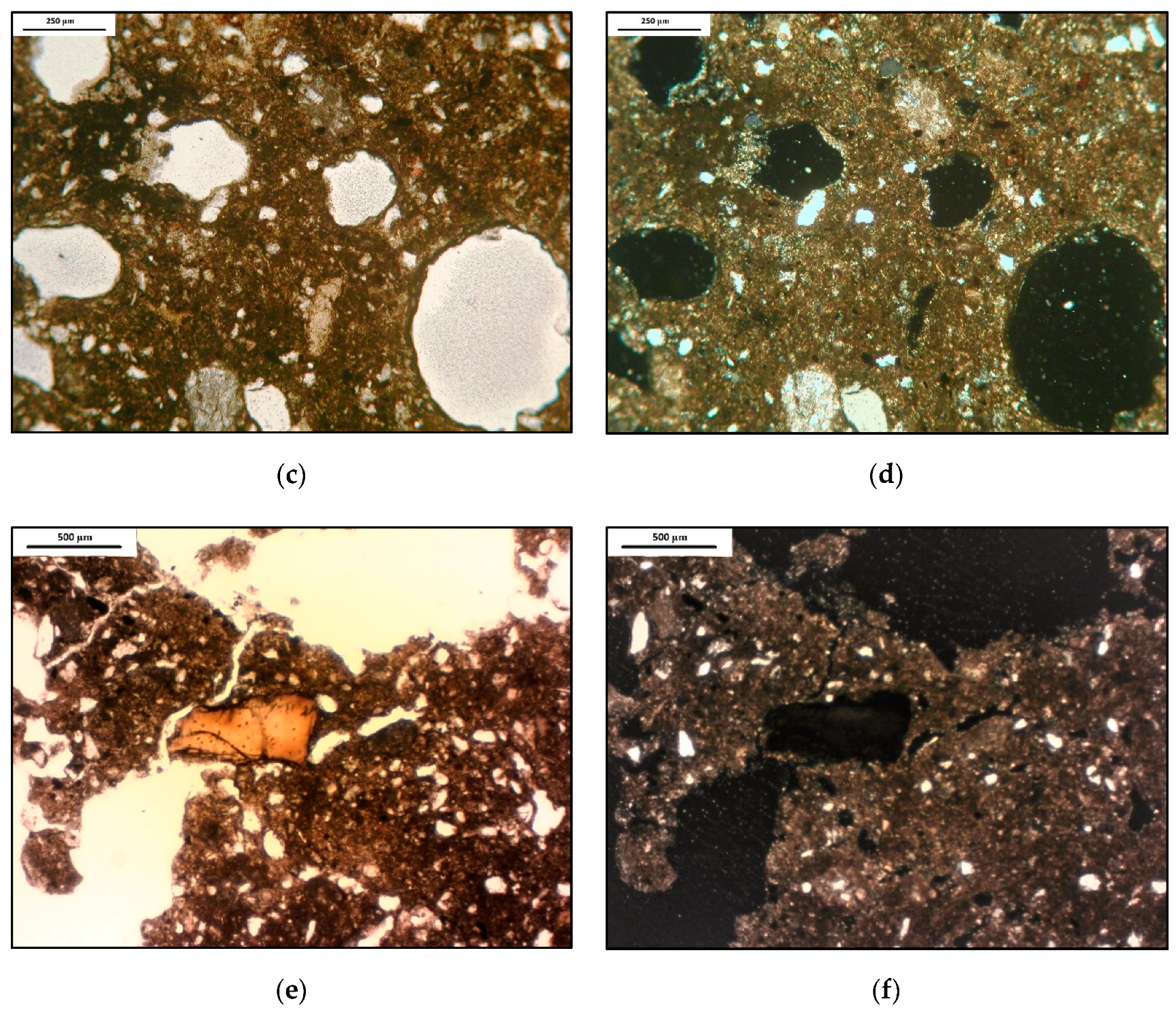
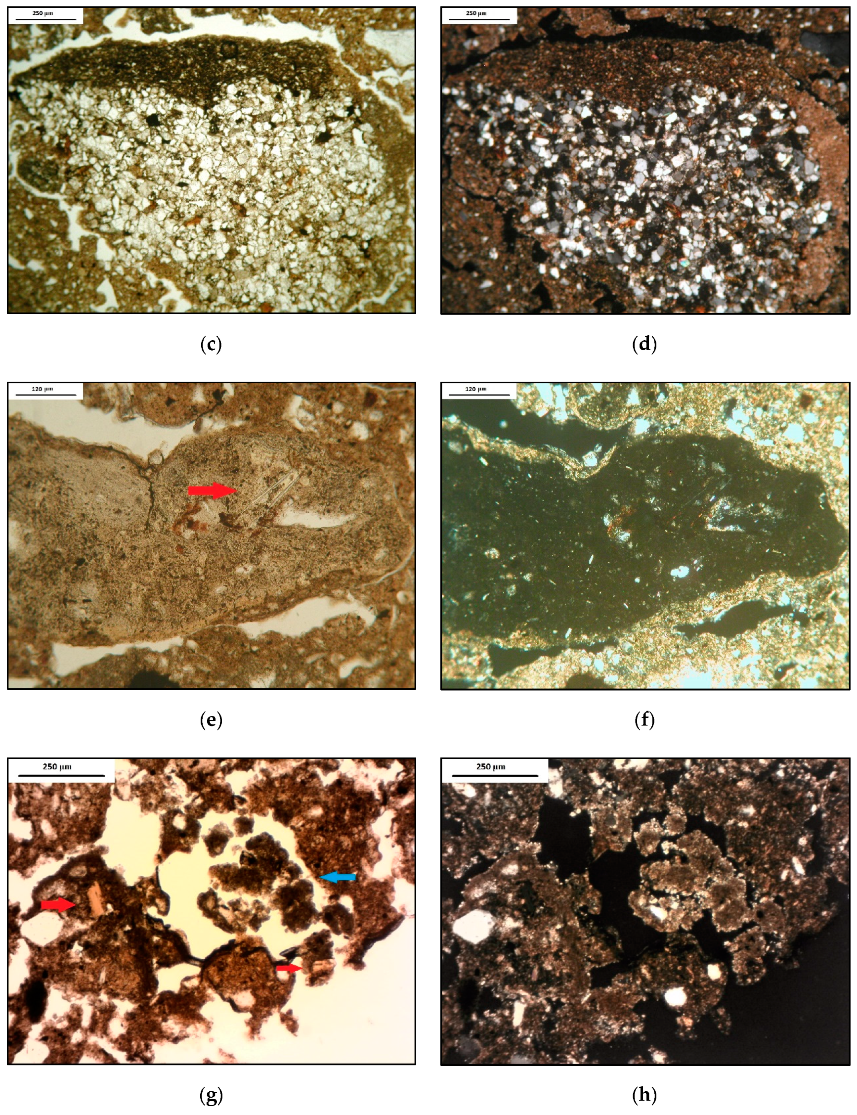
3.2. In the Middle of the Cave (the M Series, M1–M5)

Samples were collected before the entrance to the minor corridor. M4 and M5 were taken, respectively, 30 cm and a few centimeters above the ground surface, while the other three samples correspond to the portion below (M1, followed by M2 and M3) (Figure 6).
Subangular blocky microstructure traits are found in all samples, sometimes flanked by others, like massive (M5), crumb (M1 and M2), or platy (M3). The only mineral encountered is quartz, whose alteration decreases going downward along the section, from a moderate weathering to a light or no alteration at all, in the case of M3. An interesting characteristic relies on the presence in the inferior level (the already mentioned M3) of two different types of size and shape of these crystals: one finer (75 μm) and angular, the other bigger (120 μm) and rounded. Few rocky fragments are recognizable all along the exposed deposit: limestone is always represented, unlike sandstone, not appearing in the second and inferior samples. Altered coprolites can be found in every layer, with different alteration stages. In M4, it is possible to report the presence of coprolites typical of carnivores, due to the occurrence of a few bone fragments (f.s.) inside them. This feature is often associated with phosphate mottles, easily recognizable by their yellowish color in plane-polarized light and isotropic properties at crossed nicols. Burnt bones, very fine sand in size (except for two fragments of coarse sand size in M4), can be found in the upper and lower level, whereas unburnt are situated only in M1. Traces of charcoal and ashes are located in the topmost level and, in part, just below it, maybe because of truncated facies. In M4, an individual seed was found, indicating possible traces of burning. To conclude, ferrous nodules are widespread in the whole cave, without any exception. Clay pedofeatures can be seen from M5 and descending: in M1, clay coatings are fragmented, while in M2, they are just weathered, and in M3, there are signs of depletion. Interestingly, only M2 shows iron hypocoatings.

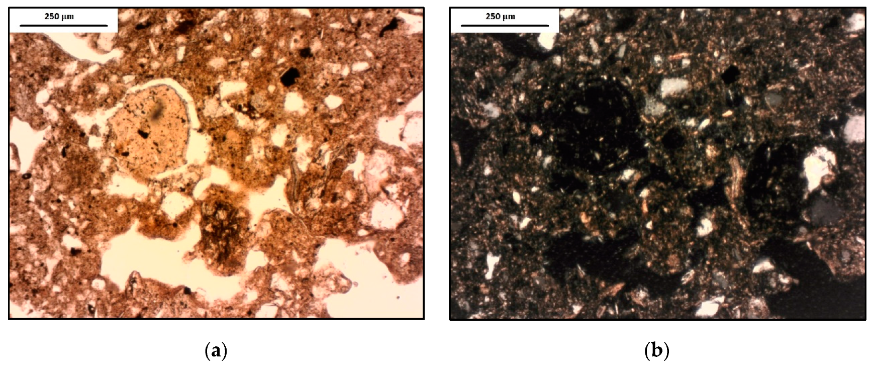
3.3. Inner Part (WK1, WK2)

Two sections were obtained from the deeper part of an internal infilling of the cave, below the ground surface. They belong to a deposit constituted of very rubified clayey silt. In this section, a Levallois scraper was found on this occasion, and many others had been found by Ricci in the 1960s [7] (Upper Pleistocene). Moreover, the sampling was conducted on one of Ricci’s trenches, from which, also, 91 instruments referable to the Middle Paleolithic were recovered [7].
The first sample (WK1, situated higher than the other) is composed of one big (5 × 4 cm) subangular blocky aggregate characterized by a fissure structure, while the second (WK2, situated below) shows a subangular blocky microstructure. The mineral portion, in both cases, is characterized by quartz, common and nonaltered (f.s.) and very few grains of unidentifiable minerals (due to the high state of alteration, f.s.). In the upper part of this layer, there are rare unburnt bones (f.s.) and rare Mn traces from what we suppose to be frutexites [37], as well as occasional highly reworked charcoal (f.s.). All these characteristics are not present downward. There are multiple examples of pedofeatures, mostly constituted of clay or iron, specifically clay infillings and opaque clay coatings, and ferrous hypocoatings. The number and size of these features grow descending the section.

4. Discussion

The thin soil section features are rather complex and related, like other geoarchaeological settings [38], to depositional and postdepositional processes of geogenic, biogenic, and anthropogenic character. Besides, each cave presents a combination of depositional environments sensitive to external climate factors, each one of them at different rates and magnitudes [20]. In this way, a various number of microsystems are created and, depending on the distance from the entrance of the cave and on other characteristics of the cave or of the region, they respond differently to processes [10,39]. Moreover, the collected samples are referable to a human frequentation covering an arc of at least 40,000 years, probably with some interruptions, during which many climatic changes took place.
In general, this cave witnessed different climate conditions and different agents influencing sediments. It has been affected by various events of freeze and thaw, as well as melting, conditions that have been strongly shaping the whole region. Human occupation can be traced back a long time ago, and the same goes for animals. Probably, wildlife and man alternated in time and space inside the cave. Nevertheless, more research is required to assert this without any doubt. We are, however, sure they did not exploit the whole cave and preferred the outer portions of it. A summary of micromorphological observations and inferences is presented in Table 1.

4.1. First Part of the Cave (Sample: MTB1)

The frost action is evident, particularly where the typical platy structure [11,38] (Figure 5a,b), as well as vesicles, can be observed (Figure 5c,d). This type of void is attributable to the expulsion of air present between ice crystals and soil peds [11]. Some zones show coarse material infillings perpendicular to the general level and silt cappings, another clear sign of freezing [11]. Zambelli [6] affirms that, for a long time, the cave had been inhabited only by animals, but we do not completely agree with him. The presence of burnt (Figure 5e,f) and unburnt bones, together with charcoal, indicate that the cave might have been used by man [19] before the important cold phase that affected this layer. However, as he states in his work [6], we find it likely that part of the cave had been inundated by limited flood events (presence of clasts and weathering), maybe associated with the fluviokarst stream system.

4.2. In the Middle of the Cave (the M Series, M1–M5)

This sector shows different representative episodes that affected almost the whole cave. Starting from the downmost layer, we have evidences of animals staying inside the cave shortly before, or during, cold climate stages, as coprolites (/phosphatic grains [19], mainly amorphous apatite, showing extinction) (Figure 6a,b) and unburnt bone fragments—altered and included in the micromass—make us suppose. Slowly, the frost action seemed to have become less intense. The high alteration of some minerals and rock fragments and the presence of depletion and hypocoatings point to a rehash of the whole material and, subsequently, to a great event of water passage and saturation that lasted for a long time [11]. Advancing under the ground surface, traces of frost action are evident once more. This is manifested referring, in particular, to the microstructure and to the accumulation of coarse material in correspondence to planar voids and silt cappings (Figure 6c,d). Coprolites are more numerous and easily recognizable where cryoturbation acted more strongly, indicating, for a second time, a probable use as a hibernation home for the duration of the cold period by carnivores [19] (Figure 6e,f), as also suggested by Ricci [40]. Moving upward, combustion traces were found (Figure 7), and we think it would be useful to examine this aspect in the future, maybe with further sampling and other methods of investigations. Alongside this, there are signs of a short arid interval (aeolian quartz deposits), as other archaeologists noticed [6], immediately replaced by more humid conditions (manganese stains, channels, clay pedofeatures), indicating an abrupt climate change [20]. The upper part clearly exhibits other combustion features (Figure 6g,h): this is indicated by the presence of burnt bones, charcoal, and ash, although in the field it was not so evident, probably because it underwent different events of weathering, presumably associated with the decay of organic materials and water passage [19]. The occurrence of limpid phosphatic nodules concentrated in close proximity to the bone fragments supports the hypotheses of different episodes disturbing the layers, related to organic decomposition, probably bioturbation or floods [19]. These characteristics of the samples may find a confirmation with what was observed in the Y5 test pit (Figure 1), which showed, in order: a first superficial deposit with anthropic remains and ceramic material for about 40 cm; a lower level characterized by a deposit apparently in its original depositional position, with anthropized traces; the deepest level, about 50 cm deep, in seemingly sterile soil.

4.3. Inner Part (WK1, WK2)

Previous archaeological excavations suggested great periods of water erosion in the valley and generally wetter conditions in the study area [6]. In the samples, we recognized a prior loess deposit (Figure 7a,b) transported inside the cave, associated with more arid conditions, later incorporated in the micromass (infillings and cappings). Numerous clay pedofeatures indicate, furthermore, more recent humid conditions [10,20], and, moving downwards, these elements increase in number. Clay pedofeatures (Figure 7c,d) become accompanied by ferrous hypocoatings and a good amount of iron in the matrix. All these signs point to wetter conditions [10] determined, maybe, by a rise in the water table and/or flood episodes, among other things (Goldberg, pers. comm., 2019). The Levallois scraper found in this inner portion of the cave [8] allows chronologically framing the deposit in the Middle-Upper Pleistocene, but more investigations are needed.

4.4. Tana di Badalucco Cave Deposits and Their Paleoclimatic Implications

Starting from the innermost parts of the cave and moving towards the entrance, more and more recent sediments are found. The Levallois scraper (typical of the Mousterian culture) permits chronologically framing the WK1-2 samples in the Middle-Upper Pleistocene.
The illuviation (clay coatings) and redoximorphic (iron hypocoatings) features, together with the strong rubefaction of some portions of the section, correspond to a warmer and more humid climate than the present day. Similar conditions in Italy are found during the Pleistocene interglacial phases, before the last glacial period (Eemian). In addition, this wet period may be responsible for significant flood episodes (testified by the presence of grains shaped by fluvial transportation and by the presence of layering, both evident in the field and in the thin section). These M deposits are more recent than the WK, thus we assume that they can be attributed to the Upper Pleistocene, and in particular, to the beginning of the last glaciation: along the stratigraphy, signs of freeze and thaw and alternation of more mild and humid phases (e.g., coarse illuviation) are evident and they are probably related to interstadials. The micromorphological evidence, in sample MTB1, indicates very cold and arid periglacial environments characterized by evidence of cryogenic features (microstructure, vesicles, Figure 5), probably dating back to the acme of the last glaciation (27∼18 ka BP).

5. Conclusions

The soil micromorphology has proven useful in giving more precise and targeted data. Although it is likely that no one methodological approach could hope to completely elucidate the complex arrangement of anthropogenic, biogenic, and geogenic elements deposited in this cave, micromorphological analysis provided information complementary to that gathered by traditional field and laboratory methods. Still, we have been able to enter more into detail and confront previous archaeological works, resulting in a more comprehensive understanding of the paleoenvironmental setting of the area. Moreover, we are able to confirm that the Badalucco cave was frequented both by man and animals, probably mainly carnivores, given the presence of coprolites containing hair. In fact, paleoclimatic events of a different nature have been recognized and, alongside, their influence on the whole region.
Concerning the WK1–2 and the M series samples, micromorphological interpretations and the previous archaeological knowledge seem to coincide. However, the position of the MTB1 sample, significantly above the current trampling surface, does not fit in with the sequence proposed in the previous archaeological works, identified as Holocene and crossed by the Zambelli excavations, whose materials are preserved in the various museums. The planned future interventions (dating, further micromorphological and stratigraphic analyses) will be aimed at solving these important issues. Here, we have presented our preliminary micromorphological study that helped in directing our interest and further research, as well as giving some initial, but meaningful, results that will be deepened in the future. In particular, further investigations, especially geochronological data, will be able to identify and describe the passage from an interglacial climate to an important and distinct cold stage referable to the last glaciation.

Author Contributions

Conceptualization, E.S., I.R., A.T., I.M., G.M., G.R. and M.F.; methodology, I.R., E.S.; formal analysis, E.S.; investigation, E.S., I.R., A.T., I.M., G.M., G.R. and M.F.; writing—original draft preparation, E.S.; writing—review and editing, E.S., I.R., A.T., I.M., G.M., G.R. and M.F.; supervision, X.X.; funding acquisition, M.F.

Acknowledgments

We would like to thank Fabio Bona for raising doubts about the validity of previous paleozoological data and Paul Goldberg for his suggestions.

Conflicts of Interest

The authors declare no conflict of interest.

References

  1. Mercuri, A.M.; Allevato, E.; Arobba, D.; Bandini Mazzanti, M.; Bosi, G.; Caramiello, R.; Castiglioni, E.; Carra, M.L.; Celant, A.; Costantini, L.; et al. Pollen and macroremains from Holocene archaeological sites: A dataset for the understanding of the bio-cultural diversity of the Italian landscape. Rev. Palaeobot. Palynol. 2015, 218, 250–266. [Google Scholar] [CrossRef] [Green Version]
  2. Barham, A.J.; Macphail, R.I. (Eds.) Archaeological Sediments and Soils: Analysis, Interpretation and Management; Routledge: New York, NY, USA, 2016. [Google Scholar]
  3. Branch, N.P.; Black, S.; Maggi, R.; Marini, N.A.F. The Neolithisation of Liguria (NW Italy): An environmental archaeological and palaeoenvironmental perspective. Environ. Archaeol. 2014, 19, 196–213. [Google Scholar] [CrossRef]
  4. Molinari, I.; Montinari, G.; Rossi, G. Grotta Torello/Tuvetto o Tana di Badalucco, Pigna (IM)-Un Contesto Disperso; Archeologia in Liguria, Volume V; Conventi, M., Del Lucchese, A., Gardini, A., Eds.; SAGEP: Genova, Italy, 2012. [Google Scholar]
  5. Calandri, G.; Crippa, C.; Ramella, L. Lo Sgarbu di Barraico in val Nervia (Provincia di Imperia). Riviera dei Fiori. Rivista della Camera di Commercio di Imperia 1979, 12, 3–13. [Google Scholar]
  6. Hosmer Zambelli, F. La Tana di Badalucco nella Liguria Occidentale. Le Grotte d’Italia 1934, XII, 1–11. [Google Scholar]
  7. Ricci, M. Pigna nella preistoria. In Pigna e il suo Territorio; Cartoguide De Agostini: Roma, Italy, 1988; p. 21. [Google Scholar]
  8. Sandgathe, D.M.; Dibble, H.L.; Goldberg, P.; McPherron, S.P. The Roc de Marsal Neandertal child: A reassessment of its status as a deliberate burial. J. Hum. Evol. 2011, 61, 243–253. [Google Scholar] [CrossRef] [PubMed]
  9. Bianchi, N.; Rellini, I.; Traverso, A.; Pigna, A. Grotta Giacheira e Tana di Badalucco: La ripresa delle ricerche. Archeol. Liguria 2015, V, 128–130. [Google Scholar]
  10. Courty, M.-A.; Goldberg, P.; Macphail, R. Soils and Micromorphology in Archaeology; Cambridge University Press: Cambridge, UK, 1990; ISBN 978-0-521-32419-9. [Google Scholar]
  11. Stoops, G.; Marcelino, V.; Mees, F. Interpretation of Micromorphological Features of Soils and Regoliths; Elsevier: Amsterdam, The Netherlands, 2010; ISBN 978-0-08-093230-9. [Google Scholar]
  12. Kubiena, W.L. Micropedology; Collegiate Press, Inc.: Ames, IA, USA, 1938. [Google Scholar]
  13. Rellini, I.; Trombino, L.; Carbone, C.; Firpo, M. Petroplinthite formation in a pedosedimentary sequence along a northern Mediterranean coast: From micromorphology to landscape evolution. J. Soils Sediments 2015, 15, 1311–1328. [Google Scholar] [CrossRef]
  14. Vogel, S.; Märker, M.; Rellini, I.; Hoelzmann, P.; Wulf, S.; Robinson, M.; Steinhübel, L.; Di Maio, G.; Imperatore, C.; Kastenmeier, P.; et al. From a stratigraphic sequence to a landscape evolution model: Late Pleistocene and Holocene volcanism, soil formation and land use in the shade of Mount Vesuvius (Italy). Quat. Int. 2016, 394, 155–179. [Google Scholar] [CrossRef]
  15. Nicosia, C.; Stoops, G. Archaeological Soil and Sediment Micromorphology; John Wiley & Sons: Hoboken, NJ, USA, 2017; ISBN 978-1-118-94105-8. [Google Scholar]
  16. Ismail-Meyer, K.; Rentzel, P.; Wiemann, P. Neolithic Lakeshore Settlements in Switzerland: New Insights on Site Formation Processes from Micromorphology. Geoarchaeology 2013, 28, 317–339. [Google Scholar] [CrossRef]
  17. Macphail, R.I.; Goldberg, P. Applied Soils and Micromorphology in Archaeology; Cambridge University Press: Cambridge, UK, 2017; ISBN 978-1-108-50858-2. [Google Scholar]
  18. Karkanas, P.; Goldberg, P. 6.23 Micromorphology of Cave Sediments. In Treatise on Geomorphology; Elsevier: Amsterdam, The Netherlands, 2013; ISBN 978-0-08-088522-3. [Google Scholar]
  19. Goldberg, P.; Schiegl, S.; Meligne, K.; Dayton, C.; Conard, N.J. Micromorphology and Site Formation at Hohle Fels Cave, Swabian Jura, Germany. Available online: https://www.eg-quaternary-sci-j.net/53/1/2003/egqsj-53-1-2003.pdf (accessed on 6 May 2019).
  20. Courty, M.-A.; Vallverdu, J. The microstratigraphic record of abrupt climate changes in cave sediments of the Western Mediterranean. Geoarchaeology 2001, 16, 467–499. [Google Scholar] [CrossRef]
  21. Woodward, J.C.; Goldberg, P. The sedimentary records in Mediterranean rockshelters and caves: Archives of environmental change. Geoarchaeology 2001, 16, 327–354. [Google Scholar] [CrossRef]
  22. Rellini, I.; Firpo, M.; Martino, G.; Riel-Salvatore, J.; Maggi, R. Climate and environmental changes recognized by micromorphology in Paleolithic deposits at Arene Candide (Liguria, Italy). Quat. Int. 2013, 315, 42–55. [Google Scholar] [CrossRef]
  23. Lowe, J.J.; Walker, M.J.C. Reconstructing Quaternary Environments; Routledge: Abingdon-on-Thames, UK, 2014; ISBN 978-1-317-75371-1. [Google Scholar]
  24. Issel, A. Liguria: Geologica e Preistorica; Donath, A., Ed.; A. Forni: Genova, Italy, 1892. [Google Scholar]
  25. Issel, A. Liguria Preistorica. Donath, A., Ed.; Società ligure di Storia Patria: Genova, Italy, 1908. [Google Scholar]
  26. Chiarenza, N. 16 Mountains and shore: sites and communication routes of Copper Age western Liguria. In Hidden Landscapes of Mediterranean Europe - Cultural and Methodological Biases in Pre-and Protohistoric Landscape Studies 133; BAR International Series: Siena, Italy, 2011. [Google Scholar]
  27. Costantini, E.A.C.; Fantappié, M.; L’Abate, G. Climate and Pedoclimate of Italy. In The Soils of Italy; Costantini, E.A.C., Dazzi, C., Eds.; World Soils Book Series; Springer Netherlands: Dordrecht, The Netherlands, 2013; pp. 19–37. ISBN 978-94-007-5642-7. [Google Scholar]
  28. Calandri, G.; Camprendon, R. Geologia e carsismo dell’Alta Val Nervia e Argentina (Liguria occidentale): Guida escursione; Comune di Imperia. Assessorato alle attività culturali; Gruppo speleologico imperiese C.A.I.: Imperia, Italy, 1982. [Google Scholar]
  29. Dallagiovanna, G.; Fanucci, F.; Pellegrini, L.; Seno, S.; Bonini, L.; Decarlis, A.; Maino, M.; Morelli, D.; Toscani, G. Carta Geologica alla scala 1:25,000 Foglio 257 “Dolceacqua” e Foglio 270 “Ventimiglia” con note illustrative. CARG 2012, 257, 1–76. [Google Scholar]
  30. Miller, C.; Conard, N.; Goldberg, P.; Berna, F. Dumping, Sweeping and Trampling: Experimental Micromorphological Analysis of Anthropogenically Modified Combustion Features. Faculty of Science, Medicine and Health-Papers: Part A. 2010. Available online: https://ro.uow.edu.au/cgi/viewcontent.cgi?referer=https://www.google.com.hk/&httpsredir=1&article=4103&context=smhpapers (accessed on 6 May 2019).
  31. Goldberg, P.; Sherwood, S.C. Deciphering human prehistory through the geoarcheological study of cave sediments. Evol. Anthropol. Issues News Rev. 2006, 15, 20–36. [Google Scholar] [CrossRef]
  32. Benyarku, C.A.; Stoops, G. Guidelines for Preparation of Rock and Soil Thin Sections and Polished Sections; Departament de Medi Ambient i Ciències del Sòl, Universitat de Lleida: Lleida, Spain, 2005. [Google Scholar]
  33. Stoops, G. Guidelines for Analysis and Description of Soil and Regolith Thin Sections; Soil Science Society of America: Madison, WI, USA, 2003. [Google Scholar]
  34. Bullock, P. Handbook for Soil Thin Section Description; Waine Research: Wolverhampton, UK, 1985. [Google Scholar]
  35. FitzPatrick, E.A. Micromorphology of Soils; Springer Science & Business Media: Amsterdam, The Netherlands, 2012; ISBN 978-94-009-5544-8. [Google Scholar]
  36. Brewer, R. Fabric and Mineral Analysis of Soils; Wiley: Oxford, UK, 1964. [Google Scholar]
  37. Rodríguez-Martínez, M.; Heim, C.; Quéric, N.-V.; Reitner, J. Frutexites. In Encyclopedia of Geobiology; Reitner, J., Thiel, V., Eds.; Springer: Dordrecht, The Netherlands, 2011; pp. 396–401. ISBN 978-1-4020-9211-4. [Google Scholar]
  38. Karkanas, P.; Goldberg, P. Reconstructing Archaeological Sites: Understanding the Geoarchaeological Matrix; John Wiley & Sons: Hoboken, NJ, USA, 2018; ISBN 978-1-119-01643-4. [Google Scholar]
  39. Karkanas, P.; Goldberg, P. Cave Settings. In Encyclopedia of Geoarchaeology; Gilbert, A.S., Ed.; Springer: Dordrecht, The Netherlands, 2017; pp. 108–118. ISBN 978-1-4020-4409-0. [Google Scholar]
  40. Ricci, M. Grotte de Badalucco. In Les Premiers Peuplements de la Còte d’Azur et de la Ligurie; De Lumley, H., De Lumley M., A., Eds.; Melis: Nice, France, 2011; Volume Tome I, pp. 92–93. ISBN 2-35210-068-2. [Google Scholar]
Figure 1. Map of Tana di Badalucco cave.
Geosciences 09 00276 g001
Figure 2. Stratigraphy with the sedimentological layers, as well as sampling locations. The blank portions were not excavated due to the presence of boulders and the absence of original deposits. A1–A2: rubified clayey silt; B: brown silt; C: brown loamy clay; D: grey loam; E: firm grey silt; F: light brown clay; G: roofspall and bone-rich breccia.
Geosciences 09 00276 g002
Figure 3. Geology of the study area. FYV: Ventimiglia flysch; NCM: Capo Mortola calcarenites formation; OSM: Olivetta S. Michele silty marls; TUC: Trucco’s marls and marly limestones formation.
Geosciences 09 00276 g003
Figure 4. Sampling in the first part (a) and in the middle of the cave (b).
Geosciences 09 00276 g004
Figure 5. Microphotographs of some relevant features in MTB1. (a,b) The platy structure and the presence of peculiar voids point to frost action conditions in sample MTB1 (PPL in a., XPL in b). (c,d) Microphotograph of a frost-related type of void: vesicles. They are easily recognizable thanks to their characteristic well-rounded shape and regular smooth surface. (e,f) Microphotograph of some combustion traces: in the center, a burnt bone fragment, and in the micromass are evident a few little charcoal remains.
Geosciences 09 00276 g005aGeosciences 09 00276 g005b
Figure 6. Microphotographs of some relevant features from the M series thin sections. (a,b) Microphotograph of slightly lighter, yellow-colored phosphatic grain (probably a coprolite) affected by cryoturbation, showing extinction in XPL (b). It is also evident how cold influenced the micromass. (c,d) Microphotograph of a silt capping above a rock fragment. (PPl in c, XPL in d). (e,f) A well-preserved carnivorous coprolite. The red arrow indicates a hair inside the phosphate-rich feature. (g,h) Microphotograph of some combustion traces: the two red arrows indicate the presence of small burnt bone fragments, the blue arrow a few altered ash grains.
Geosciences 09 00276 g006aGeosciences 09 00276 g006b
Figure 7. (a,b) Microphotograph of a previous loess deposit and of silty clay parallel laminated coatings (PPL in a, XPL in b). (c,d) Microphotograph of a loess deposit, incorporated in the micromass, and limpid, parallel laminated dark clay coatings. Their color indicates the presence of iron and manganese. These features (loess deposit and clay coatings) indicate, respectively, an arid climate stage followed by a more humid event.
Geosciences 09 00276 g007
Table 1. Summary of micromorphological observations and inferences.
Portion of the CaveSampleThicknessMain FeaturesInferences
First part of the caveMTB1+100 cmSubangular blocky-platy microstructure, burnt and unburnt bones, charcoal.Cold climate stage. Human occupation.
MiddleM4+30 cmBurnt bone fragments, charcoal, ashes.Signs of combustion and strong weathering.
-M5+5 cmReworked ashes and charcoal.A truncated sequence of different occupied surfaces.
---Angular quartz grains and calcitic features in contact with clay pedofeatures and Fe hypocoatings.Short arid interval replaced by humid conditions.
-M1−10 cmCrumbs, vughs, and unburnt bones.Probable use as a den for the cold period.
-M2−20 cmCrumbs, high alteration, clay pedofeaturesFreeze and thaw, water passage.
-M3−40 cmPlaty microstructure, accumulation of coarse material in correspondence to planar voids.Cold climate stage. Animal occupants.
Inner partWK1−20 cmPrior loess deposits. High state of alteration, unburnt bones, rare Mn traces. Arid situation replaced by humid conditions, flood events, rise of the water table.
-WK2−30 cmPrior loess deposits. More clay and iron pedofeatures.As above, but with a more prolonged stagnation.

