Article

Geomorphological Evolution of the Sena Gallica Site in the Morpho-Evolutive Quaternary Context of the Northern-Marche Coastal Sector (Italy)

Department of Pure and Applied Sciences, University of Urbino ‘Carlo Bo’, 61029 Urbino, Italy
*
Author to whom correspondence should be addressed.
Geosciences 2019, 9(6), 272; https://doi.org/10.3390/geosciences9060272
Submission received: 14 May 2019 / Revised: 14 June 2019 / Accepted: 17 June 2019 / Published: 21 June 2019
(This article belongs to the Special Issue Geoarchaeology: A Review of Case Studies in the Mediterranean Sea)

Abstract

:
The Sena Gallica Roman town was settled on the Adriatic coast in the 5th to 4th century BC. The choice of the site was largely influenced by the geomorphological and physiographic conditions near the Misa river mouth. The interactions among climate variation, river dynamics, and marine oscillation determined the anthropic development. At the same time, the new settlement strongly influenced the evolution of this sector in both medieval and in recent times. This work aims to highlight the geological setting and geomorphological evolution of the Senigallia area within the Northern Marche region, taking into account the main scientific literature and new studies to propose a new interpretation of the Holocene history.

1. Introduction

Senigallia (Civium Romanorum of Sena Gallica) was the first Roman colony to settle in the Adriatic coastal district. It is located on the coastal plain on the right bank of the Misa river in a mildly raised area with the actual historical center of Senigallia being situated at a distance of 700 to 350 m from the shoreline (Figure 1). It was formerly occupied by pre-Roman populations, and has been settled since the 5th to 4th century BC. [1,2,3].
The choice of settlement location was influenced by the unique geomorphological configuration of the area, which includes favorable physiographic and hydrographic characteristics on the coastal plain/river mouth. The area is characterized by gently raised and protected areas and enclosed by waterways, coastal ponds, and the sea [2].
The current-day presence and configuration of the coastal depositional plain (on which Senigallia rises) and of the various geomorphological and morpho-sedimentary elements are related to straight sea-slopes, coastal and valley terraces, and their plano-altimetric distribution. The Marche coast has undergone remarkable and radical changes in the recent geological past. In fact, today’s coastal zone has a composite character that is heterogeneous from a sedimentation and morpho-evolutionary point of view. It consists of continental clastic sediments, mainly alluvial, coastal, and transitional environments of the Pleistocene Holocene [5], laid on a substrate shaped by marine erosion [6]. The pre-Quaternary geology is mainly based on close areas, such as in the Sant’Angelo/Scapezzano anticline that constitutes the hills just behind the city of Senigallia (Figure 1). Along this middle Pliocene Apenninic fold, interpreted as a result of a blind thrusting and a triangular zone [7], some outcrops (i.e., San Gaudenzio quarry) show the Miocene–Pliocene foredeep succession [8] from the Schlier (lower Tortonian–Messinian p.p.) to Argille Azzurre (lower Pliocene–lower Pleistocene p.p.) formations (Figure 1).
In recent years, multidisciplinary archaeological and geological-geomorphological studies involving research groups from the University of Bologna and Urbino have highlighted the strong interconnections and mutual influences between natural processes, human activity, and the main features of the recent morphological evolution of this area. Given negligible local coastal uplift values [9,10,11], the principal factors affecting, in late Quaternary times, the coastal evolution in the study areas are sea-level glacio-eustatic fluctuations modulated by principal glacial–interglacial cycles [12,13]. In the second half of the Holocene, the main causes of the fluvial and coastal evolution can be related to changes in sediment load as a response to forest clearing [14] and/or to minor climatic fluctuations (e.g., the Little Ice Age) [10,15].
These studies show that Romans implemented important changes on the natural conditioning of the paleo-morphology of the urban fabric of Sena Gallica to adapt the site configuration for defensive settlement and trade purposes [2,15,16,17].
The main scope of this work is a comprehensive interpretation of the Quaternary and historic evolution of the Senigallia area framed in the larger sector of the Northern Marche coastal area coming from previous studies. Regarding the evolution of the recent plain, most authors (e.g., [14,18,19,20]) have proposed anthropogenic causes (land use, alteration of river dynamics, etc.). In this article, together with the anthropic impact, we prioritize, where possible, natural causes, especially climatic ones. New surveys and different approaches (archaeology and geological-geomorphological sciences) propose new discoveries and interpretations (i.e., alluvial fan wave-cutting, berms depositions, gullies development) of this sector of the Adriatic coast.

2. Study Methods and Materials

The work, carried out for many years in collaboration with archaeologists, is a new synthesis and interpretation derived from previous field and lab works, unpublished data (partial geomorphological and archaeological notes never merged into a single summary), and revision of information derived from the literature. As the work is a synthesis of the data collected during the last years of multidisciplinary researches, including mainly geologic, geomorphologic, geophysics, and archeologic approaches, the used methods and materials are not illustrated in detail. We synthesized them as:
(1)
The subsurface geology data of Senigallia were sourced mainly from the direct field work mapping the surrounding areas, taking also into account the CARG (Cartografia Geologica Regionale; Geological Cartography of Italy) maps (scale of 1:50,000) and Marche region geological maps (scale of 1:10,000). Most of those surveys were supported by digital tools (tablet pc and GPS receivers) with mobile GIS (QGIS (Quantum Geographic Information System) freeware software with ad-hoc developed plug-ins) [7].
(2)
The geomorphological settings of the surrounding sectors where the Senigallia area is framed is the result of previous studies (see further chapters for bibliography). In particular, the alluvial fans reconstructions and the shoreline variations were based on field work, e.g., [4], and aerial photographs’ analysis (starting from the G.A.I. (Gruppo Aeronautico Italiano) historical photos of the IGMI-Istituto Geografico Militare Italiano, dating back to 1954–1956 up to recent images), historic cartography (see further chapters), fieldwork, probes radiocarbon dating, and geostatistical analysis [11].
(3)
The geophysical prospectings represent important contributions to the dataset of this work. Resistivity, seismic, ground penetrating radar, and electromagnetic techniques were exploited to capture information in the urban area where non-invasive methods were required. The interpretations of the geophysical data set were validated with a number of probes. The geognostic dataset of 86 mechanical continuous probing and 30 standard penetrations tests (from the database of the Senigallia municipality) were integrated with 21 hand probings (carried out by archaeologists) in some sectors of greater interest or where data were missing [17].
(4)
The archaeological excavations and the analysis carried out by archaeologists provided new timing data and sedimentological information which improved and detailed the interpretation of the evolution mainly of the Senigallia area.
The final geoarchaelogical maps were also interpreted and synthesized with GIS and 3D modelling software [15,16,17].

3. Geomorphological Evolution

3.1. Geomorphology and Holocene Evolution of the Coastal Plain

The Northern coast of the Marche region has an NW–SE orientation, is 60 km long, and is characterized by a depositional plain up to 1.2 km wide.
The coastal plain ends against the rocky cliffs of Mt. Conero (SE) and Mt. San Bartolo (NW) and includes the mouths of the main rivers (from north to south: Foglia, Metauro, Cesano, Misa, and Esino), which, approaching the coastline, show an almost orthogonal trend with respect to the shoreline (Figure 1).
Between the cities of Fano and Falconara, the coastal plain joins the river floodplains and/or ends abruptly against the slopes of the coastal hills. Towards the sea, the shore connects directly with the sandy-gravelly beaches, which extend under the marine surface at up to 10 to 11 m u.s.l.
On a regional scale, the transition from the foothills to the Adriatic basin has a fundamental geodynamic value of transition from the tectonic uplift of the Apennine/foothills sector to the subsidence of the Padano–Adriatic area [21].
It should be noted, however, that the hills and coastal plain are affected by a very small tectonic uplift (0.15 mm a−1; [9,10,20]), with small effects on the Pleistocene–Holocene morphological evolution of the area.
The main factors that influenced the morphology were the Quaternary glacial–interglacial climatic variations and the effects they had on the sea level (glacio-eustatic oscillations), coastal processes, and relief and river processes.
During the late Quaternary period, the Central-Northern Adriatic shallow sea (maximum 50–70 m; [12]) underwent repeated emergence events due to glacio-eustatic lowering of the sea level, extending the Po plain up to Pescara [13,22]. During the last glacial maximum (LGM), the sea level fell by 120 to 130 m on the global scale [23]. For the Adriatic sea, values of 110 to 120 m [24] are commonly accepted.
One effect of these prolonged emersion episodes was a river network extension on the Adriatic platform. Therefore, Northern Marche rivers have become tributaries of the “paleo-Po“ [25,26].
During the first glacial phases, the eustatic lowering also led to the formation of engraved valleys, up to tens of meters below the present sea level, which, during colder phases, although still under low sea level conditions, were filled by alluvial sediments.
Evidence of the occurrence of incised paleo-valleys extending the current river mouths on the Adriatic platform is shown by the base of the alluvial deposits, which lies below the current sea level at depths even above 50 m. The restoration of temperate interglacial conditions cyclically raised the sea level lapping the coastal hills to a position comparable to the present one [27].
During the Middle and Upper Pleistocene period, the coastal reliefs of Mt. San Bartolo and Mt. Conero were extended more towards the sea. During the interglacial phases, the sea reached them again and the erosion made them retreat, reshaping cliffs and platforms [28,29]. The Holocene retreat estimated for Mt. San Bartolo [30] of an average rate of about 0.5 m/year provides a realistic indication of the mean value of sea erosion on the two “capes” during the interglacial episodes.
However, the interglacial retreat affected only the “prominent” coastal sectors—Mt. Conero, Mt. San Bartolo, and Mt. Ardizio—not the area between the mouths of the Metauro and Esino rivers, whose “interglacial position“ has remained stable since at least the middle Pleistocene period.
From the Middle–Upper Pleistocene up to the Holocene, the interrelations between the middle-Pleistocene valley and coastal terraces show the maintenance of the “interglacial position“ of the mouths of the Misa and Cesano rivers, associated with slight variations in the geomorphological structure of the coast under high sea conditions [28].
Therefore, in this area, the sub-rectilinear morphological structure, characterizing hilly slopes facing the sea and probably part of the inner sectors of the coastal plain itself, can be traced back to the Middle Pleistocene period, although the real presence and consistency of pre-Holocene morpho-sedimentary “relics“ are still to be verified.
Elmi et al. [6] pointed out the almost straight course of the seaward hill slopes in the coastal sector between Gabicce and Ancona. These slopes now stand at about 2 km inland from the shore, separated by the coastal plain, with the whole slope facing to the sea like a strongly reshaped marine cliff.
These authors attribute the origin of the cliff to the maximum Holocene marine transgression (“Flandrian shore“), thus fixing the innermost position reached by the post-glacial shoreline in the interfluvial areas near the hills. Although formally correct, this interpretation does not take two main elements into account:
  • The slope is much older and probably polyphasic. The geometry of the Middle Pliocene terraces suggests that the shoreline has approached it during at least two other previous interglacial episodes [28].
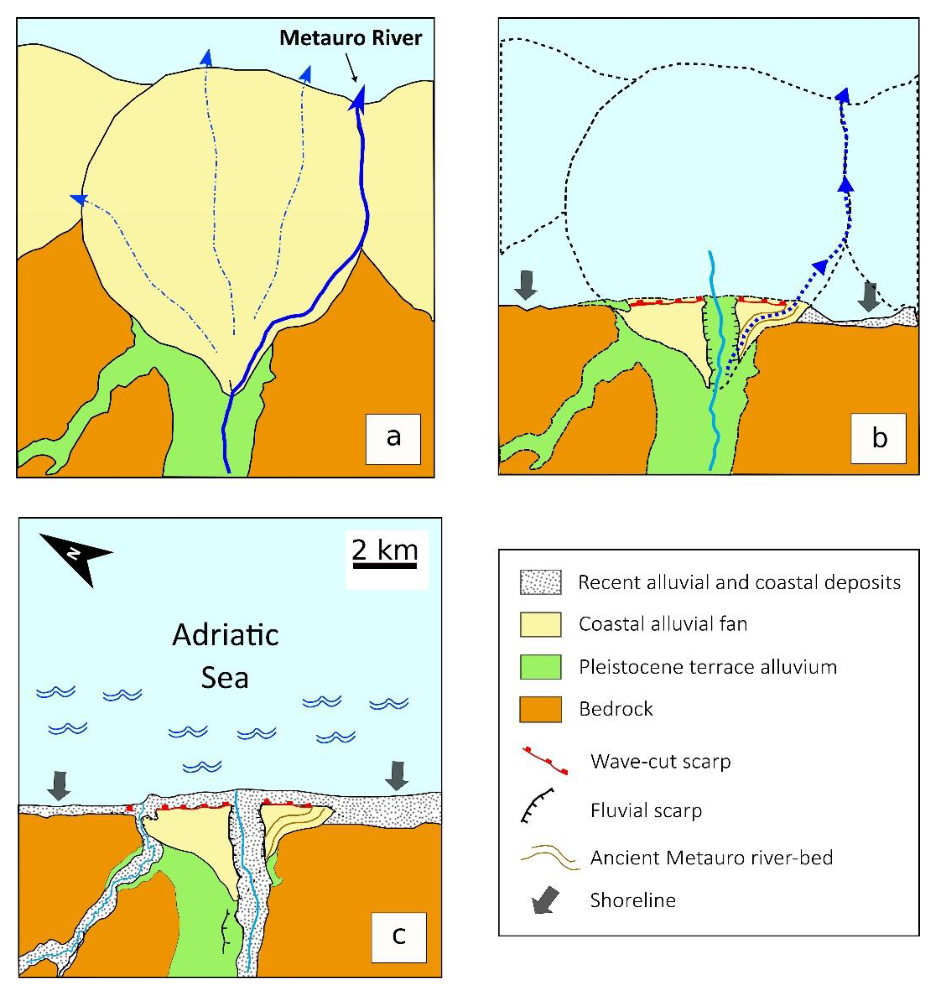
  • The “Flandrian shore“ cannot coincide with the slope along all of its extension. In fact, the coastal Metauro and Cesano alluvial fans (here described at point 3.1.1), which are still well preserved in their apical portions, “protect“ rather extensive slope segments and/or “lean“ on them by covering them.
Even without specific proof, the presence of large gulfs between the Metauro and Cesano rivers is more plausible during maximum Holocene transgression (such as between Cesano and Misa, cf. [14]), similar to those outlined by [19] for areas far from river mouths.
In any case, due to the “interglacial return“ of shorelines to a specific position and the multiple minor oscillations straddling this position, the evolution of the coastal plain has certainly been marked by a complex series of local and generalized ingression and regression episodes. Episodes still known by their traces are extremely labile, extensively eroded, and/or masked by Holocene deposits.
The morphological–stratigraphic correlation (“by altimetric analogies,“ [14]) hypothesized between the inner area of the coastal plain with the Middle Pleistocene alluvial terraces of the Misa river is quite interesting. This interpretation agrees with points 1 and 2, and with the presence of pre-Holocene deposits at the Cesano mouth [31], reinforcing the hypothesis of the presence of deposits connected with the “Tyrrhenian“ transgression in this area.
From a geomorphological point of view, the morphological evolutionary complexity of the coastal plain is associated with that of the lower segments of the valleys. Here, four distinct levels of alluvial terraces of the middle Pleistocene–Holocene period are present as consequences of the combined effects of the main climatic variations of the middle Pleistocene–Holocene period with those of the Apennine uplift.
Minor accumulation and erosion events (also involving the formation of secondary terraces) caused by climatic, eustatic, and anthropic changes in river regimes or marine erosive-depositional action further complicate the morphology of the nearshore valley reaches [32]. However, regardless of the complexity in the space–time succession of erosive and depositional processes (and terracing), towards the mouth of the present rivers, from morphological and sedimentary points of view, the river and coastal plains merge, passing one another without apparent interruption. This phenomenon, which occurred during high-stand events, makes it possible to establish the persistence of the interglacial shoreline position.

3.1.1. The Coastal Alluvial Fans and their Role in the Evolution of the Holocenic Coastal Plains

The coastal plain between Mt. Conero and Mt. S. Bartolo, as we see it today, evolved mainly in the Holocene period (cf. [6,10,20]) when the latest events largely dismantled and/or masked the previous morphologies [32].
Its present configuration and extension, in fact, is mainly due to morpho-evolutionary events correlated with the maximum Holocene marine transgression, commonly dated in the Adriatic period between 5.5 and 5 ka B.P. [33,34]. The eustatic rise began in the final stages of the last glacial period at about 15 ka B.P. [35], culminating in the first half of the Holocene. It stabilized globally at around 6 ka B.P. [36].
Then, during the maximum marine ingression at about 5.5 ka B.P., the eustatic rise slowed (see [34,35]), reaching its minimum value at about 3 to 2 ky B.P. [27].
Coastal escarpments are one of the most noteworthy morphological elements [6,14,32,37]. They are of great importance for the coastal plain from a morpho-evolutionary point of view. These slopes, which are backward with respect to the current shoreline of about 300 to 500 m, are 1 to 8 m high and run parallel to the coast, marking the marine transgression episodes.
With the eustatic rise of the sea level, in fact, erosional processes prevail on the coastline: The shoreline migrates to the land and any coastal slopes are shaped. Only when the sea level has stabilized (and/or risen very slowly), do the effects of coastal sedimentation replace erosion. The shoreline can thus move seawards from the sea due to the effect of sediment deposits without any level lowering, and even with a slight sea elevation [38].
Slopes appear only in correspondence with the main river valleys (Figure 1) and diminish until they disappear far from them. At the mouth of the Marecchia, Foglia, and Misa rivers, slopes are round shaped and partially hidden by urbanization, while they are clear and well developed near the mouths of the Metauro and Cesano rivers.
The genesis of these slopes has to be ascribed to the marine erosion of coastal alluvial fans [32,37,39] that extended for more than 5 km towards the sea compared to the current shoreline and whose top was placed approximately in the current area of the river mouth, that is, where the main river valleys evolved from relative hilly confinement conditions to the unconfined conditions of the Po-Adriatic plain.
Indeed, these alluvial fans grew between the end of the Pleistocene and the beginning of the Holocene Epoch. The middle portion of the Metauro river coastal fans (Figure 2), which can also be seen as references for adjacent rivers, have ages of 10,880 ± 95 and 10,700 ± 95 years [37], with a very low sea level.
The reconstruction of these depositional fans [10,11] shows that fans extended far beyond the current shoreline, testifying the formation in conditions of a low sea level (for sea-level positions, see [27]). These fans rest, in stratigraphic discontinuity, on larger and thicker fans created by the same rivers in the upper Pleistocene Epoch under glacial conditions. Among the substantial evidence, coring performed in the Fano harbor revealed a radiometric age of >45,000 years at 39 m b.s.l. and 43,895 ± 265 cal. B.P. at –27 m [40].
The formation of the Holocene fans presumably depends on the sedimentary overload caused by erosion of the large “glacial“ (terracing) alluvial fillings in the inner valleys’ sectors.
Due to the different geological nature of the hydrographic basins, at the mouths of the Metauro and Cesano rivers, the fans have a greater thickness and a prominent and well-preserved convex shape thanks to the consistent supply of gravel. The Foglia and Misa river fans, on the other hand, are less evident. They are much flatter due to the large amount of fine sediments supplied from their basins [32].
Between the end of the Pleistocene Epoch and the first half of the Holocene era, the gradual post-glacial sea level eustatic rise resulted in the progressive dismantling of the fans, which today are preserved only in the apical part. Wave motion dismantled the external parts of fans as the shoreline receded towards the current position.
Since an alluvial fan is a sediment accumulation, with a confined and convex upwards shape, the erosive removal of part of it generates a slope whose height is greater with more convex original shapes and close to the apical areas (maximum thickness zone).
Thus, the erosion of the coastal fans of the Metauro and Cesano rivers, characterized by a relatively high convexity, produced relatively high and clear slopes; otherwise, the relatively large but flat fans of the Foglia and Misa rivers resulted in low and scarcely evident slopes [32]. Regardless of their height, small streams set up on the growing slopes, extending backward due to the regressive erosion, went on to dissect the surface behind the fan until it (as in the case of the Metauro river, [37]) captured the main streams.
During the maximum marine transgression in the middle Holocene era (5–5.5 ka), the slopes reached a position that was maintained until Roman times despite minor oscillations of the shoreline and minor modifications of the same scarp. In this way, the current erosive truncation towards the sea of each cone identifies the positions of the coast at the maximum marine ingress and the coastline in Roman times quite well.
The position of the shoreline in the Roman age [6,14,18,19,41,42] is supported by archaeological evidence in the different Northern coastal cities of the Marche (e.g., walls and boundaries of ancient urban areas, river ports, etc.; see, for example, [15,43,44]). The subsequent advancement of the shoreline from the Roman slope to the current positions is attested by the depositional plain that separates the escarpment from today’s shoreline.
In such a context, it should be outlined that the presence of the apexes of ancient fans at the river mouths seems to leave little “space for accommodation“ to the deep and wide “mouth bays,“ which, according to [14,19], would have developed during maximum Holocene marine ingression. At the Cesano and Metauro river mouths, small estuaries may have developed, but they would have been limited in width and depth.
Instead, in the Foglia and Misa river mouths, which are characterized by very flattened fans and are now partially submerged by sediments, the development of wider and deeper recesses may have been possible, however, excluding a bay that extends to the actual Senigallia motorway junction.
In any case, the presence of small indentations provides the ideal prerequisite for the formation of littoral dunes (berms, bolts) by closing them, as reported by [14,19] and assumed by [45] by looking at geological excavation data at Via Cavallotti.

3.1.2. The Post-Roman Plain

Nowadays, the apices relics of the ancient coastal fans and the marine erosion slopes are separated from the present shoreline by a wide sedimentary coastal plain (from 500 to 1000 m). The outermost part of the coastal plain between the Roman slope and the current shoreline developed in the post-Roman age [10].
There are no significant data on the coastal evolution of the study area from the Roman age until the second half of the 15th century.
According to [14] (p. 77), the Roman shoreline changed little until the 1400s. However, since the morphological evolution of the Marecchia and Esino rivers (see [15]) is rather homogeneous, it is possible that in medieval times (750–1100 AD) there was a partial late-ancient coastline regression with a new ingression to the Roman position, with reactivations of the scarp (on mouth river) inferred from the relative freshness of certain sectors of the slopes themselves [20,46].
Paleoclimatic and historical data (see [47]) testify an important climatic deterioration during the medieval age followed by an optimum. However, there is no great morpho-stratigraphic and geomorphological evidence in these areas, with the exception (as will be seen later) of Senigallia.
In any case, data collected offshore (13.5 m u.s.l.) of the Senigallia coast indicates, with a good approximation, the Little Ice Age (LIA). This age corresponds approximately with 1.5 to 2 m thick sediments that are rich in sandy layers of very shallow water [5], which date at the base to about 550 years B.P. [48].
From post-medieval times to the mid-19th century, geomorphological analyses and historical cartographies indicate coastal dynamics characterized by a clear prevalence of sedimentation processes, leading to the creation of delta river mouths and sandy-pebbly beaches with widths ranging from a few tens to several hundred meters [49].
Several archaeological data sources show that in the second half of the 1400s, the sea again advanced wetting of the Roman slope and the walls of coastal cities (see [15]). The final advancement of the shoreline occurred from the second half of the 1600s with more successive “inputs,“ as shown, e.g., in the Fano area [50].
From the mid-19th century, on the other hand, irregular advancements of the shoreline occurred due to the repopulation of the coastal area and the development of ports and the railway line. Since the 1950s, urbanization, industrial development, and coastal economic activities have produced further regression of the shoreline. Erosion has increased due to the construction of dams and the collection of sediment from river beds. Since the 1970s, a combined action on rivers and sea, with the cessation of digging and the placement of breakwater cliffs, led to an irregular supply to the coasts, causing the creation of areas with strong and unnatural growth [49].

3.2. The Site in Roman Times and the Main Later Alterations

The reconstructions of the buried topographical paleosurface (“paleo-soil“) about 2300 years ago (284 BC) and the urban fabric of the Roman colony of Sena Gallica [17] show quite irregular morphologies. They are wavy and cut by canal wrecks and enclosed between the shoreline and the related coastal ponds (North-Eastern sector), the Misa riverbed (Northern and Western sectors), and the Penna/S. Angelo ditches (South-Eastern sector).
This geomorphological framework is also reflected in the ecological-environmental data related to spontaneous vegetation derived from palaeocarpological analyses on excavation samples in Via Cavallotti [45]. These indicate the presence of wet environment plants (Cyperaceae and Ranunculaceae) in a territory characterized by fields and pastures interspersed with bushes.
In this context, the weak elevation of the isolated “topographic highs“ on the territory protected the site from floods from the Misa river and small rivers when the coastal ponds from the storm surged. Since the mouth of the Misa river was probably a relatively deep estuary open to the sea [28,29], this site had reasonable conditions for the development of a port area.
The peculiar paleo-topography characterizing Sena Gallica and the surrounding areas can be interpreted as the result of a complex and polyphasic geomorphological evolution. The morpho-evolutionary framework can be summarized by some basic steps, which are described in the following text.

3.2.1. End of the Pleistocene to the Beginning of the Holocene

Low sea level: A very flattened coastal fan (low convexity) grew at the Misa river mouth.
An alluvial fan grew at the mouth of the Misa river and at the other Northern Marche rivers during the Pleistocene and at the beginning of the Holocene. The topographic highs on which the Roman settlement rests can be explained clearly by the presence of an ancient alluvial fan [17], whose original form was characterized by a more raised central area. Also, [14] (p. 77) interpreted the Roman settlement area as an elevated area with ponds and coastal marshes, bounded towards the sea by coastal dunes, but, unlike [17], he identified the site with a river island within a delta marshy area.

3.2.2. First Half of the Holocene

Rising of the sea level: As the sea level rose, the waves dismantled the fan, resulting in a backward shifting of the slope. At the end of the process, with maximum marine transgression, only the apex of the cone was preserved, interrupted towards the sea by the escarpment that had reached a very inland position (Figure 2 and Figure 3A).
The site is located immediately upstream of the partially buried slope (now largely masked by buildings and recent sediments), which indicates the maximum Holocene marine transgression (about 3 to 5 ka ago). The modest height of the slope is directly connected to the extremely flattened shape of the fan of the Misa river.

3.2.3. From the Second Half of the Holocene to the Roman Age

High sea level and strong erosive action: Smaller watercourses affected the coastal escarpment and the apex of the fan, and there was a possible mild reshaping of the coastal slope.
The backward position of the slope testifies a local inflection of the coast at the mouth of the Misa river, where it describes a sort of “gulf”/estuary which took place during the maximum Holocene marine transgression.
The minor local oscillations of the coast, which certainly alternated over the relatively long period separating the maximum penetration and the Roman settlement, probably resulted in the berms leaning against the primitive slope and/or slight adjustments to its morphology with subsequent development of several scarps [45], although this was difficult to interpret at the time. In fact, it is possible that the erosion scarp was a little more backward and that a series of littoral dunes (cf. [14,19]) subsequently “leaned“ on this towards the sea, creating composite morpho-sedimentary elements formed inland from the remains of the fan truncated by marine erosion and, on the outside, by leaning berms/dunes. In this way, the slope buried in correspondence to Corso 2 Giugno (the main shopping street of the central town), [17] could represent the seaward side of the outermost (and more recent) berm (Figure 3B).
A situation of this type could well explain the gravel with marine mollusks mildly reworked inside the silty deposits of freshwater gastropods, which were found at the Via Cavallotti excavation site [45], slightly set back from the Corso 2 Giugno buried slope. The Roman shoreline could be geomorphologically placed, with good reliability, at the base of the sea erosion slope that truncates the apex of the fan to the sea at 300 to 320 m from the current shore. Its position, identified by [17], thanks to the sharp deepening towards the sea of the Roman “paleosoil,“ corresponds approximately with the northeastern edge of the urban area, emphasizing how this side of the city was naturally fortified by the sea.
The surface of the apical zone of the fan, preserved by marine erosion, was partly dissected by Misa and other minor waterways (Figure 4).
On the “Roman slope“ of the Misa river, despite its very modest elevation, some minor waterways set up, as in the Metauro river estuary fan [37]. From here, they gradually extended backwards due to regressive erosion, affecting the surface of the preserved fan and creating the “paths“ in which, for natural and anthropic causes, the waters of the S. Angelo stream and Penna channel were subsequently conveyed.
Similarly, even some minor canals that originated on the banks of the Misa have been able to extend over the apical surface, incising it so that only some circumscribed areas were preserved from the original deposit. Thanks to this mechanism behind the sea erosion slope, the apical zone of the fan, on which the ancient urban nucleus of Sena Gallica and its adjacent areas stand, was able to develop with slight bulges and gentle depressions that characterizes its paleo-topography and which drove the settlement choices. Furthermore, the mouth of an extinct canal (an ancient secondary branch of the Misa in its mouth area) allowed the reconstruction of the local paleo-morphology by [17] to locate the possible position of the Roman port.

3.2.4. Roman Age

High sea level and strong erosive action: The Roman settlement was influenced by the ancient physiographic configuration and progressive modification of the local morphology to urban planning needs.
During the first Roman occupation (beginning of the 3rd century BC, [45]) the morphology of the urban area remained somewhat irregular. The proof of this is a sanctuary that was brought to light by the excavations in Via Baroccio, which exploited a natural unsettled hill [17]. Also, the finding in Via Cavallotti is located on the top of a natural hillock, protected from possible erosive modifications of the shoreline [2].
The buried marine erosion slope (more or less coinciding with Corso 2 Giugno) seems to indicate that in the early stages of the colony’s life, the urban area extended to this natural limit. This hypothesis seems to be confirmed [17] both from a confine/altar stone (sacred sign of the limit between the urbanized area and the natural space) found under the Rocca Roveresca of the 16th century and from the relative lack of archaeological material between the 3rd and 2nd centuries BC northeast of the buried escarpment on which, on the contrary, the upper-medieval/medieval city was built.
With the foundation of the colony (284 BC), the original surface with bulges and depressions was gradually flattened and adapted to urban needs, as shown by the archaeological surveys under the La Fenice theater [51]. In this phase, with the purpose of fortifying the defensive system of the urban area, a wall was built [17]. Along the Misa river (NE and SW sides of the city), walls rested on the river channel without evident changes (as also attested by the excavations in Via Baroccio, [52]). At that time, in particular, the river course was still characterized by a river loop, which was then artificially rectified between 1757 and 1760 [15,16].
On the other end, at the southeastern side of the city, the construction of the wall was accompanied by a significant change in the natural hydrography. Here, in fact, below the urban fabric of the Roman city, it is possible to identify an abandoned meander of the ancient S. Angelo/Penna channel, demonstrating that the river was deviated and rectified in Roman times due to the disastrous effects of the Misa river and S. Angelo stream floods, aligning it with the eastern side of the walls and thus increasing its defensive efficacy [17].

3.2.5. Post-Roman age

High sea level and characteristic depositional activity: After the first stage (until about the 16th century), for which it is not possible to define specific trends due to a lack of data, the shoreline advanced towards its actual position together with the coastal plain.
Changes to the hydrographic network made by the Romans, in addition to their defensive value, also preserved the city from floods. The dismantling of the Roman walls that ran along the Misa in the Middle Ages exposed a large area of the city to floods. In fact, during the post-Roman age, repeated floods occurred, which were well recognizable in archaeological excavations carried out in the urban area (Via Baroccio), where Roman artifacts buried by these floods were exhumed [52].
In particular, these authors identified, in addition to alluvial episodes between the 16th and 18th centuries AD, a specific event, dated 1472. Continuous human interventions added to the post-Roman age flood events and relative alluvial deposits, determining an elevation of the local soil level of about 2 meters and thus bringing the urban area to its current topography [53]. In the same area, in the Middle Ages, a “gate“ was built to control the flooding of the Misa river, which could be closed if it occurred concurrently with that of the S. Angelo channel.
The apical zone of the coastal fan of the Misa river, which was rather flattened and dissected by a set of canals, is today partially “drowned“ by recent fluvial and coastal sediments. The partial drowning implies the burying of the canals by plowing and drying the fan surface and drying the Misa river itself, highlighting how drowning is, at least in part, connected to the sedimentary advancement of the shoreline. In turn, this is related to the construction of the coastal plain, which definitely shifted the shore to its present position.
The post-Roman medieval fluctuations of the shoreline, as described above when dealing with the general evolution of the coastal plain, are relatively unknown; for Senigallia, a single document from 1320 suggests that the walls of the Malatesta Fortress were bathed by the sea.
Thus, a significantly backward position was maintained, despite the aforementioned period of medieval climatic worsening [47].
The definitive advancement (better documented) is the relatively recent one. It occurred mainly between the 15th and 19th centuries, possibly partly under the control of the climatic worsening of the Little Ice Age and/or influenced by human action in the river basins [14] and [19]. This would have brought the shoreline to its present position. In any case, the shoreline was still in a very backward position in the second half of the 15th century. This is shown by a famous painting of Baccio Pontelli (about 1480), which reproduces a panoramic view of Senigallia, where it is clearly evident that the sea still reached the Rocca and formed a wide gulf with a small erosion bank on the plain of the Misa river.
The remarkable shoreline advance after the second half of the 16th century, in Senigallia is clearly highlighted by some depictions and cartographies. These demonstrate the consistent advance of the coast, which is also fed by the Penna canal, that was used to convey the Misa floods and that favored the filling of the lagoon. The maximum seaward position of the shoreline is documented to have occurred in 1800, after which, partial erosive backward movement was observed, which led to the positioning of breakwater cliffs in the second half of the last century.
Outside the urban area, on the basis of work by [54] and [55], Coltorti [14] (p. 77) stated, “In the marshy area of Saline, exploited during Middle Ages for of salt extraction, the waters of the Misa were channeled during floods until 1574. At this time, it was reclaimed both by replenishing and by addition of materials eroded from the slopes, recently repristinate to farming.”

4. Concluding Remarks

The most significant elements highlighted by the new proposed interpretation of the geomorphological evolution of the territory, between the Middle Pleistocene and the Holocene, concerns the position of shorelines related to the interaction between the river and sea. This work points out the main following remarks.
  • The settlement choice of Roman villages alongside the North-Marche coast was influenced by the geomorphology of the area. All the main Northern Marche coastal towns are located at the mouth or near important waterways. In particular, Sena Gallica is located at the mouth of the Misa river, taking advantage of a slightly risen area, which was protected by the sea, watercourses and coastal ponds.
  • The position of shorelines during the highstand events. In the coastal sector where Sena Gallica rises, the shoreline position remained almost unchanged during late Quaternary highstand events. On the contrary, the contiguous coasts both to the North (Fano-Gabicce sector) and to the South (Falconara-Ancona sector) were characterized by significant regressions of the highstand shorelines. In this context, the cliffs (seaward prominences of Colle Ardizio-San Bartolo and of Falconara-Ancona-Monte Conero) and the middle sector (the gentle bay-shaped sector between Fano and the mouth of the Esino river) are characterized by coastal planes, which are variously articulated and have different widths and complexities, can be explained.
  • The presence of apical relics of late Pleistocene–Holocene coastal fans and the creation of the berms. At the mouth of the main rivers, the building and dismantling of fans led to the formation of small but important coastal cliffs and the presence of gently elevated sectors, such as the one on which the town arose. In the specific case of Sena Gallica, minor oscillations of the shoreline around the position achieved with the maximum Holocene ingression (marked by the “outfall cliff“) may have contributed to the high point corresponding to the apex of Misa fan extending seawards through the creation of berms.
  • The construction of the coastal plain. Starting from the 16th century, the sedimentation moved the shoreline definitively away from the original settlement, causing partial drowning under the recent fluvial and coastal sediments of the apical portion of the coastal fan of the Misa river.
  • Presence of the modest channels that dissected the surface of the fan itself. This feature is related to the gully dissection of the fan-apex, which after the maximum marine ingression, developed a minor hydrographic network.
  • Strong interconnections and mutual influences between natural processes and human activity. The important modifications and remodeling of the territory are related to the construction of riverbanks and containment walls, the excavation of artificial channels, and/or the rectification and deviation of minor channels and of the same Misa river.
  • Exposition of a large area of the city to floods during the post-Roman age (between the 16th and 18th centuries). The dismantling of the Roman walls exposed a large area of the town to repeated floods, determining an elevation of the local soil to its current topography.

Author Contributions

Conceptualization, M.D.D., D.S.; methodology, M.D.D., D.S.; investigation, M.D.D., D.S., O.N., G.F.P., and S.S.; writing—original draft preparation, M.D.D., D.S., O.N.; writing—review and editing, M.D.D., D.S., O.N., G.F.P., and S.S.; supervision, M.D.D.; project administration, M.D.D.; funding acquisition, M.D.D.

Funding

This work is part of the project “Identification and characterization of the system of seismogenic faults in the earthquake of Cagli in 1781” of “Research enhancing program 2018” funded by DISPEA (Department of Pure and Applied Sciences) of Urbino University. The founding sponsors had no role in the design of the study; in the collection, analyses, or interpretation of data; in the writing of the manuscript, and in the decision to publish the results.

Acknowledgments

The authors are grateful to Giuseppe Lepore, Michele Giovanni Silani, and Federica Boschi for helpful conversations on the last archaeological discoveries during field and lab work. We also thank two anonymous reviewers and the academic editor for their reviews and suggestions.

Conflicts of Interest

The authors declare no conflict of interest. The funders had no role in the design of the study; in the collection, analyses, or interpretation of data; in the writing of the manuscript, or in the decision to publish the results.

References

  1. Bandelli, G. La colonizzazione medio-adriatica fino alla seconda guerra punica: Questioni preliminari (Middle-Adriatic colonization until the Second Punic War: Preliminary issues). In La battaglia del Metauro. Tradizione e Studi (The Battle of Metauro. Tradition and Studies); Luni, M., Ed.; Editrice Quattro Venti: Urbino, Italy, 2002; Volume 11, pp. 21–53. ISBN 88-392-0636-1. [Google Scholar]
  2. Lepore, G.; Ciuccarelli, M.R.; Assenti, G.; Belfiori, F.; Boschi, F.; Carra, M.; Casci Ceccacci, T.; De Donatis, M.; Maini, E.; Savelli, D.; et al. Progetto “Archeologia urbana a Senigallia” I: Le ricerche di via Cavallotti. J. Fasti Online 2012, 248, 1–19. [Google Scholar]
  3. Lepore, G. L’origine della colonia di Sena Gallica (The origin of the colony of sena Gallica). In Proceedings of the Epigrafia e Archeologia Romana Nel Territorio Marchigiano (Epigraphy and Roman Archaeology in the Marche Territory), Macerata, Italy, 22–23 April 2013; Tored, S.R.L., Ed.; Volume 13, pp. 297–322. [Google Scholar]
  4. ISPRA (Istituto Superiore per la Protezione e la Ricerca Ambientale) CARG Project—Geologic and Geothematic Cartography—English. Available online: http://www.isprambiente.gov.it/en/projects/soil-and-territory/carg-project-geologic-and-geothematic-cartography?set_language=en (accessed on 28 May 2019).
  5. Guerrera, F.; Tramontana, M. Note Illustrative Della Carta Geologica d’Italia Alla Scala 1:50.000, Foglio 281 Senigallia; Note Illustrative Della Carta Geologica d’Italia alla scala 1:50.000; ISPRA—Istituto Superiore per la Protezione e la Ricerca Ambientale: Rome, Italy, 2011.
  6. Elmi, C.; Fanucci, F.; Nesci, O.; Beer, G.; Pignocchi, A. Evoluzione olocenica della linea di riva adriatica dal F. Reno al F. Potenza (Italia centrale). Il Quat. 1994, 7, 305–310. [Google Scholar]
  7. Bracaloni, A. Geoarcheologia a Senigallia: Un Rilevamento Geologico Per La Ricerca Dei Materiali Lapidei Delle Mura Romane; Università degli Studi di Urbino Carlo Bo: Urbino, Italy, 2013. [Google Scholar]
  8. Ricci Lucchi, F. The Oligocene to Recent foreland basins of the Northern Apennines. Spec. Publs. Int. Ass. Sediment. 1986, 8, 105–139. [Google Scholar]
  9. Antonioli, F.; Ferranti, L.; Fontana, A.; Amorosi, A.; Bondesan, A.; Braitenberg, C.; Dutton, A.; Fontolan, G.; Furlani, S.; Lambeck, K.; et al. Holocene relative sea-level changes and vertical movements along the Italian and Istrian coastlines. Quat. Int. 2009, 206, 102–133. [Google Scholar] [CrossRef]
  10. Calderoni, G.; Della Seta, M.; Fredi, P.; Lupia Palmieri, E.; Nesci, O.; Savelli, D.; Troiani, F. Late Quaternary geomorphological evolution of the Adriatic coast reach encompassing the Metauro, Cesano and Misa river mouths (Northern Marche, Italy). GeoActa 2010, 3, 109–124. [Google Scholar]
  11. Troiani, F.; Della Seta, M. Geomorphological response of fluvial and coastal terraces to Quaternary tectonics and climate as revealed by geostatistical topographic analysis. Earth Surf. Proc. Land. 2011, 36, 1193–1208. [Google Scholar] [CrossRef]
  12. Trincardi, F.; Campiani, E.; Correggiari, A.; Foglini, F.; Maselli, V.; Remia, A. Bathymetry of the Adriatic Sea: The legacy of the last eustatic cycle and the impact of modern sediment dispersal. J. Maps 2014, 10, 151–158. [Google Scholar] [CrossRef]
  13. Trincardi, F.; Correggiari, A.; Roveri, M. Late Quaternary transgressive erosion and deposition in a modern epicontinental shelf: The Adriatic semienclosed basin. Geo-Mar. Lett. 1994, 14, 41–51. [Google Scholar] [CrossRef]
  14. Coltorti, M. Modificazioni morfologiche oloceniche nelle piane alluvionali marchigiane: Alcuni esempi nei fiumi Misa, Cesano e Musone. Geogr. Fis. Dinam. Quat. 1991, 14, 73–86. [Google Scholar]
  15. Dall’Aglio, P.L.; De Donatis, M.; Franceschelli, C.; Guerra, C.; Guerra, V.; Nesci, O.; Piacentini, D.; Savelli, D. Geomorphological and anthropic control of the development of some Adriatic historical towns (Italy) since the Roman age. Quaest. Geogr. 2017, 36, 111–123. [Google Scholar] [CrossRef]
  16. De Donatis, M.; Lepore, G.; Susini, S.; Silani, M.; Boschi, F.; Savelli, D. Sistemi informativi geografici e modellazione tridimensionale per la Geo-archeologia a Senigallia: Nuove scoperte e nuove ipotesi. Rend. Online Soc. Geol. Ital. 2012, 19, 16–19. [Google Scholar]
  17. Silani, M.; De Donatis, M.; Savelli, D.; Boschi, F.; Lepore, G.; Susini, S. Geo-archaeology of the Roman palaeosurface of Sena Gallica (Senigallia, Italy). J. Maps. 2016, 12, 1206–1211. [Google Scholar] [CrossRef] [Green Version]
  18. Curzi, P.; Tonnarelli, D. I litorali marchigiani. In L’ambiente Fisico delle Marche. Regione Marche; Giunta Regionale, Assessorato Urbanistica e Ambiente: Firenze, Italia, 1991; pp. 213–226. [Google Scholar]
  19. Coltorti, M. Human impact in the Holocene fluvial and coastal evolution of the Marche region, Central Italy. Catena 1997, 30, 311–335. [Google Scholar] [CrossRef]
  20. Elmi, C.; Nesci, O.; Savelli, D.; Forti, P. La risposta dei processi geomorfologici alle variazioni ambientali nella Pianura Padana e Veneto-friulana, nelle pianure minori e sulle coste nord e centro-adriatiche. In Risposta Dei Processi Geomorfologici Alle Variazioni Ambientali; Biancotti, A., Motta, M., Eds.; Glauco Brigati: Genova, Italy, 2003; pp. 225–259. [Google Scholar]
  21. Bosellini, A. Outline of the geology of Italy. In Landscapes and Landforms of Italy; Soldati, M., Marchetti, M., Eds.; World Geomorphological Landscapes; Springer International Publishing: New York, NY, USA, 2017; pp. 21–27. ISBN 978-3-319-26192-8. [Google Scholar]
  22. De Marchi, L. Variazioni del livello dell’Adriatico in corrispondenza colle espansioni glaciali. Atti Accad. Sci. Veneto-Trentino-Istriana 1922, 12, 1–15. [Google Scholar]
  23. Siddall, M.; Rohling, E.J.; Almogi-Labin, A.; Hemleben, C.; Meischner, D.; Schmelzer, I.; Smeed, D.A. Sea-level fluctuations during the last glacial cycle. Nature 2003, 423, 853–858. [Google Scholar] [CrossRef] [PubMed]
  24. Van Straaten, L.M.J.U. Sedimentation in the northwestern part of the Adriatic Sea. In Proceedings of the 17th Symposium Colston Research Society, Bristol, UK, 5–9 April 1965; Bristol University: Bristol, UK, 1965; pp. 143–160. [Google Scholar]
  25. Ferretti, M.; Moretti, E.; Savelli, D.; Stefanon, A.; Tramontana, M.; Wezel, F.C. Late Quaternary alluvial sequences in the north-western Adriatic Sea from Uniboom profiles. Boll. Oceanol. Teor. Appl. 1986, 4, 63–72. [Google Scholar]
  26. Amorosi, A.; Maselli, V.; Trincardi, F. Onshore to offshore anatomy of a late Quaternary source-to-sink system (Po Plain-Adriatic Sea, Italy). Earth Sci. Rev. 2016, 153, 212–237. [Google Scholar] [CrossRef]
  27. Lambeck, K.; Antonioli, F.; Purcell, A.; Silenzi, S. Sea-level change along the Italian coast for the past 10,000yr. Quat. Sci. Rev. 2004, 23, 1567–1598. [Google Scholar] [CrossRef]
  28. Nesci, O.; Savelli, D.; Tramontana, M.; Troiani, F. Geomorphologic indicators of late Quaternary river mouth position: A key to morphoevolutive reconstructions in the Northern Marchean coastal areas. In Proceedings of the II Workshop Annuale VECTOR, Rome, Italy, 25–26 February 2009. [Google Scholar]
  29. Ferranti, L.; Antonioli, F.; Mauz, B.; Amorosi, A.; Dai Pra, G.; Mastronuzzi, G.; Monaco, C.; Orrù, P.; Pappalardo, M.; Radtke, U.; et al. Markers of the last interglacial sea-level high stand along the coast of Italy: Tectonic implications. Quat. Int. 2006, 145–146, 30–54. [Google Scholar] [CrossRef]
  30. Colantoni, P.; Mencucci, D.; Nesci, O. Coastal processes and cliff recession between Gabicce and Pesaro (northern Adriatic Sea): A case history. Geomorphology 2004, 62, 257–268. [Google Scholar] [CrossRef]
  31. Vannoli, P.; Basili, R.; Valensise, G. New geomorphic evidence for anticlinal growth driven by blind-thrust faulting along the northern Marche coastal belt (central Italy). J. Seismol. 2004, 8, 297–312. [Google Scholar] [CrossRef]
  32. Nesci, O.; Savelli, D.; Troiani, F. Types and development of stream terraces in the Marche Apennines (central Italy): A review and remarks on recent appraisals. Géomorphologie 2012, 18, 215–238. [Google Scholar] [CrossRef]
  33. Cattaneo, A.; Trincardi, F. The late-quaternary transgressive record in the Adriatic Epicontinental Sea: Basin widening and facies partioning. In Isolated Shallow Marine Sand Bodies: Sequence Stratigraphyc Analysis and Sedimentologic Interpretation; SEPM Special Publication: Broken Arrow, OK, USA, 1999; Volume 64, pp. 127–146. [Google Scholar]
  34. Cattaneo, A.; Trincardi, F.; Asioli, A.; Correggiari, A. The western Adriatic shelf clinoform: Energy-limited bottomset. Cont. Shelf Res. 2007, 27, 506–525. [Google Scholar] [CrossRef]
  35. Fleming, K.; Johnston, P.; Zwartz, D.; Yokoyama, Y.; Lambeck, K.; Chappell, J. Refining the eustatic sea-level curve since the Last Glacial Maximum using far- and intermediate-field sites. Earth Planet. Sci. Lett. 1998, 163, 327–342. [Google Scholar] [CrossRef]
  36. Pirazzoli, P.A. A review of possible eustatic, isostatic and tectonic contributions in eight late-Holocene relative sea-level histories from the Mediterranean area. Quat. Sci. Rev. 2005, 24, 1989–2001. [Google Scholar] [CrossRef]
  37. Nesci, O.; Savelli, D.; Troiani, F. Evoluzione Tardo-Quaternaria Dell’area di Foce del Metauro (Marche Settentrionali); Autorità di Bacino della Basilicata: Maratea, Italy, 2008; Volume 9, pp. 443–451. [Google Scholar]
  38. Posarnentier, H.W.; Allen, G.P. Siliciclastic Sequence Stratigraphy—Concepts and Applications. In Sedimentology and Paleontology; SEPM Concepts; SEPM Society for Sedimentary Geology: Tulsa, OK, USA, 1999; Volume 7, ISBN 978-1-56576-319-7. [Google Scholar]
  39. Wegmann, K.W.; Pazzaglia, F.J. Late Quaternary fluvial terraces of the Romagna and Marche Apennines, Italy: Climatic, lithologic, and tectonic controls on terrace genesis in an active orogen. Quat. Sci. Rev. 2009, 28, 137–165. [Google Scholar] [CrossRef]
  40. Baldelli, G.; Bucci, C.; Calderoni, G.; Colantoni, P.; Donatelli, U.; Longhini, M.; Nesci, O.; Savelli, D.; Tramontana, M.; Troiani, F. Further insights on the recent coastal evolution at Fano area (Northern Marche) resulting from a new drilling. In Proceedings of the II workshop annuale VECTOR, Rome, Italy, 25–26 February 2009; p. 73. [Google Scholar]
  41. Dall’Aglio, P.L. La viabilità di età romana. In Archeologia delle valli marchigiane Misa, Nevola e Cesano; Dall’Aglio, P.L., De Maria, S., Mariotti, A., Eds.; Mondadori Electa: Milano, Italia, 1991; pp. 12–23. [Google Scholar]
  42. Elmi, C.; Colantoni, P.; Gabbianelli, G.; Nesci, O. Holocene shorelines along the central Adriatic coast (Italy). GeoActa 2001, 1, 27–36. [Google Scholar]
  43. Luni, M. La cinta muraria di Fanum Fortunae (Fano). In Fano Romana; Milesi, F., Ed.; Editrice Fortuna: Fano, Italy, 1992; pp. 89–138. [Google Scholar]
  44. Dall’Aglio, P.L.; Nesci, O. Storia e Geografia Fisica del territorio costiero tra le foci dei fiumi Metauro e Foglia (History and physical geography of the coastal area between the Metauro and Foglia river mouths). In L’indagine e la rima. Scritti per Lorenzo Braccesi (The Investigation and the Rhyme: Written for Lorenzo Braccesi); Debiasi, A., Bassani, M., Pastorio, E., Eds.; L’Erma di Bretschneider: Rome, Italia, 2013; pp. 439–451. ISBN 978-88-913-0290-8. [Google Scholar]
  45. Lepore, G.; Belfiori, F.; Boschi, F.; Casci Ceccacci, T.; Silani, M. Nuovi dati sull’origine di Sena Gallica. Ocnus 2012, 20, 155–180. [Google Scholar]
  46. Veggiani, A. Le greppe del mare. Parametro 1982, 110, 22–23. [Google Scholar]
  47. Holzhauser, H.; Magny, M.; Zumbuühl, H.J. Glacier and lake-level variations in west-central Europe over the last 3500 years. Holocene 2005, 15, 789–801. [Google Scholar] [CrossRef]
  48. Piva, A.; Asioli, A.; Trincardi, F.; Schneider, R.R.; Vigliotti, L. Late-holocene climate variability in the Adriatic Sea (Central Mediterranean). Holocene 2008, 18, 153–167. [Google Scholar] [CrossRef]
  49. Dramis, F.; Aringoli, D.; Bisci, C.; Cantalamessa, G.; Coltorti, M.; Farabollini, P.; Gentili, B.; Materazzi, M.; Nesci, O.; Pambianchi, G.; et al. La Costa delle Marche. In La Costa d’Italia; Ginesu, S., Ed.; Carlo Delfino Editore: Sassari, Italia, 2011; pp. 379–392. [Google Scholar]
  50. Savelli, D.; Troiani, F.; Cavitolo, P.; Nesci, O. Rock cliffs joining velvet beaches: The northern marche coast. In Landscapes and Landforms of Italy; Soldati, M., Marchetti, M., Eds.; World Geomorphological Landscapes; Springer International Publishing: New York, NY, USA, 2017; pp. 271–280. ISBN 978-3-319-26192-8. [Google Scholar]
  51. Lepore, G.; Mandolini, E.; Silani, M.; Belfiori, F.; Galazzi, F. Archeologia urbana a Senigallia III: I nuovi dati dall’area archeologica “La Fenice”. J. Fasti Online 2014, 308, 32. [Google Scholar]
  52. Lepore, G.; De Marinis, G.; Belfiori, F.; Boschi, F.; Silani, M. Progetto “archeologia urbana a Senigallia” II: Le ricerche di via Baroccio e di via Gherardi. J. Fasti Online 2012, 248, 30. [Google Scholar]
  53. De Donatis, M.; Susini, S.; Foi, M. Geology from real field to 3D modeling and Google Earth virtual environments: Methods and goals from the Apennines (Furlo Gorge, Italy). In Google Earth and Virtual Visualizations in Geoscience Education and Research; Whitmeyer, S.J., Bailey, J.E., De Paor, D.G., Ornduff, T., Eds.; Geological Society of America: Boulder, CO, USA, 2012; Volume 492, pp. 221–233. ISBN 978-0-8137-2492-8. [Google Scholar]
  54. Giarrizzo, A. Senigallia. Ricerche di geografia urbana. Boll. Soc. Geogr. Ital. 1963, 4, 444–496. [Google Scholar]
  55. Ortolani, M.; Alfieri, N. Sena Gallica. Rend. Acc. Lincei 1953, VIII, 152–180. [Google Scholar]
Figure 1. Geological setting scheme of the Senigallia area with geological cross-section and location map. Base data modified from CARG (Geological Cartography of Italy) [4].
Geosciences 09 00272 g001
Figure 2. Model of interaction of the river and sea on the morpho-evolution of the coast in the Northern Marche sector. The example of the Metauro river mouth: (a) Maximum expansion of the coastal fan during a low-stand; relationships with adjacent fans of the Foglia (to the north) and Cesano (to the south) rivers; (b) maximum retreat of the coast line with erosion and development of a coastal scarp; (c) present-day situation (after [37], Figure 3, simplified).
Geosciences 09 00272 g002
Figure 3. Two key stages in the Holocene evolution of the coast of Senigallia. (A) During the maximum marine ingression (mid Holocene), a scarp was formed by erosional removal of the external part of the upward-convex Misa fan. (B) In Roman times, due to the formation of berms leaning against the scarp, the coastline slightly shifted seawards, also originating a ridge and swale topography.
Geosciences 09 00272 g003
Figure 4. The irregular morphology of the Sena Gallica settlement area as revealed by the Roman “paleosoil” reconstructed by [17]: the unevenness is chiefly related to several gullies that, joining the Misa and Sant’Angelo channels, dissect the apical sector of the fan into mounds and hollows (base map from © OpenStreetMap).
Geosciences 09 00272 g004

