1. Introduction
Geological heritage (geo-heritage) is a unique geological phenomena. The conceptual basis for the relevant judgments has been summarized recently by Reynard and Brilha [
1]. Geo-heritage management is provided by individual interest groups, institutions, and major international organizations, such as ProGEO and the UNESCO Global Geopark network. Geo-heritage has been recognized recently as an important resource bringing socio-economic benefits. The relevant ideas are conceptualized in the works of Ali and Unjah [
2], Bétard et al. [
3], Ehsan et al. [
4], Habibi et al. [
5], Ibáñez et al. [
6], Muda and Tongkul [
7], Ruban [
8], Wang et al. [
9], and Wu and Xiang [
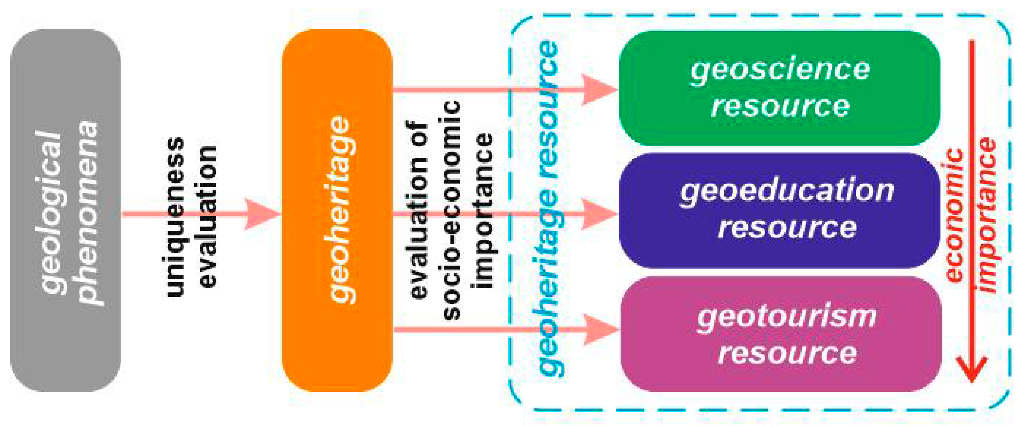
10]. Much attention has been paid to the identification of geo-heritage that is understood as a resource by definition. In fact, in order to recognize any natural element as a resource, its general societal utility should be argued. Geo-heritage has value to scientists needing appropriate objects for research, educators needing explanation of some basic knowledge to students and their training, and tourists interested in learning more about the nature. If so, three kinds of geo-heritage resources can be recognized, namely geoscience resources, geo-education resources, and geo-tourism resources (
Figure 1). From these, the latter are of special economic importance because geoparks and other geology-related attractions bring direct profit, as well as facilitating the entire tourism industry growth because of diversification of tourism products and services. The exploitation of the geo-heritage resource deepens people’s understanding of the natural environment’s complexity and fragility and, thus, contributes to the development of ecologically-responsible behavior. The creation of geo-parks diversifies leisure possibilities and offers new jobs.
The efficient exploitation of each natural resource requires accurate evaluation, particularly in finding properties that make the resource really valuable. Geo-tourism has grown actively since the 2000s [
1,
11,
12,
13,
14,
15,
16,
17]. This tendency has established together with the rise of the international and national geopark initiatives [
18,
19,
20]. In such conditions, new geo-tourist attractions seem to be in demand, and, thus, the principles of selection of geo-heritage objects for their creation need to be clarified. Evidently, the only high unique geological phenomena is not enough. The understanding of this uniqueness is often limited by the almost total absence of even elementary geological knowledge among the majority of visitors. Although this problem can be fixed with professional interpretations of the geological information (guided excursions, specially installed panels and kiosks, interactive and virtual tools, etc.) [
13,
21,
22,
23,
24,
25], the relevant solutions limit carrying capacity of geo-tourist attractions and require additional costs for geo-tourism resource exploitation. Moreover, tourists can be better satisfied from visits to geo-parks, offering easier-to-understand geo-heritage. If so, some unique geological features are more valuable than others, depending on how people without professional knowledge can perceive them. An indirect confirmation of this issue is the dominance of easy-to-understand geomorphological heritage (i.e., unique landforms) in the existing global geoparks [
8]. The importance of panoramic sites for geo-heritage observation argued by Migoń and Pijet-Migoń [
26] also implies an urgency of geo-heritage clarity and geology-dominated landscape admiration to tourists.
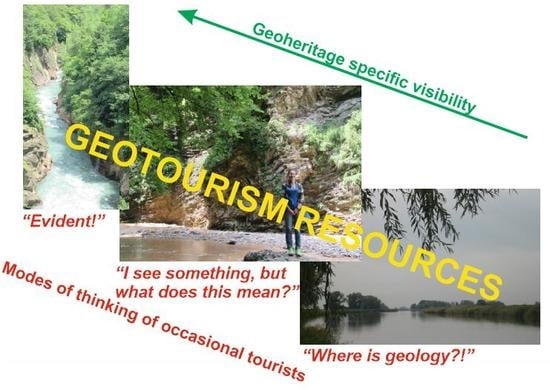
The main objective of the present paper is the introduction of geo-heritage-specific visibility as one of the key parameters in geo-tourism resource evaluation. It is intended to relate this parameter to different types of geo-heritage, as well as to demonstrate the differences in this parameter with some representative examples, that have been studied by the authors in two areas of southwest Russia.
2. Terminological and Methodological Notes
The visual appearance of geo-heritage is commonly thought to be a criterion of its evaluation [
27,
28]. Frequently, this criterion is understood with certain difference and limitations. For instance, Warowna et al. [
29] recognized the colour of geological features as the main aesthetic property, and Costantini and L’Abate [
30] proposed a distinction between visibility, exposure, and observability. Undoubtedly, a systematic treatment of the visual appearance of geo-heritage is necessary.
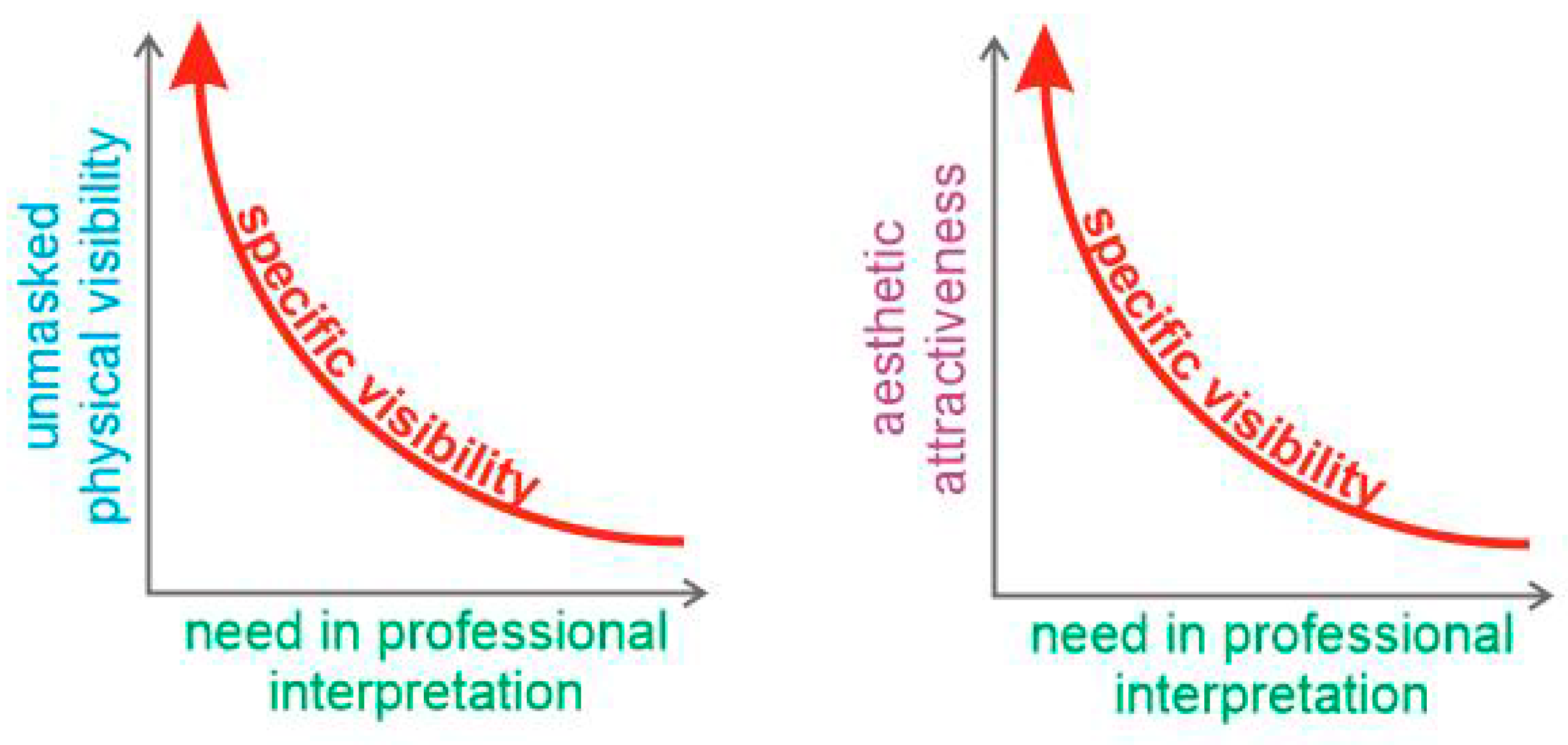
The perception of geo-heritage is a complex process that refers to three characteristics of the observable objects, namely unmasked physical visibility, a need in professional interpretation, and aesthetic attractiveness.
Physical visibility depends on whether tourists can observe a given geological object directly. This aspect is important because of the possibility to determine the very essence of each tourist attraction. For instance, bivalve shells can be observed in a palaeontological locality, whereas another locality distinguished by unusual geochemical processes does not permit these processes to be observed because of their appearance at the level of chemical compounds and the low speed. Clivaz and Reynard [
31] coined the term
invisible geomorphosites that describes unique landforms that do not longer exist, but remain interesting to visitors. It should be noted that vegetation or debris cover, location geometry, and infrastructure objects can prohibit adequate observation of a unique object. However, such situations are locality-dependent and should be ignored when the general category of geo-heritage is discussed. Thus, it is sensible to judge the
unmasked physical visibility, which means visibility of the geological phenomenon itself, irrespective of its manifestation in a given case. In other words, this term can be employed in geo-heritage-related judgments in the case of ideal exposure. A
Need in professional interpretation is a characteristic of geo-tourist attractions, reflecting its self-clarity. Tourist satisfaction strongly depends on whether she/he can easily understand the attraction or not [
13]. For instance, a waterfall will be detected as a waterfall by its visitors, whereas a globally-important stratotype representing boundary between two successive geological eras will not be understood as such without special explanation to the majority of visitors. Finally, the
aesthetic attractiveness of a unique phenomenon means the degree of its correspondence to the tourists’ idea of beauty. Undoubtedly, a beautiful tourist site makes a site more attractive (and this also makes tourist experience more enjoyable) [
13]. Although such an idea may differ significantly, there are some universal criteria for individual and group judgments of what is beautiful and what is not [
32,
33,
34].
Unmasked physical visibility, which is needed in professional interpretation and aesthetic attractiveness differ essentially, but these are also strongly related to one another, and these characteristics jointly determine the perception of geo-heritage by potential tourists. These characteristics make unique phenomena more or less visible to visitors. If so, it is sensible to introduce the integrative term, namely
specific visibility, which reflects how easily geo-heritage features can be seen by unprepared tourists (
Figure 2). The word
visibility is preferred over
clarity because the latter refers to the need for interpretation. Geo-heritage specific visibility seems to be one of the key parameters in geo-heritage resource evaluation. Its importance decreases in the case of geo-tourists with professional knowledge and ‘trained eyes’, i.e., those who do not depend on interpretation and knowing what, where, and how to see. However, the majority of geo-tourists remain unprepared (e.g., [
13]).
Specific visibility depends on many conditions and factors (often local—e.g., the presence of vegetation cover or slope debris, locality geometry, infrastructure, etc.), but it is sensible to understand whether unique geological phenomena (taken in ‘ideal’ state) differ in this parameter. If these differ, there is a differing importance of these phenomena as geo-tourism resources. Such a general knowledge would be very desirable at the stage of resource evaluation. For instance, this allos predictions to be made of visitor flow, anticipating costs for resource exploitation (e.g., for professional interpretation), and to judge which geological phenomena should be included in the planned geo-tourist attraction and to increase its value.
There are different classifications of unique geological phenomena (e.g., [
35,
36,
37,
38]). In this paper, the classification proposed by Ruban [
38] and refined by Habibi et al. [
5] is used (the other classifications can be further employed for the specific visibility analysis by the principle explained below).
Geo-heritage types reflect the main classes of all known geological phenomena, as representatives of these classes can be unique under certain circumstances. A total of 21 types are distinguished. The essence of each relevant class of geological phenomena is analyzed in order to conclude about common specific visibility. The approach is conceptual (real examples are not considered to avoid influence local specific features, although such examples are used for testing the results—see the Discussion section), as follows. A very typical feature, representing a given class, is considered (for instance, the igneous geo-heritage type would be best represented by an outcrop of granites). Then, it is judged on whether this feature is physically visible (if locally unmasked), whether it needs interpretation for unprepared visitors, and whether it matches some universal criteria of beauty. Importantly, the possible links between the three characteristics are traced where possible. For instance, the paleogeography type, which represents the information about the ancient environments and ecosystems, and these features existed in the only past and cannot be seen in the present-day rock outcrops (only indirect physical visibility); strong professional interpretation is necessary to realize these [
39]. The beauty is doubtful without such an interpretation. Such judgments resemble expert assessment, but these are based on objective (not subjective) criteria.
In order to trace the differences between the geo-heritage types by the analyzed parameter, the four categories of specific visibility are distinguished, namely high specific visibility (HSV; i.e., full visibility), moderate specific visibility (MSV; i.e., certain deficiencies in either unmasked physical visibility, or the need for professional interpretation, which can be recompensed partly by high aesthetic attractiveness), limited specific visibility (LSV; i.e., significant problems with seeing and/or understanding unique features), and specific invisibility (ISV; i.e., total invisibility, chiefly because of physical invisibility). For some types, specific visibility can vary depending on the relevant phenomena, and, thus, this variation is also taken into consideration.
3. Results
Geo-heritage types really differ in their specific visibility (
Table 1). Most common are the types characterized by MSV (41%). The types with HSV are also quite common (27%). ISV is established in 18% of cases. The least frequent are the types with LSV constituting only 14%. As specific visibility is thought to be an important determinant of geo-tourism resource value, the localities with palaeontological (fossils), mineralogical (minerals), geothermal (geysers), geomorphological (landforms), hydrological (geological activity of water), and geohistorical (sites of famous geological discoveries) should be identified as the most important for creation of geo-tourist attractions. These localities will be easily perceived by visitors and the costs for interpretation of infrastructure will be minimal. The examples of localities representing geo-heritage types with different specific visibility are given below (see Discussion).
The information on geoparks in seven countries boasting the biggest number of these tourist attractions implies that the most common geo-heritage types are geomorphological, paleontological, igneous, sedimentary, and palaeogeographical [
8]. These types represent the specific visibility categories, except for ISV (
Table 1). Supposing that the noted types comprise the most abundant geo-tourist attractions (not necessarily geoparks), it is possible to conclude that the available world geo-heritage demonstrates more or less significant specific visibility, i.e., it is a really valuable geo-tourism resource. However, a reversal interpretation is also sensible. It can be understood that, most probably, the geological features, with high or moderate specific visibility, are recognized more commonly than less-visible phenomena of the other types. In such a case, the entire world geo-heritage resource is limited because of the biased approaches of its recognition.
Interesting, four geo-heritage types are attributed to the ISV category. The geochemical and radio-geological types are characterized by the very small scale and chiefly long-term processes in the geological environment. Regular measurements and laboratory analyses are necessary to conclude these processes, and, thus, these cannot be seen directly in the field. Hydrogeological phenomena cannot be observed because these take place underground. The only natural springs and boreholes are manifestations of this type on the surface. Finally, the neotectonical type represents in slow motion the surface because of current tectonic activity. These motions can be detected only as a result of long-term measurements (e.g., with satellite-based remote sensing technologies) and highly-specific geological observations. These four types seem to be the least valuable in terms of geo-tourism resource or, rather, their exploitation for tourism will require significant investments in interpretation infrastructure and development of really advanced, innovative interpretation solutions. For instance, the demonstration of any peculiar geochemical process would require the installation of interactive panels or equipment for quick analyses of rocks, bottom deposits, and/or soils for the purpose of demonstrating the activities of this process. As for the palaeogeographical type, which may be thought invisible because of representation of ancient environments and ecosystems, it appears to be sensible to attribute it not to the ISV category, but to LSV. This is because particular elements and attributes of past environments and ecosystems are visible in rock outcrops. For instance, these may include in-situ preserved fossil assemblages, specific rock color indicating palaeoclimate.
Two other geo-heritage types deserve attention. The cosmogenic type is represented, either by meteorites stored in museum collections, which are well-visible, although cannot be recognized as meteorites without any simple explanation (MSV), or impact craters. The latter often can be established only as a result of the interpretation of geological, geomorphological, and geophysical information. In the other words, it is really difficult to distinguish these craters in the field by typical landforms or geological material (ISV). The structural type, which is constituted by folds, faults, nappe structures, etc., is physically visible in the field, but understanding their geological essence requires professional interpretation. Nonetheless, these geological phenomena are distinguished by significant aesthetic attractiveness [
33], which recompenses partly the noted unclarity. Additionally, viewpoint geo-sites (sensu Migoń and Pijet-Migoń [
26]) facilitate the perception of structural uniqueness together with enjoying observation of panoramic views.
4. Discussion
This paper proposes a new parameter, namely geo-heritage specific visibility and the principle of its evaluation. The outcomes of this principle application to geo-heritage types are presented above. However, the validity of such an approach should be discussed in regard to its testing in the real world. The idea of geo-heritage type results from conceptualization, and, thus, the notions of specific visibility of each type presented above have to be discussed with some examples. The authors’ field investigations in southwest Russia permit several real or potential geo-tourist attractions to be considered, five of which are located in the Western Caucasus (the geodiversity hotspot of Mountainous Adygeya [
38]), and two other are located near the Azov Sea in the Rostov Region [
40] (
Table 2). These localities provide examples of all four categories of specific visibility.
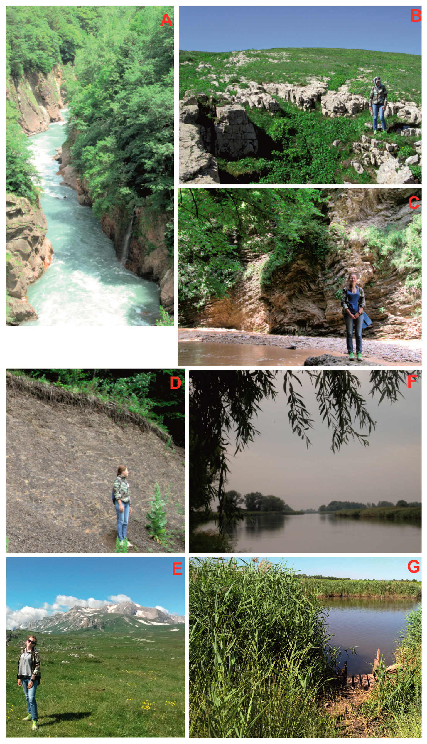
The Granite Gorge is a deep gorge cut by the Belaya River in the Late Paleozoic granites and granodiorites of the Dakh Crystalline Massif. This is a peculiar, nationally-unique landform (geomorphological type of geo-heritage). Visitors can observe typical morphology of the gorge from several viewpoints. The unmasked physical visibility of the gorge is excellent, there is not any need in professional interpretation, and the aesthetic attractiveness is evidently high (
Figure 3A). A road stretches along the gorge, and special places (‘pockets’) are constructed to leave a car and to enjoy panoramic views of the deep gorge. This locality can be attributed unequivocally to the HSV category, which is typical for the geomorphological type of geo-heritage (
Table 2). Consequently, the Granite Gorge is thought to be a valuable geo-tourism resource, and it is not surprising that it is crowded by visitors. This is one of very few, really successful geo-heritage-based tourist attractions of southwest Russia, which are visited by thousands of tourists coming from the both nearby towns and other regions of Russia.
The karst sinkhole in the Lagonaki Highland is a very typical epikarst feature formed as a result of carbonate rock dissolution on the area of significant rainfall. This is a locally-unique, small-scale landform (geomorphological type of geo-heritage). Visitors can walk around and observe it entirely (
Figure 3B). The unmasked physical visibility is excellent, but some explanation of the essence of such features is required in order to perceive it correctly. Aesthetic attractiveness is unimportant in this case because strong and positive impressions of tourists are formed from visiting the entire highland area. With regard to the above-said, this locality can be attributed to the MSV category. This is different from the most common category of specific visibility of the geomorphological type of geo-heritage, and, thus, this example demonstrates that the specific visibility can vary within the same type (
Table 2). This sinkhole seems to be a less valuable geo-tourism resource, and its inclusion in the programs of local excursions would require installation of the explanatory panel with a professional interpretation of the feature.
The folded Triassic rocks in the Rufabgo Canyon are exposed along the Rufabgo River (left tributary of the Belaya River), and these were formed because of orogenic compression or submarine slumping (or both). This structural feature is a part of a globally-unique geo-heritage. A popular excursion route stretches along natural outcrops with the folds. The unmasked physical visibility of the folds is perfect, but to understand their essence, without professional explanation, would be difficult for unprepared visitors; the aesthetic attractiveness is very significant because the folds look like natural geometry [
33] (
Figure 3C). Evidently, this locality has to be attributed to the MSV category, as well as the entire structural geo-heritage type (
Table 2). The folded Triassic rocks of the Rufabgo Canyon constitute significant geo-tourism resource, but its exploitation will require either funding professionally guided excursions or the installation of explanatory panels.
The palaeogeographical type can be demonstrated in two features, namely
the Jurassic deep-marine shales near the Partisan Glade, which represent the ancient deep sea with oxygen depleted-conditions, and
the Oshten Mountan, which is a Late Jurassic reefal massif (i.e., it was part of the ancient barrier reef). The former can be visited by tourists (
Figure 3D), and the latter is viewed from a distance of several kilometers for better comprehension (
Figure 3E). The unmasked physical visibility is exceptional in the both cases. However, it is very difficult to relate the currently-observable features to the ancient environments; a very advanced professional interpretation is necessary. The dark color of shales (a common result of oxygen deficit in the seawater) and the morphology of the mountain (fossil reef) would facilitate this interpretation slightly. The aesthetic attractiveness is much higher in the case of the Oshten Mountain, but it does not recompense the lack of clarity of the palaeogeographical essence in this site. These localities are sensible to attribute to the LSV category, which is typical for the palaeogeographical type of geo-heritage (
Table 2). Despite the evident geo-heritage value (especially in the case of the Oshten Mountain [
39]), the discussed features have very limited geo-tourism resource value. The exploitation of these resources will require additional costs to resolve the problem with professional interpretation. Most probably, these localities suit only excursions of professional geologists, students, and some geology amateurs.
The
Don River delta is a typical deltaic environment near the big city of Rostov-on-Don, representing interesting processes linked to mercury pollution, temporary storage, and removal by sea floods [
40], as well as various processes linked to contamination by other heavy metals, organic compounds, and oil-related matter. This is a nationally-unique geochemical feature, which can be visited by nature-oriented tourists. However, potential tourists cannot observe geochemical processes directly. They can see only water objects and rich ecosystems (
Figure 3F). Mercury cycling occurs in water, suspended matter, bottom sediments, and soils. This takes place at the level of chemical compounds, and its speed is slow. Sampling and laboratory analyses are necessary to realize the uniqueness of the geochemical phenomena. In the other words, the geo-heritage is totally invisible in this locality, and it should be attributed to the ISV category, which is characteristic to this type of geo-heritage (
Table 2). The geo-tourism resource value of the Don River delta is significantly restricted, and the exploitation of this resource would require costly and non-standard interpretation solutions.
The Pelenkino mud lake is tied genetically to the Don River delta. It represents the processes of sulfide mud formation. This is part of the local geo-heritage, and its main types are hydrological, sedimentary, and geochemical. Although visitors of this lake can observe the lake and mud itself (
Figure 3G), some professional interpretation is necessary to explain the essence of the mud; the geochemical processes that lead to mud formation are totally invisible. The HSV category should be attributed to the hydrological type, the MSV category should be attributed to the sedimentary type, and the ISV category should be attributed to the geochemical type. These categories are characteristic for the relevant types (
Table 2). In sum, this locality taken entirely is sensible to attribute to the MSV category. The geo-tourism resource value of the Pelenkino mud lake is somewhat restricted, and exploitation of this resource requires some professional support.
5. Conclusions
The undertaken study makes three main conclusions. First, geoheritage-specific visibility depends on physical visibility, the need for professional interpretation, and aesthetic attractiveness. These are important parameters in geotourism resource evaluation. Second, geoheritage types differ by specific visibility, which is important to consider when geotourism resources of any area or geopark are evaluated. Third, an analysis of real examples of geoheritage corroborates the usefulness of specific visibility as a geo-tourism resource parameter.
The parameter proposed in the present paper is treated as a tentative, qualitative manner. Broad consultations between theoreticians and practitioners in geotourism are necessary in order to strengthen the approach of its application. Undoubtedly, there may be some other parameters useful in geo-tourism resource evaluation, such as accessibility, the degree of vegetation/debris-masking, carrying capacity, etc. However, specific visibility seems to be a key parameter because it determines the possibility of the unique phenomena comprehension by visitors and, thus, their satisfaction from geo-tourist attractions. Moreover, the attention to specific visibility is necessary to improve strategies of geo-heritage promotion. Potentially, all kinds of geo-heritage can be interesting to the wide circle of people. If its visibility is considered properly, this emphasizes unique features that can attract visitor even with zero geological knowledge.


