Investigation of Landslides that Occurred in August on the Chengdu–Kunming Railway, Sichuan, China


Abstract
:1. Introduction
2. Investigation
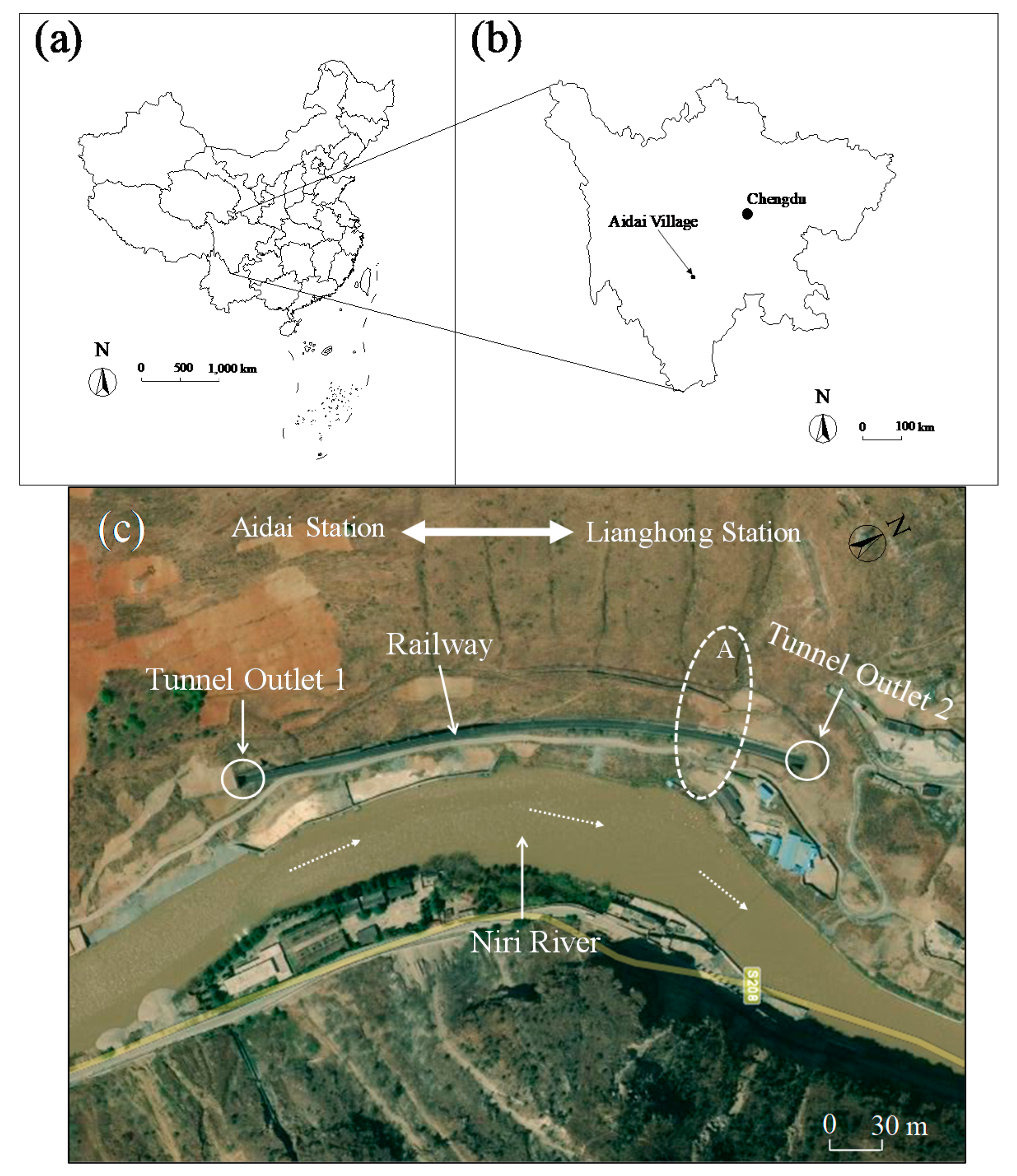
2.1. Data Source
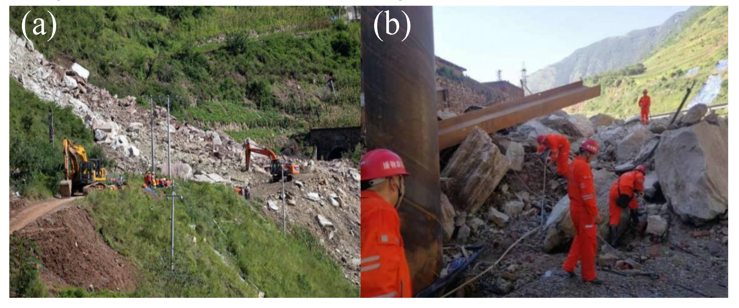
2.2. Rescue Effort
3. Analysis and Discussion
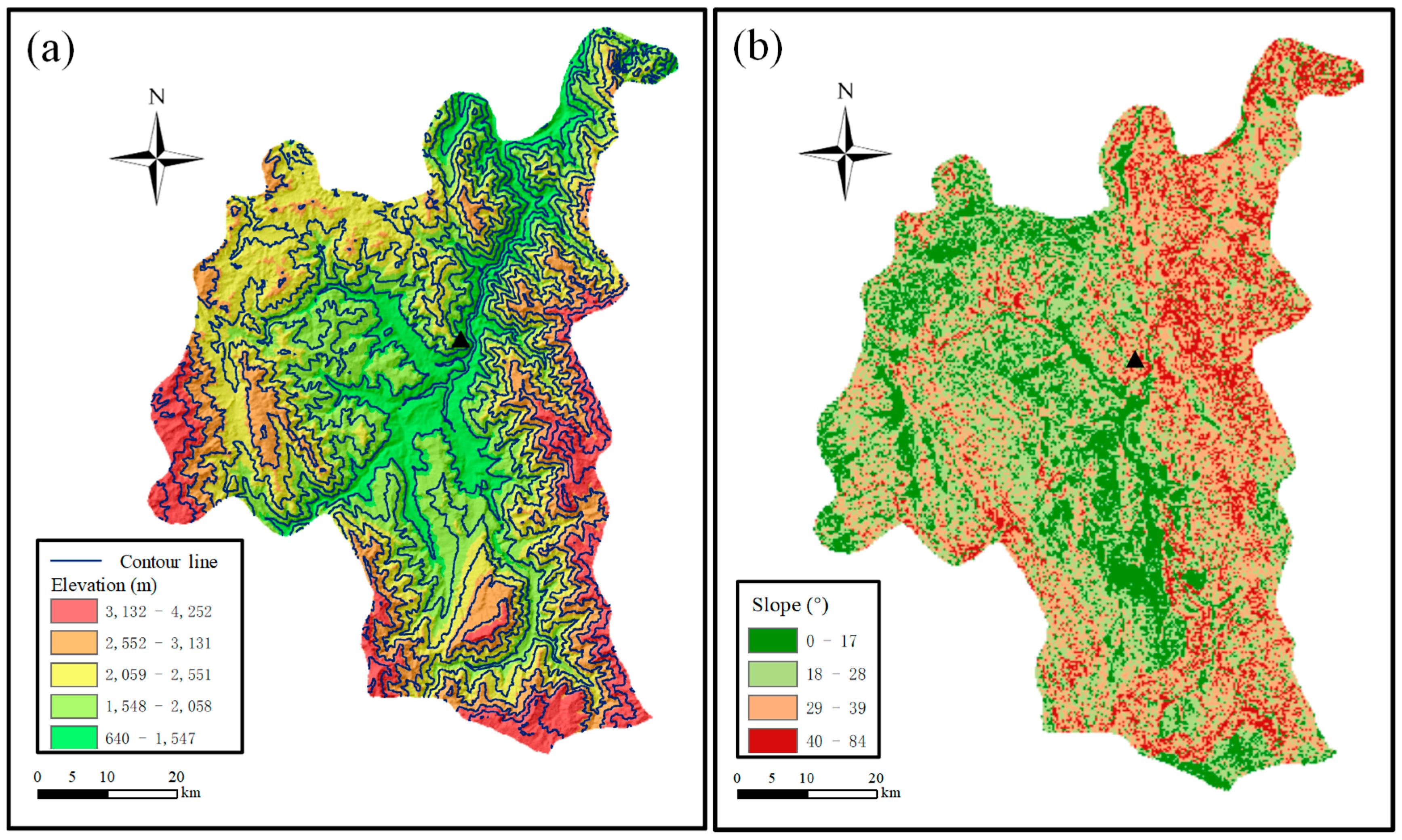
3.1. Internal Factors: Geographical Position, Geological Conditions and Seismic Fracture Zone
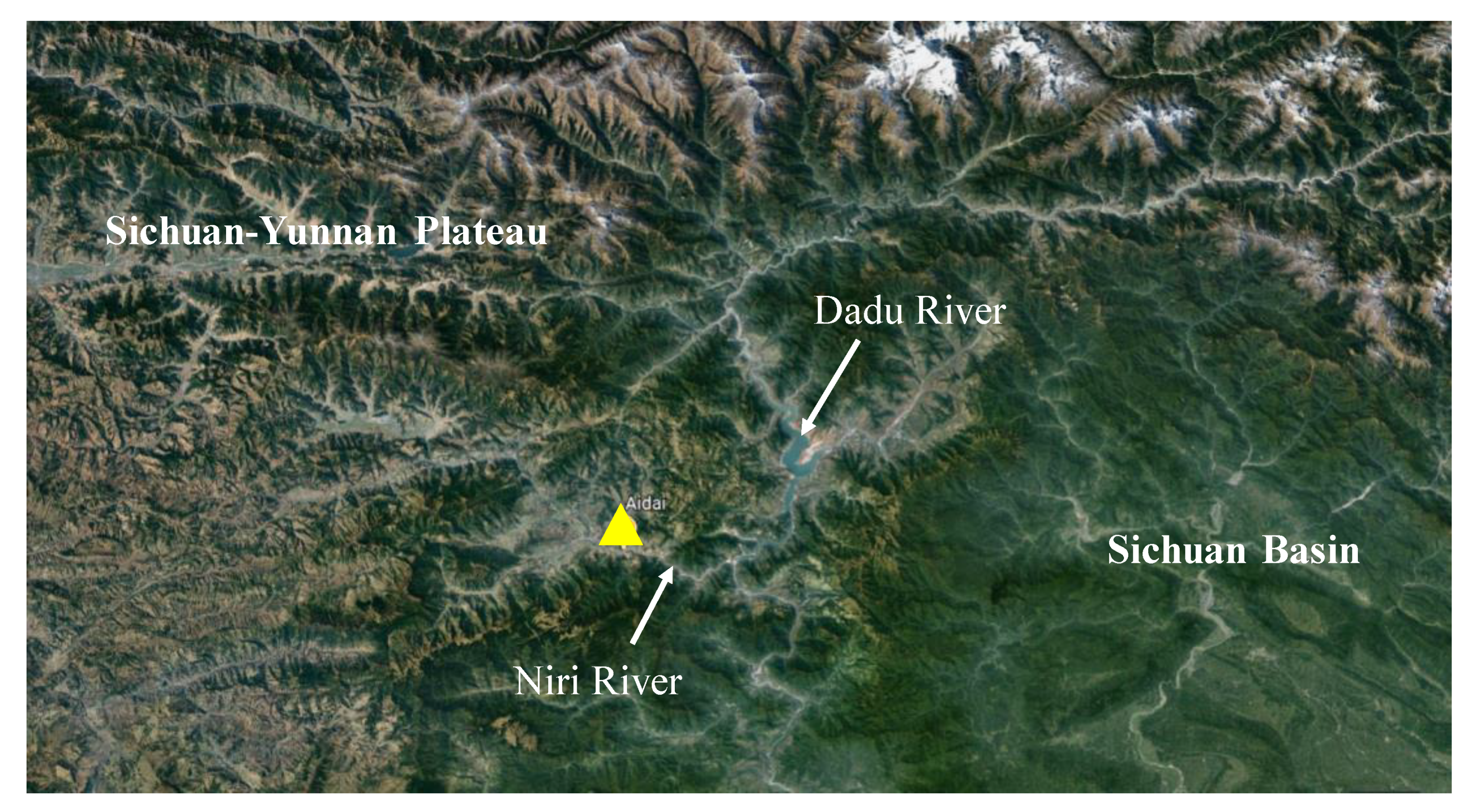
3.1.1. Geographical Position and Geological Conditions
3.1.2. Seismic Fracture Zone
3.2. External Factors: Rainfall, Track Vibration and Flood Erosion
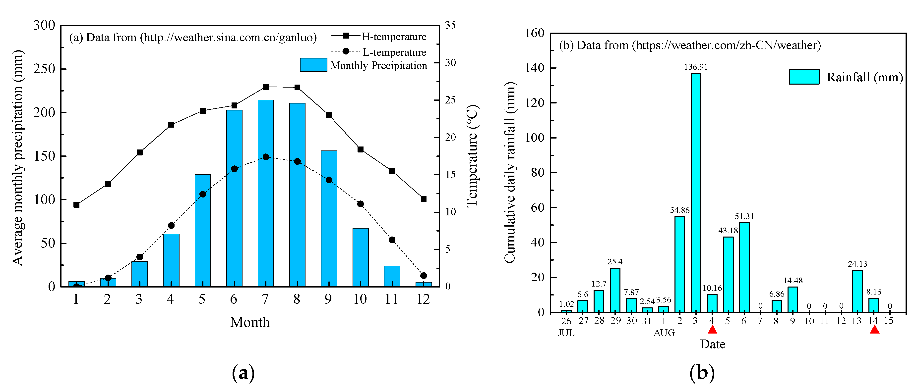
3.2.1. Rainfall
3.2.2. Flood Erosion
3.2.3. Human Activity
3.3. Recommendations
- Risk assessment should be conducted to reveal the risk level along the Chengdu–Kunming railway. There are many quantitative or statistical risk assessment methods able to predict landslide susceptibility, e.g., logistic regression (LR) [35], analytical hierarchy process (AHP) [36,37,38,39,40,41], and frequency ratio (FR). The landslide susceptibility can also be mapped using geographic information system (GIS) technology [36,37,38,39,40,41,42,43,44]. Based on a comparative study, Yalcin [45] concluded that the AHP method yielded a more realistic scenario regarding the actual distribution of landslide susceptibility. The application of these models can give guidance for monitoring the occurrence of a landslide.
- Therefore, the application of remote sensing (RS) and GIS for landslide disaster management is necessary [15]. For instance, two consecutive landslides within a month starting on 11 October 2018 and twice blocked the Jinsha River which is the upper reaches of the Yangtze River at the junction of Sichuan Province and Tibet in China [46]. However, with the deployment of a real-time landslide early warning system, local authorities took immediate action to quickly and safely construct spillways to drain the dammed lake. It avoided the most serious cases, where loss of life and property is at least one order of magnitude lower than that observed without rapid intervention. Because the western region of Sichuan is the transition zone of the Sichuan Basin and Yun-Gui Plateau and the geological characteristics of these two regions are similar, the railway and its related departments can follow this model for further research and development of monitoring. The government may be able to obtain all the data from the time-lapse to the end of a landslide by monitoring areas where landslides occur on a long-term basis such as the example above. In addition, drones can also periodically measure the topography of the landslide’s starting area, combined with GIS technology to analyse the time variation of the storage space distribution in the landslide’s starting area [36,38,47].
- In Ganluo County, Sichuan Province, the summer rainfall is rich, and the groundwater is abundant [31]. Most landslides are triggered by rainfall, with the influence of the monsoon climate and environmental changes. The hydro-meteorological data also show that two series of early precipitation for 10 days may produce excess pore water pressure and high saturation in landslide and debris flow areas [48]. Therefore, the data using the rainfall assimilation method provides a new method for merging multisource data with models, which may be used to predict the displacement of landslides [49]. In addition, the landslide simultaneous state and parameter estimation strategy were able to make use of time-series displacements and hydrological information for the joint estimation of landslide displacement and model parameters. It was able to improve the performance considerably. The establishment of a groundwater flow model may be effective for better planning and location of landslide stability enhancement measures [50]. In addition to the methods mentioned above, relatively low-cost countermeasure could be employed to define rainfall thresholds that have been used as a base for an EWS in Emilia Romagna (Italy). Experiences show that only a few data are needed if a long-term research project is established, but the performance can improve greatly with time [51].
- The deaths and missing persons at the landslide site were station staff and workers who were clearing the railway drains. Therefore, in such a remote area, if the geological survey and landslide warning after the landslide occur, similar casualties could be avoided. In particular, after the first mudslide (19 July) and landslide (4 August), measures such as reinforcement, blasting, or removal of the surrounding loose soil should be taken quickly.
4. Concluding Remarks
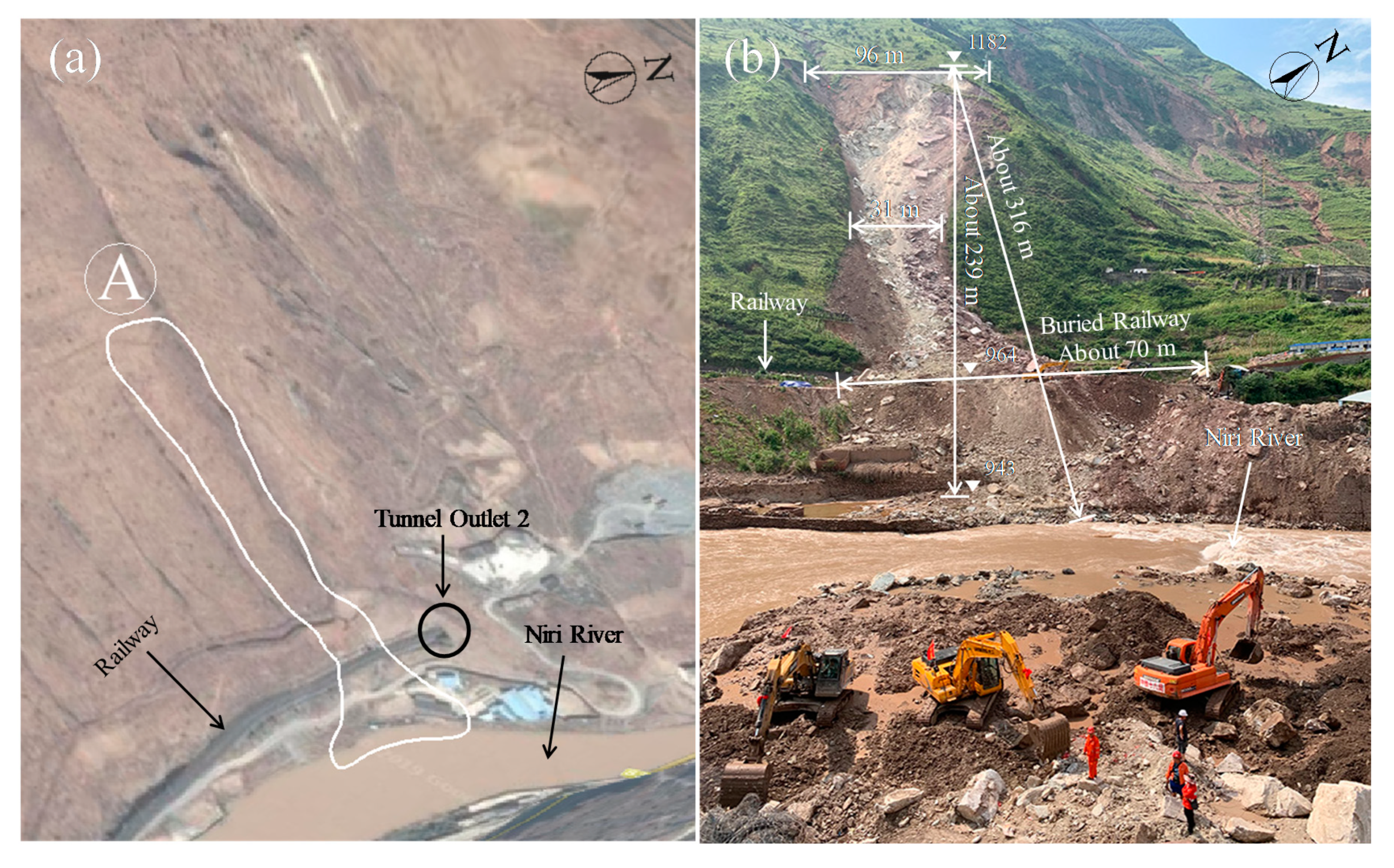
- A moderate size landslide event, with about 48000 m3 of earth and rocks, occurred at Ganluo, resulting in 12 fatalities and five people reported as missing, destroying a section of the railway of approximately 70 m and causing this section of the train service to be suspended for 15 days.
- The reason that caused the landslides were due to the combined effects of frequent former earthquakes, steep topography, large amounts of rainfall water, deep-seated sliding interface, dynamic train running load, and the effects of the previous two geological disasters, etc. These effects led to severe casualties and environmental impacts. For prevention and mitigation of these slide hazards, risk assessment concerning landslides should be conducted first to reveal the risk level along the Chengdu–Kunming railway line. Based on the risk assessment results, early warning systems should be provided through cost-effective precipitation and groundwater sensing technologies as well as the establishment of GIS databases to continuously monitor geologically risk-prone areas.
- After the landslide disaster, continuous monitoring of the surrounding soil in a timely manner should be conducted to deploy and evacuate relevant rescue workers. Disaster prevention education for villagers living in vulnerable areas is also important. This will reduce casualties in similar incidents in the future.
Author Contributions
Funding
Acknowledgments
Conflicts of Interest
References
- Petley, D. Global patterns of loss of life from landslides. Geology 2012, 40, 927–930. [Google Scholar] [CrossRef]
- Battistini, A.; Segoni, S.; Manzo, G.; Catani, F.; Casagli, N. Web data mining for automatic inventory of geohazards at national scale. Appl. Geogr. 2013, 43, 147–158. [Google Scholar] [CrossRef]
- Dowling, C.A.; Santi, P.M. Debris flows and their toll on human life: A global analysis of debris-flow fatalities from 1950 to 2011. Nat. Hazards 2014, 71, 203–227. [Google Scholar] [CrossRef]
- Ministry of Emergency Management, PRC (MEMPRC). Basic Situation of Natural Hazards of China in 2018, MEMPRC. Available online: http://www.mem.gov.cn/xw/zhsgxx/201901/t20190108_242580.shtml (accessed on 9 January 2019). (In Chinese)
- Wang, G.X. Key technique in landslide control and its handling measures. Chin. J. Rock Mech. Eng. 2005, 24, 3818. (In Chinese) [Google Scholar] [CrossRef]
- Dai, F.C.; Lee, C.F.; Ngai, Y.Y. Landslide risk assessment and management: An overview. Eng. Geol. 2002, 64, 65–87. [Google Scholar] [CrossRef]
- Hu, X.; Hu, K.; Tang, J.; You, Y.; Wu, C. Assessment of debris-flow potential dangers in the Jiuzhaigou Valley following the August 8, 2017, Jiuzhaigou earthquake, western China. Eng. Geol. 2019, 256, 57–66. [Google Scholar] [CrossRef]
- Wang, L.; Yin, Y.; Huang, B.; Zhang, Z.; Wei, Y. Formation and characteristics of Guang’an Village landslide in Wuxi, Chongqing, China. Landslides 2019, 16, 127–138. [Google Scholar] [CrossRef]
- Meng, W.; Xu, Y.; Cheng, W.C.; Arulrajah, A. Landslide event on 24 June in Sichuan Province, China: Preliminary investigation and analysis. Geosciences 2018, 8, 39. [Google Scholar] [CrossRef]
- Piciullo, L.; Calvello, M.; Cepeda, J.M. Territorial early warning systems for rainfall-induced landslides. Earth Sci. Rev. 2018, 179, 228–247. [Google Scholar] [CrossRef]
- Chae, B.G.; Park, H.J.; Catani, F.; Simoni, A.; Berti, M. Landslide prediction, monitoring and early warning: A concise review of state-of-the-art. Geosci. J. 2017, 21, 1033–1070. [Google Scholar] [CrossRef]
- Baum, R.L.; Godt, J.W. Erratum to: Early warning of rainfall-induced shallow landslides and debris flows in the USA. Landslides 2010, 7, 387. [Google Scholar] [CrossRef]
- Graziella, D.; Ingeborg, K.; Monica, S.; Nils-Kristian, O.; Ragnar, E.; Erik, J.; Hervé, C. Landslide early warning system and web tools for real-time scenarios and for distribution of warning messages in Norway. In Engineering Geology for Society and Territory; Springer: Cham, Switzerland, 2015; Volume 2, pp. 625–629. [Google Scholar] [CrossRef]
- Kim, D.; Lee, C.; Woo, C.; Seo, J.; Kang, M.; Kwon, H. The pilot construction of a sensor-based landslide early warning system for mitigating human damages, Republic of Korea. In Proceedings of the Workshop on World Landslide Forum, Ljubljana, Slovenia, 29 May–2 June 2017; Springer: Cham, Switzerland, 2017; pp. 139–145. [Google Scholar] [CrossRef]
- Ayele, S.; Raghuvanshi, T.K.; Kala, P.M. Application of Remote Sensing and GIS for Landslide Disaster Management: A Case from Abay Gorge, Gohatsion–Dejen Section, Ethiopia. In Landscape Ecology and Water Management; Springer: Tokyo, Japan, 2014; pp. 15–32. [Google Scholar] [CrossRef]
- Southern Metropolis Daily. Straight into the Cheng-Kun Railway Mountain Collapse Moment: No Warning Suddenly Loud Bang, Sand Blocks Hit Four or Five People Flying. Available online: http://ishare.ifeng.com/c/s/7pFZ1eWNWhb (accessed on 19 August 2019). (In Chinese).
- Xinhua News Agency New Media. Satellite Images Tell You Why the Chengkun Railway has been Disrupted Several Times Recently. Available online: https://baijiahao.baidu.com/s?id=1642026512324615782&wfr=spider&for=pc (accessed on 16 August 2019). (In Chinese).
- People’s Network Sichuan Channel. Emergency Rescue of Armed Police Officers and Soldiers for Landslides Caused by Heavy Rainfall in Ganluo, Sichuan. Available online: http://k.sina.com.cn/article_2086029453_p7c56488d027015xxj.html?from=news&subch=photo) (accessed on 15 August 2019). (In Chinese).
- Sina News. The Instant of Life and Death on Chengdu-Kunming line: Stone Ran after Him and was Buried One or Two Seconds Later. Available online: https://news.sina.com.cn/c/2019-08-19/doc-ihytcitn0163880.shtml (accessed on 19 August 2019). (In Chinese).
- China High-Resolution Observation. Sichuan Center of High Score Observation Fully Supports Disaster Emergency Rescue Work in Ganluo County and Wenchuan County. Available online: https://mp.weixin.qq.com/s/Gken4y6yr5WutJFWpmDUMA (accessed on 22 August 2019). (In Chinese).
- Beijing-Tianjin Network. Chengdu-Kunming Railway Rescue Progress: Four Suspected Bodies Are Being Recovered and the Identities Are Being Verified. Available online: https://baijiahao.baidu.com/s?id=1642166585279450425&wfr=spider&for=pc (accessed on 18 August 2019). (In Chinese).
- Southern Metropolitan Daily. Chengdu-Kunming Railway Mountain Collapse Site Found 4 Suspected Missing Bodies! Identification Is Being Verified. Available online: http://ishare.ifeng.com/c/s/7pDcVeekE0G (accessed on 17 August 2019). (In Chinese).
- Sun, X.F.; Bai, Z.Y.; Li, D.L. Control Action of Geological Structure on Development Law of Debris Flow at Ebian-Dechang Section of Chengdu-Kunming Railway. Subgrade Eng. 2012, 4, 57. (In Chinese) [Google Scholar] [CrossRef]
- Liu, Y.L.; Wu, J.; Tang, Y.; Yang, G.; Zhu, L. An investigation of heavy-metal concentration in dominant plant species in a zinc-lead mining area in Ganluo County of Sichuan Province. Acta Ecol. Sin. 2009, 29, 2020–2026. (In Chinese) [Google Scholar] [CrossRef]
- Liu, Y.S.; He, Z.-W.; Wu, D.-C.; Xiao, Y.-F.; Zhou, R.-B. Geomorphic Features of the Jinchuan-Badi Sector of the Dadu River Valley. Acta Geol. Sichuan 2007, 27, 162–165. (In Chinese) [Google Scholar] [CrossRef]
- Tang, R.; Fan, X.; Scaringi, G.; Xu, Q.; van Westen, C.J.; Ren, J.; Havenith, H.B. Distinctive controls on the distribution of river-damming and non-damming landslides induced by the 2008 Wenchuan earthquake. Bull. Eng. Geol. Environ. 2019, 78, 4075–4093. [Google Scholar] [CrossRef]
- Wang, G.; Zhang, M.; Peng, J.; Zhu, H. Landslides triggered by the Ms 7.0 earthquake of 20 April 2013 in Lushan, SW China. In Landslide Science for a Safer Geoenvironment; Springer: Cham, Switzerland, 2014; pp. 141–148. [Google Scholar] [CrossRef]
- Lou, H.; Wang, C.Y. Wavelet analysis and interpretation of gravity data in Sichuan-Yunnan region, China. Acta Seismol. Sin. 2005, 18, 552–561. [Google Scholar] [CrossRef]
- Fan, X.; Xu, Q.; Scaringi, G. Brief communication: Post-seismic landslides, the tough lesson of a catastrophe. Nat. Hazards Earth System Sci. 2018, 18, 397–403. [Google Scholar] [CrossRef]
- Fan, X.; Scaringi, G.; Korup, O.; West, J.A.; Westen, C.J.V.; Tanyas, H.; Hovius, N.; Hales, T.C.; Jibson, R.W.; Allstadt, K.E.; et al. Earthquake-Induced Chains of Geologic Hazards: Patterns, Mechanisms, and Impacts. Rev. Geophys. 2019, 57, 421–503. [Google Scholar] [CrossRef]
- Fan, X.; Xu, Q.; Scaringi, G.; Dai, L.X.; Li, W.L.; Dong, X.J.; Zhu, X.; Pei, X.J.; Dai, K.R.; Havenith, H.B. Failure mechanism and kinematics of the deadly June 24th 2017 Xinmo landslide, Maoxian, Sichuan, China. Landslides 2017, 14, 2129–2146. [Google Scholar] [CrossRef]
- Fan, X.; Xu, Q.; Scaringi, G.; Zheng, G.; Huang, R.; Dai, L.; Ju, Y. The “long” runout rock avalanche in Pusa, China, on August 28, 2017: A preliminary report. Landslides 2019, 16, 139–154. [Google Scholar] [CrossRef]
- China Weather News. Ganluo County Introduction. Available online: www.weather.com.cn/cityintro/101271616.shtml (accessed on 25 November 2019). (In Chinese).
- Sina News. Rain Storms Hitting Liangshan Ganluo County, Affecting 15,000 People, Leaving Seven Missing. Available online: https://news.sina.com.cn/o/2019-07-30/doc-ihytcerm7386644.shtml (accessed on 30 July 2019). (In Chinese).
- Shahabi, H.; Khezri, S.; Ahmad, B.B.; Hashim, M. Landslide susceptibility mapping at central Zabbasin, Iran: A comparison between analytical hierarchy process, frequency ratio and logistic regression models. Catena 2014, 115, 55–70. [Google Scholar] [CrossRef]
- Lyu, H.M.; Shen, S.L.; Zhou, A.N.; Yang, J. Risk assessment of mega-city infrastructures related to land subsidence using improved trapezoidal FAHP. Sci. Total Environ. 2019. [Google Scholar] [CrossRef]
- Lyu, H.M.; Wang, G.F.; Cheng, W.C.; Shen, S.L. Tornado hazards on June 23rd in Jiangsu Province, China: Preliminary investigation and analysis. Nat. Hazards 2017, 85, 597–604. [Google Scholar] [CrossRef]
- Lyu, H.M.; Shen, S.L.; Yang, J.; Yin, Z.Y. Inundation analysis of metro systems with the storm water management model incorporated into a geographical information system: A case study in Shanghai. Hydrol. Earth Syst. Sci. 2019, 23, 4293–4307. [Google Scholar] [CrossRef]
- Lyu, H.M.; Sun, W.J.; Shen, S.L.; Zhou, A.N. Risk assessment using a new consulting process in fuzzy AHP. J. Constr. Eng. Manag. 2019. [Google Scholar] [CrossRef]
- Lyu, H.M.; Shen, S.L.; Zhou, A.N.; Zhou, W.H. Flood risk assessment of metro systems in a subsiding environment using the interval FAHP-FCA approach. Sustain. Cities Soc. 2019, 50, 101682. [Google Scholar] [CrossRef]
- Lyu, H.M.; Shen, S.L.; Zhou, A.N.; Yang, J. Perspectives for flood risk assessment and management for mega-city metro system. Tunn. Undergr. Space Technol. 2019, 84, 31–44. [Google Scholar] [CrossRef]
- Peng, J.; Peng, F.L. A GIS-Based evaluation method of underground space resource for urban spatial planning: Part 1 Methodology. Tunn. Undergr. Space Technol. 2018, 74, 82–95. [Google Scholar] [CrossRef]
- Qiao, Y.K.; Peng, F.L.; Wang, Y. Monetary valuation of urban underground space: A critical issue for the decision-making of urban underground space development. Land Use Policy 2017, 69, 12–24. [Google Scholar] [CrossRef]
- Qiao, Y.K.; Peng, F.L.; Sabri, S.; Rajabifard, A. Low carbon effects of urban underground space. Sustain. Cities Soc. 2019, 45, 451–459. [Google Scholar] [CrossRef]
- Yalcin, A. GIS-based landslide susceptibility mapping using analytical hierarchy process and bivariate statistics in Ardesen (Turkey): Comparisons of results and confirmations. Catena 2008, 72, 1–12. [Google Scholar] [CrossRef]
- Fan, X.; Xu, Q.; Alonso-Rodriguez, A.; Subramanian, S.S.; Li, W.; Zheng, G.; Dong, X.J.; Huang, R.Q. Successive landsliding and damming of the Jinsha River in eastern Tibet, China: Prime investigation, early warning, and emergency response. Landslides 2019, 16, 1003–1020. [Google Scholar] [CrossRef]
- Imaizumi, F.; Masui, T.; Yokota, Y.; Tsunetaka, H.; Hayakawa, Y.S.; Hotta, N. Initiation and runout characteristics of debris flow surges in Ohya landslide scar, Japan. Geomorphology 2019, 339, 58–69. [Google Scholar] [CrossRef]
- Setiawan, H.; Wilopo, W.; Wiyoso, T.; Fathani, T.F.; Karnawati, D. Investigation and numerical simulation of the 22 February 2018 landslide-triggered long-traveling debris flow at Pasir Panjang Village, Brebes Regency of Central Java, Indonesia. Landslides 2019, 1–14. [Google Scholar] [CrossRef]
- Wang, J.; Nie, G.; Gao, S.; Xue, C. Simultaneous state–parameter estimation of rainfall-induced landslide displacement using data assimilation. Nat. Hazards Earth Syst. Sci. 2019, 19. [Google Scholar] [CrossRef]
- Shrestha, H.K.; Yatabe, R.; Bhandary, N.P. Groundwater flow modeling for effective implementation of landslide stability enhancement measures. Landslides 2008, 5, 281–290. [Google Scholar] [CrossRef]
- Segoni, S.; Rosi, A.; Fanti, R.; Gallucci, A.; Monni, A.; Casagli, N. A Regional-Scale Landslide Warning System Based on 20 Years of Operational Experience. Water 2018, 10, 1297. [Google Scholar] [CrossRef] [Green Version]

© 2019 by the authors. Licensee MDPI, Basel, Switzerland. This article is an open access article distributed under the terms and conditions of the Creative Commons Attribution (CC BY) license (http://creativecommons.org/licenses/by/4.0/).
Share and Cite
Zheng, Q.; Shen, S.-L.; Zhou, A.-N.; Cai, H. Investigation of Landslides that Occurred in August on the Chengdu–Kunming Railway, Sichuan, China. Geosciences 2019, 9, 497. https://doi.org/10.3390/geosciences9120497
Zheng Q, Shen S-L, Zhou A-N, Cai H. Investigation of Landslides that Occurred in August on the Chengdu–Kunming Railway, Sichuan, China. Geosciences. 2019; 9(12):497. https://doi.org/10.3390/geosciences9120497
Chicago/Turabian StyleZheng, Qian, Shui-Long Shen, An-Nan Zhou, and Hao Cai. 2019. "Investigation of Landslides that Occurred in August on the Chengdu–Kunming Railway, Sichuan, China" Geosciences 9, no. 12: 497. https://doi.org/10.3390/geosciences9120497
APA StyleZheng, Q., Shen, S.-L., Zhou, A.-N., & Cai, H. (2019). Investigation of Landslides that Occurred in August on the Chengdu–Kunming Railway, Sichuan, China. Geosciences, 9(12), 497. https://doi.org/10.3390/geosciences9120497