Article

On-Site Water and Wind Erosion Experiments Reveal Relative Impact on Total Soil Erosion

1
Physical Geography, Trier University, 54286 Trier, Germany
2
Physical Geography and Environmental Change, University of Basel, 4056 Basel, Switzerland
3
Soil Erosion and Degradation Research Group, Department of Geography, University of Valencia, 46010 Valencia, Spain
*
Author to whom correspondence should be addressed.
Geosciences 2019, 9(11), 478; https://doi.org/10.3390/geosciences9110478
Submission received: 23 August 2019 / Revised: 24 October 2019 / Accepted: 10 November 2019 / Published: 14 November 2019

Abstract

:
The relative impact of water and wind on total erosion was investigated by means of an experimental-empirical study. Wind erosion and water erosion were measured at five different sites: (1) Mediterranean fallow, (2) Mediterranean orchard, (3) wheat field, (4) vineyard and (5) sand substrate. Mean erosion rates ranged from 1.55 to 618 g·m−2·h−1 for wind and from 0.09 to 133.90 g·m−2·h−1 for rain eroded material over all tested sites. Percentages (%) of eroded sediment for wind and rain, respectively, were found to be 2:98 on Mediterranean fallow, 11:89 on Mediterranean orchard, 3:97 on wheat field, 98:2 on vineyard and 99:1 on sand substrate. For the special case of soil surface crust destroyed by goat trampling, the measured values emphasize a strong potential impact of herding on total soil erosion. All sites produced erosion by wind and rain, and relations show that both erosive forces may have an impact on total soil erosion depending on site characteristics. The results indicate a strong need to focus on both wind and water erosion particularly concerning soils and substrates in vulnerable environments. Measured rates show a general potential erosion depending on recent developments of land use and climate change and may raise awareness of scientist, farmers and decision makers about potential impact of both erosive forces. Knowledge about exact relationship is key for an adapted land use management, which has great potential to mitigate degradation processes related to climate change.

1. Introduction

Risk assessment and prediction of hydrological and anemological impact on soil erosion rates are great challenges to scientists, politicians and food producers alike and are among the most urgent tasks in the early 21st century [1,2]. Among the effects are ecological consequences such as reduced soil depth, including unfavorable conditions for soil organisms and pollution of associated surface waters with sediments, as well as socio-economic implications such reduced soil productivity, contaminated drinking water and direct health risks associated to dust production [3,4].
The major erosive forces are water and wind. In most environments, both wind and rain are active climatological factors and could be expected to be potential contributors to total soil loss, but most studies focus on one factor exclusively.
Extent and share of each erosive force depend on many variables on different spatio-temporal scales [5,6]. For both types of erosion, risk maps for different scales are available, which estimate potential soil loss for the given region based on general approximate information concerning soil and surface properties combined with climatological data [7,8,9,10]. These maps are helpful for science communication, highlighting general parameters, regional specifications and interrelations associated to the soil erosion complex. They should, however, not completely define research attempts and study designs, particularly in the light of profound mid-term-changes of climate and demands in land use.
The processes of wind and water erosion are similar concerning the general structure of detachment, transport and accumulation [11]. Both types of erosion encompass several tempo-spatial scales and a variability that have been immensely complicating a comprehensive evaluation. The destructive potential of extreme wind events is counted among the most devastating natural hazards [12,13]. Caused by climate change, wind storms of higher intensity may become a new hazard to several regions in the medium term either due to higher wind energy [14] or extended residence time [15]. Following the IPCC 2014 (AR5) [16], tempo-spatial development of wind energy and heavy storm events are a factor of high uncertainty, but relative impact of high extreme wind events on total global wind erosion has not been evaluated yet. Wind erosion is not necessarily attributed to extreme events but may be triggered by low to medium wind velocities. Chepil and Woodruff [17] found 4.5 m·s−1 at 0.3 m height (6 m·s−1 at 10 m height) sufficient to move particles of 0.1 mm diameter under dry and smooth conditions. Wind velocities in this range can be considered very common conditions in many regions of the world during considerable parts of the year [18].
Still, the amount and tempo-spatial extent are highly speculative and quantitative data are rare. While traces of soil erosion by water are often evident in the field even at smaller extent, Chepil [19] estimated that soil of up to 40 t ha–1 can be eroded per year unnoticed. This is particularly problematic due to the sorting action of wind, which mainly affects the finest particles silt and clay as well as soil organic matter and soil nutrients such as phosphorus [20]. For Middle Europe, Funk et al. [12] estimated 20% of arable land is threatened by wind erosion and Buschiazzo et al. [21] state that spatial extent of wind erosion has increased in the past decades. In the recent IPCC Special Report (SRCCL), Pӧrtner et al. [22] define land use and land use change as a major trigger for global soil erosion and land degradation and indicates that appropriate land use is crucial to mitigate climate change effects. The extent of wind erosion and related processes is particularly mentioned as a growing threat to agricultural soils [22].
In contrast, water erosion has long been recognized as the main factor generating soil erosion globally and in most European environments [23], and focused as a main threat for ecological and socio-economic stability [24,25]. This may also be caused by the fact that water erosion-related processes generate easily recognizable forms such as rills, gullies and alluvial fans of different sizes. Besides each erosion agent’s specific effects on soil erosion rates and land degradation, Ravi et al. point out possible interactions between both processes over time and space [26]—which is especially true for arid and semi-arid areas [27].
To focus on processes and amounts on small scale and with high accuracy, on-site measurements by means of the Trier Portable Wind and Rainfall Simulator (PWRS) were conducted. The degree of impact of wind and rain on soil erosion is determined by soil surface properties related resilience to particle detachment, which is a consequence from effects and interactions between surface characteristics such as roughness, slope, aggregate stability and stone/vegetation/seal-cover [24]. The spatial variability of wind erosion is particularly strong and depends on partly slight variations of the surface [28]. Since experimental studies are mostly conducted by means of disturbed soil samples, a comprehensive assessment of soil surface response is still very difficult to obtain. A particular advantage of the experimental setup presented here is the possibility to study soils and substrates in situ. Elaborate studies highlight physical parameters of single aspects of transport processes by wind [29,30,31], runoff [32,33,34,35], windless raindrops [36,37] and wind-driven rain [38,39,40] under homogeneous, simplified substrate conditions or modelling approaches. Experimental in situ studies on soil and substrate surfaces under largely undisturbed conditions are often the only source of information about natural substrate response and are therefore of great importance to complement findings from laboratory setups and increase process understanding.
The main objectives for the empirical-experimental study are to test different soils and substrates for their specific response in terms of soil erosion by wind and water to deepen the process understanding beyond traditional views, and to calculate site-specific relative impact of each erosion agent, which can be calculated to approach key parameters corresponding to soil or substrate surface, management and climate.
We hypothesize that:
  • All tested soil surfaces produce soil erosion due to the action of wind and rain.
  • The relative impact of soil erosion agent differs corresponding to site characteristics.

2. Materials and Methods

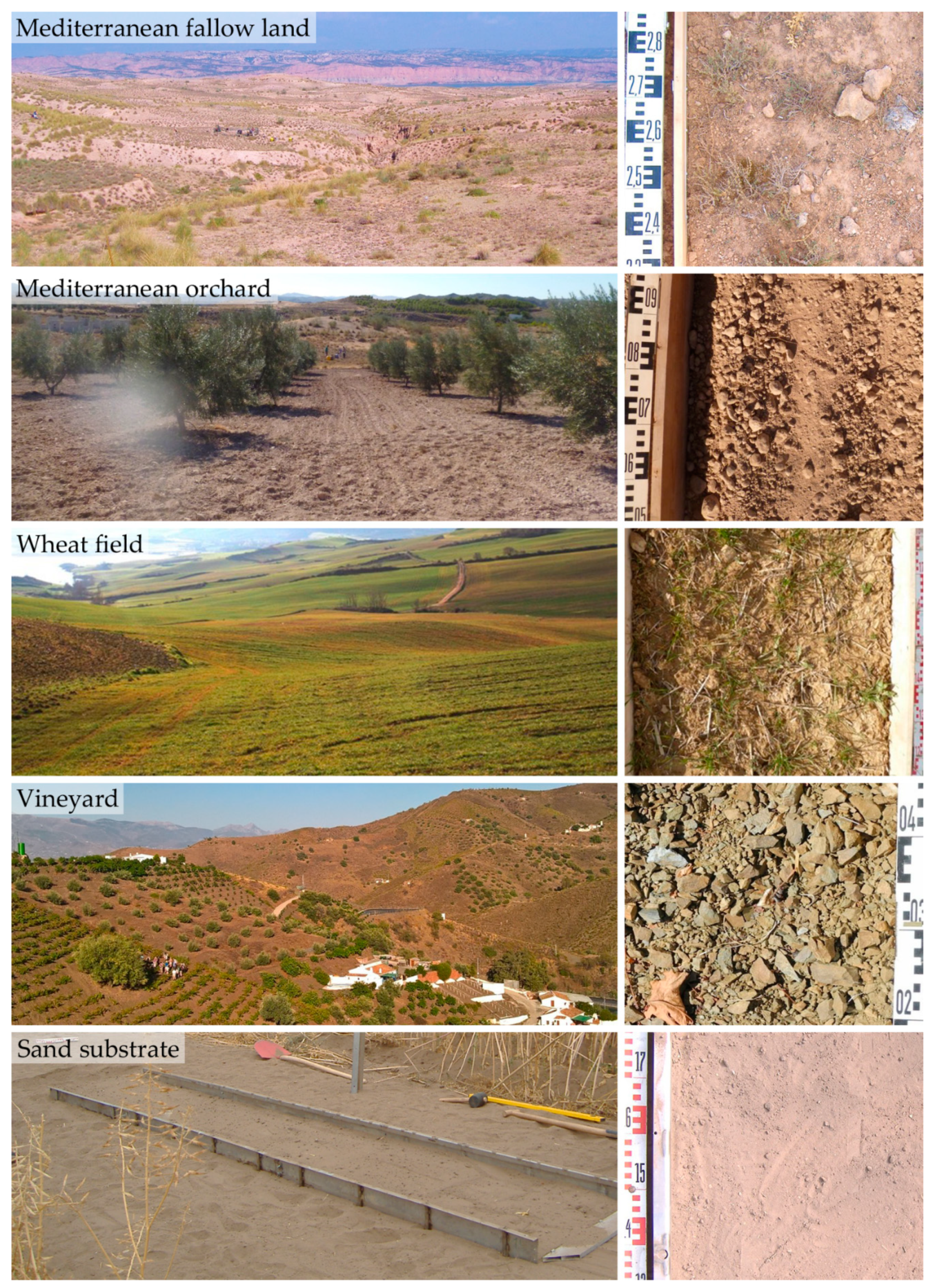
2.1. Locations and Surface Characteristics

Tests were performed on five different types of surfaces representing particular environments Table 1: (1) Mediterranean fallow, (2) Mediterranean orchard, (3) wheat field, (4) vineyard, and (5) sand substrate (Figure 1).
The environmental conditions of test plots were chosen according to recent developments in soil erosion research. All sites comprise a “hot-spot”-character concerning land use change and climate change. Agricultural sites are particularly threatened due to the combined action of management practices and climatic impact and often provide optimal conditions for both types of erosion including vast parcels and bare or sparsely vegetated surfaces during one or more stages of the cultivation cycle. Particularly vulnerable ecosystems such as semi-arid environments, which are widespread in the Mediterranean region, may respond with increased soil degradation and nutrient depletion, leading to desertification in the course of even minor land use or climatic changes [41]. The tested soils and substrates meet current research demands as stated by Poesen et al. [42] who see a research gap concerning erodibility of extreme substrates such as very fine-textured, very sandy and also stony substrates. An overview on the different landscape types and respective test surfaces is presented in Figure 1. Accordingly, the relating soil and surface characteristics of each type are aggregated in Table 1.

2.1.1. Mediterranean Fallow

The seven test plots of this site are located in Granada Province, Andalusia, at the easterly foothills of the Betic cordillera close to Baza at the catchment of reservoir Embalse de Negratín. The northern borders of the intramontane basin Hoya the Baza forms the border between the southernmost mountain range of the Betic Cordilleras, the Penibaetic System, and the Subbaetic System. Climatic conditions are semi-arid, including high-erosive torrential rainfalls normally occurring during spring and autumn, which account for the greatest part of annual precipitation of 200 to 350 mm and an annual mean temperature of 14.6 °C. [43,44]. As part of the post orogenic formation of the Guadalquivir basin, the Pliocene-Pleistocene pediment-landscape has been developing from Pliocene sediments and consists of marls with calcareous crusts [45]. The soils are severely degraded, calcaric Regosols (siltic and loamic) [46] and Leptosols [47] and have a very low Corg content (ca. 0.5%). The surface is covered by a very strong, more than 10 mm thick, physical depositional crust [48]. The potential impact of physical soil crusts is complex and varies immensely with particle structure, soil moisture and time [49,50]. They may delay actual soil detachment particularly for wind erosion [51] but show a strongly reduced infiltration capacity and are therefore very prone to runoff development, often leading to interrill- and rill-erosion [47,50,52,53]. One of the most important characteristics is the patchy distribution of semi-natural Garrigue-vegetation, which is a degradation stage of Mediterranean Maquis (Holm oak) succession. The plants are herbs, dwarf shrubs and sclerophyllous plants (e.g. Thymus vulgaris, Genista scorpius, Rosmarinus officinalis, Artemisia herba-alba, Lygeum spartum, Stipa tenacissima).

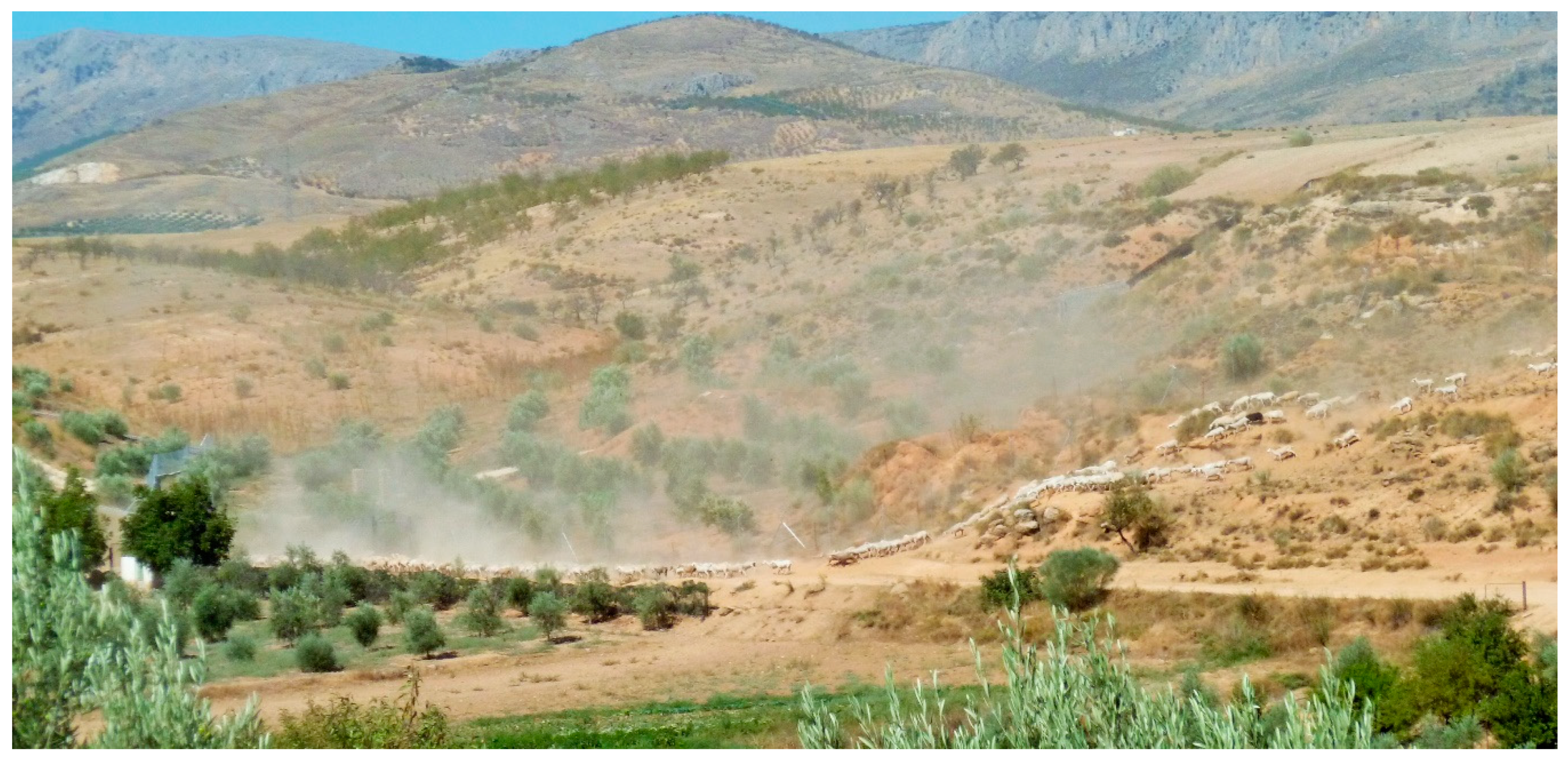
2.1.2. Trampling (Goats)

One test was set up to measure the impact of fresh goat trampling on the amount of eroded sediment. The test site was chosen to resemble other plots of the strongly crusted and degraded substrates, thus highlighting the impact of herding and trampling. Due to the complicated test procedure, which included the handling of animals, only one test was conducted that can give a hint to the approached question. The “Trampling (Goats)” test was not included in the group for statistical analysis but listed with only two values for comparison with other groups.

Management and Vulnerability

Experiments were conducted in a landscape of fallow land (of age 1 to >15 years) with extensive transhumance-related trampling and grazing pressure. The development of a protective vegetation coverage takes years and might be entirely prevented by grazing and trampling [52,54]. The sites are representative for large parts of the Mediterranean [48], which is considered a hot spot of climate change impact and prone to the expected effects of global change [55]. Concerning development of wind erosivity, most projections show a very likely decrease of cyclones and windstorms [56] but a higher probability to develop the hazardous category 1 strength [57].

2.1.3. Mediterranean Orchard

The three sites include two freshly ploughed olive orchards and one mango plantation in the process of construction. The orchards were also situated at the semi-arid Hoya de Baza with similar geomorphological, climatic and geological conditions (see Mediterranean fallow). The test on mango plantation was performed in the traditional wine region of Almáchar, Malaga in Southern Spain. Mean annual rainfall is 520 mm and mean annual temperature is 17.2 °C. Both soil substrates consisted of freshly tilled, shallow (0.3–0.4 m) calcaric Regosols with silty sand and loam as fine soil, forming a loose substrate of single grains or small aggregates, including a high stone content of fine and coarse gravel size. The recently ploughed olive orchard had a Corg content of 1.2% and the site freshly terraced for mango plantation a Corg content of ca. 4.1%. The very low Corg content of <2% (corresponding to about 3.5% organic material) can be classified as very prone to erosion [58], while the higher Corg content in the mango terrace may be due to mixing of substrate layers and available material from the surrounding.

Management and Vulnerability

Albeit extreme shallow and nutrient-poor soil substrates, traditional dry farming and also irrigated farming systems are installed not only on plains but very often on steeper slopes. For that purpose, the slopes are terraced by means of excavators and caterpillars, mixing and rearranging the soil substrate and altering chemical and physical parameters that also affect slope stability. The soil surface is generally bare throughout the year. The conversion of mainly stable hillslopes to new terraced plantations can be assumed as general practice in this area and also for larger parts of the Mediterranean. It is thus a recent land use change on a larger spatial scale that may have considerable effects with serious implications for slope stability and substrate mobilisation.

2.1.4. Wheat Field

The wheat field test sites La Tejería and Latxaga are located at the central western respectively central eastern part of Navarre in northern Spain at the south-western foothills of the Pyrenees. The climate is humid sub-Mediterranean with a mean annual precipitation of 755 to 861 mm and mean annual temperatures of 11.8 to 12.3 °C. The geology of this region comprises of clay marls, Pamplona grey marls, and sandstones, on which Vertic Cambisols developed with a silty clay and loamy structure. The soils are moderately shallow (0.5 to 1 m deep). The Corg content at both sites ranges between 2.5 to 3.5% and the fields were vegetated by young winter grain plants. The very high initial water content (47%) by the time of tests is common for this area at the time of year and is certainly one of the most important factors affecting measured soil erosion.

Management and Vulnerability

The agricultural fields were vegetated by young winter grain plants. They are part of a network of experimental agricultural watersheds of the Government of Navarre that comprise small watersheds (0.01 to 102 km2) with mainly agricultural land use with grains, vegetables or cattle and both contour-parallel and downhill tillage. Water erosion problems are common including high output of dissolved solids and suspended sediments [59,60]. Wind erosion can be assumed an important factor, particularly during periods of seedbed preparation. The sites can be considered representative for large parts of northern Spain [61]. The sites also resemble many other European agricultural environments; i.e., concerning management (non-irrigated, ploughed, winter grains, bare during particularly rainy periods, partly disadvantageous tillage practices) and soil character.

2.1.5. Vineyard

Four tests were performed in the traditional wine region of Almáchar, Malaga (Southern Spain). It is located at the southernmost Betic Cordillera mountain range Montes de Málaga. Mean annual rainfall is 520 mm and annual mean temperature 17.2 °C. The soil substrates are very shallow Eutric Leptosols developed on Palaeozoic dark metamorphic schist and quartzite with a coarse soil percentage of ca. 70% and total organic carbon of ca. 3% [62,63].

Management and Vulnerability

Management of the vineyards includes traditional steep slope viticulture practices such as manual topsoil working by means of hoes and application of organic manure (animals) and herbicides. The specific challenges of steep slope viticulture include a potentially high susceptibility to water erosion processes due to extreme slope angle and a subsequent constant threat of depletion from fine sediments including organic substance and nutrients [64]. Due to high stone content and lacking fine soil material at the surface, the substrates would not be considered prone to wind erosion.

2.1.6. Sand Substrate

The eight tests on this site were conducted on a semi-natural substrate at a roofed test field of Wageningen University in the Netherlands [65]. We chose this setting to investigate particularly sandy substrates such as found in the Netherlands, Belgium and northern Germany. They appear most often in costal zones and in inland dune areas, but are not completely restricted to these locations. The substrate could be addressed as Arenosol but is not addressed as soil here for the reason that it had been frequently disturbed and real soil development or horizons were not noticed. The substrate consisted mainly of fine (52%) and medium sand (35%), had a Corg content of 2.9% and was nearly bare of other considered aspects such as vegetation, stones or crust.

Management and Vulnerability

Agricultural use of sandy substrates is often associated with permanent pastures and forest. The substrate’s grain size distribution is suitable to represent coastal areas with dunes and beaches [66] that are particularly valuable in terms of coastal protection and generally threatened due to their exposition to wind and rain. This type of sandy substrate is also found at drifting sand areas of Belgium and the Netherlands, both generally managed as conservation area due to their crucial ecological function and vulnerability.

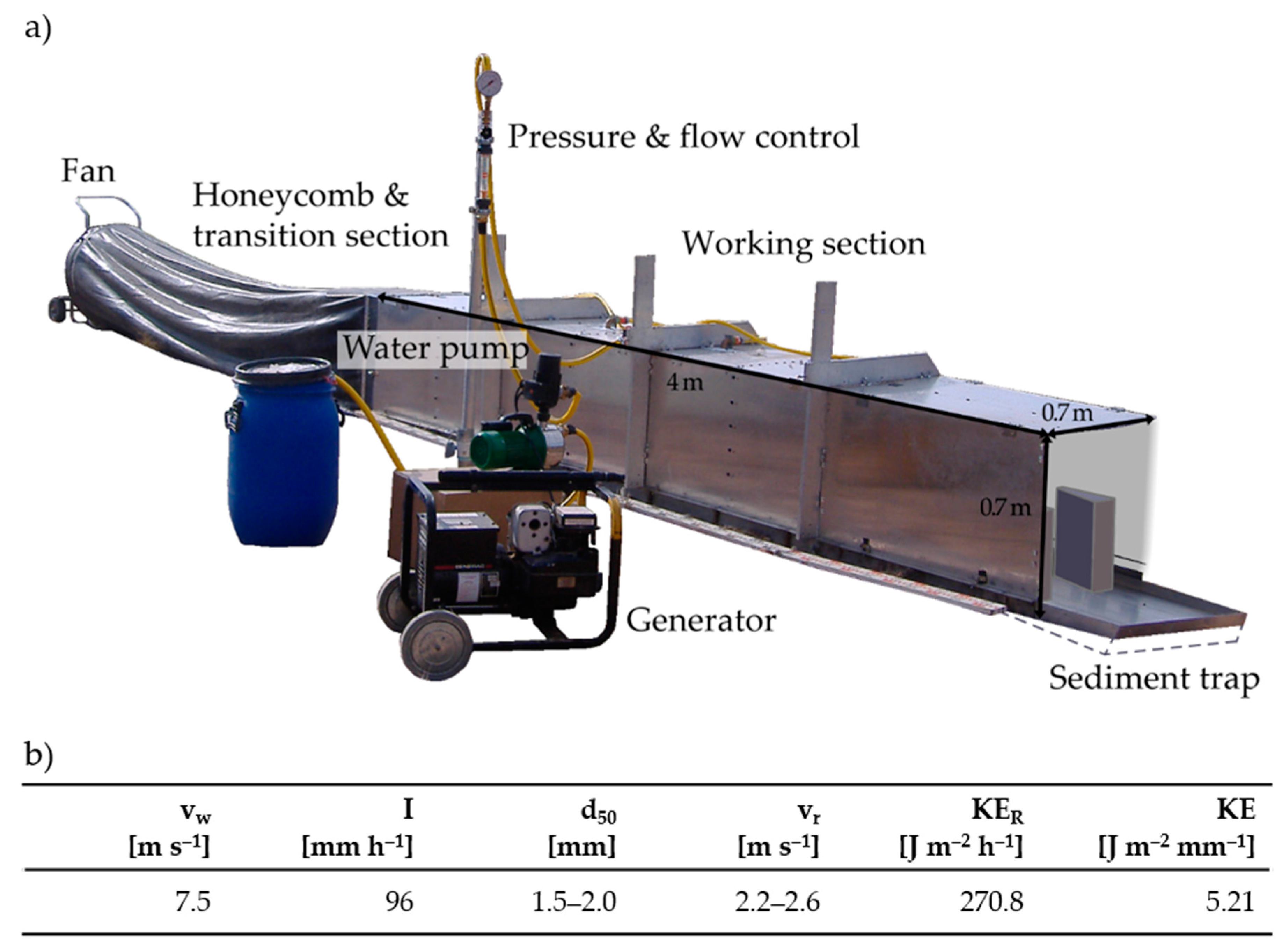
2.2. Experimental Procedure

Tests were conducted on in situ soil surfaces using the Trier Portable Wind and Rainfall Simulator (PWRS) (Figure 2a). For the tests presented in this study, the PWRS was used to apply wind and rainfall, including runoff generation. Compared tests were performed in a sequence (first, wind simulation; secondly, rainfall simulation) on the same test plot in order to keep substrate response due to spatial variability as low as possible and thus to measure the impact of erosion agents as explicitly as possible. The generated processes during the “rain”-test are mostly related to raindrop splash, (raindrop impacted) sheet erosion and initial rill development. The test device is known to be reliable regarding reproducibility of air-stream and rainfall as well as properties of the simulated rainfall [67,68]. Average wind velocity was 7.5 m s−1 at 0.3 m height. Compared to natural conditions, the generated rainfall represents a highly erosive heavy rain event, while wind is of a comparably lower intensity with the Beaufort scale number 5 (“fresh breeze”), which is adequate for wind erosion processes to be initiated [20,69]. Figure 2b shows the parameters of the test device.
Test plots were chosen as representative surfaces for five sites (Figure 1). Since micro-conditions between plots always differ and create variability in measured rates, repetitions are used to gain representative information about processes on a larger area. We estimated vegetation, stones and crust cover in percent of area, as important surface characteristics by visual observation of the respective test plot in the field. Inclination was measured in the field. Soil Corg was measured by loss on ignition at 500 °C and gravimetric soil water content (%) was measured by drying at 105 °C in the laboratory. Roughness was approached after [70]: Cr = (1 − L2/L1) × 100 with L1 = length of chain and L2 = length of plot. Test duration was 30 minutes for rain and 10 minutes for wind tests. Eroded material detached from the 2.2 m2 test area was collected by means of Wedgetraps (wind) and a gutter (rain/runoff), filtered (Munktell©, production number 3.104.185, <2 μm mesh-width), dried (105 °C) and weighed. Results were calculated to rates g·m−2·h−1.
The experimental setup’s specification, such as the applied test sequence and physical limitations, are addressed in [40,65]. It is necessary to be aware of the general problems concerning interpretation and upscaling of experimental data so that the information can be adequately applied. The experiments fill the gap between “observation” and “model” and provide valuable data that are basis for process understanding and reliable modelling.

2.3. Statistical Analysis
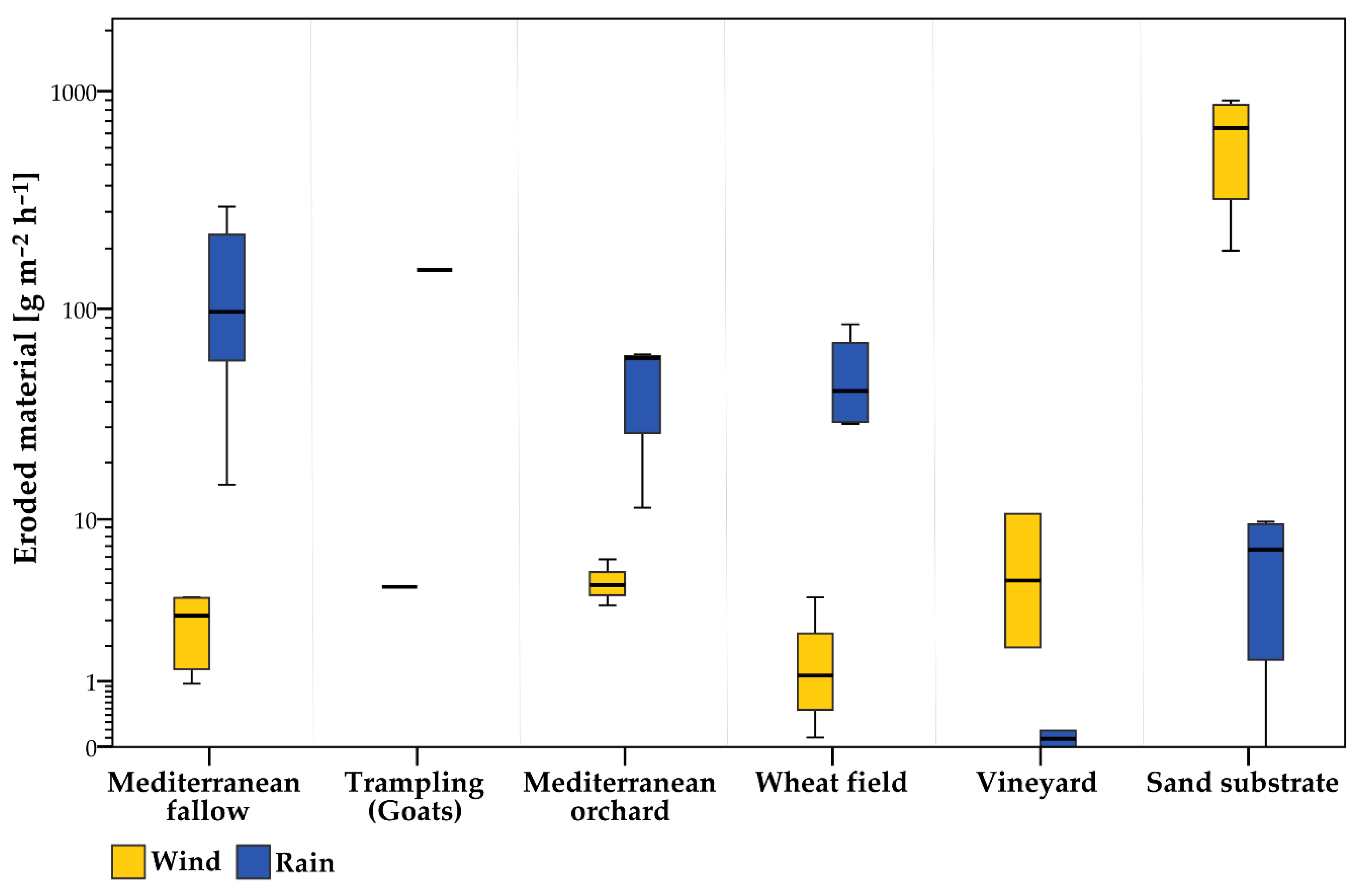
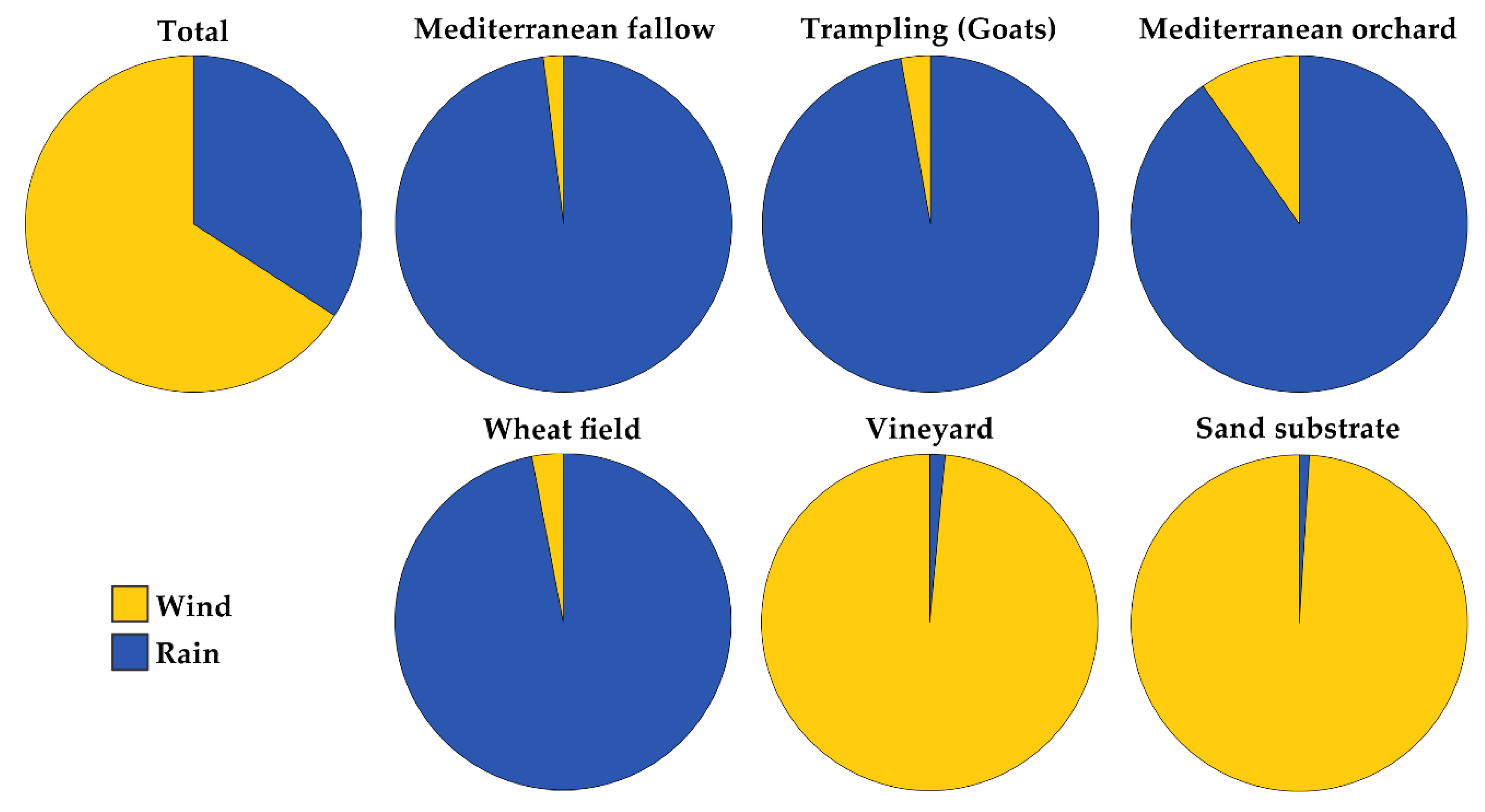
Since not all data groups were normally distributed (Kolmogorov-Smirnov/Shapiro Wilk), Kruskal-Wallis (H-test) and Dunn-Bonferroni-Post-hoc-tests were performed to find central tendencies in the datasets. Correlation analysis was performed using the Spearman rank coefficient. Simple comparison may still be conducted by calculation of the mean. Statistical tests were performed with SPSS Statistics 25 [71].

3. Results

In total, 40 plot-scale experiments were conducted, of which 20 tests were wind simulations and 20 rainfall simulations on corresponding 20 test plots at the five presented sites (Table 2). Mean erosion values for each erosive agent ranged from 1.55 to 618 g·m−2·h−1 for wind and from 0.09 to 133.9 g·m−2·h−1 for rain eroded material over all tested sites. The highest rain erosion rates (295.47 and 219.86 g·m−2·h−1) were measured on crusted Mediterranean fallow land, while the lowest rates (0.00 and 0.19 m−2·h−1) were measured on slate covered vineyard soils. Sand substrate was most susceptible to wind erosion (908.19 g·m−2·h−1), while minimum wind erosion was measured on water saturated winter wheat fields (0.10 g·m−2·h−1).
We measured highest mean water erosion rate (133.90 g·m−2·h−1) on Mediterranean fallow with 14.92 g·m−2·h−1as the lowest and 295.47 g·m−2·h−1 as the highest value. For wind erosion, we found a low mean rate compared with all other tested environments (2.66 g·m−2·h−1). While some plots produce low wind and rain erosion, others produce high wind erosion but low rain rates and vice versa. With 151.36 g·m−2·h−1, rain erosion on the trampling (goats) plot exceeds average erosion on Mediterranean plots (133.90 g·m−2·h−1). Wind erosion rate 4.41 g·m−2·h−1 is also one of the highest measured on all Mediterranean plots and twice the value of mean erosion on all Mediterranean plots (2.66 g·m−2·h−1). In comparison to mean rain erosion rate on crusted sites (133.90 g·m−2·h−1), the rate on Mediterranean orchard soils are much lower (44 g·m−2·h−1), but mean wind erosion rate is significantly higher (4.73 and 2.66 g·m−2·h−1, respectively). On down-hill directed clod-furrow pattern, a much greater transport rates for rain (61.48 and 59.08 g·m−2·h−1) were measured than on the plantation under construction without such features (11.43 g·m−2·h−1). Wind erosion is lower on orchard soils (4.5 and 3.45 g·m−2·h−1) than on plantation under construction (6.23 g·m−2·h−1), which is also the second highest value from all tests apart from the sand sediment. On wheat field, the lowest wind erosion rates (mean 1.55 g·m−2·h−1) and second highest water erosion rates (mean 50.29 g·m−2·h−1) of all sites were measured. The mean erosion rates on the vineyard substrate are comparably low in the case of water erosion (0.08 g·m−2·h−1) and second highest for wind erosion (6.26 g·m−2·h−1), but with a very high variability. Water erosion on the sand substrate was comparably low (6.05 g·m−2·h−1), but it produced the highest wind erosion rates with a mean rate of 618.62 g·m−2·h−1 and highest rate of 908.19 g·m−2·h−1. Figure 3 shows the data arranged as boxplots.
Percentages (%) of eroded sediment for wind and rain, respectively, were found to be 2:98 (Mediterranean fallow), 11:89 (Mediterranean orchard), 3:97 (wheat field), 98:2 (vineyard) and 99:1 (sand substrate) (Figure 4).
From the H-test results (Table 3), we can derive that there are differing tendencies between groups 1–6 (sites). The Dunn-Bonferroni- Post-hoc-tests showed for wind erosion that only group 4 and 6 show significant differences (adjusted significance 0.017), while no significant differences were found for rain erosion. This means that the statistical analysis found all sites to produce similar erosion output for both wind erosion and rain erosion. The only exception is the case of a comparison between wind erosion output from sites wheat field and sandy substrate, where a significant difference was found. These results can be expected from the initial explanation concerning number, distribution and range of values.
Correlation analysis (Table 4) finds wind erosion positively relating to the available fine material on the surface and negatively with soil H2O, slope, vegetation and roughness.
Rain erosion correlates strongly with crust and vegetation and negatively with fine soil and Corg, indicating that crust is the most important factor considering high water erosion rates in our tested environments.

4. Discussion

Wind erosion and rain erosion were both found to occur in every tested environment, with often one type prevailing under specific conditions (Figure 3). Measured total erosion and impact on total soil erosion for each erosive agent differed according to site.
The high variability of results reflects the inherent complexity of the soil surface interacting with respective erosion agent. Rainfall simulations are generally known for their highly variable output [46,72,73,74]. However, the values presented here appear consistent in terms of range of values and plausible concerning expected substrate response.

4.1. Mediterranean Fallow

Semi-arid regions are known to be prone to erosion by both wind and water [27,75]. Our results show a complex situation concerning total measured values as well as the relationship between wind and rain tests of the same test plot. The substrates comprise a large share of the most easily erodible fractions silt and fine sand, but they do not always produce high erosion rates. The key explanation is that susceptibility to runoff generation and erosion by water and wind is to a great extent determined by specific surface characteristics such as crusts, stone cover, roughness, and vegetation - particularly in arid and semi-arid environments [76].
The strong physical crust acts as a protection against initial soil erosion processes such as raindrop splash, bombardment and creep. Crusts increase the threshold shear stress necessary for the initiation of erosion, decrease water infiltration and increase runoff [77,78]. The prevailing type of runoff is thus Hortonian overland flow. The transported and captured material during the first stage of the detachment process is loosely on the surface sitting material, which has already been loosened before the test/erosion event. Only when the crust is destroyed, e.g., by longer lasting wetting, scouring, initial rill development or hoof impact, fresh erosion can occur. This is particularly true for wind erosion, which can only lead to fresh scouring if travel and fetch-distance of saltating particles is long enough. Following the concept of fetch effect including avalanching, aerodynamic feedback and soil resistance mechanism, we can expect an increasing sediment flux with increasing field length [79]. However, the experimental plot length is limited to 4 m, which is not enough to develop this effect, and the steady air stream lacks the erosive energy of instant velocity changes and gusts. Thus, measured rates must be interpreted as the least possible amount of erodible material provided by the respective soil or substrate surface. It can be assumed that variations in erosion rates are associated with 1. a higher amount of easily available sediment on the surface and 2. micro-fissures in the crust leading to decreased cohesive forces and increased erodibility. The overall high variability of results points to complex interactions between not yet addressed soil parameters and supports scientists calling for a multidisciplinary research approach particularly in semi-arid and arid regions [80].

4.2. Trampling or Tillage Impact

Test results show an immense possible impact of animal trampling on soil erosion, particularly due to rise in sediment availability. Prior to trampling, erosion is supply limited, but it shifts to transport limited when the crusted surface is destroyed. By that, erodible material and thus much higher erosion rates are generated. The results are in accordance with [54] who found animal trampling a considerable trigger for the generation of easily erodible sediment.
Field observations also indicate the highly effective mechanism of entrainment of sediment due to animal trampling—even on sites without measurable wind erosion (Figure 5). Moving animals of different sizes (including hooves and paws) can be a crucial impulse for erosion in two ways: first, the sediment and/or biological crust is destroyed, thus threshold shear velocity is strongly reduced and easily available sediment generated [81].
Second, entrainment of soil particles by active lifting into the air stream even if lifting and dragging force of the airflow is not strong enough for entrainment.
The effect of animals or tillage during a wind event may act as a trigger for the initiation of wind erosion processes, and thus on surfaces were no wind erosion is measured by experimental procedures. Mechanisms and effect of this animal or tillage impact therefore differ from those during “tillage erosion” [82,83] but may be a paramount, yet not quantified, factor to assess soil loss budget for certain regions.

4.3. Mediterranean Orchard

The substrate was a similar silt loam with an additional high stone content. In contrast to site 1, the surface was not crusted, but of a loose single grain structure. The cohesionless surface was generated by ploughing the former crusted surface underneath the trees, which is a traditional practice in rainfed orchard management. Compared to crusted sites, we measured a decrease in water erosion rates and an increase in wind erosion rates. In the case of water erosion, the single grain structure enhanced infiltration, and thus less runoff was generated to entrain and transport soil particles. Although more material should be easily available because of a strongly reduced critical shear stress, there was less water to transport the sediment downhill. In the case of wind erosion, sediment availability is high enough to generate higher erosion rates with the same erosive energy as on crusted sites.
Compared to the crusted Mediterranean plots, results support findings that expect physical crusts to prevent fresh wind erosion by fixation of soil particles inside the cohesive crust structure [84,85]. Compared to other cohesionless substrates such as the sandy substrate, we find much lower rates for the loamy material of orchard soils. This may be partly explained by the higher cohesive forces binding silt and clay particles.
A downhill furrow pattern on two of the three plots might have acted as down flow-directed roughness elements, enhancing water erosion but not wind erosion, which was higher on the plane surface of a plantation under construction. Wind erosion, particularly in dry areas and of fine textured substrate, is found to be very much dependent on air humidity [86], which has not been measured in this study but might have been a crucial factor for this difference in erosion rates. We found that erosion on these sites mostly are not supply limited, but transport limited, which means that these sites are particularly threatened by climate change related increase in rainfall or wind kinetic energy. Our study supports findings that consider semi-arid areas particularly sensitive to aggressive agricultural management practices [87,88,89]. Here, an adapted land use management has great potential to mitigate degradation processes related to climate change.

4.4. Wheat Field

The clay loam of these sites is slightly more cohesive than other substrates, which is particularly important in the case of a high water content. Due to abundant precipitation during the experimental period, all tests were conducted on saturated soils (47% H2O). This also explains the high water erosion rates caused by an immediate generation of saturation overland flow in contrast to the Hortonian overland flow generated on crusted soils caused by poor infiltration capacity. The measurement results are in line with Giménez et al. [90] who state that at these particular sites (Latxaga and La Tejería) overland flow occurs only if the soil is saturated. Transport of particles was then enhanced by increased matrix potential. The high water content also effectively prevented particles from detachment by air stream and explains low wind erosion rates [91,92]. Bergametti et al. [93] even suggest to neglect wind erosion completely up to 12 hours after rainfall for the Sahel region. Erosion only takes place when the wind dries the top grain layers, thus reducing adhesion forces of the cohesive loam material. However, we measured wind erosion even on saturated soils within an hour of antecedent rainfall, but higher wind erosion rates can be expected if soil is not water saturated.

4.5. Vineyard

Results on extremely stony substrates of this site demonstrate that even under extreme conditions such as this high percentage of stone coverage, erosion processes by rain and also wind may be activated. Water erosion is low but wind erosion is quite high, but it has to be noted that one high value was made up mostly by one single piece of slate, which was airborne due to its light weight and flat shape. The results should therefore be complemented by further studies on these substrates, which show, however, quite a high wind erosion potential, which was also evident on site. Frequently visually observed were airborne material in form of dust trails, triggered by moving animals or people with simultaneous wind gusts or thermal uphill air movements. Dry gravel transport, as investigated by Gabet et al. [94], may also be a frequent source of surficial disturbance. Movement-triggered wind erosion would be a crucial aspect to reliably quantify emitted dust material from these sites. Water erosion was mostly prevented by a high infiltration rate of the coarse substrate, a finding also observed by Biddoccu et al. and Novara, et al. [95,96]. For similar sites, Kirchhoff et al. [97] found that the use of heavy machinery in conventionally managed vineyards may lead to higher erosion rates compared to organic vineyards without heavy machinery, and a profound subsurface flow can be expected such as observed in the vineyards of the Ruwer-Mosel valley [98].

4.6. Sand Substrate

This substrate was the substrate most susceptible to wind erosion by far. Compared to Mediterranean orchard soils (without crust), the results are two scales higher on the sandy substrate than on the loam soils. Low water erosion was mainly caused by a high infiltration with no or weakly developed saturation runoff. Once runoff was established, transport of cohesionless sand particles on the surface with a very low roughness (Cr = 0) and slope (1°) was initiated. Main factor controlling these erosion rates is grain size distribution of substrate with >50% fine sand in combination with a complete lack of stabilizing features. The here measured erosion rates were also the highest for all tests by wind and by water, indicating the greatest general potential to mobilize substrate. This substrate was also particularly sensitive to the combined action of wind and water during the impact of wind-driven raindrops [99], indicating a possible relation between susceptibility to both types of erosion. Transport by wind is a major erosion factor also on Belgian inland dunes, implicating positive effects such as a prevention of stable revegetation, but also negative effects such as a complete loss of eroded material during wind erosion events [100]. These erosion rates show the tremendous effect a land use change in terms of the removal of vegetation cover, which could generate on sandy substrates, as found at specific areas in the Netherlands, Belgium and northern Germany not only at coastal zones. The wind erosion potential on these sites in agricultural use can be considered hazardous. Compared to results on other plots (Figure 3), we find here the total mean rates more than three times as much as the next higher mean rates from goat destroyed crust and fallow sites.

4.6.1. Percentages of Erosion

The ratios suggest prevailing types of soil erosion for all environments, but because applied erosive energy differs between simulated rain and wind (see Section 2.2), they cannot stand alone but must be interpreted in relationship to each other.
The percentage distribution of eroded sediment derived by means of the wind and rainfall simulator seems to differ with respective tested site (Figure 4). The percentages show relative susceptibility to either type of erosion related to specific site:
We found minor shares for wind erosion on Mediterranean fallow (2:98) and wheat field (3:97), a greater susceptibility of Mediterranean orchard soils (11:89) and highest shares in vineyard (98:2) and sand substrate (99:1). The findings are plausible in terms of expected erosion values for various surface features such as crusts and tilled soils but also show surprising results for the stony vineyard substrates. Additionally, results on sandy substrates are very sharp and point to a potentially hazardous substrate loss for comparable substrates if left uncovered.

4.6.2. Factors Influencing Erosion Rates on All Sites

Findings from rank correlation suggest that wind erosion mostly depends on the available fine material on the dry surface, while other factors such as roughness, slope and vegetation present unfavorable conditions. Positive correlation of rain erosion with vegetation is here to be interpreted in terms of the patchily distributed Garrigue-vegetation, which seems to enhance runoff and erosion rates. It has to be noted that correlation analysis is strongly influenced by the very high wind erosion rates on plots with nearly no features except sandy (= fine soil) surface material.
Comparing scales, wind erosion rates are generally found one scale smaller than water erosion rates except on sandy substrate, where wind erosion rates are two scales higher that water erosion rates.
The sites Mediterranean fallow (crusted), Mediterranean orchard (crust and upper horizon destroyed by ploughing) and goat trampled (surficial crust destroyed by hoof-impact) can be compared considering the structure of the topmost soil/substrate layer. From the measured rates, it may be derived that the destruction of the upper substrate layer may enhance wind erosion the deeper the destruction reaches and decreases water erosion only in the case of a deeper destruction such as ploughing. The impact of surface destruction such as by tillage or herding can be expected to be one of the most important factors influencing potential erodibility on a global scale and may affect great proportions of arable land worldwide and particularly in vulnerable environments. This fact also offers a great opportunity in terms of resource protection, since a clever adaption to soil substrate and climatic factors can be considered a valuable option to adapt and mitigate the impact of climate change and to face socio-economic demands of a growing population. In particular, minimum to no-till options seem to prevent wind erosion as well as water erosion due to intact shallow crust or sealing, persisting crop residues and beneficial impact on soil organisms and soil structure [101,102].
The hypotheses were both found to be supported by findings of our experimental-empirical study.
• All surfaces produce soil erosion due to the action of wind and rain.
On each site, both types of erosion were measured, indicating a strong need to focus on both wind and water erosion particularly on agricultural sites. The here presented test setup showed that wind erosion was most powerful on cohesionless sandy substrate, while erosion by rain was the highest on crusted Mediterranean fallow sites. The crusted surfaces prevent erosion by wind - but not by water - which is even aggravated if it is destroyed by, e.g. herding animals. In this case, both wind and rain erosion rates multiply. Wind erosion rates are then equal to those on cohesionless silty substrate on ploughed orchard soils, which indicates a shift from supply limited to transport limited erosion. Rain erosion rates on Mediterranean orchard sites remarkably resemble those on the wheat field site under saturated conditions. Even substrates with extreme surface conditions such as an almost complete coverage by slate stones are susceptible to soil erosion. The extremely stony vineyard produced quite high wind erosion rates but nearly no water erosion despite development of runoff. Highest total erosion was measured on sand substrate, followed by Mediterranean fallow/goat trampled crust, waterlogged wheat field and Mediterranean orchard, and lowest on slate covered vineyard.
• Relative impact of soil erosion agent differs corresponding to soil site characteristics.
Relations between rain erosion and wind erosion rates show that both erosive forces may have an impact on total soil erosion depending on site characteristics. Water erosion is the most important erosion agent on Mediterranean fallow as well as on waterlogged wheat field sites. On sandy substrate, wind erosion exceeds water erosion by far, as is the case on slate covered vineyard slopes. Mediterranean orchard soils that have a loose cohesionless structure due to ploughing are more susceptible to wind erosion than their crusted equivalent but less affected by water erosion.

5. Conclusions

The results may raise awareness of scientist, farmers and decision makers about the potential impact of both erosive forces on agricultural sites. Knowledge about the exact relationship is a necessary step towards implementation of highly efficient soil protection strategies adapted to specific soil surface conditions-related erosion susceptibility. Relations between rain erosion and wind erosion amounts show that impact on total soil erosion depends on soil and substrate surface characteristics related to sites and applied management. The highest erosion rates were measured on sand substrate, followed by Mediterranean fallow/goat trampled crust, wheat field and Mediterranean orchard, and lowest on slate covered vineyard. Even locations with extreme surface conditions such as an almost complete coverage by slate stones are susceptible to soil erosion.
Water erosion is the most important erosion agent on Mediterranean fallow as well as on wheat field sites. On sandy substrate, wind erosion exceeds water erosion by far.
The findings are important in terms of climate change and (climate change-driven) anthropogenic land use and land cover change under which extreme substrates are increasingly reactivated for food production. Erosion rates potentially rise due to higher pressure generated by land use change. A clever adaption to soil substrate and climatic factors can be considered a valuable option to adapt and mitigate the impact of climate change and to face socio-economic demands of a growing population.

Author Contributions

conceptualization, M.M., T.I., W.F., J.B.R.; methodology, M.M., T.I., W.F., J.B.R.; validation, M.M., T.I., J.B.R.; formal analysis, M.M.; investigation, M.M., T.I., W.F., M.S., J.R.-C., J.B.R.; data curation, M.M.; writing—original draft preparation, M.M.; writing—review and editing, M.M., T.I., W.F., J.R.-C.; visualization, M.M., T.I.; supervision, J.B.R..; funding acquisition, M.M., J.B.R.

Funding

This research was funded by the Deutsche Forschungsgemeinschaft, grant number RI 835/3 and the research fund of Trier University.

Acknowledgments

We would like to thank the Deutsche Forschungsgemeinschaft (project RI 835/3) and the Research Fund of Trier University for funding the study. We are grateful to J. Casalí for providing access and support during field tests at test sites of the Government of Navarre La Tejería and Latxaga, Leo Stroosnijder and Harm Boesveld for providing the Willem Genet Tunnel of Wageningen University and Pepe Gámez for providing and support during field tests in Almáchar. We also like to thank the unknown reviewers for their valuable support to improve the paper.

Conflicts of Interest

The authors declare no conflict of interest. The funders had no role in the design of the study; in the collection, analyses, or interpretation of data; in the writing of the manuscript, or in the decision to publish the results.

References

  1. Mann, C.; Garcia-Martin, M.; Raymond, C.M.; Shaw, B.J.; Plieninger, T. The potential for integrated landscape management to fulfil Europe’s commitments to the Sustainable Development Goals. Landsc. Urban. Plan. 2018, 177, 75–82. [Google Scholar] [CrossRef]
  2. Montanarella, L.; Pennock, D.J.; McKenzie, N.; Badraoui, M.; Chude, V.; Baptista, I.; Mamo, T.; Yemefack, M.; Singh Aulakh, M.; Yagi, K.; et al. World’s soils are under threat. Soil 2016, 2, 79–82. [Google Scholar] [CrossRef]
  3. Goudie, A.S. Desert dust and human health disorders. Environ. Int. 2014, 63, 101–113. [Google Scholar] [CrossRef] [PubMed]
  4. Duniway, M.C.; Pfennigwerth, A.; Fick, S.; Nauman, T.; Belnap, J.; Barger, N. Wind erosion and dust from US drylands: A review of causes, consequences, and solutions in a changing world. Ecosphere 2019, 10, e02650. [Google Scholar] [CrossRef]
  5. Baumgart, P.; Eltner, A.; Domula, A.R.; Barkleit, A.; Faust, D. Scale dependent soil erosion dynamics in a fragile loess landscape. Z. Für Geomorphol. 2017, 61, 191–206. [Google Scholar] [CrossRef]
  6. Nadal-Romero, E.; Martínez-Murillo, J.F.; Vanmaercke, M.; Poesen, J. Scale-dependency of sediment yield from badland areas in Mediterranean environments. Prog. Phys. Geogr. Earth Environ. 2011, 35, 297–332. [Google Scholar] [CrossRef]
  7. Borrelli, P.; Robinson, D.A.; Fleischer, L.R.; Lugato, E.; Ballabio, C.; Alewell, C.; Meusburger, K.; Modugno, S.; Schütt, B.; Ferro, V.; et al. An assessment of the global impact of 21st century land use change on soil erosion. Nat. Commun. 2017, 8, 1–13. [Google Scholar] [CrossRef]
  8. Borrelli, P.; Lugato, E.; Montanarella, L.; Panagos, P. A New Assessment of Soil Loss Due to Wind Erosion in European Agricultural Soils Using a Quantitative Spatially Distributed Modelling Approach. Land Degrad. Dev. 2017, 28, 335–344. [Google Scholar] [CrossRef]
  9. Oost, K.V.; Quine, T.A.; Govers, G.; Gryze, S.D.; Six, J.; Harden, J.W.; Ritchie, J.C.; McCarty, G.W.; Heckrath, G.; Kosmas, C.; et al. The Impact of Agricultural Soil Erosion on the Global Carbon Cycle. Science 2007, 318, 626–629. [Google Scholar] [CrossRef]
  10. Panagos, P.; Borrelli, P.; Poesen, J.; Ballabio, C.; Lugato, E.; Meusburger, K.; Montanarella, L.; Alewell, C. The new assessment of soil loss by water erosion in Europe. Environ. Sci. Policy 2015, 54, 438–447. [Google Scholar] [CrossRef]
  11. Visser, S.M.; Sterk, G.; Ribolzi, O. Techniques for simultaneous quantification of wind and water erosion in semi-arid regions. J. Arid Environ. 2004, 59, 699–717. [Google Scholar] [CrossRef]
  12. Funk, R.; Frielinghaus, M. Winderosion. In Handbuch der Bodenkunde; Blume, H.P., Ed.; Wiley: Berlin, Germany, 1998; pp. 1–22. [Google Scholar]
  13. Hoffman, O.; Yizhaq, H.; Boeken, B.R. Small-scale effects of annual and woody vegetation on sediment displacement under field conditions. Catena 2013, 109, 157–163. [Google Scholar] [CrossRef]
  14. Beniston, M.; Stephenson, D.B.; Christensen, O.B.; Ferro, C.A.T.; Frei, C.; Goyette, S.; Halsnaes, K.; Holt, T.; Jylhä, K.; Koffi, B.; et al. Future extreme events in European climate: An exploration of regional climate model projections. Clim. Chang. 2007, 81, 71–95. [Google Scholar] [CrossRef]
  15. Guglielmi, G. Hurricanes slow their roll around the world. Nature 2018, 558, 15–16. [Google Scholar] [CrossRef]
  16. Intergovernmental Panel on Climate Change (IPCC). AR5 Synthesis Report: Climate Change 2014; IPCC: Geneva, Switzerland, 2014. [Google Scholar]
  17. Chepil, W.; Woodruff, N. The physics of wind erosion and its control. Adv. Agron. 1963, 15, 211. [Google Scholar]
  18. Ravi, S.; D’Odorico, P.; Breshears, D.; Field, J.; Goudie, A.; Huxman, T.; Li, J.; Okin, G.; Swap, R.; Thomas, A.; et al. Aeolian processes and the biosphere. Rev. Geophys. 2011, 49, Rg3001. [Google Scholar] [CrossRef]
  19. Chepil, W.S. Conversion of Relative Field Erodibility to Annual Soil Loss by Wind. Soil Sci. Soc. Am. J. 1960, 24, 143–145. [Google Scholar] [CrossRef]
  20. Katra, I.; Gross, A.; Swet, N.; Tanner, S.; Krasnov, H.; Angert, A. Substantial dust loss of bioavailable phosphorus from agricultural soils. Sci. Rep. 2016, 6, 24736. [Google Scholar] [CrossRef]
  21. Buschiazzo, D.; Funk, R. Wind Erosion of Agricultural Soils and the Carbon Cycle. In Soil Carbon: Science, Management, and Policy for Multiple Benefits; CABI: Wallingford, UK, 2014. [Google Scholar]
  22. Intergovernmental Panel on Climate Change IPCC. IPCC Special Report on Climate Change, Desertification, LandDegradation, Sustainable Land Management, Food Security, and Greenhouse Gas Fluxes in Terrestrial Ecosystems; IPCC: Geneva, Switzerland, 2019; p. 43. [Google Scholar]
  23. García-Ruiz, J.M.; Beguería, S.; Nadal-Romero, E.; González-Hidalgo, J.C.; Lana-Renault, N.; Sanjuán, Y. A meta-analysis of soil erosion rates across the world. Geomorphology 2015, 239, 160–173. [Google Scholar] [CrossRef]
  24. Savat, J.; De Ploey, J. Sheetwash and rill development by surface flow. In Badland Geomorphology and Piping; Bryan, R.B., Yair, A., Eds.; Geobooks: Norwich, UK, 1982; pp. 113–126. [Google Scholar]
  25. Keesstra, S.; Mol, G.; De Leeuw, J.; Okx, J.; Molenaar, C.; De Cleen, M.; Visser, S. Soil-Related Sustainable Development Goals: Four Concepts to Make Land Degradation Neutrality and Restoration Work. Land 2018, 7, 133. [Google Scholar] [CrossRef]
  26. Ravi, S.; Breshears, D.D.; Huxman, T.E.; D’Odorico, P. Land degradation in drylands: Interactions among hydrologic–aeolian erosion and vegetation dynamics. Geomorphology 2010, 116, 236–245. [Google Scholar] [CrossRef]
  27. Bullard, J.E.; Livingstone, I. Interactions between Aeolian and Fluvial Systems in Dryland Environments. Area 2002, 34, 8–16. [Google Scholar] [CrossRef]
  28. Siegmund, N.; Funk, R.; Koszinsky, S.; Buschiazzo, D.E.; Sommer, M. Effects of low-scale landscape structures on aeolian transport processes on arable land. Aeolian Res. 2018, 32, 181–191. [Google Scholar] [CrossRef]
  29. Ho, T.D.; Valance, A.; Dupont, P.; Ould El Moctar, A. Aeolian sand transport: Length and height distributions of saltation trajectories. Aeolian Res. 2014, 12, 65–74. [Google Scholar] [CrossRef]
  30. Iversen, J.D.; Rasmussen, K.R. The effect of wind speed and bed slope on sand transport. Sedimentology 1999, 46, 723–731. [Google Scholar] [CrossRef]
  31. Shao, Y.; Lu, H. A simple expression for wind erosion threshold friction velocity. J. Geophys. Res. 2000, 105, 22437–22443. [Google Scholar] [CrossRef]
  32. Kaiser, A.; Neugirg, F.; Schindewolf, M.; Haas, F.; Schmidt, J. Simulation of rainfall effects on sediment transport on steep slopes in an Alpine catchment. In Sediment Dynamics from the Summit to the Sea; IAHS-AISH publication/IAHS Press: New Orleans, LA, USA, 2015; Volume 367, pp. 43–50. [Google Scholar]
  33. Sachs, E.; Sarah, P. Effect of Raindrop Temperatures on Soil Runoff and Erosion in Dry and Wet Soils. A Laboratory Experiment. Land Degrad. Dev. 2017, 28, 1549–1556. [Google Scholar] [CrossRef]
  34. De Lima, J.; Isidoro, J.; De Lima, I.; Singh, V. Longitudinal Hillslope Shape Effects on Runoff and Sediment Loss: Laboratory Flume Experiments. J. Environ. Eng. 2018, 144, 04017097. [Google Scholar] [CrossRef]
  35. Iserloh, T.; Wirtz, S.; Seeger, M.; Marzolff, I.; Ries, J. Erosion processes on different relief units: The relationship of form and process. Cuad. Investig. Geogr. 2017, 43, 171–187. [Google Scholar] [CrossRef]
  36. Dunne, T.; Malmon, D.V.; Mudd, S.M. A rain splash transport equation assimilating field and laboratory measurements. J. Geophys. Res. Earth Surf. 2010, 115, F01001. [Google Scholar] [CrossRef]
  37. Furbish, D.J.; Hamner, K.K.; Schmeeckle, M.; Borosund, M.N.; Mudd, S.M. Rain splash of dry sand revealed by high-speed imaging and sticky paper splash targets. J. Geophys. Res. 2007, 112, F01001. [Google Scholar] [CrossRef]
  38. Cornelis, W.M.; Oltenfreiter, G.; Gabriels, D.; Hartmann, R. Splash-saltation of sand due to wind-driven rain: Vertical deposition flux and sediment transport rate. Soil Sci. Soc. Am. J. 2004, 68, 32–40. [Google Scholar] [CrossRef]
  39. De Lima, J.L.M.P.; van Dijk, P.M.; Spaan, W.P. Splash-saltation transport under wind-driven rain. Soil Technol. 1992, 5, 151–166. [Google Scholar] [CrossRef]
  40. Marzen, M.; Iserloh, T.; de Lima, J.L.M.P.; Ries, J.B. The effect of rain, wind-driven rain and wind on particle transport under controlled laboratory conditions. Catena 2016, 145, 47–55. [Google Scholar] [CrossRef]
  41. Cantón, Y.; Solé-Benet, A.; de Vente, J.; Boix-Fayos, C.; Calvo-Cases, A.; Asensio, C.; Puigdefábregas, J. A review of runoff generation and soil erosion across scales in semiarid south-eastern Spain. J. Arid Environ. 2011, 75, 1254–1261. [Google Scholar] [CrossRef]
  42. Poesen, J. Soil erosion in the Anthropocene: Research needs: Soil erosion in the Anthropocene. Earth Surf. Process. Landf. 2018, 43, 64–84. [Google Scholar] [CrossRef]
  43. Corella, J.P.; Valero-Garcés, B.L.; Serrano, S.M.V.; Brauer, A.; Benito, G. Three millennia of heavy rainfalls in Western Mediterranean: Frequency, seasonality and atmospheric drivers. Sci. Rep. 2016, 6, 38206. [Google Scholar] [CrossRef] [PubMed] [Green Version]
  44. Diodato, N.; Bellocchi, G. Landscape Scales of Erosive Storm Hazard across the Mediterranean Region. In Storminess and Environmental Change; Diodato, N., Bellocchi, G., Eds.; Advances in Natural and Technological Hazards Research; Springer: Dordrecht, The Netherlands, 2014; pp. 101–116. ISBN 978-94-007-7947-1. [Google Scholar]
  45. Marzolff, I.; Ries, J.B.; Poesen, J. Short-term versus medium-term monitoring for detecting gully-erosion variability in a Mediterranean environment. Earth Surf. Process. Landf. 2011, 36, 1604–1623. [Google Scholar] [CrossRef]
  46. Seeger, M. Uncertainty of factors determining runoff and erosion processes as quantified by rainfall simulations. Catena 2007, 71, 56–67. [Google Scholar] [CrossRef]
  47. Wirtz, S.; Iserloh, T.; Rock, G.; Hansen, R.; Marzen, M.; Seeger, M.; Betz, S.; Remke, A.; Wengel, R.; Butzen, V.; et al. Soil Erosion on Abandoned Land in Andalusia: A Comparison of Interrill- and Rill Erosion Rates. ISRN Soil Sci. 2012, 2012, 1–16. [Google Scholar] [CrossRef] [Green Version]
  48. Ries, J.B.; Marzen, M.; Iserloh, T.; Fister, W. Soil erosion in Mediterranean landscapes—Experimental investigation on crusted surfaces by means of the Portable Wind and Rainfall Simulator. J. Arid Environ. 2014, 100–101, 42–51. [Google Scholar] [CrossRef]
  49. Singer, M.; Shainberg, I. Mineral soil surface crusts and wind and water erosion. Earth Surf. Process. Landf. 2004, 29, 1065–1075. [Google Scholar] [CrossRef]
  50. Ries, J.B.; Hirt, U. Permanence of soil surface crusts on abandoned farmland in the Central Ebro Basin/Spain. Catena 2008, 72, 282–296. [Google Scholar] [CrossRef]
  51. Zobeck, T.M. Abrasion of Crusted Soils: Influence of Abrader Flux and Soil Properties. Soil Sci. Soc. Am. J. 1991, 55, 1091–1097. [Google Scholar] [CrossRef]
  52. Ries, J.B. Methodologies for soil erosion and land degradation assessment in mediterranean-type ecosystems. Land Degrad. Dev. 2010, 21, 171–187. [Google Scholar] [CrossRef]
  53. Ries, J.B. Landnutzungswandel und Landdegradation in Spanien—Eine Einführung. In Landnutzungswandel und Landdegradation in Spanien; Marzolff, I., Ries, J.B., De La Riva, J., Seeger, M., Eds.; Universidad de Zaragoza: Zaragoza, Spain, 2003; pp. 11–31. [Google Scholar]
  54. Ries, J.B.; Andres, K.; Wirtz, S.; Tumbrink, J.; Wilms, T.; Peter, K.D.; Burczyk, M.; Butzen, V.; Seeger, M. Sheep and goat erosion—Experimental geomorphology as an approach for the quantification of underestimated processes. Z. Für Geomorphol. Suppl. Issues 2014, 58, 23–45. [Google Scholar] [CrossRef]
  55. Giorgi, F. Climate change hot-spots. Geophys. Res. Lett. 2006, 33, L08707. [Google Scholar] [CrossRef]
  56. Nissen, K.M.; Leckebusch, G.C.; Pinto, J.G.; Ulbrich, U. Mediterranean cyclones and windstorms in a changing climate. Reg. Environ. Chang. 2014, 14, 1873–1890. [Google Scholar] [CrossRef] [Green Version]
  57. González-Alemán, J.J.; Pascale, S.; Gutierrez-Fernandez, J.; Murakami, H.; Gaertner, M.A.; Vecchi, G.A. Potential Increase in Hazard From Mediterranean Hurricane Activity With Global Warming. Geophys. Res. Lett. 2019, 46, 1754–1764. [Google Scholar] [CrossRef]
  58. Morgan, R.P.C. Soil Erosion and Conservation, 3rd ed.; Wiley-Blackwell: Oxford, UK, 2005. [Google Scholar]
  59. Casalí, J.; López, J.J.; Giráldez, J.V. Ephemeral gully erosion in southern Navarra (Spain). Catena 1999, 36, 65–84. [Google Scholar] [CrossRef]
  60. Merchán, D.; Luquin, E.; Hernández-García, I.; Campo-Bescós, M.A.; Giménez, R.; Casalí, J.; Del Valle de Lersundi, J. Dissolved solids and suspended sediment dynamics from five small agricultural watersheds in Navarre, Spain: A 10-year study. Catena 2019, 173, 114–130. [Google Scholar] [CrossRef]
  61. Casalí, J.; Gastesi, R.; Álvarez-Mozos, J.; De Santisteban, L.M.; de Lersundi, J.D.V.; Giménez, R.; Larrañaga, A.; Goñi, M.; Agirre, U.; Campo, M.A.; et al. Runoff, erosion, and water quality of agricultural watersheds in central Navarre (Spain). Agric. Water Manag. 2008, 95, 1111–1128. [Google Scholar] [CrossRef]
  62. Rodrigo Comino, J.; Iserloh, T.; Lassu, T.; Cerdà, A.; Keestra, S.D.; Prosdocimi, M.; Brings, C.; Marzen, M.; Ramos, M.C.; Senciales, J.M.; et al. Quantitative comparison of initial soil erosion processes and runoff generation in Spanish and German vineyards. Sci. Total Environ. 2016, 565, 1165–1174. [Google Scholar] [CrossRef] [PubMed]
  63. Rodrigo Comino, J.; Senciales, J.M.; Ramos, M.C.; Martínez-Casasnovas, J.A.; Lasanta, T.; Brevik, E.C.; Ries, J.B.; Ruiz Sinoga, J.D. Understanding soil erosion processes in Mediterranean sloping vineyards (Montes de Málaga, Spain). Geoderma 2017, 296, 47–59. [Google Scholar] [CrossRef] [Green Version]
  64. Rodrigo-Comino, J.; Wirtz, S.; Brevik, E.C.; Ruiz-Sinoga, J.D.; Ries, J.B. Assessment of agri-spillways as a soil erosion protection measure in Mediterranean sloping vineyards. J. Mt. Sci. 2017, 14, 1009–1022. [Google Scholar] [CrossRef]
  65. Iserloh, T.; Fister, W.; Marzen, M.; Seeger, M.; Kuhn, N.J.; Ries, J.B. The role of wind-driven rain for soil erosion – an experimental approach. Z. Für Geomorphol. Suppl. Issues 2013, 57, 193–201. [Google Scholar] [CrossRef]
  66. Enright, N.; McLean, R.F.; Dodson, J. Late Holocene development of two wetlands in the Te Paki region, far northern New Zealand. J. R. Soc. N. Z. 1988, 18, 369–382. [Google Scholar] [CrossRef] [Green Version]
  67. Fister, W.; Iserloh, T.; Ries, J.B.; Schmidt, R.-G. A portable wind and rainfall simulator for in situ soil erosion measurements. Catena 2012, 91, 72–84. [Google Scholar] [CrossRef]
  68. Fister, W.; Iserloh, T.; Ries, J.B.; Schmidt, R.G. Comparison of rainfall characteristics of a small portable rainfall simulator and a portable wind and rainfall simulator. Z. für Geomorphol. Suppl. Issues 2011, 55, 109–126. [Google Scholar] [CrossRef]
  69. Hassenpflug, W. Bodenerosion durch Wind. In Bodenerosion Analyse und Bilanz Eines Umweltproblems; Richter, G., Ed.; Wissenschaftliche Buchgesellschaft: Darmstadt, Germany, 1998; pp. 69–82. [Google Scholar]
  70. Saleh, A. Soil roughness measurement: Chain method. J. Soil Water Conserv. 1993, 48, 527–529. [Google Scholar]
  71. IBM Corp. IBM SPSS Statistics for Windows, Version 25.0; IBM Corp: Armonk, NY, USA, 2017. [Google Scholar]
  72. Iserloh, T.; Ries, J.B.; Arnáez, J.; Boix-Fayos, C.; Butzen, V.; Cerdà, A.; Echeverría, M.T.; Fernández-Gálvez, J.; Fister, W.; Geißler, C.; et al. European small portable rainfall simulators: A comparison of rainfall characteristics. Catena 2013, 110, 100–112. [Google Scholar] [CrossRef] [Green Version]
  73. Iserloh, T.; Ries, J.B.; Cerdà, A.; Echeverría, M.T.; Fister, W.; Geißler, C.; Kuhn, N.J.; León, F.J.; Peters, P.; Schindewolf, M.; et al. Comparative measurements with seven rainfall simulators on uniform bare fallow land. Z. Für Geomorphol. Suppl. Issues 2013, 57, 11–26. [Google Scholar] [CrossRef]
  74. Ries, J.B.; Iserloh, T.; Seeger, M.; Gabriels, D. Rainfall simulations – constraints, needs and challenges for a future use in soil erosion research. Z. Für Geomorphol. Suppl. Issues 2013, 57, 1–10. [Google Scholar] [CrossRef]
  75. Breshears, D.D.; Whicker, J.J.; Johansen, M.P.; Pinder, J.E. Wind and water erosion and transport in semi-arid shrubland, grassland and forest ecosystems: Quantifying dominance of horizontal wind-driven transport. Earth Surf. Process. Landf. 2003, 28, 1189–1209. [Google Scholar] [CrossRef]
  76. Martínez-Murillo, J.F.; Nadal-Romero, E.; Regüés, D.; Cerdà, A.; Poesen, J. Soil erosion and hydrology of the western Mediterranean badlands throughout rainfall simulation experiments: A review. Catena 2013, 106, 101–112. [Google Scholar] [CrossRef]
  77. Belnap, J.; Lange, O.L. Biological Soil Crusts: Structure, Function, and Management; Ecological Studies; Springer: Berlin/Heidelberg, Germany, 2003; ISBN 978-3-540-43757-4. [Google Scholar]
  78. Hairsine, P.B.; Hook, R.A. Relating soil erosion by water to the nature of the soil surface. In Sealing, Crusting and Hardsetting Soils: Productivity and Conservation; So, H.B., Smith, G.D., Raine, S.R., Schafer, B.M., Loch, R.J., Eds.; Australian Society of Soil Science: Brisbane, Australia, 1995; pp. 77–91. [Google Scholar]
  79. Gillette, D.A.; Herbert, G.; Stockton, P.H.; Owen, P.R. Causes of the Fetch Effect in Wind Erosion. Earth Surf. Process. Landf. 1996, 21, 641–659. [Google Scholar] [CrossRef]
  80. Belnap, J.; Munson, S.M.; Field, J.P. Aeolian and fluvial processes in dryland regions: The need for integrated studies. Ecohydrology 2011, 4, 615–622. [Google Scholar] [CrossRef]
  81. Belnap, J.; Phillips, S.L.; Herrick, J.E.; Johansen, J.R. Wind erodibility of soils at Fort Irwin, California (Mojave Desert), USA, before and after trampling disturbance: Implications for land management. Earth Surf. Process. Landf. 2007, 32, 75–84. [Google Scholar] [CrossRef]
  82. Lindstrom, M.J.; Nelson, W.W.; Schumacher, T.E. Quantifying tillage erosion rates due to moldboard plowing. Soil Tillage Res. 1992, 24, 243–255. [Google Scholar] [CrossRef]
  83. Oost, K.; Govers, G.; Alba, S.; Quine, T. Tillage erosion: A review of controlling factors and implications for soil quality. Prog. Phys. Geogr. 2006, 30, 443–466. [Google Scholar] [CrossRef] [Green Version]
  84. Gillette, D. A wind tunnel simulation of the erosion of soil: Effect of soil texture, sandblasting, wind speed, and soil consolidation on dust production. Atmos. Environ. 1967 1978, 12, 1735–1743. [Google Scholar] [CrossRef]
  85. Hupy, J.P. Influence of vegetation cover and crust type on wind-blown sediment in a semi-arid climate. J. Arid Environ. 2004, 58, 167–179. [Google Scholar] [CrossRef]
  86. Ravi, S.; D’Odorico, P.; Over, T.M.; Zobeck, T.M. On the effect of air humidity on soil susceptibility to wind erosion: The case of air-dry soils. Geophys. Res. Lett. 2004, 31, L09501. [Google Scholar] [CrossRef]
  87. Arnaez, J.; Lasanta, T.; Ruiz-Flaño, P.; Ortigosa, L. Factors affecting runoff and erosion under simulated rainfall in Mediterranean vineyards. Soil Tillage Res. 2007, 93, 324–334. [Google Scholar] [CrossRef]
  88. Cerdà, A.; Rodrigo-Comino, J.; Novara, A.; Brevik, E.C.; Vaezi, A.R.; Pulido, M.; Giménez-Morera, A.; Keesstra, S.D. Long-term impact of rainfed agricultural land abandonment on soil erosion in the Western Mediterranean basin. Prog. Phys. Geogr. Earth Environ. 2018, 42, 202–219. [Google Scholar] [CrossRef]
  89. Taguas, E.V.; Ayuso, J.L.; Pérez, R.; Giráldez, J.V.; Gómez, J.A. Intra and inter-annual variability of runoff and sediment yield of an olive micro-catchment with soil protection by natural ground cover in Southern Spain. Geoderma 2013, 206, 49–62. [Google Scholar] [CrossRef]
  90. Giménez, R.; Casalí, J.; Grande, I.; Díez, J.; Campo, M.A.; Álvarez-Mozos, J.; Goñi, M. Factors controlling sediment export in a small agricultural watershed in Navarre (Spain). Agric. Water Manag. 2012, 110, 1–8. [Google Scholar] [CrossRef]
  91. De Oro, L.A.; Colazo, J.C.; Avecilla, F.; Buschiazzo, D.E.; Asensio, C. Relative soil water content as a factor for wind erodibility in soils with different texture and aggregation. Aeolian Res. 2019, 37, 25–31. [Google Scholar] [CrossRef]
  92. Funk, R.; Reuter, H.I.; Hoffmann, C.; Engel, W.; Öttl, D. Effect of moisture on fine dust emission from tillage operations on agricultural soils. Earth Surf. Process. Landf. 2008, 33, 1851–1863. [Google Scholar] [CrossRef]
  93. Bergametti, G.; Rajot, J.L.; Pierre, C.; Bouet, C.; Marticorena, B. How long does precipitation inhibit wind erosion in the Sahel? Geophys. Res. Lett. 2016, 43, 6643–6649. [Google Scholar] [CrossRef] [Green Version]
  94. Gabet, E.J.; Mendoza, M.K. Particle transport over rough hillslope surfaces by dry ravel: Experiments and simulations with implications for nonlocal sediment flux. J. Geophys. Res. Earth Surf. 2012, 117, F01019. [Google Scholar] [CrossRef] [Green Version]
  95. Biddoccu, M.; Ferraris, S.; Opsi, F.; Cavallo, E. Long-term monitoring of soil management effects on runoff and soil erosion in sloping vineyards in Alto Monferrato (North–West Italy). Soil Tillage Res. 2016, 155, 176–189. [Google Scholar] [CrossRef]
  96. Novara, A.; Stallone, G.; Cerdà, A.; Gristina, L. The Effect of Shallow Tillage on Soil Erosion in a Semi-Arid Vineyard. Agronomy 2019, 9, 257. [Google Scholar] [CrossRef] [Green Version]
  97. Kirchhoff, M.; Rodrigo-Comino, J.; Seeger, M.; Ries, J. Soil erosion in sloping vineyards under conventional and organic land use managements (Saar-Mosel Valley, Germany). Cuad. Investig. Geogr. 2017, 43, 119–140. [Google Scholar] [CrossRef] [Green Version]
  98. Rodrigo-Comino, J.; Brings, C.; Iserloh, T.; Casper, M.; Seeger, M.; Senciales, J.; Brevik, E.; Ruiz-Sinoga, J.; Ries, J. Temporal changes in soil water erosion on sloping vineyards in the Ruwer-Mosel Valley. The impact of age and plantation works in young and old vines. J. Hydrol. Hydromech. 2017, 65, 402–409. [Google Scholar] [CrossRef] [Green Version]
  99. Marzen, M.; Iserloh, T.; Casper, M.C.; Ries, J.B. Quantification of particle detachment by rain splash and wind-driven rain splash. Catena 2015, 127, 135–141. [Google Scholar] [CrossRef]
  100. Riksen, M.J.P.M.; Goossens, D. The role of wind and splash erosion in inland drift-sand areas in the Netherlands. Geomorphology 2007, 88, 179–192. [Google Scholar] [CrossRef]
  101. Sharratt, B.; Wendling, L.; Feng, G. Surface characteristics of a windblown soil altered by tillage intensity during summer fallow. Aeolian Res. 2012, 5, 1–7. [Google Scholar] [CrossRef]
  102. Seitz, S.; Goebes, P.; Puerta, V.L.; Pereira, E.I.P.; Wittwer, R.; Six, J.; van der Heijden, M.G.A.; Scholten, T. Conservation tillage and organic farming reduce soil erosion. Agron. Sustain. Dev. 2018, 39, 4. [Google Scholar] [CrossRef] [Green Version]
Figure 1. Photos of five test environments (left) and exemplary test plots (right).
Geosciences 09 00478 g001
Figure 2. (a) Portable Wind and Rainfall Simulator (PWRS). (b) Main wind and rainfall characteristics: mean wind velocity [vw], mean rainfall intensity [I], mean volumetric drop diameter [d50], drop fall velocities for drops of the size d50, mean kinetic energy expenditure [KER], and mean kinetic energy per unit area per unit depth of rainfall [KE] [from [65]].
Geosciences 09 00478 g002
Figure 3. Erosion by wind and rain on the different sites: boxplots, logarithmic scale.
Geosciences 09 00478 g003
Figure 4. Percentage of erosion for wind and rain on the different sites.
Geosciences 09 00478 g004
Figure 5. Sheep trampling on crusted substrate as a trigger for wind erosion.
Geosciences 09 00478 g005
Table 1. Characteristics of soils and substrates of test sites. Every row presents one test.
SiteVegetationCrustSubstrate (Including Stones)SlopeTextureRoughnessCorgSoil H2O
[%]
[%][%]<2 mm>2 mm[°][Cr][%][%]
Mediterranean fallow152006511SiL5.20.44
15300555SiL100.74
25250508SiL5.20.43
15700155SiL5.20.43
20650155SiL5.20.43
15200657SL5.20.40.5
Trampling (goats)102030405SiL6.60.40.9
Mediterranean orchard0030706SiL151.23
0035654SiL151.23
0020808SiL10.24.10.9
Wheat field50306511CL182.547
30015559CL243.547
30015558CL243.547
30015557CL243.547
Vineyard005957SiL1730.7
005958SiL1730.7
Sand substrate0010001FS-MS02.91
0010001FS-MS02.91
0010001FS-MS02.91
0010001FS-MS02.91
Texture: silt loam (SiL), sandy loam (SL), clay loam (CL), fine to medium sand (FS-MS); Corg = organic carbon; Soil H2O = soil water content.
Table 2. Results of all tests. Each row represents one (wind or rain) test on a respective test plot.
SiteEroded MaterialMean [g m−2 h−1]RatioRatio Mean Wind/Rain
[g m−2 h−1]
WindRainWindRainWindRain
Mediterranean fallow0.95295.472.66133.90.399.72:98
1.2714.897.892.2
3.8460.346.094.0
3.7155.312.497.7
2.3957.544.096.0
3.81219.861.798.3
Trampling (goats)4.41151.36--2.897.2-
Mediterranean orchard4.561.484.7344.006.893.210.5:89.5
3.4559.085.594.5
6.2311.4335.364.7
Wheat field0.129.051.5550.290.499.63.0:97.0
1.2756.952.297.8
3.8430.2411.388.7
0.9884.921.198.9
Vineyard1.8606.260.09100.00.098.5:1.5
10.650.1998.31.7
Sand substrate185.670618.626.05100.00.099.0:1.0
554.889.1898.41.6
908.199.7398.91.1
825.755.2799.40.6
Table 3. Kuskal-Wallis test (H-test) for six sites.
6 GroupsWindRain
ChiSquare 13.05113.716
Asymptotic significance 0.0230.018
Table 4. Correlation coefficients (CC) for erosion agents and test plot characteristics.
Spearman’s RhoVegFine SoilCoarse Soil and StonesCrustSlopeH2O %RoughnessCorg
WindCC−0.587**0.503*−0.441−0.236−0.617**−0.655**−0.561*0.166
Sig.0.0060.0240.0520.3170.0040.0020.0100.485
RainCC0.599**−0.581**−0.0020.638**0.266−0.0250.105−0.597**
Sig.0.0050.0070.9950.0020.2580.9160.6600.005
* Correlation is significant at the 0.05 level (two-tailed). ** Correlation is significant at the 0.01 level (two-tailed).

