Article

Hydrostratigraphy and Hydraulic Characterisation of Shallow Coastal Aquifers, Niger Delta Basin: A Strategy for Groundwater Resource Management

by
Ibrahim Hassan
1,2,*,
Robert M. Kalin
1,
Christopher J. White
1 and
Jamiu A. Aladejana
1,3
1
Department of Civil and Environmental Engineering, University of Strathclyde, Glasgow G1 1XJ, UK
2
Department of Civil Engineering, Abubakar Tafawa Balewa, University Bauchi, Bauchi State, Nigeria
3
Department of Geology, University of Ibadan, Oyo State, Nigeria
*
Author to whom correspondence should be addressed.
Geosciences 2019, 9(11), 470; https://doi.org/10.3390/geosciences9110470
Submission received: 12 October 2019 / Revised: 4 November 2019 / Accepted: 5 November 2019 / Published: 7 November 2019
(This article belongs to the Section Hydrogeology)

Abstract

:
The groundwater from shallow coastal aquifers in Nigeria has been reported to be under intense stress resulting from both natural and anthropogenic impacts ranging from saltwater intrusion, effluent-related contamination and pollution to oil spillage, gas flaring, municipal, industries and agriculture. Here we characterised the hydrostratigraphy and hydraulic characteristics of the shallow coastal aquifers of the Niger Delta basin and assessed the resilience of groundwater to both natural and anthropogenic impacts. Fifty-two borehole logs were analysed from which lithological sections were used to generate cross-sections along with four profiles. The system was more complex than previously reported: a unit of silty sand was observed in the western part of the basin that thins out leaving the eastern part of the basin as an unconfined aquifer underlain by multiple thin beds of the sand aquifer. A layered sand aquifer occurs in the northern parts of the basin, which holds freshwater in this area, and is interbedded by clay layers which serve as aquitards. The relatively higher hydraulic conductivity of the Benin Formation units compared to those of the Deltaic Formation leave it with weaker climate change resilience and more vulnerable to pollution and contamination. While groundwater remains the dominant source of fresh water in the northern part of the basin, a strategic approach is needed to access potable water from the southern part where contaminated surface water appears to directly interact with groundwater of the uppermost unconfined aquifer. Management of waste and effluent related to oil spillage, municipal, industries and agricultural in this area should be engineered to protect the groundwater resources of this aquifer.

1. Introduction

Safe drinking water is critical to an improved standard of living and is a fundamental goal for sustainable water resources management under water supply sanitation and hygiene (WASH) [1]. Globally, water resources are facing numerous challenges ranging from quality to quantity [2]. Groundwater is generally regarded as a source of high-quality freshwater, used not only for drinking purposes but also supporting industrial and agricultural activities [3]. Groundwater accounts for one-third of all freshwater withdrawals, supplying an estimated 36% of domestic, 42% of agricultural and 27% of industrial water used globally. The ease of exploration to meet the required water demand with little substantial infrastructure promotes the widespread development of groundwater use [4].
The Niger Delta in Nigeria is the economic hub of the country due to crude oil exploration around the basin. This has attracted many petroleum and petrochemical industries into the area resulting in rural-urban migration and a surge in the urban population. Increased population has placed pressure on the available water resources in the area [5]. Data from the National Bureau of Statistics shows that water in the majority of Niger Delta states comes from unsafe supply facilities, such as rivers, lakes, unprotected hand-dug wells and boreholes. Potable water for household consumption used to run in public taps but fell into disrepair 20 years ago, hence people now rely on boreholes, protected wells, unprotected wells, rivers/lakes/ponds, vendor trucks and other water sources. These problems are acute and result in supplies of unsafe water in more than 50% of the cases [6]. These factors have led to a dependence on groundwater from shallow aquifers to meet daily water demands.
Complicating factors, such as oil spillage, flooding and gas-flaring, have caused significant degradation of groundwater quality in this area [7], thereby costing the federal government of Nigeria for the remediation of the soil and surface and groundwater resources. Flooding events are recorded every year in all the states along the River Niger and its tributaries, specifically Delta, Bayelsa and Rivers states, and cause disasters, which are also attributed to climate change [8,9,10,11,12]. This has resulted in 1110 towns, accommodating over 7 million people, being at risk of inundation by flooding [8]. Floods also serve as a threat to groundwater quality and quantity. It has, therefore, become imperative to develop a hydrogeological conceptual model of the area to better understand the hydrostratigraphy and hydrogeology of this area. This model will allow for proactive protection policy and strategy, reducing further deterioration in groundwater resources. It also serves as a planning tool for water quantity and quality management models for sustainable water resource management of the vulnerable and critical shallow groundwater aquifers of the Niger Delta basin.
The design and implementation of a conceptual groundwater model requires a thorough understanding of hydrogeological factors that control site-specific flow and transport in the subsurface [13]. Several hydrogeology methods have been employed in groundwater aquifer characterisation, which range from invasive geophysical methods, such as electrical resistivity and electromagnetic method, and direct methods, such as borehole logging and hydrochemical evaluation [3,14,15,16,17]. Borehole well logging is known for the precise qualitative and quantitative delineation of groundwater aquifers, especially in stratified sedimentary basins [18,19,20], the results of which were used here. Geohydraulic information was extracted from previous studies at different locations across this basin. This study therefore described the shallow coastal aquifers of the Niger Delta basin and assessed its implications on the resilience of groundwater for both natural and anthropogenic impacts. Both borehole logs and hydraulic characterisation were critically assessed to determine the resilience of shallow aquifer groundwater in the study area to pollution and contamination (attenuation) caused by oil exploration activities and waste disposal practices that characterise the study area.

2. Materials and Methods

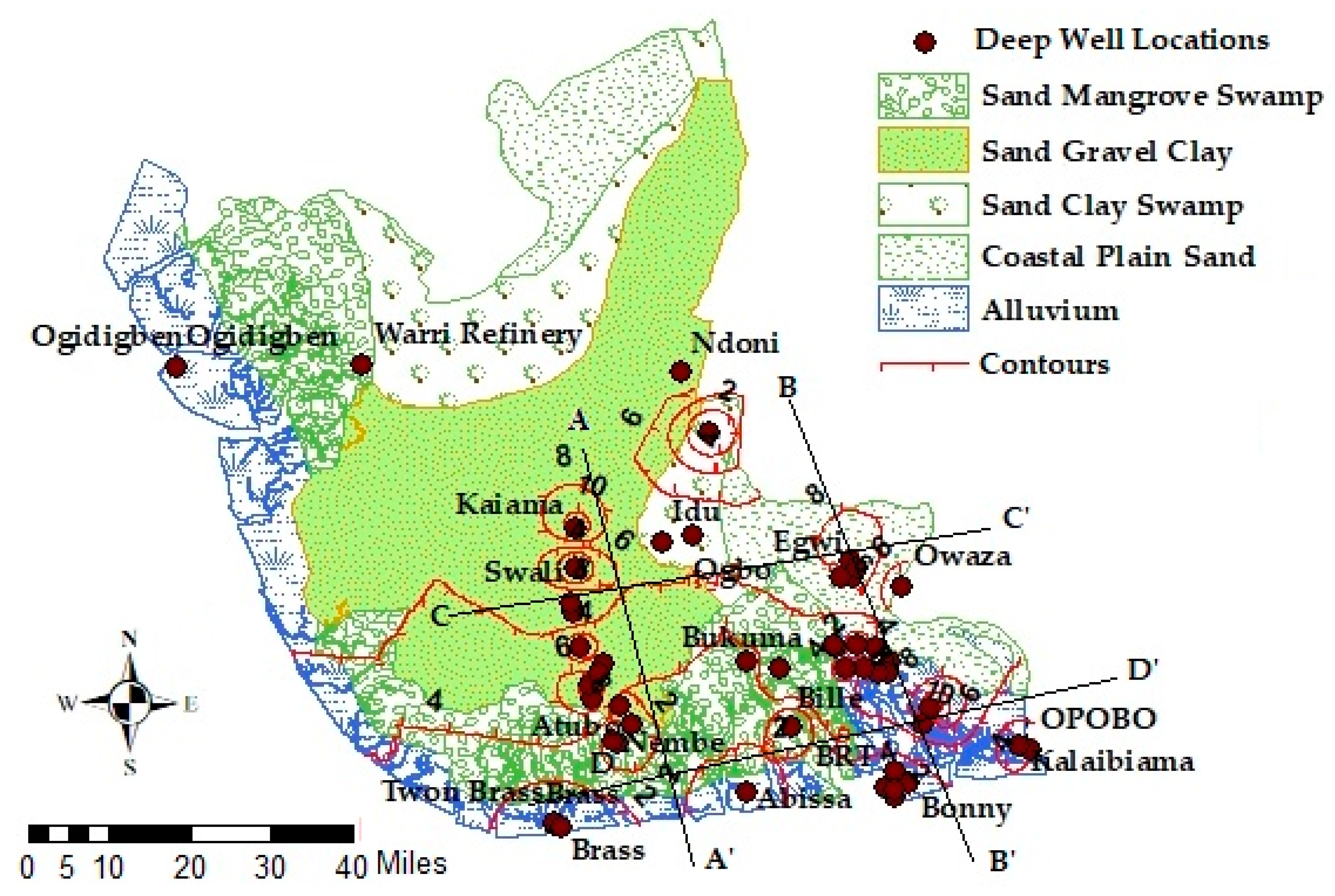
2.1. Description of the Study Area

The Niger Delta is an Eocene sedimentary basin that lies between latitude 4°40′ N to 5°40′ N and longitude 6°50′ E to 7°50′ E located in the southern part of Nigeria (Figure 1) and is situated in the Gulf of Guinea and extends into the central South Atlantic Ocean at the mouths of the Niger Benue and Cross River systems [21]. The basin is divided into three sub-regions, namely, the Western Niger Delta, the Central Niger Delta and the Eastern Niger Delta. The Central Niger Delta consists of the central section of the South-South coast of Nigeria, which includes Bayelsa and Rivers State, and the Eastern Niger Delta consists of Cross River State and Akwa Ibom State. The area has a humid subequatorial climate with a short dry season from November to February and a long wet season from March to October. The annual average temperature is 27 °C, with a small range of 3 °C. The annual rainfall ranges from 2000 mm in the north to more than 4000 mm in the coastal areas, with an average of 3000 mm [22].
The area is characterized by two main physiographic zones: the hilly region to the north and coastal plains to the south. These isolated hilly regions show a complicated surface relief that is separated into two main parts by the Niger River. The elevation of the area ranges from −5 m masl towards the sea in the south to 400 m in the northern part. The coastal plain is generally flat, but local sand bars give it a gently undulating view [22].

2.2. Geology of the Area

The Niger Delta is one of the significant regressive deltaic sequences in the world. The delta is over 12 km thick and occupies an area of 75,000 km2 in the Gulf of Guinea. The Niger Delta basin is underlain by three formations, which include the Benin, Agbada and Akata Formations. The Benin Formation belongs to the Pliocene-Pleistocene age [23].
The Deltaic Formation and Benin Formation are the most critical groundwater aquifer formations in the Niger Delta [24,25,26,27]. In the Deltaic Formations, late Pleistocene to Holocene age sediments occupy most of the area of the present delta and stretch eastwards along the coastline. The Deltaic Plains (upper and lower) consist of coarse-to-medium-grained unconsolidated sands. These sands form lenticular beds with intercalations of peaty matter and lenses of soft, silty clay and shales. Gravelly beds, up to 10 m thick, have been reported here [28]. The Benin Formation outcrop is located in the north-east of the coastal belt and dips at a low angle in the south-west. The sediments here consist, generally, of unconsolidated lenticular and predominantly sandy formations with massive gravel and pebble beds giving rise to high-yielding boreholes [29]. The thickness of the outcrop is estimated at 2300 m [30]. To complete the stratigraphic sequence, it is important to include the Agbada Formation and the Akata Formation which are geologically older formations. The Agbada Formation consists of interbedded sands and marine shales, reported to range in depth from about 300 to 5000 m while the Akata Formation underlies the Agbada Formation and has a sequence of similar marine shales and clays with a range in depth of about 700 to 7000 m. Table 1 shows the summary of the stratigraphic units of the Niger Delta basin.

2.3. Hydrogeology

The Niger Delta is a sedimentary basin where groundwater recharge is mostly through infiltration and from precipitation and rivers/lagoons at the surface. The most significant aquifers in the Niger Delta are the Deltaic and Benin Formations. Most of the boreholes in the northern parts of the basin have tapped water from these unconfined aquifers. The geological sequence derived from the existing boreholes through logging revealed deep sandy units at a different part of the area, although some unconfined aquifers with artesian groundwater flow occured in some locations too [27]. The aquifers were therefore is classified into unconfined and confined.
Unconfined aquifers. The deltaic aquifer is classified as unconfined, which is the first and topmost groundwater unit recharged directly by infiltration from precipitation and baseflow. The water table in the Niger Delta area is very close to the ground surface, ranging from 0 to 9 m below ground level. This area experiences limited water table fluctuation due to heavy rainfall which varies from about 2400 mm a year inland to 4800 mm near the coast although some proportion of the rainfall is lost through runoff and evapotranspiration. As stated in [32], the Deltaic Plains have specific capacities ranging from 160 to 320 m3/d/m.
The Benin Formation is more permeable than the Deltaic Plains due to the nature of the sediments with a specific capacity ranging between 150 and 1400 m3/d/m [32]. The depth to the water table ranges between 3 and 15 m below the ground surface. A few values for seasonal fluctuations obtained from the area indicated seasonal differences in static water level fall between 2.1 and 3.6 m.
Confined aquifers. This type of aquifer occurs across the Deltaic Formation and the Benin Formation. Moderately high-yielding artesian flows characterise these formations. In some areas, the aquifers are confined by a clay bed up to 36 m thick [27]. The depth of the aquifers below this bed is approximately 100 m. Hydrogeological information indicates a hydrological connection between the confined aquifers along the coastline and the unconfined aquifers of the Benin Formation to the north. The aquifers increase in thickness towards the continent, while the confining clays thin out. The specific capacity for this formation varies from 90 to 320 m3/d/m. In the area underlain by the Benin Formation, the confined aquifers occur in the south eastern part of the Niger Delta. Several clay beds confine the aquifers. The confined aquifers consist mainly of very-coarse-to-medium-grained sands. The specific capacity for this formation varies between 140 and 180 m3/d/m.

3. Methodology

Borehole logs data were collected from 52 wells (Figure 2) in strategic locations (Table 2) across the Niger Delta basin from the Nigeria Hydrological Services Agency (NHISA). These wells were reported to be drilled using the rotary drilling method commonly used in the Niger Delta. Drilling was followed up with down-hole geophysical logging in addition to the pre-drilling surface geophysical survey. Most of the logging in this study was done using the Mount Sopris Instrument, MGS II Logger that has the ability to run a suite of logs which provide accurate qualitative and quantitative information.
The wells studied range in depth from 100 to 600 m and represent the middle and deeper aquifer systems of the Niger Delta. Their completion diameter ranges from 150 to 340 mm. The lining of the wells was mild steel casings adapted, at the intake region, to a sequence of stainless-steel screens of various diameters and lengths depending on the aquifer thickness and the budget of the water project. All the wells were gravel-packed and developed for optimum yield for domestic and industrial purposes. This data was used to construct cross-sections and fence diagrams from which conceptual aquifer geometry and characterisation was developed.
The lithological information from boreholes was converted into geologically homogeneous hydrogeological units, which might not be isotropic but have unique hydrodynamic properties [34]. The hydrogeological units definition was used to correlate those data points with the lithofacies description and other less precise descriptions. Elevations of the top and the bottom of the units are referred to as meters above sea level (masl).
The top and bottom elevations of the aquifer units were modelled using geographical information systems (GIS) tools (ArcGIS and ArcScene). The information produced by GIS was then exported to other software to perform different hydrogeological analyses and three-dimensional surface mapping. As sub-surface modelling are not free of uncertainty [35,36,37,38], both the geological knowledge of the study area and the application of cross-sections to the model allowed for considerable reduction in the degree of uncertainty in this work.

4. Results and Discussion

4.1. Aquifer Characterisation Using Borehole Logs

Aquifer characterisation is critical to groundwater resilience, which is essential to sustainable groundwater resource management. In this study, borehole logs data were collected from 52 wells in strategic locations (Table 2) across the Niger Delta basin. This data was used to construct cross-sections and fence diagrams from which aquifer geometry and characterisation was derived.

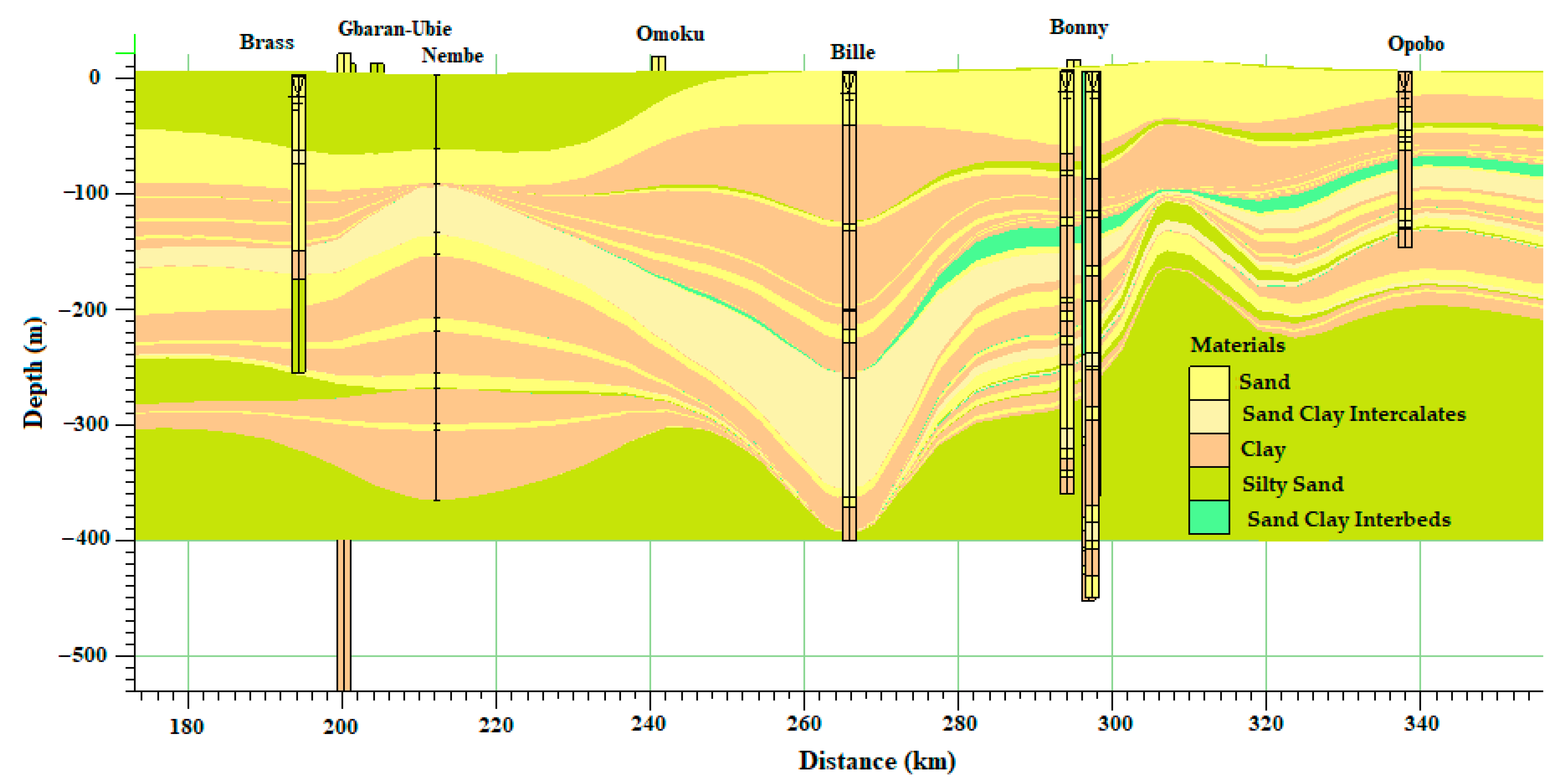
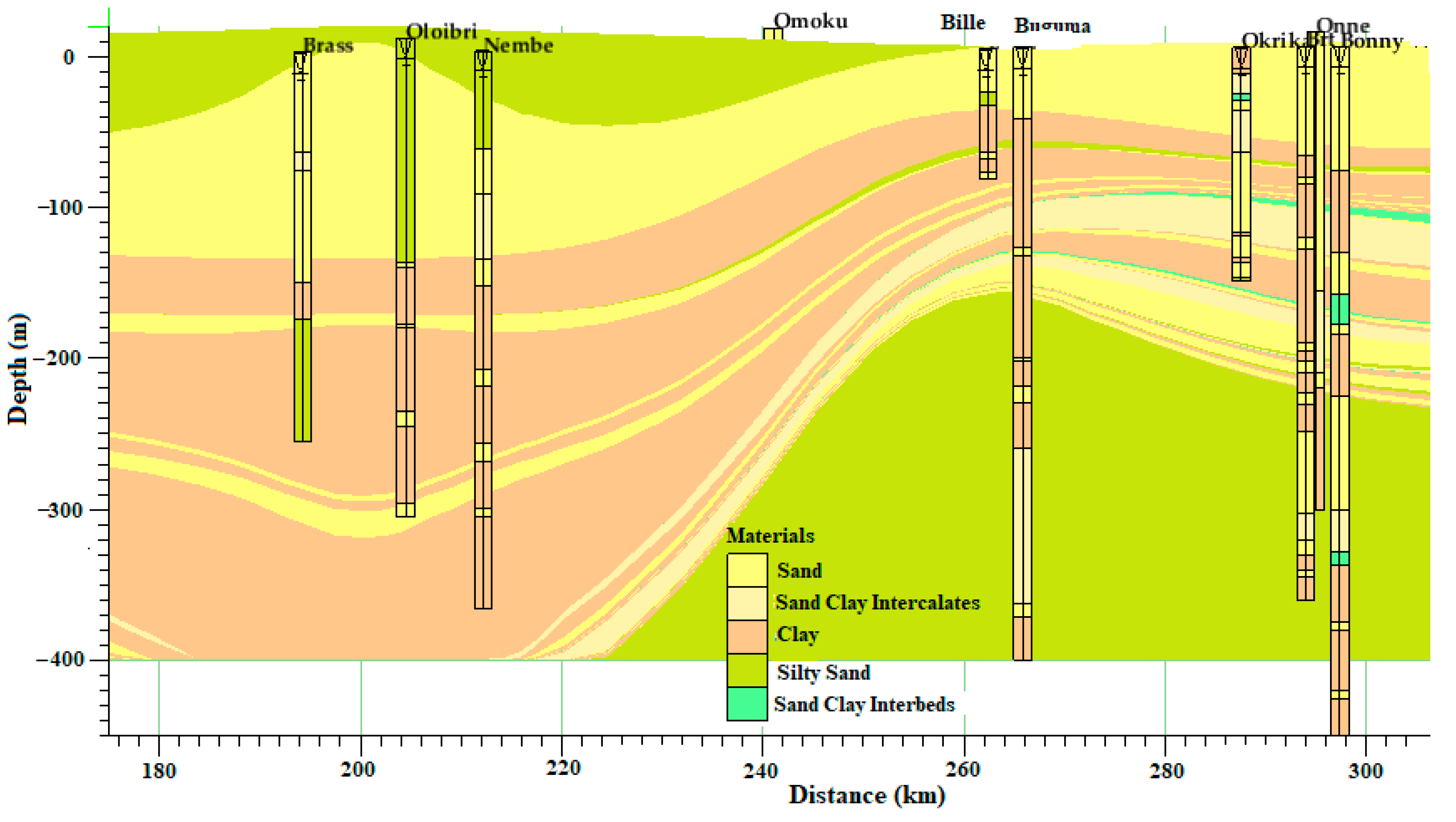
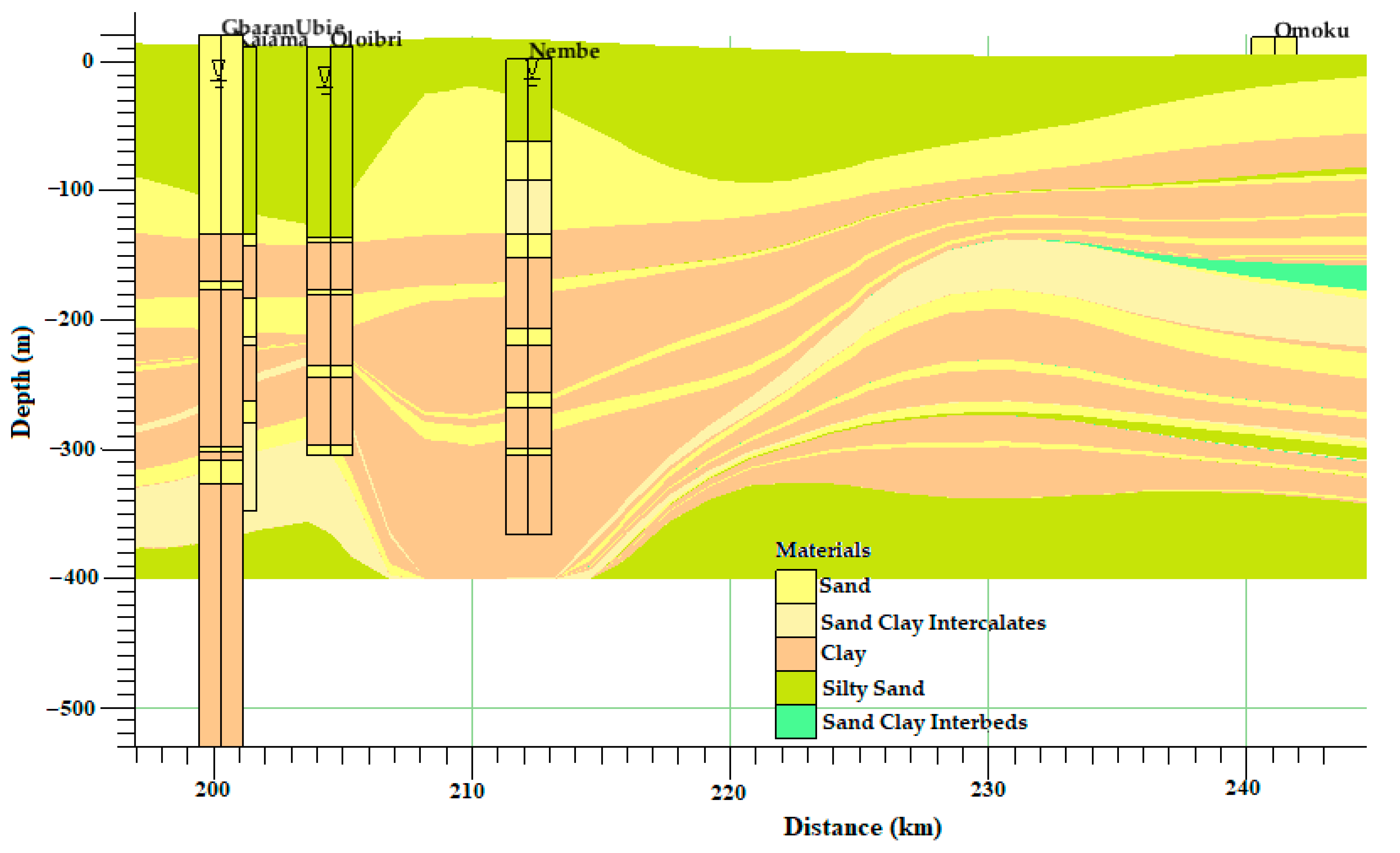
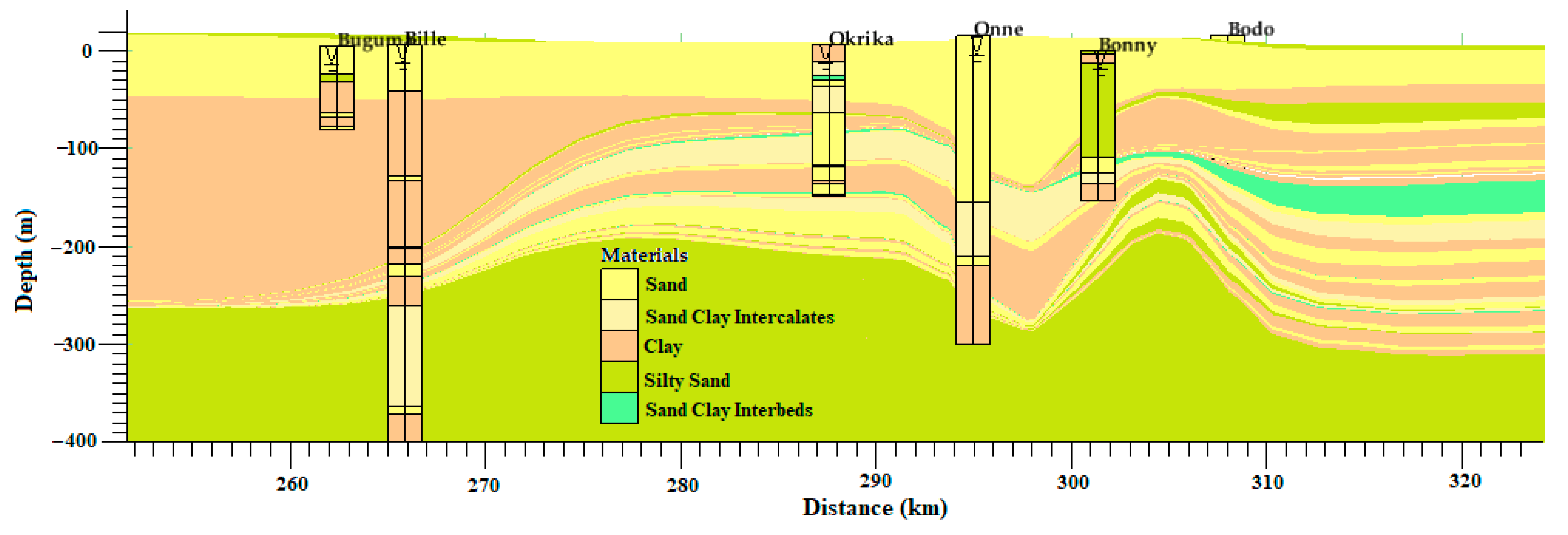
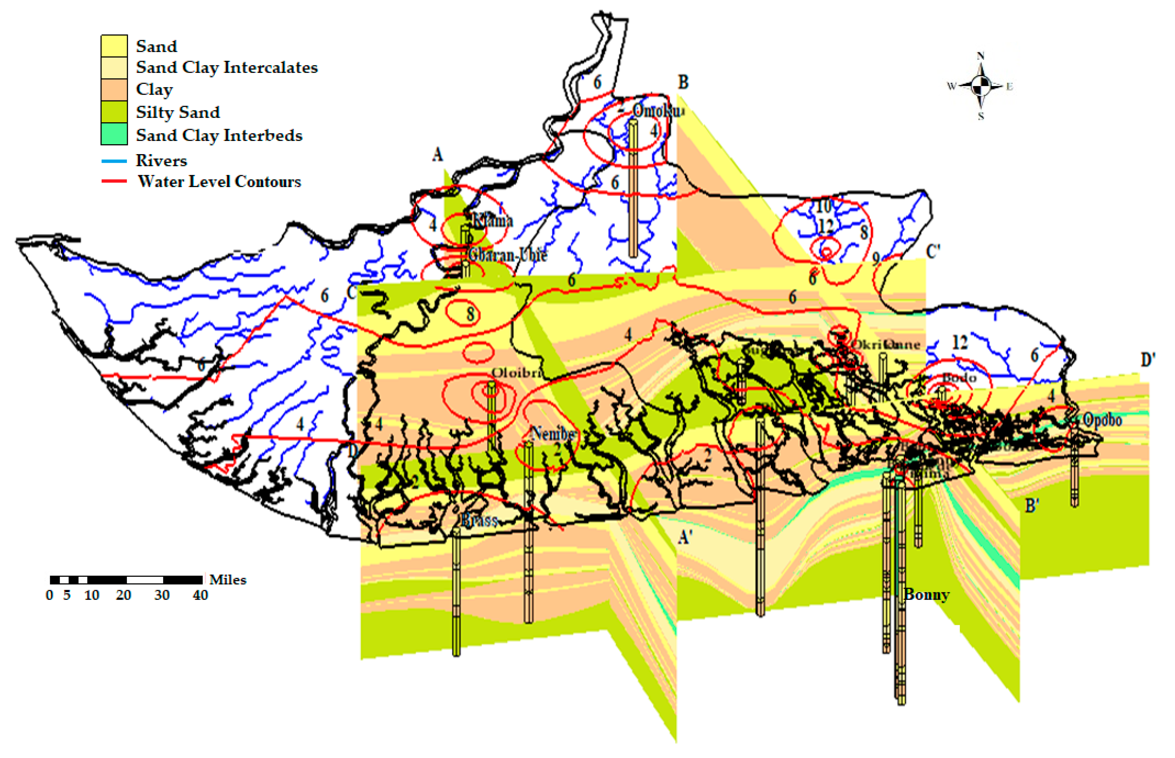
4.2. Cross-Sections from the Selected Boreholes

Four cross-sections (AAI, BBI, CCI and DDI) were generated from the results of the borehole logging. AAI and BBI are parallel in the SE-NW direction and perpendicular to CCI and DDI which are in the SW-SE direction though with a different number of the boreholes in each section depending on the nature of the terrain, land use and settlement. Cross-section AAI (Figure 3), with orientation SE-NW, contains boreholes from Kaiama, Gbaran-Ubie, Oloibiri, Nembe and Brass with respective depths of 348, 530, 280, 195 and 192 m while their respective static water levels remain at 3, 4.37, 2.4, 2.1 and 0.69 m below the ground level.
Cross-section BBI (Figure 4), with orientation SE-NW, comprises boreholes from Omoku, Buguma, Bille, Onne, Okrika, Bonny, Bodo Bonny, Opobo and Finima with respective depths of 183, 81, 193, 264, 149, 153, 153, 147 and 450 m while their respective static water levels remain at 0.68, 1.25, 0.6, 7.46, 11.4, 3.0, 6.1, 1.6 and 2.0 m below the ground level. Cross-section CCI (Figure 5), with orientation SE-NW, comprises boreholes from Gbaran-Ubie, Kaiama and Omoku with the respective depths of 520, 348 and 183 m while their respective static water levels remain at 4.37, 3.0 and 0.68 m below the ground level.
Cross-section DDI (Figure 6), with orientation SE-NW, comprises boreholes from Brass, Oloibiri, Nembe, Bille, Okrika, Bonny, Bodo, Onne and Opobo with respective depths of 192, 280, 195, 193, 149, 153, 153, 264 and 147 m while their respective static water levels remain at 4.37, 3.0 and 0.68 m below the ground level.
The lithologic logs show that the sand bodies are predominant in the northern part of the study area. These sand bodies begin to give way to distinct clay interbeds at the middle and towards the southeast of the study area. Around Obigbo, through Akpajo and Buguma to Nembe, the number of distinct clay interbeds increases from 3 at Obigbo to 5 at Akpajo and Buguma and to 11 at Nembe. While the northern part (Figure 3) contains one or two thick aquifers, the increased number of clay layers in the central part has partitioned the aquifers into 3 to 5 thinner units (Figure 5). The more frequent alternation of sand and clay layers in the south and towards the coast has resulted in a greater number of aquifers in the southern part (Figure 6). However, the greater the number of aquifer lenses, the less their thicknesses tends to be.
In all these areas, there are unconfined aquifers with unconsolidated fine-to-medium-grain sands with a depth range from 1 to 45 m depending on location. A low permeable aquitard underlies these with clay, shale, peat and some organic materials with a little fraction of sands in some locations and a thickness ranging from 8 to 45 m. The thickness of the second aquifer ranges from 10 to 35 m while the third aquifer is about 10–35 m with a depth ranging from 150 to 240 m thick. The fourth aquifer starts from 200 to 250 m depending on the locations. The groundwater resources are within the alluvium and coastal plain sands of the deltaic formation of the Niger Delta basin. The boreholes around the area tap three main aquifer units. The unconfined aquifer with water levels ranging from 0 to 25 m, and 2–3 confined units ranging from 35 to 48 m, 45 to 65 m and 55 to 102 m. The aquifers are of fine-to-medium-grain sands with clay and shale layers acting as separating layers between them due to their low permeability.

4.3. Hydraulic Characterisation of the Aquifers

Hydraulic conductivity data presented in this report were extracted from previous studies at different periods across the Niger Delta basin (Table 3). The value of hydraulic conductivity shows high variability in the alluvium and coastal plain sand formations, which could be a result of an active and complex depositional process of the region.
Hydraulic conductivity (K) data of the study area aquifers was revealed to be 3.9 × 10⁻⁴ to 4.1 × 10⁻⁴ m/s [39], 1.2 to 3.53 × 10⁻⁴ m/s [40], 2.8 × 10⁻⁷–6.3 × 10⁻⁴ m/s [41] and 2.8 × 10⁻⁷–6.3 × 10⁻⁴ m/s [41] within the Benin Formation, and 4.2 × 10⁻⁴ to 4.1 × 10⁴ m/s [42], 7.0 × 10⁻⁵–1.0 × 10⁻⁴ m/s [32] and 2.01 × 10⁻⁵–5.0 × 10⁻⁵ m/s [43] within the Deltaic/Alluvium Formation. A recent study [44] revealed the hydraulic conductivity (K) values for boreholes located in the Port-Harcourt township at Churchill Road (3.24 × 10⁻³cm/sec); Borokiri Sand fill (3.62 × 10⁻³ cm/sec); Marine Base (9.61 × 10⁻³ cm/sec); Aggrey Road (8.41 × 10⁻³ cm/sec); Reclamation Road (2.2 × 10⁻³ cm/sec); and Harold Wilson Drive (4.0 × 10⁻³ cm/sec). Virtually all the boreholes in these areas terminate within the coastal plain sand of the Benin formation. These layers are depicted in the stratigraphic sections.

4.4. Implications for Groundwater Resilience in Shallow Aquifers of the Niger Delta Basin

Hydraulic characterisation shows a thin to a thick layer of silty sand from the Deltaic Formation, which renders little or partial protection for the groundwater stored in the sandy aquifer that is semi-confined at locations in the western part of the study area around Kiama, Gbaran-Ubie, Nembe and Baras (Figure 4). This layer thins out towards the middle of the area around Buguma and Bille, towards the eastern part of the area, leaving the sandy aquifer completely unconfined as presented in Figure 7. Results of hydraulic conductivity show higher values in the Benin Formation compared to the Deltaic/Alluvium Formation (Table 3), which could be attributed to the nature and types of the dominant sediments. There are more shallow, confined aquifers at the southern part of the basin but most of which are thin, hence a low groundwater potential based on their storage capacity.
Deeper wells in these areas have been reported by [47,48] to have higher salinity due to saltwater intrusion. The eastern part of this area, which comprises Okrika, Bodo, Bonny, Finima, Opbo and Buguma, has a thick, sandy, unconfined aquifer with higher static water (Figure 7) which makes it vulnerable to pollution and contamination from the surface water. Deeper boreholes/wells that are designed to tap multiple thin layers of the sandy aquifer are the source of fresh potable water. Generally, groundwater in the unconfined aquifers of the Niger Delta basin could be described as having low resilience due to the nature of the sediments (hydraulic characteristics) and the number of drivers from natural (climate change, flooding, saltwater intrusion) to anthropogenic (oil spillage, gas flaring, industrial, municipal and agricultural effluents and leachates) pollution sources. There is a need for strategic studies that will include the recharge process of the aquifers, especially the unconfined aquifers in the area, for better assessment of the sustainable management of the groundwater resources of the basin.

5. Conclusions

The study has presented a comprehensive understanding of the hydrostratigraphy and hydraulic behaviour of the Niger Delta basin aquifer system. The study identified 2 to 4 groundwater aquifer layers with some unconfined aquifers with unconsolidated fine-to-medium-grain sands and depth range of 1–45 m based on locations. A low permeable aquitard underlies these with clay, shale, peat and some organic materials with a little fraction of sands in some locations with a thickness ranging from 8 to 45 m. The thickness of the second aquifer ranged from 10 to 35 m while the third aquifer was about 10–35 m with a depth ranging from 150 to 240 m thick. The fourth aquifer started from 200 to 250 m depending on the location. The groundwater resources are within the alluvium and coastal plain sands of the Deltaic Formation of basin. Hence, examination of the borehole depth showed that all of the 52 boreholes terminated in the coastal plain sands with relatively higher hydraulic conductivity values. The higher hydraulic conductivity values coupled with higher static water level indicates high vulnerability to contaminants and pollution, which are a threat to the groundwater resilience of the Niger Delta basin. The study provided a framework on which numerical model design can be undertaken to form a complete conceptual groundwater flow model of the basin. The study has also provided vital information for water resource managers and other stakeholders in the water industry to make better decisions for the sustainable management of groundwater resources.

Author Contributions

I.H. and R.M.K. designed the research; I.H. wrote the original draft.; R.M.K., C.J.W. and J.A.A. reviewed and edited the manuscript and provided technical help and proposed important additions with the model and to the manuscript.; R.M.K. gave critical views on the manuscript for further improvement.

Funding

This research was funded by the Petroleum Technology and Development Fund (PTDF) under the Overseas PhD scholarship scheme and supported by the Scottish Government under the Climate Justice Fund Water Futures Programme, awarded to the University of Strathclyde (R.M. Kalin).

Acknowledgments

The authors would like to gratefully acknowledge H.O. Nwankwoala and the Nigerian Hydrological Service Agency (NHISA) for providing the data used in this study.

Conflicts of Interest

The authors declare no conflict of interest.

References

  1. Hutton, G.; Chase, C. The Knowledge Base for Achieving the Sustainable Development Goal Targets on Water Supply, Sanitation and Hygiene. Environ. Res. Public Heal. 2016, 13, 536. [Google Scholar] [CrossRef] [PubMed]
  2. Cosgrove, W.J.; Loucks, D.P. Water Management: Current and Future Challenges and Research Directions. Water Resour. Res. 2015, 51, 4823–4839. [Google Scholar] [CrossRef]
  3. Hydrogeology, Ground-Water Quality, and Sources of Nitrate in Lowland Glacial Aquifers of Whatcom County, Washington, and British Columbia, Canada. Available online: https://pubs.er.usgs.gov/publication/wri984195 (accessed on 6 November 2019).
  4. Taylor, R.G.; Scanlon, B.; Döll, P.; Rodell, M.; Van Beek, R.; Wada, Y.; Longuevergne, L.; Leblanc, M.; Famiglietti, J.S.; Edmunds, M.; et al. Ground water and climate change. Nat. Clim. Chang. 2012, 3, 322–329. [Google Scholar] [CrossRef] [Green Version]
  5. Edet, A.; Abdelaziz, R.; Merkel, B.; Okereke, C.; Nganje, T. Numerical Groundwater Flow Modeling of the Coastal Plain Sand Aquifer, Akwa Ibom State, SE Nigeria. J. Water Resour. Prot. 2014, 6, 193–201. [Google Scholar] [CrossRef] [Green Version]
  6. Niger Delta Human Development Report: United Nations Development Programme. Available online: https://www.google.com.hk/url?sa=t&rct=j&q=&esrc=s&source=web&cd=11&ved=2ahUKEwjZ-c7Pz9TlAhURGqYKHT7eCG8QFjAKegQIAhAC&url=http%3A%2F%2Fwww.bebor.org%2Fwp-content%2Fuploads%2F2012%2F09%2FUNDP-Niger-Delta-Human-Development-Report.pdf&usg=AOvVaw3elgWLtLf575CEf7eh6gQL (accessed on 6 November 2019).
  7. Nnabuenyi, U.M. Impact of Oil Exploration and Exploitation on the Niger Delta Region: Environmental Perspective. Niger. J. Sci. Environ. 2012, 11. [Google Scholar]
  8. Gordon, A.; Obenade, M. Flood Vulnerability Assessment of Niger Delta States Relative to 2012 Flood Disaster in Nigeria. Am. J. Environ. Prot. 2015, 3, 76–83. [Google Scholar]
  9. Gordon, A.; Gobo, A.E. Factors That Influence the Flooding of the Middle and Lower Ntamogba Stream Catchments, Port Harcourt, Nigeria. J. Environ. Hydrol. 2007, 15, 1–11. [Google Scholar]
  10. Ologunorisa, T.E.; Adeyemo, A. Public Perception of Flood Hazard in the Niger Delta, Nigeria. Environmentalist 2005, 25, 39–45. [Google Scholar] [CrossRef]
  11. Mmom, P.C.M.P.C. Vulnerability and Resilience of Niger Delta Coastal Communities to Flooding. IOSR J. Humanit. Soc. Sci. 2013, 10, 27–33. [Google Scholar] [CrossRef]
  12. Godleads, A.; Prekeyi, T.-F.; Megbuwe, P. Some Aspects of a Historic Flooding in Nigeria and Its Effects on Some Niger-Delta Communities. Am. J. Water Resour. 2015, 3, 7–16. [Google Scholar]
  13. Charles, M.; Noyes Maley, M.P.; Blake, R.G. Defining Hydrostratigraphic Units within the Heterogeneous Alluvial Sediments at Lawrence Livermore National Laboratory. Presented at Cordilleran Section-97th Annual Meeting, and Pacific Section, American Association of Petroleum Geologists, Universal City, CA, USA, 9–11 April 2001; p. 39. [Google Scholar]
  14. Sanz, D.; Gómez-Alday, J.J.; Castaño, S.; Moratalla, A.; Heras, J.D.L.; Martínez-Alfaro, P.E. Hydrostratigraphic framework and hydrogeological behaviour of the Mancha Oriental System (SE Spain). Hydrogeol. J. 2009, 17, 1375–1391. [Google Scholar] [CrossRef]
  15. Diana, M.A.; Nadine, S.; Aparna, D.; Jacek, S. Data Integration and Standardization in Cross-Border Hydrogeological Studies: A Novel Approach to Hydrostratigraphic Model Development. Environ. Geol. 2008, 53, 1441–1453. [Google Scholar]
  16. Asfahani, J. Hydraulic parameters estimation by using an approach based on vertical electrical soundings (VES) in the semi-arid Khanasser valley region, Syria. J. Afr. Earth Sci. 2016, 117, 196–206. [Google Scholar] [CrossRef]
  17. Farid, A.; Jadoon, K.; Akhter, G.; Iqbal, M.A. Hydrostratigraphy and Hydrogeology of the Western Part of Maira Area, Khyber Pakhtunkhwa, Pakistan: A Case Study by Using Electrical Resistivity. Springer Environ. Monit. Assess. 2013, 185, 2407–2422. [Google Scholar] [CrossRef]
  18. Adepelumi, A.A.; Ako, B.D.; Ajayi, T.R.; Afolabi, O.; Omotoso, E.J. Delineation of Saltwater Intrusion into the Freshwater Aquifer of Lekki Peninsula, Lagos, Nigeria. Environ. Geol. 2009, 56, 927–933. [Google Scholar] [CrossRef]
  19. Oyedele, K.F.; Ayolabi, E.A.; Adeoti, L.; Adegbola, R.B. Geophysical and hydrogeological evaluation of rising groundwater level in the coastal areas of Lagos, Nigeria. Bull. Int. Assoc. Eng. Geol. 2009, 68, 137–143. [Google Scholar] [CrossRef]
  20. Raji, W.O.; Obadare, I.G.; Odukoya, M.A.; Johnson, L.M. Electrical resistivity mapping of oil spills in a coastal environment of Lagos, Nigeria. Arab. J. Geosci. 2018, 11, 144. [Google Scholar] [CrossRef]
  21. Aturamu, A.O.; Ojo, A.O.; Adebayo, O.F.; Akinyemi, S.A. Palynostratigraphic Analysis of the Agbada Formation (Nep-1 Well) Offshore, Eastern Niger-Delta Basin, Nigeria. Br. J. Environ. Sci. Cent. 2015, 3, 19–31. [Google Scholar]
  22. Ophori, D.U. A simulation of large-scale groundwater flow in the Niger Delta, Nigeria. Environ. Geosci. 2007, 14, 181–195. [Google Scholar] [CrossRef]
  23. Owoyemi, A.O.D. The Sequence Stratigraphy of Niger Delta, Delta Field, Offshore Nigeria. Master’s Thesis, Texas A&M University, College Station, TX, USA, August 2004. [Google Scholar]
  24. Nwankwoala, H. Hydrogeology And Groundwater Resources Of Nigeria. N. Y. Sci. J. 2015, 8, 89–100. [Google Scholar]
  25. Okeke, O.C.; Onyekuru, S.O.; Uduehi, G.; Israel, H.O. Geology and Hydrogeology of Northern Ishan District, Edo State, Southwestern Nigeria. Int. Res. J. Geol. Min. 2011, 1, 1–11. [Google Scholar]
  26. Matthew, E.O. Hydrogeology: Groundwater Study and Development in Nigeria, Third Edit; Mecon Geology & Engineering Services Ltd.: Jos, Nigeria, 2014. [Google Scholar]
  27. Adelana, S.; Olasehinde, P.; Bale, R.; Vrbka, P.; Edet, A.; Goñi, I. An overview of the geology and hydrogeology of Nigeria. In Applied Groundwater Studies in Africa; Segun, A., Alan, M., Eds.; CRC Press: London, UK, 2008. [Google Scholar]
  28. Et, U.; Je, E. Comparison of the Characteristics of Low Velocity Layer (LVL) in the Mangrove Swamp and in the Upper Flood Plain Environments in the Niger Delta, using Seismic Refraction Methods. J. Geol. Geophys. 2016, 5. [Google Scholar] [CrossRef] [Green Version]
  29. Ugwu, S.A.; Nwankwoala, H.O. Application of seismic refraction methods in groundwater studies in Calabar Southeastern Nigeria. Sci. Afr. 2008, 7, 73–80. [Google Scholar] [CrossRef]
  30. Nwankwoala, H.O.; Amadi, A.N.; Ushie, F.A.; Warmate, T.A.; Eze, C.J. Determination of Subsurface Geotechnical Properties for Foundation Design and Construction in Akenfa Community, Bayelsa State, Nigeria. Am. J. Civ. Eng. Archit. 2014, 2, 130–135. [Google Scholar] [CrossRef] [Green Version]
  31. Nwankwoala, H.O.; Ngah, S.A. Groundwater Resources of the Niger Delta: Quality Implications and Management Considerations. Int. J. Water Resour. Environ. Eng. 2014, 6, 155–163. [Google Scholar]
  32. Offodile, M.E. An Approach to Groundwater Study and Development in Nigeria; MECON Geology and Engineering Services Ltd.: Jos, Nigeria, 1992. [Google Scholar]
  33. NGSA. Geological Maps of Nigeria-Nigerian Geological Survey Agency. 2012. Available online: https://ngsa.gov.ng/GeoMaps (accessed on 6 Novmber 2019).
  34. Mary, P.A.; William, W.W.; Randall, J.H. (Eds.) Applied Groundwater Modeling, Second Edition: Simulation of Flow and Advective Transport; Elsevier: Amsterdam, The Netherlands, 2015. [Google Scholar]
  35. Nilsson, B.; Højberg, A.L.; Refsgaard, J.C.; Troldborg, L. Uncertainty in Geological and Hydrogeological Data. Hydrol. Earth Syst. Sci. 2007, 3, 2675–2706. [Google Scholar]
  36. Gerard, B.M.H.; Peter, A.B.; Alfred, S. Propagation of Error in Spatial Modelling with GIS. Int. J. Geogr. Inf. Syst. 1989, 4, 303–322. [Google Scholar]
  37. Jichun, W.; Xiankui, Z. Review of the uncertainty analysis of groundwater numerical simulation. Chinese Sci. Bull. 2013, 58, 3044–3052. [Google Scholar] [Green Version]
  38. Rojas, R.; Feyen, L.; Dassargues, A. Conceptual model uncertainty in groundwater modeling: Combining generalized likelihood uncertainty estimation and Bayesian model averaging. Water Resour. Res. 2008, 44, 1–16. [Google Scholar] [CrossRef]
  39. Amajor, L.C. Geological Appraisal of Groundwater Exploitations in the Eastern Niger Delta. In Groundwater and Mineral Resources of Nigeria; Ofoegbu, C.O., Ed.; Springer: Berlin, Germany, 1989; pp. 85–100. [Google Scholar]
  40. Uma K, O. An Appraisal of the Groundwater Resources of the Imo River Basin, Nigeria. J. Min. Geol. 1989, 25, 305–331. [Google Scholar]
  41. Okagbue C., O. Geotechnical And Environmental Problems of the Niger Detla. Detla. Bull. Eng. Geol. Environ. 1989, 40, 119–126. [Google Scholar] [CrossRef]
  42. Etu-Efeotor, J.O.; Odigi, M.I. Water Supply Problems in the Eastern Niger Delta. J. Min. Geol. 1983, 20, 183–193. [Google Scholar]
  43. Izeze, I.A. Aquifer Characteristics of the Coastal Plain Sands of the Southern Nigeria. M.Sc. Thesis, University of Port Har-court, Port Harcourt, Nigeria, 1990. [Google Scholar]
  44. Nwankwoala, H. Aquifer Hydraulic Conductivity Determination from Grain Size Analysis in Parts of Old Port Harcourt Township, Nigeria. ARPN J. Sci. Technol. 2013, 3, 972–981. [Google Scholar]
  45. Onuoha, K.M.; Mbazi, F.C. Aquifer Transmissivity from Electrical Sounding Data: The Case of Ajali Sandstone Aquifers, Southeast of Enugu, Nigeria. In Groundwater and Mineral Resources of Nigeria; Ofoegbu, C.O., Ed.; Springer: Berlin, Germany, 1989. [Google Scholar]
  46. Nwankwoala, H.O.; Oborie, E.; Island, W.; State, B. Geo-Technical Investigation and Characterization of Sub-Soils in Yenagoa, Bayelsa State, Central Niger Delta, Nigeria. Civ. Environ. Res. 2014, 6, 234–240. [Google Scholar]
  47. Akomeno, U.O. Electric Logs for Groundwater Exploration in the Niger Delta. Chall. Afr. Hydrol. Water Resour. 1984, 144, 87–94. [Google Scholar]
  48. Akomeno, U.O.; Atolagbe, F.P. Saltwater Intrusion into Coastal Aquifers in Nigeria. In The Second International Conference on Saltwater Intrusion and Coastal Aquifers—Monitoring, Modeling, and Management. Mérida, Yucatán, México. Environments and the 1st Arab Water Forum; 2003; pp. 1–15. Available online: https://olemiss.edu/sciencenet/saltnet/swica2/Oteri_ext.pdf (accessed on 6 November 2019).
Figure 1. Digital elevation map showing the location of the study area in Nigeria.
Geosciences 09 00470 g001
Figure 2. Geology map (Adopted and Modified from [33]) of the study area showing cross-section lines along which lithosections are developed.
Geosciences 09 00470 g002
Figure 3. Hydrostratigraphic section along profile line AAI at various zones within the Niger Delta basin.
Geosciences 09 00470 g003
Figure 4. Hydrostratigraphic section along profile line BBI at various zones within the Niger Delta basin.
Geosciences 09 00470 g004
Figure 5. Hydrostratigraphic section along profile line CCI at various zones within the Niger Delta basin.
Geosciences 09 00470 g005
Figure 6. Hydrostratigraphic section along profile line DDI at various zones within the Niger Delta basin.
Geosciences 09 00470 g006
Figure 7. Fence diagram showing hydrostratigraphic section within the Niger Delta basin.
Geosciences 09 00470 g007
Table 1. Stratigraphic Units of the Niger Delta basin [31].
Outcropping UnitsSubsurface UnitsPresent-day Equivalents
Benin FormationBenin FormationContinental (fluviatile) deposits, mainly sandstones
Ogwashi–Asaba
Formation
Ameki Formation
Agbada FormationMixed continental brackish water and marine deposits, sandstones and clays
Imo ShalesAkata FormationMarine deposits, mainly clays
Table 2. Borehole locations with strata logs, their depths and static water levels.
S/No.Borehole LocationGeomorphic ZoneTotal Depth Drilled (m)Static Water Level (m)
1OgboCPS1867.0
2EdochaCPS1854.26
3Port Harcourt (Old GRA)CPS2075.5
4NdoniCPS1827.55
5IduCPS1856.2
6Ebubu CPS926.0
7AzikoroFWS3358.6
8SwaliFWS3358.8
9Finima (Life camp)CBR3601.3
10Onne (FOT) *CPS1906.0
11Finima (BRT)CBR3601.0
12BassambiriCBR2500.8
13AtuboSWS1931.37
14NembeSWS1952.1
15OgbiaFWS1982.5
16BrassCBR1920.69
17Twon BrassCBR2601.2
18Brass (NAOC Tank farm)CBR2560.8
19OtegilaFWS1854.0
20OkorobaFWS2250.0
21AmakalakalaFWS1609.14
22OtugidiFWS4260.91
23OtuesagaFWS10212.19
24OwazaCPS1523.6
25Kolo creekFWS1025.2
26Onne (NAFCON)CPS2647.49
27OtakemeFWS3004.2
28OmokuSWP1830.68
29Aleto ElemeCPS1507.75
30BukumaSWS1831.25
31Kala DegemaSWS1712.8
32AbissaSWS1470.4
33BilleSWS1930.6
34OpiroSWS13813
35RumonyeCPS18822
36ChokochoCPS13210
37EgwiCPS2018.25
38UmuechemCPS1325.5
39OkrikaSWS11311.4
40Ibuluya-DikiboSWS1808.2
41Bolo 1SWS925.5
42Abam AmaSWS128ARTESIAN
43OkujiaguSWS1100.7
44George AmaSWS2000.9
45KalaibiamaCBR3052.4
46BonnyCBR1983.0
47Bonny (Water Board)CBR4501.2
48Bonny (Oguede)CBR460ARTESIAN
49Okoloma (Afam)CPS1206.3
50Borokiri *SWS1902.5
51Gbaran-UbieFWS530-
52Ogidigben/UgorodoCBR600-
CPS = coastal plain sands, FWS = freshwater swamp, SWS = saltwater swamp, CBR = coastal beaches and ridges, SWP = Sambreiro Warri deltaic plain, * = transitional zone.
Table 3. Hydraulic conductivity values from different authors across the study area.
S/NAuthorHydraulic Conductivity RangeGeology
1Okagbue et al. [41]7.2 × 10⁻⁵–2.4 × 10⁻³m/sBenin Formation
2Amajor et al. [39]3.91 × 10⁻⁴–4.1 × 10⁻⁴m/sBenin Formation
3Uma et al. [40]1.2 to 3.53 × 10⁻⁴m/sBenin Formation
4Etu-Efeotor & Odigi [42]4.2 × 10⁻⁷–4.1 × 10⁻⁴Deltaic Formation
5Etu-Efeotor & Akpokodje [32]7.0 × 10⁻⁵–1.0 × 10⁻⁴ m/sDeltaic/Alluvium Formation
6Izeze et al. [43]2.01 × 10⁻⁵–5.0 × 10⁻⁵ m/sDeltaic/Alluvium Formation
7Okagbue et al. [41] 2.8 × 10⁻⁷–6.3 × 10⁻⁴ m/sBenin Formation (Ajali sandstone)
8Onuoha & Mbazi [45] 4.4 × 10⁻⁵–1.5 × 10⁻⁴ m/sBenin Formation (Ajali sandstone)
9Nwankwoala et al. [46]1.8 × 10⁻³–3.2 × 10⁻³m/sDeltaic/Alluvium Formation

