Subsidence Trends of Volturno River Coastal Plain (Northern Campania, Southern Italy) Inferred by SAR Interferometry Data


Abstract
1. Introduction
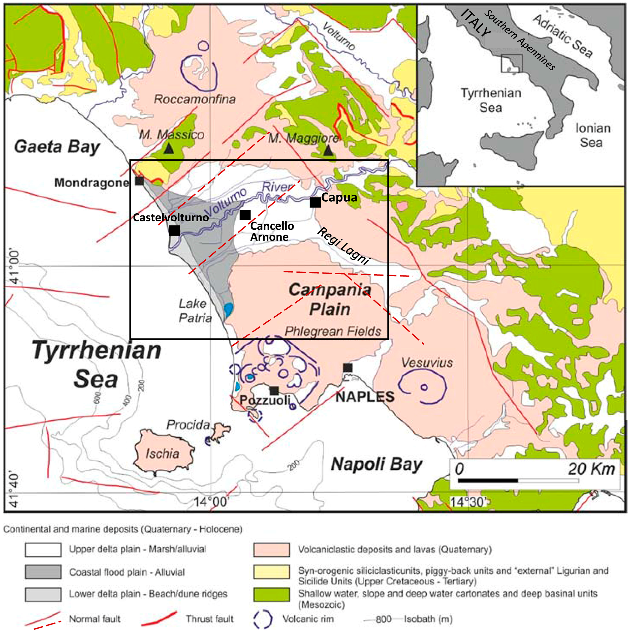
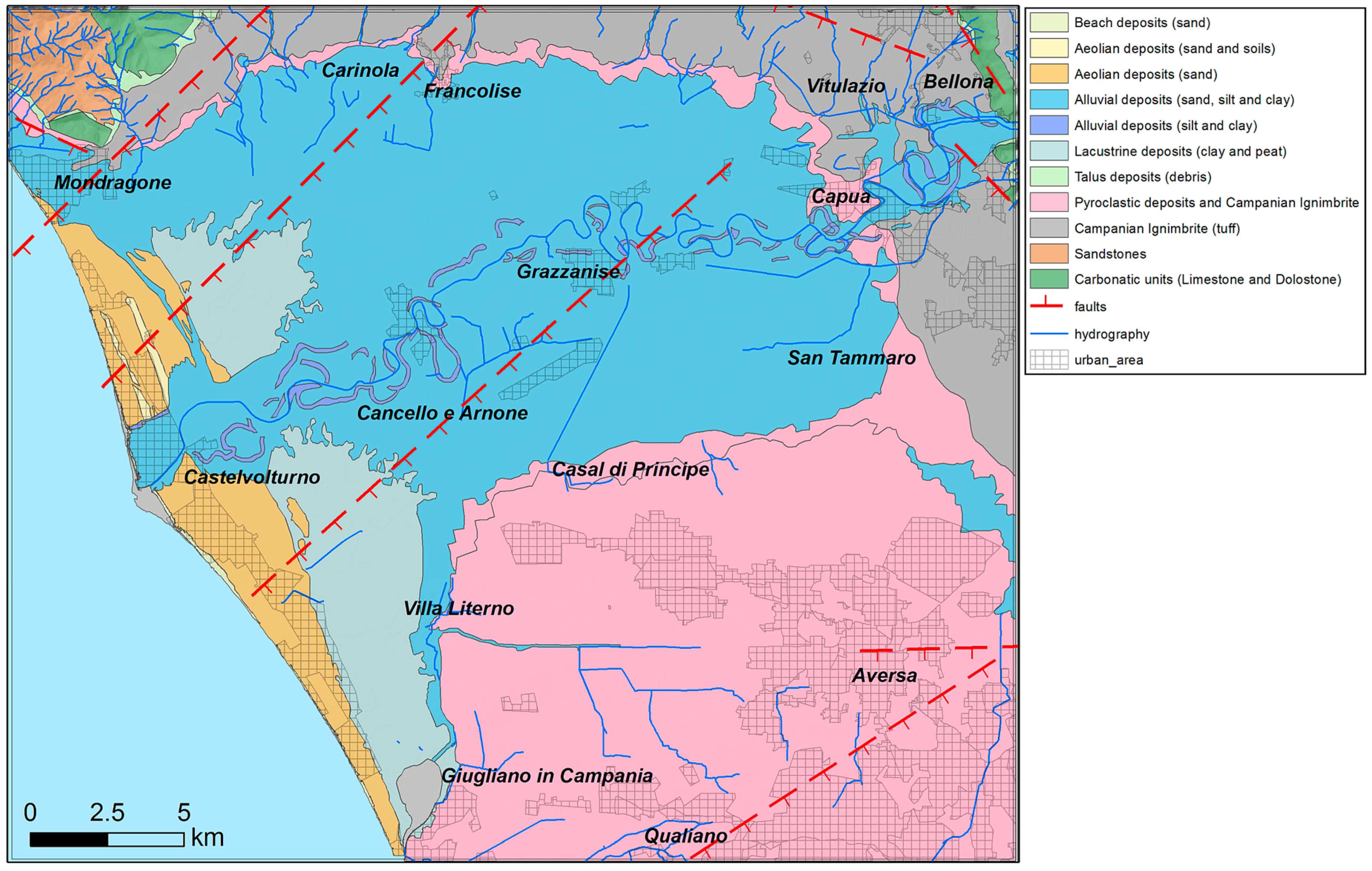
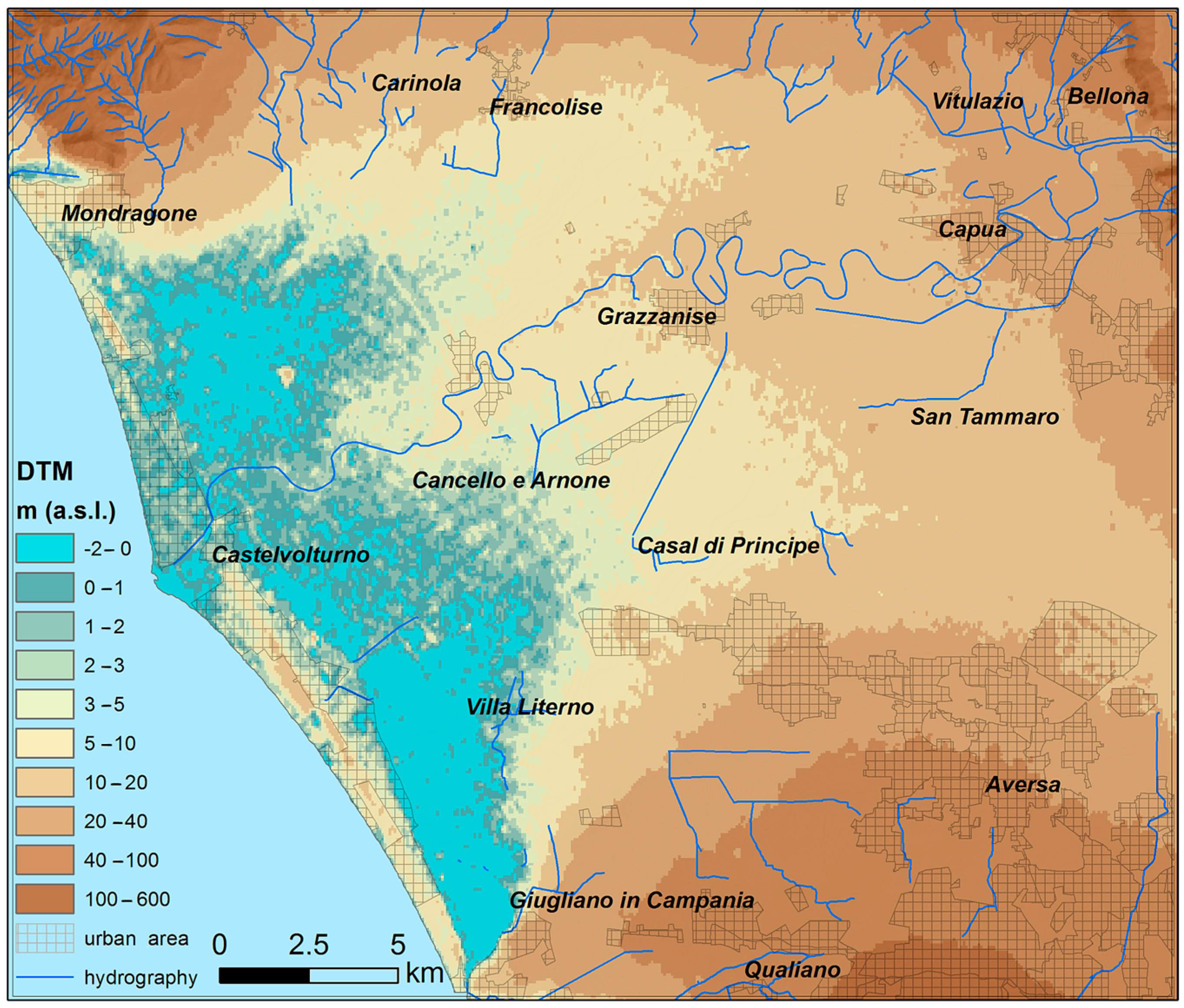
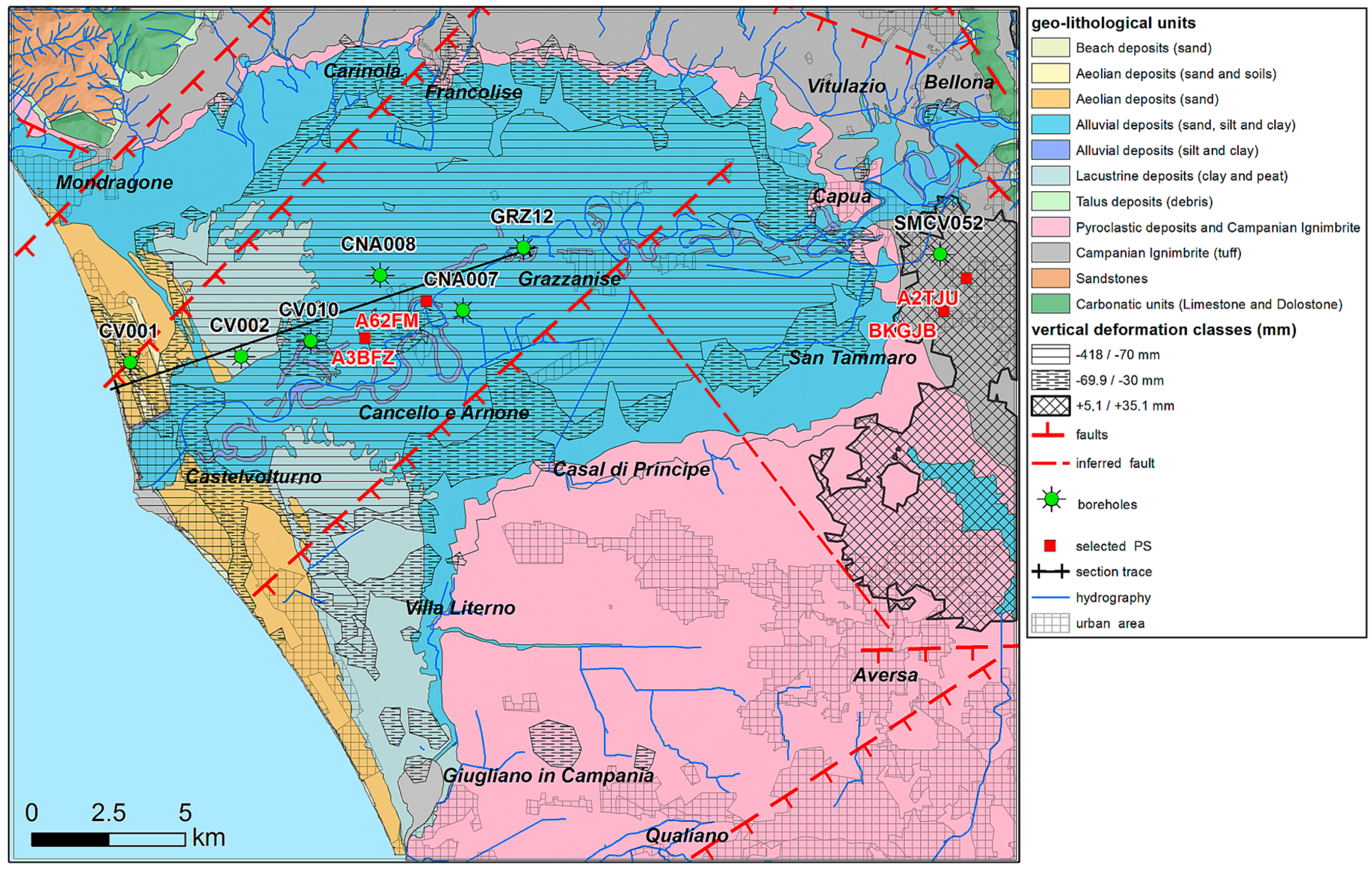
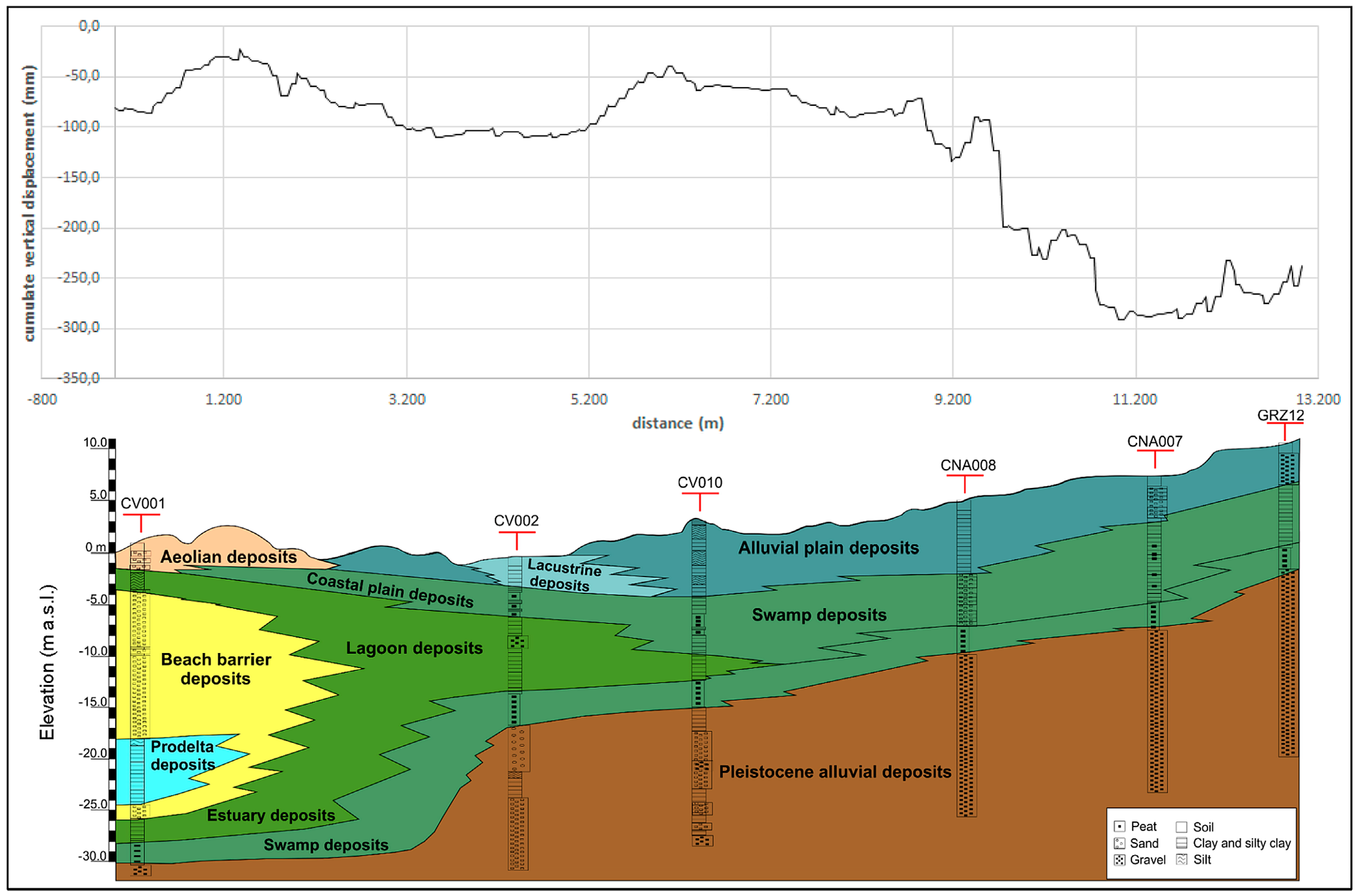
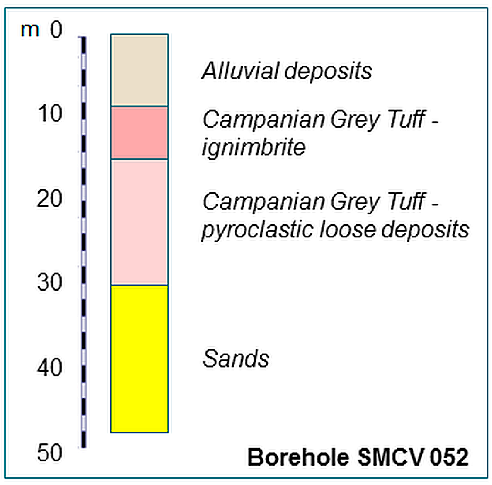
2. Geological, Geomorphological and Land Use Framework
3. Materials and Methods
4. Results
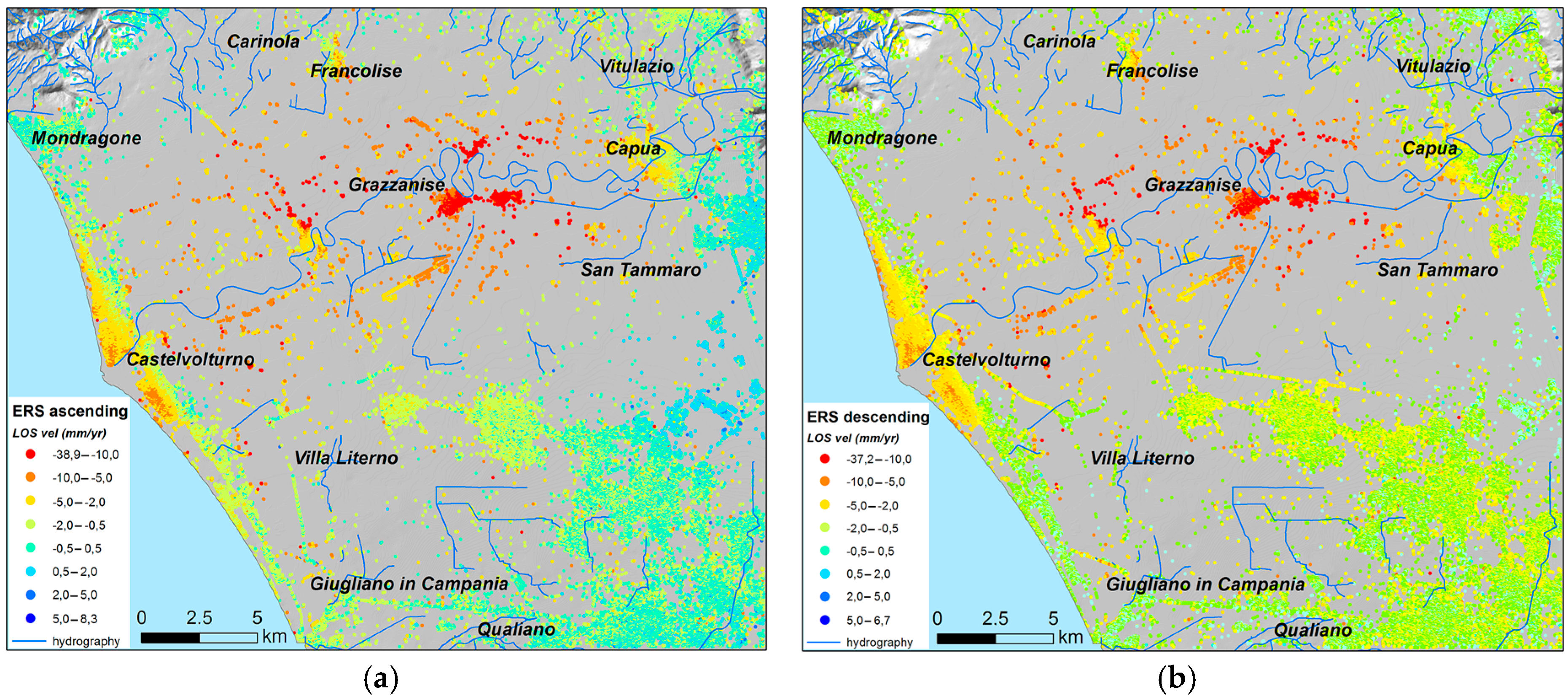
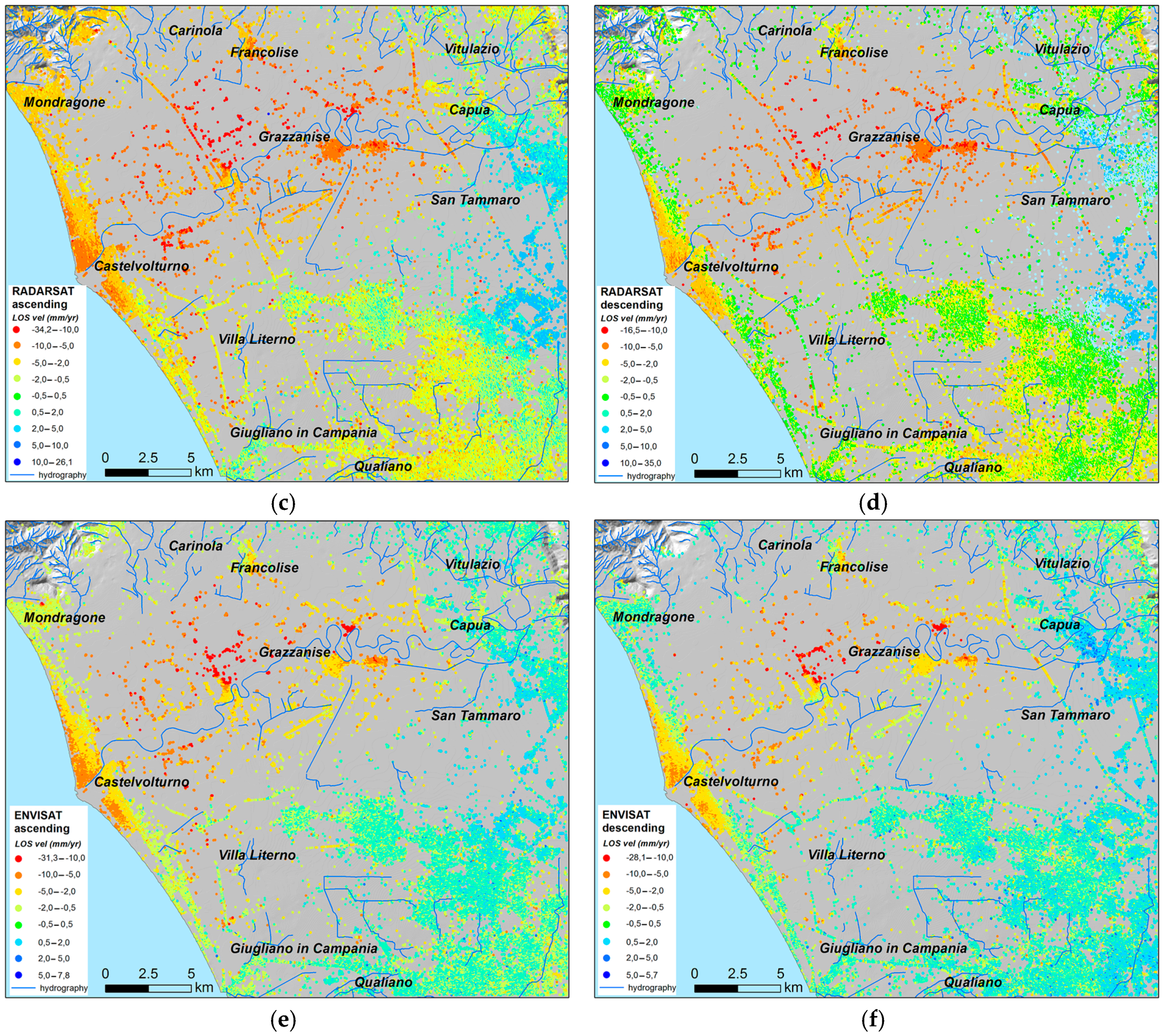
4.1. LOS Velocity Fields
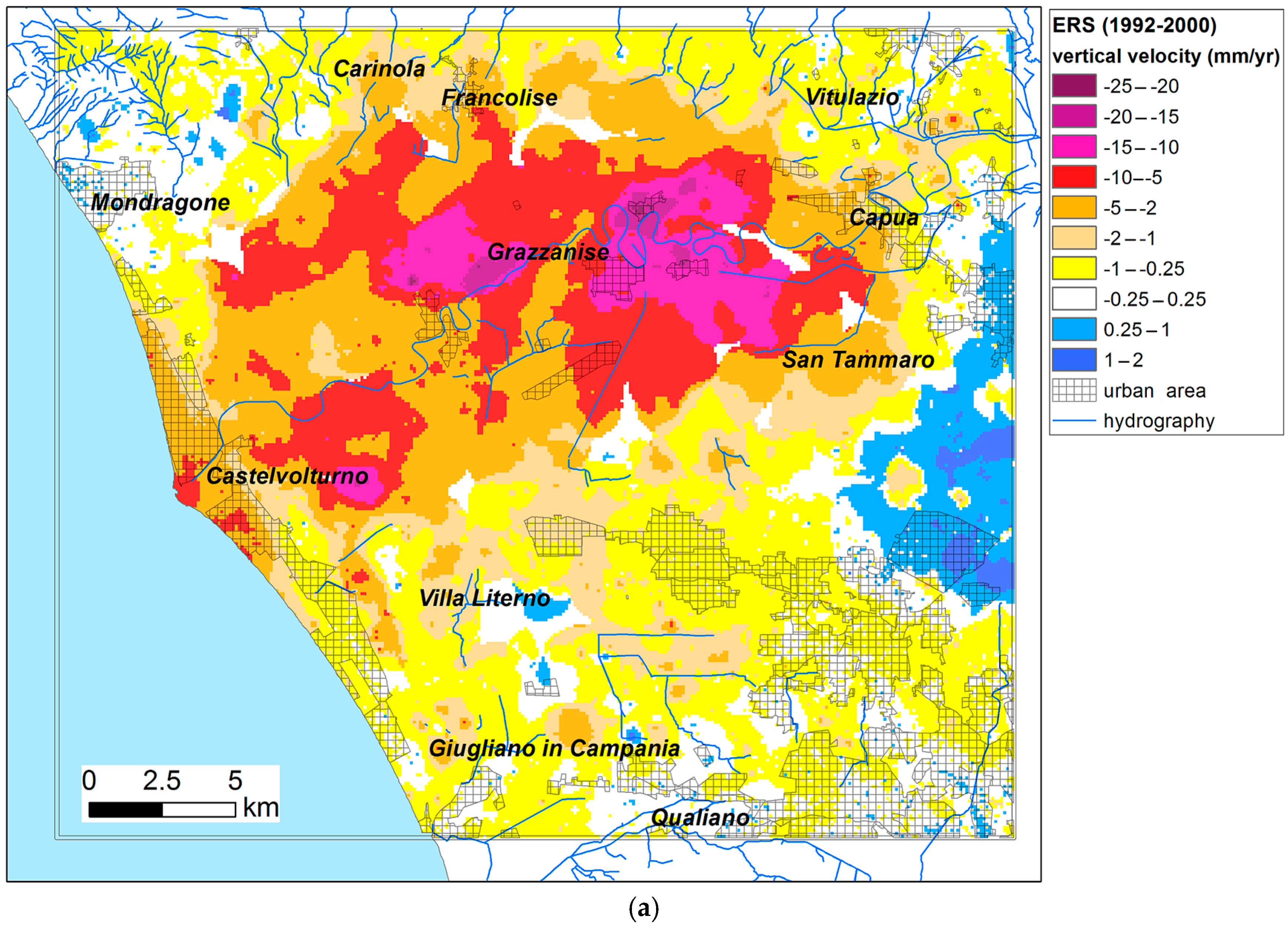
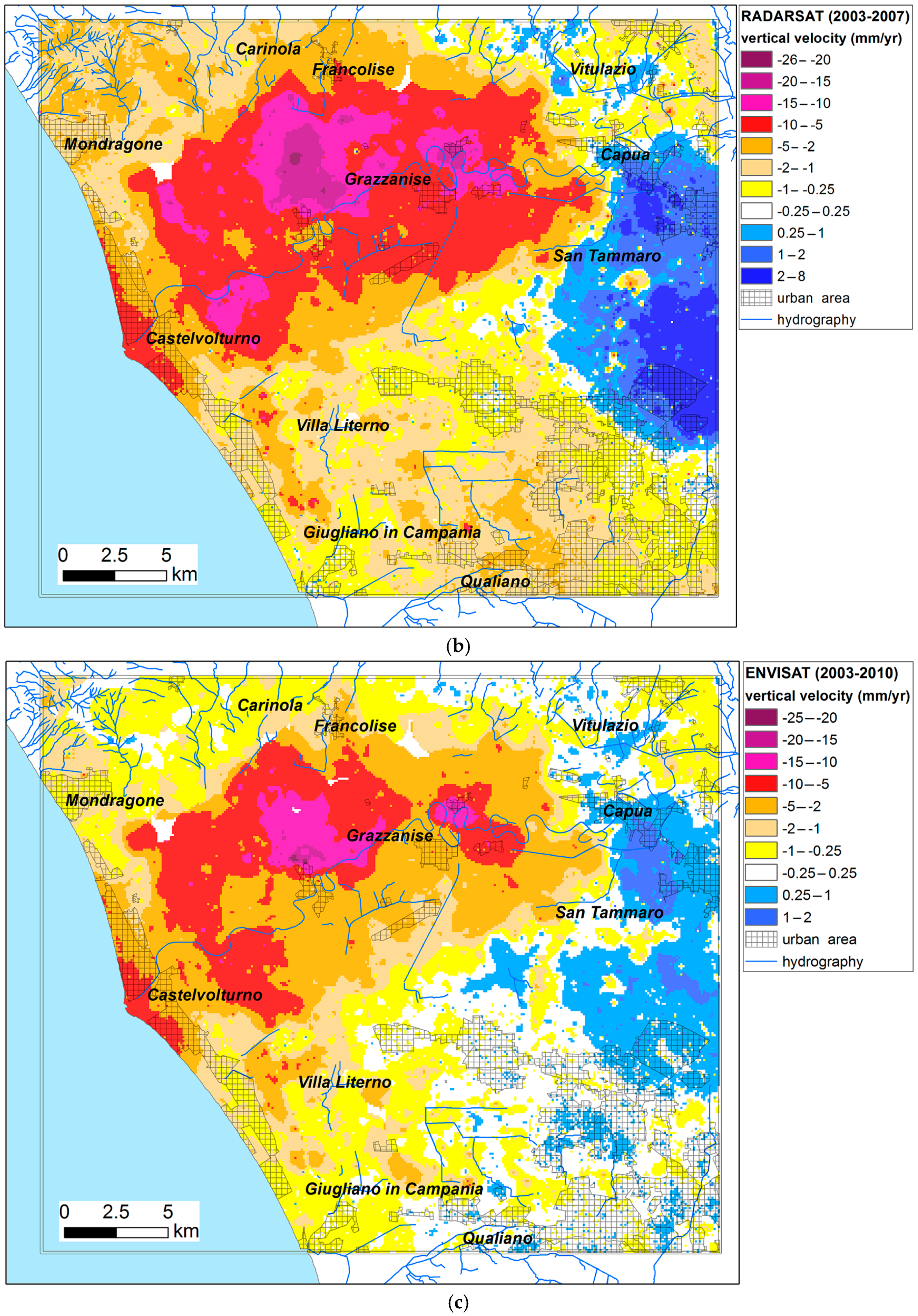
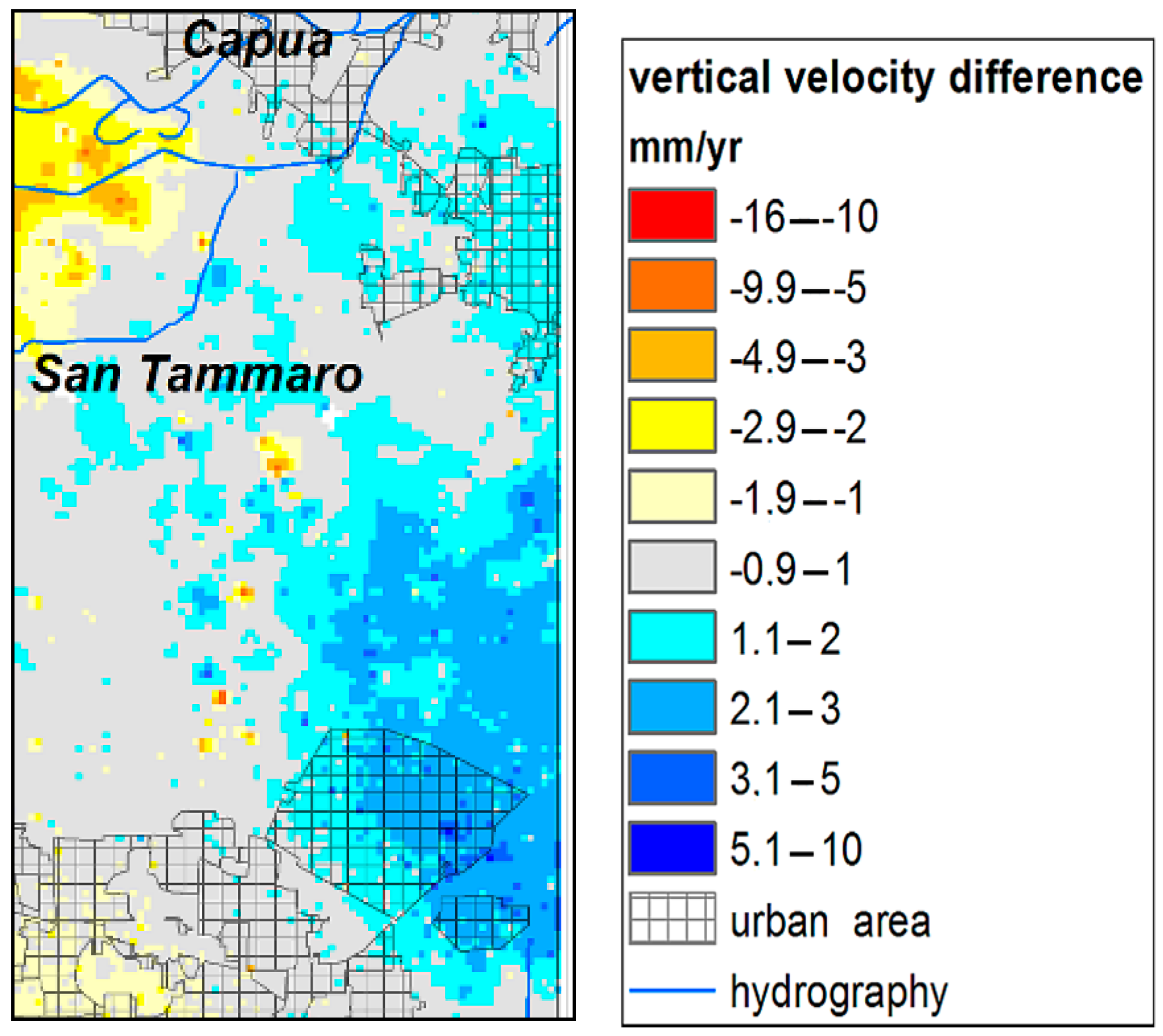
4.2. Vertical Components of Ground Deformation Velocity
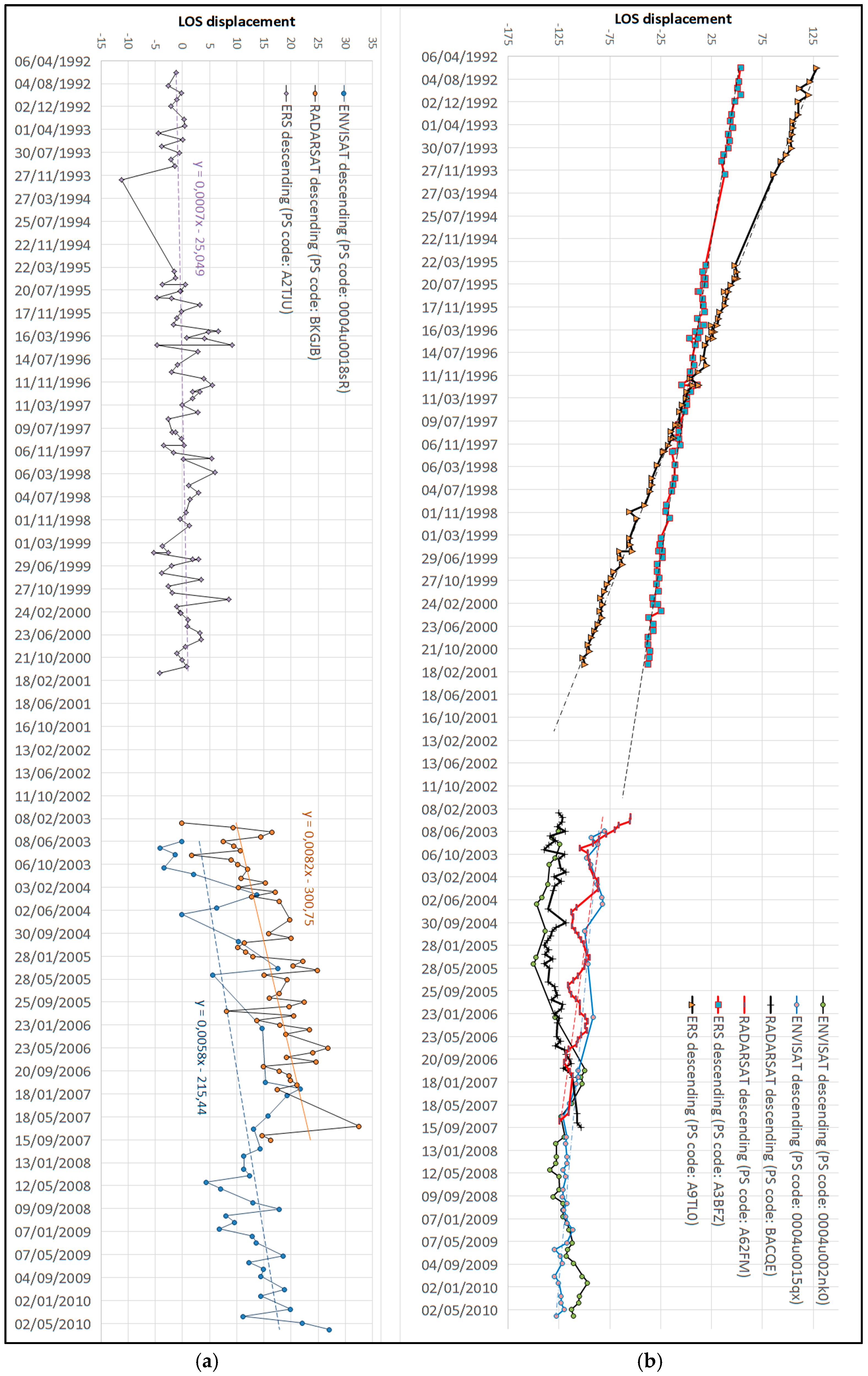
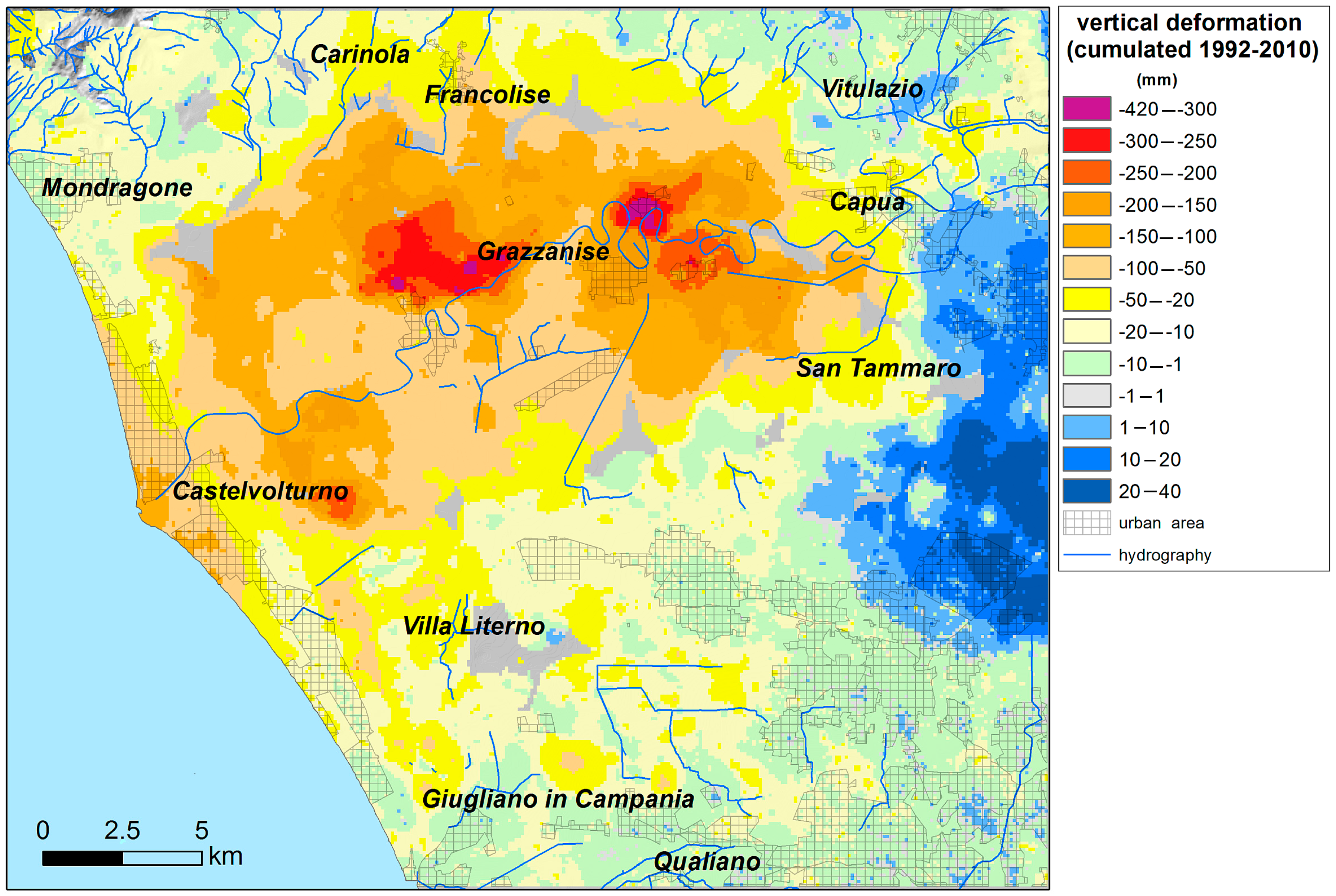
4.3. Subsidence Assessment
5. Discussion
6. Conclusions
- By averaging and cumulating the different datasets, it was possible to minimize the contributions resulting from the different acquisition geometries (LOS angles) and SAR technique processing (PS-InSAR and PSP) of ERS-1/2—ENVISAT satellite data with respect to the RADARSAT satellite data;
- By using multi-annual time series with different durations, it was possible to encompass a longer time period of observation, so that the final results of cumulated amount of vertical ground displacement is less affected by local and short-term changes.
Acknowledgments
Author Contributions
Conflicts of Interest
References
- Frihy, O.E.; El Sayed, E.E.; Deabes, E.A.; Gamai, I.H. Shelf sediments of Alexandria region, Egypt: Explorations and evaluation of offshore sand sources for beach nourishment and transport dispersion. Mar. Georesour. Geotechnol. 2010, 28, 250–274. [Google Scholar] [CrossRef]
- Teatini, P.; Tosi, L.; Strozzi, T. Quantitative evidence that compaction of Holocene sediments drives the present land subsidence of the Po Delta, Italy. J. Geophys. Res. 2011, 116, 1–10. [Google Scholar] [CrossRef]
- Teatini, P.; Tosi, L.; Strozzi, T.; Carbognin, L.; Cecconi, G.; Rosselli, R.; Libardo, S. Resolving land subsidence within the Venice Lagoon by persistent scatterer SAR interferometry. Phys. Chem. Earth 2012, 40, 72–79. [Google Scholar] [CrossRef]
- Higgins, S.A. Review: Advances in delta-subsidence research using satellite methods. Hydrogeol. J. 2015, 24, 587–600. [Google Scholar] [CrossRef]
- Warrick, R.A.; Provost, C.L.; Meier, M.F.; Oerlemans, J.; Woodworth, P.L. Changes in sea level, Climate Change. In The Science of Climate Change; Cambridge University Press: Cambridge, UK, 1996; pp. 359–405. [Google Scholar]
- Xie, X.; Heller, P. Plate tectonics and basin subsidence history. Geol. Soc. Am. Bull. 2006, 121, 55–64. [Google Scholar] [CrossRef]
- Long, A.J.; Waller, M.P.; Stupples, P. Driving mechanisms of coastal change: Peat compaction and the destruction of late Holocene coastal wetlands. Mar. Geol. 2005, 225, 63–84. [Google Scholar] [CrossRef]
- Poland, J.F.; Davis, G.H. Land subsidence due to withdrawal of fluids. Rev. Eng. Geol. 1969, 2, 187–269. [Google Scholar]
- Galloway, D.L.; Burbey, T.J. Review: Regional land subsidence accompanying groundwater extraction. Hydrogeol. J. 2011, 19, 1459–1486. [Google Scholar] [CrossRef]
- Burgmann, R.; Rosen, P.A.; Fielding, E.J. Synthetic aperture radar interferometry to measure Earth’s surface topography and its deformation. Annu. Rev. Earth Planet. Sci. 2000, 28, 169–209. [Google Scholar] [CrossRef]
- Strozzi, T.; Wegmüller, U.; Tosi, L.; Bitelli, G.; Spreckels, V. Land subsidence monitoring with differential SAR interferometry. Photogramm. Eng. Remote Sens. 2001, 67, 1261–1270. [Google Scholar]
- Herrera, G.; Fernández, J.A.; Tomás, R.; Cooksley Mulas, G.J. Advanced interpretation of subsidence in Murcia (SE Spain) using A-DInSAR data-modelling and validation. Nat. Hazards Earth Syst. Sci. 2009, 9, 647–661. [Google Scholar] [CrossRef]
- Terranova, C.; Iuliano, S.; Matano, F.; Nardo, S.; Piscitelli, E.; Cascone, E.; D’Argenio, F.; Gelli, L.; Alfinito, M.; Luongo, G. The TELLUS Project: A satellite-based slow-moving landslides monitoring system in the urban areas of Campania Region. Rend. Online Soc. Geol. Ital. 2009, 8, 148–151. [Google Scholar]
- Hanseen, R.F. Radar Interferometry, Data Interpretation and Error Analysis; Kluwer Academic Publishers: Dordrecht, The Netherlands, 2001; ISBN 978-0792369455. [Google Scholar]
- Hooper, A.; Zebker, H.; Segall, P.; Kampes, B. A new method for measuring deformation on volcanoes and other natural terrains using InSAR persistent scatterers. Geophys. Res. Lett. 2004, 31, 1–5. [Google Scholar] [CrossRef]
- Vilardo, G.; Ventura, G.; Terranova, C.; Matano, F.; Nardò, S. Ground deformation due to tectonic, hydrothermal, gravity, hydrogeological and anthropic processes in the Campania Region (Southern Italy) from Permanent Scatterers Synthetic Aperture Radar Interferometry. Remote Sens. Environ. 2009, 113, 197–212. [Google Scholar] [CrossRef]
- Tofani, V.; Raspini, F.; Catani, F.; Casagli, N. Persistent Scatterer Interferometry (PSI) Technique for Landslide Characterization and Monitoring. Remote Sens. 2013, 5, 1045–1065. [Google Scholar] [CrossRef]
- Gabriel, A.K.; Goldstein, R.M.; Zebker, H.A. Mapping small elevation changes over large areas: Differential radar interferometry. J. Geophys. Res. 1989, 94, 9183–9191. [Google Scholar] [CrossRef]
- Costantini, M.; Falco, S.; Malvarosa, F.; Minati, F.; Trillo, F.; Vecchioli, F. Persistent Scatterer Pair Interferometry: Approach and Application to COSMO-SkyMed SAR Data. IEEE J. Sel. Top. Appl. Earth Obs. Remote Sens. 2014, 7, 2869–2879. [Google Scholar] [CrossRef]
- Regione Campania—Settore Difesa del Suolo. Progetto TELLUS WebGIS (PSInSAR). 2009. Available online: http://webgis.difesa.suolo.regione.campania.it:8080/psinsar/map.phtml (accessed on 3 September 2017).
- Regione Campania—Settore Difesa del Suolo. Progetto TELLUS web page. 2009. Available online: http://www.difesa.suolo.regione.campania.it/content/category/4/64/92/ (accessed on 3 September 2017).
- Terranova, C.; Iuliano, S.; Matano, F.; Nardò, S.; Piscitelli, E. Relazione finale del Progetto TELLUS. PODIS Project of the Italian Ministry of Environment and of Protection of Territory and Sea—Campania Region. 2009. Available online: http://www.difesa.suolo.regione.campania.it/content/category/4/64/92/ (accessed on 3 September 2017).
- EPRS-E. Not-Ordinary Plan of Environmental Remote Sensing Web Page. National Geoportal (NG) of the Italian Ministry of Environment and of Protection of Territory and Sea. 2015. Available online: http://www.pcn.minambiente.it/GN/en/projects/not-ordinary-plan-of-remote-sensing (accessed on 3 September 2017).
- EPRS-E. Not-Ordinary Plan of Environmental Remote Sensing; ENVISAT Ascending e ENVISAT Descending Interferometric Products. National Geoportal (NG) of the Italian Ministry of Environment and of Protection of Territory and Sea. 2015. Available online: http://www.pcn.minambiente.it/viewer/ (accessed on 3 September 2017).
- IREA-CNR InSAR WebGIS. Napoli Study Area. 2017. ENVISAT Dataset. Available online: http://webgis.irea.cnr.it/webgis.html (accessed on 3 September 2017).
- Trasatti, E.; Casu, F.; Giunchi, C.; Pepe, S.; Solaro, G.; Tagliaventi, S.; Berardino, P.; Manzo, M.; Pepe, A.; Ricciardi, G.P.; et al. The 2004–2006 uplift episode at Campi Flegrei caldera (Italy): Constraints from SBAS-DInSAR ENVISAT data and Bayesian source inference. Geophys. Res. Lett. 2008, 35, 1–6. [Google Scholar] [CrossRef]
- Ferretti, A.; Prati, C.; Rocca, F. Permanent Scatterers in SAR Interferometry. IEEE Trans. Geosci. Remote Sens. 2001, 39, 8–20. [Google Scholar] [CrossRef]
- Costantini, M.; Falco, S.; Malvarosa, F.; Minati, F. A new method for identification and analysis of persistent scatterers in series of SAR images. In Proceedings of the 2008 IEEE International Geoscience and Remote Sensing Symposium (IGARSS), Boston, MA, USA, 7–11 July 2008; pp. 449–452. [Google Scholar]
- Costantini, M.; Falco, S.; Malvarosa, F.; Minati, F.; Trillo, F. Method of Persistent Scatterer Pairs (PSP) and high resolution SAR interferometry. In Proceedings of the 2009 IEEE International Geoscience and Remote Sensing Symposium (IGARSS), Cape Town, South Africa, 12–17 July 2009; Volume 3, pp. 904–907. [Google Scholar]
- Berardino, P.; Fornaro, G.; Lanari, R.; Sansosti, E. A new algorithm for surface deformation monitoring based on small baseline differential SAR interferograms. IEEE Trans. Geosci. Remote Sens. 2002, 40, 2375–2383. [Google Scholar] [CrossRef]
- Lanari, R.; Mora, O.; Manunta, M.; Mallorquí, J.J.; Berardino, P.; Sansosti, E. A small baseline approach for investigating deformation on full resolution differential SAR interferograms. IEEE Trans. Geosci. Remote Sens. 2004, 42, 1377–1386. [Google Scholar] [CrossRef]
- Lanari, R.; Casu, F.; Manzo, M.; Zeni, G.; Berardino, P.; Manunta, M. An overview of the Small Baseline subset algorithm: A DInSAR technique for surface deformation analysis. Pure Appl. Geophys. 2007, 164, 637–661. [Google Scholar] [CrossRef]
- Vilardo, G.; Isaia, R.; Ventura, G.; De Martino, P.; Terranova, C. InSAR Permanent Scatterer analysis reveals fault re-activation during inflation and deflation episodes at Campi Flegrei caldera. Remote Sens. Environ. 2010, 114, 2373–2383. [Google Scholar] [CrossRef]
- Iuliano, S.; Matano, F.; Caccavale, M.; Sacchi, M. Annual rates of ground deformation (1993–2010) at Campi Flegrei, Italy, revealed by Persistent Scatterer Pair (PSP)—SAR interferometry. Int. J. Remote Sens. 2015, 36, 6160–6191. [Google Scholar] [CrossRef]
- Terranova, C.; Ventura, G.; Vilardo, G. Multiple causes of ground deformation in the Napoli metropolitan area (Italy) from integrated Persistent Scatterers Din-SAR, geological, hydrological, and urban infrastructure data. Earth Sci. Rev. 2015, 146, 105–119. [Google Scholar] [CrossRef]
- Peduto, D.; Cascini, L.; Arena, L.; Ferlisi, S.; Fornaro, G.; Reale, D. A general framework and related procedures for multiscale analyses of DInSAR data in subsiding urban areas. ISPRS J. Photogramm. Remote Sens. 2015, 105, 186–210. [Google Scholar] [CrossRef]
- Aucelli, C.P.P.; Di Paola, G.; Incontri, P.; Rizzo, A.; Vilardo, G.; Benassai, G.; Buonocore, B.; Pappone, G. Coastal inundation risk assessment due to subsidence and sea level rise in a Mediterranean alluvial plain (Volturno coastal plain e southern Italy). Estuar. Coast. Shelf Sci. 2016, 198, 597–609. [Google Scholar] [CrossRef]
- Di Paola, G.; Alberico, I.; Aucelli, P.P.C.; Matano, F.; Rizzo, A.; Vilardo, G. Coastal subsidence detected by Synthetic Aperture Radar interferometry and its effects coupled with future sea-level rise: The case of the Sele Plain (Southern Italy). J. Flood Risk Manag. 2017. [Google Scholar] [CrossRef]
- Cocco, E.; Crimaco, L.; de Magistris, M.A. Dinamica ed evoluzione del litorale campano-laziale: Variazioni della linea di riva dall’epoca romana ad oggi nel tratto compreso tra la foce del Volturno e Torre S. In Proceedings of the “10° Congresso AIOL”, Mondragone, Italy, 4–6 November 1992; pp. 543–555. [Google Scholar]
- Donadio, C.; Vigliotti, M.; Valente, R.; Stanislao, C.; Ivaldi, R.; Ruberti, D. Anthropic vs. natural shoreline changes along the northern Campania coast, Italy. J. Coast. Cons. 2017. [Google Scholar] [CrossRef]
- Ruberti, D.; Vigliotti, M.; Di Mauro, A.; Chieffi, R.; Di Natale, M. Human influence over 150 years of coastal evolution in the Volturno delta system (southern Italy). J. Coast. Cons. 2017. [Google Scholar] [CrossRef]
- Ruberti, D.; Vigliotti, M. Land use and landscape pattern changes driven by land reclamation in a coastal area. The case of Volturno delta plain, Campania Region, southern Italy. Environ. Earth Sci. 2017, 76, 694. [Google Scholar]
- ENEA. Analisi di specifiche situazioni di degrado della qualità delle acque in Campania. In Riferimento ai Casi Che Maggiormente Incidono Negativamente Sulle Aree Costiere; ENEA, Sezione Protezione-Idrogeologica: Roma, Italy, 2008. [Google Scholar]
- Riccio, T. Analysis of Subsidence in Campania Plain. Ph.D. Thesis, cycle XXVIII, University of Campania “L. Vanvitelli”, Aversa, Italy, 2016; p. 67. [Google Scholar]
- Patacca, E.; Sartori, R.; Scandone, P. Tyrrhenian basin and Apenninic arcs: Kinematic relations since late Tortonian times. Mem. Soc. Geol. Ital. 1990, 45, 425–451. [Google Scholar]
- Oldow, J.S.; D’Argenio, B.; Ferranti, L.; Pappone, G.; Marsella, E.; Sacchi, M. Large-scale longitudinal extension in the southern Apennines contractional belt, Italy. Geology 1993, 21, 1123–1126. [Google Scholar] [CrossRef]
- Ferranti, L.; Oldow, J.S.; Sacchi, M. Pre-Quaternary orogen-parallel extension in the Southern Apennine belt, Italy. Tectonophysics 1996, 260, 325–347. [Google Scholar] [CrossRef]
- Casciello, E.; Cesarano, M.; Pappone, G. Extensional detachment faulting on the Tyrrhenian margin of the southern Apennines contractional belt (Italy). J. Geol. Soc. Lond. 2006, 163, 617–629. [Google Scholar] [CrossRef]
- Di Nocera, S.; Matano, F.; Pescatore, T.; Pinto, F.; Torre, M. Geological characteristics of the external sector of the Campania-Lucania Apennines in the CARG maps. Rend. Online Soc. Geol. Ital. 2011, 12, 39–43. [Google Scholar]
- Matano, F.; Critelli, S.; Barone, M.; Muto, F.; Di Nocera, S. Stratigraphic and provenance evolution of the Southern Apennines foreland basin system during the Middle Miocene to Pliocene (Irpinia-Sannio successions, Italy). Mar. Petr. Geol. 2014, 57, 652–670. [Google Scholar] [CrossRef]
- Cinque, A.; Ascione, A.; Caiazzo, C. Distribuzione spazio-temporale e caratterizzazione della fagliazione quaternaria in Appennino meridionale. In Le Ricerche del GNDT nel Campo Della Pericolosità Sismica 1996–1999; Galadini, F., Meletti, C., Rebez, A., Eds.; CNR-Gruppo Nazionale per la Difesa dai Terremoti: Roma, Italy, 2000; pp. 203–218. [Google Scholar]
- Mariani, M.; Prato, R. I bacini neogenici costieri del margine tirrenico: Approccio sismico-stratigrafico. Mem. Della Soc. Geol. Ital. 1988, 41, 519–531. [Google Scholar]
- Milia, A.; Torrente, M.M. Late Quaternary volcanism and transtensional tectonics in the Naples Bay, Campanian continental margin, Italy. Miner. Petrol. 2003, 79, 49–65. [Google Scholar] [CrossRef]
- Milia, A.; Torrente, M.M.; Massa, B.; Iannace, P. Progressive changes in rifting directions in the Campania margin (Italy): New constrains for the Tyrrhenian Sea opening. Glob. Planet. Chang. 2013, 109, 3–17. [Google Scholar] [CrossRef]
- Ortolani, F.; Aprile, F. Nuovi dati sulla struttura profonda della Piana Campana a sud-est del fiume Volturno. Boll. Soc. Geol. Ital. 1978, 97, 591–608. [Google Scholar]
- Scandone, R.; Bellucci, F.; Lirer, L.; Rolandi, G. The structure of the Campanian Plain and the activity of the Neapolitain volcanoes (Italy). J. Volcanol. Geotherm. Res. 1991, 48, 1–31. [Google Scholar] [CrossRef]
- Barberi, F.; Innocenti, F.; Lirer, L.; Munno, R.; Pescatore, T.; Santacroce, R. The Campanian Ignimbrite: A major prehistoric eruption in the Neapolitan area (Italy). Bull. Volcanol. 1978, 41, 1–22. [Google Scholar] [CrossRef]
- Di Girolamo, P.; Ghiara, M.R.; Lirer, L.; Munno, R.; Rolandi, G.; Stanzione, D. Vulcanologia e Petrologia dei Campi Flegrei. Boll. Soc. Geol. 1984, 103, 349–413. [Google Scholar]
- Deino, A.L.; Southon, I.; Terrasi, F.; Campajola, L.; Orsi, G. 14C and 40Ar/39Ar dating of the Campanian Ignimbrite. Phlegrean Fields, Italy. In Proceedings of the 8th International Conference on Geochronology, Cosmochronology and Isotope Geology (ICOG), Berkeley, CA, USA, 5–11 June 1994; Volume 3, p. 633. [Google Scholar]
- De Vivo, B.; Rolandi, G.; Gans, P.B.; Calvert, A.; Bohrson, W.A.; Spera, F.J.; Belkin, H.E. New constraints on the pyroclastic eruptive history of the Campanian volcanic plain (Italy). Miner. Petrol. 2001, 73, 47–65. [Google Scholar] [CrossRef]
- Deino, A.L.; Orsi, G.; de Vita, S.; Piochi, M. The age of the Neapolitan Yellow Tuff caldera-forming eruption (Campi Flegrei caldera, Italy) assessed by Ar-40/Ar-39 dating method. J. Volcanol. Geotherm. Res. 2004, 133, 157–170. [Google Scholar] [CrossRef]
- Amorosi, A.; Pacifico, A.; Rossi, V.; Ruberti, D. Late Quaternary incision and deposition in an active volcanic setting: The Volturno valley fill, southern Italy. Sediment. Geol. 2012, 282, 307–320. [Google Scholar] [CrossRef]
- Sacchi, M.; Molisso, F.; Pacifico, A.; Vigliotti, M.; Sabbarese, C.; Ruberti, D. Late-Holocene to recent evolution of Lake Patria, South Italy: An example of a coastal lagoon within a Mediterranean delta system. Glob. Planet. Chang. 2014, 117, 9–27. [Google Scholar] [CrossRef]
- Pappone, G.; Alberico, I.; Amato, V.; Aucelli, P.P.C.; Di Paola, G. Recent evolution and the present-day conditions of the Campanian Coastal plains (South Italy): The case history of the Sele River Coastal plain. WIT Trans. Ecol. Environ. 2011, 149, 15–27. [Google Scholar]
- Scorpio, V.; Aucelli, P.P.C.; Giano, S.I.; Pisano, L.; Robustelli, G.; Rosskopf, C.M.; Schiattarella, M. River channel adjustments in Southern Italy over the past 150 years and implications for channel recovery. Geomorphology 2015, 251, 77–90. [Google Scholar] [CrossRef]
- Barra, D.; Romano, P.; Santo, A.; Campaiola, L.; Roca, V.; Tuniz, C. The Versilian transgression in the Volturno river plain (Campania, Southern Italy): Palaeoenvironmental history and chronological data. II Quaternario 1996, 9, 445–458. [Google Scholar]
- Amorosi, A.; Molisso, F.; Pacifico, A.; Rossi, V.; Ruberti, D.; Sacchi, M.; Vigliotti, M. The Holocene evolution of the Volturno River coastal plain (southern Italy). J. Mediter. Earth Sci. 2013, 5, 7–11. [Google Scholar]
- Romano, P.; Santo, A.; Voltaggio, M. L’evoluzione morfologica della pianura del fiume Volturno (Campania) durante il tardo Quaternario. II Quaternario 1994, 7, 41–56. [Google Scholar]
- Lambeck, K.; Antonioli, F.; Anzidei, M.; Ferranti, L.; Leoni, G.; Scicchitano, G.; Silenzi, S. Sea level change along the Italian coast during the Holocene and projections for the future. Quat. Int. 2011, 232, 250–257. [Google Scholar] [CrossRef]
- Putignano, M.L.; Ruberti, D.; Tescione, M.; Vigliotti, M. Evoluzione recente di un territorio di pianura a forte sviluppo urbano: La Piana Campana nell’area di Caserta. Boll. Soc. Geol. Ital. 2007, 126, 11–24. [Google Scholar]
- Lu, Z.; Kwoun, O.; Rykus, R. Interferometric syntetic aperture radar (InSAR): Its past, present and future. Photogramm. Eng. Remote Sens. 2007, 73, 217–221. [Google Scholar]
- Rott, H. Advances in interferometric synthetic aperture radar (InSAR) in earth system science. Prog. Phys. Geogr. 2009, 33, 769–791. [Google Scholar] [CrossRef]
- Vasco, D.W.; Rucci, A.; Ferretti, A.; Novali, F.; Bissell, R.C.; Ringrose, P.S.; Mathieson, A.S.; Wright, I.W. Satellite-based measurements of surface deformation reveal fluid flow associated with the geological storage of carbon dioxide. Geophys. Res. Lett. 2010, 37, L03303. [Google Scholar] [CrossRef]
- Colesanti, C.; Locatelli, R.; Novali, F. Ground deformation monitoring exploiting SAR permanent scatterers. IEEE IGARSS 2002, 2, 1219–1221. [Google Scholar]
- Colesanti, C.; Ferretti, A.; Locatelli, R.; Novali, F.; Savio, G. Permanent Scatterers: Precision assessment and multi-platform analysis. IEEE IGARSS 2003, 2, 1193–1195. [Google Scholar]
- Colesanti, C.; Wasowski, J. Investigating landslides with spaceborne synthetic aperture radar (SAR) interferometry. Eng. Geol. 2006, 88, 173–199. [Google Scholar] [CrossRef]
- Ferretti, A.; Savio, G.; Barzaghi, R.; Borghi, A.; Musazzi, S.; Novali, F.; Prati, C.; Rocca, F. Submillimeter accuracy of InSAR time series: Experimental validation. IEEE Trans. Geosci. Remote Sens. 2007, 45, 1142–1153. [Google Scholar] [CrossRef]
- Massironi, M.; Zampieri, D.; Bianchi, M.; Schiavo, A.; Franceschini, A. Use of PSInSAR™ data to infer active tectonics: Clues on the differential uplift across the Giudicarie belt (Central-Eastern Alps, Italy). Tectonophysics 2009, 476, 297–303. [Google Scholar] [CrossRef]
- Franke, R. Scattered data interpolation: Test of some methods. Math. Comput. 1982, 33, 181–200. [Google Scholar]
- Mueller, T.G.; Pusuluri, N.B.; Mathias, K.K.; Cornelius, P.L.; Barnhisel, R.I.; Shearer, S.A. Map quality for ordinary kriging and inverse distance weighted interpolation. Soil Sci. Soc. Am. J. 2004, 68, 2042–2047. [Google Scholar] [CrossRef]
- Lundgren, P.; Casu, F.; Manzo, M.; Pepe, A.; Berardino, P.; Sansosti, E.; Lanari, R. Gravity and magma induced spreading of Mount Etna volcano revealed by satellite radar interferometry. Geophys. Res. Lett. 2004, 31, L04602. [Google Scholar] [CrossRef]
- Manzo, M.; Ricciardi, G.P.; Casu, F.; Ventura, G.; Zeni, G.; Borgström, S.; Berardino, P.; Del Gaudio, C.; Lanari, R. Surface deformation analysis in the Ischia island (Italy) based on spaceborne radar interferometry. J. Volcanol. Geotherm. Res. 2006, 151, 399–416. [Google Scholar] [CrossRef]
- Meckel, T.A.; Brink, U.S.; Williams, S.J. Sediment compaction rates and subsidence in deltaic plains: Numerical constraints and stratigraphic influences. Basin Res. 2007, 19, 19–31. [Google Scholar] [CrossRef]
- Meckel, T.A.; Brink, U.S.; Williams, S.J. Current subsidence rates due to compaction of Holocene sediments in southern Louisiana. Geophys. Res. Lett. 2006, 33, L11403. [Google Scholar] [CrossRef]
- Shi, C.; Zhang, D.; You, L.; Li, B.; Zhang, Z.; Zhang, O. Land subsidence as a result of sediment consolidation in the Yellow River Delta. J. Coast. Res. 2007, 23, 173–181. [Google Scholar]
- Tornqvist, T.E.; Wallace, D.J.; Storms, J.E.A.; Wallinga, J.; Van Dam, R.L.; Blaauw, M.; Derksen, M.S.; Klerks, C.J.W.; Meijneken, C.; Snijders, E.M.A. Mississippi Delta subsidence primarily caused by compaction of Holocene strata. Nat. Geosci. 2008, 1, 173–176. [Google Scholar] [CrossRef]
- Van Asselen, S. The contribution of peat compaction to total basin subsidence: Implications for the provision of accommodation space in organic-rich deltas. Basin Res. 2011, 23, 239–255. [Google Scholar] [CrossRef]


| Satellite-Orbit | Track/Frame | Line of Sight Incidence Angle | Used Scenes | Time Range |
|---|---|---|---|---|
| ENVISAT-Descending | 36/2781 | 22° | 41 | 5 June 2003–3 June 2010 |
| ENVISAT-Ascending | 358, 129/819 | 25° | 60 | 13 November 2002–30 July 2010 |
| RADARSAT-Ascending | 104/S3 | 34° | 52 | 4 March 2003–15 September 2007 |
| RADARSAT-Descending | 11, 111/S3 | 32–33° | 51 | 5 March 2003–23 August 2007 |
| ERS-1/2-Ascending | 129/801 | 22° | 69 | 14 June 1992–13 December 2000 |
| ERS-1/2-Descending | 36, 265/2781, 2783 | 23° | 81 | 8 June 1992–23 December 2001 |
| Satellite-Orbit | Persistent Scatterer Interferometry Technique | Count | PS Velocity-Mean (mm/year) | PS Stand. Dev.-Mean | PS Coherence-Mean | PS Density (Num./km2) |
|---|---|---|---|---|---|---|
| ENVISAT-Ascending | PSP | 105.319 | –0.88 | 0.31 | 0.73 | 136.8 |
| ENVISAT-Descending | PSP | 120.557 | –0.40 | 0.39 | 0.77 | 156.6 |
| RADARSAT-Ascending | PS-InSAR | 57.563 | –1.32 | 1.31 | 0.84 | 74.8 |
| RADARSAT-Descending | PS-InSAR | 55.324 | –0.96 | 0.72 | 0.85 | 71.8 |
| ERS-1/2-Ascending | PSP | 73.694 | –1.08 | 0.73 | 0.73 | 95.7 |
| ERS-1/2-Descending | PSP | 93.480 | –0.80 | 0.50 | 0.68 | 121.4 |
| Satellite-Orbit | Mean | Std. Dev. | Skewness | Q1 | Median | Q3 | IQR | −2 s.d. | +2 s.d. | Min | Max |
|---|---|---|---|---|---|---|---|---|---|---|---|
| ENVISAT-Ascending | −0.88 | 2.14 | −3.32 | −1.20 | −0.20 | +0.30 | 1.50 | −5.16 | +3.40 | −31.30 | +7.80 |
| ENVISAT-Descending | −0.40 | 1.88 | −3.16 | −0.80 | −0.01 | +0.60 | 1.40 | −4.16 | +3.36 | −28.10 | +5.70 |
| RADARSAT-Ascending | −1.32 | 2.60 | −1.49 | −2.25 | −0.83 | +0.10 | 2.35 | −6.52 | +3.88 | −34.25 | +26.09 |
| RADARSAT-Descending | −0.96 | 2.45 | −2.52 | −1.49 | −0.57 | +0.21 | 1.70 | −5.86 | +3.94 | −35.02 | +16.51 |
| ERS-1/2-Ascending | −1.08 | 2.41 | −3.62 | −1.26 | −0.46 | +0.08 | 1.34 | −5.90 | +3.74 | −38.87 | +8.26 |
| ERS-1/2-Descending | −0.80 | 2.23 | −3.47 | −1.05 | −0.26 | +0.31 | 1.36 | −5.26 | +3.66 | –37.22 | +6.71 |
© 2018 by the authors. Licensee MDPI, Basel, Switzerland. This article is an open access article distributed under the terms and conditions of the Creative Commons Attribution (CC BY) license (http://creativecommons.org/licenses/by/4.0/).
Share and Cite
Matano, F.; Sacchi, M.; Vigliotti, M.; Ruberti, D. Subsidence Trends of Volturno River Coastal Plain (Northern Campania, Southern Italy) Inferred by SAR Interferometry Data. Geosciences 2018, 8, 8. https://doi.org/10.3390/geosciences8010008
Matano F, Sacchi M, Vigliotti M, Ruberti D. Subsidence Trends of Volturno River Coastal Plain (Northern Campania, Southern Italy) Inferred by SAR Interferometry Data. Geosciences. 2018; 8(1):8. https://doi.org/10.3390/geosciences8010008
Chicago/Turabian StyleMatano, Fabio, Marco Sacchi, Marco Vigliotti, and Daniela Ruberti. 2018. "Subsidence Trends of Volturno River Coastal Plain (Northern Campania, Southern Italy) Inferred by SAR Interferometry Data" Geosciences 8, no. 1: 8. https://doi.org/10.3390/geosciences8010008
APA StyleMatano, F., Sacchi, M., Vigliotti, M., & Ruberti, D. (2018). Subsidence Trends of Volturno River Coastal Plain (Northern Campania, Southern Italy) Inferred by SAR Interferometry Data. Geosciences, 8(1), 8. https://doi.org/10.3390/geosciences8010008