Brief Report

Crustal-Scale Duplexes Beneath the Eastern Rioni Foreland Basin in Western Georgia: A Case Study from Seismic Reflection Profile

by
Victor Alania
1,*,
Onise Enukidze
1,
Nino Kvavadze
1,
Tamar Beridze
2,
Rusudan Chagelishvili
3,
Anzor Giorgadze
1,
George Melikadze
1 and
Alexander Razmadze
2
1
Institute of Geophysics, Ivane Javakhishvili Tbilisi State University, 0171 Tbilisi, Georgia
2
Alexander Janelidze Institute of Geology, Ivane Javakhishvili Tbilisi State University, 0186 Tbilisi, Georgia
3
Department of Geology and Paleontology, Georgian National Museum, 0105 Tbilisi, Georgia
*
Author to whom correspondence should be addressed.
Geosciences 2025, 15(8), 291; https://doi.org/10.3390/geosciences15080291 (registering DOI)
Submission received: 18 March 2025 / Revised: 24 July 2025 / Accepted: 26 July 2025 / Published: 1 August 2025
(This article belongs to the Section Structural Geology and Tectonics)

Abstract

Our understanding of foreland basin subsurface structures relies heavily on seismic reflection data. The seismic profile across the eastern Rioni foreland basin in western Georgia is critical for characterizing its deformation structural style. We applied fault-related folding and thrust wedge theories to interpret the seismic profile and construction structural cross-section, which reveals that compressional structures are controlled by multiple detachment levels. Both thin-skinned and thick-skinned structures are identified. The seismic profile and structural cross-section reveal the presence of normal faults, reverse faults, thrust faults, duplexes, triangle zone, and crustal-scale duplexes. The deep-level detachment within the basement is responsible for the development of the crustal-scale duplexes. These structures appear to have formed through the reactivation of pre-existing normal faults during compressive deformation. Based on our interpretation, the imaged duplex system likely represents the western subsurface continuation of the Dzirula Massif.

1. Introduction

The Rioni foreland basin (RFB) in western Georgia is located between the Greater Caucasus (GC) and Lesser Caucasus (LC) orogens, situated in the far-field zone of the Arabia–Eurasia collision zone, e.g., [1,2,3] (Figure 1a). The LC and GC are double-wedge orogenic systems that have undergone distinct tectonic evolutions, e.g., [4,5,6,7,8]. The LC experienced a sequence of characteristic tectonic events, subduction, obduction, and collision, which led to the formation of a double-wedge orogen [1,3,9]. In contrast, the GC developed as an intracontinental mountain belt resulting from the structural inversion of a Mesozoic–Early Cenozoic back-arc basin, e.g., [8,10,11,12,13,14]. Recent structural models of the GC indicate that the Kuban and Terek retro-foreland basins developed on the upper plate, while the Rioni and Kura pro-foreland basins formed on the lower, subducting plate, e.g., [3,11] (Figure 1b).
In western Georgia, the Imereti Uplift Zone (IUZ) and Dzirula Massif (DM) break a contiguous foreland basin into disconnected basins, the Rioni basin to the west and the Kura basin to the east (Figure 1b). Several structural studies have highlighted the thin-skinned tectonic styles of the Rioni and Kura basins, which are controlled by the interaction between two opposing orogenic fronts: the LC retro-wedge to the south and the GC pro-wedge to the north [3,4,5,6,7,15,16,17].
Over the past several decades, particularly during the Soviet period, extensive geophysical research was conducted to investigate the deep structure and seismicity of the Caucasus lithosphere [18,19,20]. Much of Georgia’s territory has been covered by gravity and magnetic surveys [18,19]. Longitudinal and transverse fault systems in Georgia were primarily determined using the total horizontal derivative of gravity, which was integrated with magnetic data [18]. These geophysical interpretations were coordinated with deep seismic sounding results, producing models of the continental crust structure and Moho depth beneath the Rioni and Kura basins [18,19]. The geophysical models mentioned above show that the DM uplift is divided into the western and eastern subsidence zones, which in turn disintegrate into separate blocks [18,19,20]. However, these earlier models depict a relatively simple deep crustal structure and differ substantially from more recent seismic profile interpretations from the Rioni and Kura basins, e.g., [3,6]. Numerous seismic events have occurred in the RFB and its surrounding areas, most of which were small earthquakes [21,22,23,24]. Previous studies indicated that strong earthquakes took place on the basement thrust faults in the epicentral area of the Racha 1991 (MW = 7) earthquake [22,23] (Figure 2). Earthquake focal mechanisms predominantly indicate thrust and reverse faulting, e.g., [21,22,23,24]. Geodetic and seismic data suggest that present-day convergence within the RFB is approximately 2 mm/yr [25]. However, the major structures accommodating convergence between the LC and GC remain poorly understood in the eastern part of the RFB [24].
The study area is located in the eastern part of the RFB (Figure 2). Over the past several years, research has focused primarily on the structural evolution of the western RFB, e.g., [3,5,15,16,17]. In contrast, the eastern RFB (Figure 2), including its deep structure and tectonic relationship to the DM, remains poorly understood. In this study, we present new subsurface constraints using a seismic profile combined with the field geologic observations and borehole information that define the basement geometry and deformation structural style of the eastern RFB. This study documents the controls exerted by pre-existing basement structures on the eastern RFB geometry during the Late Cenozoic deformation.
Figure 1. (a) Tectonic map of the Arabia–Eurasia collision zone [1]. (b) Tectonic map of the Caucasus [3].
Geosciences 15 00291 g001

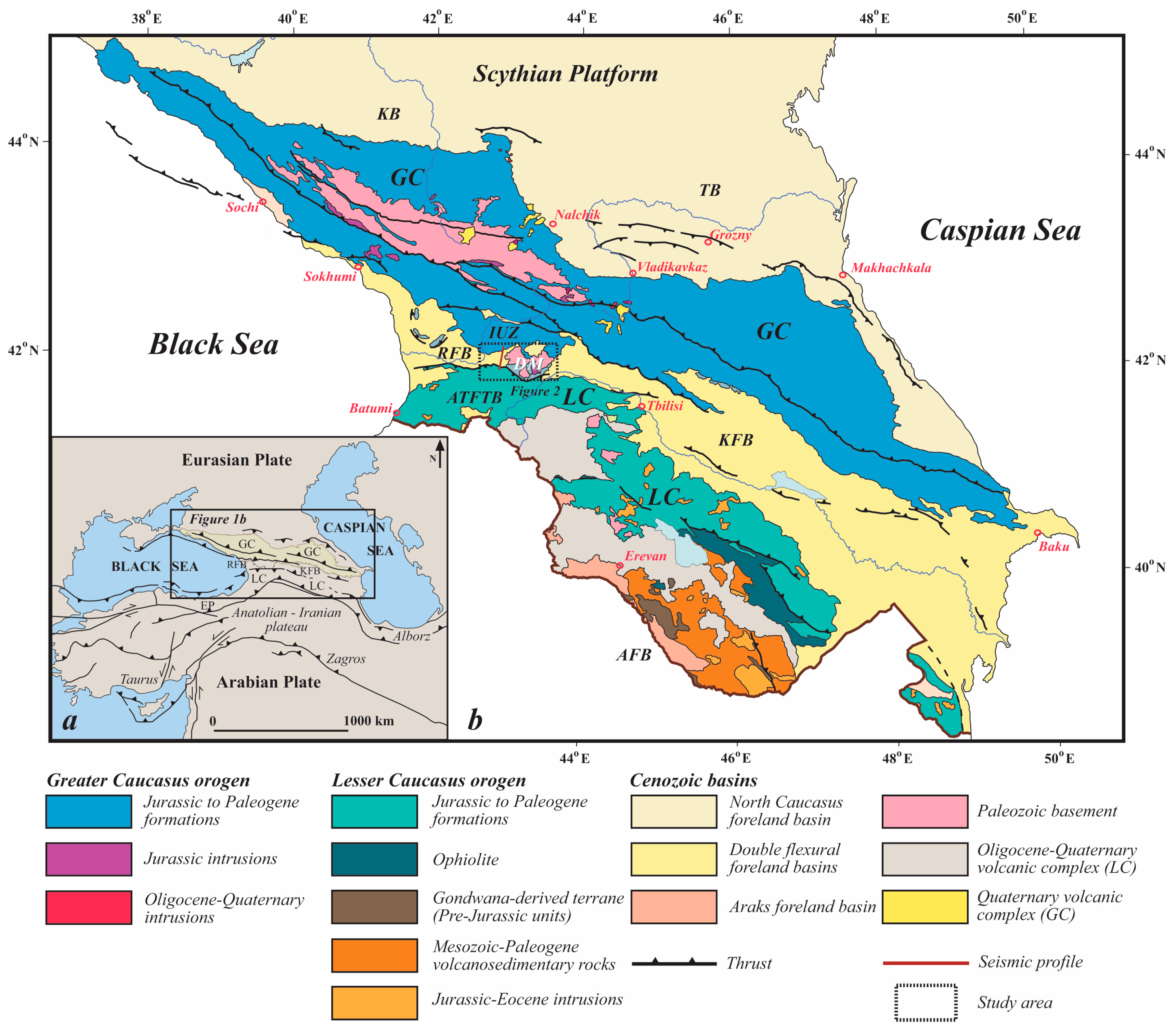
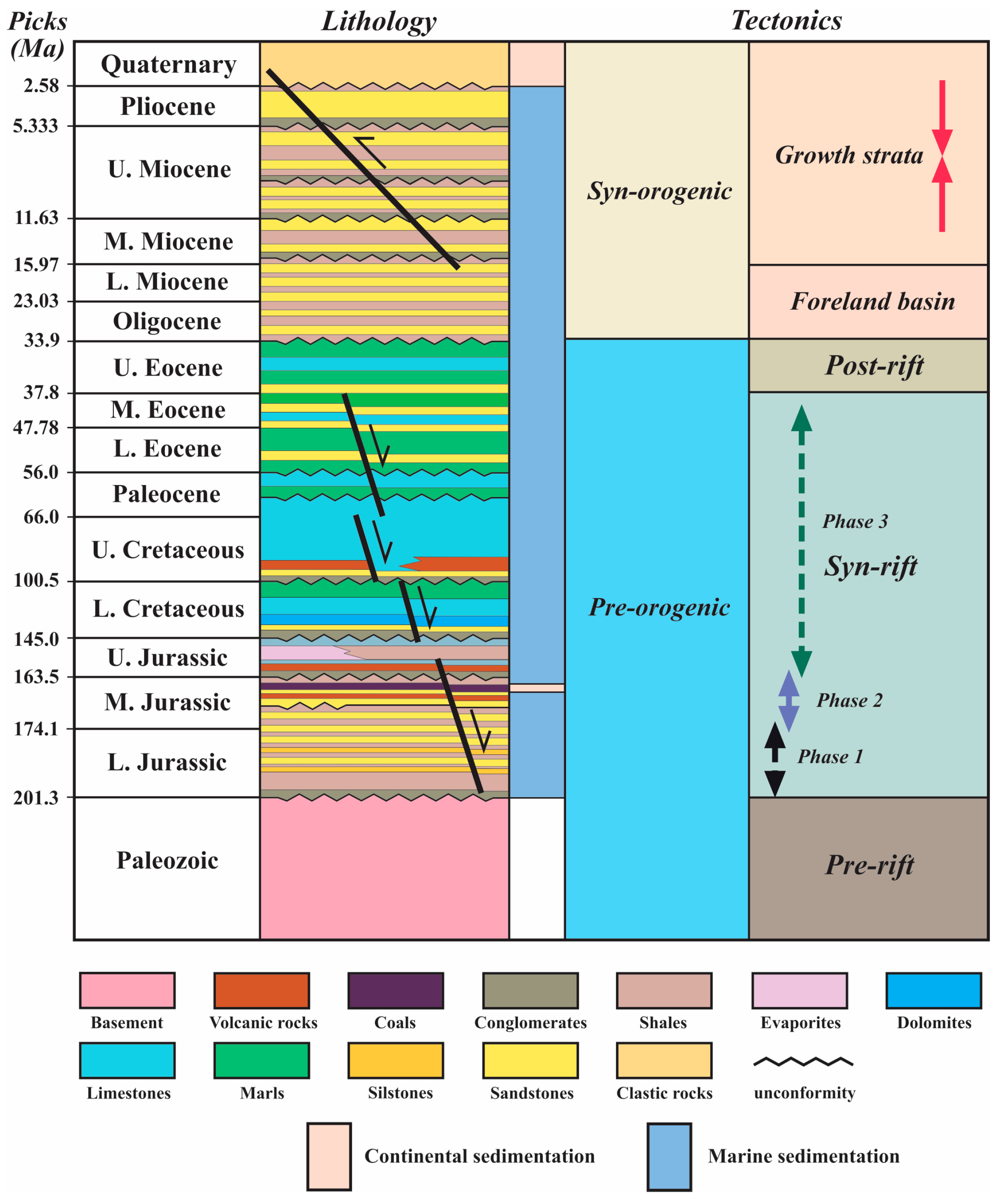
2. Geological Setting
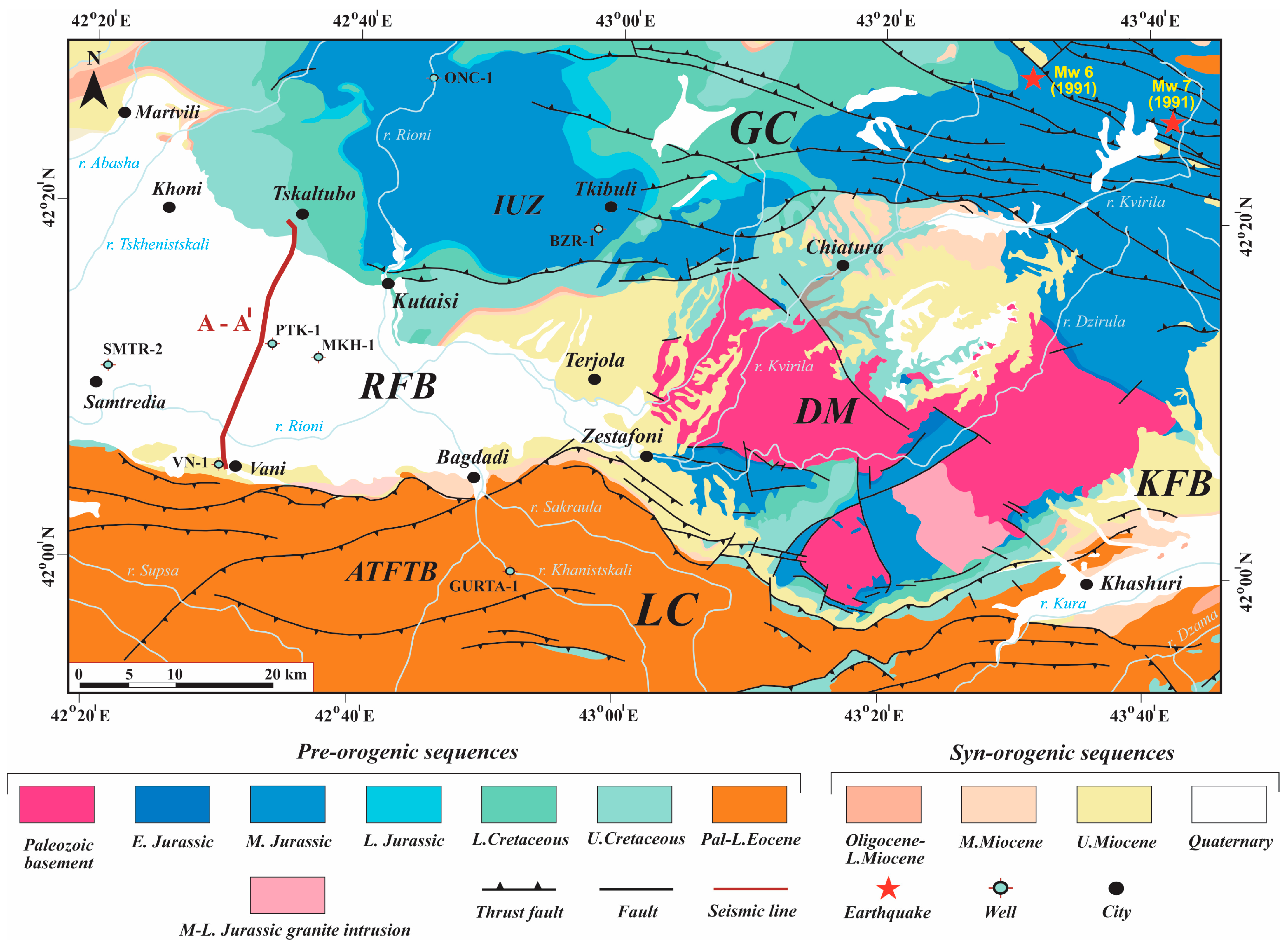
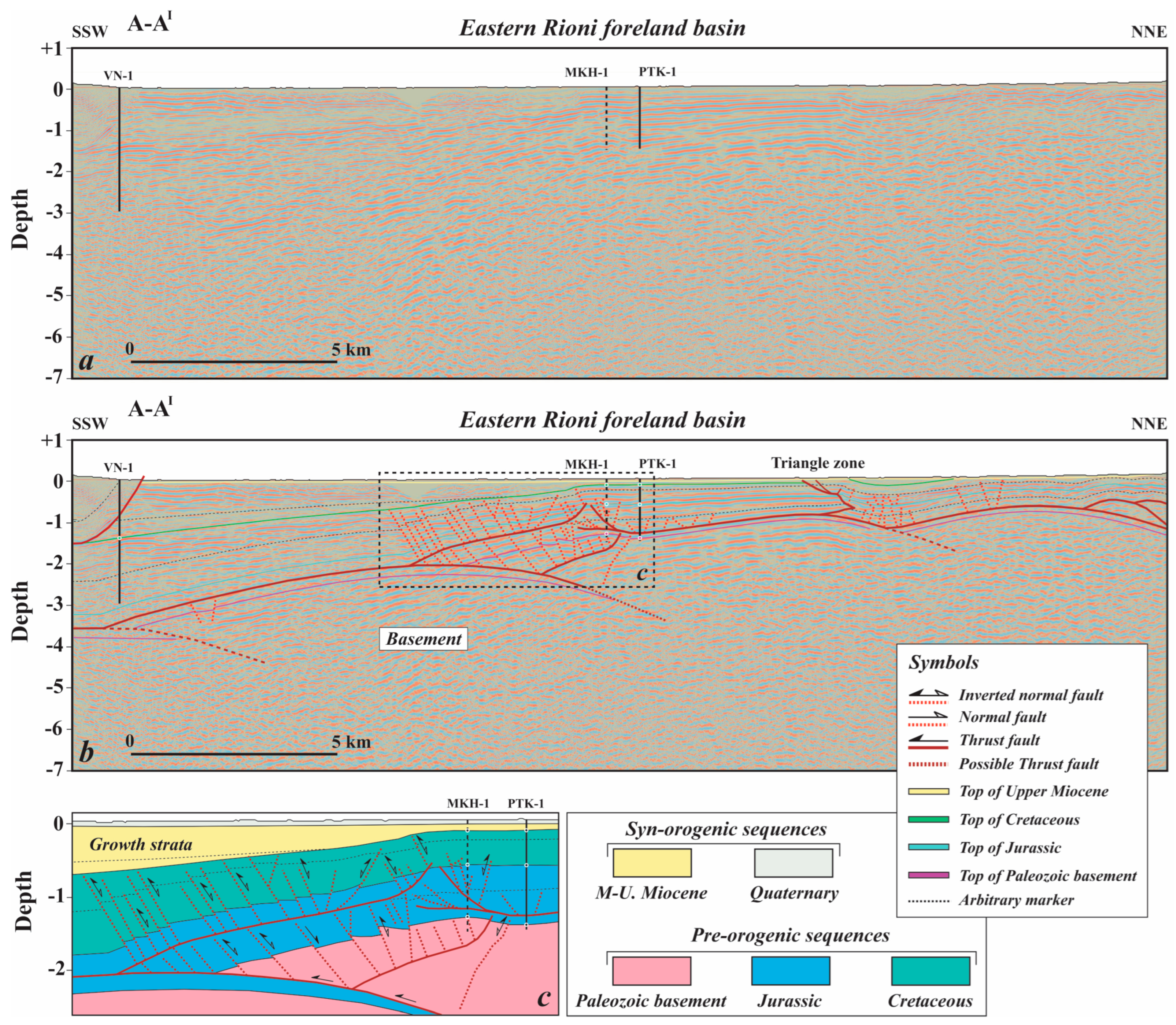
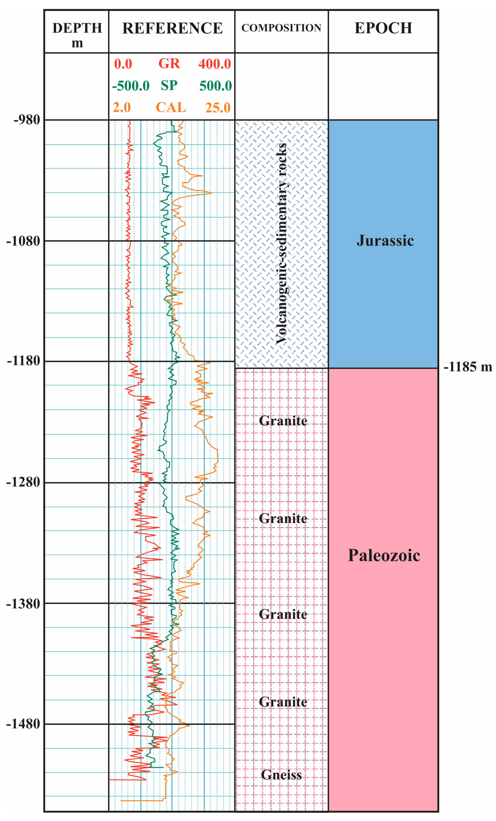
The geological structure of the RFB has been studied extensively, primarily due to hydrocarbon exploration activities, e.g., [15,26,27]. The RFB is characterized by a thin-skinned tectonic style, featuring fault-related folds and duplex structures [3]. Seismic profiles and deep well data have revealed two detachment levels in the western part of the RFB. Anticlines developed above the shallow detachment are expressed as south-vergent fault-propagation folds composed of Cretaceous to Neogene strata. The shallow detachment is located within the Upper Jurassic evaporites. South-vergent duplexes, formed from Lower to Middle Jurassic strata, are developed above the basal detachment situated in the Lower Jurassic shales. The formation of both fault-propagation folds and duplexes is associated with piggyback thrust sequences [3].
Based on its tectonic evolution, the RFB is divided into pre-orogenic and syn-orogenic sequences [3]. The sedimentary cover comprises a succession of marine (Jurassic–Pliocene) and continental (Quaternary) deposits, with a total thickness exceeding 4–6 km [3,15]. The stratigraphy of the RFB is illustrated in a tectonostratigraphic chart (Figure 3).
Figure 2. Geological map of study and surrounding area (modified from Adamia et al. [27]).
Geosciences 15 00291 g002
The pre-orogenic sequences of the RFB include pre-, syn-, and post-rift successions (Figure 3). The pre-rift succession is composed of Paleozoic granitic metamorphic rocks, e.g., [13,28]. The Paleozoic basement is exposed at the eastern margin of the RFB, in the area of the DM (Figure 2). In some locations, the Paleozoic basement is intruded by Middle to Upper Jurassic granites [13]. The syn-rift succession consists of Lower Jurassic to Middle Eocene shallow- and deep-marine sediments. The Jurassic sequence includes Lower Jurassic sandstones and shales (approx. 1500 m thick), Middle Jurassic debris flow deposits, shales, turbidites, calc-alkaline andesite-basalts, freshwater lacustrine coal-bearing sandy-argillaceous rocks, and Upper Jurassic evaporites, clastic rocks, and basalts [13,14,29,30]. The Lower Cretaceous succession, comprising conglomerates, turbidites, dolomites, limestones, and marls, unconformably overlies Upper Jurassic sediments. The Upper Cretaceous strata lie unconformably over the Lower Cretaceous units [13,25]. The combined Upper Cretaceous, Paleocene, and Eocene succession consists of mixed carbonate, siliciclastic, and volcaniclastic rocks, with a total thickness not exceeding 2000 m [15].
The syn-orogenic sequences of the RFB are composed of foreland basin (Oligocene–Lower Miocene) and syn-tectonic (Middle Miocene–Pleistocene) siliciclastic sediments [3]. The Oligocene–Lower Miocene sediments consist primarily of shales and sandstones and unconformably overlie the Upper Eocene post-rift deposits. The Middle to Upper Miocene and Pliocene–Pleistocene syn-tectonic succession is mainly composed of siliciclastic sediments, with a maximum thickness of approximately 2000 m [13].
The development of thrust-top basins in the western RFB indicates that compressional deformation began in the Middle Miocene. The formation of these basins was largely controlled by fault-propagation folding [3].

3. Data and Methods

Surface geological data were obtained from a 1:200,000-scale geological map of the study area [27] (Figure 2). This study is based on the structural interpretation of a 2D seismic profile acquired by Strait Oil and Gas Company in 2010 using vibrator methodology. The seismic data were processed and converted to depth using a velocity model derived from post-stack depth migration (PSDM) velocity analysis, conducted at the Geophysical Institute of Israel in 2011. To constrain the subsurface structure of the eastern Rioni Foreland Basin (RFB), we used a PSDM seismic profile (A–A1) and data from three boreholes: VN-1, MKH-1, and PTK-1. The VN-1 and PTK-1 wells were drilled during the Soviet period for geothermal investigation by the Georgian Geological Department, while MKH-1 was drilled in 2011 by Strait Oil and Gas Company. Drilling data from all three wells were integrated into the structural model presented in this study. Both MKH-1 and PTK-1 were drilled to penetrate the Paleozoic basement. Log data from MKH-1 is provided in Figure 4. The seismic profile A–A1 is oriented nearly perpendicular to the dominant structural trends of the eastern RFB and spans a total length of 26.7 km (Figure 2). We applied theories of contractional fault-related folding [31,32] to interpret the geometries of the fault-related folds and thrust wedges imaged in the seismic profile (Figure 5) and to construct a structural cross-section (Figure 6). Seismic interpretation and structural modeling were performed using Move 2018 structural geology modelling software.

4. Results and Discussion
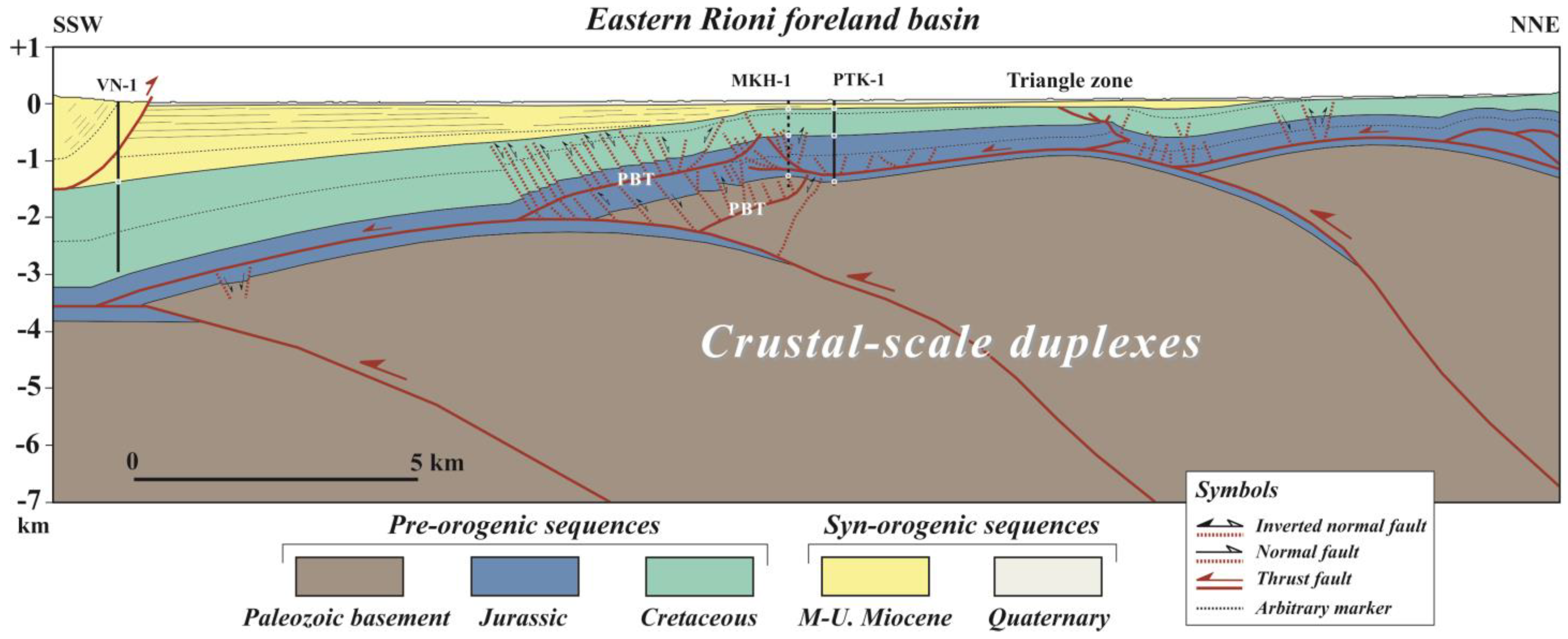
Seismic reflection data (A–AI) were acquired along a transect across the eastern RFB in western Georgia, providing structural information down to a depth of 7 km (Figure 5a,b). The seismic profile, integrated with deep borehole data and surface geological observations, has enabled the definition of the structural architecture of the eastern RFB. The profile (Figure 5a,b) reveals that the sedimentary cover in this area comprises an extensional basin succession ranging from the Jurassic to the Cretaceous. The seismic profile (A–AI) reveals the presence of normal faults within the pre-orogenic sedimentary strata (Figure 5b,c). These faults, inherited from the Middle Jurassic–Cretaceous, are associated with the syn-rift extensional phase, e.g., [3,32]. The seismic profile also shows that many of these normal faults were reactivated during later compressional deformation and now appear as reverse faults (Figure 5b,c).
The geometry of the sedimentary cover imaged in the seismic profile (A–AI) in the eastern RFB indicates the development of broad basement uplifts (Figure 5a,b). The maximum uplift of the Paleozoic basement is observed in the central and northern parts of the seismic profile, where the upper part of the Cretaceous sequence is eroded and unconformably overlain by Middle–Upper Miocene growth strata. The age of the growth strata from the seismic profile suggests that the initiation of thrusting in the eastern RFB began in the Middle Miocene (Figure 5b). These data are consistent with the results of detrital apatite fission-track data conducted in the KFB [7].
Although the seismic profile (A–AI) does not clearly image deep-seated thrusts within the basement, based on the geometry of the sedimentary cover and the basement top, we infer the involvement of crustal-scale duplexes (Figure 5b). To address this issue, we present a structural cross-section based on the seismic profile. The model integrates new field data from the eastern RFB, three oil wells, and seismic data to better constrain the subsurface geometry.
Figure 5. (a) Uninterpreted and (b) interpreted seismic profile A–AI. (c) Line-drawing fragment of seismic profile A–AI. The dark brown line marks the thrust faults. The dashed dark brown line marks the normal faults and reverse faults. Dashed lines represent the poorly constrained segments of the thrust faults. Location is shown in Figure 2.
Geosciences 15 00291 g005
Using seismic reflection data (Figure 5b) and the structural cross-section (Figure 6), we have identified six populations of tectonic structures in the eastern RFB: (1) normal faults, (2) reverse faults, (3) thrust faults, (4) duplexes, (5) triangle zone, and (6) crustal-scale duplexes. The structural cross-section reflects that the compressional deformations were controlled by the multi-level differential detachments. The shallow-level detachment developed between the Cretaceous and Middle Miocene strata and is represented by north-vergent thrust. The medium-level detachment in the lower Jurassic develops imbricate thrust faults and reverse faults. The deep-level detachment in the basement develops the duplexes (Figure 6). Thick-skinned structures are characterized by fault-bend folds that propagate into the sedimentary cover, primarily along detachment horizons within the Lower Jurassic shales. These structures form crustal-scale duplexes that accommodate and transfer deformation southward. Pre-existing, basement-involved extensional faults were inverted during compressional deformation, producing basement-cored uplifts that transferred thick-skinned shortening toward the thin-skinned structures detached above the basement.
The interpretation of the seismic profile (Figure 5b) and construction structural model across the seismic profile (A–AI) (Figure 6) was critical for identifying the structural style of deformation in the eastern RFB and its surrounding areas. The proposed structural model provides a framework for evaluating whether the observed duplexes represent a subsurface continuation of the DM to the west (Figure 6). Previous structural models of the eastern RFB and the DM have been oversimplified, e.g., [12,25,33,34]. Unlike the western RFB, the structural style of deformation in the eastern part (Figure 1 and Figure 2) remains poorly understood, representing a significant gap in our knowledge of the foreland basin deep structure. This gap largely stems from the limited availability of seismic profiles that would enable comprehensive structural correlations. Most existing studies of this region rely primarily on surface observations and borehole data, e.g., [12,26]. Various geological models across the DM differ markedly in their interpretations of structural style, e.g., [12,19,26,34,35], and the mechanism of uplift of the DM remains debated. To date, three main hypotheses have been proposed. The first suggests that the DM is an autochthonous basement block that extends westward beneath the RFB and southward beneath the KFB, e.g., [12,19,34]. The second hypothesis links the uplift of the DM to deep-seated transverse faulting, e.g., [35]. The third proposes that the DM is a structural wedge formed during the late Alpine orogeny [9].
The structural model (Figure 6) reveals that the uplift of the Paleozoic basement in the frontal part of the GC pro-wedge is the result of crustal-scale duplex stacking. Based on our preliminary data, we propose that this crustal-scale duplexing, active during the Middle Miocene to Pliocene, was the primary mechanism responsible for the separation of two distinct basins: the RFB to the west and the KFB to the south. It is well established that foreland basins can be classified into two end-member types [36,37]: (i) continuous foreland basins, which are typically associated with thin-skinned deformation, and (ii) broken foreland basins, which are characterized by thick-skinned deformation.
Figure 6. Structural model of seismic profile A–AI. Location is shown in Figure 2.
Geosciences 15 00291 g006
The wide variety of thrust geometries observed in foreland basins is typically associated with two end-member structural styles: thin-skinned and thick-skinned deformation [38,39]. Many foreland basins display a spectrum between these two styles and often undergo a transition in structural style over time, e.g., [38,39]. In the RFB of the western Caucasus, the deformation style transitions along a strike from a thin-skinned style in the west to a basement-involved, thick-skinned style toward the east (Figure 2). According to Horton et al. [40], the structural inheritance of basement normal faults in broken foreland basins is a key factor influencing the geometry and kinematics of crustal-scale duplexes or structural wedges during compressional deformation. These crustal-scale duplexes are typically rooted at mid-crustal or deeper levels [38,39]. Using the framework of end-member foreland basin styles [36,37,38,39,40], our preliminary results suggest that the collisional foreland basin located between the LC and GC orogens, and subdivided by the Dzirula Massif (DM) into the Rioni and Kura basins, represents a typical example of a broken foreland basin. As in other broken foreland basins, e.g., [40], the segmentation of the collisional foreland basin into the RFB to the west and the KFB to the south by the DM, within the LC–GC convergence zone, may be commonly associated with flat-slab continental subduction.
Compared to previously published models, our new structural interpretation provides a more comprehensive understanding of the deep structure of the eastern RFB. This work, based on the interpretation of the seismic profile across the eastern RFB, offers new insights for future investigations of the DM. Future studies can build on the findings of this research to provide a more comprehensive understanding of the structural evolution of the DM. Given its structural position in the frontal part of the GC pro-wedge, the documented crustal-scale duplex stacking presents a valuable opportunity to study the geometry of the collision zone between the LC and GC orogens.

5. Conclusions

We have documented the subsurface structural geology of the eastern RFB in western Georgia. The seismic reflection profile (A–AI) and structural model, oriented from SSW to NNE, reveal two primary structural styles: (1) thin-skinned thrust fault systems, and (2) basement-involved duplexes or thick-skinned fault-bend fold structural wedges. Within the thin-skinned thrust fault systems, we have identified several populations of tectonic structures in the eastern RFB: (1) normal faults, (2) reverse faults, (3) thrust faults, (4) duplexes, and (5) triangle zone. The formation of crustal-scale duplexes is interpreted as the result of the reactivation of pre-existing normal faults during compressional deformation. The age of the growth strata from the seismic profile suggests that the initiation of thrusting in the eastern RFB began in the Middle Miocene, and compressional deformations were controlled by the multi-level differential detachments. Our analysis suggests that the crustal-scale duplexes imaged in the structural model represent a westward continuation of the DM. The uplift of this crystalline massif, located in the frontal part of the GC pro-wedge, is attributed to the stacking of crustal-scale fault-bend fold duplexes, exhumed as part of a broken foreland basin.

Author Contributions

Conceptualization, V.A.; methodology, V.A., O.E. and A.R.; software, V.A.; O.E. and A.R.; validation, V.A., O.E., N.K., T.B., R.C., A.G., G.M. and A.R.; formal analysis, V.A., O.E., N.K. and T.B.; investigation, V.A., O.E., N.K. and T.B.; resources, V.A.; data collection, A.R.; data curation, V.A., O.E., N.K. and T.B.; writing—original draft preparation, V.A., O.E., N.K. and T.B.; writing—review and editing, V.A., O.E., N.K., T.B., R.C., A.G., G.M. and A.R.; supervision, V.A.; project administration, V.A., O.E. and N.K.; funding acquisition, V.A., O.E., N.K. and T.B. All authors have read and agreed to the published version of the manuscript.

Funding

The work was supported by the Shota Rustaveli National Science Foundation of Georgia (SRNSFG; 2023-2025, grant no. FR-21-26377).

Data Availability Statement

The original contributions presented in this study are included in the article. Further inquiries can be directed to the corresponding author.

Acknowledgments

We are sincerely grateful to the Georgian State Agency of Oil and Gas for providing the seismic profile used in this study. The authors also thank the editors Andjela Jovanovic, and Gianluca Groppelli, and the reviewers for their valuable comments and constructive suggestions.

Conflicts of Interest

The authors declare no conflict of interest.

Abbreviations

The following abbreviations are used in this manuscript:
ATFTBAchara-Trialeti fold-and-thrust belt
AFBAraks foreland basin
DMDzirula massif
EPEastern Pontides
KFBKura foreland basin
GCGreater Caucasus
IUZImereti Uplift Zone
KBKuban Basin
LCLesser Caucasus
RFBRioni foreland basin
TBTerek Basin
PBTPassive-back thrust

References

  1. Sosson, M.; Rolland, Y.; Müller, C.; Danelian, T.; Melkonyan, R.; Kekelia, S.; Adamia, S.; Babazadeh, V.; Kangarli, T.; Avagyan, A.; et al. Subductions, obduction and collision in the Lesser Caucasus (Armenia, Azerbaijan, Georgia), new insights. Geol. Soc. Lond. Spec. Publ. 2010, 340, 329–352. [Google Scholar] [CrossRef]
  2. Cavazza, W.; Albino, I.; Galoyan, G.; Zattin, M.; Cattò, S. Continental accretion and incremental deformation in the thermochronologic evolution of the Lesser Caucasus. Geosci. Front. 2019, 10, 2189–2202. [Google Scholar] [CrossRef]
  3. Alania, V.; Melikadze, G.; Pace, P.; Fórizs, I.; Beridze, T.; Enukidze, O.; Giorgadze, A.; Razmadze, A. Deformation structural style of the Rioni foreland fold-and-thrust belt, western Greater Caucasus: Insight from the balanced cross-section. Front. Earth Sci. 2022, 10, 10968386. [Google Scholar] [CrossRef]
  4. Nemcok, M.; Glonti, B.; Yukler, A.; Marton, B. Development history of the foreland plate trapped between two converging orogens: Kura Valley, Georgia, case study. Geol. Soc. Lond. Spec. Publ. 2013, 377, 159–188. [Google Scholar] [CrossRef]
  5. Forte, A.M.; Cowgill, E.S.; Whipple, K.X. Transition from a singly vergent to a doubly vergent wedge in a young orogen: The Greater Caucasus. Tectonics 2014, 33, 2077–2101. [Google Scholar] [CrossRef]
  6. Alania, V.; Chabukiani, A.; Chagelishvili, R.; Enukidze, O.; Gogrichiani, K.; Razmadze, A.; Tsereteli, N. Growth structures, piggyback basins and growth strata of Georgian part of Kura foreland fold and thrust belt: Implication for Late Alpine kinematic evolution. Geol. Soc. Lond. Spec. Publ. 2017, 428, 171–185. [Google Scholar] [CrossRef]
  7. Gusmeo, T.; Cavazza, C.; Alania, V.; Enukidze, O.; Zattin, M.; Corrado, S. Structural inversion of back-arc basins-The Neogene Adjara-Trialeti fold-and-thrust belt (SW Georgia) as a far-field effect of the Arabia-Eurasia collision. Tectonophysics 2021, 803, 228702. [Google Scholar] [CrossRef]
  8. Mosar, J.; Mauvilly, J.; Koiava, K.; Gamkrelidze, I.; Enna, N.; Lavrishev, V.; Kalberguenova, V. Tectonics in the Greater Caucasus (Georgia–Russia): From an intracontinental rifted basin to a doubly verging fold-and-thrust belt. Mar. Pet. Geol. 2022, 140, 105630. [Google Scholar] [CrossRef]
  9. Alania, V.; Enukidze, O.; Tevzadze, N. Some problems of Caucasus tectonics: New insight and data from the structural cross-sections. In Proceedings of the Exploration and Production in the Black Sea, Caucasus, and Caspian Region, AAPG GTW Conference, Batumi, Georgia, 18–19 September 2019. [Google Scholar]
  10. Sobornov, K.O. Lateral variations in structural styles of tectonic wedging in the northeastern Caucasus, Russia. Bull. Can. Petr. Geol. 1996, 44, 385–399. [Google Scholar]
  11. Sobornov, K. Structures and evolution of the Terek-Caspian fold-and-thrust belt: New insight from regional seismic data. J. Petrol. Geol. 2021, 44, 259–286. [Google Scholar] [CrossRef]
  12. Banks, C.J.; Robinson, A.G.; Williams, M.P. Structure and regional tectonics of the Achara-Trialet fold belt and the adjacent Rioni and Kartli foreland basins, Republic of Georgia. Am. Assoc. Pet. Geol. Mem. 1997, 68, 331–346. [Google Scholar]
  13. Adamia, S.; Zakariadze, G.; Chkhotua, T.; Sadradze, N.; Tsereteli, N.; Chabukiani, A.; Gventsadze, A. Geology of the Caucasus: A review. Turk. J. Earth Sci. 2011, 20, 489–544. [Google Scholar] [CrossRef]
  14. McCann, T.; Chalot-Prat, F.; Saintot, A. The early Mesozoic evolution of the western Greater Caucasus (Russia): Triassic-Jurassic sedimentary and magmatic history. Geol. Soc. Lond. Spec. Publ. 2010, 340, 181–238. [Google Scholar] [CrossRef]
  15. Tari, G.; Vakhania, D.; Tatishvili, G.; Mikeladze, V.; Gogritchiani, K.; Vacharadze, S.; Mayer, J.; Sheya, C.; Siedl, W.; Banon, J.J.; et al. Stratigraphy, structure and petroleum exploration play types of the Rioni Basin, Georgia. Geol. Soc. Lond. Spec. Publ. 2018, 464, 403–438. [Google Scholar] [CrossRef]
  16. Cowgill, E.; Forte, A.M.; Niemi, N.; Avdeev, B.; Tye, A.; Trexler, C.; Javakhishvili, Z.; Elashvili, M.; Godoladze, T. Relict basin closure and crustal shortening budgets during continental collision: An example from Caucasus sediment provenance. Tectonics 2016, 35, 2918–2947. [Google Scholar] [CrossRef]
  17. Trexler, C.C.; Cowgill, E.; Spencer, J.Q.G.; Godoladze, T. Rate of active shortening across the southern thrust front of the Greater Caucasus in western Georgia from kinematic modeling of folded river terraces above a listric thrust. Earth Planet. Sci. Lett. 2020, 544, 116362. [Google Scholar] [CrossRef]
  18. Eppelbaum, L.V.; Khesin, B.E. Geophysical Studies in the Caucasus; Springer: Heidelberg, Germany, 2012. [Google Scholar]
  19. Ruppel, C.; McNutt, M. Regional compensation of the Greater Caucasus mountains based on an analysis of Bouguer gravity data. Earth Planet. Sci. Lett. 1990, 98, 360–379. [Google Scholar] [CrossRef]
  20. Trifonov, V.G.; Sokolov, S.Y.; Sokolov, S.A.; Hessami, K. Mesozoic-Cenozoic Structure of the Black Sea-Caucasus-Caspian Region and Its Relationships with the Upper Mantle Structure. Geotectonics 2020, 54, 331–355. [Google Scholar] [CrossRef]
  21. Tibaldi, A.; Tsereteli, N.; Varazanashvili, O.; Babayev, G.; Barth, A.; Mumladze, T.; Bonali, F.; Russo, E.; Kadirov, F.; Yetirmishli, G.; et al. Active stress field and fault kinematics of the Greater Caucasus. J. Asian Earth Sci. 2020, 188, 104108. [Google Scholar] [CrossRef]
  22. Triep, E.G.; Abers, G.A.; Lerner-Lam, A.L.; Mishatkin, V.; Zakharchenko, N.; Starovoit, O. Active thrust fault of the Greater Caucasus: The April 29, 1991, Racha earthquake sequence and its tectonic implications. J. Geophys. Res. 1995, 100, 4011–4033. [Google Scholar] [CrossRef]
  23. Tan, O.; Taymaz, T. Active tectonics of the Caucasus: Earthquake source mechanisms and rupture histories obtained from inversion of teleseismic body waveforms. Geol. Soc. Am. Spec. Paper 2006, 409, 531–578. [Google Scholar]
  24. Sokhadze, G.; Floyd, M.; Godoladze, T.; King, R.; Cowgill, E.S.; Javakhishvili, Z. Active convergence between the lesser and greater Caucasus in Georgia: Constraints on the tectonic evolution of the Lesser-Greater Caucasus continental collision. Earth Planet. Sci. Lett. 2018, 481, 154–161. [Google Scholar] [CrossRef]
  25. Reilinger, R.; McClusky, S.; Vernant, P.; Lawrence, S.; Ergintav, S.; Cakmak, R.; Ozener, H.; Kadirov, F.; Guliev, I.; Stepanyan, R.; et al. GPS constraints on continental deformation in the Africa–Arabia–Eurasia continental collision zone and implications for the dynamics of plate interactions. J. Geophys. Res. 2006, 111, B05411. [Google Scholar] [CrossRef]
  26. Vakhania, D. Geodynamic evolution of oil and gas deposit generation within the Western (Kolkhida) zone of the sinking Transcaucasian intermountain region. Georgian Oil Gas 2008, 22, 108–130. [Google Scholar]
  27. Adamia, S.; Sadradze, N.; Alania, V.; Talakhadze, G.; Khmaladze, K. Geology of Lithosphere of the Georgia, Deep Structure, Geodynamics and Evolution; Diagrama Press: Tbilisi State University: Tbilisi, Georgia, 2020. [Google Scholar]
  28. Zakariadze, G.; Dilek, Y.; Adamia, S.; Oberhänsli, R.; Karpenko, S.; Bazylev, B.; Solov’eva, N. Geochemistry and geochronology of the Neoproterozoic Pan-African Transcaucasian Massif (Republic of Georgia) and implications for island arc evolution of the late Precambrian Arabian–Nubian Shield. Gondwana Res. 2007, 11, 92–108. [Google Scholar] [CrossRef]
  29. Beridze, M. Geosynclinal Sedimentary Lithogenesis as Exemplified by Early Mesozoic Formations of the Greater Caucasus; Metsniereba: Tbilisi, Georgia, 1983. [Google Scholar]
  30. Geological Report of MKH-1 Oil Well; Strait Oil and Gas: Tbilisi, Georgia, 2011.
  31. Shaw, J.H.; Connors, C.D.; Suppe, J. Seismic Interpretation of Contractional Fault-Related Folds; AAPG Studies in Geology 53; AAPG: Tulsa, OK, USA, 2005. [Google Scholar]
  32. Brandes, C.; Tanner, D.C. Fault-related folding: A review of kinematic models and their application. Earth-Sci. Rev. 2014, 138, 352–370. [Google Scholar] [CrossRef]
  33. Vincent, S.J.; Braham, W.; Lavrishchev, V.A.; Maynard, J.R.; Harland, M. The formation and inversion of the western Greater Caucasus Basin and the uplift of the western Greater Caucasus: Implications for the wider Black Sea region. Tectonics 2016, 35, 2948–2962. [Google Scholar] [CrossRef]
  34. Khain, V. Structure and main stages in the tectono-magmatic development of the Caucasus: An attempt at geodynamic interpretation. Am. J. Sci. 1975, 275, 131–156. [Google Scholar]
  35. Basheleishvili, L.B. Structural Associations of the Basement and Sedimentary Cover of the Georgian Part of the Caucasus. In Basement Tectonics; Sinha, A.K., Ed.; Springer: Dordrecht, The Netherlands, 1999; pp. 25–32. [Google Scholar]
  36. Strecker, M.R.; Hilley, G.E.; Bookhagen, B.; Sobel, E.R. Structural, geomorphic, and depositional characteristics of contiguous and broken foreland basins: Examples from the eastern flanks of the Central Andes in Bolivia and NW Argentina. In Tectonics of Sedimentary Basins: Recent Advances; Cathy Busby, C., Azor, A., Eds.; Blackwell Publishing: Chichester, UK, 2012; pp. 508–521. [Google Scholar]
  37. Horton, B.K. Sedimentary record of Andean Mountain building. Earth-Sci. Rev. 2018, 178, 279–309. [Google Scholar] [CrossRef]
  38. Lacombe, O.; Bellahsen, N. Thick-skinned tectonics and basement-involved fold-thrust belts: Insights from selected Cenozoic orogens. Geol. Mag. 2016, 153, 763–810. [Google Scholar] [CrossRef]
  39. Pfiffner, O.A. Thick-skinned and thin-skinned tectonics: A global perspective. Geosciences 2017, 7, 71. [Google Scholar] [CrossRef]
  40. Horton, B.K.; Capaldi, T.N.; Mackaman-Lofland, C.; Perez, N.D.; Bush, M.A.; Fuentes, F.; Constenius, K.N. Broken foreland basins and the influence of subduction dynamics, tectonic inheritance, and mechanical triggers. Earth-Sci. Rev. 2022, 234, 104193. [Google Scholar] [CrossRef]
Figure 3. Tectonostratigraphic chart of the RFB and surrounding area (modified from Alania et al. [3]).
Geosciences 15 00291 g003
Figure 4. MKH–1 drilling target, showing composition, Gamma Ray (GR), Spontaneous Potential (SP), and Caliper (CAL) logs (fragment) [30]. Location is shown in Figure 2.
Geosciences 15 00291 g004
Disclaimer/Publisher’s Note: The statements, opinions and data contained in all publications are solely those of the individual author(s) and contributor(s) and not of MDPI and/or the editor(s). MDPI and/or the editor(s) disclaim responsibility for any injury to people or property resulting from any ideas, methods, instructions or products referred to in the content.

