
Relative Sea Level Changes in the Bay of Maladroxia, Southwestern Sardinia, and Their Implications for the Pre- and Protohistoric Cultures


Abstract
1. Introduction
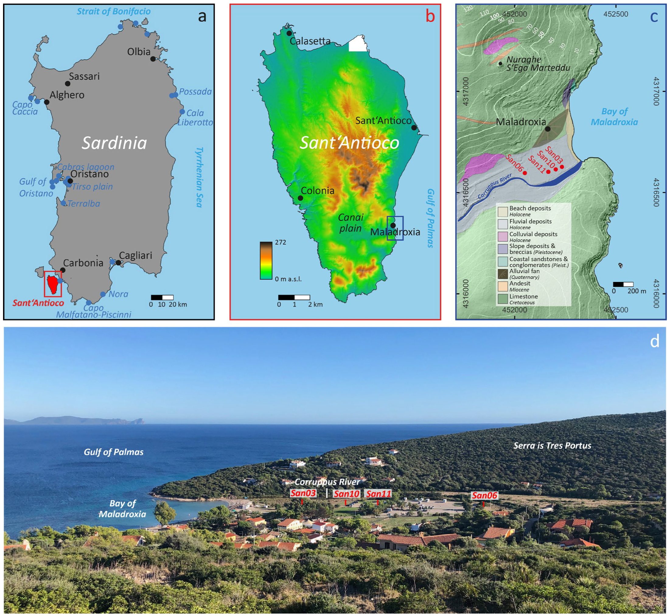
2. Study Area
2.1. Physio-Geographical Setting
2.2. Archaeological Setting
3. Methods
3.1. Field Work
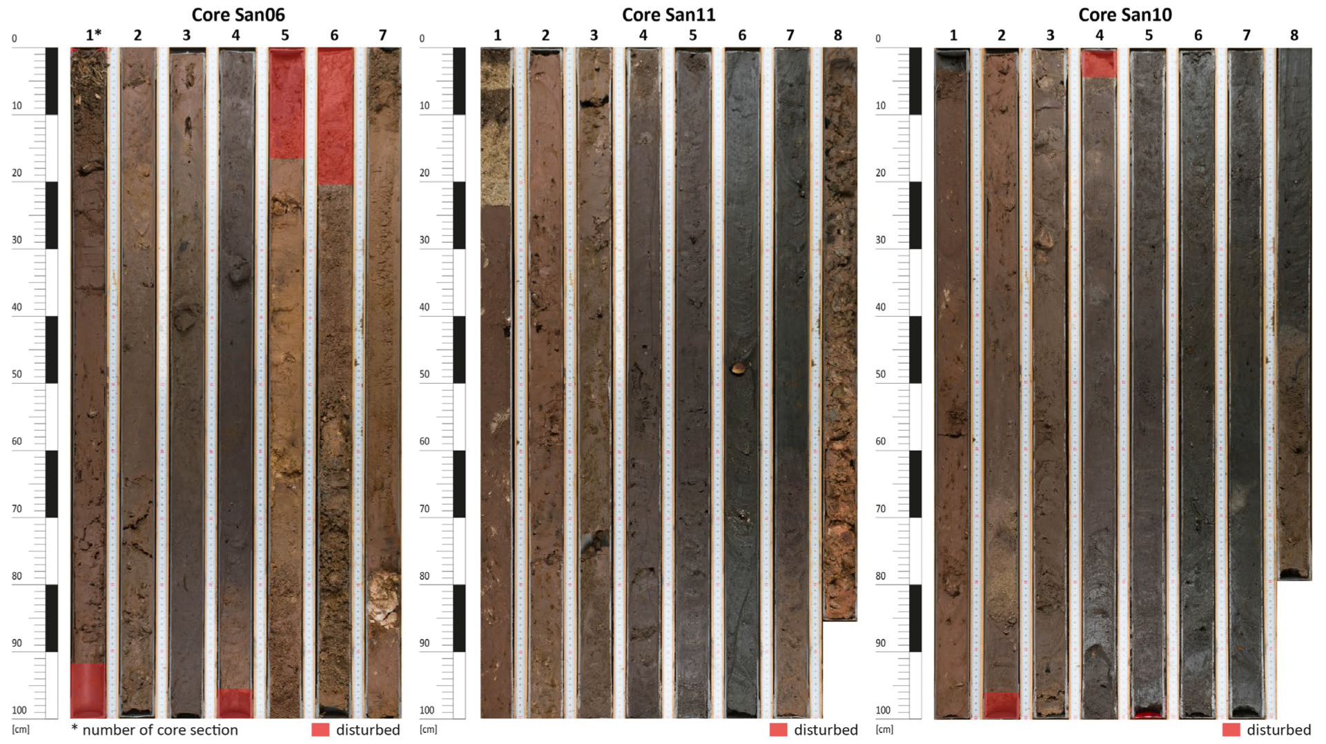
3.2. Sampling and Description
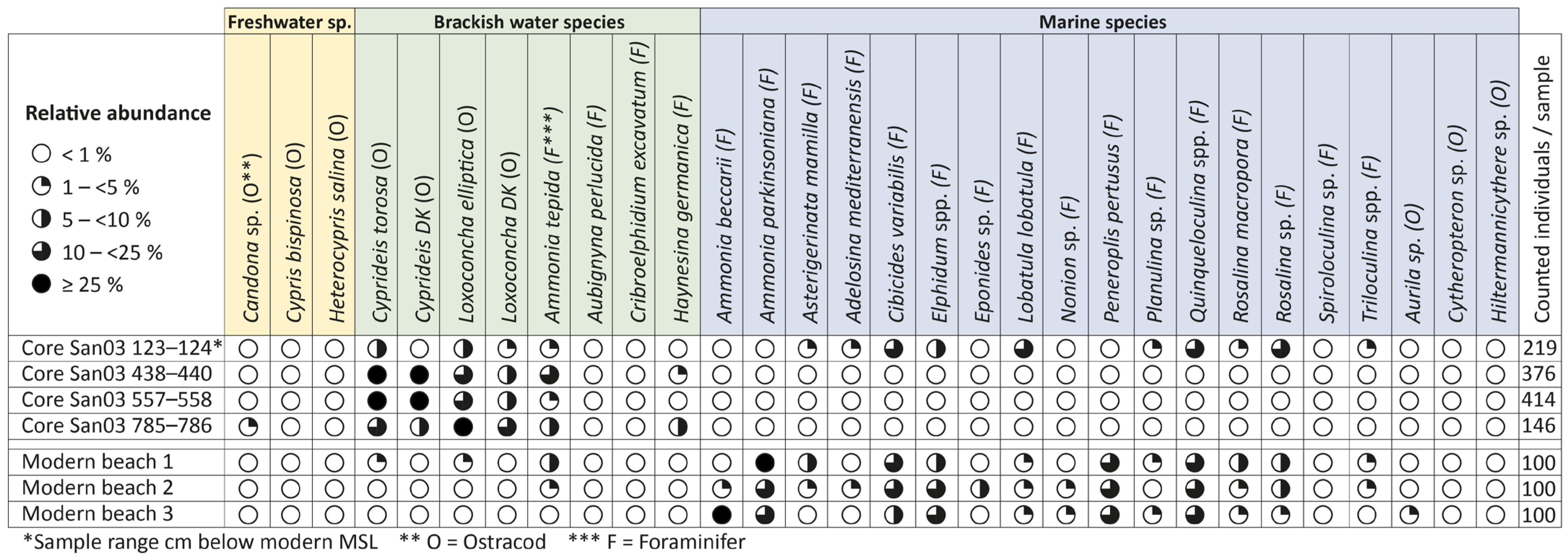
3.3. Microfossil Analysis
3.4. Radiocarbon Dating
3.5. Relative Sea Level Reconstruction
4. Results

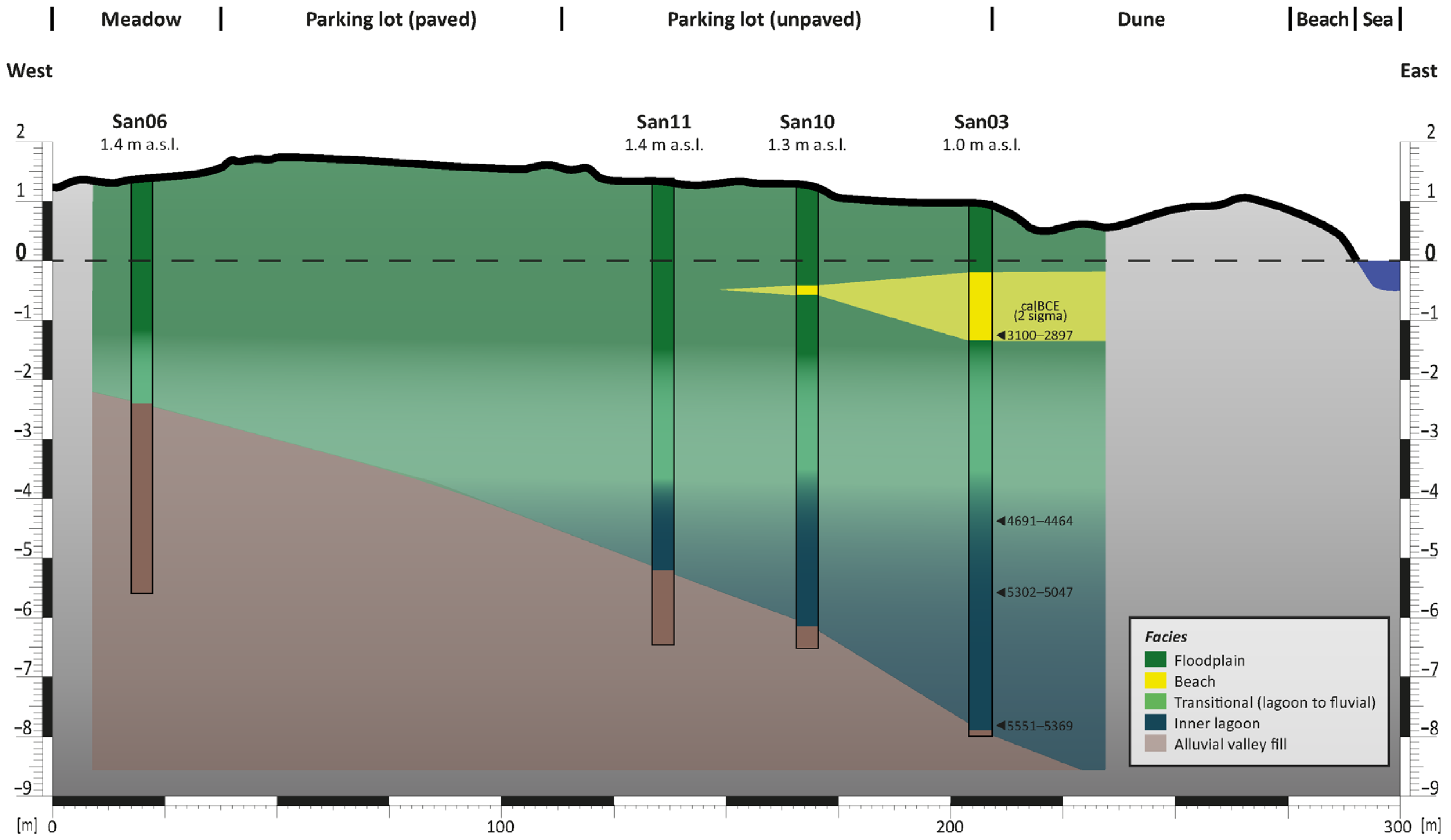
4.1. Facies Description
4.1.1. Alluvial Deposits
4.1.2. Inner Lagoon Deposits
4.1.3. Transitional Deposits
4.1.4. Beach Deposits
4.1.5. Fluvial Deposits
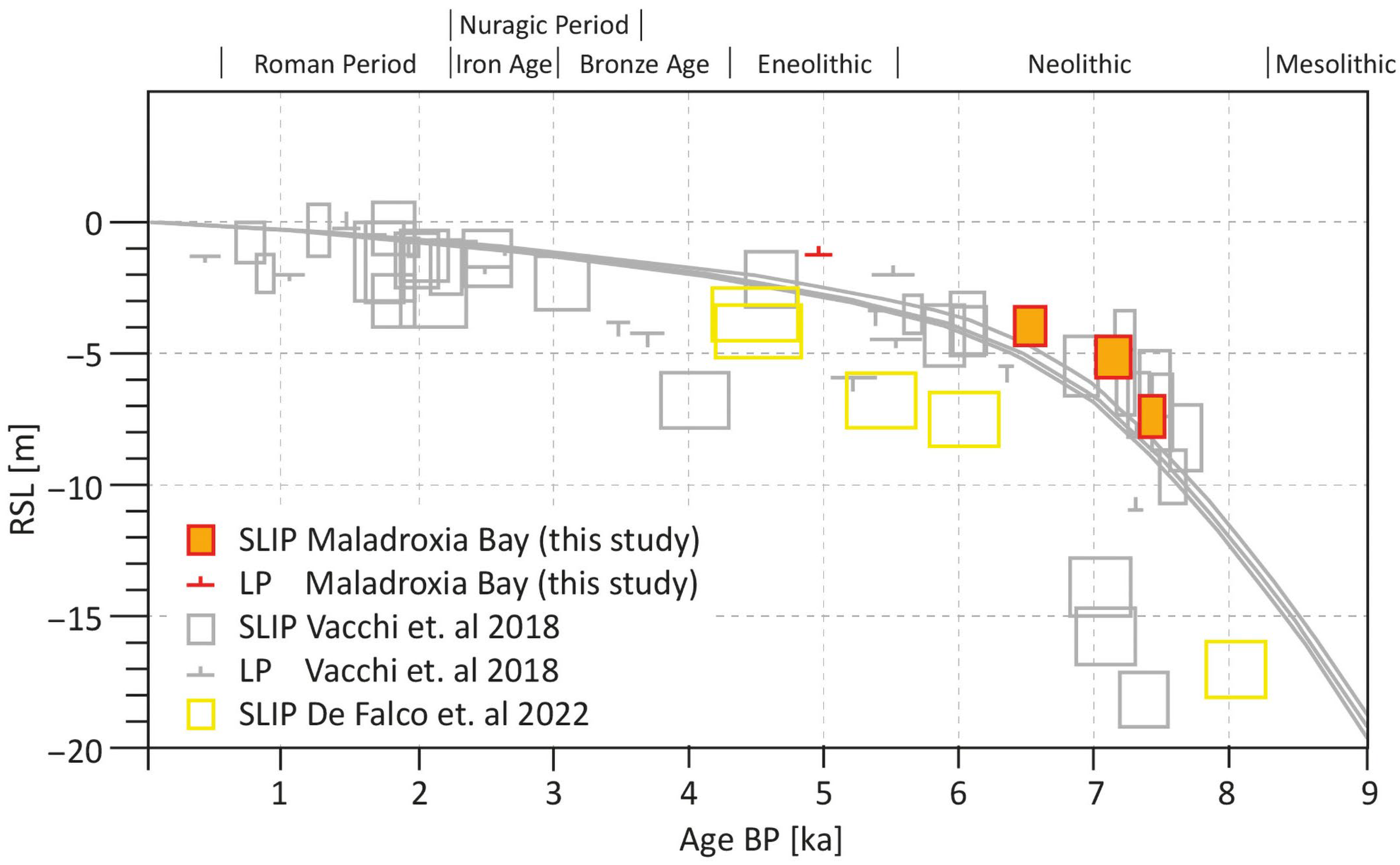
4.2. Sea Level Index Points and Limiting Points

| Mean Depth b.s. | Type | RSLi * | Total Vertical Error Ei ** | Ai Below MSL | RWLi | Error | |||||
|---|---|---|---|---|---|---|---|---|---|---|---|
| e1 | e2 | e3 | e4 | e5 | e6 | ||||||
| Indicative Range *** | Elevation Error **** | Core Stretching/Shortening Error *** | Sample Thickness Uncertainty | Tidal Uncertainty *** | Angle Error | ||||||
| [m] | [m] | [m] | [m] | [m] | [m] | ||||||
| 2.235 | LP | 1.235 | 0.52 | MSL | above MSL | 0.5 | 0.15 | 0.01 | 0.1 | 0.02235 | |
| 5.39 | SLIP | 3.89 | 0.73 | 4.39 | −0.5 | 0.5 | 0.5 | 0.15 | 0.01 | 0.1 | 0.0539 |
| 6.575 | SLIP | 5.075 | 0.78 | 5.575 | −0.5 | 0.5 | 0.5 | 0.15 | 0.005 | 0.1 | 0.06575 |
| 8.855 | SLIP | 7.355 | 0.79 | 7.855 | −0.5 | 0.5 | 0.5 | 0.15 | 0.005 | 0.1 | 0.08855 |
5. Discussion
5.1. Sea Level Rise in the Sardinian Context
5.2. Environmental Changes in the Bay of Maladroxia

5.3. Implications for the Pre- and Protohistory
6. Conclusions
Author Contributions
Funding
Data Availability Statement
Acknowledgments
Conflicts of Interest
Abbreviations
| AMS | Accelerator mass spectrometry |
| BCE | Before common era |
| BP | Before present |
| cal | Calibrated |
| CE | Common era |
| IR | Indicative range |
| LP | Limiting point |
| MIS | Marine isotope stage |
| MSL | Mean sea level |
| RWL | Reference water level |
| SLIP | Sea level index point |
References
- Benjamin, J.; Rovere, A.; Fontana, A.; Furlani, S.; Vacchi, M.; Inglis, R.H.; Galili, E.; Antonioli, F.; Sivan, D.; Miko, S.; et al. Late Quaternary Sea-Level Changes and Early Human Societies in the Central and Eastern Mediterranean Basin: An Interdisciplinary Review. Quat. Int. 2017, 449, 29–57. [Google Scholar] [CrossRef]
- Brückner, H.; Kelterbaum, D.; Marunchak, O.; Porotov, A.; Vött, A. The Holocene Sea Level Story since 7500 BP–Lessons from the Eastern Mediterranean, the Black and the Azov Seas. Quat. Int. 2010, 225, 160–179. [Google Scholar] [CrossRef]
- Lambeck, K. Sea-Level Change in the Mediterranean Sea since the LGM: Model Predictions for Tectonically Stable Areas. Quat. Sci. Rev. 2005, 24, 1969–1988. [Google Scholar] [CrossRef]
- Fontana, A.; Vinci, G.; Tasca, G.; Mozzi, P.; Vacchi, M.; Bivi, G.; Salvador, S.; Rossato, S.; Antonioli, F.; Asioli, A.; et al. Lagoonal Settlements and Relative Sea Level during Bronze Age in Northern Adriatic: Geoarchaeological Evidence and Paleogeographic Constraints. Quat. Int. 2017, 439, 17–36. [Google Scholar] [CrossRef]
- Melis, R.T.; Rita, F.D.; French, C.; Marriner, N.; Montis, F.; Serreli, G.; Sulas, F.; Vacchi, M. 8000 years of Coastal Changes on a Western Mediterranean Island: A Multiproxy Approach from the Posada Plain of Sardinia. Mar. Geol. 2018, 403, 93–108. [Google Scholar] [CrossRef]
- Antonioli, F.; Anzidei, M.; Lambeck, K.; Auriemma, R.; Gaddi, D.; Furlani, S.; Orrù, P.; Solinas, E.; Gaspari, A.; Karinja, S.; et al. Sea-Level Change during the Holocene in Sardinia and in the Northeastern Adriatic (Central Mediterranean Sea) from Archaeological and Geomorphological Data. Quat. Sci. Rev. 2007, 26, 2463–2486. [Google Scholar] [CrossRef]
- Marsico, A.; Lisco, S.; Presti, V.L.; Antonioli, F.; Amorosi, A.; Anzidei, M.; Deiana, G.; De Falco, G.; Fontana, A.; Fontolan, G.; et al. Flooding Scenario for Four Italian Coastal Plains Using Three Relative Sea Level Rise Models. J. Maps 2017, 13, 961–967. [Google Scholar] [CrossRef]
- Vacchi, M.; Ghilardi, M.; Melis, R.T.; Spada, G.; Giaime, M.; Marriner, N.; Lorscheid, T.; Morhange, C.; Burjachs, F.; Rovere, A. New Relative Sea-Level Insights into the Isostatic History of the Western Mediterranean. Quat. Sci. Rev. 2018, 201, 396–408. [Google Scholar] [CrossRef]
- Orrù, P.; Solinas, E.; Puliga, G.; Deiana, G. Palaeo-Shorelines of the Historic Period, Sant’Antioco Island, South-Western Sardinia (Italy). Quat. Int. 2011, 232, 71–81. [Google Scholar] [CrossRef]
- von Rüden, C.; Klingenberg, T.; Usadel, M. Grutt’i Acqua and Its Hinterland. Some Preliminary Insights into the Exploration of the Microregion of Sant’Antioco. In Proceedings of the Fifth Festival of the Nuragic Civilization (Orroli, Cagliari); Perra, M., LoSchiavo, F., Eds.; Arkadia Editore: Cagliari, Italy, 2023; pp. 23–45. [Google Scholar]
- Carmignani, L.; Oggiano, G.; Funedda, A.; Conti, P.; Pasci, S. The Geological Map of Sardinia (Italy) at 1:250,000 Scale. J. Maps 2016, 12, 826–835. [Google Scholar] [CrossRef]
- Lustrino, M.; Morra, V.; Fedele, L.; Franciosi, L. Beginning of the Apennine Subduction System in Central Western Mediterranean: Constraints from Cenozoic “Orogenic” Magmatic Activity of Sardinia, Italy. Tectonics 2009, 28, TC5016. [Google Scholar] [CrossRef]
- Ferranti, L.; Antonioli, F.; Mauz, B.; Amorosi, A.; Pra, G.D.; Mastronuzzi, G.; Monaco, C.; Orrù, P.; Pappalardo, M.; Radtke, U.; et al. Markers of the Last Interglacial Sea-Level High Stand along the Coast of Italy: Tectonic Implications. Quat. Int. 2006, 145, 30–54. [Google Scholar] [CrossRef]
- Pungetti, G.; Marini, A.; Vogiatzakis, I.N. Sardinia. In Mediterranean Island Landscapes; Vogiatzakis, I.N., Pungetti, G., Mannion, A.M., Eds.; Landscape Series; Springer: Dordrecht, The Netherlands, 2008; pp. 143–169. ISBN 978-90-481-7271-9. [Google Scholar]
- Soldati, M.; Marchetti, M. Landscapes and Landforms of Italy; Soldati, M., Marchetti, M., Eds.; World Geomorphological Landscapes; Springer: Cham, Switzerland, 2017; ISBN 3319261940. [Google Scholar]
- Vacca, G. Tracce. Il Primo Popolamento Dell’isola Di Sant’Antioco; Cagliaritana, C.U.E., Ed.; University Press-Archeologia: Cagliari, Italy, 2009; ISBN 8884675340. [Google Scholar]
- Usai, L.S. Antioco. Area Del Cronicario. Campagne Di Scavo 1983-86. La Ceramica Preistorica Dell’area Del Cronicario. Rev. Studi Fenici 1990, 18, 103–123. [Google Scholar]
- Marras, V. Emergenze Archeologiche Extraurbane Di Età Preistorica Nel Territorio Del Comune Di Sant’Antioco. Quad. Soprintend. Prov. Cagliari Oristano 1996, 13, 87–107. [Google Scholar]
- Bartoloni, P. Porti e Approdi Dell’antica Sulcis. In Naves Plenis Velis Euntes; Mastino, A., Spanu, P.G., Zucca, R., Eds.; Carocci: Roma, Italy, 2009; pp. 178–192. ISBN 978-8843048564. [Google Scholar]
- Kretschmer, K. Die Italienischen Portolane des Mittelalters: Ein Beitrag zur Geschichte der Kartographie und Nautik; Reprint of the Berlin 1909 Edition; Olms: Hildesheim, Germany, 1962. [Google Scholar]
- Schlöffel, M.; Schneider, S.; Schütt, B. Fluvial Dynamics and Phases of Landscape Development in the Bronze Age Settlement Area of the Sambek Valley (Northeastern Hinterland of the Sea of Azov). Mediterr. J. Geogr. 2016, 126, 91–100. [Google Scholar] [CrossRef]
- Schneider, S.; Matthaei, A.; Schlöffel, M.; Meyer, C.; Kronwald, M.; Pint, A.; Schütt, B. A Geoarchaeological Case Study in the Chora of Pergamon, Western Turkey, to Reconstruct the Late Holocene Landscape Development and Settlement History. Quat. Int. 2015, 367, 62–76. [Google Scholar] [CrossRef]
- Ad-hoc-AG Boden. Bodenkundliche Kartieranleitung, 5th ed.; Bundesanstalt für Geowissenschaften und Rohstoffe und Niedersächsisches Landesamt für Bodenforschung: Hannover, Germany, 2005; ISBN 9783510959204. [Google Scholar]
- Boomer, I.; Eisenhauer, G. Ostracod Faunas as Palaeoenvironmental Indicators in Marginal Marine Environments. In The Ostracoda: Applications in Quaternary Research; Holmes, J.A., Chivas, A.R., Eds.; American Geophysical Union: Washington, DC, USA, 2002; Volume 131, pp. 135–149. ISBN 9780875909905. [Google Scholar]
- Frenzel, P.; Karasz, R.M.; Viehberg, F. Muschelkrebse Als Zeugen Der Vergangenheit. Zwischen Biologie, Paläontologie Und Umweltforschung. Biol. Unserer Zeit 2006, 36, 102–108. [Google Scholar] [CrossRef]
- Frenzel, P.; Boomer, I. The Use of Ostracods from Marginal Marine, Brackish Waters as Bioindicators of Modern and Quaternary Environmental Change. Palaeogeogr. Palaeoclim. Palaeoecol. 2005, 225, 68–92. [Google Scholar] [CrossRef]
- Bronk Ramsey, C. Bayesian Analysis of Radiocarbon Dates. Radiocarbon 2009, 51, 337–360. [Google Scholar] [CrossRef]
- Reimer, P.J.; Austin, W.E.N.; Bard, E.; Bayliss, A.; Blackwell, P.G.; Bronk Ramsey, C.; Butzin, M.; Cheng, H.; Edwards, R.L.; Friedrich, M.; et al. The IntCal20 Northern Hemisphere Radiocarbon Age Calibration Curve (0–55 Cal KBP). Radiocarbon 2020, 62, 725–757. [Google Scholar] [CrossRef]
- Heaton, T.J.; Köhler, P.; Butzin, M.; Bard, E.; Reimer, R.W.; Austin, W.E.N.; Bronk Ramsey, C.; Grootes, P.M.; Hughen, K.A.; Kromer, B.; et al. Marine20—The Marine Radiocarbon Age Calibration Curve (0–55,000 Cal BP). Radiocarbon 2020, 62, 779–820. [Google Scholar] [CrossRef]
- Siani, G.; Paterne, M.; Arnold, M.; Bard, E.; Metivier, B.; Tisnerat, N.; Bassinot, F. Radiocarbon Reservoir Ages in the Mediterranean Sea and Black Sea. Radiocarbon 2000, 42, 271–280. [Google Scholar] [CrossRef]
- Vacchi, M.; Marriner, N.; Morhange, C.; Spada, G.; Fontana, A.; Rovere, A. Multiproxy Assessment of Holocene Relative Sea-Level Changes in the Western Mediterranean: Sea-Level Variability and Improvements in the Definition of the Isostatic Signal. Earth-Sci. Rev. 2016, 155, 172–197. [Google Scholar] [CrossRef]
- Pint, A.; Frenzel, P. Ostracod Fauna Associated with Cyprideis Torosa—An Overview. J. Micropalaeontol. 2017, 36, 113–119. [Google Scholar] [CrossRef]
- De Falco, G.; Carannante, A.; Del Vais, C.; Gasperini, L.; Pascucci, V.; Sanna, I.; Simeone, S.; Conforti, A. Evolution of a Single Incised Valley Related to Inherited Geology, Sea Level Rise and Climate Changes during the Holocene (Tirso River, Sardinia, Western Mediterranean Sea). Mar. Geol. 2022, 451, 106885. [Google Scholar] [CrossRef]
- Vacchi, M.; Ghilardi, M.; Stocchi, P.; Furlani, S.; Rossi, V.; Buosi, C.; Rovere, A.; Muro, S.D. Driving Mechanisms of Holocene Coastal Evolution of TheBonifacio Strait (Western Mediterranean). Mar. Geol. 2020, 427, 106265. [Google Scholar] [CrossRef]
- De Falco, G.; Antonioli, F.; Fontolan, G.; Presti, V.L.; Simeone, S.; Tonielli, R. Early Cementation and Accommodation Space Dictate the Evolution of an Overstepping Barrier System during the Holocene. Mar. Geol. 2015, 369, 52–66. [Google Scholar] [CrossRef]
- Melis, R.T.; Depalmas, A.; Rita, F.D.; Montis, F.; Vacchi, M. Mid to Late Holocene Environmental Changes along the Coast of Western Sardinia (Mediterranean Sea). Glob. Planet. Change 2017, 155, 29–41. [Google Scholar] [CrossRef]
- Muro, S.D.; Orrù, P.E. Il Contributo Delle Beach Rock Nello Studio Della Risalita Del Mare Olocenico. Le Beach Rock Post-Glaciali Della Sardegna Nord-Orientale. Il Quat. 1998, 11, 19–39. [Google Scholar]
- Nesteroff, W. Étude de Quelques Grès de Plage Du Sud de La Corse. Maison Orient 1984, 8, 99–111. [Google Scholar]
- Orrù, P.E.; Mastronuzzi, G.; Deiana, G.; Pignatelli, C.; Piscitelli, A.; Solinas, E.; Spanu, P.; Zucca, R. Sea Level Changes and Geoarchaeology between the Bay of Capo Malfatano and Piscinnì Bay (SW Sardinia) in the Last 4 Kys. Quat. Int. 2014, 336, 180–189. [Google Scholar] [CrossRef]
- Orrù, P.E.; Antonioli, F.; Lambeck, K.; Verrubbi, V. Holocene Sea Level Change of the Cagliari Coastal Plain (Southern Sardinia, Italy). Quat. Nova 2004, 8, 193–212. [Google Scholar]
- Pascucci, V.; De Falco, G.; Del Vais, C.; Sanna, I.; Melis, R.T.; Andreucci, S. Climate Changes and Human Impact on the Mistras Coastal Barrier System (W Sardinia, Italy). Mar. Geol. 2018, 395, 271–284. [Google Scholar] [CrossRef]
- Di Rita, F.; Melis, R.T. The Cultural Landscape near the Ancient City of Tharros (Central West Sardinia): Vegetation Changes and Human Impact. J. Archaeol. Sci. 2013, 40, 4271–4282. [Google Scholar] [CrossRef]
- Ruiz, J.M.; Carmona, P.; Gómez-Bellard, C.; Dommelen, P.V. Geomorphology and Environmental Change around the Punic Sites of the Terralba Plain (Oristano Gulf, Sardinia, Italy). Bol. Geol. Min. 2018, 129, 331–351. [Google Scholar] [CrossRef]
- De Falco, G.D.; Carannante, A.; Del Vais, C.; Gasperini, L.; Sanna, I.; Cammarano, F.; Cozzolino, M.; Pascucci, V.; Conforti, A. Late Holocene Evolution of the Lagoonal Harbour of the Punic Centre of Othoca (Western Sardinia, Mediterranean Sea). Geoarchaeology 2025, 40, e70010. [Google Scholar] [CrossRef]
- Anthony, E.J.; Marriner, N.; Morhange, C. Human Influence and the Changing Geomorphology of Mediterranean Deltas and Coasts over the Last 6000years: From Progradation to Destruction Phase? Earth-Sci. Rev. 2014, 139, 336–361. [Google Scholar] [CrossRef]
- Maselli, V.; Trincardi, F. Man Made Deltas. Sci. Rep. 2013, 3, 1926. [Google Scholar] [CrossRef] [PubMed]
| Core ID | Drilling Depth | Coordinates * | Elevation Above Present Sea Level | Distance from the Present Shoreline | |
|---|---|---|---|---|---|
| [m] | Easting | Northing | [m] | [m] | |
| San03 | 9.12 | 452,230.301 | 4,316,627.520 | 1.0 | 85 |
| San06 | 7.00 | 452,047.998 | 4,316,594.958 | 1.4 | 265 |
| San10 | 7.80 | 452,195.408 | 4,316,612.336 | 1.3 | 127 |
| San11 | 7.85 | 452,164.746 | 4,316,602.224 | 1.4 | 158 |
| Lab No. | Lab Remarks | Depth m b.s. * | Material | 14C Age BP | Calibrated Age (calBP, 2σ) | Calibrated Age (BCE/CE, 2σ) | Calibration Curve | ||
|---|---|---|---|---|---|---|---|---|---|
| from | to | from | to | ||||||
| Poz-178452 | 0.13 mgC | 2.23–2.24 | ostracods | 4370 ± 40 | 5049 | 4846 | −3100 | −2897 | Marine20 |
| Poz-178424 | 5.38–5.40 | charcoal | 5740 ± 35 | 6640 | 6413 | −4691 | −4464 | IntCal20 | |
| Poz-178425 | 6.57–6.58 | charcoal | 6215 ± 35 | 7251 | 6996 | −5302 | −5047 | IntCal20 | |
| Poz-178500 | 8.85–8.86 | charcoal | 6500 ± 40 | 7500 | 7318 | −5551 | −5369 | IntCal20 | |
Disclaimer/Publisher’s Note: The statements, opinions and data contained in all publications are solely those of the individual author(s) and contributor(s) and not of MDPI and/or the editor(s). MDPI and/or the editor(s) disclaim responsibility for any injury to people or property resulting from any ideas, methods, instructions or products referred to in the content. |
© 2025 by the authors. Licensee MDPI, Basel, Switzerland. This article is an open access article distributed under the terms and conditions of the Creative Commons Attribution (CC BY) license (https://creativecommons.org/licenses/by/4.0/).
Share and Cite
Schneider, S.; Schlöffel, M.; Pint, A.; von Rüden, C. Relative Sea Level Changes in the Bay of Maladroxia, Southwestern Sardinia, and Their Implications for the Pre- and Protohistoric Cultures. Geosciences 2025, 15, 287. https://doi.org/10.3390/geosciences15080287
Schneider S, Schlöffel M, Pint A, von Rüden C. Relative Sea Level Changes in the Bay of Maladroxia, Southwestern Sardinia, and Their Implications for the Pre- and Protohistoric Cultures. Geosciences. 2025; 15(8):287. https://doi.org/10.3390/geosciences15080287
Chicago/Turabian StyleSchneider, Steffen, Marlen Schlöffel, Anna Pint, and Constance von Rüden. 2025. "Relative Sea Level Changes in the Bay of Maladroxia, Southwestern Sardinia, and Their Implications for the Pre- and Protohistoric Cultures" Geosciences 15, no. 8: 287. https://doi.org/10.3390/geosciences15080287
APA StyleSchneider, S., Schlöffel, M., Pint, A., & von Rüden, C. (2025). Relative Sea Level Changes in the Bay of Maladroxia, Southwestern Sardinia, and Their Implications for the Pre- and Protohistoric Cultures. Geosciences, 15(8), 287. https://doi.org/10.3390/geosciences15080287