Petrology of Lancang (Upper Mekong) River Sand
Abstract
1. Introduction
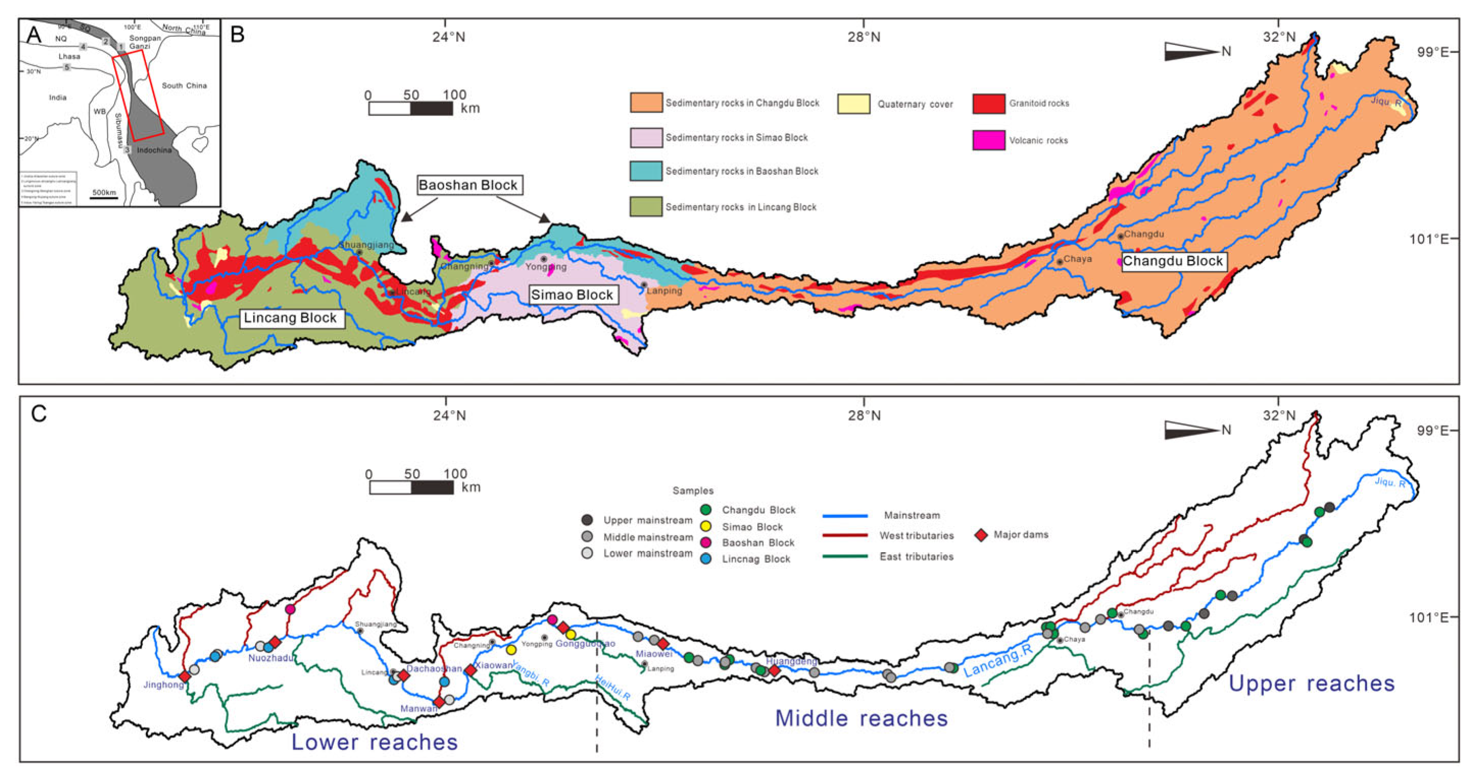
2. The Lancang Basin
2.1. Changdu Block
2.2. Simao Block
2.3. Baoshan Block
2.4. Lincang Block
3. Methods
4. Results
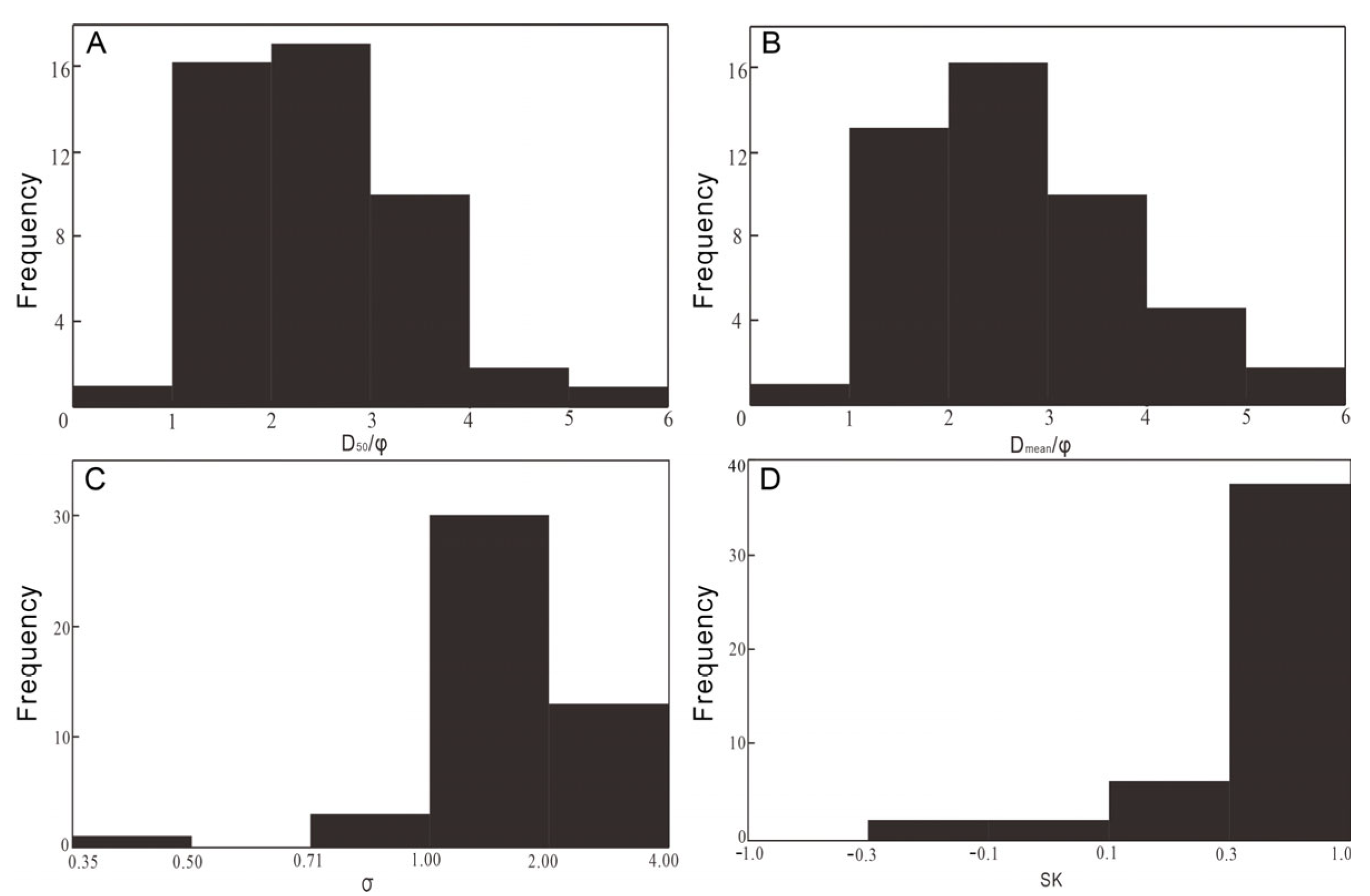
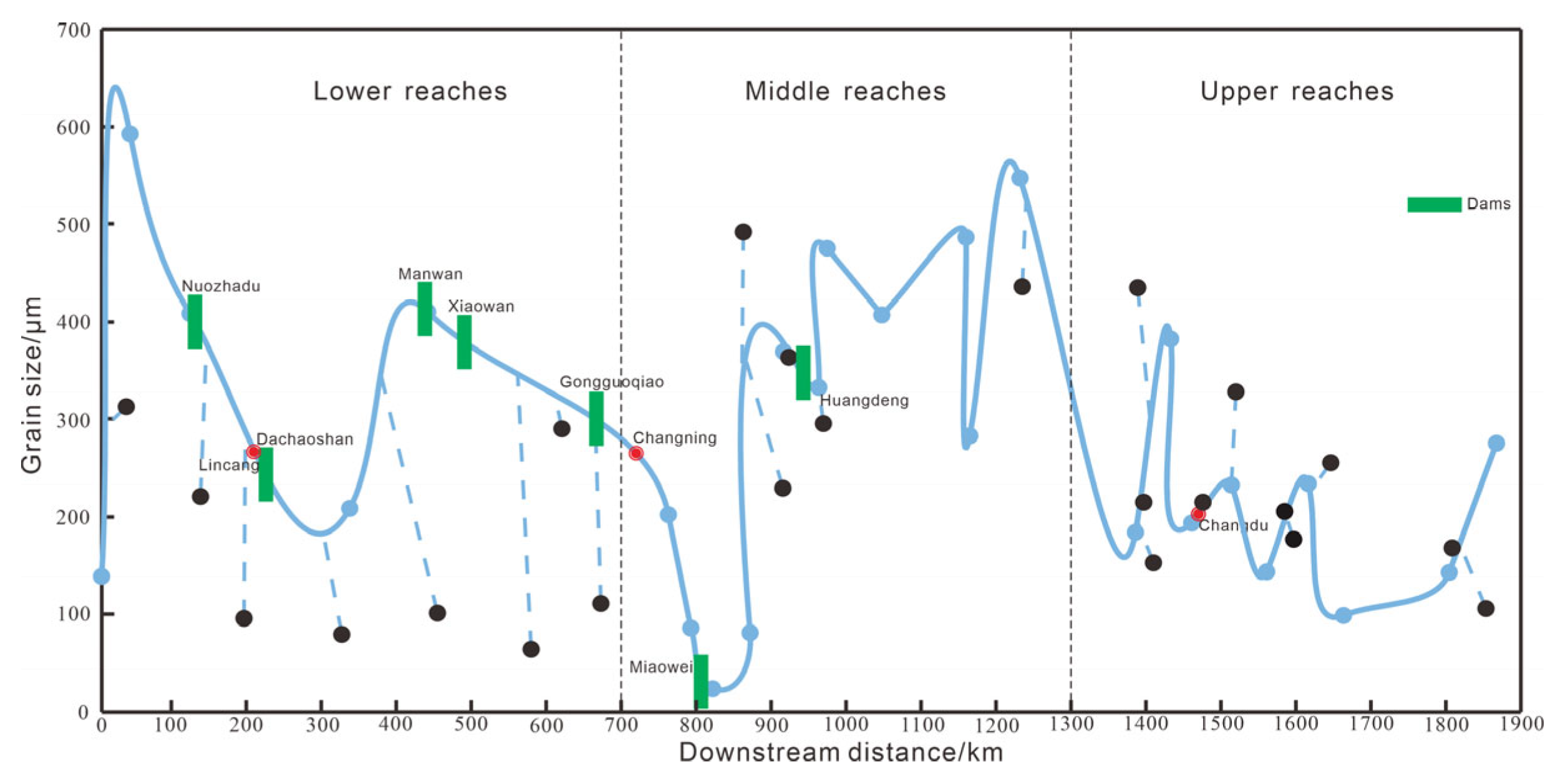
4.1. Texture of Lancang River Sands
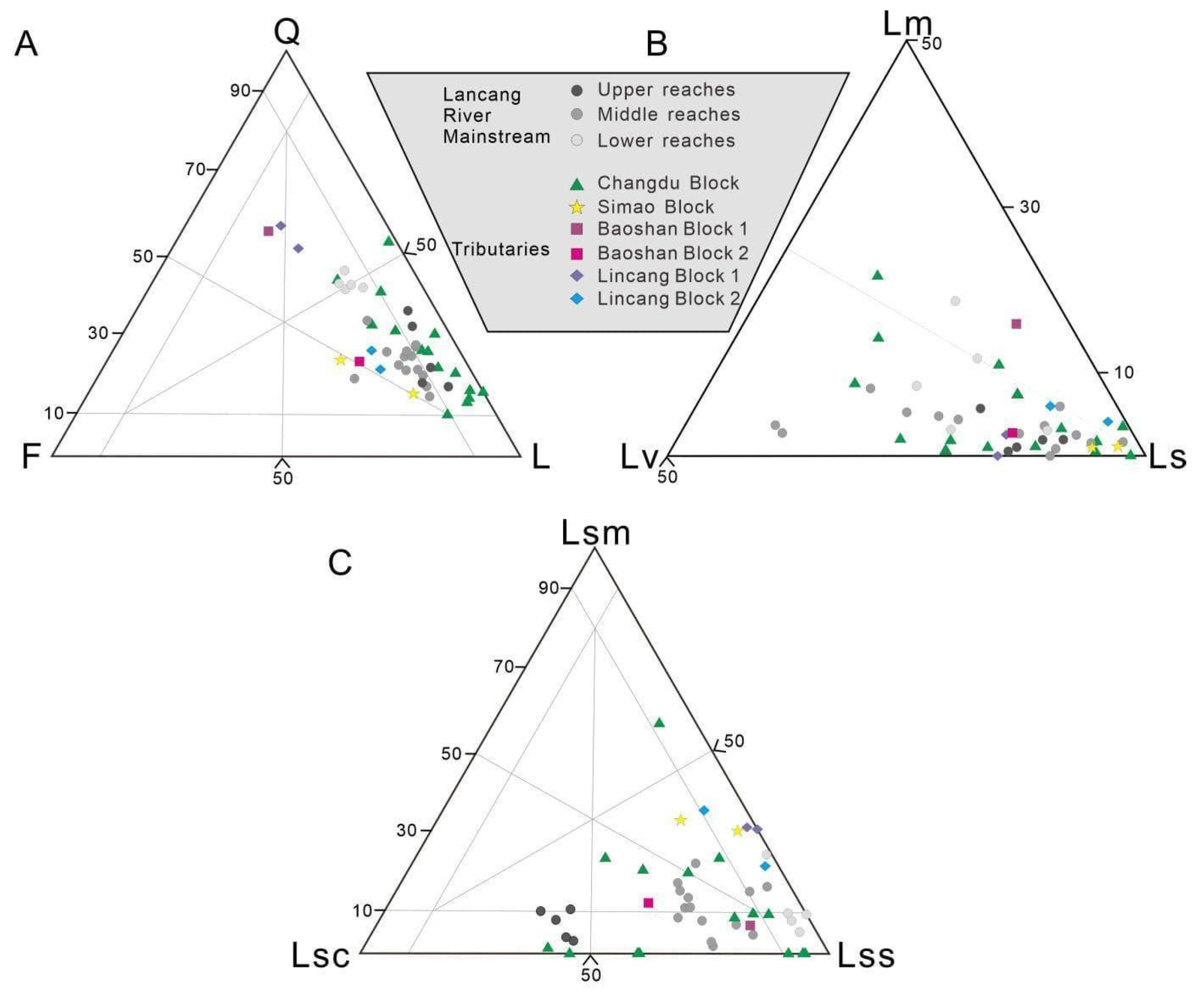
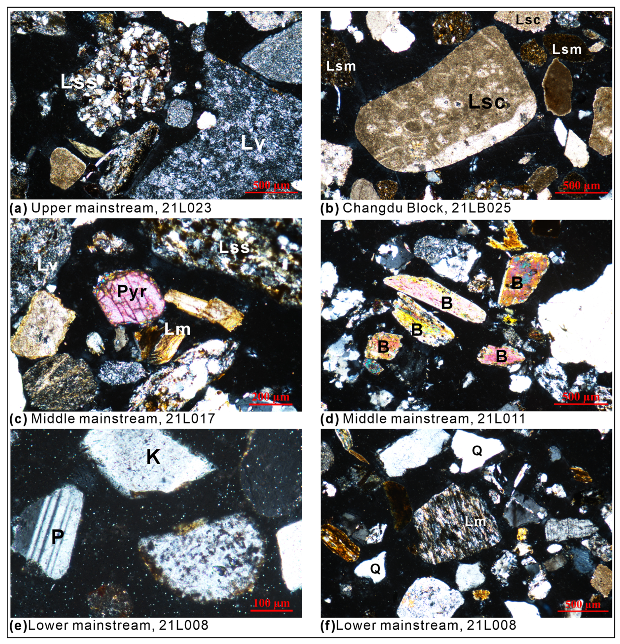
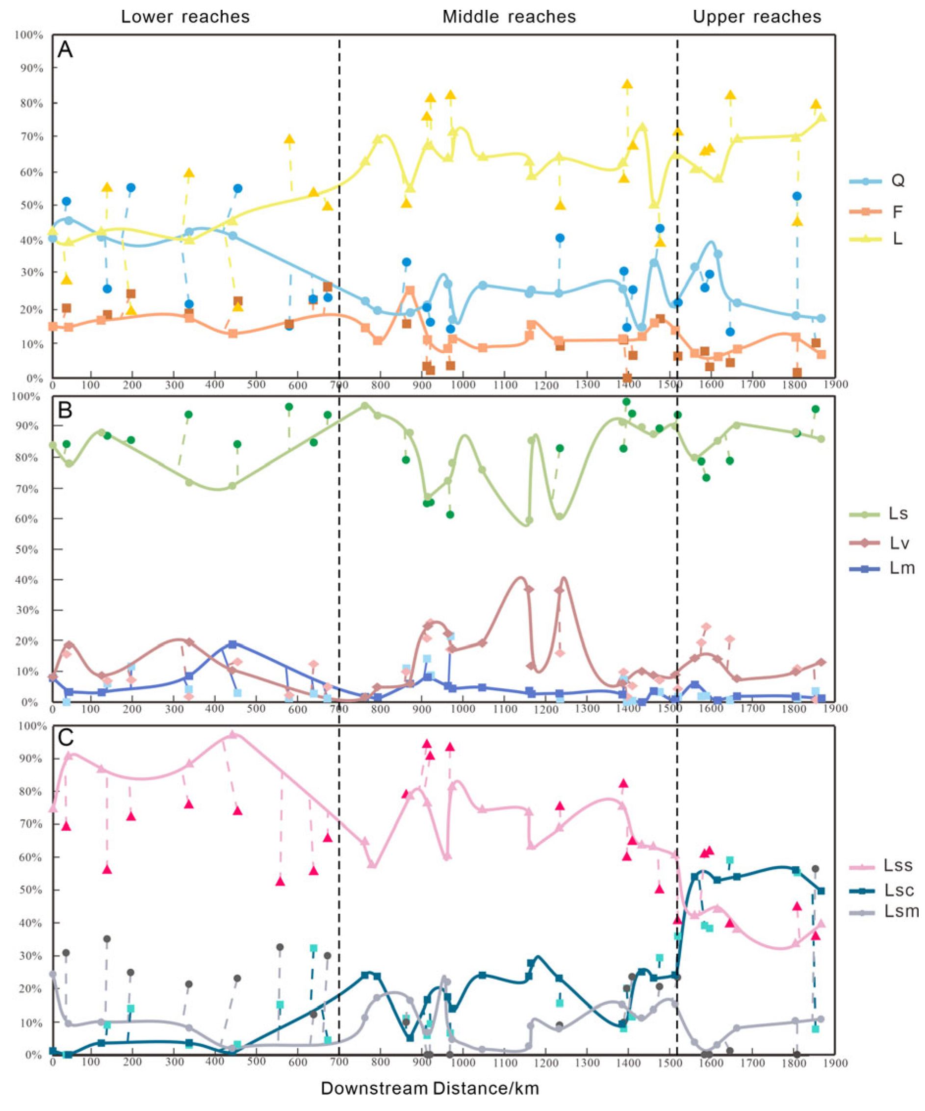
4.2. Petrography of Lancang River Sands
5. Discussion
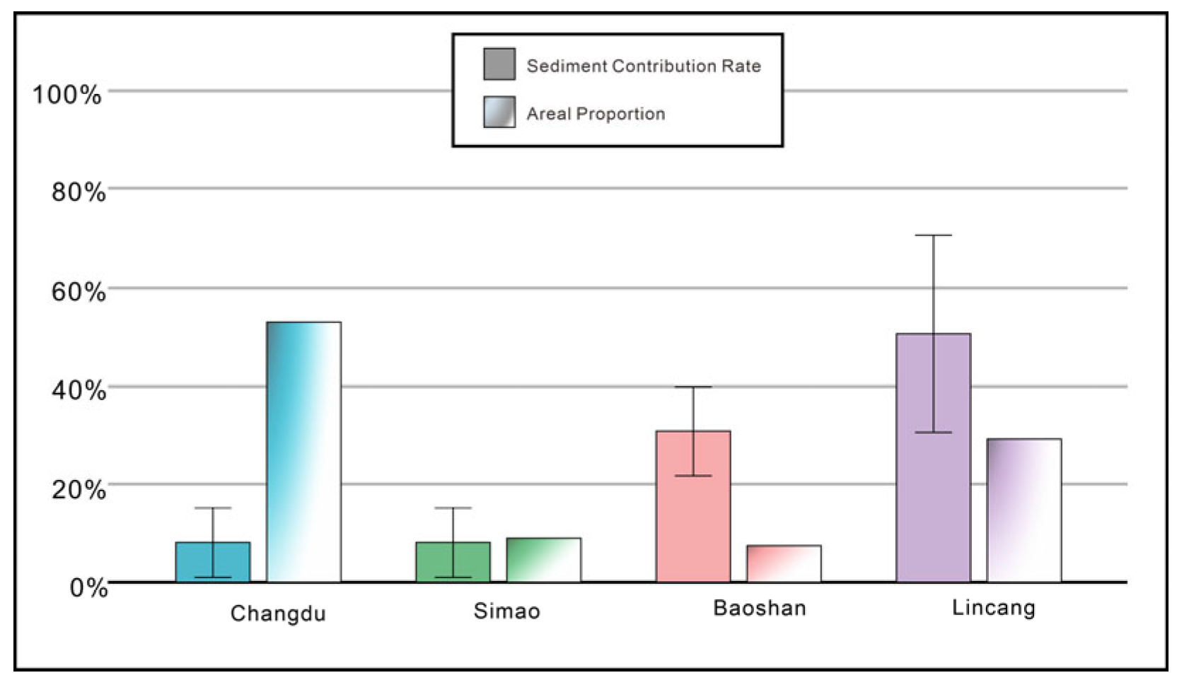
5.1. Provenance Budget Based on Petrographic Data
5.2. First-Cycle Versus Recycled River Sand
5.3. Durability of Carbonate Grains
6. Conclusions
Supplementary Materials
Author Contributions
Funding
Data Availability Statement
Acknowledgments
Conflicts of Interest
Glossary
| Block | Tectono-stratigraphic terranes accreted to an orogenic belt and characterized by a unique assemblage of lithologies, stratigraphic succession, and tectonic evolution. |
| First-cycle sediment | Sediment typically enriched in feldspars, volcanic and/or metamorphic rock fragments, and heavy minerals derived directly from igneous rocks and/or metamorphic basement. |
| Recycled sediment | Sediment typically enriched in durable minerals (quartz, zircon, tourmaline, rutile) derived from the erosion of pre-existing lithified sedimentary rocks or loose siliciclastic deposits. |
References
- Burbank, D.W.; Blythe, A.E.; Putkonen, J.; Pratt-Sitaula, B.; Gabet, E.; Oskin, M.; Barros, A.; Ojha, T.P. Decoupling of erosion and precipitation in the Himalayas. Nature 2003, 426, 652–655. [Google Scholar] [CrossRef] [PubMed]
- Godard, V.; Bourlès, D.L.; Spinabella, F.; Burbank, D.W.; Bookhagen, B.; Fisher, G.B.; Moulin, A.; Léanni, L. Dominance of tectonics over climate in Himalayan denudation. Geology 2014, 42, 243–246. [Google Scholar] [CrossRef]
- Wang, P.; Scherler, D.; Liu-Zeng, J.; Mey, J.; Avouac, J.-P.; Zhang, Y.; Shi, D. Tectonic control of Yarlung Tsangpo Gorge revealed by a buried canyon in Southern Tibet. Science 2014, 346, 978–981. [Google Scholar] [CrossRef] [PubMed]
- Sickmann, Z.T.; Chheda, T.D.; Capaldi, T.N.; Thomson, K.D.; Paull, C.K.; Graham, S.A. Using provenance analysis in an Anthropocene natural laboratory. Quat. Sci. Rev. 2019, 221, 105890. [Google Scholar] [CrossRef]
- Liang, W.; Hu, X. Research progress of sand composition in river sediments. Acta Geol. Sin. 2023, 97, 2975–2991. [Google Scholar] [CrossRef]
- Harris, N. The elevation history of the Tibetan Plateau and its implications for the Asian monsoon. Palaeogeogr. Palaeoclimatol. Palaeoecol. 2006, 241, 4–15. [Google Scholar] [CrossRef]
- Kapp, P.; Murphy, M.A.; Yin, A.; Harrison, T.M.; Ding, L.; Guo, J. Mesozoic and Cenozoic tectonic evolution of the Shiquanhe area of western Tibet. Tectonics 2003, 22, 1029. [Google Scholar] [CrossRef]
- Walling, D.E. Chapter 6—The Sediment Load of the Mekong River. In The Mekong; Campbell, I.C., Ed.; Academic Press: Cambridge, MA, USA, 2009; pp. 113–142. [Google Scholar] [CrossRef]
- Zhang, J.; Yang, H.; Liu-Zeng, J.; Ge, Y.; Wang, W.; Yao, W.; Xu, S. Reconstructing the incision of the Lancang River (Upper Mekong) in southeastern Tibet below its prominent knickzone using fluvial terraces and transient tributary profiles. Geomorphology 2021, 376, 107551. [Google Scholar] [CrossRef]
- Liu, Z.; Colin, C.; Trentesaux, A.; Siani, G.; Frank, N.; Blamart, D.; Farid, S. Late Quaternary climatic control on erosion and weathering in the eastern Tibetan Plateau and the Mekong Basin. Quat. Res. 2005, 63, 316–328. [Google Scholar] [CrossRef]
- Zhang, P.; Najman, Y.; Mei, L.; Millar, I.; Sobel, E.R.; Carter, A.; Barfod, D.; Dhuime, B.; Garzanti, E.; Govin, G.; et al. Palaeodrainage evolution of the large rivers of East Asia, and Himalayan-Tibet tectonics. Earth-Sci. Rev. 2019, 192, 601–630. [Google Scholar] [CrossRef]
- Chen, X.; Chen, Y.; Bao, C.; Li, G.; Yan, J.; Li, D. U-Pb dating and Hf isotopic composition of detrital zircons in the sediments from the Lancang River and its geological significance. Geoscience 2014, 28, 1170–1182. [Google Scholar]
- Huyan, Y.; Zhang, B.; Wang, X.; Lu, Y.; Liu, F. Geochemistry of the Lancang River (Upper Mekong River) overbank sediments: Implications for provenance, weathering and sedimentary characteristics. Appl. Geochem. 2023, 156, 105747. [Google Scholar] [CrossRef]
- Chen, Q.; Kong, X. Lancang-Mekong River Basin Basic Data Collections; Yunnan Science and Technical Press: Kunming, China, 2000; pp. 1–259. [Google Scholar]
- Li, L.; Li, H.; Wang, J. Analysis on hydrological and water quality character and their spatial and temporal distribution in Lancang River. Sci. Geogr. Sin. 2002, 22, 49–56. [Google Scholar]
- Zhang, P.Z.; Shen, Z.; Wang, M.; Gan, W.; Bürgmann, R.; Molnar, P.; Wang, Q.; Niu, Z.; Sun, J.; Wu, J.; et al. Continuous deformation of the Tibetan Plateau from global positioning system data. Geology 2004, 32, 809–812. [Google Scholar] [CrossRef]
- Deng, J.; Wang, Q.; Li, G.; Santosh, M. Cenozoic tectono-magmatic and metallogenic processes in the Sanjiang region, southwestern China. Earth-Sci. Rev. 2014, 138, 268–299. [Google Scholar] [CrossRef]
- Liu, Z.; Colin, C.; Huang, W.; Le, K.P.; Tong, S.; Chen, Z.; Trentesaux, A. Climatic and tectonic controls on weathering in south China and Indochina Peninsula: Clay mineralogical and geochemical investigations from the Pearl, Red, and Mekong drainage basins. Geochem. Geophys. Geosyst. 2007, 8, Q05005. [Google Scholar] [CrossRef]
- Xia, D. Lithostratigraphy of Xizang Autonomous Region; China University of Geosciences Press: Wuhan, China, 1997; pp. 1–302. [Google Scholar]
- Wang, L. Geological Map and Instruction Manual of the Qinghai Tibet Plateau and Its Adjacent Areas; Geology Press: Beijing, China, 2013; pp. 1–155. [Google Scholar]
- Zhong, D. The Paleo-Tethys Orogenic Belt in Western Sichuan and Yunnan Province; Science Press: Beijing, China, 1998; pp. 1–242. [Google Scholar]
- Metcalfe, I. Gondwana dispersion and Asian accretion: Tectonic and palaeogeographic evolution of eastern Tethys. J. Asian Earth Sci. 2013, 66, 1–33. [Google Scholar] [CrossRef]
- Metcalfe, I. Multiple Tethyan ocean basins and orogenic belts in Asia. Gondwana Res. 2021, 100, 87–130. [Google Scholar] [CrossRef]
- Lin, Y.; Wei, G.; Zengtao, C.; Yulong, Y.; Yan, T. LA-ICP-MS Zircon U-Pb Geochronology and Petrology of the Muchang Alkali Granite, Zhenkang County, Western Yunnan Province, China. Acta Geol. Sin. Engl. Ed. 2010, 84, 1488–1499. [Google Scholar] [CrossRef]
- Dong, M.; Dong, G.; Mo, X.; Santosh, M.; Zhu, D.; Yu, J.; Nie, F.; Hu, Z. Geochemistry, zircon U–Pb geochronology and Hf isotopes of granites in the Baoshan Block, Western Yunnan: Implications for Early Paleozoic evolution along the Gondwana margin. Lithos 2013, 179, 36–47. [Google Scholar] [CrossRef]
- Li, D.; Chen, Y.; Hou, K.; Luo, Z. Origin and evolution of the Tengchong block, southeastern margin of the Tibetan Plateau: Zircon U–Pb and Lu–Hf isotopic evidence from the (meta-) sedimentary rocks and intrusions. Tectonophysics 2016, 687, 245–256. [Google Scholar] [CrossRef]
- Zhu, R.; Lai, S.; Qin, J.; Zhao, S.; Santosh, M. Strongly peraluminous fractionated S-type granites in the Baoshan Block, SW China: Implications for two-stage melting of fertile continental materials following the closure of Bangong-Nujiang Tethys. Lithos 2018, 316–317, 178–198. [Google Scholar] [CrossRef]
- Huan, Y.; Li, X.; Lei, H. Zircon U-Pb age and geochemical characteristics of the early palaeozoic granite in Shiganhe-Pinghe area, west Yunnan. Miner. Resour. Geol. 2017, 31, 150–157. [Google Scholar]
- Tao, Y.; Zhu, F.; Ma, Y.; Ye, L.; Cheng, Z. La-ICP-MS analysis of granite in Benzhishan aera, Baoshan Block. Acta Mineral. Sin. 2009, 29, 329. [Google Scholar]
- Liu, B.; Peng, T.; Fan, W.; Zhao, G.; Gao, J.; Dong, X.; Peng, B. Tectonic Evolution and Paleoposition of the Baoshan and Lincang Blocks of West Yunnan During the Paleozoic. Tectonics 2020, 39, e2019TC006028. [Google Scholar] [CrossRef]
- Liu, G. Petrology Component and Geochronology of Early Paleozoic Proto-Tethys Ophiolite Mélange in SW Yunnan. Ph.D. Thesis, China University of Geosciences, Wuhan, China, 2020; pp. 1–153. [Google Scholar]
- Zhao, T.Y. Early Paleozoic Proto-Tethys Tectonics Evolution in SW Yunnan: Constraints from Detrital Zircon U-Pb Geochronology and Granite Associations. Ph.D. Thesis, China University of Geosciences, Wuhan, China, 2019; pp. 1–133. [Google Scholar]
- Nie, X.; Feng, Q.; Qian, X.; Wang, Y. Magmatic Record of Prototethyan Evolution in SW Yunnan, China: Geochemical, Zircon U–Pb Geochronological and Lu–Hf Isotopic Evidence from the Huimin Metavolcanic Rocks in the Southern Lancangjiang Zone. Gondwana Res. 2015, 28, 757–768. [Google Scholar] [CrossRef]
- Xing, X.; Wang, Y.; Cawood, P.A.; Zhang, Y. Early Paleozoic accretionary orogenesis along northern margin of Gondwana constrained by high-Mg metaigneous rocks, SW Yunnan. Int. J. Earth Sci. 2017, 106, 1469–1486. [Google Scholar] [CrossRef]
- Zhao, T.; Feng, Q.; Metcalfe, I.; Milan, L.A.; Liu, G.; Zhang, Z. Detrital zircon U-Pb-Hf isotopes and provenance of Late Neoproterozoic and Early Paleozoic sediments of the Simao and Baoshan blocks, SW China: Implications for Proto-Tethys and Paleo-Tethys evolution and Gondwana reconstruction. Gondwana Res. 2017, 51, 193–208. [Google Scholar] [CrossRef]
- Dong, G.; Mo, X.; Zhao, Z.; Zhu, D.; Goodman, R.C.; Kong, H.; Wang, S. Zircon U–Pb dating and the petrological and geochemical constraints on Lincang granite in Western Yunnan, China: Implications for the closure of the Paleo-Tethys Ocean. J. Asian Earth Sci. 2013, 62, 282–294. [Google Scholar] [CrossRef]
- Luo, B. Petrology Geochemistry, Chronology Characteristics and Their Significances of Early Paleozoic Granite in Yunxian, West Yunnan. Master’s Thesis, Chengdu University of Technology, Chengdu, China, 2020; pp. 1–60. [Google Scholar]
- Peng, Z.; Zhang, J.; Guan, J.; Zhang, Z.; Han, W.; Fu, Y. The discovery of early-midde ordovician granitic gneiss from the giant Lincang batholith in Sangjiang area of western Yunnan and its geological implications. Earth Sci. 2018, 43, 2571–2585. [Google Scholar]
- Ingersoll, R.V.; Bullard, T.F.; Ford, R.L.; Grimm, J.P.; Pickle, J.D.; Sares, S.W. The effect of grain size on detrital modes: A test of the Gazzi-Dickinson point-counting method. J. Sediment. Res. 1984, 54, 103–116. [Google Scholar] [CrossRef]
- Folk, R.L.; Ward, W.C. Brazos River bar [Texas]; A study in the significance of grain size parameters. J. Sediment. Res. 1957, 27, 3–26. [Google Scholar] [CrossRef]
- Garzanti, E. From static to dynamic provenance analysis—Sedimentary petrology upgraded. Sediment. Geol. 2016, 336, 3–13. [Google Scholar] [CrossRef]
- Garzanti, E. Petrographic classification of sand and sandstone. Earth-Sci. Rev. 2019, 192, 545–563. [Google Scholar] [CrossRef]
- Weltje, G.J. End-member modeling of compositional data: Numerical-statistical algorithms for solving the explicit mixing problem. Math. Geol. 1997, 29, 503–549. [Google Scholar] [CrossRef]
- Resentini, A.; Goren, L.; Castelltort, S.; Garzanti, E. Partitioning sediment flux by provenance and tracing erosion patterns in Taiwan. J. Geophys. Res. Earth Surf. 2017, 122, 1430–1454. [Google Scholar] [CrossRef]
- Liang, W.; Garzanti, E.; Hu, X.; Resentini, A.; Vezzoli, G.; Yao, W. Tracing erosion patterns in South Tibet: Balancing sediment supply to the Yarlung Tsangpo from the Himalaya versus Lhasa Block. Basin Res. 2022, 34, 411–439. [Google Scholar] [CrossRef]
- Fu, K.; Yang, W.; Su, B.; Li, D.; Li, M.; Zhang, J.; Song, J. Response of river sediments to basin environmental changes: A case study of the Lancang River. Prog. Geogr. 2015, 34, 1148–1155. [Google Scholar]
- Mo, B. Application of Particle Size Analysis in Sedimentary Characteristics: A case study of quaternart sediments from Zhujiang delta. Nei Jiang Ke Ji 2018, 39, 24–25. [Google Scholar]
- Syvitski, J.P.M.; Vörösmarty, C.J.; Kettner, A.J.; Green, P. Impact of Humans on the Flux of Terrestrial Sediment to the Global Coastal Ocean. Science 2005, 308, 376–380. [Google Scholar] [CrossRef]
- Dai, S.; Yang, S.; Li, M. The sharp decrease in suspended sediment supply from China’s rivers to the sea: Anthropogenic and natural causes. Hydrol. Sci. J. 2009, 54, 135–146. [Google Scholar] [CrossRef]
- Wang, H.; Sun, F. Variability of annual sediment load and runoff in the Yellow River for the last 100 years (1919–2018). Sci. Total Environ. 2021, 758, 143715. [Google Scholar] [CrossRef] [PubMed]
- Grant, G.E. The Geomorphic Response of Gravel-Bed Rivers to Dams: Perspectives and Prospects. In Gravel-Bed Rivers; John Wiley & Sons, Inc.: Hoboken, NJ, USA, 2012; pp. 165–181. [Google Scholar] [CrossRef]
- Topping, D.J.; Rubin, D.M.; Melis, T.S. Coupled changes in sand grain size and sand transport driven by changes in the upstream supply of sand in the Colorado River: Relative importance of changes in bed-sand grain size and bed-sand area. Sediment. Geol. 2007, 202, 538–561. [Google Scholar] [CrossRef]
- Guo, X.; Zhu, X.; Yang, Z.; Ma, J.; Xiao, S.; Ji, D.; Liu, D. Impacts of cascade reservoirs on the longitudinal variability of fine sediment characteristics: A case study of the Lancang and Nu Rivers. J. Hydrol. 2020, 581, 124343. [Google Scholar] [CrossRef]
- Pszonka, J.; Wendorff, M. Cathodoluminescence-revealed diagenesis of carbonates and feldspars in Cergowa sandstones (Oligocene), Outer Carpathians. Gospod. Surowcami Miner. 2014, 30, 21–36. [Google Scholar]
- Pszonka, J.; Wendorff, M. Carbonate cements and grains in submarine fan sandstones—The Cergowa Beds (Oligocene, Carpathians of Poland) recorded by cathodoluminescence. Int. J. Earth Sci. 2017, 106, 269–282. [Google Scholar] [CrossRef]
- Singh, S.K.; France-Lanord, C. Tracing the distribution of erosion in the Brahmaputra watershed from isotopic compositions of stream sediments. Earth Planet. Sci. Lett. 2002, 202, 645–662. [Google Scholar]
- Garzanti, E.; Vermeesch, P.; Vezzoli, G.; And‘o, S.; Botti, E.; Limonta, M.; Dinis, P.; Hahn, A.; Baudet, D.; De Grave, J.; et al. Congo River sand and the equatorial quartz factory. Earth-Sci. Rev. 2019, 197, 102918. [Google Scholar] [CrossRef]
- Garzanti, E.; He, J.; Barbarano, M.; Resentini, A.; Li, C.; Yang, L.; Yang, S.; Wang, H. Provenance versus weathering control on sediment composition in tropical monsoonal climate (South China)-2. Sand petrology and heavy minerals. Chem. Geol. 2021, 564, 119997. [Google Scholar]
- Garzanti, E. The maturity myth in sedimentology and provenance analysis. J. Sediment. Res. 2017, 87, 353–365. [Google Scholar] [CrossRef]
- Xu, Y.; Jin, Z.; Gou, L.F.; Galy, A.; Jin, C.; Chen, C.; Li, C.; Deng, L. Carbonate weathering dominates magnesium isotopes in large rivers: Clues from the Yangtze River. Chem. Geol. 2022, 588, 120677. [Google Scholar] [CrossRef]
- Li, C.; Wang, S.; Bai, X.; Tan, Q.; Li, H.; Li, Q.; Deng, Y.; Yang, Y.; Tian, S.; Hu, Y. Estimation of carbonate rock weathering-related carbon sink in global major river basins. Acta Geogr. Sin. 2019, 74, 1319–1332. [Google Scholar]

| Sample ID | Downstream Distance/km | Latitude (N) | Longitude (E) | Location | River | D10/φ | D50/φ | D90/φ | Dmean/φ | σ | SK |
|---|---|---|---|---|---|---|---|---|---|---|---|
| 21L006 | 0 | 21.85053 | 101.01257 | Manjucun, Jinghong | Lower Lancang River | 1.736 | 3.028 | 7.117 | 3.647 | 2.053 | 0.513 |
| 21L007 | 38.8 | 22.01052 | 100.80678 | Xishuangbanna Bridge | Lower Lancang River | 0.069 | 0.803 | 1.773 | 0.831 | 1.042 | 0.342 |
| 21L008 | 125.9 | 22.50944 | 100.57599 | Simaogang, Puer | Lower Lancang River | 0.413 | 1.413 | 3.203 | 1.487 | 1.307 | 0.345 |
| 21L009 | 338.3 | 23.91246 | 100.41335 | Jiezizhaicun, Yuanxian | Lower Lancang River | 1.528 | 2.368 | 3.308 | 2.385 | 0.714 | 0.089 |
| 21L011 | 442.5 | 24.60885 | 100.46058 | Manwan, Yunxian | Lower Lancang River | 0.299 | 1.453 | 5.297 | 1.911 | 1.788 | 0.493 |
| 21L013 | 763.7 | 26.25866 | 99.1335 | Dabizancun, Lanping | Middle Lancang River | 1.213 | 2.506 | 7.204 | 3.252 | 2.213 | 0.549 |
| 21L014 | 793.5 | 26.47022 | 99.14607 | Yingpanqiao, Laning | Middle Lancang River | 2.061 | 4.791 | 8.777 | 5.100 | 2.615 | 0.190 |
| 21L016 | 872 | 27.07261 | 99.17453 | Weideng, Diqing | Middle Lancang River | 2.574 | 3.779 | 7.473 | 4.222 | 1.810 | 0.480 |
| 21L017 | 914.6 | 27.36663 | 99.0851 | Baijixun, Diqing | Middle Lancang River | 0.505 | 1.576 | 5.052 | 1.698 | 1.583 | 0.400 |
| 21L018 | 963.7 | 27.71149 | 99.04798 | Yezhi, Diqing | Middle Lancang River | 0.805 | 1.643 | 4.407 | 1.703 | 1.362 | 0.401 |
| 21L019 | 974.9 | 27.79151 | 99.03116 | Bujiecun, Diqing | Middle Lancang River | 0.295 | 1.118 | 4.042 | 1.182 | 1.428 | 0.417 |
| 21L020 | 1047.7 | 28.30534 | 98.87471 | Deqin | Middle Lancang River | 0.415 | 1.454 | 2.815 | 1.507 | 1.050 | 0.221 |
| 21L022-1 | 1160.8 | 29.09714 | 98.61262 | Quzika, Mangkang | Middle Lancang River | 0.065 | 1.282 | 2.823 | 1.337 | 1.217 | 0.207 |
| 21L022 | 1165.3 | 29.13235 | 98.63051 | Lajiuxicun, Mangkang | Middle Lancang River | 0.978 | 1.927 | 3.383 | 1.992 | 1.344 | 0.364 |
| 21L023 | 1232.9 | 29.62561 | 98.35249 | Rumei, Mangkang | Middle Lancang River | −0.085 | 1.047 | 2.881 | 1.131 | 1.576 | 0.361 |
| 21L025 | 1386.4 | 30.60655 | 97.52622 | Kagongcun, Chaya | Upper Lancang River | 1.534 | 2.566 | 5.804 | 2.669 | 1.480 | 0.385 |
| 21L026 | 1433.9 | 30.9402 | 97.36719 | Tigongcun, Changdu | Upper Lancang River | 0.589 | 1.461 | 2.808 | 1.516 | 1.429 | 0.397 |
| 21L027 | 1461.1 | 31.08413 | 97.203 | Botuocun, Changdu | Upper Lancang River | 1.668 | 2.427 | 3.378 | 2.456 | 0.936 | 0.304 |
| 21L028 | 1514.4 | 31.46377 | 97.19023 | Gaoatongcun, Changdu | Upper Lancang River | 1.205 | 2.137 | 7.105 | 2.813 | 2.012 | 0.636 |
| 23L29 | 1561.1 | 31.78711 | 97.00243 | Jiarongcun, Changdu | Upper Lancang River | 1.758 | 3.057 | 5.394 | 3.223 | 1.557 | 0.333 |
| 23L30 | 1616.8 | 32.06843 | 96.76559 | Bariniangcun, Nangqian | Upper Lancang River | 1.541 | 2.133 | 2.789 | 2.143 | 0.490 | 0.062 |
| 23L31 | 1663.5 | 32.27281 | 96.46386 | Zhangjicecun, Nangqian | Upper Lancang River | 2.330 | 3.517 | 6.943 | 3.798 | 1.694 | 0.434 |
| 23L33 | 1805.2 | 32.84496 | 95.552 | Duonacun, Nangqian | Upper Lancang River | 2.059 | 2.856 | 4.145 | 2.909 | 1.175 | 0.374 |
| 23L34 | 1867.5 | 32.94123 | 95.138 | Suijia, Zaduo | Upper Lancang River | 0.828 | 2.051 | 4.998 | 2.316 | 1.751 | 0.430 |
| 21LB015 | 33.4 | 21.99248 | 100.83041 | Mingjiangyuan | Liusha River | 0.627 | 1.880 | 5.298 | 2.315 | 1.781 | 0.452 |
| 21LB013 | 139.1 | 22.57872 | 100.53739 | Nuozhadu, Puer | Zhong River | 1.081 | 2.254 | 7.800 | 3.422 | 2.593 | 0.651 |
| 21LB012 | 337.9 | 23.91212 | 100.42524 | Xiushancun, Puer | Gali River | 2.508 | 3.960 | 7.835 | 4.463 | 2.018 | 0.441 |
| 21LB011 | 455 | 24.49335 | 100.30111 | Yunxian, Lincang | Luozha River | 2.276 | 3.600 | 6.248 | 3.852 | 1.546 | 0.328 |
| 21LB014 | 197.8 | 22.64531 | 100.11734 | Lancang, Puer | Hei River | 2.360 | 3.706 | 6.452 | 3.992 | 1.585 | 0.336 |
| 21LB006 | 639.8 | 25.44094 | 99.28604 | Wayao, Yunlong | Wayao River | 0.675 | 2.203 | 4.155 | 2.233 | 1.555 | 0.209 |
| 21LB009 | 580.1 | 25.08667 | 99.75802 | Yongping, Dali | Yongping River | 2.804 | 4.315 | 8.367 | 4.902 | 2.139 | 0.452 |
| 21LB007 | 673 | 25.62547 | 99.35982 | Yunlong | Pijiang River | 2.224 | 3.240 | 7.321 | 3.750 | 1.806 | 0.558 |
| 21LB005 | 863.6 | 26.98093 | 99.21461 | Biyuhexiacun, Lanping | Tongdian River | −0.059 | 1.212 | 4.476 | 1.609 | 1.953 | 0.477 |
| 21LB004 | 913.3 | 27.35236 | 99.0996 | Baiji, Weixi | Yongchun River | 1.171 | 2.240 | 5.380 | 2.542 | 1.588 | 0.460 |
| 21LB003 | 921.8 | 27.40308 | 99.04969 | Baijixun, Weixi | Laochang River | 0.362 | 1.688 | 6.861 | 2.683 | 2.448 | 0.580 |
| 21LB002 | 969.6 | 27.75023 | 99.04312 | Xiacun, Weixi | Lancang River | 0.680 | 2.045 | 5.648 | 2.230 | 1.758 | 0.365 |
| 21LB022 | 1389.1 | 30.6198 | 97.51119 | Kagongxiang, Chaya | Sequ River | 0.089 | 1.549 | 3.658 | 1.655 | 1.667 | 0.287 |
| 21LB023 | 1397.7 | 30.63645 | 97.49381 | Kagongxiang | Xiqu River | 0.474 | 5.835 | 9.317 | 5.090 | 3.463 | −0.214 |
| 21LB026 | 1476.7 | 31.16993 | 97.10522 | Shagongcun, Changdu | Anngqu River | 1.509 | 2.289 | 3.231 | 2.313 | 0.935 | 0.287 |
| 21LB021 | 1235 | 29.6437 | 98.35329 | Duibacun, Mangkang | Rongqu River | 0.295 | 1.339 | 3.113 | 1.430 | 1.472 | 0.374 |
| 21LB024 | 1410.1 | 30.65892 | 97.57458 | Yanduosi, Chaya | Maiqu River | 1.407 | 3.119 | 8.597 | 4.172 | 2.798 | 0.527 |
| 21LB025 | 1520.1 | 31.50431 | 97.21045 | Sexiongkacun, Chaya | Requ River | 0.642 | 1.627 | 7.883 | 3.016 | 2.749 | 0.723 |
| 23LB31 | 1585.5 | 31.96893 | 96.94544 | Gaiqu Bridge, Changdu | Ziqu River | 1.499 | 2.342 | 4.986 | 2.405 | 1.345 | 0.397 |
| 23LB30 | 1597.3 | 32.0532 | 97.00347 | Batongcun, Changdu | Ziqu River | 1.581 | 2.599 | 6.912 | 2.780 | 1.612 | 0.448 |
| 23LB27 | 1646.4 | 32.14131 | 96.54105 | Jiamashenshan, Nangqian | Qiangqu River | 0.804 | 2.290 | 6.853 | 2.711 | 2.170 | 0.454 |
| 23LB28 | 1809.1 | 32.8746 | 95.57029 | Duonacun, Zaduo | Shaqunqu River | 1.645 | 2.643 | 6.182 | 3.002 | 1.703 | 0.522 |
| 23LB29 | 1854.5 | 32.89482 | 95.23348 | Zaduo | Jinaiqu River | 1.849 | 3.967 | 8.964 | 4.743 | 2.757 | 0.404 |
| Sample ID | Drainage Area | Q | F | L | Lsm | Lsc | Lss | Cht | Lv | Lm | HM | Total |
|---|---|---|---|---|---|---|---|---|---|---|---|---|
| 21L006 | Lower Mainstem | 158 | 57 | 164 | 30 | 2 | 93 | 0 | 20 | 19 | 21 | 400 |
| 21L007 | Lower Mainstem | 180 | 58 | 155 | 11 | 0 | 105 | 5 | 29 | 5 | 7 | 400 |
| 21L008 | Lower Mainstem | 156 | 64 | 160 | 14 | 5 | 122 | 0 | 14 | 5 | 22 | 402 |
| 21L009 | Lower Mainstem | 163 | 67 | 153 | 9 | 4 | 97 | 0 | 30 | 13 | 17 | 400 |
| 21L011 | Lower Mainstem | 131 | 41 | 144 | 2 | 1 | 99 | 0 | 15 | 27 | 84 | 400 |
| 21L013 | Middle Mainstem | 91 | 59 | 254 | 28 | 59 | 159 | 0 | 4 | 4 | 6 | 410 |
| 21L014 | Middle Mainstem | 76 | 42 | 266 | 43 | 59 | 147 | 0 | 13 | 4 | 22 | 406 |
| 21L016 | Middle Mainstem | 70 | 94 | 201 | 29 | 9 | 139 | 0 | 12 | 12 | 35 | 400 |
| 21L017 | Middle Mainstem | 82 | 43 | 259 | 12 | 29 | 133 | 0 | 64 | 21 | 16 | 400 |
| 21L018 | Middle Mainstem | 106 | 33 | 247 | 38 | 30 | 104 | 7 | 55 | 13 | 14 | 400 |
| 21L019 | Middle Mainstem | 66 | 44 | 276 | 10 | 30 | 174 | 2 | 48 | 12 | 14 | 400 |
| 21L020 | Middle Mainstem | 105 | 34 | 250 | 3 | 45 | 139 | 3 | 48 | 12 | 11 | 400 |
| 21L022-1 | Middle Mainstem | 97 | 49 | 247 | 4 | 35 | 108 | 0 | 91 | 9 | 7 | 400 |
| 21L022 | Middle Mainstem | 100 | 61 | 228 | 17 | 54 | 123 | 1 | 27 | 6 | 11 | 400 |
| 21L023 | Middle Mainstem | 97 | 43 | 252 | 12 | 35 | 104 | 2 | 92 | 7 | 8 | 400 |
| 21L025 | Upper Mainstem | 103 | 45 | 247 | 34 | 21 | 168 | 3 | 15 | 6 | 5 | 400 |
| 21L026 | Upper Mainstem | 59 | 48 | 288 | 29 | 65 | 165 | 0 | 29 | 0 | 5 | 400 |
| 21L027 | Upper Mainstem | 129 | 62 | 194 | 23 | 39 | 106 | 2 | 17 | 7 | 15 | 400 |
| 21L028 | Upper Mainstem | 85 | 55 | 256 | 35 | 55 | 138 | 3 | 23 | 2 | 4 | 400 |
| 23L29 | Upper Mainstem | 122 | 27 | 229 | 7 | 99 | 77 | 0 | 33 | 13 | 23 | 401 |
| 23L30 | Upper Mainstem | 146 | 25 | 234 | 6 | 106 | 88 | 0 | 33 | 1 | 7 | 412 |
| 23L31 | Upper Mainstem | 86 | 33 | 272 | 20 | 133 | 93 | 0 | 21 | 5 | 14 | 405 |
| 23L33 | Upper Mainstem | 72 | 47 | 274 | 25 | 136 | 81 | 0 | 27 | 5 | 8 | 401 |
| 23L34 | Upper Mainstem | 69 | 27 | 300 | 28 | 128 | 102 | 0 | 39 | 3 | 5 | 401 |
| 21LB015 | Lincang Block | 153 | 61 | 83 | 21 | 0 | 47 | 2 | 13 | 0 | 103 | 400 |
| 21LB013 | Lincang Block | 102 | 73 | 217 | 66 | 17 | 105 | 1 | 15 | 13 | 8 | 400 |
| 21LB012 | Lincang Block | 79 | 70 | 219 | 44 | 6 | 156 | 0 | 4 | 9 | 32 | 400 |
| 21LB011 | Lincang Block | 170 | 67 | 63 | 16 | 1 | 35 | 1 | 8 | 2 | 132 | 432 |
| 21LB014 | Baoshan Block | 126 | 58 | 43 | 2 | 4 | 25 | 3 | 3 | 6 | 180 | 407 |
| 21LB006 | Baoshan Block | 79 | 78 | 184 | 19 | 50 | 86 | 1 | 23 | 5 | 59 | 400 |
| 21LB009 | Simao Block | 58 | 59 | 266 | 84 | 39 | 134 | 0 | 6 | 3 | 17 | 400 |
| 21LB007 | Simao Block | 93 | 105 | 197 | 55 | 8 | 120 | 2 | 10 | 2 | 5 | 400 |
| 21LB005 | Changdu Block | 128 | 60 | 192 | 15 | 17 | 120 | 0 | 19 | 21 | 21 | 401 |
| 21LB004 | Changdu Block | 78 | 13 | 289 | 0 | 11 | 177 | 0 | 60 | 41 | 22 | 402 |
| 21LB003 | Changdu Block | 62 | 9 | 309 | 0 | 19 | 183 | 0 | 80 | 27 | 26 | 406 |
| 21LB002 | Changdu Block | 56 | 14 | 320 | 0 | 13 | 183 | 0 | 55 | 69 | 11 | 401 |
| 21LB022 | Changdu Block | 116 | 41 | 216 | 17 | 14 | 143 | 5 | 21 | 16 | 27 | 400 |
| 21LB023 | Changdu Block | 59 | 0 | 341 | 67 | 67 | 201 | 0 | 6 | 0 | 0 | 400 |
| 21LB026 | Changdu Block | 170 | 67 | 153 | 26 | 37 | 63 | 11 | 11 | 5 | 10 | 400 |
| 21LB021 | Changdu Block | 163 | 37 | 200 | 15 | 26 | 125 | 0 | 32 | 2 | 3 | 403 |
| 21LB024 | Changdu Block | 102 | 26 | 267 | 59 | 29 | 162 | 2 | 14 | 1 | 5 | 400 |
| 21LB025 | Changdu Block | 87 | 25 | 283 | 60 | 92 | 104 | 10 | 12 | 5 | 5 | 400 |
| 23LB31 | Changdu Block | 105 | 31 | 263 | 0 | 81 | 126 | 0 | 51 | 5 | 13 | 412 |
| 23LB30 | Changdu Block | 116 | 12 | 256 | 0 | 72 | 116 | 0 | 63 | 5 | 16 | 400 |
| 23LB27 | Changdu Block | 52 | 17 | 317 | 3 | 148 | 99 | 0 | 65 | 2 | 21 | 407 |
| 23LB28 | Changdu Block | 202 | 6 | 173 | 0 | 84 | 68 | 0 | 19 | 2 | 19 | 400 |
| 23LB29 | Changdu Block | 40 | 40 | 310 | 166 | 23 | 105 | 3 | 2 | 11 | 10 | 400 |
Disclaimer/Publisher’s Note: The statements, opinions and data contained in all publications are solely those of the individual author(s) and contributor(s) and not of MDPI and/or the editor(s). MDPI and/or the editor(s) disclaim responsibility for any injury to people or property resulting from any ideas, methods, instructions or products referred to in the content. |
© 2025 by the authors. Licensee MDPI, Basel, Switzerland. This article is an open access article distributed under the terms and conditions of the Creative Commons Attribution (CC BY) license (https://creativecommons.org/licenses/by/4.0/).
Share and Cite
Fang, D.; Hu, X.; Garzanti, E.; Lai, W.; Chen, F. Petrology of Lancang (Upper Mekong) River Sand. Geosciences 2025, 15, 415. https://doi.org/10.3390/geosciences15110415
Fang D, Hu X, Garzanti E, Lai W, Chen F. Petrology of Lancang (Upper Mekong) River Sand. Geosciences. 2025; 15(11):415. https://doi.org/10.3390/geosciences15110415
Chicago/Turabian StyleFang, Daxin, Xiumian Hu, Eduardo Garzanti, Wen Lai, and Fengting Chen. 2025. "Petrology of Lancang (Upper Mekong) River Sand" Geosciences 15, no. 11: 415. https://doi.org/10.3390/geosciences15110415
APA StyleFang, D., Hu, X., Garzanti, E., Lai, W., & Chen, F. (2025). Petrology of Lancang (Upper Mekong) River Sand. Geosciences, 15(11), 415. https://doi.org/10.3390/geosciences15110415


