Abstract
Due to cyclic wetting and drying, the hydro-mechanical behavior of unsaturated soil is impacted significantly. In order to assess the soil strength parameters, knowing the unsaturated behavior is important. Soil moisture content is an important parameter that can define the shear strength of the soil. Most of the highway slopes of Mississippi are built on highly expansive clay. During summer, the evaporation of moisture in the soil leads to shrinkage and the formation of desiccation cracks, while during rainfall, the soil swells due to the infiltration of water. In addition to this, the rainwater gets trapped in these cracks and creates perched conditions, leading to the increased moisture content and reduced shear strength of slope soil. The increased precipitation due to climate change is causing failure conditions on many highway slopes of Mississippi. Vetiver, a perennial grass, can be a transformative solution to reduce the highway slope failure challenges of highly plastic clay. The grass has deep and fibrous roots, which provide additional shear strength to the soil. The root can uptake a significant amount of water from the soil, keeping the moisture balance of the slope. The objective of the current study is to assess the changes in moisture contents of a highway slope in Mississippi after the Vetiver plantation. Monitoring equipment, such as rain gauges and moisture sensors, were installed to monitor the rainfall of the area and the moisture content of the soil. The data showed that the moisture content conditions were improved with the aging of the grass. The light detection and ranging (LiDAR) analysis was performed to validate the field data obtained from different sensors, and it was found that there was no significant slope movement after the Vetiver plantation. The study proves the performance of the Vetiver grass in improving the unsaturated soil behavior and stability of highway slopes built on highly expansive clay.
1. Introduction
The behavior of expansive soil highly relies on the changes in soil moisture contents. There is a buildup and breakdown within soil molecules when they are subjected to repeated wetting and drying due to the continuous increase in unstable aggregates [1]. The continuous changes in moisture contents lead to volume changes in clay soils. When the soil sample becomes wet, it expands, leading to an increase in volume. Upon drying, the sample reduces its volume, undergoing shrinkage. Clay soils found under natural conditions are subjected to cyclic swelling and shrinkage due to seasonal moisture change. The cyclic wetting and drying of clay soil results in a decreased clay content and reduced plasticity. Khan et al. 2019 found that the number of wet–dry cycles has been shown to increase the void ratio of highly expansive Yazoo clay, leading to a notable decrease in its shear strength, particularly cohesion. After seven wet–dry cycles, cohesion decreased by 77%. This decrease in shear strength affects the stability of the slopes made of Yazoo clay, with the shear strength of the topsoil decreasing from 2.7 to 1.4 with increasing wet–dry cycles. Moreover, when considering the impact of rainfall, specifically in two periods with varying intensities, the factor of safety decreased significantly. For instance, with rainfall of 126.2 mm (2 h) and 271.7 mm over three days, the factor of safety decreased from 1.7 to 1.2 and from 1.68 to 1.02, respectively, when factoring in three, five, and seven wet–dry cycles in the topsoil. This reduction in safety factor is attributed to the combined effects of decreased shear strength due to wet–dry cycles and saturation caused by prolonged rainfall [2]. This reduction is primarily due to particle aggregation during drying, leading to a decrease in the surface area available for interaction with water, including a decrease in the liquid limit. Therefore, particle aggregation reduces the surface area for interaction with water, ultimately lowering clay content and plasticity. After each repeated wetting and drying cycle, the soil exhibits signs of fatigue [3].
In arid or semi-arid areas, expansive soils are subjected to periodic wetting and drying, and as a result, ground movement is a common occurrence in those regions [4]. The majority of the highway slopes in the southern region of the United States, including Mississippi, Texas, Louisiana, and Alabama, are built on highly expansive clay soil. Slopes in this region are vulnerable to failure due to the high plasticity and abrupt volume change in slope soil [5]. During summer, desiccation cracks are formed due to reduced moisture content and shrinkage. In the rainy season, rainwater permeates the soil layer through these cracks. Through repeated wetting and drying cycles, the infiltrated rainwater establishes a perched condition within the slope, elevating the moisture content and reducing the soil’s matric suction [6,7]. The clay mineralogy of the soil influences the physical and engineering characteristics of fine-grained soil, including factors such as liquid limit, compressibility, and shear strength [8]. Typically, clay soils are characterized by three primary minerals: illite (mica), kaolinite (Kaolin), and montmorillonite (smectite), alongside other mineral varieties. The extent of swelling potential differs among soils, contingent upon their mineralogical compositions. Specifically, soils rich in montmorillonite minerals may undergo swelling, facilitated by the formation of a diffuse double layer and flocculation. Montmorillonite possesses a notably greater surface area, drawing in a substantial amount of water, and is classified as a high-plasticity clay. The double layer of water surrounding montmorillonite is thickest among clays [9]. The Yazoo clay found in Mississippi comprises 28% smectite, with montmorillonite being a specific type of smectite. This high smectite content is responsible for the rapid shrink–swell characteristics observed in this soil type. In numerous areas, such as those near the metropolitan Jackson region, the highway slopes are built at a steeper gradient (approximately 3H:1V). Consequently, the Mississippi Department of Transportation (MDOT) cannot adopt the conventional design approach of broadening the highway slopes to ratios ranging from 5H:1V to 6H:1V. That is why highway slopes constructed on Yazoo clay are at risk of failure triggered by rainfall [10,11,12,13]. A moderate to steep slope built on high-plasticity clay is prone to experiencing softening phenomena within the active zone of the slope (approximately the upper 12 to 15 feet) during seasonal wet–dry cycles. Typically, when constructing highway embankments, the soil’s shear strength is assigned based on its Peak Strength value determined through laboratory testing. In the USA, the cost related to damage caused by expansive soil exceeds 9 billion USD annually [14]. As per the American Society of Civil Engineers, expansive soils are responsible for causing damage in 25% of homes [15].
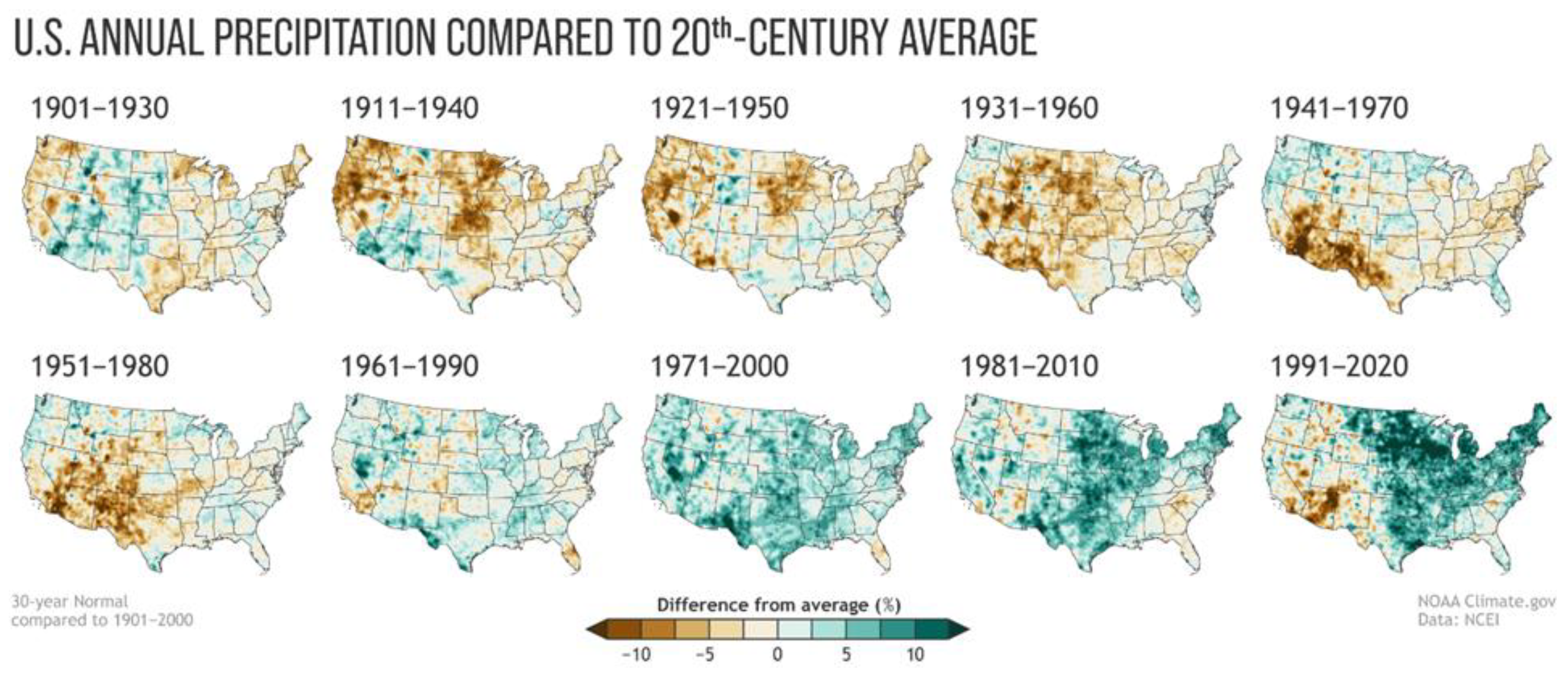
Global temperature rise has been a critical issue related to climate change. The rise in surface temperature results from the increasing emission of greenhouse gases like carbon dioxide (CO2), methane (CH4), nitrous oxide (N2O), and others. NOAA has identified 2023 as the hottest year on record according to its global temperature dataset, which spans back to 1850. There is a one-in-three probability that 2024 will be warmer than 2023 and a 99% probability that 2024 will be among the top five warmest years on record. Due to the impact of climate change, the precipitation pattern in the whole USA has changed drastically. While some states got drier, most of the states have seen more precipitation [16,17]. The average rainfall amounts in different states have shifted significantly. From Figure 1, it is obvious that the precipitation in south-western regions has increased significantly.
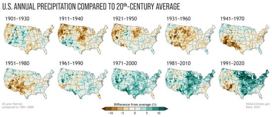
Figure 1.
Normal annual U.S. precipitation as a percentage of the 20th-century average [16].
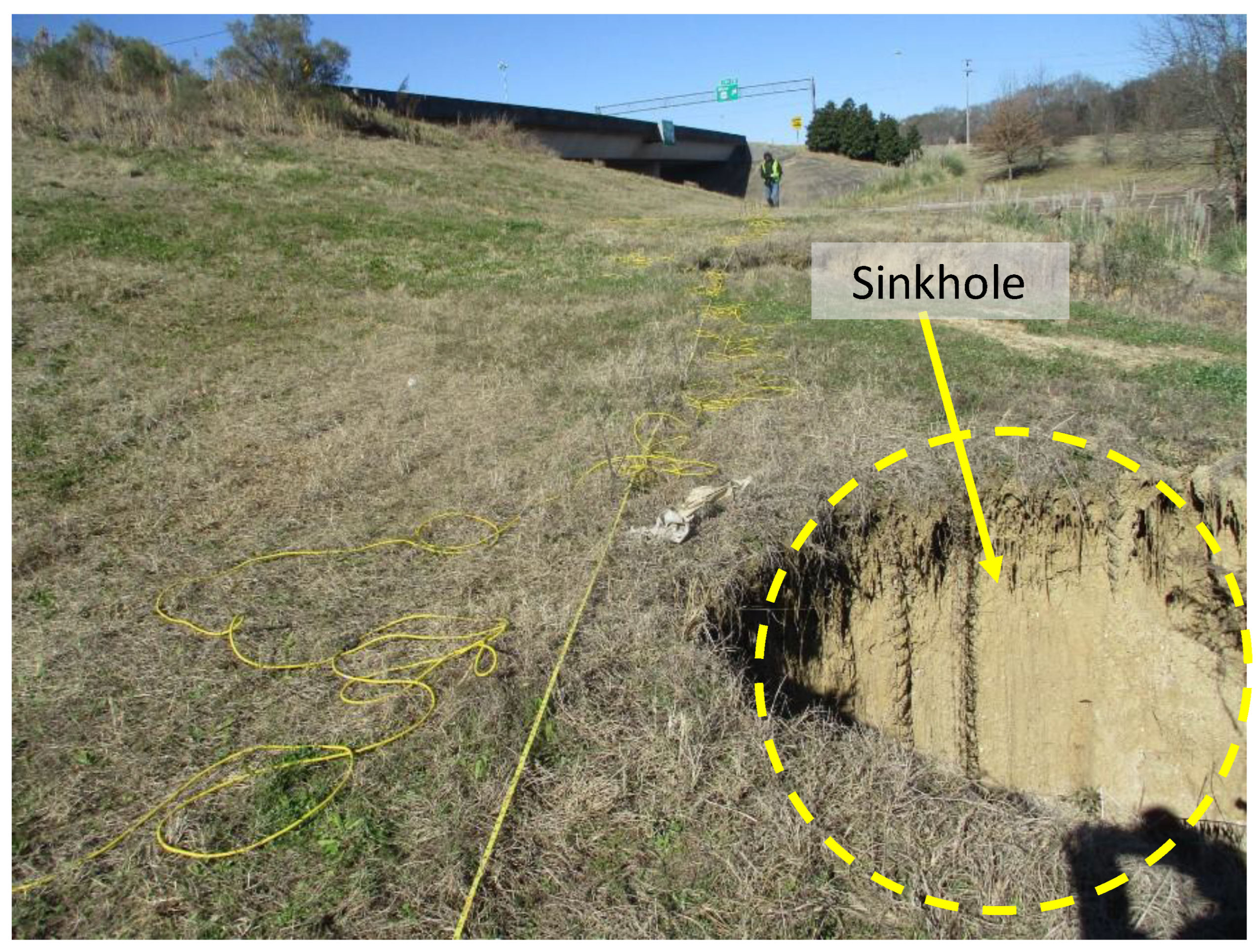
The US Environmental Protection Agency (EPA) emphasized alterations in precipitation patterns due to climate change in the contiguous US, citing a 10–20% shift in precipitation for the mid-western and southeast regions. Analyzing temperature and rainfall trends in selected southern states, projections indicate a rise in temperature followed by increased evaporation. With a 7% rise in the water retention capacity of air per 1 °C warming, this contributes to heightened precipitation during specific weather events such as thunderstorms, extratropical rain, snowstorms, or tropical cyclones [18]. The impact of climate change resulted in an increased frequency of extreme events. Over the last five decades, there has been a 20% rise in the occurrence of exceptionally heavy precipitation in the southeastern plains [19]. In August 2022, Mississippi witnessed six extreme events surpassing the local threshold, meeting the criteria of ‘1-in-1000-year’ rainfall events according to the National Weather Service classification. Within a mere three-hour timeframe on a single day, specific areas in Mississippi encountered rainfall exceeding 8 inches [20]. A study conducted by NASA has revealed that climate change is leading to heightened fluctuations in precipitation patterns. These variations are marked by prolonged dry spells followed by intense storms, which deposit significant rainfall over brief periods. This increase in rainfall affects both slow-moving and fast-moving landslides, demonstrating that heavy precipitation serves as a common trigger for landslides of varying speeds. That is why rainfall-induced slope failure is very common in southern states of the USA, where expansive clay soil is prevalent. The rainwater infiltrates into the slope soil and reduces the matric suction of the slope [21]. The decrease in the matric suction reduces the soil shear strength and leads to a shallow slope failure [22]. In recent years, Mississippi has seen a tremendous increase in rainfall, and creeping slope failure has become a common phenomenon (Figure 2), which causes significant financial loss.
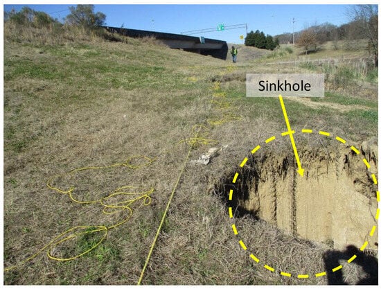
Figure 2.
Sinkhole developed in a slope near Metro Centre, Mississippi, in I220N.
Various mechanical methods have been implemented for stabilizing embankment slope failures, each with its unique characteristics and advantages. One approach involves using tire bales, which are blocks of compressed scrap tires held together by galvanized or steel tie wires [23]. Another effective method utilizes geosynthetics, such as geogrids, geotextiles, or geofoams, known for their flexibility and long-term performance in significantly increasing soil strength. It is important to note that the long-term behavior of geosynthetic materials relies on exposure to various degradation mechanisms [24]. Soil nails represent another technique for reinforcing the soil mass by transferring the tensile and shear resistance to the sliding soil. Retaining structures play a crucial role in slope stabilization by enhancing resisting forces, particularly shear stress, and various types like precast concrete panel walls, cast-in-place concrete gravity and cantilever walls, crib walls, gabion walls, MSE walls, tieback walls, rock walls, and ‘H-pile’ and leggings are employed in highway slope repair initiatives. However, one limitation of retaining structures lies in the necessity for proper engineering design, as their effectiveness depends on adequate design considerations [25]. Recycled Plastic Pins (RPPs) offer a cost-effective solution for slope stabilization, utilizing recycled plastics and waste materials like polymers, sawdust, and fly ash [26]. Piles contribute to slope stability by providing passive resistance against soil lateral forces [27]. In some cases, slope rebuilding involves replacing the failed soil mass and reshaping the slope to its pre-failure state. However, the effectiveness of this method varies depending on the soil type; while compaction generally improves the physical properties of cohesionless soils, it may not necessarily enhance the properties of cohesive soils like clay [28]. The majority of the current mechanical approaches to slope repair involve substantial fieldwork or financial investments. Bioengineering with plants is a technique that employs vegetation to fortify soil on slopes, bolstering shear strength and ultimately improving slope stability [29]. In various biotechnical methods, the rooting systems of plants offer better reinforcement and drainage properties compared to the earthwork involved in mechanical approaches like slope repair, retaining walls, and sheet piles. Additionally, the biotechnical approach tends to lower both construction and maintenance costs [30].
Vetiver grass, a perennial grass, has shown much potential in reducing landslides and slope failure. The fast-growing plant can sustain various soil types, a broad pH range (3.3–12.5), temperatures spanning from −15 °C to 55 °C, and high concentrations of micropollutants. The fibrous root can reach up to 3–4 m within the first year of plantation. It also exhibits resilience to extreme climate variations, fires, and pests without causing adverse effects on the soil [31,32,33]. Thriving in environments challenging for many other plants, this species can be cultivated extensively in marginal lands with minimal maintenance and significantly reduced irrigation needs. The ‘Sunshine’ vetiver genotype has been acknowledged by the United States Department of Agriculture (USDA) Natural Resources Conservation Service (NRCS) as a non-invasive and sterile variant, making it well-suited for cultivation in the United States [34]. Vetiver grass stabilizes the soil by anchoring it with its thick roots, facilitating water drainage from the soil through evapotranspiration and reducing moisture content. The combined effect of the dense and expansive root network resembles the behavior of soil nails commonly employed in civil engineering projects [35]. The root system substantially enhances the soil’s shear strength with increased slope stability by up to 30% [36].
Studies were carried out on analysis concerning the stability of slopes with and without roots. An investigation of the effect that root suction has on the tensile strength of vetiver roots was carried out [9]. Bio-inspired stabilization on levee slopes has been investigated in expansive clay slopes [37,38]. Ng et al., 2020 found that plant growth and spacing had an effect on the hydrological changes that occurred in the soil [39]. Patil et al., 2021 carried out a transient seepage-coupled slope stability analysis under an extreme precipitation event and demonstrated that the slight increase in FOS that was brought about by matric suction induced by root water uptake (RWU) could play a significant role in maintaining the slope’s stability during extreme storm events, particularly in situations where the FOS of the bare slope is close to one [40]. In another study, Patil et al., 2022 found that matric suction created within shallow depths as a result of root water uptake (RWU) contributes to the provision of a buffer that prevents slope failure during lower-precipitation occurrences, though this stabilization effect is no longer present during precipitation that lasts for a prolonged time [41]. However, the impact study of sunshine Vetiver on unsaturated soil properties in high plasticity expansive clay is still limited. In addition to this, there is no study on how Vetiver impacts the unsaturated soil property of a high plasticity expansive soil slope.
In order to detect potential hotspots for slope failure and the performance of the slope, continuous slope monitoring is necessary. Different sensor systems are implemented to track various soil parameters like moisture content, pore water pressure, temperature, rainfall, and others. By translating the sensor data, it enables the authority to predict any landslide risk. However, site accessibility, the installation of sensors with boring, data storage, and collection remain some of the main challenges of this sensor system. Light detection and ranging (LiDAR) is a well-known and accepted remote sensing method. A wide range of applications including volume estimation, the 3D modeling of rockfall geometry, the extraction of structural and geometric details of landslides using terrestrial laser scanning (TLS) data, and the refinement of LiDAR for the automated assessment of structural irregularities have been deployed with this technology [42].
The current study assesses the performance of Vetiver grass planted on a highway slope in terms of reducing moisture content and repairing slope failure. One highway slope in Jackson, Mississippi, was planted with Vetiver, and field instruments to track the precipitation and soil moisture content were installed. The moisture content data showed significant improvement after theVetiver plantation. A LiDAR survey was conducted to compare the slope movement trend. The analysis shows that there was no significant movement in the slope after the stabilization with Vetiver.
2. Materials and Methods
2.1. Site Selection and Plantation
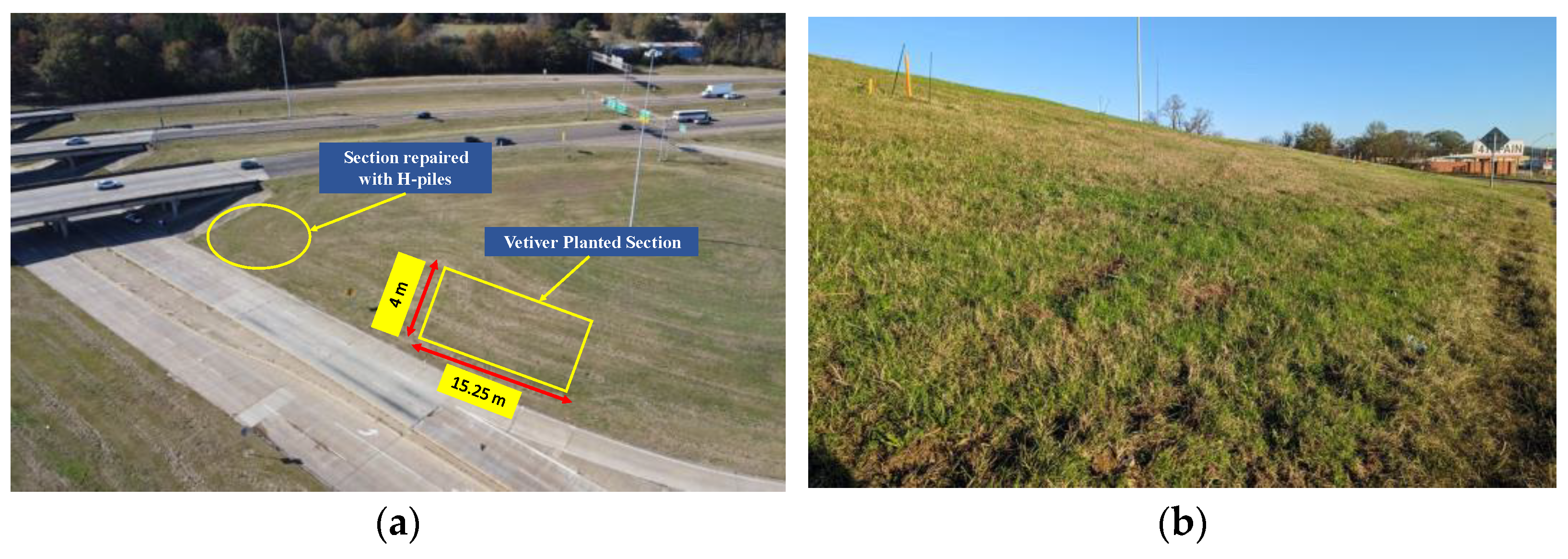
The slope near Terry Road along Interstate I-20 Interchange in Jackson, Mississippi, was selected for the study. The slope soil type is Yazoo clay, characterized as a highly expansive soil with a weathered upper zone overlaying unweathered clays. Weathered Yazoo clay typically exhibits a plasticity index exceeding 50%, attributed to a liquid limit ranging from 70% to 100% and a plastic limit of 20% to 30%. Previous observations [5] indicated signs of slope movement at 1.5 m depth. A section of the slope near the existing bridge experienced a shallow rainfall-induced landslide, which was repaired using H-piles. A study conducted on the impact of rainfall on the slope’s shear strength found that the slope soil exhibited an increased void ratio with an increase in the number of wet–dry cycles. Stability analysis conducted on the representative slope observed a reduced factor of safety due to rainfall events [2]. The slope has a height of 4.572 m and a slope ratio ranging from 3.5H:1V to 4H:1V. The movement of the section without the H-pile was monitored using an inclinometer for one year starting from January 2019. The inclinometer data indicated a movement of up to 1.6 inches at the slope surface for the year 2019 [5]. For reinforcement, a 15.25 m wide section of the slope was chosen, and the ‘Sunshine’ Vetiver grass genotype (Chrysopogon zizanioides or Vetiveria zizanioides) was planted at a spacing of 0.6–0.9 around an area of 65 m2 (Figure 3). The plantation was done at the section where there were no H-piles installed. Due to the tropical character of the grass, planting was conducted to guarantee adequate precipitation, which promotes grass growth. The plantation was done in a staggered way. As the Vetiver root is fibrous enough to spread inside the slope soil, the spacing of 30.48 cm (1 ft) was taken considering the ease of the manual plantation process. It is suggested to plant the Vetiver at the beginning of the rainy season to have sufficient irrigation [43]. Considering this, the plantation was conducted in July 2020 when there was a lot of rainfall in Mississippi. The grass was allowed to grow naturally, and no modifications were made to the surrounding vegetation during the planting process.
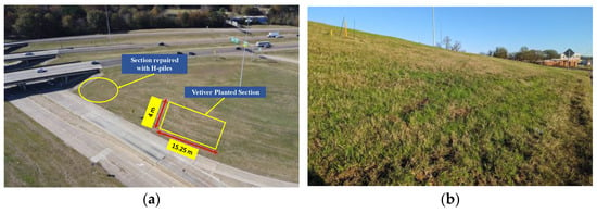
Figure 3.
(a) Location of the study site; (b) Vetiver grass planted on the slope.
2.2. Site Instrumentation and Data Collection
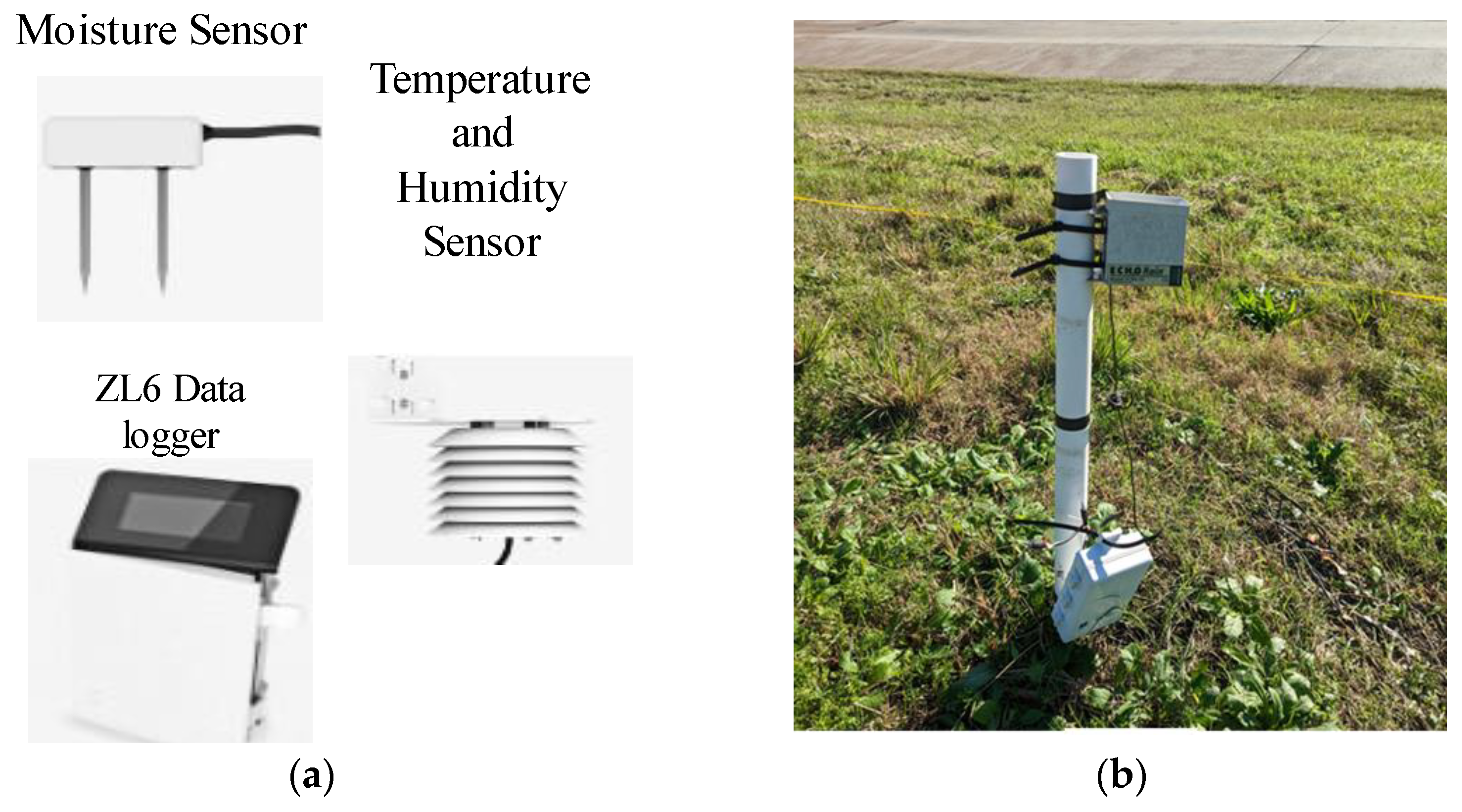
A micro weather station was set up on the study slope to monitor field weather conditions. This installation included the integration of various industrial-grade sensors, such as the GS-1 moisture sensors to measure moisture sensors, the ECRN-50 tipping-bucket rain gauge to track the precipitation, the RT-1 to measure air temperature, and the EM50 data logger (Figure 4). Variations in moisture contents were observed in the planted section up to the depth of Vetiver growth of 300 cm using sensors, with calibrated sensors positioned at depths of 15.24 cm (6 inches) and 45.72 cm (18 inches). The depths were considered to track the slope soil water content, which may induce shallow slope failure. A 3.5 mm stereo audio extension cable is utilized to link each sensor with the data recorders to continuously capture and record in situ measurements. Following the completion of the installation process, the data recorders were programmed to gather information from the soil temperature, rain gauge, moisture sensor, water potential probe, and air temperature sensors hourly. Changes in moisture content and pore water pressure were monitored using these sensors and water probes within the planted section, with sensors placed at depths of 15.24 cm and 45.72 cm. All the sensors were linked to automatic data loggers programmed to collect data at hourly intervals. The data collected from the moisture sensor installed at 45.72 cm were utilized for this study.
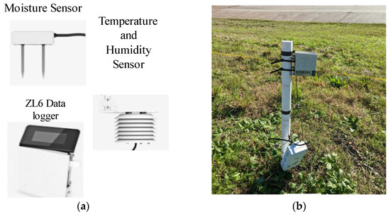
Figure 4.
(a) Different sensors installed at the site; (b) rain gauge to track precipitation of the area.
2.3. LiDAR Survey
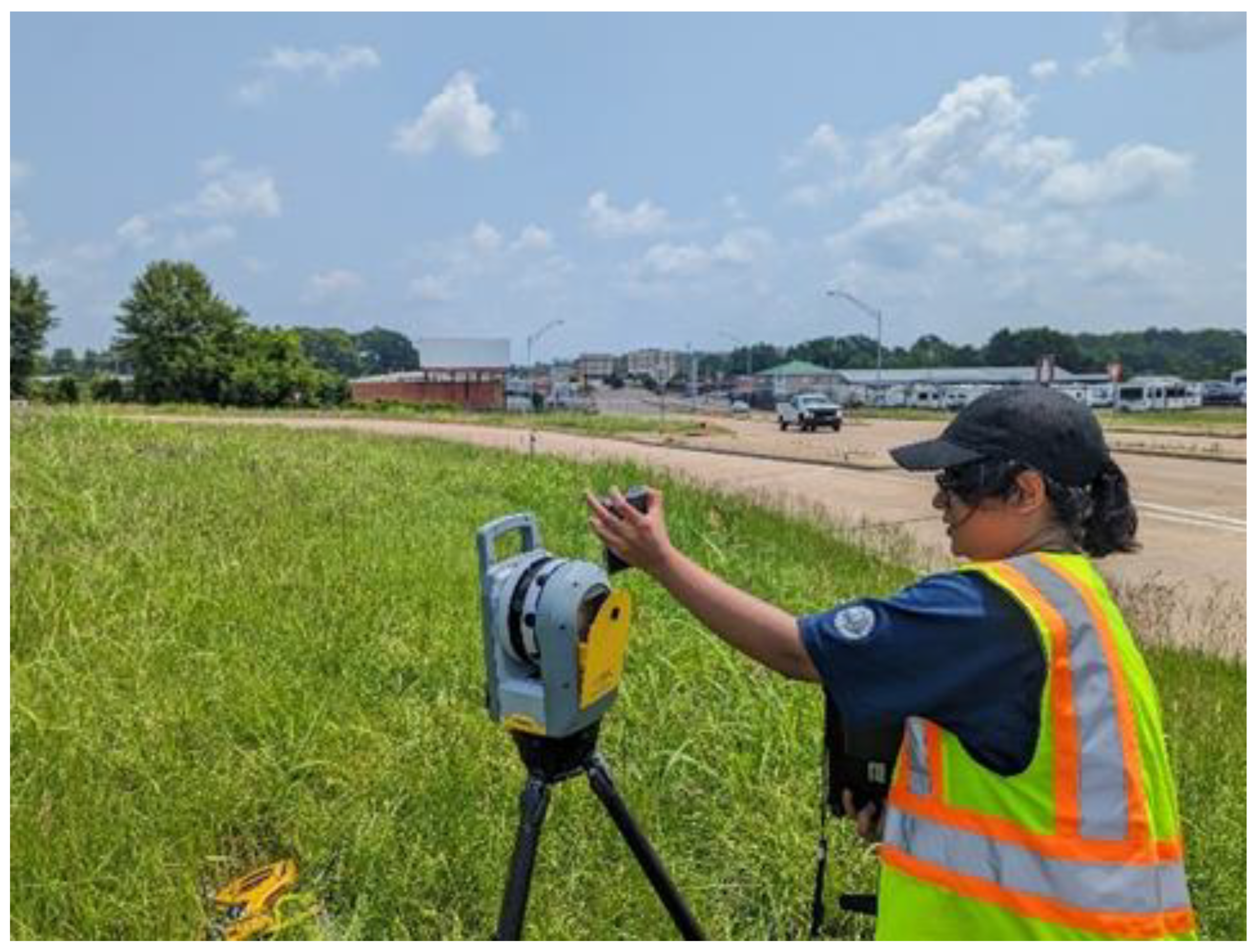
The attractiveness of LiDAR instruments comes from their high spatial and temporal resolution of measurements, the capability to observe the atmosphere under ambient conditions, and the potential to cover the height range from ground level to over 100 km altitude [44]. Conducting recurring LiDAR point cloud surveys at a consistent location over time aids in monitoring subtle changes within geotechnical assets and mapping potential risks [45]. This current study applied 3D laser scanning with the terrestrial LiDAR equipment Trimble X7. Dense point cloud data were captured from the slope, and topographical surfaces were generated using the dense point cloud data, followed by the extraction of bare ground. Temporally spaced surface profiles for both the failed and undamaged sections of the slopes were created for comparative analysis (Figure 5).

Figure 5.
LiDAR survey conducted on the site.
3. Results
3.1. Moisture Content
As part of the process of carrying out the analysis, the information about the moisture content of the slope for the years 2020–21 and 2021–22 was meticulously analyzed. The moisture content of the slope soil was initially higher (about 0.5 m3/m3) (Figure 6a), which may indicate that there is a perched water zone at shallower depth. The moisture content started to decrease in August of 2021, which was more than a year after the plantation was formed.

Figure 6.
Moisture content variations in the slope soil with precipitation. (a) June 2020 to January 2021; (b) May 2021 to February 2022.
In 2020, which was the year that the plantation was carried out, the initial high volumetric moisture content can imply that Vetiver roots were not sufficiently grown to absorb water initially. As the roots started growing in the latter part of the year after August 2021, the water content stayed mostly constant throughout this period. As Vetiver roots can grow to full length up to 3 m after a one-year period, the results imply that the root uptake of the reduced water content reduces the volumetric water content of the soil. The deep root and long leaves of Vetiver allowed a better evaporation rate. There were several events of extreme precipitation during the study period. However, the lower hydraulic conductivity of expansive soil resulted in a delay in the peak in moisture content.
3.2. LiDAR Survey Result
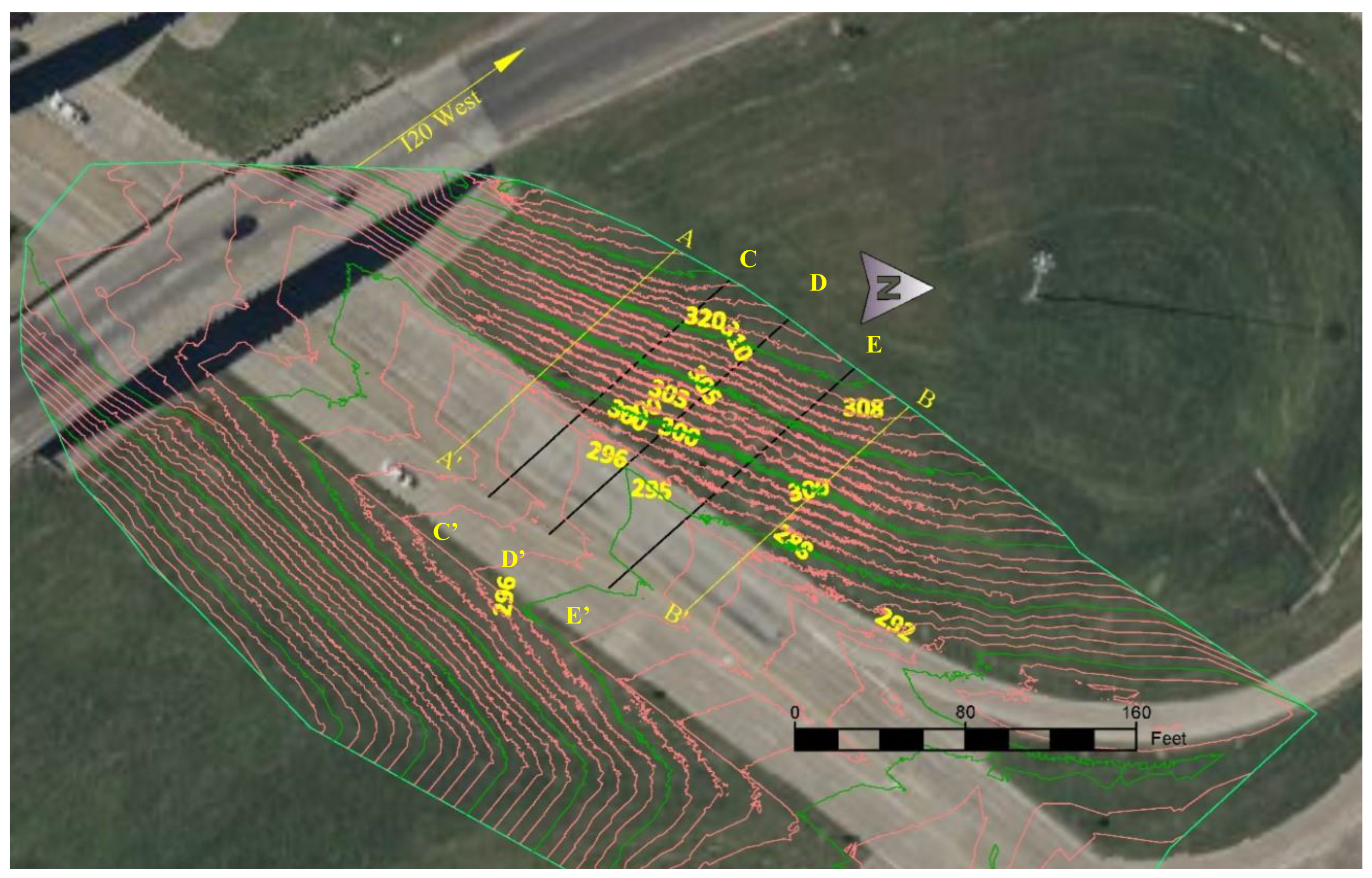
In this study, the Trimble X7 terrestrial LiDAR equipment was utilized to carry out 3D laser scanning. Dense point cloud data were collected for the site and with the collected data, topographical surfaces were constructed. The LiDAR scanner was set up at five different stations on the slope for surveying and point cloud data were gathered while the scanner was in operation. In addition, ten spherical targets were placed around the slope at a height of four feet above the ground to facilitate the registration of the point cloud data that were collected from each station. To compare the temporally spaced point clouds and identify any changes that may have taken place, the point clouds were georeferenced and stacked, respectively. The slope surface profiles for each season were retrieved from the same locations on both point clouds to compare the changes that occurred in the slope during each season.
After field data collection, surface data from each season were superimposed, and alignments were established along the slope. Following this, surface profiles were created by utilizing the alignments along the Vetiver sections C-C’, D-D’, and E-E’ (Figure 7). This process involved superimposing the surfaces to compare the changes over different seasons, and the alignments along the specific sections allowed for the generation of detailed surface profiles in relation to the Vetiver planting areas.
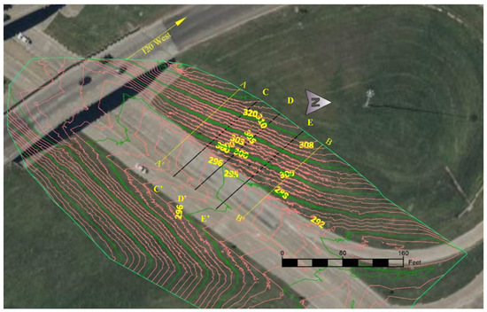
Figure 7.
LiDAR surface topography.
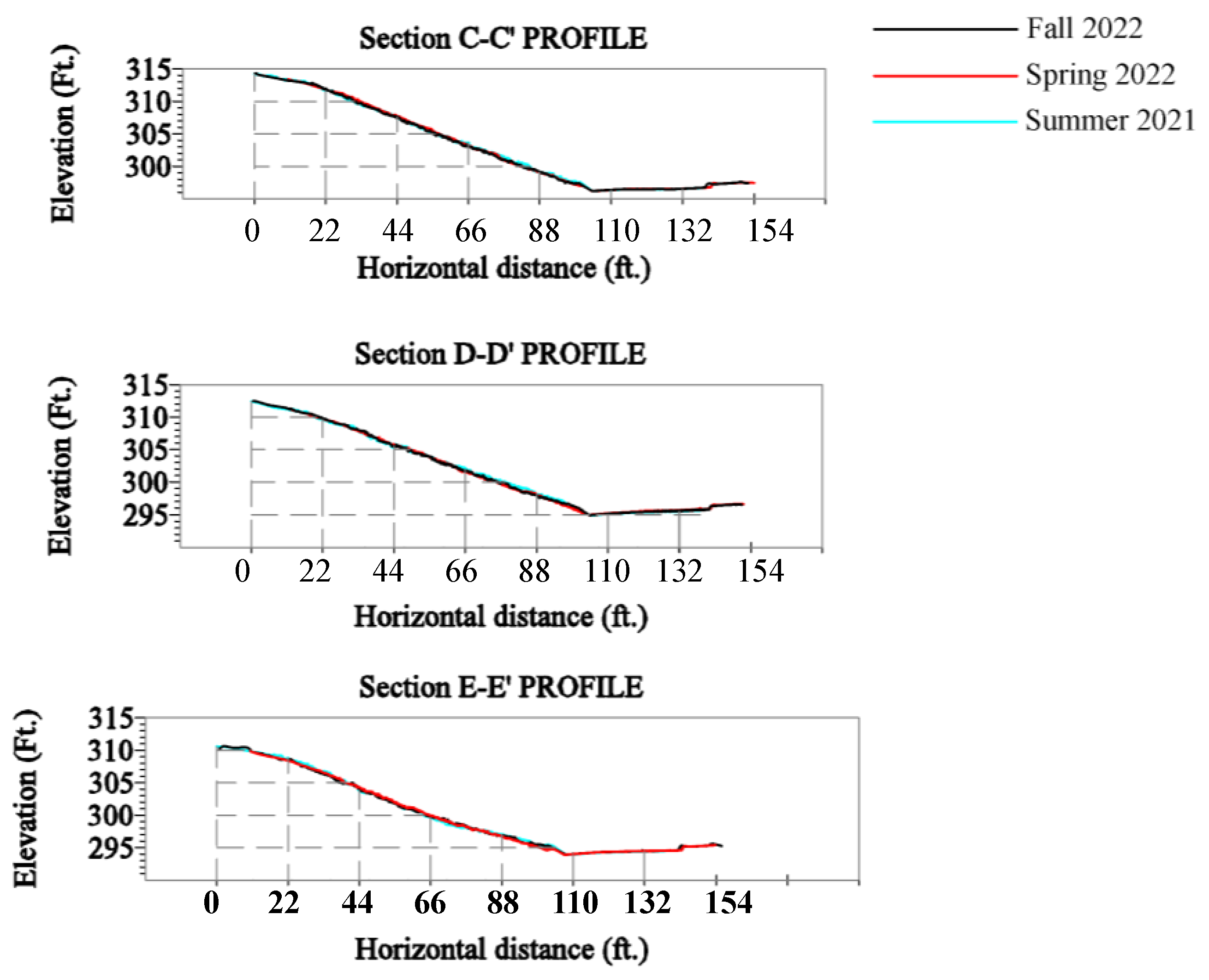
Three sectional profiles were created for summer 2021, Spring 2022, and Fall 2022 (Figure 8).
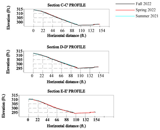
Figure 8.
LiDAR surface profiles for (a) section C-C’, (b) section D-D’, and (c) section E-E’.
After the analysis, the profiles obtained for summer 2021, Spring 2022, and Fall 2022 from the cloud point data were superimposed. There were no significant changes in the slope section with seasonal changes. The profiles from the three sections indicate that there was no slope movement after the plantation of the Vetiver. The Vetiver root helped to lower the moisture content of the slope soil, which increased the shear strength eventually. The increased shear strength prevented any substantial movement along the slope soil.
4. Discussion
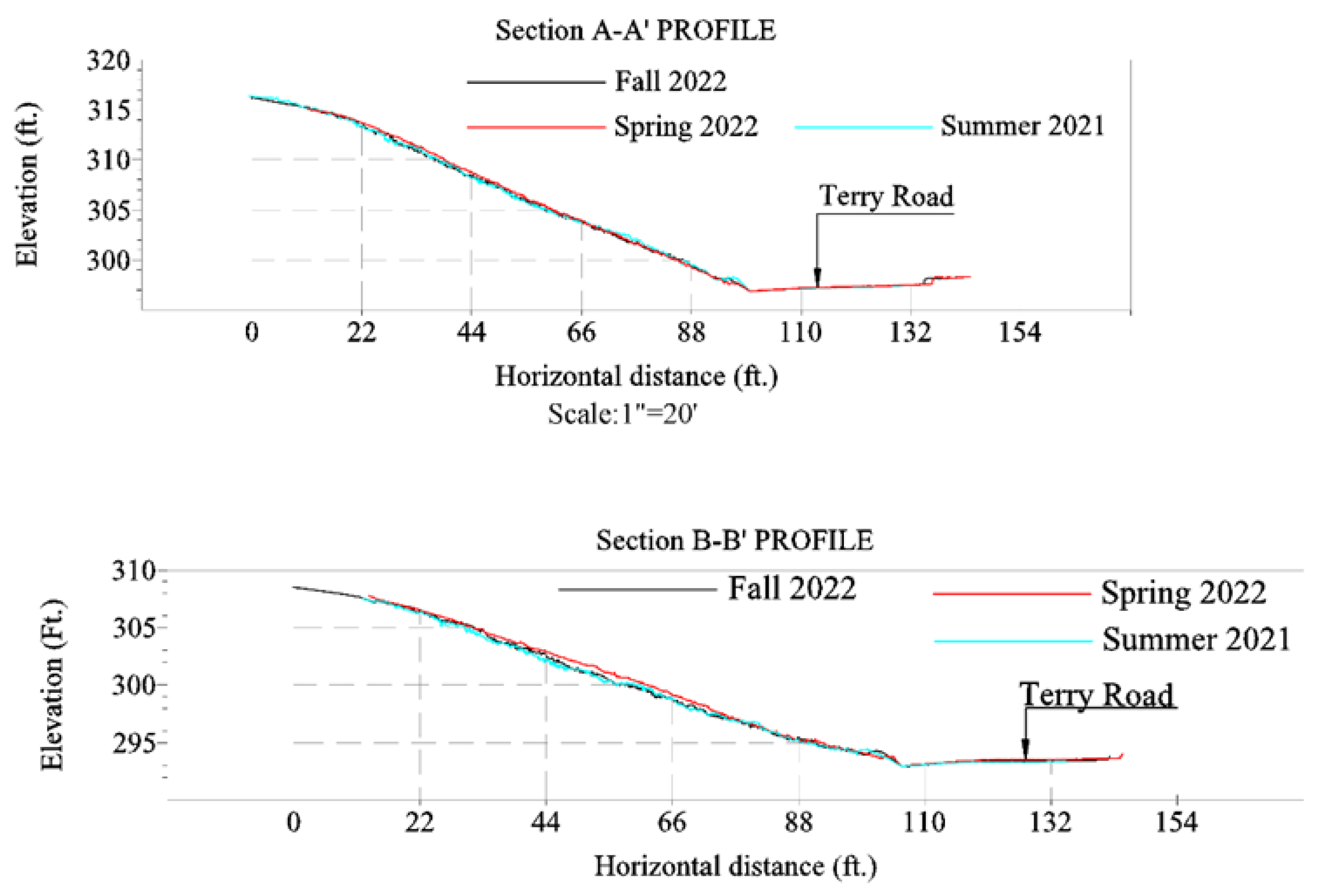
The constant moisture content along the slope soil in 2020 shows the existence of a perched water zone within the slope. The decrease in water content proves the improvement of soil quality after the Vetiver grass grew deeper into the soil. This illustrates the performance of Vetiver in providing slope stability. This was further evaluated through the LiDAR data analysis and surface profile generated from the point clouds. There was no significant change in the soil sectional profile in summer 2021, spring 2022, and fall 2022. It indicates that there was no significant slope movement during this period. The previous repair to the slope where no vetiver exists is still working as intended (Figure 9).
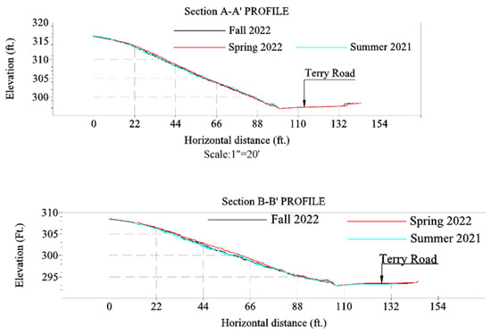
Figure 9.
LiDAR surface profiles for the (up) repaired section A-A’, and (down) control section B-B.
However, in light of recent actions against climate change, the importance of nature-based solutions has been acknowledged significantly. Although the H-piles provided safety against slope movement, the manufacture and installation of H-piles or other similar techniques cost a huge amount of financial investment. On the other hand, Vetiver grass requires very few days to be planted on a highway slope. A single slip of Vetiver only costs USD 2–3 only. If planted in dry seasons, it is recommended to water the plants every 10 days before the plants get matured. There is no need to fertilize when the plant hedges have been established. So, it can be said that Vetiver system needs very little financial costs for operation and maintenance. The deep and fibrous root system can absorb a huge amount of carbon from the atmosphere [46]. Therefore, Vetiver grass provides a comprehensive solution for slope repair that is a cost-effective, climate-adaptive, and nature-based solution.
5. Conclusions
The current study evaluates the performance of Vetiver grass in reducing soil moisture content and preventing slope movement. Highway slopes built on highly expansive clay soil are prone to rainfall-induced failure. Climate change has altered the global temperature and, as a result, the precipitation pattern. Increased rainfall and extreme events have affected the infrastructural health and are causing significant financial loss. One highway slope built on highly expansive Yazoo clay located in Jackson, Mississippi, was selected for the study. The slope previously showed a trend of movement. Field instrumentations to track the moisture content, pore water pressure, and precipitation were installed at the site. Rainfall and moisture content data were collected continuously. A LiDAR survey was conducted in each season to monitor if there was any slope movement. Constant moisture content along the slope soil proves the presence of a perched water zone during the first year of the plantation. However, the moisture content reduced in the second year when the Vetiver grew deeper into the soil. The result from the LiDAR survey also proves the performance of Vetiver in preventing slope movement. There was no significant change in the slope sectional profile between summer 2021 and fall 2022. Vetiver grass demonstrates a significant potential in addressing slope failure, particularly in the southern regions of the USA, such as Mississippi. It offers a cost-effective, climate-adaptive, and sustainable solution for enhancing slope stability. As a nature-based approach, it proactively addresses and mitigates slope failure incidents.
Author Contributions
Conceptualization, F.R. and S.K.; methodology, F.R. and S.K.; validation, F.R., A.C. and S.K.; formal analysis, F.R., A.C. and R.S.; data collection and analysis, F.R., A.C. and R.S.; writing—original draft preparation, F.R.; writing—review and editing, F.R and S.K.; supervision, S.K.; project administration, S.K.; funding acquisition, S.K. All authors have read and agreed to the published version of the manuscript.
Funding
This research was funded by the National Science Foundation, CMMI Award No 2046054.
Data Availability Statement
The data that support the findings of this study are available from the corresponding author upon reasonable request.
Acknowledgments
The authors appreciate the Mississippi Department of Transportation (MDOT) for facilitating the site accessibility required for the study.
Conflicts of Interest
The authors declare no conflicts of interest. The funders had no role in the design of the study; in the collection, analyses, or interpretation of data; in the writing of the manuscript; or in the decision to publish the results.
References
- Allam, M.M.; Sridharan, A. Effect of Wetting and Drying on Shear Strength. J. Geotech. Eng. Div. 1981, 107, 421–438. [Google Scholar] [CrossRef]
- Khan, S.; Ivoke, J.; Nobahar, M. Coupled effect of wet-dry cycles and rainfall on highway slope made of yazoo clay. Geosciences 2019, 9, 341. [Google Scholar] [CrossRef]
- Al-Homoud, A.S.; Basma, A.A.; Husein Malkawi, A.I.; Al Bashabsheh, M.A. Cyclic Swelling Behavior of Clays. J. Geotech. Eng. 1995, 121, 562–565. [Google Scholar] [CrossRef]
- Rao, K.S.; Rao, S.M.; Gangadhara, S. Swelling behavior of a desiccated clay. Geotech. Test. J. 2000, 23, 193–198. Available online: https://trid.trb.org/view/656646 (accessed on 12 December 2023). [CrossRef]
- Khan, S.; Amini, F.; Nobahar, M. Performance Evaluation of Highway Slopes on Yazoo Clay; Mississippi Department of Transportation: Jackson, MS, USA, 2020.
- Spears, A.; Khan, M.S.; Whalin, R.W.; Alzeghoul, O.E.; Chakraborty, A. Bio-Inspired Stabilization of a Test Levee Slope Using Vetiver Grass on Highly Plastic Clay. In Proceedings of the Geo-Congress 2023; American Society of Civil Engineers: Los Angeles, CA, USA, 2023; pp. 96–105. [Google Scholar] [CrossRef]
- Nobahar, M.; Salunke, R.; Alzeghoul, O.E.; Khan, M.S.; Amini, F. Mapping of Slope Failures on Highway Embankments using Electrical Resistivity Imaging (ERI), Unmanned Aerial Vehicle (UAV), and Finite Element Method (FEM) Numerical Modeling for Forensic Analysis. Transp. Geotech. 2023, 40, 100949. [Google Scholar] [CrossRef]
- Prakash, K.; Sridharan, A. Free Swell Ratio and Clay Mineralogy of Fine-Grained Soils. Geotech. Test. J. 2004, 27, 10860. [Google Scholar] [CrossRef]
- Mahannopkul, K.; Jotisankasa, A. Influence of root suction on tensile strength of Chrysopogon zizanioides roots and its implication on bioslope stabilization. J. Mt. Sci. 2019, 16, 275–284. [Google Scholar] [CrossRef]
- Taylor, A.C. Mineralogy and Engineering Properties of The Yazoo Clay Formation, Jackson Group, Central Mississippi. Master’s Thesis, Mississippi State University, Mississippi State, MS, USA, 2005. [Google Scholar]
- Kim, J.; Jeong, S.; Park, S.; Sharma, J. Influence of rainfall-induced wetting on the stability of slopes in weathered soils. Eng. Geol. 2004, 75, 251–262. [Google Scholar] [CrossRef]
- Khan, S.; Amini, F.; Salunke, R.; Nobahar, M. Development of Advanced Landslide Investigation Protocol Using Geophysical Methods for Mississippi; Mississippi Department of Transportation: Jackson, MSA, USA, 2023.
- Li, J.; Cameron, D.A.; Ren, G. Case study and back analysis of a residential building damaged by expansive soils. Comput. Geotech. 2014, 56, 89–99. [Google Scholar] [CrossRef]
- Amakye, S.Y.; Abbey, S.J.; Booth, C.A.; Mahamadu, A.-M. Enhancing the Engineering Properties of Subgrade Materials Using Processed Waste: A Review. Geotechnics 2021, 1, 307–329. [Google Scholar] [CrossRef]
- Jones, L.D.; Jefferson, I. Expansive Soil. In Institution of Civil Engineers Manuals Series; ICE Publishing: London, UK, 2012. [Google Scholar]
- NASA Earth Observatory Climate Changes in the United States. Available online: https://earthobservatory.nasa.gov/images/83624/climate-changes-in-the-united-states (accessed on 13 December 2023).
- NOAA The new, U.S. Climate Normals Are Here. What Do They Tell Us about Climate Change? | National Oceanic and Atmospheric Administration. Available online: https://www.noaa.gov/news/new-us-climate-normals-are-here-what-do-they-tell-us-about-climate-change (accessed on 13 December 2023).
- Trenberth, K. Changes in precipitation with climate change. Clim. Res. 2011, 47, 123–138. [Google Scholar] [CrossRef]
- Karl, T.R.; Melillo, J.M.; Oeterson, T.C. Global Climate Change Impacts in the United States; Cambridge University Press: Cambridge, UK, 2009. [Google Scholar]
- Sistek, S. 6 Rare “1000-Year” Rain Events within a Month? Climate Change May Force NOAA to Update Criteria. Available online: https://www.foxweather.com/extreme-weather/5-rare-1000-year-rain-events-within-a-month-climate-change-may-force-noaa-to-update-criteria (accessed on 25 July 2023).
- Khan, M.S.; Nobahar, M.; Ivoke, J.; Amini, F. Rainfall Induced Shallow Slope Failure over Yazoo Clay in Mississippi. In PanAm Unsaturated Soils; ASCE: Austin, Texas, USA, 2018; pp. 153–162. [Google Scholar] [CrossRef]
- Tohari, A.; Nishigaki, M.; Komatsu, M. Laboratory Rainfall-Induced Slope Failure with Moisture Content Measurement. J. Geotech. Geoenviron. Eng. 2007, 133, 575–587. [Google Scholar] [CrossRef]
- Nabaei, M. Evaluation of Best Practices for implementation of Slope repair Methods in Texas. Master’s Thesis, University of Texas, Arlington, TX, USA, 2019. [Google Scholar]
- Nelson, M.; Saftner, D.; Carranza-Torres, C. Slope Stabilization for Local Government Engineers in Minnesota. In Congress on Technical Advancement; ASCE: Austin, Texas, USA, 2017; pp. 127–138. [Google Scholar] [CrossRef]
- Collin, J.G.; Loehr, J.E.; Hung, C.J. Slope Maintenance and Slide Restoration Reference Manual for NHI 132081 Course 2008; National Highway Institute: Washington, DC, USA, 2008. [Google Scholar]
- Chen, C.-W.; Salim, H.; Bowders, J.J.; Loehr, J.E.; Owen, J. Creep Behavior of Recycled Plastic Lumber in Slope Stabilization Applications. J. Mater. Civ. Eng. 2007, 19, 130–138. [Google Scholar] [CrossRef]
- Wei, W.B.; Cheng, Y.M. Strength reduction analysis for slope reinforced with one row of piles. Comput. Geotech. 2009, 36, 1176–1185. [Google Scholar] [CrossRef]
- Abramson, L.W.; Lee, T.S.; Sharma, S.; Boyce, G.M. Slope Stability and Stabilization Methods, 2nd ed.; John Wiley & Sons, Inc.: New York, NY, USA, 2002. [Google Scholar]
- Gray, D.H.; Sotir, R.B. Biotechnical and Soil Bioengineering Slope Stabilization: A Practical Guide for Erosion Control; John Wiley & Sons, Inc.: New York, NY, USA, 1996. [Google Scholar]
- Martin Donat Bioengineering Techniques for Streambank Restoration; Watershed Restoration Program, Ministry of Environment, Lands and Parks and Ministry of Forests, Umweltakademie: Stockhofstr, Austria, 1995.
- Crocamo, A.; Di Bernardino, S.; Di Giovanni, R.; Fabbricino, M.; Martins-Dias, S. An integrated approach to energy production and nutrient recovery through anaerobic digestion of Vetiveria zizanoides. Biomass Bioenergy 2015, 81, 288–293. [Google Scholar] [CrossRef]
- Mickovski, S.B.; van Beek, L.P.H. Root morphology and effects on soil reinforcement and slope stability of young vetiver (Vetiveria zizanioides) plants grown in semi-arid climate. Plant Soil 2009, 324, 43–56. [Google Scholar] [CrossRef]
- Nirola, R.; Megharaj, M.; Aryal, R.; Naidu, R. Screening of metal uptake by plant colonizers growing on abandoned copper mine in Kapunda, South Australia. Int. J. Phytoremediation 2016, 18, 399–405. [Google Scholar] [CrossRef]
- Samir, S.; Khan, M.S. Water Balance Final Cover Using Vetiver Grass in Texas. Geo-Congress 2023, 2023, 182–192. [Google Scholar] [CrossRef]
- Hengchaovanich, D. Vetiver system for slope stabilization. In Proceedings of the 3rd International Vetiver Conference, Guangzhou, China, 6–9 October 2003; pp. 301–309. [Google Scholar]
- Mohammad, S.N.; Masoud, N.; Mohammad Sadik, K.; Alzeghoul, O.; Henry Kini, C. Vetiver Grass Performance on a Distressed Highway Slope of High-Plastic Clay under Excessive Rainfall. Geo-Congress 2022, 2022, 268–278. [Google Scholar] [CrossRef]
- Khan, S.; Whalin, R.W.; Spears, A.; Chakraborty, A. Bio-Inspired Stabilization of Levee Slope on Expansive Yazoo Clay at the Maritime and Multimodal Transportation Infrastructure in Mississippi. 2023. Available online: https://rosap.ntl.bts.gov/view/dot/73004 (accessed on 15 December 2023).
- Rahman, F.; Chakraborty, A.; Khan, S. A Transformative Approach to Stabilize Highway Slope Using Vetiver Grass. In Proceedings of the ASCE Inspire 2023; American Society of Civil Engineers: Arlington, VA, USA, 2023; pp. 537–545. [Google Scholar]
- Ng, C.W.W.; Ni, J.J.; Leung, A.K. Effects of plant growth and spacing on soil hydrological changes: A field study. Géotechnique 2020, 70, 867–881. [Google Scholar] [CrossRef]
- Patil, U.D.; Shelton, A.J.; Catahay, M.; Kim, Y.S.; Congress, S.S.C. Role of vegetation in improving the stability of a tropical hill slope in Guam. Environ. Geotech. 2022, 9, 562–581. [Google Scholar] [CrossRef]
- Patil, U.D.; Shelton Iii, A.J.; Aquino, E. Bioengineering Solution to Prevent Rainfall-Induced Slope Failures in Tropical Soil. Land 2021, 10, 299. [Google Scholar] [CrossRef]
- Hu, H.; Fernandez-Steeger, T.M.; Dong, M.; Azzam, R. Numerical modeling of LiDAR-based geological model for landslide analysis. Autom. Constr. 2012, 24, 184–193. [Google Scholar] [CrossRef]
- Truong, P.; Van, T.P.; Pinners, E. The Vetiver System for Slope Stabilization, 1st ed.; The Vetiver Network International: Washington, DC, USA, 2008. [Google Scholar]
- Wandinger, U. Introduction to LiDAR. In Lidar: Range-Resolved Optical Remote Sensing of the Atmosphere; Weitkamp, C., Ed.; Springer Series in Optical Sciences; Springer: New York, NY, USA, 2005; pp. 1–18. ISBN 978-0-387-25101-1. [Google Scholar]
- Hata, A.; Wolf, D. Road marking detection using LIDAR reflective intensity data and its application to vehicle localization. In Proceedings of the 17th International IEEE Conference on Intelligent Transportation Systems (ITSC), Qingdao, China, 8–11 October 2014; pp. 584–589. [Google Scholar]
- Singh, M.; Guleria, N.; Prakasa Rao, E.V.; Goswami, P. Efficient C sequestration and benefits of medicinal vetiver cropping in tropical regions. Agron. Sustain. Dev. 2014, 34, 603–607. [Google Scholar] [CrossRef]
Disclaimer/Publisher’s Note: The statements, opinions and data contained in all publications are solely those of the individual author(s) and contributor(s) and not of MDPI and/or the editor(s). MDPI and/or the editor(s) disclaim responsibility for any injury to people or property resulting from any ideas, methods, instructions or products referred to in the content. |
© 2024 by the authors. Licensee MDPI, Basel, Switzerland. This article is an open access article distributed under the terms and conditions of the Creative Commons Attribution (CC BY) license (https://creativecommons.org/licenses/by/4.0/).

