Article

GEOAM: A Holistic Assessment Tool for Unveiling the Geoeducational Potential of Geosites

Department of Geology and Geoenvironment, National and Kapodistrian University of Athens, Panepistimiopolis, 15784 Athens, Greece
*
Author to whom correspondence should be addressed.
Geosciences 2023, 13(7), 210; https://doi.org/10.3390/geosciences13070210
Submission received: 8 June 2023 / Revised: 6 July 2023 / Accepted: 10 July 2023 / Published: 13 July 2023
(This article belongs to the Section Geoheritage, Geoparks and Geotourism)

Abstract

:
A new assessment method named GEOAM (geoeducational assessment method), that will be a useful tool for highlighting the geoeducational and geoethical value of a geosite, is proposed. This method takes into account, initially, 11 criteria, which are grouped into 8 categories. Each criterion addresses a different aspect of the geosite’s potential for promoting sustainable development, environmental management, and education. A simplified scoring system using a scale of 1–5 is used, where each criterion is scored based on the degree to which it is presented or implemented. The method was piloted in eight geotopes of the Kalymnos Island and five geotopes of the Nisyros Island, in the SE Aegean Sea, Greece. The implementation of this assessment method highlighted the geoeducational value of these geosites. Based on the criteria and subcriteria incorporated in GEOAM, this paper discusses GEOAM’s potential to promote sustainable development and rational environmental management by directing educators and stakeholders toward actions that conserve and protect geoheritage for future generations, while also contributing to the economic, social, and cultural development of the surrounding communities. By quantifying the geoeducational potential of geosites and integrating essential concepts such as geoconservation and geoethics, the implementation of this new assessment method can benefit the educational community, tourism industry, and environmental conservation efforts.

1. Introduction

The concept of “geoheritage” refers to geological features, landforms, and natural landscapes that have scientific, educational, cultural, and aesthetic value (e.g., [1]). This idea has been recognized for a long time, but the term “geoheritage” specifically emerged to encompass this concept. The development and promotion of the geoheritage concept gained significant momentum through the efforts of organizations such as the International Union of Geological Sciences (IUGS) and UNESCO [2]. Geoparks, national parks, natural monuments, and protected areas are all examples of geoheritage sites [3,4]. These locations offer important opportunities for scientific research, education, and public enjoyment [5,6]. UNESCO established the first Global Geoparks Network (GGN) in 2004 to promote and support geoparks around the world [3,7].
Geoheritage conservation and management are critical for preserving it, promoting sustainable development, and encouraging environmental stewardship. Recognizing the importance of geoheritage contributes to a better understanding of the Earth’s geological diversity and its role in shaping our planet’s past, present, and future. Geoethics is critical in guiding responsible and ethical geoheritage site management. It entails taking into account the ethical implications of using and preserving these sites, promoting sustainable practices, and ensuring their long-term conservation [8,9].
Geoeducation aims to educate people about the natural and cultural heritage of the Earth, including its geological features and processes [10]. It plays a crucial role in promoting environmental awareness and education, leading to responsible behavior and practices toward the natural environment [11]. Geoheritage, geoeducation, and geoethics are interconnected aspects that contribute to the preservation, education, and ethical management of Earth’s geological heritage [1,12,13]. Together, they promote a holistic and responsible approach to understanding, appreciating, and conserving our planet’s geological diversity [14]. The assessment of geoheritage sites is necessary to ensure their conservation, promote sustainable development, enhance education and awareness, facilitate decision-making and planning, and foster international cooperation. Several assessment tools for evaluating and assessing geoheritage have been developed. The focus, scope, and intended purpose of these tools vary. However, a specialized assessment tool that focuses specifically on the geoeducational potential and ethical values of geosites is still required. The development of such a tool can provide a more comprehensive and tailored approach to evaluating the educational aspects of geoheritage, ensuring that they are used effectively for educational and sustainable development purposes [9,15].
The goal of this paper is to present and introduce GEOAM (acronym for geoeducational assessment method), a new geoheritage assessment tool that aims to quantify the geoeducational potential of geosites and geomorphosites while incorporating important concepts like geoconservation and geoethics. GEOAM offers a standardized and effective assessment tool to guide the design and implementation of appropriate educational programs and initiatives. The GEOAM assessment tool’s goal is to provide accessibility for teachers, education staff, and the public. Through the appreciation and understanding of geoheritage, it promotes sustainable development and environmental management. [16,17].

Literature Review

Quantitative methods for evaluating landscapes and landforms started to emerge in the late 1960s, with English-speaking scientists such as Linton, who focused on evaluating landscapes as natural resources [18], and Fines, who proposed an evaluation method around the same time [19]. In 1969, Leopold published a study on landscape aesthetics [20], followed by Warszyñska’s quantitative methodology in 1970, which evaluated areas of tourist interest [21]. In the late 1990s, innovative evaluation methods based on scientific criteria and geological values appeared [22,23,24]. During the late 20th and early 21st century, several assessment methods related to geological concepts and processes were introduced, including attempts by geological research institutes at both the individual and collective levels.
The following is a brief overview of assessment methods that are commonly used and well-regarded in academic circles. Reynard et al. [25] developed an evaluation method that builds upon earlier methods [26,27,28,29,30]. This method takes into account two main values, scientific and additional, and has twelve subcriteria (outlined in Table 1). The scientific value comprises four subcriteria, while the additional value is divided into three categories: ecological, aesthetic, and cultural values. While this method does not explicitly examine the educational perspective of a geomorphosite, it does analyze concepts such as religious, historical, artistic, bibliographic, and geohistorical significance, as well as economic value, within the cultural value category.
Pereira’s assessment method [28], and its updated version by Pereira and Pereira [29], incorporates three values (Table 2): geomorphological intrinsic value, potential use, and the need for protection. The first value is further divided into five subcriteria, including scientific, geomorphological, ecological, cultural, and aesthetic values. The potential use includes three subcriteria, namely accessibility, visibility, and the utilization of other natural or cultural values. The third value pertains to the need for protection and encompasses two subcriteria: the deterioration and vulnerability of geological interest areas. These two subcriteria were considered innovative for their time. However, this assessment method does not make any mention of the geoeducational perspective.
The De Wever assessment, adopted by a public geological study body in France in 2006, is a method for assessing the geoheritage interest and vulnerability of geological sites [31,32]. The method consists of two criteria: (1) geoheritage interest and (2) vulnerability and the need for protection (Table 3). The geoheritage interest criterion is divided into six subcriteria, which include primary geological interest, secondary geological interest, educational interest, interest in the history of geology, site rarity, and preservation status. These subcriteria are used to evaluate the scientific and educational importance of a geosite. The vulnerability and need for protection criterion is divided into four subcriteria: heritage interest, natural vulnerability, anthropogenic threats, and effective protection. These subcriteria are used to assess the vulnerability of a geosite to damage or destruction caused by both natural and human activities. A number of stars are assigned based on the grading obtained on the geoheritage interest (Table 3). The De Wever assessment distinguishes the evaluation of a site’s educational potential as a separate subcriterion, recognizing the importance of educating the public about geoheritage. As a result, the De Wever assessment offers a comprehensive approach to determining the geoheritage value of geosites and identifying those that require the most protection.
Zouros [33] proposed a new method for determining the intrinsic value of geological sites, consisting of six values and ten subcriteria. The first value is scientific and educational, with four subcriteria: integrity, rarity, representativeness, and exemplarity. Other values include geodiversity, ecological–aesthetic, cultural, threat potential, and the need for protection, which includes two subcriteria: vulnerability and legal protection. The final value is the usability potential, which is comprised of four subcriteria: recognizability, geographical distribution, accessibility, and economic potential (Table 4).
The incorporation of legal protection or protection regimes for geologically significant locations is the method’s fundamental innovation. The importance of conservation measures for geosites that have considerable scientific, educational, cultural, or economic value is emphasized by this approach. Additionally, this method acknowledges the potential threats to geosites and the requirement to gauge their susceptibility to damage or destruction. The Zouros [33] method creates a thorough framework for evaluating the intrinsic value of geosites and determining which ones need to be protected and conserved.
Fassoulas et al. [34] developed a quantitative methodology for assessing geotopes, aiming at the long-term management and conservation of geological heritage. This methodology is based on a set of criteria that considers not only a geotope’s geological and geographical significance, but also its scientific, ecological, cultural, aesthetic, and economic significance.
The method focuses on specific indexes necessary to determine the values regarding tourism, education, and the protection requirements of geotopes. The proposed methodology utilizes a scoring system to estimate the touristic, educational, and protection-need value indexes of each geotope on a scale of 1 to 10, based on the resulting scores for scientific, ecological, cultural, aesthetic, economic, and potential for use criteria (Table 5). This quantitative assessment method allows for the identification of priorities for sustainable tourism development, such as geotourism and educational tourism activities, as well as geotope conservation. This quantitative assessment method provides a comprehensive approach for adequate geoheritage management and protection, which is critical for a territory’s sustainable development.
Vujičić et al. [35] developed a comprehensive geotope evaluation method, namely the GAM model, that takes into account a variety of factors such as scientific, educational, scenic, aesthetic, protection, functional, and touristic values. The methodology is made up of main values and additional values, each with its own set of subcriteria. The primary values are scientific/educational, scenic/aesthetic, and protection, with functional and touristic added values. The results of the evaluation are displayed in a diagram that shows the scores of each subcriterion. Tomić and Božić later modified the method by introducing an importance factor (Im) that considers the opinion of visitors about a geotope (Table 6) [36]. The M-GAM (modified geosite assessment model) developed by Tomić and Božić [36] was widely used by various scientists for the evaluation of geotopes at both European and international levels. The M-GAM method is a successful and widespread tool in academia for evaluating the sustainable management and conservation of geoheritage [37]. The advantage of this assessment method is that it incorporates the perspectives of both experts and visitors [36,38].
The method developed by Brilha [15] is considered a general-purpose method (GP method) aiming at the evaluation of any type of geosite using a range of criteria (Table 7). This method focuses on four parameters to quantify the value of a geosite: scientific value (SV), potential educational use (PEU), potential touristic use (PTU), and degradation risk (DR). To evaluate the scientific value of a geosite, seven criteria are considered, including representativeness, scientific knowledge, rarity, and geological diversity. Twelve criteria are used to evaluate the educational potential use of a geosite, such as vulnerability, accessibility, and didactic potential. For the geotouristic potential assessment, thirteen criteria are used, with the first ten being similar to the educational criteria, and the remaining three taking into account interpretative potential, economic level, and proximity to recreational areas.
In Suzuki and Takagi’s study [39], the evaluation method for geotopes was largely based on two earlier methods [33,40], with a primary focus on assessing their scientific merit. The method involved five core values, each comprising three subcriteria (Table 8). The first value pertained to educational value, which was calculated based on the ease of understanding the geotope’s history, representativeness, and comprehensibility of the information provided at the site. Next, the scientific value was evaluated based on the research significance, clarity, and reliability of the scientific narrative presented in textbooks and other media, as well as the rarity of the geotope within the area. The third value focused on the tourism value, including aesthetic and sensory appeal, as well as other natural and anthropogenic attractions in the surrounding area. Safety and accessibility comprised the fourth value by considering the safety of the geotope and access path, the distance from the information base to the geotope, and the walking time from a transportation stop. Finally, the value of tourist information was assessed, encompassing information panels, electronic resources, brochures, tourist guides, and international useful information resources in multiple languages.
This method emphasized the geoheritage value and geotourism potential of geological areas, contributing to its widespread use and recognition. It has been applied to promote urban geotourism and highlight geoheritage of cities like Segovia in Spain [41] and Athens in Greece [42]. Overall, the method is well-established and effective for promoting urban geotourism and highlighting the geological features and monuments present in urban areas.

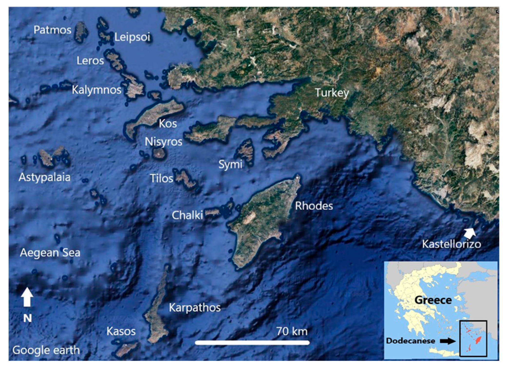
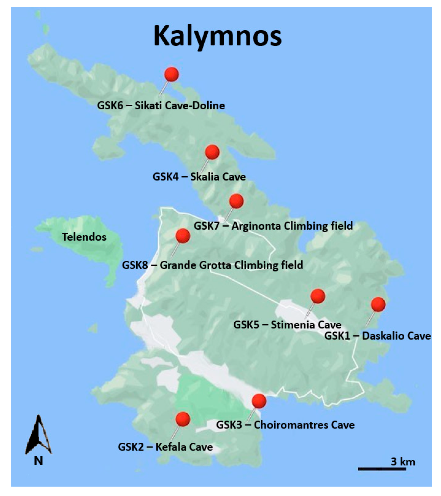
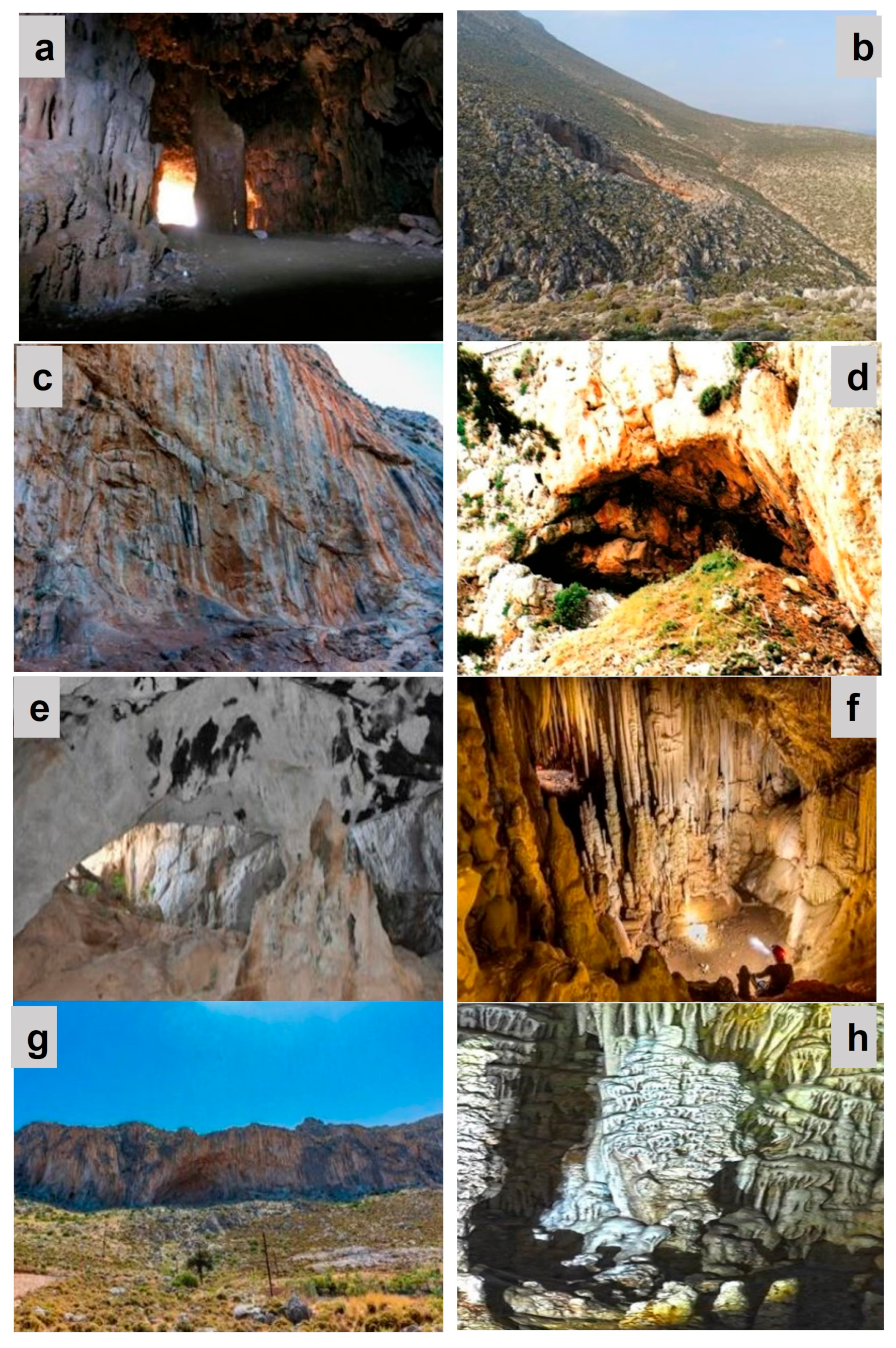
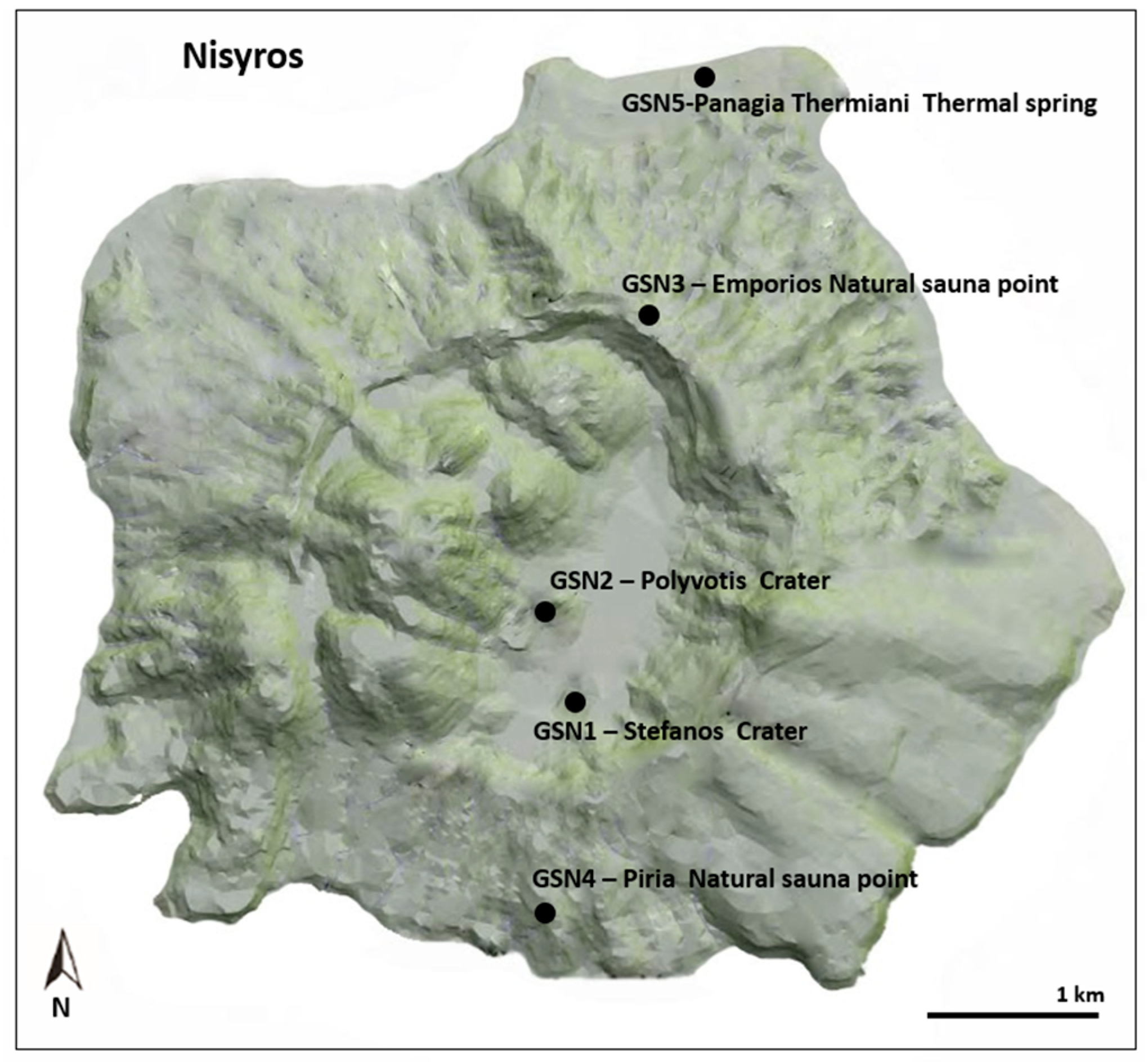
2. Materials and Methods

In order to develop GEOAM, initially, criteria and indicators were identified through the comprehensive literature review analysis to ensure their practicality, measurability, and relevance in assessing the geoeducational potential and ethical values of geosites. The selection of criteria was based on a multidisciplinary approach and careful consideration of the needs and capacities of the target audience.
Once the criteria were identified, a scoring system was developed to assign numerical values to each criterion based on their importance. Various scoring methods, such as binary scoring, numerical scoring, weighted scoring, consensus scoring, or a modified Delphi method, can be used to score the criteria. It is crucial to define the scoring method clearly and ensure consistency across the assessed areas to maintain objectivity and reliability in the assessment tool.
In the case of GEOAM, a simplified scoring system was employed using a Likert scale with a range of 1–5 [43]. Each criterion was scored based on the extent to which it was present or applicable. For example, a score of 1 represented “low presence” or “low implementation”, while a score of 5 denoted “high presence” or “high implementation”. This scoring system provided a nuanced assessment of the geoeducational potential of the site while remaining accessible to non-experts.
Pilot tests were carried out on a number of geosites from the Greek Aegean Sea islands of Nisyros and Kalymnos in order to validate the newly developed assessment method, GEOAM. These preliminary tests served to assess the reliability and accuracy of GEOAM. In order to evaluate the new assessment method’s strengths and weaknesses and highlight opportunities for improvement, a comparison with existing methods was also made.

3. Results

3.1. Criteria Selection and Definition

An evaluation tool is considered objective if it yields consistent and unbiased results regardless of who uses it.
In the case of GEOAM, objectivity can be accomplished through clearly defined criteria, consistent and transparent evaluation procedures, and a regular calibration and validation of the tool’s outputs. Feedback from numerous stakeholders can also help to ensure that the tool remains objective.
The criteria included in GEOAM for the enhancement of the geoeducational potential are accessibility, safety, vulnerability, conservation and protection of natural resources, environmental impact, environmental education and interpretation, cultural and historical significance, community involvement and engagement, economic viability, and sustainable development and geoethics.
The ease with which a geotope can be visited and investigated is referred to as accessibility, and it includes characteristics such as distance from urban centers, transportation alternatives, and the availability of amenities such as trails and restrooms.
Safety relates to the potential risks and hazards associated with visiting a geotope, such as steep terrain, unstable ground, or exposure to extreme weather conditions. Safety concerns are critical for maintaining visitors’ well-being and reducing the danger of accidents and injuries.
The vulnerability criteria refer to a geotope’s vulnerability to external causes such as human activity, climate change, and natural disasters. If a very fragile geotope is not adequately maintained and safeguarded, it might experience damage or be destroyed. The fragility of rock formations, the existence of rare or endangered species, and the possibility of erosion or other environmental disturbances can all contribute to the vulnerability of a geotope.
The conservation and protection of natural resources would evaluate the efforts taken to preserve and protect the natural resources present in the geoheritage site. This encompasses actions performed to reduce the negative environmental impact of human activity.
The environmental impact criterion is used to assess the probable environmental impact of tourism activities on a geotope or geomorphosite, such as travel carbon footprint, waste management, and conservation measures.
The environmental education and interpretation criterion aims to assess initiatives undertaken to educate visitors and the community about the significance of preserving the environment and sustainability. This includes interpretative programs and educational programs that emphasize the site’s unique natural and cultural aspects, while also encouraging environmentally responsible behavior.
The site’s cultural and historical significance should be assessed based on its contribution to local cultural heritage and history.
The criterion for community involvement and engagement takes into account initiatives that involve the local community in decision-making processes, as well as programs that encourage sustainable behaviors within the community.
Economic viability refers to the site’s ability to create revenue for the local economy through sustainable tourism.
The evaluation of the contribution of tourism-related activities to sustainability, including the economic, social, and environmental benefits to local communities, is referred to as sustainable development.
Finally, the geoethics criterion assesses the ethical principles and values associated with the study and management of the Earth’s resources, such as the influence of tourism activities on cultural heritage sites and the conservation of geological features and processes.
These 11 criteria encompass a wide range of characteristics that can contribute to a geotope’s geoeducational potential. Each criterion focuses on a distinct component of the geotope’s potential to promote sustainable development, environmental management, and education. Accessibility, safety, and vulnerability address the practical considerations of making the geotope safe and sustainable for the public. Economic viability and conservation status consider the potential economic benefits of the geotope and the need to protect it for future generations. Environmental impact, educational potential, and community involvement address the educational aspects of the geotope, including its potential to raise awareness about environmental issues, promote scientific understanding, and engage the local community in its management. Sustainable development emphasizes the need to balance environmental, social, and economic considerations when using natural resources, while geoethics considers the ethical implications of geotourism and the management of natural resources.
However, it is important to consider the practicality of using a tool with so many criteria. It may be challenging for educators and other users to assess all 11 criteria for every geotope they visit. Additionally, some criteria may be more important or relevant depending on the context or specific purpose of the assessment.
One possible way to address this is to prioritize or group the criteria into more manageable categories. As a result, accessibility, safety, and vulnerability were grouped under the “site management and visitor experience—(SMVE)” category, while conservation status and environmental impact were placed under the “natural resource management—(NRM)” category. This could help to simplify the assessment process while still capturing the key elements that contribute to a geotope’s geoeducational potential.
It is critical to adjust the criteria to the specific geotope being analyzed, considering its distinctive attributes and context. However, certain criteria, such as accessibility and vulnerability, should be considered even if they do not apply consistently to all geotopes. Even if a geotope is not accessible to the public, the accessibility criterion should be considered in the evaluation. Although the geotope may not be accessible to the public, limiting access may have an impact on the site’s overall geoeducational potential. Other criteria, such as educational potential, conservation status, environmental impact, and community involvement, can be appropriately weighted using the assessment method. A more accurate evaluation can be conducted by taking into account the distinctive characteristics and context of each geotope, ensuring that the criteria correspond to the particular circumstances of the site being evaluated. Rather than using a one-size-fits-all approach, it is critical to evaluate the individual circumstances of each geotope and adjust the evaluation accordingly.

3.2. Grading System

The subsequent phase will involve the evaluation of the geosites based on the selected criteria after grouping them into categories. This entails determining whether each criterion is present or absent and assigning a score based on the degree to which the criterion is present.
It should be emphasized, however, that in cases when a single criterion is too broad and complicated to be evaluated as a whole, the criterion may need to be subdivided into smaller, more specific subcriteria, and then examined independently.
Taking this aspect into consideration, “site management and visitor experience—SMVE” can be graded based on the following subcriteria:
  • Site accessibility: How easy it is to access the site and how well it is connected to other important tourist destinations or transportation hubs.
  • Signage and interpretation: The availability and quality of interpretive materials such as brochures, maps, and signs that help visitors understand the site’s geology and other features.
  • Staff knowledge and visitor interaction: The quality of staff training and the ability of staff to interact with visitors, answer questions, and provide information about the site’s geology and other features.
  • Visitor facilities: The availability and quality of visitor facilities such as restrooms, picnic areas, and trails.
  • Site maintenance: The level of site maintenance and upkeep, including garbage removal, trail maintenance, and facility maintenance.
  • Safety and security: The measures in place to ensure visitor safety, such as warning signs, barriers, and emergency response plans.
To grade “natural resource management—NRM”, the following subcriteria were considered:
  • The conservation of biodiversity, meaning the efforts to conserve and protect the diversity of plant and animal species, including rare or endangered species.
  • The preservation of ecosystems, assessing the efforts to maintain and preserve the natural ecosystems, including forests, wetlands, and other habitats.
  • The sustainable use of natural resources, considering the site’s management practices to ensure the sustainable use of natural resources, such as water, soil, minerals, and timber, and that the resource extraction activities are conducted in a manner that minimizes negative impacts on the environment.
  • Pollution prevention and control, by evaluating the efforts to prevent and control pollution, including air and water pollution, solid waste management, and hazardous waste management.
  • Climate change mitigation and adaptation by evaluating the site’s efforts to mitigate and adapt to the impacts of climate change, including reducing greenhouse gas emissions, implementing renewable energy projects, and promoting sustainable transportation.
“Environmental education and interpretation—EEI” can be evaluated using the following criteria:
  • The presence of interpretive signage or exhibits that provide accurate and engaging information about the site’s natural and cultural history, ecological processes, and conservation practices.
  • The availability of trained interpretive staff or volunteers who are knowledgeable about the site’s resources and are able to provide informative and engaging tours or educational programs.
  • The integration of environmental education and interpretation into the site’s management plan, ensuring that these activities are given adequate resources and support.
  • The inclusion of interactive and hands-on activities that encourage visitors to engage with the site’s natural resources and better understand their ecological and cultural significance.
  • The incorporation of environmentally friendly practices into the site’s operations, such as waste reduction, energy conservation, and the use of sustainable materials.
To grade “cultural and historical significance—CHS”, the following subcriteria were taken into consideration:
  • Historical significance: The historical importance of the site, including its cultural heritage and historical events that have taken place there.
  • Cultural significance: The cultural value of the site, including its significance to local communities and its role in shaping local culture.
  • Interpretation and education: The quality of interpretation and educational programs available at the site, including the provision of educational materials, guided tours, and other forms of interpretive programming.
  • Cultural diversity and inclusivity: The site’s inclusivity and representation of diverse cultural perspectives, including the recognition of underrepresented cultures and marginalized communities.
The “community involvement and engagement—CIE” criterion can be assessed based on how much involvement and engagement by the local community takes place in the geosite’s management, development, and promotion. Some relevant subcriteria for assessing community involvement and engagement are the following:
  • Stakeholder participation refers to the extent of involvement of the local community and other stakeholders in geosite decision-making processes such as management plans, development proposals, and marketing strategies.
  • Cultural sensitivity signifies the extent to which the geosite appreciates and preserves the cultural history and traditions of the local community and engages with them in a culturally sensitive manner.
  • Community benefits are defined as the extent to which the geosite delivers economic, social, and cultural benefits to the local community, such as job development, income production, educational possibilities, and community pride.
  • Outreach and communication, meaning the effectiveness of the geosite in reaching out to and communicating with the local community and other stakeholders, and involving them in the planning, management, and promotion of the site.
To grade “Geoethics–GE”, one approach is to consider the following subcriteria:
  • Environmental impact, which examines whether the site is being managed in a sustainable and responsible manner and implies the analysis of the influence of human activities on the environment and the preservation of natural resources, including aspects such as the quality of air and water, biodiversity, and the overall health of ecosystems.
  • Cultural heritage, which encompasses determining whether the site is being managed in a manner that respects and preserves the cultural heritage of the local community and is merely based on the examination of efforts to safeguard and protect archaeological and historical sites that hold cultural significance.
  • Social responsibility, which refers to the evaluation of the impact of human activities on local communities and assess whether the site is managed in a way that promotes social responsibility, equity, and human rights.
  • Transparency and accountability, which refers to the evaluation of how transparent and accountable the site management is in terms of providing information to the public, engaging with stakeholders, and complying with relevant laws and regulations. It entails determining the public’s degree of accessibility on information about the site’s activities, decisions, and impacts, how effectively stakeholders are included in decision-making processes, and whether the site management complies with legal and regulatory standards.
  • Professional conduct, which entails assessing the conduct and actions of the specialists in charge of maintaining the site. It includes evaluating their adherence to ethical values, ability to navigate conflicts of interest, and adherence to professional regulations and codes of behavior. The assessment focuses on whether the professionals show integrity, honesty, and a dedication to ethical practices in their decision-making and relationships. It also includes evaluating their capacity to maintain objectivity, avoid bias, and conform to the highest professional standards in the field they work in.
The “economic viability–EV” criterion can be graded by taking into account the following subcriteria:
  • Tourist revenue potential: This subcriterion assesses the geosite’s ability to attract tourists and create revenue. It considers factors such as the geosite’s accessibility, attractiveness, and originality.
  • Local economic impact: This subcriterion assesses the geosite’s capacity to contribute to the local economy. It considers features like job creation, revenue generation, and multiplier impacts.
  • Economic benefit sustainability: This subcriterion assesses the long-term viability of the geosite’s economic benefits. It considers aspects such as economic diversification, long-term viability, and potential negative consequences.
  • Management cost-effectiveness: This subcriterion assesses the cost-effectiveness of geosite management in terms of providing economic advantages. It considers aspects such as efficiency, effectiveness, and accountability.
  • Innovative economic models: This subcriterion assesses the geosite’s ability to create novel economic models that encourage sustainable development. It considers aspects like entrepreneurship, social innovation, and environmental innovation.
Lastly, numerous variables can be considered to assess the “sustainable development–SD” of a geosite, including:
  • Resource efficiency: This criterion assesses the effectiveness of resource utilization in geosite management. It determines if the site is managed in a way that reduces the use of resources such as energy, water, and materials, as well as whether these resources are used sustainably.
  • Waste management: This criterion assesses the efficacy of waste management measures at the geosite, such as waste reduction, reuse, and recycling generated by visitors and site operations. It determines if garbage is being managed responsibly in terms of the environment.
  • Biodiversity conservation: This criterion assesses the efforts conducted to protect and manage the geosite’s biodiversity. It determines if the site management plan includes measures for protecting endangered species and habitats, and whether these measures are properly implemented.
  • Social and economic consequences: This criterion assesses the geosite’s social and economic impacts on the neighboring communities. It determines whether the site provides economic advantages to the local community and whether it is managed in such a way that negative social impacts such as relocation or cultural disruption are minimized.
  • Climate change adaptation: This criterion assesses the geosite’s ability for adaptation to the consequences of climate change. It determines whether the site management plan incorporates strategies to adapt to changes such as sea level rise, increased storm severity, or precipitation patterns changes.
  • Cultural heritage preservation: This criterion assesses attempts to preserve the geosite’s cultural heritage. It determines whether or not the site management plan includes measures to protect cultural heritage resources such as archaeological sites or historic structures, and whether or not these measures are effectively implemented.
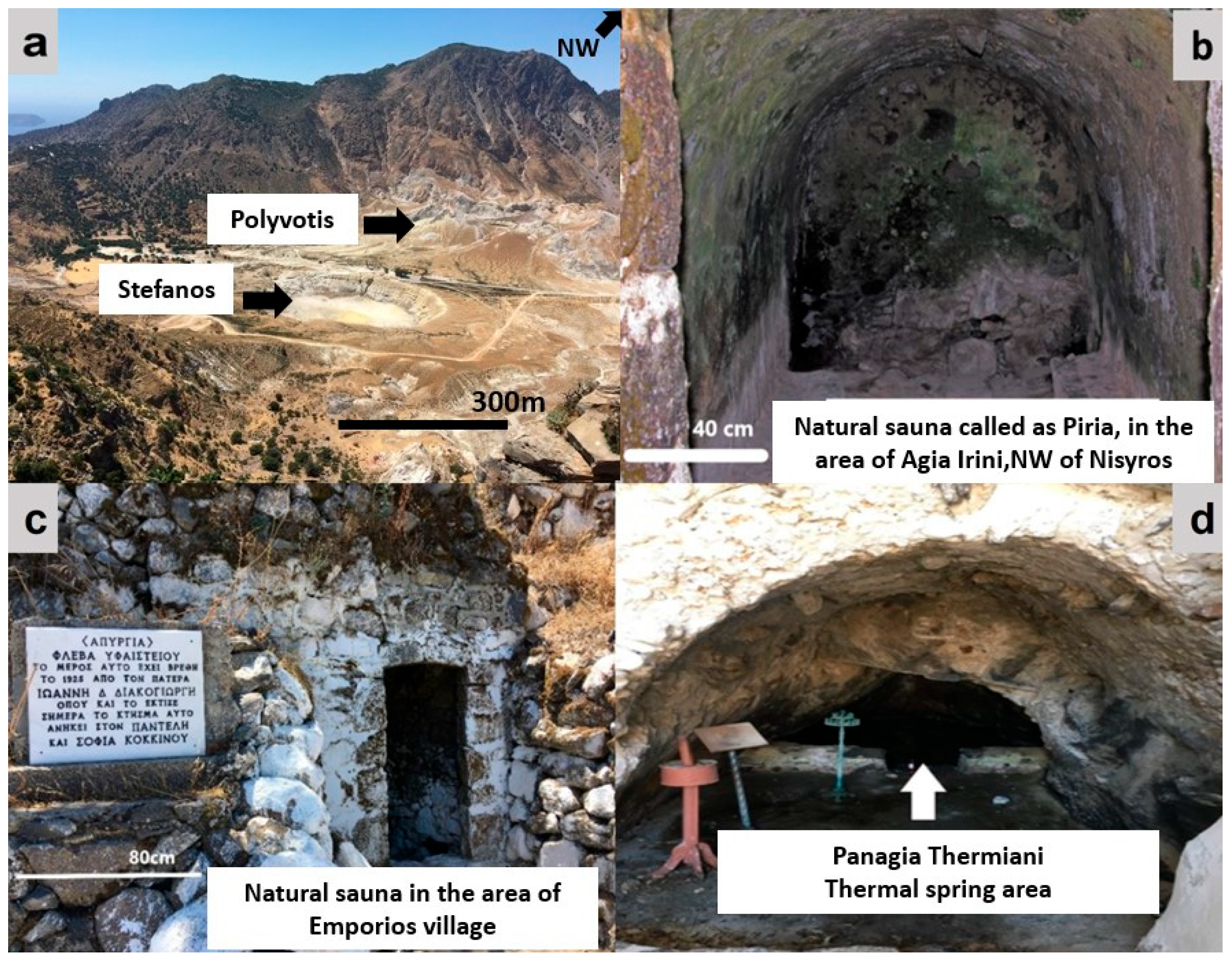
The total score would be determined by the criteria, subcriteria, and grading scale employed in the evaluation. Each criterion in GEOAM is assigned a score upon a 1–5 scale, with each criterion being assessed based on the extent to which it is present or applicable. A score of 1 indicates ‘low presence’ or ‘low implementation,’ whereas a score of 5 indicates ‘very high presence’ or ‘extremely high implementation’ (Table 9). This provides a more elaborate assessment of a geosite’s geoeducational potential and ethical values while remaining accessible to both specialists and non-specialists.
It should be noted, however, that the accurate grading scale used for each criterion can be modified depending on the demands and circumstances of the assessment. The scores for each criterion would then be added together using the weights specified to obtain an overall score. This means that if the grading scale for each criterion ranged from 1 to 5, with 5 being the highest score and 1 being the lowest score, then the overall score for a geotope would be calculated by multiplying each criterion score by its assigned weight, summing the results:
Overall score = [(SMVE × 0.10) + (NRM × 0.10) + (EEI × 0.30) + (CHS × 0.10) + (GE × 0.20) + (EV × 0.05) + (CIE × 0.05) + (SD × 0.10)]
The assignment of weights to each criterion and subcriterion can be enhanced to achieve a greater objectivity using various methods. In our approach, we recruited the assistance of a panel of experts and stakeholders with expertise and experience in geotourism and geoconservation. This panel oversaw determining the significance and applicability of each criterion and subcriterion and then assigning weights based on the results they determined. By involving this diverse group of experts and stakeholders in the process, we obtained a set of weights that incorporates a wide range of perspectives and acknowledges the intricate and multifaceted nature of geotourism and geoconservation.

3.3. Implementation

The initial implementation of GEOAM entails conducting a pilot study to evaluate the methodology on a small scale. This pilot study aims to assess the effectiveness of GEOAM and identify any potential challenges or areas that require improvement before its broader application. By testing the methodology in a controlled and limited setting, we can gather valuable insights and make necessary adjustments to enhance its reliability and usability in future implementations. The first implementation of GEOAM was conducted on the islands of Nisyros and Kalymnos in Greece. Both islands are situated in the southeastern Aegean Sea and are part of the Dodecanese Island complex (Figure 1).
These islands were selected because they have a rich geological and cultural heritage, as well as a significant number of geotopes with different values and characteristics [37,44].
Kalymnos Island is famous for its sponge fishing industry and world-renowned climbing sites. It boasts a rich collection of geotopes, including numerous caves and steep slopes, which hold great potential for attracting visitors. As part of our research, we conducted an analysis of six caves and two climbing sites on the island (Figure 2 and Figure 3) [44].
The island of Nisyros is located in the SE Aegean Sea and is part of the Dodecanese island complex. It is a volcanic island with a complex geological history, featuring volcanic rocks from five different episodes of volcanism. This geodiversity has earned Nisyros a reputation as a geological museum and attracts both geologists and alternative tourists who appreciate its natural beauty. In addition to its volcanic history, the island also boasts hydrothermal craters, the smell of sulfur and fumarolic gases, hot springs, and a rich human history. All these elements combine to make Nisyros a fascinating destination for visitors. In our study, we examined two craters, two natural sauna points, and one thermal spring (Figure 4 and Figure 5) [37].
The implementation of the GEOAM assessment method in the geosites of Kalymnos (GSK) and Nisyros (GSN) on both islands showed the following results (Table 10, Table 11, Table 12, Table 13, Table 14, Table 15, Table 16, Table 17 and Table 18).
Based on the overall scores obtained, it can be deduced that the studied geomorphosites on both the SE Aegean Sea islands and Kalymnos and Nisyros exhibit a relatively high level of geoeducational interest. Indeed, the application of the GEOAM method in the specific contexts of Kalymnos and Nisyros reveals the presence of remarkable geological occurrences and features on these islands. The evaluation of the geomorphosites based on the GEOAM criteria indicates that these sites possess substantial geological value, making them suitable for promoting and conducting various educational activities and initiatives. In the case of Kalymnos, four out of the eight evaluated geomorphosites achieved a high score, three obtained a medium score, and one received a low score. This clear differentiation indicates the presence of significant geological features on the island, presenting ample opportunities to highlight the value of geoheritage through diverse geoeducational activities and initiatives.
Similarly, in the Nisyros area, two out of the five studied geomorphosites displayed a high level of interest, while the remaining three demonstrated medium interest. This observation emphasizes the notable geological potential of the island and reinforces the importance of geoeducation within such environments.
Furthermore, it is important to highlight that a previous study conducted by Zafeiropoulos and Drinia [37,44] evaluated the same geomorphosites using the Brilha method [15]. The final scores and characterization of the studied areas exhibited several similarities, indicating consistency between the two assessment approaches. However, certain exceptions were observed in specific cases. For more comprehensive information, please refer to the detailed table provided below (Table 19).
Regarding the island of Kalymnos, there were similarities in the characterization of five out of the eight geomorphosites when using both methods. However, three geomorphosites exhibited differences between the two assessments. For instance, in Brilha’s method, the GSK1 and GSK6 geomorphosites received a high score, whereas GEOAM assigned them a medium score. Similarly, the GSK3 geomorphosite obtained a medium score in Brilha’s method but a low score in GEOAM.
Shifting our focus to the study area of Nisyros, three out of the five geomorphosites shared a consistent characterization in terms of the final score. However, discrepancies emerged in the evaluation of the GSN3 and GSN5 geomorphosites. Brilha’s method awarded these geomorphosites a high score, while GEOAM assigned them a medium score.
However, the pilot implementation of the new method emphasizes the importance of defining two key axes: the CIE (community involvement and engagement) axis and the EEI (environmental education and interpretation) axis. These axes offer valuable insights into the current state of activities and actions concerning geological matters in the two study areas.
Moreover, it is essential to underline that the scores obtained in the EEI category are significantly low. This indicates a lack of integration of geoeducational activities within the educational community and at the municipal or regional levels. Additionally, the absence of specialized geoeducational staff with the necessary knowledge and expertise is evident. Therefore, it is crucial for the government and society at large to increase awareness and actively promote processes that foster the development of geoeducation and its diverse dimensions.
By doing so, there will be a more systematic and comprehensive dissemination of geoeducational concepts, which will in turn promote geoethical values. This will ensure the conservation and protection of geologically significant areas, as well as the preservation of areas with high cultural and historical value.

4. Discussion

Geosite evaluation plays an essential role in promoting their protection, sustainable development, and educational value [15,45,46,47,48]. In this regard, GEOAM, an innovative assessment tool, provides a targeted method to evaluate the geoeducational potential of geosites and geomorphosites while involving essential geoconservation and geoethics concepts. This approach facilitates a thorough investigation of the educational characteristics of geosites, ensuring their effective utilization for geoeducational objectives and sustainable development [1,38,39,40]. Moreover, it enables consistent evaluation and comparison across diverse geotopes and geomorphosites, thereby supporting decision-making, planning, and fostering international collaboration. Geoconservation and geoethics are included into the assessment process to ensure that the ethical implications of exploiting and protecting geosites are considered, supporting sustainable practices and long-term conservation.
Based on the speculated geoeducational potential, the use of GEOAM may assist in the development of appropriate educational programs and activities. This is beneficial for the development of customized educational activities and the maximization of learning outcomes for visitors and students.
Finally, the goal of GEOAM is to provide a user-friendly assessment tool for teachers, educators, and the general public. This promotes a wider engagement and involvement in the evaluation and utilization of geoheritage sites.

4.1. Challenges and Limitations

While GEOAM offers valuable contributions to assessing the geoeducational potential of geotopes and geomorphosites, it is essential to be aware of its potential limitations and address them through continuous refinement and adaptation. Therefore, depending on the specific criteria and subcriteria employed, GEOAM may entail complexity, necessitating expertise in geology, education, and conservation. This complexity can limit accessibility and use for people without specialized knowledge or training.
Like any assessment tool, there is a degree of subjectivity involved in assigning scores to the different criteria and subcriteria [16,46,49,50,51,52]. The interpretation of the criteria and the weighting of their importance may vary among assessors, potentially leading to inconsistent results [37]. The effectiveness of GEOAM relies on the availability and reliability of data on the geotopes and geomorphosites being assessed. In some cases, obtaining accurate and up-to-date data may be challenging, particularly in remote or less-studied areas.
GEOAM may need to be adapted or customized to suit different geographical and cultural contexts. The specific educational and ethical values associated with geoheritage may vary across regions, requiring flexibility in the application of the assessment tool. It is important to consider how GEOAM aligns and integrates with existing assessment frameworks for geoheritage sites. Ensuring compatibility and synergy with other assessment tools can enhance the overall effectiveness and usefulness of GEOAM.
While there may be challenges regarding complexity, subjectivity in scoring, data availability, adaptability to different contexts, and integration with existing frameworks, these limitations can be addressed through continuous refinement and adaptation.

4.2. Potential Advantages

While the new assessment tool may have some challenges, the potential advantages outweigh the drawbacks, as GEOAM provides a comprehensive assessment of the geoeducational potential of geotopes and geomorphosites and considers important aspects such as geoconservation, geoethics, and the educational value of these sites, providing a holistic understanding of the sites’ educational significance and making informed decisions regarding their management and development.
Moreover, GEOAM offers a standardized approach, implying that the assessment methodology and criteria are well-defined, consistent, and applicable across different locations and contexts in assessing and quantifying the geoeducational potential of sites. This ensures in identifying the best practices and areas for improvement, leading to more targeted efforts in developing educational programs and initiatives.
GEOAM offers the flexibility to be customized and tailored according to the distinct characteristics and needs of different locations and educational settings. This customization capability allows for the inclusion of region-specific criteria and subcriteria, ensuring that the assessment aligns precisely with the local educational values and goals. This ensures that the assessment accurately reflects the educational potential of geotopes and geomorphosites in the specific context being evaluated.
Implementing GEOAM fosters collaboration and cooperation among various stake-holders, including educators, conservationists, local communities, and policymakers. The tool provides a common framework for discussion and engagement, facilitating effective communication and a shared understanding of the educational value and significance of geoheritage sites. It promotes partnerships and collective efforts toward preserving and utilizing these sites for educational purposes.
GEOAM incorporates important principles such as geoethics and geoconservation into its methodology. More specifically, GEOAM includes criteria that cover various dimensions of ethics and sustainability. These criteria evaluate the impact of human activities on local communities, the preservation of cultural heritage, the level of transparency and accountability in site management, and the ethical conduct of professionals involved. By considering these criteria, GEOAM ensures that ethical considerations are an integral part of the assessment process. In addition, GEOAM assesses the sustainable and responsible management of geosites by considering environmental impacts, biodiversity, and the responsible use of natural resources. This promotes the ethical treatment of the environment and encourages practices that minimize negative impacts. Finally, GEOAM evaluates the preservation and protection of cultural heritage, emphasizing the importance of respecting and safeguarding the local community’s heritage. This promotes the ethical treatment of cultural resources and encourages the adoption of sustainable tourism practices that value and preserve cultural heritage [9,13]. Lastly, GEOAM considers the conduct of professionals involved in site management, including their ethical behavior, conflicts of interest, and adherence to professional standards and codes of conduct. This ensures that professionals uphold ethical principles in their work and contribute to the overall ethical framework of geosite assessment and management.
GEOAM incorporates the concept of geoconservation into its methodology by explicitly addressing the conservation and protection of geosites through the inclusion of specific criteria designed to assess their integrity, vulnerability, and overall preservation. Moreover, it involves assessing the overall condition and natural state of geosites, as well as their susceptibility to disturbance or degradation. By considering these factors, GEOAM aims to identify and record the potential risks and challenges that may impact the long-term conservation of geosites. Furthermore, GEOAM examines the measures in place to protect and conserve geological features. This involves evaluating the effectiveness of conservation efforts, including the implementation of management plans, monitoring systems, and mitigation strategies. By assessing these measures, GEOAM ensures that the conservation practices associated with geosites are taken into account during the evaluation process.
GEOAM is designed to be used by a diverse range of stakeholders involved in the assessment and management of geoheritage sites. This includes professionals such as geoscientists and geologists who possess specialized knowledge in the field of geosciences. Their expertise enables them to effectively utilize GEOAM for evaluating the geoeducational potential of geotopes and geomorphosites. By leveraging their understanding of geological features and processes, they can conduct accurate assessments of the educational aspects of these sites.
Furthermore, teachers, educators, and educational institutions can also benefit from using GEOAM to assess the suitability of geotopes and geomorphosites for educational purposes. The assessment results obtained from GEOAM can provide valuable insights into the specific educational potential of these sites. This information can then be used to design educational programs and activities that align with the identified geoeducational potential, ensuring that the learning experiences are tailored to maximize educational outcomes.
By involving both geoscientists and educators in the assessment process, GEOAM facilitates collaboration between experts in the field and professionals involved in education. This interdisciplinary approach ensures a comprehensive evaluation of the geoeducational potential of geoheritage sites and supports the development of impactful educational initiatives [37].
In addition to geoscientists, educators, and educational institutions, professionals and organizations engaged in conservation and environmental management can also benefit from utilizing GEOAM. By using this tool, they can evaluate the educational value of geoheritage sites and integrate educational considerations into their conservation efforts. This holistic approach promotes sustainable practices that take into account the educational dimensions of these sites, fostering a sense of environmental stewardship.
Moreover, GEOAM has practical applications in the realm of tourism and visitor management. Tourism authorities and visitor management organizations can employ GEOAM to assess the educational potential of geotopes and geomorphosites from the perspective of visitor experiences. This assessment aids in designing visitor programs and activities that optimize the educational value for tourists and visitors, enhancing their engagement and understanding of the sites.
Furthermore, local communities and indigenous groups can also utilize GEOAM to evaluate the educational significance of geotopes and geomorphosites within their respective areas. This assessment supports community-based educational initiatives and facilitates the exploration of cultural and historical aspects associated with these sites, fostering a deeper connection and appreciation for their heritage.
While it is important to acknowledge that applying GEOAM may require a certain level of expertise in geology, education, and conservation, efforts can be made to enhance the accessibility of the tool. Providing guidance and training to stakeholders who wish to utilize GEOAM can help bridge knowledge gaps and ensure a wider utilization of the assessment tool across various stakeholder groups. By promoting capacity building and knowledge sharing, GEOAM can become a valuable resource for local communities and indigenous groups to assess and harness the educational potential of their geotopes and geomorphosites, empowering them to actively engage in the preservation and promotion of their cultural and geological heritage.

4.3. Comparison with Other Assessment Tools

The comparison of methods of assessment might be beneficial since it provides an additional perspective, which helps in identifying each tool’s strengths and flaws [37,53]. Comparing different tools can provide insight into their methodologies, criteria, and approaches to assessing the geoeducational and geoethical potential of geosites.
Comparative analyses may highlight tool similarities and differences, allowing users to choose the best tool for specific requirements and objectives. This can also lead to advancements in evaluation procedures by identifying gaps or opportunities for improvement in existing tools.
Furthermore, comparing tools can foster collaboration and knowledge exchange among geoheritage assessment and management scholars, practitioners, and organizations. It enables the exchange of best practices, experiences learned, and innovative ideas, thus enhancing the field.
There are significant analogies and deviations between GEOAM and the assessment method developed by Brilha [15]. Brilha’s method, known as the general-purpose method (G-P method), is intended to assess geosites of diverse types using a variety of criteria. The scientific value (SV) derived from the research area, the potential for educational use (PEU) supplied by the geosite, the potential for tourist use (PTU), and the risk of deterioration (DR) of the area are the four main features that this method focuses on. It is widely acknowledged as one of the most popular and widely used inventory systems in the industry.
GEOAM and Brilha’s assessment tool both attempt to examine and evaluate a site’s geoheritage value. They recognize the necessity of identifying and conserving geological elements of scientific, educational, and cultural values.
GEOAM, on the other hand, is focused on assessing the geoeducational potential of geotopes and geomorphosites, whereas Brilha’s tool is focused on a broader assessment of geoheritage value, covering scientific, educational, and cultural components.
GEOAM’s criteria and subcriteria may differ from Brilha’s assessment tool. While both methods take into account aspects, including scientific significance, educational value, and conservation, the particular elements and weighting of criteria may differ.
GEOAM prioritizes the incorporation of geoethics into the assessment procedure, ensuring ethical considerations in the utilization and preservation of geoheritage sites. Brilha’s tool, on the other hand, may not expressly include a geoethics requirement.
GEOAM also provides a standardized framework for analyzing locations’ geoeducational potential, allowing for consistent evaluation and comparison. Brilha’s assessment tool, on the other hand, may not have the same level of standardization, allowing for a greater flexibility in adjusting the assessment to specific contexts.
GEOAM aims to be accessible to teachers, educational staff, and the general public, encouraging their active participation and engagement. In contrast, Brilha’s tool may have diverse target users or specific considerations regarding accessibility.
It is worth noting that GEOAM is a relatively new assessment approach, whereas Brilha’s assessment tool was published in 2016, meaning that GEOAM may contain recent advancements in geoheritage evaluation methodologies.
Nonetheless, performing a thorough and precise comparison of GEOAM and Brilha’s assessment tool may be difficult without access to specific GEOAM characteristics and documentation. A greater understanding of their particular methodology and specialized criteria is required to completely analyze and evaluate these assessment tools.
While GEOAM and Brilha’s assessment tools are noteworthy, other assessment methods focusing on the geoeducational and geoethical potential of geoheritage may exist. It should be noted that the availability and application of such tools may differ depending on the location and environment in which they are implemented. Researchers, practitioners, and organizations involved in geoheritage evaluation and management are constantly developing and refining assessment methodologies to better capture the educational and ethical components of these sites.

5. Conclusions

GEOAM, as an innovative assessment method, provides substantial advantages and contributes to evaluating the geoeducational potential of geotopes and geomorphosites whilst including fundamental geoconservation and geoethical concepts. It focuses on examining the educational aspects of geosites, assuring their appropriate exploitation for educational purposes and sustainable development.
GEOAM encourages ethical considerations and sustainable practices in exploiting and protecting geosites by integrating geoconservation and geoethical principles, resulting in long-term conservation and responsible conduct.
Furthermore, GEOAM provides a standardized framework for analyzing sites’ geoeducational potential, allowing for consistent evaluation and comparison across various geotopes and geomorphosites. This improves the overall effectiveness and use of the assessment process by facilitating decision-making, planning, and international cooperation.
GEOAM can be applied in directing the development of educational programs and initiatives based on geoeducational potential, allowing for focused educational activities and maximizing educational outcomes for visitors and students.
Furthermore, GEOAM intends to be a user-friendly assessment tool for instructors, educators, and the general public, encouraging a greater engagement and participation in the evaluation and exploitation of geosites.
However, it is essential to consider the potential limitations of GEOAM. These include the complexity of the assessment process, subjectivity in scoring, the availability and reliability of data, adaptability to different contexts, and integration with existing assessment frameworks. Addressing these limitations through continuous refinement, adaptation, and stakeholder engagement is crucial to ensure the ongoing effectiveness and improvement of GEOAM.

Author Contributions

Conceptualization, G.Z. and H.D.; methodology, G.Z. and H.D.; formal analysis, G.Z.; investigation, G.Z.; writing—original draft preparation, G.Z.; writing—review and editing, H.D.; supervision, H.D.; All authors have read and agreed to the published version of the manuscript.

Funding

This research received no external funding.

Data Availability Statement

Not applicable.

Acknowledgments

We wish to thank two anonymous reviewers, whose insightful comments and suggestions significantly helped us to improve our work.

Conflicts of Interest

The authors declare no conflict of interest.

References

  1. Zafeiropoulos, G.; Drinia, H.; Antonarakou, A.; Zouros, N. From Geoheritage to Geoeducation, Geoethics and Geotourism: A Critical Evaluation of the Greek Region. Geosciences 2021, 11, 381. [Google Scholar] [CrossRef]
  2. Kaur, G. Heritage stone subcommission: An IUGS subcommission of the International Commission on Geoheritage. J. Geol. Soc. India 2022, 98, 587–590. [Google Scholar] [CrossRef]
  3. Zouros, N. Global geoparks network and the new UNESCO Global Geoparks Programme. Bull. Geol. Soc. Greece 2016, 50, 284–292. [Google Scholar] [CrossRef] [Green Version]
  4. Frey, M.; Schmitz, P.; Weber, J. Messel Pit UNESCO World Heritage Fossil Site in the UNESCO Global Geopark Bergstrasse-Odenwald, Germany–Challenges of Geoscience Popularisation in a Complex Geoheritage Context. Geoconserv. Res. 2021, 4, 524–546. [Google Scholar] [CrossRef]
  5. Zouros, N.; McKeever, P. European Geoparks: Tools for Earth Heritage Protection and Sustainable Local Development. In European Geoparks; Natural History Museum of the Lesvos: Lesvos, Greece, 2008; pp. 15–30. [Google Scholar]
  6. Martini, G.; Zouros, N.; Zhang, J.; Jin, X.; Komoo, I.; Border, M.; Watanabe, M.; Frey, M.; Rangnes, K.; Vat, T.; et al. UNESCO Global Geoparks in the “World after”: A multiple-goals roadmap proposal for future discussion. Epis. J. Int. Geosci. 2022, 45, 29–35. [Google Scholar] [CrossRef]
  7. Wang, J.; Zouros, N. Educational Activities in Fangshan UNESCO Global Geopark and Lesvos Island UNESCO Global Geopark. Geoheritage 2021, 13, 51. [Google Scholar] [CrossRef]
  8. Di Capua, G.; Peppoloni, S.; Bobrowsky, P.T. The Cape Town statement on geoethics. Ann. Geophys. 2017, 60, 6. [Google Scholar] [CrossRef] [Green Version]
  9. Peppoloni, S.; Di Capua, G. Geoethics and geological culture: Awareness, responsibility and challenges. Ann. Geophys. 2012, 55, 335–341. [Google Scholar] [CrossRef]
  10. Vasconcelos, C.; Orion, N. Earth science education as a key component of education for sustainability. Sustainability 2021, 13, 1316. [Google Scholar] [CrossRef]
  11. Henriques, M.; dos Reis, R.; Brilha, J.; Mota, T. Geoconservation as an emerging geoscience. Geoheritage 2011, 3, 117–128. [Google Scholar] [CrossRef] [Green Version]
  12. Peppoloni, S.; Di Capua, G. Geoethics: Manifesto for an Ethics of Responsibility towards the Earth; Springer Nature: Berlin/Heidelberg, Germany, 2022. [Google Scholar]
  13. Mosios, S.; Georgousis, E.; Drinia, H. The Status of Geoethical Thinking in the Educational System of Greece: An Overview. Geosciences 2023, 13, 37. [Google Scholar] [CrossRef]
  14. Catana, M.; Brihla, J. The role of UNESCO global Geoparks in promoting geosciences education for sustainability. Geoheritage 2020, 12, 1. [Google Scholar] [CrossRef]
  15. Brilha, J. Inventory and Quantitative Assessment of Geosites and Geodiversity Sites: A Review. Geoheritage 2016, 8, 119–134. [Google Scholar] [CrossRef] [Green Version]
  16. Selmi, L.; Coratza, P.; Gauci, R.; Soldati, M. Geoheritage as a Tool for Environmental Management: A Case Study in Northern Malta (Central Mediterranean Sea). Resources 2019, 8, 168. [Google Scholar] [CrossRef] [Green Version]
  17. Peppoloni, S.; Di Capua, G. Geothics: Ethical, social, and cultural implications in geosciences. Ann. Geophys. 2017, 70, 7. [Google Scholar] [CrossRef] [Green Version]
  18. Linton, D.L. The assessment of scenary as a natural resource. Scott. Geogr. Mag. 1968, 84, 218–238. [Google Scholar]
  19. Fines, K.D. Landscape evaluation: A research project in East Sussex. Reg. Stud. 1968, 2, 41–55. [Google Scholar] [CrossRef]
  20. Leopold, L.B. Landscape Aesthetics. Nat. Hist. 1969, 10, 35–46. [Google Scholar]
  21. Warszyñska, J. Evaluation of the village in terms of the tourism attractiveness. Pr. Geogr. 1970, 17, 103–114. [Google Scholar]
  22. Grandgirard, V. Switzerland—The inventory of geotopes of national significance. In Towards the Balanced Management and Conservation of the Geological Heritage in the New Millenium; Sociedad Geológica de España: Madrid, Spain, 1999; pp. 234–236. [Google Scholar]
  23. Giusti, C.; González-Díez, A. A methodological approach for the evaluation of impacts on sites of geomorphological interest (SGI), using GIS techniques. Int. Arch. Photogramm. Remote Sens. 2000, 33, 47–53. [Google Scholar]
  24. Reynolds, J. Notes to Accompany RIGS Recording, Assessment and Designation and Notification Sheets. Notes on the UKRIGS Conference 2001. Penirth: UKRIGS Conference. Available online: https://geoconservationuk.files.wordpress.com/2019/10/assessinfo.pdf (accessed on 7 June 2023).
  25. Reynard, E.; Perret, A.; Bussard, J.; Grangier, L.; Martin, S. Integrated approach for the inventory and management of geomorphological heritage at the regional scale. Geoheritage 2016, 8, 43–60. [Google Scholar] [CrossRef]
  26. Bruschi, V.M.; Cendrero, A.; Quaternario, I. Geosite Evaluation; Can We Measure Intangible Values? Il Quat. 2005, 18, 293–306. [Google Scholar]
  27. Serrano, E.; González-Trueba, J.J. Assessment of geomorphosites in natural protected areas: The Picos de Europa National Park (Spain). Géomorphologie Relief Process. Environ. 2005, 11, 197–208. [Google Scholar] [CrossRef] [Green Version]
  28. Pereira, P.; Pereira, D.; Caetano Alves, M.I. Geomorphosite assessment in Montesinho natural park (Portugal). Geogr. Helv. 2007, 62, 159–168. [Google Scholar] [CrossRef] [Green Version]
  29. Pereira, P.; Pereira, D. Methodological guidelines for geomorphosite assessment. Géomorphologie Relief Process. Environ. 2010, 16, 215–222. [Google Scholar] [CrossRef] [Green Version]
  30. Reynard, E.; Fontana, G.; Kozlik, L.; Scapozza, C. A method for assessing “scientific” and “additional values” of geomorphosites. Geogr. Helv. 2007, 62, 148–158. [Google Scholar] [CrossRef]
  31. De Wever, P.; Le Nechet, Y.; Cornee, A. Vade-mecum pour l’inventaire du patrimoine géologique national. In Mémoire: Hors Série, Société géologique de France; Mémoire Hors Série, n° 12; Sociéte Géologique de France: Paris, France, 2006. [Google Scholar]
  32. De Wever, P.; Alterio, I.; Egoroff, G.; Cornée, A.; Bobrowsky, P.; Collin, G.; Duranthon, F.; Hill, W.; Lalanne, A.; Page, K. Geoheritage, a National Inventory in France. Geoheritage 2015, 7, 205–247.22. [Google Scholar] [CrossRef] [Green Version]
  33. Zouros, N.C. Geomorphosite assessment and management in protected areas of Greece Case study of the Lesvos island—Coastal geomorphosites. Geogr. Helv. 2007, 62, 169–180. [Google Scholar] [CrossRef]
  34. Fassoulas, C.; Mouriki, D.; Dimitriou-Nikolakis, P.; Iliopoulos, G. Quantitative assessment of geotopes as an effective tool for geoheritage management. Geoheritage 2012, 4, 177–193. [Google Scholar] [CrossRef]
  35. Vujičić, M.D.; Vasiljević, Đ.A.; Marković, S.B.; Hose, T.A.; Lukić, T.; Hadžić, O.; Janićević, S. Preliminary geosite assessment model (GAM) and its application on Fruška Gora Mountain, potential geotourism destination of Serbia. Acta Geogr. Slov. 2011, 51, 361–377. [Google Scholar] [CrossRef]
  36. Tomić, N.; Božić, S. A modified geosite assessment model (MGAM) and its application on the Lazar Canyon area (Serbia). Int. J. Environ. Res. 2014, 8, 1041–1052. [Google Scholar] [CrossRef]
  37. Zafeiropoulos, G.; Drinia, H. Comparative Analysis of Two Assessment Methods for the Geoeducational Values of Geosites: A Case Study from the Volcanic Island of Nisyros, SE Aegean Sea, Greece. Geosciences 2022, 12, 82. [Google Scholar] [CrossRef]
  38. Antić, A.; Tomić, N.; Marković, S. Karst geoheritage and geotourism potential in the Pek River lower basin (eastern Serbia). Geogr. Pannonica 2019, 23, 32–46. [Google Scholar] [CrossRef]
  39. Suzuki, D.; Takagi, H. Evaluation of Geosite for Sustainable Planning and Management in Geotourism. Geoheritage 2018, 10, 123–135. [Google Scholar] [CrossRef]
  40. Pralong, J.P. A method for assessing tourist potential and use of geomorphological sites. Géomorphologie Relief Process. Environ. 2005, 11, 189–196. [Google Scholar] [CrossRef]
  41. Vegas, J. El patrimonio geológico de la provincia de Segovia: Geodiversidad y geoconservación. Colección Nat. Y Medio Ambiente 2000, 26, 1–69. [Google Scholar]
  42. Drinia, H.; Tripolitsiotou, F.; Cheila, T.; Zafeiropoulos, G. The Geosites of the Sacred Rock of Acropolis (UNESCO World Heritage, Athens, Greece): Cultural and Geological Heritage Integrated. Geosciences 2022, 12, 330. [Google Scholar] [CrossRef]
  43. Likert, R. A Technique for the Measurement of Attitudes; Archives of Psychology: Akron, OH, USA, 1932. [Google Scholar]
  44. Zafeiropoulos, G.; Drinia, H. Kalymnos Island, SE Aegean Sea: From Fishing Sponges and Rock Climbing to Geotourism Perspective. Heritage 2021, 4, 3126–3146. [Google Scholar] [CrossRef]
  45. Golfinopoulos, V.; Papadopoulou, P.; Koumoutsou, E.; Zouros, N.; Fassoulas, C.; Zelilidis, A.; Iliopoulos, G. Quantitative Assessment of the Geosites of Chelmos-Vouraikos UNESCO Global Geopark (Greece). Geosciences 2022, 12, 63. [Google Scholar] [CrossRef]
  46. Sisto, M.; Di Lisio, A.; Russo, F. Geosite Assessment as a Tool for the Promotion and Conservation of Irpinia Landscape Geoheritage (Southern Italy). Resources 2022, 11, 97. [Google Scholar] [CrossRef]
  47. Georgousis, E.; Savelides, S.; Mosios, S.; Holokolos, M.-V.; Drinia, H. The Need for Geoethical Awareness: The Importance of Geoenvironmental Education in Geoheritage Understanding in the Case of Meteora Geomorphosites, Greece. Sustainability 2021, 13, 6626. [Google Scholar] [CrossRef]
  48. Zafeiropoulos, G.; Drinia, H. A New Quantitative Assessment Method for the Geoeducational Potential of the Geodiversity (No. EGU23-8907). In Proceedings of the EGU General Assembly 2023, Vienna, Austria, 23–28 April 2023. [Google Scholar] [CrossRef]
  49. Gordon, J.E. Geoheritage, Geotourism and the Cultural Landscape: Enhancing the Visitor Experience and Promoting Geoconservation. Geosciences 2018, 8, 136. [Google Scholar] [CrossRef] [Green Version]
  50. Peppoloni, S.; Di Capua, G. The Significance of Geotourism Through the Lens of Geoethics. In Geotourism in the Middle East. Geoheritage, Geoparks and Geotourism; Allan, M., Dowling, R., Eds.; Springer: Cham, Switzerland, 2023. [Google Scholar] [CrossRef]
  51. Antić, A.; Peppoloni, S.; Di Capua, G. Applying the Values of Geoethics for Sustainable Speleotourism Development. Geoheritage 2020, 12, 73. [Google Scholar] [CrossRef]
  52. Chrobak, A.; Novotný, J.; Struś, P. Geodiversity assessment as a first step in designating areas of geotourism potential. Case study: Western Carpathians. Front. Earth Sci. 2021, 9, 752669. [Google Scholar] [CrossRef]
  53. Miljković, Ð.; Božić, S.; Miljković, L.; Marković, S.; Lukić, T.; Jovanović, M.; Bjelajac, D.; Vasiljević, Đ.; Vujičić, M.; Ristanović, B. Geosite Assessment Using Three Different Methods; a Comparative Study of the Krupaja and the Žagubica Springs–Hydrological Heritage of Serbia. Open Geosci. 2018, 10, 192–208. [Google Scholar] [CrossRef]
Figure 1. Satellite photo of the Dodecanese Island complex, SE Greece; inlet: sketch map of Greece indicating the location of Dodecanese Island complex.
Geosciences 13 00210 g001
Figure 2. Satellite map of Kalymnos Island indicating the caves and climbing fields of the study area.
Geosciences 13 00210 g002
Figure 3. (a) Interior of Kefala cave; (b) external view of Sikati doline; (c) Arginonta climbing field; (d) external view of Choiromantres cave; (e) interior of Daskalio cave; (f) a part of the main chamber of the cave Stimenia; (g) view of Grande Grotta climbing field; (h) stalagmites in Skalia cave.
Geosciences 13 00210 g003
Figure 4. Satellite map of Nisyros Island indicating the geomorphosites of the study area.
Geosciences 13 00210 g004
Figure 5. (a) The view of the craters Stefanos and Polyvotis; (b) external view of natural sauna point in the village Emporios; (c) internal view of the natural sauna point in Piria; (d) external view of the thermal spring Panagia Thermiani.
Geosciences 13 00210 g005
Table 1. Assessment method of Reynard et al. [25,30].
Assessment Method of Reynard et al. [25,30]
(Scoring System 0, 0.25, 0.75, 1)
Scientific Value (SV)Additional Value (AV)
Ecological Value (ECOL)Aesthetic Value (AEST)Cultural Value (CULT)
a.Integrity (Int)Ecological impact (Eci)Viewpoints (VP)Religious importance (REL)
Representativeness (Rep)Protected site (PS)Contrasts, vertical development, and space structuration (STR)Historical importance (HIS)
Rarity (Rar) Artistic and literary importance (ART)
Paleogeographic value (Pgv) Geohistorical importance (GEO)
Economic value (ECON)
SV = Int + Rep + Rar + Pgv / 4   AV = ECOL + AEST + CULT / 3
Table 2. Assessment method of Pereira, and Pereira and Pereira [28,29].
Assessment Method of Pereira, and Pereira and Pereira [28,29]
CriteriaAssessment
Geomorphological intrinsic value
(IV)
Scientific (Sc)2—low;
3—medium;
4—high;
5—very high
Other geomorphological values (Ogv)
Ecological (Ec)
Cultural (Cul)
Aesthetic (Ae)
0—nil;
1—very low;
2—low;
3—medium;
4—high;
5—very high
Potential use (PU)Accessibility (Ac)
Visibility (Vi)
Use of other natural or cultural values (Oth)
1—very difficult;
2—difficult;
3—medium;
4—easy/good;
5—very easy/very good
Need for
protection (NP)
Deterioration (De)
Vulnerability (Vu)
1—low;
2—medium;
3—high
Table 3. Assessment method of the national geosite inventorying of France, based on De Wever et al. [31,32].
Assessment Method of the National Geosite Inventorying of France [31,32]
Geoheritage InterestVulnerability and Need for Protection
SubcriterionScaleCoefficientGeoheritage Interest RatingSubcriterionScale
a Primary geological interest0 (Minimal interest)
3 (Remarkable)
4≤100 starHeritage interest0–3 (geoheritage interest star)
Secondary geological interest0 (No interest)
3 (Remarkable
311–201 star (*)Natural vulnerability0 (no threat)
3 (extreme threat)
Educational interest0 (No interest)
3 (Remarkable)
221–302 stars (**)Anthropic threats0 (no threat)
3 (extreme threat)
Interest on the history of geology0 (No interest)
3 (Remarkable)
231–483 stars (***)Effective protection0 (maximum)
3 (complete lack)
Rarity of the site0 (Common)
3 (Rare)
3 Summation12 points in
maximum
Preservation status0 (Poor)
3 (Good)
2
Summation48 points in maximum (scale * coefficient)
Table 4. Assessment method of Zouros [33].
Assessment Method of Zouros [33]
Scientific and educational value
(Ranking 40–0)
Integrity
(10–0)
Rarity
(10–0)
Representativeness
(10–0)
Exemplarity
(10–0)
Geodiversity
(Ranking 10–0)
Ecological and aesthetic value
(Ranking 10–0)
Cultural Value
(Ranking 10–0)
Potential threats and protection needs
(Ranking 10–0)
Legal protection
(5–0)
Vulnerability
(5–0)
Potential for use
(Ranking 20–0)
Recognizability
(5–0)
Geographic distribution
(5–0)
Accessibility
(5–0)
Economic potential
(5–0)
Table 5. Assessment method of Fassoulas et al. [34].
Assessment Method of Fassoulas et al. [34]
Scientific ValueEcological ValueCultural ValueAesthetic ValueEconomic ValuePotential for Use
(Scoring system 1, 2.5, 5, 7.5, 10)
aGeological historyEcological impactEthicsViewpointsVisitorsIntensity of use
RepresentativenessProtection statusHistoryLandscape differenceAttractionImpacts
Geodiversity Religious Official protectionFragility
Rarity Art and culture Accessibility
Integrity Acceptable changes
Table 6. M-GAM assessment method of Vujičić et al. [35] and Tomić and Božić [36].
Assessment Method of Vujičić et al. [35] and Tomić and Božić [36]
(Scoring System 0, 0.25, 0.50, 0.75, 1)
Main Values (MV)Additional Values (AV)
Scientific/Educational (VSE)Scenic/Aesthetic (VSA)Protection (VPr)Functional (VFn)Touristic (VTr)
RarityViewpointsCurrent conditionAccessibilityPromotion
RepresentativenessSurfaceProtection levelAdditional natural valuesOrganized visits
Knowledge of geoscientific issuesSurrounding landscapeVulnerabilityAdditional anthropogenic valuesVicinity of visitors center
Level of interpretationEnvironmental fitting of sitesSuitable number of visitorsVicinity of emissive centersInterpretative panels
Vicinity of important road networkNumber of visitors
Additional functional valuesTourism infrastructure
Tour guide service
Hostelry service
Restaurant service
MV = VSE + VSA + VPr AV = VFn + VTr
Table 7. Assessment method of Brilha [15].
Assessment Method of Brilha [15]
Scoring System 1, 2, 3, 4 (Value of 3 is omitted at SV)
Scientific Values (SV)Potential Educational Use (PEU)Potential Touristic Use (PTU)Degradation Risk (SR)
CriterionWeightWeightCriterionCriterionWeightCriterionWeight
Representativeness3010Vulnerability10Deterioration of geological elements35
10Accessibility10
Key locality205Use limitations5Proximity to areas/activities with potential to cause degradation20
Scientific knowledge510Safety10
5Logistics5
Integrity155Density of population5
Geological diversity55Association with other values5
5Scenery15
Rarity155Uniqueness10Legal protection20
Use limitations1010Observation conditions5
20Didactic potentialInterpretative potential10Accessibility15
10Geological diversityEconomic level5
Proximity of recreational areas5Density of population10
Table 8. Assessment method of Suzuki and Takagi [39].
Assessment Method of Suzuki and Takagi [39]
(Scoring criteria 1, 2, 3, 4)
Ved Education Value
Ved1Ease of understanding the geosite’s story
Ved2Representativeness
Ved3Ease of understanding information panels at the geosite
Vsc Scientific value
Vsc1Research significance
Vsc2Clarity and non-obsolescence of scientific story on information panels, guidebooks, and websites
Vsc3Rarity in the region
Vtr Tourism value
Vtr1Emotional/aesthetic value such as beauty or impressiveness
Vtr2Other natural/anthropogenic values
Vtr3Other tourist attractions in the vicinity
Vsa Safety and accessibility
Vsa1Safety condition of geosite and footpath
Vsa2Travel time from the base (information) point of the area’s attractions
Vsa3Walking time from bus/train stops or parking lot
Vti Value of tourism information
Vti1Information panels of the approach to geosite
Vti2Geosite information on websites, pamphlets, guidebooks, etc.
Vti3International usefulness of information panels and websites (multilingual)
Table 9. Characterization of the final score in GEOAM.
1 < final score < 2Low implementation
2 ≤ final score < 3Medium implementation
3 ≤ final score < 4High implementation
4- ≤ final score < 4.5Very high implementation
From 4.5 up to 5Extremely high implementation
Table 10. Scoring system in the areas of Kalymnos and Nisyros on SMVE.
SMVE—Site Management and Visitor Experience
SubcriteriaGSK1GSK2GSK3GSK4GSK5 GSK6GSK7GSK8GSN1GSN2GSN3GSN4GSN5
Site accessibility3555335555535
Signage and interpretation2525235554323
Staff knowledge and visitor interaction2525225544333
Visitor facilities3535335544434
Site maintenance3525335544434
Safety and security3323233344333
Average2.664.662.664.662.502.834.664.664.334.163.662.833.66
Table 11. Scoring system in the geomorphosites of Kalymnos and Nisyros on NRM.
NRM—Natural Resource Management
SubcriteriaGSK1GSK2GSK3GSK4GSK5 GSK6GSK7GSK8GSN1GSN2GSN3GSN4GSN5
Conservation of biodiversity3333333333333
Preservation of ecosystems3414444444333
Sustainable use of natural resources3424444444333
Pollution prevention and control4424444444333
Climate change mitigation and adaptation2222222233222
Average3.003.402.003.403.403.403.403.403.603.602.802.802.80
Table 12. Scoring system in the geomorphosites of Kalymnos and Nisyros on EEI.
EEI—Environmental Education and Interpretation
SubcriteriaGSK1GSK2GSK3GSK4GSK5GSK6GSK7GSK8GSN1GSN2GSN3GSN4GSN5
Presence of interpretive signage or exhibits1111111111111
Availability of trained interpretive staff or volunteers2313223333222
Integration of environmental education and interpretation2423223333222
Inclusion of interactive and hands-on activities2213222222222
Incorporation of environmentally friendly practices1111111111111
Average1.602.201.202.201.601.602.002.002.002.001.601.601.60
Table 13. Scoring system in the geomorphosites of Kalymnos and Nisyros on CHS.
CHS—Cultural and Historical Significance
SubcriteriaGSK1GSK2GSK3GSK4GSK5 GSK6GSK7GSK8GSN1GSN2GSN3GSN4GSN5
Historical significance5553322255325
Cultural significance5553222244324
Interpretation and education2523222243323
Cultural diversity and inclusivity2312222233222
Average3.504.503.252.752.252.002.002.004.003.752.752.003.50
Table 14. Scoring system in the geomorphosites of Kalymnos and Nisyros on CIE.
CIE—Community Involvement and Engagement
SubcriteriaGSK1GSK2GSK3GSK4GSK5 GSK6GSK7GSK8GSN1GSN2GSN3GSN4GSN5
Stakeholder participation3313225555323
Cultural sensitivity2423224444324
Community benefits3524335555555
Outreach and communication3524225555534
Average2.754.251.753.502.252.254.754.754.754.754.003.004.00
Table 15. Scoring system in the geomorphosites of Kalymnos and Nisyros on GE.
GE—Geoethics
SubcriteriaGSK1GSK2GSK3GSK4GSK5 GSK6GSK7GSK8GSN1GSN2GSN3GSN4GSN5
Environmental impact5525554455333
Cultural heritage3424333344333
Social responsibility3423333344334
Transparency and accountability2423224444323
Professional conduct3323224444333
Average3.204.002.003.603.003.003.603.604.204.203.002.803.00
Table 16. Scoring system in the geomorphosites of Kalymnos and Nisyros on EV.
EV—Economic Viability
SubcriteriaGSK1GSK2GSK3GSK4GSK5GSK6GSK7GSK8GSN1GSN2GSN3GSN4GSN5
Tourist revenue potential4324325555334
Local economic impact4423335555434
Sustainability of economic benefits3433334444333
Cost-effectiveness of management3423334444323
Innovative economic models3523335555434
Average3.404.002.203.203.002.804.604.604.604.603.402.803.60
Table 17. Scoring system in the geomorphosites of Kalymnos and Nisyros on SD.
SD—Sustainable Development
SubcriteriaGSK1GSK2GSK3GSK4GSK5GSK6GSK7GSK8GSN1GSN2GSN3GSN4GSN5
Resource efficiency3434444444444
Waste management3323333333323
Biodiversity conservation3333333333333
Social and economic impacts4524335555434
Climate change adaptation1111111111111
Cultural heritage preservation3434334444333
Average2.833.332.333.162.832.833.333.333.333.333.002.663.00
Table 18. Scoring system in the geomorphosites of Kalymnos and Nisyros on final score.
Final Score and Classification
CriteriaWeightGSK1GSK2GSK3GSK4GSK5GSK6GSK7GSK8GSN1GSN2GSN3GSN4GSN5
SMVE10%2.664.662.664.662.52.834.664.664.334.163.662.833.66
NRM10%33.423.43.43.43.43.43.63.62.82.82.8
EEI30%1.62.21.22.21.61.622221.61.61.6
CHS10%3.54.53.252.752.2522243.752.7523.5
CIE5%2.754.251.753.52.252.254.754.754.754.75434
GE20%3.2423.6333.63.64.24.232.83
EV5%3.442.23.232.84.64.64.64.63.42.83.6
SD10%2.833.332.333.162.832.833.333.333.333.3332.663
Final Score2.623.461.983.112.442.433.123.123.433.392.672.352.75
Characterization of scoreMIHILIHIMIMIHIHIHIHIMIMIMI
HI = High implementation; MI = medium implementation; LI = low implementation.
Table 19. Comparison between GEOAM and Brilha’s method.
GeomorphositesCharacterization of Final Score
GEOAMBrilhas’ Method
GSK1Medium implementationHigh
GSK2High implementationHigh
GSK3Low implementationModerate
GSK4High implementationHigh
GSK5Medium implementationModerate
GSK6Medium implementationHigh
GSK7High implementationHigh
GSK8High implementationHigh
GSN1High implementationHigh
GSN2High implementationHigh
GSN3Medium implementationHigh
GSN4Medium implementationModerate
GSN5Medium implementationHigh
Disclaimer/Publisher’s Note: The statements, opinions and data contained in all publications are solely those of the individual author(s) and contributor(s) and not of MDPI and/or the editor(s). MDPI and/or the editor(s) disclaim responsibility for any injury to people or property resulting from any ideas, methods, instructions or products referred to in the content.

