Article

Geodynamic ‘Hotspots’ in a Periglacial Landscape: Natural Hazards and Impacts on Productive Activities in Chilean Fjordlands, Northern Patagonia

by
María-Victoria Soto
1,2,*,
Joselyn Arriagada-González
1,
Martina Molina-Benavides
3,
Misael Cabello
3,
Miguel Contreras-Alonso
1,
Ignacio Ibarra
1,
Gabriela Guevara
4,
Sergio A. Sepúlveda
2,5,6 and
Michael Maerker
7,8,*
1
Department of Geography, University of Chile, Santiago 8331051, Chile
2
CITRID, Risk Reduction and Disaster Program, University of Chile, Santiago 8331051, Chile
3
Physical Geography Laboratory, Department of Geography, University of Chile, Santiago 8331051, Chile
4
Postgraduate School, Faculty of Architecture and Urbanism, University of Chile, Santiago 8331051, Chile
5
Institute of Engineering Sciences, University of O’Higgins, Rancagua 2820000, Chile
6
Department of Geology, University of Chile, Santiago 8331051, Chile
7
Department of Earth and Environmental Sciences, University of Pavia, 27100 Pavia, Italy
8
Leibniz Centre for Agricultural Landscape Research, Working Group on Soil Erosion and Feedbacks, Eberswalder Str. 84, 15374 Müncheberg, Germany
*
Authors to whom correspondence should be addressed.
Geosciences 2023, 13(7), 209; https://doi.org/10.3390/geosciences13070209
Submission received: 17 January 2023 / Revised: 26 April 2023 / Accepted: 12 May 2023 / Published: 12 July 2023
(This article belongs to the Section Natural Hazards)

Abstract

:
In this paper, we study natural hazards and their potential impacts on productive activities in the Comau Fjord in Chilean Northern Patagonia. We carried out hazard mapping to identify areas with evidence of geomorphological activity on slopes in terms of landslides, river/tsunami flooding, and glacial retreat. The assessment of different geomorphic processes was carried out by both detailed fieldwork and analysis of satellite remote sensing and aerial photography information. We identified terrain units that are subject to multi-hazards overlapping different spatially distributed hazard maps. This information was overlaid with spatial data of economic activities in the area in order to establish the impacts of the natural hazards on the local salmon and mussel farming infrastructure (risk). The results suggest significant exposure levels for these productive activities and potential damage due to the occurrence of natural hazards. The extension of a major highway (CH-7 Austral Highway) on the east coast of the Comau Fjord will be a new incentive for economic development in the area. However, the highway construction sites show a high level of exposure to natural hazards, especially floodings and landslides. Our study highlights that the geohazard potential might have a high negative impact on future productive activity in the fjord as well as on the new highway infrastructure.

1. Introduction

In this study, we use the concept of ‘hotspots’ following [1] indicating geomorphological situations where change may be especially rapid in onset and marked in degree. We extend this connotation to areas where an overlap of different processes may lead to an increased hazard.
Studies on natural hazards and their associated risks are reaching the attention of present-day research more and more because they have significant social implications worldwide. Natural hazards are related to the potential loss of human lives and infrastructure, causing substantial social and economic costs [2,3]). Such losses and costs increased during the last two decades in Latin America [4]. However, the risks created by natural hazards are often undesirable side effects of economic growth, especially if the natural hazards are not considered in planning stages and subsequent construction activities of agricultural, industrial, settlement, and communication infrastructures [5,6,7]. Current climate variability and future climate change constitute new challenges in the study of natural hazards. Hence, it is necessary to incorporate future climate dynamics and their geomorphological implications into the predictive models of hazards and risks, adapting them to global change scenarios [8,9,10,11,12].
Territorial systems and social structures are continuously changing and interacting within the time/space framework. Thus, risk analysts study such interactions in detail, taking into account the effects on the global, regional, and local economy. The analysis of impacts on economic activities should be conducted in the context of the increasing frequencies and magnitudes of natural disasters around the world, that in turn are intensified due to the dynamics of globalization [3].
The development of economic activities resulted in an increasing utilization of remote territories. However, these territories often lack infrastructural connectivity. The cluster of salmon farms in Northern Patagonia in Chile is an example of this phenomenon [13,14,15,16,17].
Chilean Northern Patagonia is a fjordland comprising terrestrial and marine environments that are highly complex systems from a climatic, ecological, and hydrological point of view. However, the area is also subject to human interventions that in turn are affected by climate change [18]. Generally, glacial and periglacial environments are geomorphological systems that are particularly sensitive to climatic changes [19] especially where the marine influence is striking.
Within this context, we analyze the potential effects of natural hazards and the fragility of the existing productive activities in the Comau Fjord, characterized by the presence of small fishing coves, aquacultural farms, and emerging tourism activities.
The construction of a new segment of the national highway, the CH-7 Austral Highway, will further foster and reinforce these economic activities in the area (Figure 1). Moreover, the highway construction will increase population growth due to a facilitated connectivity of the remote areas and is part of an important international infrastructure network. The development dynamics related to globalization and the expansion of transport networks will result in a reconfiguration of the study area and will come along with new hazard and risk scenarios.
Therefore, we assess in this study the geohazards in the Comau Fjord area, as well as their potential effects on the existing and future economic activities that potentially will be located in the fjord once the CH-7 Austral Highway extension will be completed.

2. Study Area

The Comau Fjord area is located between the districts (‘comunas’) of Hualaihué (east coast) and Chaitén (west coast), in the Los Lagos Region (Figure 1) in southern Chile [20]. Along the fjord coastline, there are only a few human settlements (Cahuelmó, Huinay, Vodudahue), that represent only 2% of the total residents in the Los Lagos Region. For example, Hualaihué and Chaitén also contain an extensive marine area characterized by fishing and intensive aquaculture activities that currently generate most of the local employment for residents [20,21].
The Chilean fjordlands of Northern Patagonia are subject to tectonic activity. The area is one of the most seismically active areas of the world, located in the southern parts of the subduction zone of the South American and the Nazca plates.
The area is characterized by the presence of a significant geological feature known as the Liquiñe-Ofqui Fault Zone, LOFZ [22] (Figure 1), contributing to the configuration of geohazards. This condition is related not only to recurrent earthquakes but also to volcanic activity, landslides, and tsunamis [23]. Recent examples of such active tectonics are the eruptions of the Hudson Volcano in 1991 and the Chaitén Volcano in 2008 and the Mw 6.2 earthquake and the subsequent landslides and tsunami in the Aysén Fjord in 2007.

Climatic Conditions

The climatic characteristics of the study area represent a temperate humid or maritime climate [24]. It has abundant rainfall throughout the year with an annual amount of rainfall exceeding 6000mm. The average annual temperature is 10.5 °C, with annual relative humidity between 83% (December) and 93% (June and July) identified some dramatic trends in the region caused by climate change, projecting that the climate will tend towards drier conditions and will have a new seasonality of precipitation, with higher temperatures and less but more intensive precipitation as stated by [24,25]. The predictions show temperatures rising from 10.32 °C between 1985 and 1998 to 10.46 °C for the period 2010–2017. Moreover, projected rainfall will decrease from 5548 mm to 5295 mm, according to data from the local station in San Ignacio del Huinay. The impact of rising temperatures and reduced but more intensive precipitation forecasted for the 21st century may lead to an intensification of hydro-meteorological hazards such as landslides, debris flows, and flooding.

3. Methodology

In this study we consider two main aspects. Firstly, we focus on the geohazards present in the fjord that are linked to the natural conditions of geomorphological processes, including the projected impacts of climate change. Secondly, we assess the risks related to natural hazards for the existing economic activities and those that will potentially be located in the fjord in the next few years.
Geohazard analyses were based on geomorphological and hydro-morphological mapping of forms and features, such as landslides and floods, identified from an inventory that was generated using GIS tools, remotely sensed data, and fieldwork surveys conducted from 2015 to 2018 (field activities were conducted during summer of each year and encompassed three continuous weeks of activities). The baseline geology from regional studies [26,27,28] was checked in the field by [29]. A landslide inventory was compiled based on a detailed photointerpretation of aerial photographs (1982, 1997, 1:20,000, 1:70,000), Google Earth images, and field surveys as well as reconnaissance flights by helicopter that allowed a detailed landslide classification (Figure 2). The landslides inventory [29,30] was compiled in the field utilizing morphological evidence, according to [30,31,32,33,34] for the Andean fjordland environments. Recent landslides were identified in the field through specific vegetation patterns and compositions established after landslide events. We also collected personal communications from local settlers who noticed different types of vegetation in landslide areas, for instance, patches of fern established on landslides occurring 27 years ago. The landslide inventory does not include dating of the events, because no information is available for most of the cases. However, former landslides are recognizable due to the absence of vegetation or a specific vegetation pattern as mentioned above. Because the accessibility of the study area is limited due to intense vegetation and steep slopes, fieldwork activities were conducted by boat and helicopter, allowing for a detailed identification of landslides.
The analysis of landslide susceptibility was carried out using a bivariate statistical analysis following [35] and its adaptation to the Comau Fjord by [29]. The dependent variable is provided by the landslide inventory. The inventory reports landslides, rockfalls, rockslides, and debris flows as well as old vegetated slides. The independent variables are derived from an SRTM X-SAR DEM that has a resolution of 1 × 1 arcsecond (30m resolution) (SRTM-X—Digital Elevation Model (DEM)—Global, 30 m; German Aerospace Center (DLR); Agenzia Spaziale Italiana (ASI); ©DLR/ASI 2000(2018)). We used SAGA GIS (version 7.8) as well as ARCGIS (version 10.6 ESRI) to conduct the topographic analysis. The topographic indices used in the model are the slope gradient, aspect, and elevation calculated according to [36] from SRTM X-SAR DEM. Moreover, the distance to the faults and/or linear tectonic structures, as well as the lithological units as evidence of geomorphological, hydrologic, and geological characteristics of the fjord, are used as independent variables in the modeling procedure [30]. The input data are shown in Table 1.
The weights were assigned as a function of landslide density according to [37,38] reclassified these ranges for the fjordland: high susceptibility, 35% of the highest weighted values; moderate susceptibility, 35–62%; and low susceptibility, between 62 and 100% of the weight [29].
Flood hazard areas were identified during fieldwork conducted in 2016–2018 in the study area at the river mouths of the Cahuelmó, Huinay, and Vodudahue Rivers (Figure 1). We mapped the different levels of river terraces, channels, and banks, thus validating the previous photointerpretations which were conducted using aerial photographs. This information was complemented with a detailed GIS-based terrain analysis that provides information on the terrain morphology and related processes based on the SRTM X-SAR DEM. Potential areas of river flooding were assessed using the vertical distance to river network (VDRN) (e.g., [39,40]) values that were calibrated using existing flood marks and active fluvial terrace levels mapped in the field.
Potential flood areas due to ocean tsunamis were established at 30 m.a.s.l. This height constitutes the tsunami safety area in Chile, declared by the National Emergency Office (ONEMI). The tsunami flood areas generated by landslides were demarcated at the 50 m.a.s.l. elevation, which corresponds to the flood height measured in the Aysen Fjord tsunami by the Naval Service [41]. This event is the only known case of a landslide tsunami in Chile [27,42].
The ‘hotspot’ recognition was carried out through a double-input matrix, of qualitative nature, considering only the presence and absence of geohazards. The ‘hotspot’ or multi-hazard intersection areas are defined by overlapping the most frequent events and their susceptibility conditions.
The assessment of geohazards was conducted, as explained above, based on the combination of three main approaches: (I) landslide susceptibility modeling; (II) flooding analysis; and (III) terrain mapping of hazard events (i.e., hazard inventory). As such, it is important to mention here that questions usually arise about the reliability of landside susceptibility models due to the simplifications that are inherent in the development of any algorithm and in the quality of the data that is used to feed these algorithms [43]. However, according to [44], hazard mapping is based on the following assumptions: First, that the location of future landslide processes will be mostly determined by the spatial distribution of past and current events. In this research, these distributions were provided by the landslide and flooding inventories via terrain mapping. Second, future hazards will take place under similar physical conditions (e.g., conditioning factors) to those happening at the sites of past or current events, unless mitigation measures have been implemented. Due to the location and complex access of the study site, mitigation of the hillslopes, rivers, and coastlines has not been conducted, so that the physical conditions remain unaltered. Therefore, we are confident with the reliability of the selected approaches as these were calibrated using terrain mapping, which provided a level of ground and historical validation. Hence, sources of uncertainty are mainly related to the pixel grid, which may have produced an inherent degree of smoothing of the susceptibility levels within ~60 m2 (given the pixel resolution of 30 m). We consider this enough of a resolution given the large size of the study area and the selected scale of analysis (see also [45]).

Land/Water Use and Impacts on Geohazards

The identification of economic activities and road infrastructure was carried out through the analysis of secondary information from official sources, as well as primary information about the territory collected during fieldwork conducted in January 2016. For our analysis, we use the land use classification established by the Chilean Ministry of Economy, Development and Tourism. Fieldwork surveys identified the locations of productive facilities along the fjord coastline. Secondary data such as road network and administrative boundaries were obtained from the Chilean Ministry of the Environment. Moreover, official records of several Environmental Assessment Reports and Declarations (DIA) complemented fieldwork information. We overlapped the spatialized information of geohazard scenarios with the existing and projected land use and economic activities, in order to derive and identify the different risk levels for the study area.

4. Results

4.1. Landslide Hazards

The landslide hazard conditions of Comau Fjord are associated with the occurrence of hydro-meteorological processes due to the abundant annual precipitation of around 6000 mm. The geological and geomorphological features reflect a typical fjord landscape, i.e., steep slopes with 50% of the surface above 30°, with thin or nonexistent soil cover and dense tree vegetation. All these conditions may lead to slope instabilities, mainly triggered by rainfall characteristics and earthquakes.
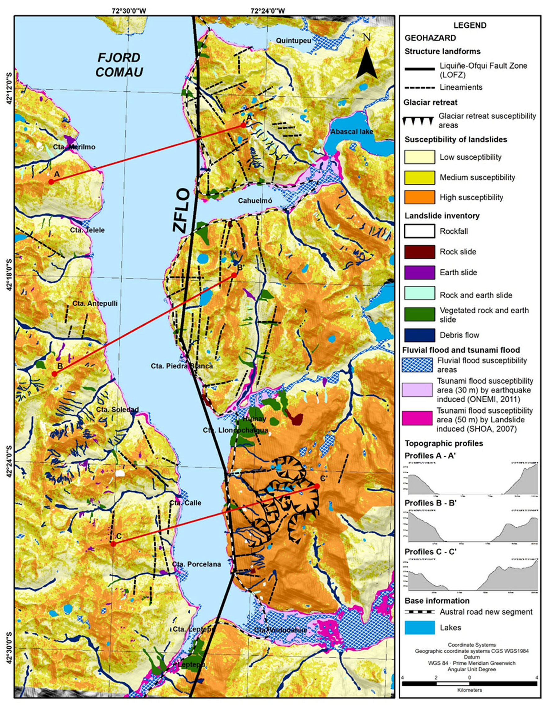
The landslide inventory (Figure 2) shows the distribution of different mass movements such as rockfalls, rockslides, earthslides, mixed rock and earthslides, and debris flows. Generally, a higher landslide density is documented on the eastern side of the fjord, due to the higher slope gradients (see profiles in Figure 2) and intrusive (mainly granites, granodiorites, tonalities, and diorites, 66%) as well as metamorphic (mainly schists and amphibolites, 26%) lithologies. The occurrence of debris flows and earthslides on the western side is characterized by volcanic rocks indicating a geologic control on landslide types.
The applied model was validated in the field through the geomorphological evidence of different mapped landslide types. A helicopter flight also allowed to map areas that are otherwise inaccessible due to the dense Patagonian forest and steep slopes.
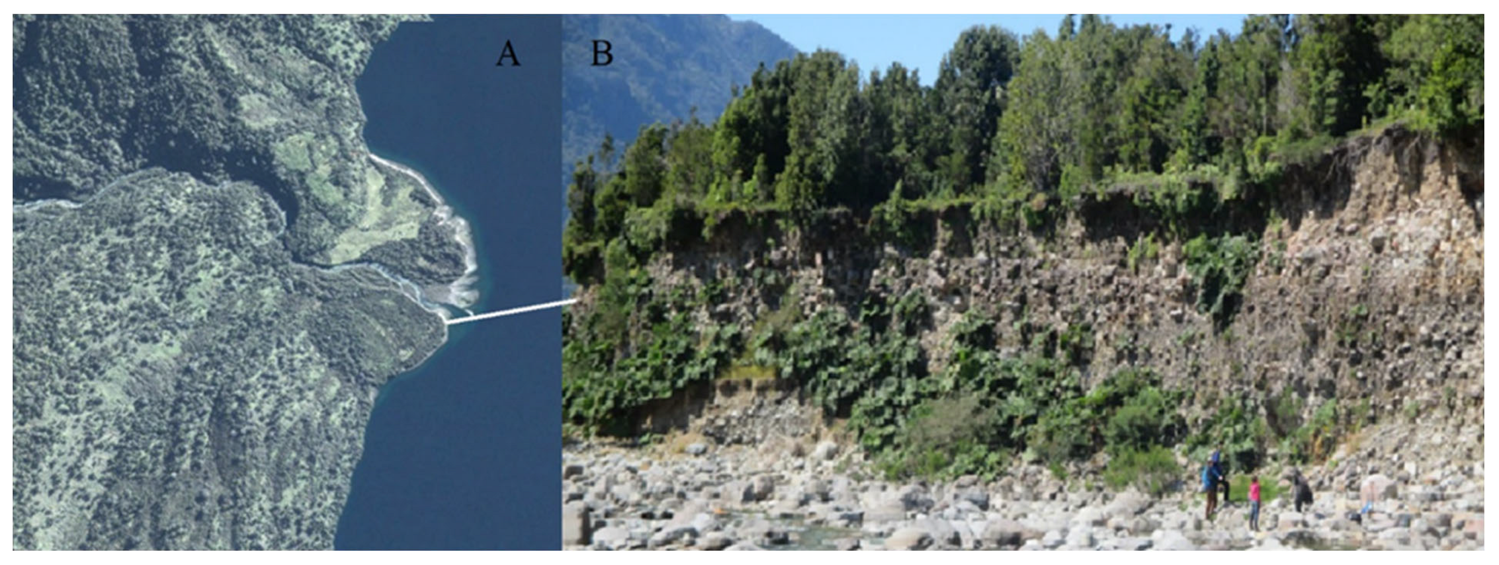
Debris flows are very common, especially in smaller catchments, draining to main fluvial valleys and/or the fjord developing alluvial fans and alluvial fan deltas. The valley alluvial fans are very dynamic and are activated by extreme rainfall events. It is possible to recognize these alluvial fans as Holocene geoforms, overlaying Pleistocene terraces, dated relatively using existing archeological evidence in Patagonia [46]. Larger fans draining into the fjord coincide with fluvial terraces levels and are linked to the Pleistocene time (Figure 3).
The evidence of historic landslides is registered during fieldwork through the recognition of vegetation growth patterns on slopes after landslides. There is historical evidence of landslides, such as the events of July 1957 and February 1980, both associated with extreme rainfall events (Figure 4).
In addition, the regional presence of the active Liquiñe-Ofqui Fault Zone (LOFZ) [30,47] makes the area prone to recurrent seismic activity, which in turn triggers exogenous processes such as mass movements. Earthquake-induced landslides on resistant rock slopes, which occurred in the Aysen Fjord during a shallow crustal earthquake related to the LOFZ in 2007 [34], showed the general capacity of earthquakes along the LOFZ to trigger large mass movements in the fjordland region.
Studies of this 2007 event [23,47] documented that the earthquake may trigger gravitational slope processes in any of the several local branches that constitute the LOFZ. Hence, mass movements seem to be the main hazard in the studied fjord environments. Further research is needed in order to fully assess the local seismic hazard in the region.

4.2. Flood and Tsunami Hazards

The areas affected by river floods were identified from the river geomorphology of the distal areas of the Andean basins of the Vodudahue and Huinay Rivers, through the identification of the river terraces, beds, and banks, showing evidence of past and current river action. This information was complemented with a flood susceptibility model [30].
At the mouths of these Andean basins, fan deltas evolved, as described for the northern hemisphere by [48,49]. They consist of fluvial gravel deposits, shaped like alluvial fans but with base levels reaching the sea, being subject to current fluvial and tidal operations [50]. These features have been considered as fluvial–tidal fan deltas of Holocene age (Figure 2 and Figure 5). They become completely flooded at every high tide.
The study area is affected by another significant latent hazard, namely, the local tsunamis, e.g., generated by large landslides. A documented example was registered in 2007 due to a LOFZ earthquake swarm in the Aysén Fjord. The main shock triggered large rockslides that in turn generated a local tsunami, causing human and economic loss in the salmon industry. Ref. [27] described the Aysén Fjord tsunami as associated with a 6.2 Mw shallow crustal earthquake, indicating that fjord environments are favorable to the occurrence of earthquake–landslide–tsunami sequences. Based on seismic-tectonic susceptibility [30] and recent seismic events linked to the LOFZ activity, the flooding areas of oceanic tsunamis due to interplate earthquakes and landslide tsunamis were considered. According to the data available from the Aysen Fjord tsunami in 2007, a height of 30 m.a.s.l. was indicated. This is the height of the safety area specified for Chile by the ONEMI (National Emergency Office). The modeled flood area for Aysén was also taken into account corresponding to an elevation of 50 m.a.s.l. Figure 2 shows that the areas susceptible to tsunami flooding are the river mouths and the alluvial fans. Both areas are also prone to river flooding.

4.3. Geohazard ‘Hotspots’ and Their Impacts

The ‘hotspots’ identified were obtained through overlapping the single geohazards as described above. In this study, we do not consider the order of magnitude of events or their frequency because it is beyond the scope of this study. However, the frequency of a natural hazard gives important information about the occurrence in a specific time interval, whereas the magnitude is related to the energy released by the specific event. Thus, earthquakes generally have high magnitudes and low frequencies but also trigger mass movements. The latter might also occur independently and be unrelated to earthquakes, thus, they generally have a higher frequency. Although the methods used in this study allowed an accurate identification and mapping of the spatial extent of single geohazards (and subsequent overlapping with other hazards), the analysis of magnitude–frequency relationships would have allowed an in-depth analysis of the return periods and the identification of potential thresholds for hazard occurrence.
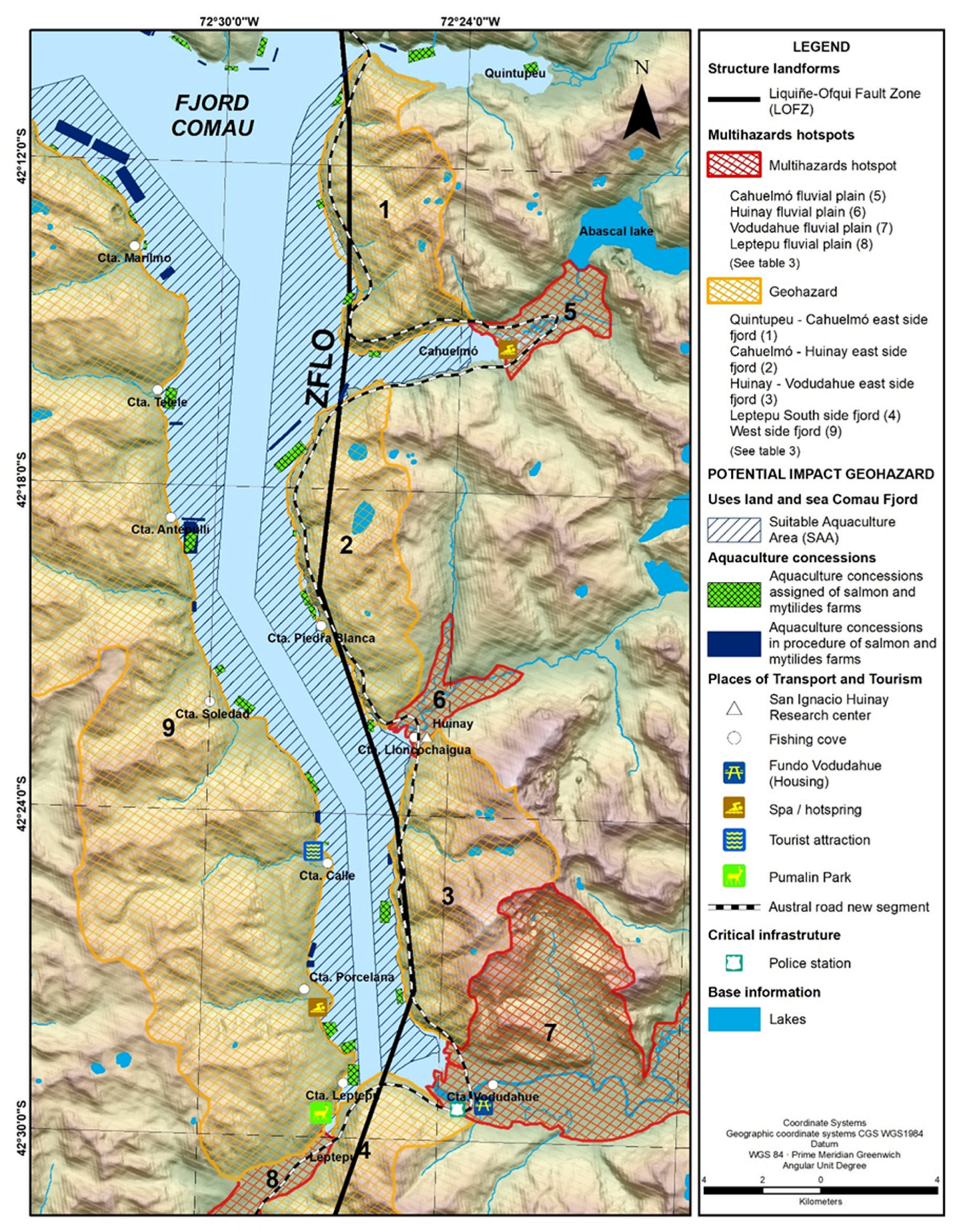
Our analysis is based on the hazards that were identified and mapped during fieldwork and by photointerpretation. Table 2 shows the ‘hotspots’ of dynamic processes and related geohazards that were taken into account. The ‘hotspots’ identified are directly related to the observed and modeled events. They represent the largest overlap of processes that might occur simultaneously and interdependently. The superposition of these processes finally indicates the spatial distribution of the geohazards. The area with the highest susceptibility to multi-hazards is the so-called Vodudahue fluvial plain (number 7, Figure 5). Figure 5 shows the ‘hotspots’ identified and subdivided into different zones: fjord side and alluvial plains.
Valley ‘hotspots’ are clearly distributed on the eastern slopes of the fjord (Figure 5), due to the evolution of the Andean valleys and fjords, also affected by the LOZF fault.
The lowest level of hazard means that there is low to medium susceptibility of tsunami and landslides. However, most of the study area shows a general susceptibility to natural hazards.
The planned Austral Highway is constructed on the eastern side of the fjord (Figure 2) and might be highly affected by geomorphological activities and related geohazards during the construction phase and when the highway is operational. In addition, current and future facilities linked to this national and international connection route are also at risk/vulnerable or will be at risk/vulnerable in future.
The identification of these ‘hotspots’ is related to the current land/water uses and future territorial planning of uninhabited areas with enormous potential for economic development due to the construction of the highway extension (Figure 5). Consequently, it is expected that the multi-hazard ‘hotspots’ on the one hand endanger and/or negatively impact the areas that would be otherwise favorable to economic activity and, on the other hand, contribute to the formation of risk areas.

4.4. Land and Sea Use in the Comau Fjord

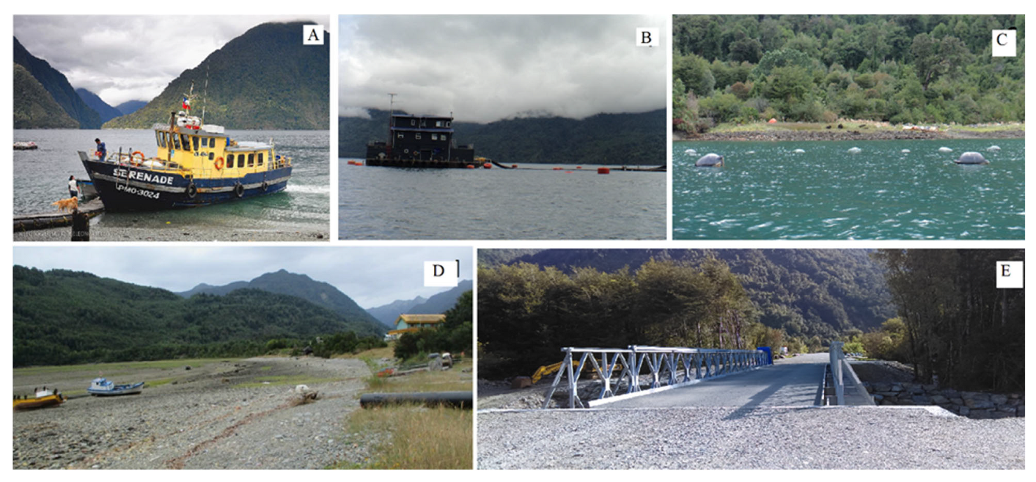
According to the collected fieldwork information, and complementary archival data from the National Fishery Service (SUBPESCA) and local administration (Puetro Montt), there are several fishers’ coves along the fjord, such as Huinay, Piedra Blanca, Leptepu, Porcelana, Soledad, and Calle, among others, located mainly at river mouths (Figure 2 and Figure 5). In each cove, up to three fishers work regularly and they have built temporary shelters. Two coves contain a small number of family houses: Vododahue and Leptepu. All these settlements lack road connectivity. They are only accessible by maritime transport (the Serenade boat) (Figure 6). The small number of permanent residents living along the coastline have their income from fishing activity that is oriented to family consumption and small-scale commercialization.
The area attracts tourism and related activities. The latter emerged in recent years and are centered on the presence of unique landscapes and natural attractions, such as hot springs and geysers connected to local volcanism. Tourism facilities are poorly developed due to the lack of direct road connectivity with the rest of the country. Therefore, currently just a few people visit these sites by taking one-day boat trips, or by camping in the area without access to electricity or any kind of sanitary system. However, during fieldwork (2016–2017), we noticed private investments linked to tourist accommodations (https://www.pampapartners.com/brochures/Vodudahue_esp.pdf accessed on 10 February 2022). In addition, the construction of the Austral Highway might foster further investment in tourism and hospitality in the next few decades.
A diverse infrastructure centered around aquaculture has been built throughout the fjord for seafood production (salmon, mussels, and trout). It is important to point out that the production of mussels requires far less space, infrastructure, and investment than salmon production. Most of the salmon farms, which are owned by large national and transnational companies, direct their production to external markets, whereas the mussel production is primarily for the national market [51,52]. Chilean law allows for delimiting the surface of the fjord and its waters, defining permitted and planned marine usage. Figure 5 shows the distribution of Suitable Aquaculture Areas (SAA) granted in the study area by the National Fishery Service (SUBPESCA).
These marine activities have drawn permanent workers from different parts of the region to the area. Salmon farm workers live in floating facilities and have work shift patterns of 15 consecutive days. Additionally, in Huinay, companies provide temporary housing and dining rooms for workers. Aquaculture also produces a constant flux of boat trips on the fjord, in order to bring in productive inputs and send out the marine production from the Aquaculture Apt Areas (AAA). The existing flow of workers and boats is economically important at the local level, because it promotes small informal commercial activity in Huinay, where fishers sell their products to independent salmon workers and aquaculture companies [17].
According to [53], aquaculture in the fjord will increase, due to the saturation of aquaculture concessions in other areas of Southern Chile (e.g., the western zone of the Chiloé Sea). In fact, the article 5 of the Chilean Fishing Law states that ‘fish farms which exist in the Los Lagos and Aysén Regions, may relocate within the same Region’. Thus, one of the expected scenarios once the construction of the Austral Highway close to Comau fjord has been completed would be the relocation of some of the aquaculture concessions to the study area, increasing the exposition of these types of productive activities and the risk.

5. Impact of Tsunami and Landslide Hazards

Regarding the impact on activities due to tsunami hazards (geoseismic- and landslide-induced), we found that 88% of the tourism activities might be impacted (Table 3, Figure 5) due to the fact that human activities are mainly located close to the coast line. The level of the tsunami flood hazard is high for transport, fishing, maritime infrastructure, and critical infrastructure sectors (e.g., the police station). The tsunami hazard situation represents an elevated risk scenario because almost all activities in the fjord would be affected, even in the case of a 30 m tsunami wave (geoseismic). In the case of the projected activities, the situation does not seem to be better. However, there is a lower risk level in terms of the planned Austral Highway that will be built at higher elevations than the tsunami exposure level. Nevertheless, the general risk level will remain very high for the entire area. It is important to note here that the inland location of the study site (140 km from the Pacific coastline) and the complex geography of the fiords in proximity of the study area may dissipate the energy of the waves generated by seismogenic tsunamis coming from the Pacific Ocean. Even though the effect of seismogenic tsunamis from the Pacific should not be discarded, we assume that this mechanism is less likely to have a major impact across the study site. Therefore, the focus of this research is associated with tsunamis generated by landslides or indirectly, associated with the seismic activity generated by the LOFZ, which can also generate a landslide–tsunami sequence, such as in the event of 2007. However, large-scale, high-resolution bathymetric explorations and numerical modeling are indeed needed to assess the run out of both sources of tsunamigenic events. Based on the 2007 event, we considered the areas under the 50 m.a.s.l. elevation as areas likely affected by landslide–tsunamigenic events (see Section 3).
In relation to landslide hazards, our research has identified two kinds of impact: (i) primary impacts that refer to the areas which would be directly affected by landslides (Figure 2) and (ii) secondary impacts refer to the areas which would be affected by a tsunami generated in turn by a landslide. Table 4 shows that, in general, the levels of potential impact due to landslides are less significant than those produced by tsunamis. In general, landslide impact levels are between medium and low. Thus, the fishers’ coves located on the river mouths would have low levels of risk, while the police station, a critical service, is located in a place with a medium level of exposure. The general situation of landslide hazards will become worse when taking into account the projected future use. In this scenario, the projected Austral Highway will be built in areas with medium (23.8%) and high (30.8%) susceptibility to landslide hazards, increasing the general risk to the road infrastructures and general transport in the area.
The construction of the Austral Highway will increase the connectivity of the fjord areas with the city of Puerto Montt and, therefore, to the global markets. Thus, the fjord could drastically change, becoming a center of economic attraction due to the enhanced connectivity. Considering the general trend in Chiloé, the territorial pattern in terms of an increase of aquaculture plots in the area can be predicted. However, it is a highly questionable densification with deep impacts on the territory and on the local economic development. However, the fact that there are already pending fish farm concession permit requests awaiting approval can serve as an indicator of a potential future increase in the number of concessions in the study area, particularly considering the economic benefits of fish farming during the last 3 decades and the environmental conditions of the area, which are favorable for this economic activity.
Considering all these dynamics, it is highly probable that the level of hazard and risk will increase significantly, especially in the case of tsunamis, because aquaculture activities and their infrastructures cannot be located outside the marine territory and the coastline. In addition, the tourism development related to the future route and better connectivity may also lead to an increased level of risk from both tsunamis and landslides. In any case, promoting the location of activities on sites with low levels of a landslide hazard and promoting strong, effective evacuation plans to deal with tsunamis are prerequisites for future development in the area. However, to mitigate the risk, early warning systems are already in use along the Chilean coast and are a very valuable technique to reduce at least the risk for human life (see: [54,55]).
Due to the potential/increased levels of hazard and risk, the need to review territorial planning practices is essential in the medium and long term, to ensure the sustainability of investments and the protection of both residents and visitors. It is vital to highlight the role of the state as well as of the national and regional authorities to establish national policies for public risk management [56,57].
It is therefore suggested that governance criteria and risk management should be taken into account for land-use planning practice. Moreover, integrated approaches should be promoted sustaining political solutions.

6. Conclusions

The Comau Fjord shows clear evidence of exposure to natural hazards, with significant levels of susceptibility to landslides and flooding due to oceanic tsunamis and to tsunamis produced by landslides.
The land and sea use of the Comau Fjord is mainly associated with aquaculture activity, along the entire coastline. Aquaculture is specifically dedicated to the cultivation of salmon and to a lesser extent of mussels. Despite the high potential for aquacultural farming, there is currently a lack of infrastructure and, hence, not many artisanal fishermen live and work there.
The flood hazards level is due to oceanic tsunamis and to tsunamis produced by landslides almost affecting 100% of the study area used for economic activities. Regarding the construction of the Austral Highway, it will be located in areas exposed to fluvial flood hazards. In the case of landslides, all infrastructure and economic activities are impacted to some extent by geohazards.
Generally, our assessment reveals a considerable level of exposure for the economic activities located in the study area. Moreover, we show that the impact levels are relatively high and homogeneous in the fjord. Thus, future risk studies in the area should consider that the level of risk will be differentiated and determined by the vulnerability level of the proposed economic activities.
In future, when the Austral Highway is operational, it is expected that the risk levels due to direct and indirect hazards will increase. In the fjord, through comparative cartography, a scenario of intensification of aquaculture was modeled, taking into account existing permits by the Fisheries Law showing an increase similar to that of Chiloé Island at present.
Likewise, the availability of territorial resources facilitates changes in land use. Private ventures with potentially high economic impact are currently in development.
Finally, it is important to stress the need to review present day land-use planning practices. Generally, the assessment of geohazards and related potential risks to infrastructure and population must be incorporated in planning procedures in order to guarantee sustainable land and sea use. It is essential to establish public policy mechanisms based on a comprehensive approach taking into account the magnitude and frequency of the hazards and risks identified.

Author Contributions

M.-V.S. conceptualized and designed this investigation. M.-V.S., J.A.-G., M.C., I.I., S.A.S. and M.M. performed the digital and field geomorphological mapping, alongside the geohazard identification and assessment. M.M.-B., M.C.-A. and G.G. conducted the assessment of the impacts on productive activities at the study site. M.C. and M.M. conducted geo-processing analysis using GIS techniques. All authors contributed to the interpretation and discussion of the results and wrote the manuscript. M.-V.S. coordinated the research activities and fieldwork. All authors have read and agreed to the published version of the manuscript.

Funding

This research was funded by Agencia Nacional de Investigación y Desarrollo of Chile (ANID) through the Regular FONDECYT project number 1151087, called ‘Recognizing the hotspot in the periglacial environment of the fjords and interior sea through the integrated evaluation of geohazard drivers, risks and impact on territory resources in the Gulf of Ancud: a methodological contribution’.

Data Availability Statement

Not applicable.

Acknowledgments

The authors would like to thank FONDECYT-ANID and ‘Centro de Investigaciones científicas San Ignacio del Huinay’ for their support in fieldwork activities.

Conflicts of Interest

The authors declare no conflict of interest.

References

  1. Goudie, A.S. (Ed.) Arid and Semi-Arid Geomorphology; Cambridge University Press: New Yok, NY, USA, 2013; ISBN 9780511794261. [Google Scholar]
  2. Neumann, B.; Vafeidis, A.T.; Zimmermann, J.; Nicholls, R.J. Future Coastal Population Growth and Exposure to Sea-Level Rise and Coastal Flooding—A Global Assessment. PLoS ONE 2015, 10, e0131375. [Google Scholar] [CrossRef] [PubMed] [Green Version]
  3. Sarmiento, J.P.; Hoberman, G.; Ilvecha, M.; Asgary, A.; Majano, A.M.; Poggione, S.; Duran, L.R. Private sector and disaster risk reduction: The cases of Bogotá, Miami, Kingston, San José, Santiago and Vancouver. Int. J. Disaster Risk Reduct. 2015, 14, 225–237. [Google Scholar] [CrossRef]
  4. Calil, J.; Reguero, B.G.; Zamora, A.R.; Losada, I.J.; Méndez, F.J. Comparative Coastal Risk Index (CCRI): A multidisciplinary risk index for Latin America and the Caribbean. PLoS ONE 2017, 12, e0187011. [Google Scholar] [CrossRef] [PubMed] [Green Version]
  5. Cardona, O. Environmental Management and Disaster Prevention: Two Related Topics—A Holistic Risk Assessment and Management Approach. Nat. Disaster Manag. 1999, 4, 151–153. [Google Scholar]
  6. Castro, C.P.; Ibarra, I.; Lukas, M.; Sarmiento, J.P. Disaster risk construction in the progressive consolidation of informal settlements: Iquique and Puerto Montt (Chile) case studied. Int. J. Disaster Risks Reduct. 2015, 13, 109–127. [Google Scholar] [CrossRef]
  7. Wisner, B.; Blaikie, P.M.; Blaikie, P.; Cannon, T.; Davis, I. At Risk, Natural Hazards People’s Vulnerability and Disaster; Routledge: London, UK, 2004. [Google Scholar]
  8. Alcamo, J.; Flörke, M.; Märker, M. Future long-term changes in global water resources driven by socio-economic and climatic changes. Hydrol. Sci. J. 2007, 52, 247–275. [Google Scholar] [CrossRef]
  9. Barton, J.R.; Irrarázabal, F. Adaptación al cambio climático y gestión de riesgos naturales: Buscando síntesis en la planificación urbana. Rev. Geogr. Norte Gd. 2016, 63, 87–110. [Google Scholar] [CrossRef] [Green Version]
  10. Bouwer, L.M. Have disaster losses increased due to anthropogenic climate change? Bull. Amer. Meteor. Soc. 2011, 92, 39–46. [Google Scholar] [CrossRef] [Green Version]
  11. Lei, Y. A preliminary discussion on the opportunities and challenges of linking climatic changes adaptation with risk reduction. Nat. Hazards 2014, 71, 1587–1597. [Google Scholar] [CrossRef]
  12. Märker, M.; Angeli, L.; Bottai, L.; Costantini, R.; Ferrari, L.; Innocenti, L.; Siciliano, G. Assessment of land degradation susceptibility by scenario analysis. A case study in Southern Tuscany, Italy. Geomorphology 2008, 3, 120–129. [Google Scholar] [CrossRef]
  13. Altieri, M.A.; Rojas, A. Ecological Impacts of Chile’s Neoliberal Policies, with Special Emphasis on Agroecosystems. Environ. Dev. Sustain. 1999, 1, 55–72. [Google Scholar] [CrossRef]
  14. Barton, J.R.; Fløysand, A. The political ecology of Chilean salmon aquaculture, 1982–2010: A trajectory from economic development to global sustainability. Glob. Environ. Chang. 2010, 20, 739–752. [Google Scholar] [CrossRef]
  15. Barton, J.R.; Román, A. Sustainable development? Salmon aquaculture and late modernity in the archipelago of Chiloé, Chile. Islan Stud. J. 2016, 11, 651–672. [Google Scholar] [CrossRef]
  16. Bustos, B. Brote del virus ISA: Crisis ambiental y capacidad de la institucionalidad ambiental para manejar el conflicto. Rev. EURE 2012, 38, 21–245. [Google Scholar] [CrossRef] [Green Version]
  17. Iizuka, M.; Kats, J. Globalisation, sustainability and the role of institutions: The case of the chilean salmon industry. Tijdschr. Econ. Soc. Geogr. 2015, 106, 140–153. [Google Scholar] [CrossRef]
  18. Wilcox, B.P.; Sorice, M.G.; Young, M.H. Dryland ecohydrology in the anthropocene: Taking stock of human–ecological interactions. Geogr. Compass 2011, 5, 112–127. [Google Scholar] [CrossRef]
  19. Beniston, M.; Stoffel, M.; Hill, M. Assessing Climate Impacts on the Quantity and Quality of Water (ACQWA); The EU/FP7 ACQWA Project Science and Policy Brief. A Large Integrating Project under EU R&D Framework Programme 7 (FP7); Université de Genéve: Geneva, Switzerland, 2013. [Google Scholar]
  20. Ilustre Municipalidad de Chaitén. Plan de Desarrollo Comunal de Chaitén, 2016–2019; Ilustre Municipalidad de Chaitén: Santiago, Chile, 2016. [Google Scholar]
  21. Ilustre Municipalidad de Hualaihué. Plan de Desarrollo Comunal de Hualaihué 2014–2017; Ilustre Municipalidad de Hualaihué: Santiago, Chile, 2014. [Google Scholar]
  22. Hervé, F.; Fuentes, F.; Calderón, M.; Fanning, M.; Quezada, P.; Pankhurst, R.; Rapela, C. Ultramafic rocks in the North Patagonian Andes: Is their emplacement associated with the Neogene tectonics of the Liquiñe-Ofqui Fault Zone. Andean Geol. 2017, 44, 1–16. [Google Scholar] [CrossRef] [Green Version]
  23. Vargas, G.; Rebolledo, S.; Sepúlveda, S.A.; Lahsen, A.; Thiele, R.; Townley, B.; Lara, M. Submarine earthquake rupture, active faulting and volcanism along the major Liquiñe-Ofqui Fault Zone and implications for seismic hazard assessment in the Patagonian Andes. Andean Geol. 2013, 40, 141–171. [Google Scholar] [CrossRef] [Green Version]
  24. Sarricolea, P.; Herrera-Ossandón, M.; Meseguer-Ruiz, Ó. Climatic regionalisation of continental Chile. J. Maps 2017, 13, 66–73. [Google Scholar] [CrossRef] [Green Version]
  25. Diaz, C. Análisis de Variaciones Areales de los Glaciares Ubicados en las Cuencas de Vodudahüe y Cahuelmó Durante el Período 1985–2017; Universidad de Chile: Santiago, Chile, 2018. [Google Scholar]
  26. Levi, B.; Aguilar, A.; Fuenzalida, R. Reconocimiento Geológico en las Provincias de Llanquihue y Chiloé; Instituto de Investigaciones Geológicas: Santiago, Chile, 1996. [Google Scholar]
  27. Sernageomin. Mapa Geológico de Chile: Versión Digital. Servicio Nacional de Geología y Minería, Carta Geológica de Chile, escala 1:1,000,000. Serie Geología Básica. 2003. Available online: https://www.sernageomin.cl/geologia/ (accessed on 10 October 2022).
  28. Sernageomin-BRGM. Carta Metalogénica X Región sur. Servicio Nacional de Geología y Minería–Bureau de Recherches Géologiques et Minières. Informe Registrado IR-95-05, 4Tomos. 2005. Available online: https://www.sernageomin.cl/geologia (accessed on 10 February 2022).
  29. Molina, C. Análisis de Susceptibilidad de Remociones en Masa en las Costas del Fiordo Comau, X Región, Chile; Universidad de Chile, Facultad de Ciencias Físicas y Matemáticas: Santiago, Chile, 2017. [Google Scholar]
  30. Soto, M.V.; Sarricolea, P.; Sepúlveda, S.A.; Cabello, M.; Ibarra, I.; Maerker, M. Geohazards in the North Patagonian Fjordland, Comau, Chile. In Sea Level Rise and Coastal Infrastructure; InTech, Open Science: London, UK, 2018; pp. 99–118. [Google Scholar] [CrossRef]
  31. Hungr, O.; Leroueil, S.; Picarelli, L. The Varnes classification of landslide types, an update. Landslides 2014, 11, 167–194. [Google Scholar] [CrossRef]
  32. Náquira, V. Susceptibilidad Remociones en Masa en las Costas de Fiordos Cercanos a Hornopirén; Universidad de Chile: Santiago, Chile, 2009. [Google Scholar]
  33. Sepúlveda, S.A.; Serey, A. Tsunamigenic, earthquake-triggered rock slope failures during the April 21, Aisén earthquake, southern Chile (45.5° S). Andean Geol. 2009, 36, 131–136. [Google Scholar] [CrossRef]
  34. Sepúlveda, S.A.; Serey, A.; Lara, M.; Pavez, A.; Rebolledo, S. Landslides induced by the April 2007 Aysén Fjord earthquake, Chilean Patagonia. Landslides 2010, 7, 483–492. [Google Scholar] [CrossRef]
  35. Van-Western, C.J. Use of Weights of Evidence Modelling for Landslide Susceptibility Mapping Lecture Notes; International Institute for Geoinformation Science and Earth Observation (ITC): Enschede, The Netherlands, 2003; pp. 1–21. [Google Scholar]
  36. Zevenbergen, L.W.; Thorne, C.R. Quantitative analysis of land surface topography. Earth Surf. Process. Landf. 1987, 12, 47–56. [Google Scholar] [CrossRef]
  37. Dahal, R.K.; Hasegawa, S.; Nonomura, A.; Yamanaka, M.; Masuda, T.; Nishino, K. GIS-based weights-of-evidence modelling of rainfall-induced landslides in small catchments for landslide susceptibility mapping. Environ. Geol. 2008, 54, 311–324. [Google Scholar] [CrossRef]
  38. Oppikofer, T.; Jaboyedoff, M.; Blikra, L.; Derron, M.H.; Metzger, R. Characterization and monitoring of the Åknes rockslide using terrestrial laser scanning. Nat. Hazards Earth Syst. Sci. 2009, 9, 1003–1019. [Google Scholar] [CrossRef] [Green Version]
  39. Bachofer, F.; Quénéhervé, G.; Hochschild, V.; Märker, M. Multisensoral Topsoil Mapping in the Semiarid Lake Manyara Region. Northern Tanzania. Remote Sens. 2015, 7, 9563–9586. [Google Scholar] [CrossRef] [Green Version]
  40. Scopesi, C.; Maerker, M.; Bachofer, F.; Rellini, I.; Firpo, M. Assessment of flash floods in a small Mediterranean catchment using terrain analysis and remotely sensed data: A case study in the Torrente Teiro, Liguria, Italy. Z. Geomorphol. 2017, 61, 137–163. [Google Scholar] [CrossRef]
  41. Servicio Hidrológico y Oceanográfico de la Armada, Puerto Aysén-Puerto Chacabuco. Carta de Inundación por Tsunami Generado por Remociones en Masa. 2007. Available online: http://www.shoa.cl/servicios/citsu/pdf/citsu_aysen_low.pdf (accessed on 10 February 2022).
  42. Naranjo, J.A.; Arenas, M.; Clavero, J.; Muñoz, O. Mass movement-indiced tsunamis: Main effects during the Pataonian fjorland seismic crisis Aisén (45°25′ S), Chile. Andean Geol. 2009, 36, 137–145. [Google Scholar] [CrossRef] [Green Version]
  43. Petley, D. Landslide hazards. In Geomorphological Hazards and Disaster Prevention; Alcántara-Ayala, I., Goudie, A.S., Eds.; Cambridge University Press: Cambridge, UK, 2010; pp. 63–74. [Google Scholar]
  44. Hearn, G.J.; Griffiths, J.S. Landslide Hazard Mapping and Risk Assessment. In Land Surface Evaluation for Engineering Practice. Geological Society; Griffiths, J.S., Ed.; Engineering Group Special Publication: London, UK, 2001; Volume 18, pp. 43–52. [Google Scholar]
  45. Aubrecht, C.; Fuchs, S.; Neuhold, C. Spatio-temporal aspects and dimensions in integrated disaster risk management. Nat. Hazards 2013, 68, 1205–1216. [Google Scholar] [CrossRef]
  46. Reyes, O.; Méndez, C.; San Román, M.; Francois, J.P. Earthquakes and coastal archaeology: Assessing shoreline shifts on the southernmost Pacific coast (Chonos Archipelago 43°50′–46°50′ S, Chile, South America). Quat. Int. 2018, 463, 161–175. [Google Scholar] [CrossRef]
  47. Lange, D.; Cembrano, J.; Rietbrock, A.; Haberland, C.; Dahm, T.; Bataille, K. First seismic record for intra-arc strike-slip tectonics along the Liquiñe-Ofqui fault zone at the obliquely convergent plate margin of the southern Andes. Tectonophysics 2008, 455, 14–24. [Google Scholar] [CrossRef]
  48. Villalobos, A.; Easton, G.; Maksymowicz, A.; Ruiz, S.; Lastras, G.; De Pascale, G.P.; Agurto-Detzel, H. Active Faulting, Submarine Surface Rupture, and Seismic Migration Along the Liquiñe-Ofqui Fault System, Patagonian Andes. J. Geophys. Res. Solid Earth 2020, 125, e2020JB019946. [Google Scholar] [CrossRef]
  49. Blikra, L.H.; Longva, O.; Braathen, A.; Anda, E.; Dehls, J.F.; Stalsberg, K. Rock slope failures in Norwegian fjord areas: Examples, spatial distribution and temporal pattern. In Landslides from Massive Rock Slope Failure; Springer: Dordrecht, The Netherlands, 2006; Volume 49, pp. 475–496. [Google Scholar] [CrossRef]
  50. González, N. Análisis y Caracterización Temporo-Espacial de la Morfología Fan-Delta en la Localidad de Huinay, Fiordo Comau, Región de los Lagos; Universidad de Chile: Santiago, Chile, 2016. [Google Scholar]
  51. Fløysand, A.; Barton, J.R.; Román, A. La doble jerarquía del desarrollo económico y gobierno local en Chile: El caso de la salmonicultura y los municipios chilotes. Revista EURE 2010, 36, 123–148. [Google Scholar] [CrossRef]
  52. French-Davis, R. Reformas económicas en Chile (1973–2017). Neoliberalismo, crecimiento con equidad, inclusión. Taurus 2018, 598. [Google Scholar]
  53. Arratia, P. Análisis de la Vulnerabilidad y el Riesgo de las Actividades Económicas: Pesca, Acuicultura y Turismo, Frente a las Amenazas de Origen Natural en el Fiordo Comau, Región de los Lagos; Universidad de Chile: Santiago, Chile, 2017; Available online: https://repositorio.uchile.cl/handle/2250/144236 (accessed on 15 June 2017).
  54. Wang, Y.; Sakate, K.; Cienfuegos, R.; Quiroz, M.; Navarrete, P. Far-field tsunami data assimilation for the 2015 Illapel earthquake. Geophys. J. Int. 2019, 219, 514–521. [Google Scholar] [CrossRef]
  55. Wang, Y.; Tsushima, H.; Sakate, K.; Navarrete, P. Review on Recent Progress in Near-Field Tsunami Forecasting Using Offshore Tsunami Measurements: Source Inversion and Data Assimilation. Pure Appl. Geophys. 2021, 178, 5109–5128. [Google Scholar] [CrossRef]
  56. Nogueira, F.R.; Oliveira, V.E.; Canil, K. Regional public policy for risk management: The implementation process in the greater ABC region, São Paulo city metropolitan region. Ambiente Soc. 2014, 17, 177–194. [Google Scholar] [CrossRef] [Green Version]
  57. World Bank. Informe Sobre el Desarrollo Mundial—Riesgo y Oportunidad: La Administración del Riesgo Como Instrumento de Desarrollo—Panorama General: Risk and Opportunity—Managing Risk for Development; World Bank: Washington, DC, USA, 2013. [Google Scholar]
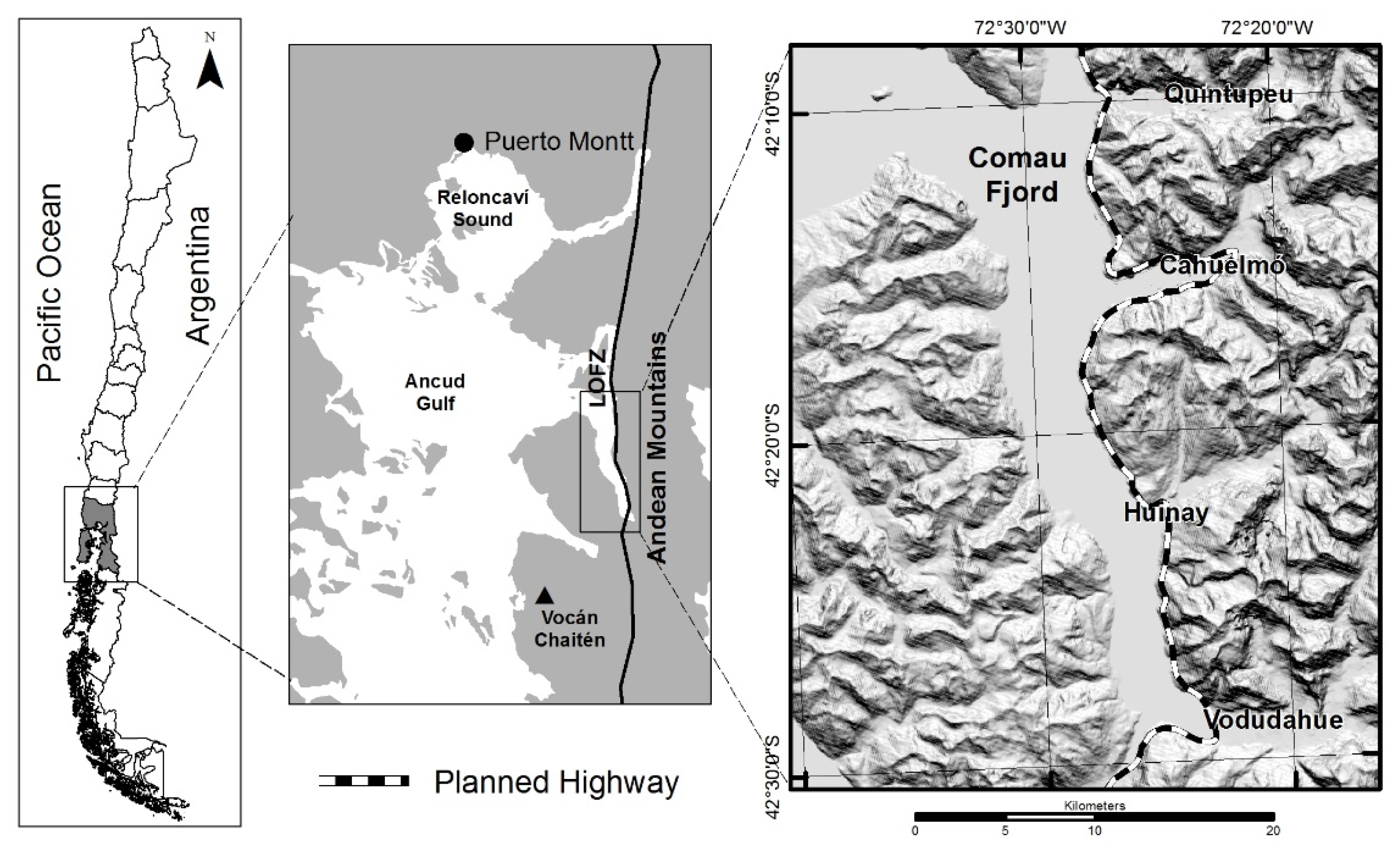
Figure 1. Study Area.
Geosciences 13 00209 g001
Figure 2. Map of natural hazards. (Modified after [34]).
Geosciences 13 00209 g002
Figure 3. (A) Porcelana alluvial fan. (B) Debris flow deposit in Porcelana alluvial fan (see Figure 2).
Geosciences 13 00209 g003
Figure 4. Evidence of landslides of 1957 (a) and 1980 (b), both on the east side of the fjord.
Geosciences 13 00209 g004
Figure 5. Map of multi-hazard ‘hotspots’ and their relationships with land and water use in Comau Fjord.
Geosciences 13 00209 g005
Figure 6. Aquaculture activity and settlements: (A) The Serenade boat, public maritime transport that connects Hornopirén and Leptetu and all the houses and villages in the sector between these two settlements. (B) Floating building used to house workers and store salmon crop supplies. (C) Cultivation of mussels. (D) Jetty, houses, and school in Huinay. (E) Bridge and road in Vodudahue.
Geosciences 13 00209 g006
Table 1. Input data for the landslide susceptibility modeling.
Conditioning FactorsDescriptionWeightRankPercentage (Weight)
Slope0–15°1low35% (0.35)
15–35°2medium
35–>55°3high
Parent material
(rock resistance)
1–25 MPa (soft rocks)1low20% (0.2)
25–100 MPa (hard rocks)2medium
100–>250 MPa (very hard rocks)3high
Distance to faults and lineamets>600 m1low15% (0.15)
>200 y < 600 m2medium
<200 m3high
Lineament density0–0.5 (m/km2)1low15% (0.15)
0.5–1.5 (m/km2)2medium
1.5–3 (m/km2)3high
Landslide inventoryAbsence1low15% (0.15)
Presence3high
Source: Proyecto FONDECYT N° 1151087.
Table 2. ‘hotspot’ assessment for multi-hazards.
GEOHAZARDS/‘HOTSPOT’S
LANDFORMS ZONE
(See Figure 5)
SUSCEPTIBILITY TO LANDSLIDESRIVER FLOOD SUSCEPTBILITY AREASOCEANIC TSUNAMI FLOOD SUSCEPTBILITY AREASLANDSLIDE TSUNAMI FLOOD SUSCEPTBILITY AREASGLACIAL RETREATTOTAL
GEOHAZARDS
MULTIHAZARDS OVERLAP ‘HOTSPOT’
(1) Quintupeu—Cahuelmó east side of fjordX--X-2-
(2) Cahuelmó—Huinay east side of fjordX--X-2-
(3) Huinay—Vodudahue east side fjordX--X-2-
(4) Leptepu—south side of fjordX--X-2-
(5) Cahuelmó fluvial plainXXXX-4X
(6) Huinay fluvial plainXXXX-4X
(7) Vodudahue fluvial plainXXXXX5X
(8) Leptepu fluvial plainXXXX-4X
(9) West side of fjordX--X-2-
Table 3. Potential impacts on elements at risk of flooding due to oceanic tsunami.
Activity/Land UseArea Potentially Affected by Floods Due to Oceanic Tsunamis Hazard at 30 m.a.s.l. (%)Area Potentially Affected by Floods Due to Oceanic Tsunami Hazard at 50 m.a.s.l. (%)
Existing Use
Tourism88%88%
Transport100%100%
Fishing100%100%
Maritime occupation100%100%
Police Station100%100%
Projected Use
Transport19%27%
Maritime occupation100%100%
Table 4. Potential impacts on elements at risk of flooding due to landslides.
Activity/Land UseDirectIndirect
Area Potentially Affected by LandslidesArea Potentially Affected by Landslide-Induced Tsunamis
HighMediumLowHighMediumLow
Existing Use
Tourism0%12.5%75%0%0%12.5%
Transport0%100%0%0%0%0%
Fishing0%0%100%0%0%0%
Maritime occupation0%0%0%35%65%0%
Police Station0%100%0%0%0%0%
Projected Use
Transport30.8%23.8%44%0%0%0%
Maritime occupation0%0%0%29%71%0%
Disclaimer/Publisher’s Note: The statements, opinions and data contained in all publications are solely those of the individual author(s) and contributor(s) and not of MDPI and/or the editor(s). MDPI and/or the editor(s) disclaim responsibility for any injury to people or property resulting from any ideas, methods, instructions or products referred to in the content.