Article

Geologically-Driven Migration of Landmines and Explosive Remnants of War—A Feature Focusing on the Western Balkans

1
Department of Hydromechanics and Hydraulic Engineering, University of the Bundeswehr Munich, Werner-Heisenberg Weg 39, 85577 Neubiberg, Germany
2
RISK Research Center, University of the Bundeswehr Munich, Werner-Heisenberg Weg 39, 85577 Neubiberg, Germany
3
Faculty of Civil Engineering, University of Sarajevo, Patriotske lige 30, 71000 Sarajevo, Bosnia and Herzegovina
4
Faculty of Civil Engineering, University of Belgrade, Bulevar Kralja Aleksandra 73, 11000 Belgrade, Serbia
5
Department of Hydraulic Engineering and Water Management, DHBW Mosbach, Neckarburkener Straße 8, 74821 Mosbach, Germany
*
Author to whom correspondence should be addressed.
Geosciences 2023, 13(6), 178; https://doi.org/10.3390/geosciences13060178
Submission received: 26 March 2023 / Revised: 6 June 2023 / Accepted: 10 June 2023 / Published: 14 June 2023
(This article belongs to the Section Natural Hazards)

Abstract

:
Landmines and explosive remnants of war are still present in the Western Balkans and remain a deadly legacy of the hostilities at the end of the 20th century. Over the years, several incidents have occurred in Bosnia and Herzegovina, in Serbia, and in Croatia where intact ordnance has caused injuries and fatalities. Floods, torrential flows, and gravitational mass movements pose a particular threat. Landmines and explosive remnants of war are mobilized and displaced into previously uncontaminated areas. We first discuss the historical and technical background of this hazardous situation. We then show which hydro-morphological processes are responsible for the mobilization and displacement. We then illustrate how a prediction of the likely contaminated areas can be obtained. We show that the problem can only be tackled using a stochastic-deterministic model. However, for the eventual development of risk-hazard maps, preliminary work using laboratory experiments and field surveys is required. The article, therefore, proposes a novel approach to the problem in an international research project. The aim would be to produce risk-hazard maps that can be used by elected decision-makers, administrative authorities, and emergency personnel in affected municipalities.

1. Introduction

A landmine is an explosive device that is hidden under or disguised on the ground with the purpose to incapacitate or eliminate enemy targets. Anti-personnel mines are designed to injure or kill enemy combatants. Anti-vehicle mines are designed to destroy vehicles and their occupants or to prevent them from continuing on their course. According to Article 2(2) of the Ottawa Convention [1], landmines are ordnance designed to be placed under, on, or near the ground or other surface, and to be detonated by the presence, proximity, or contact of a person or vehicle. When the enemy encounters a mine barrier, he must bypass it or clear it. This hinders or limits his progress.
From a military point of view, landmines were originally designed for defensive purposes. They were designed to create barriers that enemy forces could not cross. They can be used to protect key strategic locations such as front lines, borders, indispensable positions, and important bridges, or to block the enemy’s access to valuable territory or resources. Mines have regularly been planted individually or as mine barriers along rivers and mountain ranges, usually because they form natural topographical obstacles or have a particularly prominent military strategic value. Mines are also used to protect urban areas and key infrastructure. As a result, most minefields today are still located around natural boundaries such as rivers, streams, and mountains, or around relevant urban areas or infrastructure. This exposes them to environmental influences and associated variations in geological, hydrological, and morphological processes. Since rivers, streams, and mountain slopes are morphodynamically very active, the likelihood of landmines or other explosive materials being displaced by geomorphological processes is high.
The contamination of land by landmines is a serious consequence of wars, battles, and regional conflicts. Severely mined countries are Afghanistan, Angola, Cambodia, Croatia, Bosnia and Herzegovina, Serbia, Croatia, Mozambique, El Salvador, Iraqi Kurdistan, Kuwait, Libya, Nicaragua, Somalia, and Vietnam [2]. Besides landmines, so-called explosive remnants of war (ERWs) can litter former battlefields and regions of military conflicts. Explosive remnants of war refer to munitions that contain explosive materials and are left behind in the aftermath of a conflict. These can consist of unexploded artillery shells, grenades, mortars, rockets, air-dropped bombs, and cluster munitions [3]. In general, explosive remnants of war include three kinds of explosive munitions: (1) unexploded ordnance (UXO), as munition that fail to detonate; (2) abandoned explosive ordnance (AXO), as explosive weapons that have not been detonated during an armed conflict and have subsequently been abandoned, leaving them outside of the control of the party that initially left them behind; (3) improvised explosive devices (IED), as devices that are constructed and deployed in a non-standard way, typically using locally available materials, and often used as a tactic by non-state actors and insurgents in asymmetrical warfare.
The hostilities in the Western Balkans at the end of the 20th century are a tragic prime case for the remaining contamination of the land with landmines and explosive remnants of war up to the present day. From 1991 to 2001, the Yugoslav Wars occurred in former Yugoslavia and were related to its breakup. During the conflict, all the warring factions planted landmines close to the borders of today’s political entities. Additionally, unused and buried firearms, ammunition, and grenades also pose major threats. In addition, NATO executed an aerial bombing campaign known as Operation Allied Force against the Federal Republic of Yugoslavia during the Kosovo War. This campaign began on 24 March 1999 and ended on 10 June 1999, when Yugoslav armed forces withdrew from Kosovo and the United Nations Interim Administration Mission in Kosovo was established as a UN peacekeeping mission. The air strikes persisted until an accord was achieved. Consequently, unexploded bombs and rockets deployed during the NATO interventions are also present on land, in waterways, and in their surroundings. In general, landmines and ERWs continue to affect daily life in the Western Balkans. As a result, the countries of the Western Balkan region face one of the most serious landmine problems in the world. The clearance of landmines and ERWs, in general, is extremely challenging, dangerous, and usually a financial burden for the responsible authorities.
The purpose of this article is to introduce other serious consequences of landmines and ERWs beyond their lethal effects in military operations. The authors aim to highlight the major unpredictable threat of the undetected migration of landmines and ERWs due to flooding and gravitational mass movement. As the Western Balkans are currently experiencing an increase in extreme flooding and landslide events and the effects of climate change may increase the likelihood of explosives being washed away, the article has a clear focus on the Western Balkans. The article outlines a possible approach to modeling the mobilization and migration of landmines. This allows for the identification of newly contaminated areas downstream.
In this article, we first describe the study area and summarize the relevant background facts in Section 2. In Section 3, we explain the physical processes that generate the hazards. Section 4 contains the description of the scientific gaps and research challenges in explaining the processes at work. Moreover, we present a method for predicting the possible migration of landmines and ERWs. We point out that possible solutions will consist of collaborative laboratory experiments, field surveys, and hydro-morphological simulations. Finally, we describe that tracking a single ordnance during a flood event or landslide cannot address the challenges. Instead, we propose the application of a statistical model to estimate potential hazard areas following a fluvial event. We discuss the resulting opportunities in Section 5 and identify the associated requirements and preconditions.

2. Materials and Methods

2.1. Study Area from Geological Perspective

Southeast European states Albania, Bosnia and Herzegovina, Croatia, Montenegro, Kosovo, North Macedonia, and Serbia constitute the region known as the Western Balkans. The region is characterized by a wide variety of geological features and landscapes that were shaped by climate, tectonics, and other natural phenomena. The Western Balkans are located close to the boundary of the Eurasian and African tectonic plates, which dynamics led to the formation of a number of geological features, such as the Hellenic (Aegean) arc in the south and the Pannonian Basin in the north. Due to the Western Balkans’ location at the intersection of several tectonic plates, the region exhibits somewhat high intensity of geodynamic processes. It is a part of the wider Mediterranean region, one of the most seismically active regions in the world [4,5,6].
The northern portion of the Western Balkans is a part of the larger Pannonian Basin and includes parts of Bosnia and Herzegovina, Croatia, Serbia, and Slovenia. The main part of the region is characterized by steep, rocky terrain, and a deep valley region. This characteristic leads to very rapid surface runoff in the steep terrain and thus surface erosion and landslides occurring in the course of pluvial events [7]. Furthermore, runoff from the surrounding slopes accumulates in the steep valley, where water bodies are prone to flood events [8].
The region is a part of the Dinaric Alps, a mountain range that stretches from Slovenia to Albania. The limestone and dolomite make up most of the Dinaric Alps, which have experienced a vast water erosion and formed a karst topography (characterized by caverns, sinkholes, and underground river systems) in the past. The southwest portion is a thin strip of shoreline of the Adriatic Sea.
In general, the terrain of Western Balkans is characterized by a complex geological structure that includes different stratigraphic units from the Paleozoic to the Quaternary. The complexity is further increased due to various lithological types of sedimentary, metamorphic, and igneous rocks, mainly characterized by different degrees of weathering. Due to their different and variable physical and mechanical characteristics, these different rock massifs are subject to weathering and formation of clayey and gravely clay covers. Areas with deeper soil layers are potential areas for geodynamic processes and phenomena, including landslides. From a geological point of view, many landslides (particularly in Bosnia and Herzegovina [9]) involve only the surface layers of the soil (covers). Complete soil failure and mass sliding involving rocks and weathered rocks below the surface soil layer are rare. In surface layers consisting of materials such as sandy clay and generally fine-grained soil with larger pieces of stone fragments, hydrostatic pressure (and consequently, a decrease in shear resistance) often occurs. These factors contribute to the formation of shallow landslides and mudflows.

2.2. Study Area against the Background of the Hostilities at the End of the 20th Century

The 1991–1995 hostilities in the Western Balkans had many negative consequences for communities in the region, particularly within Bosnia and Herzegovina (B&H). Some two million landmines and ERWs are suspected of still littering the ground. With 956 km² of suspected area, B&H is currently the most mine-contaminated country in Europe and has remained so for many years, even 25 years after the end of hostilities (Figure 1) [10]. Since 1996, mine clearance operations have significantly reduced the total suspected area. According to the Bosnia and Herzegovina Mine Action Centre (BHMAC) [11], the cleared area amounted to about 228,157 km² until 2020. However, the remaining landmines are still highly concentrated in some areas, as shown in minefield maps [12].
Unfortunately, there have been many accidents during demining operations [11]; to date, 133 deminers have been injured, with a total of 53 fatalities. In addition, since 1995, 1767 people have been injured, 618 of them fatally. Most recently, three mine accidents were reported in B&H in 2021, resulting in three fatalities and one injury. More than 20 years after the start of the mine action, the suspected mine area in B&H in 2019 was estimated to be around 2% of the total area of the country.
The remaining landmines and ERWs directly affect the security of more than 500,000 inhabitants, about 15% of the total population of B&H. As might be expected, the dangerous areas are mainly along the border between the Federation of Bosnia and Herzegovina (FB&H) and the Republic of Srpska (RS), reflecting the outcome of four years of hostilities. Figure 1 shows the area suspected to be most contaminated with landmines in 2008, after 13 years of survey and clearance. It has been assumed by the inhabitants that a certain number of mines from B&H entered Croatia and Serbia via the Sava, Danube, and Bosna rivers. However, this problem is minor compared to the number of mines in B&H [13].
Although minefields played a limited strategic role in Croatia during the War of Independence, some 1.5–2.0 million landmines were deployed during the hostilities. In most cases, the location and pattern of minefields had not been recorded [15]. Post-war demining programs were coordinated by government agencies (e.g., the Croatian Mine Action Centre) to mark and clear contaminated areas. In 2007, the area still containing or suspected to contain mines was approximately 1000 square kilometres [16]. Bajic [17] reports an area of 887.7 km² suspected of containing landmines and ERWs in 2010. Besides the thousands of casualties, the Croatian Ministry of Reconstruction has reported that the agricultural industry in Croatia has suffered an annual net loss of USD 230 million due to landmines rendering land unusable for cultivation. In addition, the presence of landmines has led to estimated annual losses of USD 70 million for the logging and tourism industries in Croatia [2].
Hazards from remaining minefields and ERWs also pose a serious threat in Serbia (Figure 1). In addition to anti-personnel mines, anti-tank mines have also been laid in so-called mixed minefields covering an area of around 6 km². The danger comes not only from the past hostilities of the opposing forces of former Yugoslavia but also from the intervention of NATO forces. According to the Mine Action Centre of the Republic of Serbia [13], NATO forces dropped cluster bombs in 16 municipalities during the 1999 bombing campaign, while other types of aerial bombs can be found in about 150 locations in the Republic of Serbia (excluding Kosovo and Metohija). Although the Serbian army and police began clearing unexploded cluster munitions from the surface during and immediately after the bombing, some cluster munitions penetrated the ground and could not be easily detected and destroyed. As a result, it is estimated that some 750,000 m² of the territory of the Republic of Serbia is still contaminated with cluster munitions, representing approximately 15% of the total area affected by this type of ordnance [13].
Explosive remnants of war can also be found in inland waterways because of the 1999 bombing of Serbia. According to the Mine Action Centre of the Republic of Serbia [13], unexploded ordnance can be found in the Sava River and the Danube River. In the Sava River (near the Serbian–Croatian border, around the village of Jamena), improvised mines from the 1991–1995 conflicts are believed to still be present. In addition, a 2006 survey found 23 sunken German military vessels from World War II in the Danube River (the Iron Gate, near Prahovo, which sank in 1944) [13]. These vessels contain a large number of ERWs and naval mines. These ordnance not only pose a major threat to people and the environment in general but also significantly complicate the use of the Danube.
Another possible source of ERWs is accidents in military depots and ammunition production facilities. Several of such events have occurred in Serbia, in the vicinity of Paraćin, Kraljevo, and Vranje. Consequently, various types of ERWs or their parts can still be found around military sites in an area of about 13.5 km² [13].

2.3. Methods

The Western Balkan region combines the two serious problems described above. On the one hand, it is a seismically active region that is also prone to erosive surface runoff, landslides, and floods due to the characteristics of the terrain and rainfall events. On the other hand, it is precisely in the areas affected by these geomorphological processes that large quantities of landmines and ERWs were scattered, intentionally placed, or abandoned during the hostilities at the end of the 20th century. Although the majority of former minefields are now well-known, marked, or even documented on mine maps, geomorphological processes (landslides, debris flows, floods) in the Western Balkan region can cause the migration of individual ordnance or larger clusters of mines. This creates a serious risk that the former legacies of conflict will migrate to undocumented and unknown areas and become a deadly threat once again.
In the following section, we describe such scenarios that have already been observed in the Western Balkan region. The first step is an inventory of the types of hazardous ordnance that are present in the study area and their use during the conflicts in the Western Balkans. The fact that landmines and ERWs are mobilized and washed away by floods and landslides means that previously uncontaminated areas may become contaminated. The problem therefore needs to be addressed from the perspective of both military ordnance and hydromorphological processes. Describing the relevant processes and solving the major problem of unknown migration of landmines and ERWs requires a multidisciplinary approach. In Section 4, the authors therefore present a rigorous research path to predict or back-calculate the migration of landmines and ERWs.
Laboratory experiments are a promising way to study the mobilization and migration of ordnance in relation to different hydromorphological properties (e.g., flow velocity, flow depth, grain size, slope) under well-controlled conditions. However, in order to reflect the geological situation in the Western Balkans as accurately as possible, especially for pilot sites, field investigations should provide insight into the hydromorphological and geological situation. These results will then serve as input parameters for the laboratory experiments. Computational models can then be used to simulate the relevant processes on a larger scale. Where appropriate, the results of the laboratory experiments can be used to calibrate and validate the computational model. However, in order to predict the mobilization and dispersion of landmines and ERWs, the computational model must be combined with a stochastic-deterministic model, since a single ordnance cannot be tracked in ordinary flow models. It is likely that this combination of methods will be the key to success.
Therefore, a first research hypothesis is that the mobilization and advection of landmines and ERWs due to floods or landslides can be studied experimentally and numerically. A second research hypothesis is that a calibrated and validated stochastic-deterministic model can be used to predict and estimate potential migration of risk-prone areas. This in turn would be extremely valuable information for the affected areas.

3. Hazards Posed by the Unnoticed Migration of Landmines and ERWs

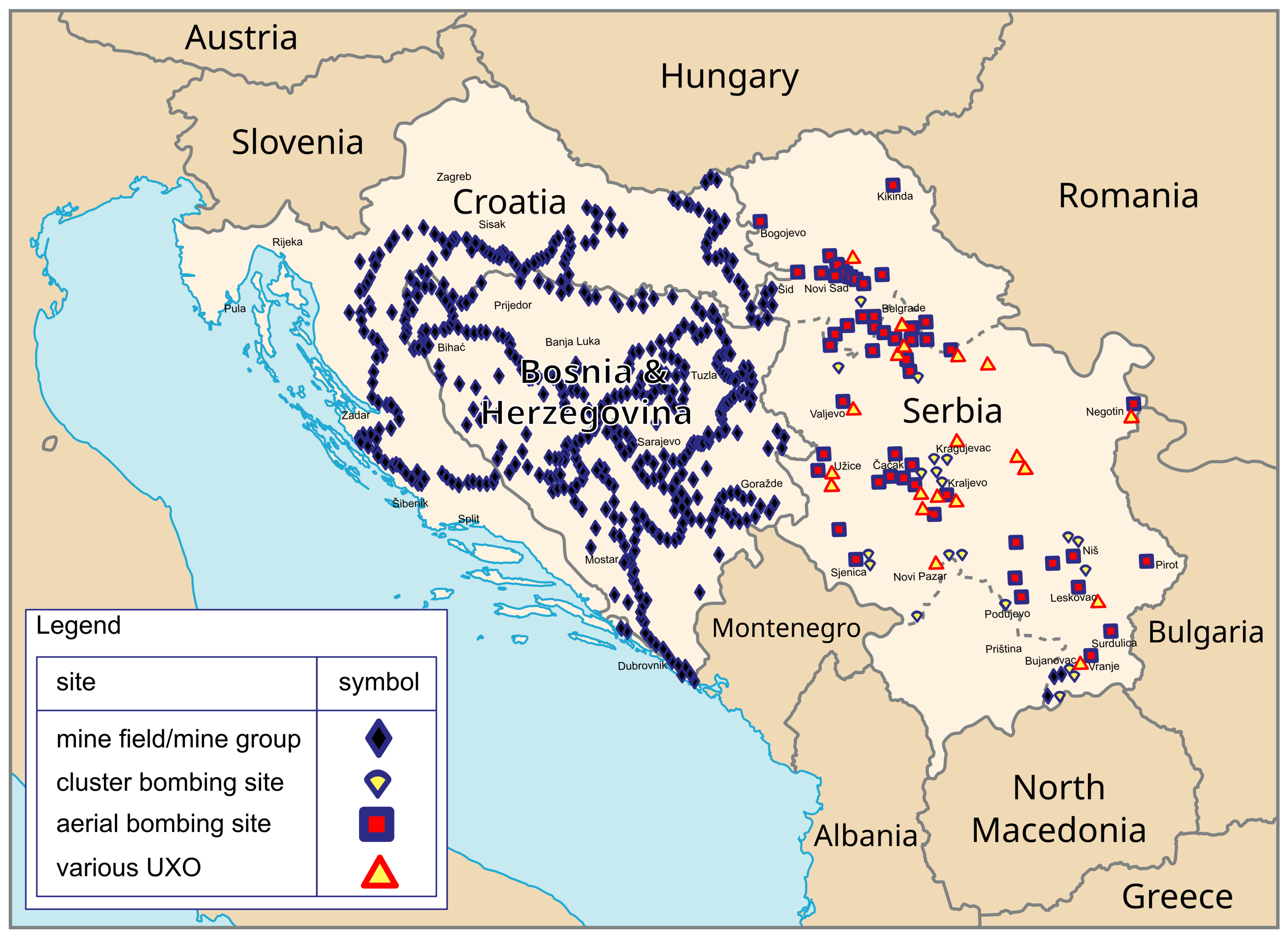
3.1. Usage of Landmines during the Western Balkan Hostilities

Landmines, and anti-personnel landmines in particular, were generally perceived without significant negative judgment prior to the 1990s. They did not receive undue attention as a distinct group of “problematic weapons”. Rather, they have been regarded as conventional weapons, and as common and potentially unavoidable tools used by armed forces around the world, similar to firearms and artillery shells [18]. Landmines were also used throughout the Western Balkan hostilities to protect military barracks and other facilities in both rural and urban areas. Common mines include PROM-1 bounding mines (Figure 2a) and MRUD directional anti-personnel mines (Figure 2b), as well as much smaller and lighter mines, some of which contain a high proportion of plastic. When triggered, bounding mines such as the PROM-1 are launched into the air and detonate approximately 1 m above the ground. They spread shrapnel in all directions. Directional anti-personnel mines (such as the MRUD) are designed to kill or injure by fragmentation. The PMA-2 anti-personnel mine (Figure 2c) has the shape and size of a can of shoe polish and contains 100 g of TNT. The mine is triggered by the pressure of more than 5 kg on the star-shaped pressure piece. The PMA-3 mine (Figure 2d), which is 40 mm high and 111 mm wide, consists of two plastic shells held together by a black rubber skin. A mass of approximately 8 kg is required on the upper shell to trigger the 35 g of Tetryl explosive. It is said that this plastic mine is extremely durable and waterproof. In particular, the PMA-3 plastic mine is said to remain operational even after being submerged for a long time.
Unfortunately, there is sparse documentation of the minefields laid until the beginning of 1992. At present, approximately 98.6% of suspected minefields are in forests. The remaining area is mainly on agricultural land [19]. Existing landmines have a negative social and economic impact and pose a general threat to the population living in their vicinity. In addition to the forestry and agricultural areas, suspected minefields can impede access to essential infrastructure. For example, if drainage canals cannot be maintained because of suspected mines, they can be the cause of intermittent flooding. Similar challenges exist along waterways on the banks of the Drava, Kupa, and Sava rivers, where mines were laid during hostilities.

3.2. Migration of Landmines and ERWs Induced by Floods

Floods are natural phenomena that usually affect areas close to the actual stream or waterway. However, the flow velocities on the floodplain can also cause the soil to be floated, then mobilized, and finally eroded. Objects in the soil, such as large stones, roots, and even landmines or explosive remnants of war can be unearthed and carried away. Deposition occurs in areas of becalmed flow or after the end of high water. The mine will then migrate to previously uncontaminated areas as reported by [20,21,22]. As a result, existing mine maps are no longer accurate. In addition, when urban areas are flooded, stockpiles of weapons and ammunition may be washed away, as for example reported for the Samac flood in 2014 [23].
The mobilization and migration of landmines and ERWs due to flooding has been observed in the past during various flood events around the world. In 1998, the border regions of Nicaragua, Honduras, Costa Rica, and Guatemala still contained some 83,000 landmines left over from the civil wars of the 1980s and early 1990s. Hurricane Mitch caused heavy rains in Central America in October and November 1998, resulting in a flood-induced displacement of an unknown number of landmines. In Nicaragua and Honduras, the mobilization of minefields caused at least three deaths and eight injuries [20].
In Mozambique, anti-personnel landmines (remnants of the 1977–1990 civil war) were mobilized and displaced after heavy rains in 1999 and 2000. Fishermen are reported to have caught some mines up to 20 km downstream from contaminated areas [21].
In 2010, devastating floods caused a migration of landmines from the Kashmir region into Pakistan, particularly on the plains of Punjab. This event was not scientifically studied, so there are no reliable sources to reconstruct the extent of the mine migration. However, it has been widely reported in the international press [24].
Current challenges arise from Russia’s war against Ukraine, which began in 2022. Recent incidents have been reported from coastal locations such as Odessa, where civilians swimming in the sea have been killed by sea mines washed ashore. Tondo [25] reports that
[...] the Black Sea is littered with hundreds of mines dropped by both sides in Russia’s war on Ukraine, posing a serious threat to people and the reopening of grain shipping routes halted by Moscow’s naval blockade.
Other recent reports highlight that the threat from mines planted by Russian forces in Ukraine is widespread and will take years to clear [26].
In May 2014, Cyclone Tamara caused the worst flooding in the last 120 years in Bosnia and Herzegovina, Croatia, and Serbia. Flooding caused by heavy rains resulted in the mobilization and dispersal of mines in the numerous existing minefields. According to Bajic [27], the total flooded area in B&H alone was 831.4 km². Although the total amount of displaced mines was less than originally estimated, some areas previously considered mine-free had to be re-surveyed and partially cleared [28]. The mine expert Thomas Küchenmeiser (head of the German chapter of the International Campaign to Ban Landmines) told the German Foreign Broadcasting Deutsche Welle in an interview in 2014 [29] that he
[. . . ] can’t say, exactly, how many mines have been washed away to non-contaminated areas. But basically, it’s very dangerous because the public isn’t expecting them at all and isn’t prepared. They must immediately try to find out which municipalities could be affected, inform and warn the population there.
Küchenmeiser adds that people living along rivers and streams are particularly affected because
[. . . ] it has to do with mostly plastic mines, which are very light. These mines get washed many kilometers away.
As a result, the Mine Action Centres of the three affected countries have made efforts to address this additional threat. It has also provided valuable information on the movement of mines and their likely pathways.
Besides mines, the presence of unaccounted weapons and ammunition in the Western Balkans is an additional concern. Many civilians and former soldiers reportedly kept their arsenals of weapons and ammunition even after the fighting ended [30]. In addition to firearms, they also hid anti-tank weapons and hand grenades in their homes. According to Esad Aletic of the Bosnian Mine Action Centre, such ERWs were removed from households during floods, for example in the town of Samac in northern Bosnia. Similar incidents have been reported in Prijedor, Bijeljina, Brcko, Doboj, Gradacac, Gracanica, Kalesija, and Tuzla [30].
Although flood-induced mobilization and displacement of landmines and ERWs have been recognized as a global problem for many years, no research has been conducted on the mobilization and migration of such ordnance in general. Only Hagen [22] identified areas potentially at risk from flood-induced mine dispersion in so-called reverse-engineered flood hazard maps for Afghanistan. However, they mainly focus on identifying flood-prone areas in developing countries based on the limited data currently available. As Hagen [22] do not provide information on how they derived the areas at risk, it can be assumed that their approach is based on estimation.
In addition, according to the United Nations Development Programme, B&H is significantly exposed to the threat of climate change. However, the Western Balkan state has a limited capacity to address and adapt to the negative impacts of climate change. It is predicted that the frequency and severity of flooding from its major rivers will increase, ultimately leading to the easier mobilization of landmines [31]. Once mobilized, lightweight plastic mines can travel up to 14 kilometers from their original location, according to the Borgen Magazine [31].
The hydromechanical process of mobilization and transport or behavior of landmines and ERWs in a stream is not well-understood. It can be assumed that a buried mine in a floodplain (Figure 3, panel A) is subjected to bed shear stress during a flood event (Figure 3, panel B). From a macroscopic point of view, the bed substrate begins to mobilize when the bed shear stress exceeds a critical value, which depends on the properties of the fluid and the substrate, in particular the solid density and grain diameter.
In general, the interaction between the flowing water and the sediment layer can lead to a variety of processes. For example, landmines or ERWs may react by
  • remaining in its position;
  • facing scouring due to the removal of sediment in its vicinity, eventually relocating into the hydrodynamics-induced carved-out scour holes (Figure 3, panel C);
  • being mobilized and relocating along with the rolling, sliding, and jostling bedload transport on the traction carpet (Figure 3, panel D);
  • leaving the traction carpet due to increasing lift components of the fluid forces and bouncing along with the flow (saltation) (Figure 3, panel E);
  • being entrained and relocating as suspended load within the water column (Figure 3, panel F);
  • being buried by bedload material or suspended sediment during or after one of the above-mentioned processes (Figure 3, panel G).
Whether the transport of the ordnance initially starts with the bedload depends on the physical properties of the ordnance and its interaction with the bed substrate. One scenario is that although the grains are eroded by the bed shear stress, the fluid forces acting are not sufficient to mobilize the mine due to their larger diameter or higher density.
Once the mine is mobilized, the transport process could activate and trigger the ordnance (Figure 3, panel H). Although this has not been reported, it would neutralize the potential threat. In the other scenario, the ordnance reaches an area of lower flow velocities and shear stresses, so that it is deposited on the riverbed or bank and continues to be active. The ordnance could then be buried by bedload material or suspended sediment.
In summary, there are many ways in which a landmine or ERW can migrate in a river or flood. The process of mobilization, transport, detonation, or deposition depends on a number of factors. As the weight, shape, and possibly burial depth will vary between different product types, the previous use of the mine, the original locations, the type of ordnance, its geometric dimensions, and physical characteristics will play a crucial role. In addition, the surrounding soil conditions will have a significant impact on the mobilization and transport of the ordnance.

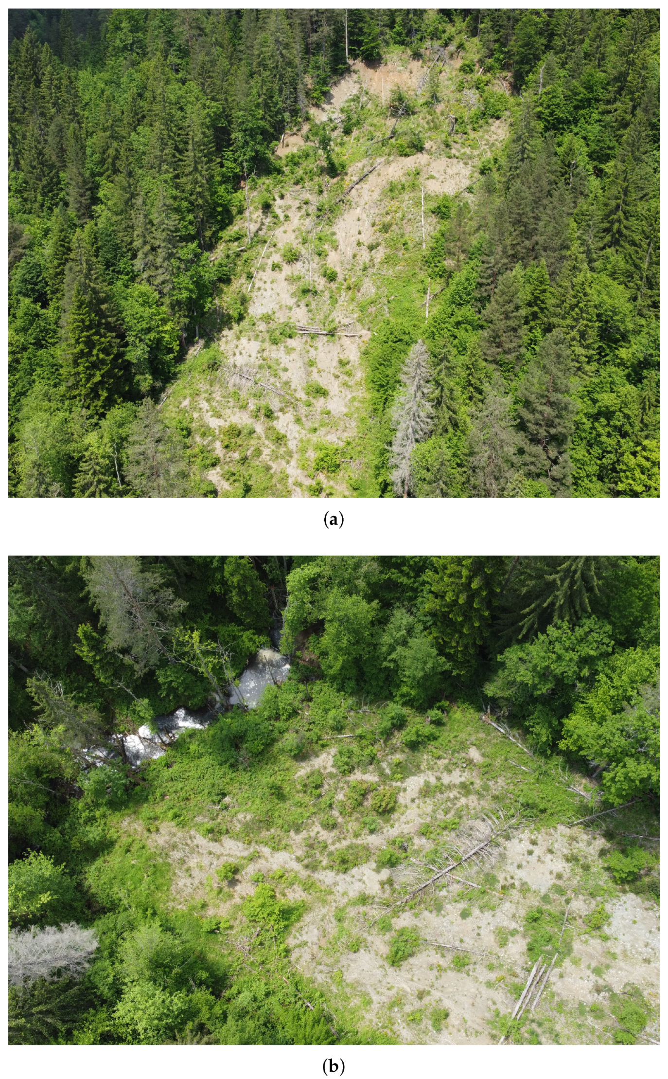
3.3. Migration of Landmines and ERW Induced by Gravitational Mass Movements

Landmines are also often used in mountainous areas. Additionally, explosive remnants of war (such as cluster munitions) have remained in many remote areas after hostilities. There have been cases from the Western Balkan floods of 2014 where landmines and ERWs migrated from their original deployment site together with gravitational mass movements such as landslides, debris flows, or torrential flows [32]. For example, heavy rainfall during Cyclone Tamara in May 2014 triggered landslides and debris flows throughout Bosnia and Herzegovina, Croatia, and Serbia. In several known existing minefields, numerous ordnance were mobilized and drifted with the sediment mass, directly affecting existing minefields in an area of approximately 37.48 km² [27]. Figure 4 shows a prime example of a landslide in a mine-contaminated area about 800 m north of the municipality of Olovo, near Sarajevo. Between 2013 and 2014, a 50 m wide slope section failed over a length of 150 m (Figure 4a). Most of the 5–10 m thick mass and several tree trunks entered the Grabovica Creek, which flows below the failure area (Figure 4b). It remains unknown whether landmines and ERWs entered the torrent. If so, it is highly likely that the ordnance subsequently migrated to the inhabited area of Olovo and entered the Krivaja River and then perhaps further into the Bosnia River, which finally enters the Sava River on the northern border of the country (border with Croatia).
Unlike mobilized ordnance in waterways, streams, or floodplains, where the grain size is often significantly smaller than the ordnance dimensions, the diameter of anti-personnel mines or small ERWs may be in the range of moving grains or boulders within the gravitational mass movement. Heavier ordnance, such as anti-tank mines, can be displaced easily by landslides, especially when the downward forces are amplified in steep terrain.
When soil movement is initiated during a landslide, the incorporated ordnance migrate in the gravitational mass movement. There is a good chance that the landmine or ERW will be buried after the event. Since grain movement within the body of the mass movement is also governed by the inertia ratio between the fluid phase and the grains, entrained ordnance may also experience buoyancy forces and eventually drift on the surface of the mass flow. In addition, since gravitational mass movements typically contain larger objects such as boulders or logs, and grain collisions are usually significant in such events [33,34], the collision may easily overcome the force necessary to trigger mines, especially anti-personnel mines with low required trigger pressure (e.g., the PMA types). If these mines do not detonate in such events (which has not been investigated yet), mine clearance, or at least marking of contaminated sections, is typically more challenging in such inaccessible, densely forested and steep areas. In such cases, clearance must be carried out by time-consuming and costly manual searches, as grinding wheels (mechanical demining) cannot move through the minefields in densely forested areas [29].
It is also possible that landmines and ERWs have entered streams that flow below the landslide failures. Ordnance can then move relatively easily with the fast and turbulent flow of the torrent. Eventually, they will be carried along the flow path of the torrent. Hazards then arise when the torrent passes through urban areas.

4. Scientific Gaps, Research Challenges, Possible Solutions

The migration of landmines and explosive remnants of war is a serious concern in areas contaminated by such ordnance during hostilities. It is therefore necessary to identify, mark, and eventually clear the actual presence of these ordnance. However, it is also important to consider where these ordnance may migrate when exposed to environmental forces. In this context, the effects of floods and gravitational mass movements should be considered.
From a macroscopic point of view, neither landmines nor ERWs will significantly alter the general morphological characteristics of the riverbed or a failing and sliding soil body. For example, a single ordnance will only have the effect of a mathematical outlier on the grading curve. Its dimensions will also not cause hydraulic resistance effects that would generally affect the basic morphological processes in the stream. Thus, macroscopically, a river with a mine, shell, rocket, or bomb on its bed will behave in the same way as an uncontaminated river. Predicting where the ordnance will migrate during a flood event cannot be answered by the generally accepted bedload transport formulae.
From a microscopic point of view, an individual landmine or ERW can be considered as a single object in a stream or bedload. However, their properties do not generally correspond to those of the surrounding natural sediments. In particular, the dimensions of such an ordnance in a river (except perhaps in torrents) are much larger than the diameter of representative grains. There are also differences in density and surface properties so that an ordnance is a “sedimentological alien particle” in a stream. On the other hand, it can be modeled with a Lagrangian approach, considering its trajectory and the hydro-morphological forces.

4.1. Experimental Investigations under Laboratory Conditions

While there is little research on how rivers’ mechanical processes effect deployed ordnance, it appears to be adequately covered for naval mines. Consideration has already been given to studying the migration of a single ordnance (microscopic view) for ground mines (type of naval mines). In contrast to landmines and ERWs on land, the circumstances are somewhat different. Ground mines are delivered to their destination and fall to the seabed, where they are fully exposed to ocean currents. Ground mines are known to be partially or completely buried by the morphodynamic effects of the seabed. As a result, several processes can act simultaneously. Firstly, the current can create a scour behind the mine in which the mine rolls and is subsequently partially or completely buried by bedload transport, ripples, or dunes. The layering of sinking suspended solids can also occur. These complex processes occur against a background of tidal influence with changing current velocities and directions, as well as gravity waves.
Several methods have been developed in the past to study the problem of buried ground mines. Some of these are empirical in nature and result from small-scale laboratory experiments. The main empirical models for the sedimentation of buried mines, which can be used as a starting point for further studies, are the following:
  • formulas for suspended sediment and bedload transport by Carstens [35] based on experiments for the settlement of cylindrical mines in the seabed as a result of gravity waves;
  • graphical wave scour model approach “Prediction of Mine Settlement in Sediment” [36];
  • empirical model “Wave-Induced Spread Sheet Prediction (WISSP)” [37];
  • “NBURY” model [37];
  • Defense Research Agency Mine Burial Environment (DRAMBUIE) model [37];
  • Vortex Lattice models for scour burial [37];
  • Mulhearn model for bedform burial [37];
  • Underwater Munition Expert System (UnMES) [38,39].
The response of a landmine or ERW when a flood erodes the material in the floodplain where the ordnance is located has not been observed or measured yet. This process should be studied under different flow conditions (water depth, flow velocity), sediment characteristics (grain size distribution, sediment layer height), and ordnance characteristics (type, burial depth). There are challenging research questions to be answered, such as: (1) How long does it take for the ordnance to erode? (2) When and how is the ordnance mobilized and what is the subsequent movement (tilting, rolling, sliding), and is it entrained and moving with the bedload? (3) Under what conditions is the ordnance incorporated into the water column? (4) How and when is the ordnance deposited? (5) Is the ordnance triggered during the process?
Since the mines commonly used (anti-personnel mines) are rather small, such investigations can be completed under laboratory conditions without downscaling, thus avoiding scaling effects. This requires replicas that are as close as possible to the real mines and ERWs, but without the danger of detonation. This might be challenging as the replicas must have equal properties, in particular with regard to dimension, shape, density, weight distribution, or surface friction. Importantly, the explosive material needs to be replaced with a harmless substitute without manipulating the ordnance’s properties.
A challenging point will be to compare the mobilization of the ordnance while measuring the acting flow effects, in particular the flow velocity in all three dimensions, and additionally to determine the turbulence. Especially under laboratory conditions, flow velocity and turbulence can be determined using either Acoustic Doppler Velocimetry probes, Particle Image Velocimetry, or Particle Tracking Velocimetry techniques. However, the mobilization will not be initiated suddenly but probably starting with scouring effects of the bedload around the ordnance followed by sliding and rolling of the ordnance, or (depending on the flow condition) by being lifted into water column. Thus, the experiments must be well-designed and the applied measurement technique so sophisticated that all possible mobilizations can be observed and determined accurately. In principle, the movement of the ordnance can be tracked by video recording and subsequently analyzed by image analysis techniques, such as those described in Baselt [40].
A promising way to track acceleration and motion of the ordnance in laboratory experiments is state-of-the-art equipment such as 3-axis gyroscopes in combination with 3-axis accelerometers and digital motion processors. These devices capture the acting accelerations, velocities, and rotations and track the three-dimensional trajectory. Such sensors are widely used in smartphones and have been intensively examined in grain tracers or smart stones to track grain replicas [41,42,43,44,45] (Figure 5). These techniques can simplify the process of obtaining information about the type of movement and whether the ordnance is either sliding, rolling, or being scooped out. If such equipped smart ordnance is moving, it is also possible to measure the impact force when the ordnance hits an object or is hit by, for example, a grain. This, in turn, can help to assess whether an ordnance could be detonated (reached the necessary pressure to cause an explosion) during a flood event. Nevertheless, experimentally challenging is usually the calibration of such devices. Furthermore, in situ data logging can be realized by a cable connection between the smart ordnance and a data logger or by using a storage device inside the smart ordnance. Although the first option allows live tracking of the physical variables, the connecting cable disturbs the flow and the ordnance mobility. Intrinsic data logging has the advantage of an undisturbed measurement but impedes live tracking.
However, field surveys can help to identify typical soil types/conditions and slope geometry in pilot areas. Data from field surveys are necessary and important for the construction, calibration, and verification of the physical conditions in the laboratory experiments. Insights from the data can help to understand the engineering geological conditions on the slopes of highly vulnerable areas close to rivers. In addition, insights into the gradation of the riverbed material will enable the construction of physical models. However, extensive field surveys, soil sampling, and analyzing is often time-consuming and expensive. It is therefore crucial to sample in advance those river basins where either flood events involving landmines and ERWs have already occurred or where they are likely to happen.

4.2. Computational Models

In combination with field survey data, the results of laboratory experiments can be used to develop and calibrate a computational Explosive Ordnance Model (EOM), which in turn can be used to predict the mobilization and dispersion of landmines and ERWs (as shown in Figure 6). The EOM must be coupled with a numerical flow model (e.g., TELEMAC-MASCARET [46], UNTRIM [47,48], MIKE+ [49]) that includes a bedload transport module or a multi-phase mass flow model (e.g., [50,51]). As a one-dimensional flow model does not provide sufficiently accurate simulation results and the computational effort for a three-dimensional model is too high for long river reaches, a two-dimensional depth-averaged flow model can be used. The EOM and the flow model should be one-way-coupled, as the transport of the ordnance is not expected to affect the flow. For model generation, the usual input data for the flow model include a digital terrain model, land use, and structures. Additional information on the discharge and the characteristics of the flood wave, i.e., shape, duration, etc., is required. This is because the process is inherently transient and the model should simulate the temporal propagation of the ordnance. In addition, the EOM should be provided with the necessary details about the ordnance in the model area, such as the types of ordnance present, the area identified as contaminated, and, if present, the distribution of ordnance in the contaminated area. Such coupling of different models to achieve an Explosive Ordnance Model will be challenging and has never been carried out before. As various input parameters (e.g., terrain model, land use, grain size, turbulence) pose naturally nonnegligible uncertainties, it will be crucial to evaluate the simulation results against the background of a meticulously performed sensitivity analysis.

4.3. Stochastic-Deterministic Model

It is impossible to accurately model the trajectories of individual landmines or ERWs for a given area. Firstly, the exact positions of these ordnance in contaminated areas are usually unknown. Secondly, the stochastic nature of flooding and turbulence in the flow field can introduce additional levels of uncertainty in the transport of the ordnance. In addition, numerical flow models as well as multi-phase mass flow models, particularly in a one- or two-dimensional setting, are generally subject to computational simplifications which, in turn, limit the level of complexity of the computational results. The intended output of the model will therefore be areas downstream of a contaminated area indicating the risk of ordnance deposition, as shown in the example in Figure 6.
Stochastic-deterministic models, as they are already known from bedload transport [52,53,54], can be an effective tool. Knowledge of the physical behavior of the landmines and the ERWs and the calculated hydrodynamic parameters, i.e., flow velocity and shear stress, can be used to identify downstream areas at risk of deposition of the ordnance. This will allow hazard maps to be produced as an essential tool for elected decision-makers, administrative authorities, and emergency personnel in affected municipalities.

5. Discussion

The merits of the methods outlined in the previous section would be extremely beneficial to the safety of the affected populations of the Western Balkans. Following the flooding of an ordnance-contaminated watercourse, a numerical reconstruction of the flood event can be generated to provide information on newly contaminated areas especially downstream of a minefield. Possible prime cases in a future research project should be streams and mountain areas where former floods or landslides occurred in a mine-contaminated area. For river floods, this could be the 2014 flooding of the Samac River in the area of Markovic Polje [23], or in the area of the confluence of rivers Juzna Morava and Trnovac (upstream of the town of Bujanovac) [14]. The migration of ordnance due to landslides can be studied, for example, with the Olovo event (Figure 4). As a result, potentially affected areas can be cordoned off and the authorities can inform and educate the local population. This in turn reduces the risk of injury to the population, while potentially contaminated areas can be prioritized for mine clearance so that the affected areas can be used by the local population, e.g., for agriculture, as soon as possible.
Non-technical surveys are usually the first step in any demining operation. The basic aim of these surveys is to assess the area and categorize it as a suspected or confirmed hazard. As a first important step, this usually involves collecting and evaluating a range of information. In the medium term, the approach presented can become an established and reliable source of information for such non-technical surveys. For this purpose, existing classifications of areas along water bodies can be re-examined using hindcasts and their classification adjusted if necessary. However, this requires an intense cooperation with local and regional elected representatives, decision-makers, members of the administrative, management, or supervisory bodies, and importantly the inhabitants of affected areas. In the preparation of non-technical surveys, the necessary information should be requested and disseminated, e.g., in the form of round tables.
Eventually, numerical modeling of ordnance mobilization can be used to safely estimate the change in hazard due to migration of landmines and ERWs. Such a tool should consist of a number of components that model different aspects of the problem: flow field, sediment transport, slope stability, mechanics of ordnance mobilization. The advantage of such a tool is that it can be applied without directly endangering the lives of the analysts and/or the local population. In general, models are a simplification of reality and have inherent uncertainties. This can be the hydraulic and geometric simplification of local conditions, e.g., through geometries, roughness, or reduction in flow dimensions [55]. If sufficiently detailed data are not available (e.g., due to inaccessibility of contaminated areas), the quality of the model results will be reduced. Experience has shown that, in particular, landmines can migrate over many kilometers, so the river model may place additional demands on the available computational resources, which in turn negatively affects the level of detail (e.g., computational time can be reduced by using coarse grids, which reduces the level of modeled detail).
In addition, sediment and erosion models are subject to uncertainties [56], which will also be relevant to the approach presented. It is of paramount importance to understand the processes of detachment, transport, and deposition through appropriate physical laboratory experiments. However, under real conditions, other factors such as vegetation or heterogeneous soil properties will have an influence that cannot be fully accounted for. A fundamental challenge in the approach presented is the calibration of the model, as it will be difficult to obtain relevant data from past events for obvious reasons. The aforementioned non-technical surveys are, thus, mandatory.
These uncertainties can be reduced by using measurements from laboratory models as well as field surveys and quantifying them using statistical methods. Detailed measurements on a laboratory model can improve the understanding of all the processes involved in ordnance mobilization and can be used to calibrate the numerical model. Field measurements can be used to validate model results and provide the methodology to estimate and quantify modeling uncertainty. However, the results must ultimately be communicated properly to local and regional elected representatives, decision-makers, members of the administrative, management, or supervisory bodies, and the inhabitants of affected areas.

6. Conclusions

The Western Balkans continue to bear the deadly aftermath of the 20th century hostilities through landmines and explosive remnants of war. These hazardous materials have caused numerous accidents in Bosnia and Herzegovina, Serbia, and Croatia, resulting in injuries and fatalities. Furthermore, the threat posed by floods, torrential flows, and gravitational mass movement increases the danger of mobilization and displacement of these ordnance into previously uncontaminated areas. In this regard, this work points out the historical and technical background of the situation and identifies the hydro-morphological processes responsible for mobilization and displacement. To approach the challenging task of predicting contaminated areas with migrated mines and ERWs, the following can be concluded:
  • Landmines and ERWs have been and continue to be a predominant threat, affecting local populations and economic aspirations long after the end of hostilities.
  • The existing literature lacks or provides inadequate data on the dynamics of hazard migration of landmines and ERWs. This is particularly evident in the case of the Western Balkans, where such events have occurred in the past (e.g., migration of landmines due to landslides caused by heavy rainfall and flooding).
  • Advanced numerical modeling can be used to estimate the increase in hazard due to ordnance migration. Such a model should include all physical aspects of the environment: flow hydrodynamics, sediment transport, slope stability, and multi-phase mass flow dynamics. The model should also include all aspects of ordnance transport mechanics: deposition in scour holes, flow transport, bedload transport, deposition, and burial in bedload material.
  • As uncertainty is inherent in all modeling, the results of such a model should be validated against data from laboratory experiments and field measurements. Laboratory models should be used to investigate the dynamics of a single ordnance, as the existing literature lacks sufficient data for the cases of landslides and floods.

Author Contributions

Conceptualization, J.B. and I.B.; methodology, J.B.; formal analysis, J.B. and I.B.; resources, J.B., I.B., B.Z. and A.S.; writing—original draft preparation, I.B.; writing—review and editing, J.B., I.B., B.Z. and A.S.; visualization, J.B., I.B., B.Z. and A.S.; supervision, J.B.; project administration, J.B.; funding acquisition, J.B. and I.B. All authors have read and agreed to the published version of the manuscript.

Funding

The authors acknowledge financial support by the University of the Bundeswehr Munich.

Data Availability Statement

No new data were created or analyzed in this study. Data sharing is not applicable to this article.

Acknowledgments

The authors thank the anonymous reviewers and the Editor for many helpful comments that improved this manuscript. The authors would also like to express their gratitude to the Bosnia and Herzegovina Mine Action Centre, the Mine Action Centre of the Republic of Serbia, and the Serbian Mine Action Centre for their valuable support and advice.

Conflicts of Interest

The authors declare no conflict of interest.

Abbreviations

The following abbreviations are used in this manuscript:
ERWexplosive remnant of war
UXOunexploded ordnance
AXOabandoned explosive ordnance
IEDimprovised explosive devices
FB&HFederation of Bosnia and Herzegovina
RSRepublic of Srpska
B&HBosnia and Herzegovina (FB&H + RS)
NATONorth Atlantic Treaty Organization
BHMACBosnia and Herzegovina Mine Action Centre
MACRSMine Action Centre of the Republic of Serbia
SMACSerbian Mine Action Centre
EOMExplosive Ordnance Model

References

  1. United Nations Office of Disarmament Affairs. Convention on the Prohibition of the Use, Stockpiling, Production and Transfer of Anti-Personnel Mines and on Their Destruction. Available online: https://geneva-s3.unoda.org/static-unoda-site/pages/templates/anti-personnel-landmines-convention/APLC%2BEnglish.pdf (accessed on 31 May 2023).
  2. Roberts, S.; Williams, J. After the Guns Fall Silent: The Enduring Legacy of Landmines, 1st ed.; Vietnam Veterans of America Foundation: Washington, DC, USA, 1995. [Google Scholar]
  3. Explosive Remnants of War. Available online: http://www.the-monitor.org/en-gb/the-issues/erw.aspx (accessed on 14 May 2023).
  4. Crowley, H.; Dabbeek, J.; Despotaki, V.; Rodrigues, D.; Martins, L.; Silva, V.; Romão, X.; Pereira, N.; Weatherill, G.; Danciu, L. European Seismic Risk Model (ESRM20); EFEHR Technical Report 002, V1.0.0; EFEHR: Zurich, Switzerland, 2021. [Google Scholar] [CrossRef]
  5. Hazard.EFEHR Web Platform, Hazard Map: ESHM20, SA(5 Hz)—Mean Return Period 475yrs. Available online: http://hazard.efehr.org/en/Documentation/specific-hazard-models/europe/eshm2020-overview/ (accessed on 22 May 2023).
  6. Danciu, L.; Nandan, S.; Reyes, C.; Basili, R.; Weatherill, G.; Beauval, C.; Rovida, A.; Vilanova, S.; Sesetyan, K.; Bard, P.-Y.; et al. The 2020 Update of the European Seismic Hazard Model: Model Overview. EFEHR Technical Report 001, v1.0.0. Available online: https://gitlab.seismo.ethz.ch/efehr/eshm20/-/blob/master/documentation/EFEHR_TR001_ESHM20.pdf (accessed on 31 May 2023).
  7. Landslide Risk Management Study in Bosnia and Herzigovina. Available online: https://www.undp.org/sites/g/files/zskgke326/files/migration/ba/Landslide-Risk-Management-Study-in-BH.pdf (accessed on 31 May 2023).
  8. Flood and Landslide Risk Assessment for the Housing Sector in Bosnia and Herzegovina. Available online: https://europa.ba/wp-content/uploads/2015/12/HRA_Final_web.pdf (accessed on 31 May 2023).
  9. Sugawara, J.; Skejic, A. The Manual for Landslide Management and Risk Mitigation in Bosnia and Herzegovina; UNDP: New York, NY, USA, 2015. [Google Scholar]
  10. OSCE. Questionnaire on Anti-Personnel Mines and Explosive Remnants of War for the Year 2020: NV: 35425/21. Available online: https://www.osce.org/files/f/documents/2/f/504673.pdf (accessed on 15 May 2023).
  11. Bosnia and Herzegovina Mine Action Center. Current Mine Situation/Plan/Report—Suspected Area. Available online: http://bhmac.org/?page_id=747&lang=en (accessed on 7 March 2023).
  12. European Union Force in BiH Operation ALTHEA. BiH Minefield Maps. Available online: https://www.euforbih.org/index.php/bih-minefield-maps (accessed on 5 June 2023).
  13. Mine Action Center of the Republic of Serbia. Mine Situation. Available online: https://www.czrs.gov.rs/eng/minska-situacija.php (accessed on 21 January 2023).
  14. Mine Action Center of the Republic of Serbia. Map of Explosive Remnants of War (ERW—Contamination in the Republic of Serbia. Available online: https://www.czrs.gov.rs/doc/DECEMBAR%202022.jpg (accessed on 5 June 2023).
  15. Soldo, S.; Puntarić, D.; Petrovicki, Ž.; Prgomet, D. Injuries Caused by Antipersonnel Mines in Croatian Army Soldiers on the East Slavonia Front during the 1991–1992 War in Croatia. Mil. Med. 1999, 164, 141–144. [Google Scholar] [CrossRef] [PubMed] [Green Version]
  16. Croatian Bees Sniff out Landmines. Available online: http://news.bbc.co.uk/2/hi/6701517.stm (accessed on 7 March 2023).
  17. Bajić, M.; Matić, Č.; Krtalić, A.; Čanđar, Z.; Vuletić, D. Research of the Mine Suspected Area; CROMAC-Centre for Testing, Development and Training Ltd.: Zagreb, Croatia, 2011. [Google Scholar]
  18. Price, R. Reversing the Gun Sights: Transnational Civil Society Targets Land Mines. Int. Organ. 1998, 52, 613–644. [Google Scholar] [CrossRef]
  19. Do 2026. Razminirati 27,763 Četvorna Kilometra Šuma. Available online: www.glas-slavonije.hr/446789/7/Do-2026-razminirati-27763-cetvorna-kilometra-suma (accessed on 7 March 2023).
  20. Latin American Data Base—Flood Waters Set Back Efforts to Remove Land Mines in Central America. Available online: https://digitalrepository.unm.edu/noticen/8499 (accessed on 7 March 2023).
  21. Landmines in Mosambique: After the Floods. Available online: https://www.hrw.org/legacy/backgrounder/arms/mines-moz.htm (accessed on 7 March 2023).
  22. Hagen, E.; Lu, X.X. Let us create flood hazard maps for developing countries. Nat. Hazards 2011, 58, 841–843. [Google Scholar] [CrossRef]
  23. Samac: BH MAC Team found Three Anti-Personnel Mines, Residents Handed over Nine Bombs. Available online: https://6yka.com/bih/samac-tim-bh-mac-a-pronasao-tri-protupjesadijske-mine-stanovnici-predali-devet-bombi (accessed on 5 June 2023).
  24. Sustainable Peace and Development Organization (SPADO) Adressing the Impact of Landmines and Explosive Remnants of War in Pakistan. Available online: http://www.genevacall.org/wp-content/uploads/dlm_uploads/2013/12/The-Impact-of-Landmines-and-Explosive-Remnants-of-War-in-Pakistan.pdf (accessed on 7 March 2023).
  25. Sea Mines: The Deadly Danger Lurking in Ukraine’s Waters. Available online: www.theguardian.com/world/2022/jul/11/sea-mines-ukraine-waters-russia-war-black-sea (accessed on 7 March 2023).
  26. Mines in Ukraine: “The Threat is Pervasive”. Available online: www.dw.com/en/russian-mines-in-ukraine-the-threat-is-pervasive/a-63214795 (accessed on 7 March 2023).
  27. Bajic, M.; Ivelja, T.; Hadzic, E.; Balta, H.; Skelac, G.; Grujic, Z. Impact of Flooding on mine action in Bosnia and Herzegovina, Croatia, and Serbia. J. Conv. Weapons Destr. 2015, 19, 12. [Google Scholar]
  28. Sancanin, G. Bosnia and Herzegovina: ITF Enhancing Human Security Perspective 20 Years After the Conflict. J. Conv. Weapons Destr. 2017, 21, 7. [Google Scholar]
  29. Unnatural Disaster. Available online: www.dw.com/en/floods-in-bosnia-herzegovina-expose-land-mines/a-17647129 (accessed on 7 March 2023).
  30. Wartime Weapons Revealed in Bosnia Floods. Available online: https://balkaninsight.com/2014/05/28/mines-and-weapons-emerge-from-bosnia-floods/ (accessed on 7 March 2023).
  31. Managing Landmines and Flooding in Bosnia and Herzegovina. Available online: www.borgenmagazine.com/landmines-flooding-bosnia-herzegovina (accessed on 7 March 2023).
  32. Epic Flooding in Balkans Raises Fears about Landmines Surfacing. Available online: https://edition.cnn.com/2014/05/19/world/europe/balkans-flooding/index.html (accessed on 7 March 2023).
  33. Baselt, I.; Oliveira, G.Q.; Fischer, J.-T.; Pudasaini, S.P. Evolution of stony debris flows in laboratory experiments. Geomorphology 2021, 372, 107431. [Google Scholar] [CrossRef]
  34. Baselt, I.; Oliveira, G.Q.; Fischer, J.-T.; Pudasaini, S.P. Deposition morphology in large-scale laboratory stony debris flows. Geomorphology 2022, 396, 107992. [Google Scholar] [CrossRef]
  35. Carstens, M.R.; Martin, C.S. Settlement of Cylindrical Mines into the Sea Bed Gravity Waves. Final Report. Project No. A-628; Office of Naval Research ltr., Defense Technical Information Center. Engineering Experiment Station Georgia Institute of Technology—Navy Mine Defence Laboratory: Fort Belvoir, VA, USA, 1963. [Google Scholar]
  36. Wever, T.F.; Unger, M. Promises—Vorhersage von Minenversandung durch Seegang; Technischer Bericht TB 2001-17; Forschungsanstalt der Bundeswehr für Wasserschall und Geophysik: Kiel, Germany, 2001. [Google Scholar]
  37. Friedrichs, C.T. A Review of the Present Knowledge of Mine Burial Processes; The College of William and Mary: Gloucester Point, VA, USA, 2001. [Google Scholar]
  38. Rennie, S. Underwater Munitions Expert System to Predict Mobility and Burial; Final Report SERDP Project MR-2227; Johns Hopkins Applied Physics Laboratory: Laurel, MS, USA, 2017. [Google Scholar]
  39. Rennie, S.; Brandt, A.; Ligo, J.G. Underwater Munitions Expert System for Remediation Guidance. Prototype Underwater Munitions Expert System: Demonstration and User Guide; SERDP Project MR-2645; Johns Hopkins University: Laurel, MS, USA, 2019. [Google Scholar]
  40. Baselt, I. Flow Velocity and Water Layer Thickness at Vertical Ring Mesh Structures. J. Hydraul. Eng. 2021, 147, 4021024. [Google Scholar] [CrossRef]
  41. Gronz, O.; Hiller, P.H.; Wirtz, S.; Becker, K.; Iserloh, T.; Seeger, M.; Brings, C.; Aberle, J.; Casper, M.C.; Ries, J.B. Smartstones: A small 9-axis sensor implanted in stones to track their movements. CATENA 2016, 142, 245–251. [Google Scholar] [CrossRef] [Green Version]
  42. Dost, J.B.; Gronz, O.; Casper, M.C.; Krein, A. The potential of Smartstone probes in landslide experiments: How to read motion data. Nat. Hazards Earth Syst. Sci. 2020, 20, 3501–3519. [Google Scholar] [CrossRef]
  43. Al-Obaidi, K.; Xu, Y.; Valyrakis, M. The Design and Calibration of Instrumented Particles for Assessing Water Infrastructure Hazards. J. Sens. Actuator Networks 2020, 9, 36. [Google Scholar] [CrossRef]
  44. Cabrera, F.; Cobelli, P.J. Design, construction and validation of an instrumented particle for the Lagrangian characterization of flows. Exp. Fluids 2021, 62, 19. [Google Scholar] [CrossRef]
  45. Maniatis, G. Eulerian-Lagrangian Definition of Coarse Bed-Load Transport: Theory and Verification with Low-Cost Inertial Measurement Units. Ph.D. Thesis, University of Glasgow, Glasgow, UK, 2016. [Google Scholar]
  46. Open TELEMAC-MASCARET—The Mathematically Superior Suite of Solvers. Available online: http://www.opentelemac.org/ (accessed on 22 May 2023).
  47. UNTRIM. Available online: https://wiki.baw.de/de/index.php/UNTRIM (accessed on 22 May 2023).
  48. Casulli, V.; Walters, R.A. An unstructured, three-dimensional model based on the shallow water equations. Int. J. Numer. Methods Fluids 2000, 32, 331–348. [Google Scholar] [CrossRef]
  49. Mike+—The Integrated Water Modelling Platform. Available online: https://www.mikepoweredbydhi.com/products/mikeplus (accessed on 22 May 2023).
  50. Pudasaini, S.P.; Mergili, M. A Multi-Phase Mass Flow Model. J. Geophys. Res. Earth Surf. 2019, 124, 2920–2942. [Google Scholar] [CrossRef] [Green Version]
  51. R.avaflow—The Mass Flow Simulation Tool. Available online: https://www.landslidemodels.org/r.avaflow/ (accessed on 22 May 2023).
  52. Bohorquez, P.; Ancey, C. Stochastic-deterministic modeling of bed load transport in shallow water flow over erodible slope: Linear stability analysis and numerical simulation. Adv. Water Resour. 2015, 83, 36–54. [Google Scholar] [CrossRef]
  53. Ancey, C. Bedload transport: A walk between randomness and determinism. Part 1. The state of the art. J. Hydraul. Res. 2020, 58, 1–17. [Google Scholar] [CrossRef] [Green Version]
  54. Ancey, C. Bedload transport: A walk between randomness and determinism. Part 2. Challenges and prospects. J. Hydraul. Res. 2020, 58, 18–33. [Google Scholar] [CrossRef] [Green Version]
  55. Teng, J.; Jakeman, A.J.; Vaze, J.; Croke, B.F.; Dutta, D.; Kim, S.J.E.M. Flood inundation modelling: A review of methods, recent advances and uncertainty analysis. Environ. Model. Softw. 2017, 90, 201–216. [Google Scholar] [CrossRef]
  56. Merritt, W.S.; Letcher, R.A.; Jakeman, A.J. A review of erosion and sediment transport models. Environ. Model. Softw. 2003, 18, 761–799. [Google Scholar] [CrossRef]
Figure 1. Today’s situation of scattered landmines and explosive remnants of war in Bosnia and Herzegovina, Croatia, and Serbia. The historical data were compiled from publicly available maps provided by BHMAC [11], MACRS [13], and SMAC [14].
Geosciences 13 00178 g001
Figure 2. Selection of typical anti-personnel mines used in the Western Balkan hostilities: (a) bounding mine PROM-1; (b) directional type anti-personnel mine MRUD; (c) anti-personnel mine PMA-2 in size of a shoe polish can; (d) waterproof PMA-3 mine consisting of two plastic shells held together with a black rubber skin. (Images Public Domain Media: (a,d) Wikipedia, US Army photo, PFC Tracey L. Hall-Leahy, (b) The U.S. National Archives, Identifier 6518994, (c) Wikipedia MoserB).
Geosciences 13 00178 g002
Figure 3. Possible processes by which a landmine or ERW may migrate because of a flood event. The outcome is likely to be influenced by the interaction between the flowing water and the sediment layer.
Geosciences 13 00178 g003
Figure 4. A prime example of a landslide in a mine-contaminated area in FB&H, about 800 m north of the Olovo municipality. (a) A 50 m wide and 150 m long slope section failed in a forested mine-contaminated area. (b) It is not known, but it is probable that some of the ordnance entered the Grabovica Creek, which flows from right to left in the picture.
Geosciences 13 00178 g004
Figure 5. Examples of Smart Stone technology and applications at the University of the Bundeswehr Munich. (a) The GY-521 module is a breakout board for the MPU-6050 MEMS and contains a 3-axis gyroscope, a 3-axis accelerometer, a digital motion processor, and a temperature sensor. (b) This smart stone made of concrete contains the GY-521 module and reflects a typical grain in an alpine torrent. (c) A spherical smart grain on a bed with grains 16–32 mm in diameter. (d) The spherical smart grain from (c) in the flow, here still with cable connection.
Geosciences 13 00178 g005
Figure 6. Possible illustration from a stochastic-deterministic Explosive Ordnance Model for predicting the risk of migrating landmines and ERWs downstream of a contaminated area.
Geosciences 13 00178 g006
Disclaimer/Publisher’s Note: The statements, opinions and data contained in all publications are solely those of the individual author(s) and contributor(s) and not of MDPI and/or the editor(s). MDPI and/or the editor(s) disclaim responsibility for any injury to people or property resulting from any ideas, methods, instructions or products referred to in the content.

