Abstract
This paper explores the efficacy of the geoeducational assessment method (GEOAM) in evaluating the geoeducational potential of geosites. Leveraging a case study involving four geotopes on the island of Samos, Aegean Sea, Greece, this study examines the strengths and limitations of the GEOAM approach, aiming to comprehensively elucidate its efficacy. The assessment outcomes illuminate the vital role of targeted strategies in enhancing the educational and sustainable impact of geosites, thereby fostering geological understanding and responsible environmental engagement. A prominent finding is the urgency to address the gap in foundational geological knowledge, underscored by the need for robust geoeducation programs at schools and the augmented presence of geologists. While acknowledging potential limitations, including subjectivity in scoring and data availability constraints, this study underscores the method’s broader contribution to societal goals. By integrating geoethic principles, GEOAM offers a comprehensive framework aligning with the objectives of geological comprehension and environmentally conscious practices.
1. Introduction
Since the 1990s, the scientific community has undertaken systematic efforts to record and map areas of significant geological interest. During the early 21st century, diverse assessment methods have emerged to identify the characteristics of these areas (for a review, refer to [1,2]). This has led to in-depth explorations of concepts such as geoconservation, geoheritage, geoethics, and geoeducation. Among these concepts, geoeducation plays a pivotal role because it serves as the conduit for transmitting knowledge about all the others [3,4]. It enables the public to comprehend the processes involved in shaping a geoosite, which captures the historical development of our planet. Therefore, geoeducation and its components form the foundation for promoting geoheritage and geoethical values as it imparts ethical principles and responsible practices in geosciences, fostering geoethical values such as sustainable resource management, ethical decision-making in geological activities, and environmental conservation. Geoethics, on the other hand, guides actions to ensure that geoheritage sites are managed with integrity, sustainability, and respect for their multifaceted values [3].
The systematic evaluation of the geological monuments enables us to unravel their inherent geological, educational, and cultural value, paving the way for informed decision-making and effective management strategies [4]. In this context, the development of the GEOAM (geoeducational assessment method) stands as a promising advancement, offering a structured framework for evaluating the geoeducational potential of geosites [5].
However, as with any methodology, the efficacy and real-world applicability of GEOAM warrant careful scrutiny. Given the dynamic and multifaceted nature of geological monuments, it becomes imperative to investigate how well the method aligns with the diverse intricacies of these sites. While GEOAM introduces a comprehensive set of criteria encompassing accessibility, conservation, educational offerings, and visitor experiences, its actual performance must be validated through empirical case studies.
This emphasizes the crucial requirement to thoroughly evaluate and establish the effectiveness of GEOAM. A focused exploration of its implementation, as demonstrated in the context of Samos (an island located in the northeastern Aegean Sea, Greece) (Figure 1), is essential not only for verifying its accuracy in assessing the geoeducational potential of different geosites, but also for gaining valuable insights into its adaptability across diverse geographical and geological scenarios.
The island of Samos, which is well known for its unique geoheritage [6], is the third island, after Nisyros and Kalymnos islands [5], where GEOAM has been implemented. This multi-island approach not only enhances the breadth and depth of our research findings, but also enriches our insights into various geological and educational dimensions. Moreover, our investigation of Samos will allow us to evaluate the adaptability and transferability of our methodology to different island settings, potentially paving the way for a broader application in other regions.
The decision to apply this method to the island of Samos is not arbitrary. Samos boasts an exceptional geodiversity which provides an invaluable educational resource for studying geological processes, land development, and natural resource management. Students can explore features such as limestone quarries, volcanic rocks, and fault structures within a relatively small area, making it an ideal location for comprehensive geological education. Moreover, Samos has a rich historical and archaeological heritage that intertwines with its geological features. The ancient Tunnel of Eupalinos is a remarkable testament to the engineering skills of the past, demonstrating the intersection of human innovation and geological knowledge. The quarries on the island contributed materials to renowned historical sites, including the UNESCO-listed Temple of Hera. This historical context provides an excellent opportunity to blend geological education with narratives of human history, fostering a holistic understanding of the island’s cultural and geological landscape. The island’s geological features are also intertwined with its ecosystems. Samos is home to a rich diversity of flora and fauna, with many species influenced by the island’s geology. Understanding the connections between geological processes and biodiversity is essential for environmental education.
2. Materials and Methods
2.1. The Study Area
2.1.1. Geological Setting
The island of Samos is positioned in the far eastern reaches of the central Aegean Sea, proximate to the Turkish coastline, divided by the Mykali strait measuring 12 km in length and 1200 m in width [7,8,9]. The island spans 477.2 square kilometers, with a 159 km coastline and distinctive mountain ranges. Its geological history indicates a past connection to the Turkish coast during the Pliocene, but isolation around 10,000 to 12,500 years ago due to significant tectonic shifts [8,9,10].
As part of the Hellenides medial tectono-metamorphic belt, Samos occupies the eastern Aegean arc along with Ikaria Island, and belongs to the Attic–Cycladic Blueschist Unit [10] (Figure 1). The geological structure incorporates alpine tectonic units and post-alpine sedimentary basins [11]. These units encompass metamorphic and non-metamorphic strata, including the Kerketeas carbonate platform, Aghios Ioannis unit, Ambelos nappe, Vourliotes nappe, and Kallithea nappe [12,13,14,15] (Figure 2). The island’s E–W orientation stems from Quaternary deformation, resulting in an E–W tectonic horst structure delimited by parallel fault zones along its northern and southern coasts [16].
The island’s Neogene sedimentary basins exhibit N–S trending marginal fault structures with volcanic intrusions during early continental sedimentation [11]. Early tectonic history was marked by an E–W extension and N–S compressive events. Subsequent deformation in the Early Pleistocene led to a N–S extension and active E–W normal faults. This extension pattern is shared with the broader region of the Eastern Aegean plate, including the Eastern Aegean islands and the western coastal zone of Minor Asia [12,17,18,19,20,21,22,23,24,25,26].
The island’s geological main exposed lithologies are as follows: marbles, shales, metamorphic rocks, granite-type rocks, and volcanic intrusions, attesting to a complex geological history [12]. The Samos island’s resources have been harnessed for building stones, aluminum ores, borates, lead, silver, and clay ores through mining and exploitation.

Figure 1.
Geological formations in the area of Greece and Turkey, modified [27].

Figure 2.
Geological map of Samos, modified [14].
2.1.2. The Paleontological Heritage of Samos
Samos stands out in the realm of paleontology, attracting scientific inquiries and excavations that delve into its rich fossil heritage. Early 19th-century discoveries underpin systematic types for diverse species. These serve as templates for naming new finds, with other regions referencing the Samos specimens. Impressively preserved, Samos fossils often include complete skulls, a rarity in fossil-rich sites dominated by fragments [28].
The Mytilinioi basin, positioned north of Mytilinioi village and east of Ampelos massif, emerges as a prolific source of fossils on the island. These encompass an impressive diversity, including 78 mammal species and 18 reptile, bird, and snail species. In particular, the fauna’s rich 78 mammal species rival or surpass modern African savanna fauna, despite their larger territories [28].
Fossils cluster in an area under 1 square kilometer, within nine compact regions, termed bone beds or horizons, each spanning a few meters. Samos’ fossil record boasts diverse representatives [28,29,30,31,32]. Mammalian ungulates are prominent, with some species known from a few specimens, while others are abundantly represented, with over 20 specimens. Notable finds encompass hyenas, hippotheria, rhinoceroses, Samotherium—an extinct genus of Giraffidae from the Miocene and Pliocene of Eurasia and Africa—and diverse antelope species within this ancient ecosystem [29,30,31,32,33].
The significance of Samos fossils is multifaceted. Firstly, they illuminate the ancestors of present-day species, enhancing the comprehension of evolutionary paths. Secondly, the faunal makeup, straddling three continents, mirrors connections mainly with central African species (encompassing rainforests and savannas), while links to Asia are secondary. Notably, resemblances to central European species are marginal. This zoogeographic perspective aids in reconstructing Late Miocene taxonomic distributions across these continents.
In the present situation, the island’s lush vegetation, shaped by subtropical climate, likely hosted mild-climate subtropical evergreen sclerophyllous ecosystems [28,33].
A similar flora in Pikermi near Athens has been detailed by Orgetta [34], paralleling the Samos flora [35]. This prompted Ioakim et al. [35] to suggest a proto-savanna concept for Samos and Pikermi [28], indicating relative stability in Samos over a million years.
2.1.3. Selection of Geosites for Comprehensive Evaluation
The geosites selected (Figure 3) for evaluation using the GEOAM on Samos were carefully chosen to ensure a representative and impactful assessment. These selections were based on several factors, like how often tourists visit, UNESCO recognition, the variety of geological features, their conservation status, and their historical and cultural importance. Diverse geological features were encompassed, allowing us to gauge the method’s adaptability across different geological contexts. Additionally, sites with differing conservation statuses and historical–cultural significance were included to test the method’s holistic evaluation approach. This strategic selection guarantees a comprehensive evaluation, highlighting the method’s practical effectiveness and real-world applicability.
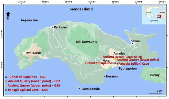
Figure 3.
Satellite map of Samos indicating key locations on the island and the selected geosites.
The Tunnel of Eupalinos—GS1
The tunnel of Eupalinos is situated in the southeastern region of Samos, specifically within the broader vicinity of Pythagorio (Figure 3 and Figure 4). Historically known as the “amphistomon orygma”, as noted by the renowned historian Herodotus, it stands as one of the most remarkable feats in the annals of engineering history. This ambitious endeavor materialized during the rule of Polycrates in 520 BC under the direction of the engineer Eupalinus [36].
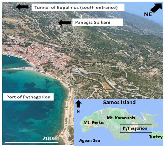
Figure 4.
Sweeping panoramic view showcasing the Pythagorion area, denoting the geotopes of the tunnel of Eupalinus and Panagia Spiliani with clear markings.
The tunnel was constructed to furnish the ancient city of Samos, now known as Pythagorean, with a reliable water supply. This water was sourced from a substantial spring situated further north at the Agiades site (Mount Ambelos, commonly known as Mt. Karvounis). As a result, an extensive water conveyance system spanning a total length of 2385 m was established, wherein 1035 m traversed through an internal tunnel.
The water conduit commenced from the Agiades source, maintaining a constant gradient of 0.6% for the initial 600 m at a relative depth of 2.5 m. The subsequent 260 m followed a steady gradient of 0.75%. The pipeline then entered a 1035-meter-long tunnel, characterized by an almost entirely horizontal alignment. The northern entrance rested at an elevation of 55.48 m, while the southern entrance stood at 55.17 m. The tunnel dimensions measured 1.80 × 1.80 m, featuring a sloping tunnel on its floor measuring 0.6 m in width and up to 10 m in depth. Within this tunnel, semicircular pipes measuring 0.40 m in width were positioned to facilitate water transport. Beyond the southern end of the tunnel, an additional 490-meter-long pipeline extended, utilizing the natural topography to convey water to the town’s reservoir (Figure 5). It is noteworthy that in a bid to expedite construction, excavation was simultaneously initiated from both the northern and southern ends, with minimal deviation upon meeting [37].
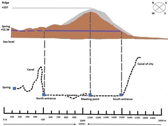
Figure 5.
Simplified profile of the Eupalinos tunnel, [modified [38]].
The Eupalinos tunnel certainly stands out as an architectural marvel, drawing the interest of researchers from various fields [38]. This ancient tunnel is celebrated for its innovative and intricate design, as well as its historical importance. Its primary function was to act as an aqueduct, ensuring a reliable water supply to the ancient city of Samos. It is worth noting that this functionality was intricately linked to the geological features found within the tunnel [38]. The Tunnel of Eupalinos is a testament to the remarkable engineering capabilities of the ancient world, serving both practical and educational purposes. Its historical and hydrological significance emphasizes its status as a monument to human ingenuity.
Regarding its geological attributes, the tunnel traverses Neogene-age lake sediments [39]. These deposits are characterized by compact layers of mica or limestone with a northwesterly orientation. Eupalinus made the strategic decision to tunnel following the strata’s orientation, likely due to the ease of excavation in this manner. The excavation technique proceeded from the bottom to the top, allowing for the roof to rest on a natural layer. The lateral walls were sturdily retained, aligning nearly parallel to the tunnel’s sides. This ingenious design maintains the tunnel’s structural integrity without requiring additional supports or specialized technical interventions. Only a portion of the northern passage necessitated limited interventions, primarily involving support implementation, possibly driven by technical or safety considerations.
Moreover, meticulous measurements conducted within the tunnel highlight its ability to maintain consistent humidity and temperature levels. Specifically, humidity ranges from 82% to 100%, while temperature varies between 15 °C and 17 °C. In contrast, the external environment exhibits more pronounced fluctuations in temperature and humidity. These observations suggest that the Eupalinos tunnel functions as a dual karstic cave [37]. However, it is noteworthy that this cave has been operational for a mere 25 centuries, a relatively brief span that precludes significant cave deposits from forming. Kienast [40], an authority on the tunnel, has indicated the presence of stalagmites and stalactite formations in various sections of the tunnel, causing navigational challenges.
Finally, the Eupalinos tunnel’s innovation stands in stark contrast to classical underground QANAT systems (a Persian word for underground water channels or systems commonly used in arid regions for water supply, developed in ancient Iran by the Persian people sometime in the early 1st millennium BCE and slowly spread westward and eastward from there). In QANATs, the underground aquifer becomes saturated with water, and the tunnel aligns with the aquifer’s gradient until it surfaces as a spring. This approach adheres closely to the geological, hydrological, and stratigraphic features of the aquifer. In contrast, the Eupalinos tunnel disregards the strata’s gradient and groundwater flow direction (northeast). Instead, it bores transversely, directing water along a southeast course. This modification fundamentally alters the water’s trajectory within the tunnel. Thus, from this perspective, the Eupalinos tunnel emerges as a technologically superior solution to QANAT systems [37].
Ancient Quarries of Agiades—GS2 and GS3
The ancient quarries of Agiades are located near the village of Mytilinious, one of the larger settlements on the Samos island (see Figure 3). In this vicinity, a total of 45 caves have been documented, some of which served as entrances to ancient quarries. These entrances feature hand-carved pillars, demonstrating the precise craftsmanship of the miners of that era (Figure 6 and Figure 7). This meticulous construction has allowed these mine entrances to withstand the test of time, remaining structurally sound, without experiencing collapses or structural issues.
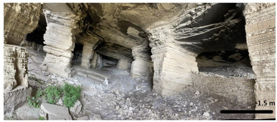
Figure 6.
The interior sight of the lower point of the ancient quarry (GS2).
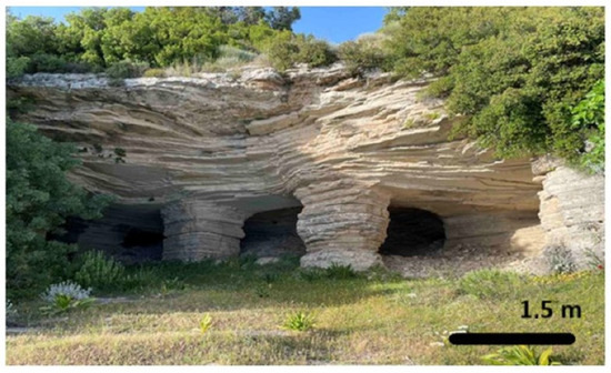
Figure 7.
The interior sight of the upper point of the ancient quarry (GS3).
These quarry sites played a significant role in providing materials for the construction of the grand ancient Temple of Hera, which has been recognized as a UNESCO World Heritage Site since 1992 “https://whc.unesco.org/en/list/595 (accessed on 25 September 2023)” [41]. Additionally, they contributed resources to other historical sites within the ancient city of Samos, now known as Pythagorean. Scholarly investigations have identified two primary phases of mining activity at these sites: the Archaic and Roman periods [42]. Throughout these phases, extensive limestone extraction occurred. Notably, two main sites became central for this extraction and exploitation of limestone resources, as depicted in Figure 6 and Figure 7. These sites also served as sources of nitrate salts, which were crucial for gunpowder production during the 19th century [43].
The larger mining site on Samos Island, as shown in Figure 6 (lower point—GS2), is particularly notable for its impressive dimensions, reaching depths of approximately 50 m, with an average height of around 5 m. The lower point quarry (GS2) is a testament to the skill of ancient miners who provided essential materials for renowned structures like the Temple of Hera. This site is further divided into three sections by walls measuring 1.50 m in width.
The second site (upper point—GS3) is smaller in scale, both in depth and height, but remains a valuable source of mineral resources (see Figure 7). Despite its smaller size, the upper point quarry, GS3, has historical significance due to its contributions to ancient constructions and 19th-century gunpowder production, highlighting its diverse historical roles.
Both geosites, GS2 and GS3, yielded distinctive, hard, porcelaneous, yellowish-brown limestones.
Panagia Spiliani—GS4
The Panagia Spiliani cave is situated in the vicinity of the Pythagorio settlement, positioned at an elevation of 125 m above sea level (Figure 3 and Figure 4). Descending through a series of 95 steps, one enters a spacious cave featuring a dedicated church honoring the Virgin Mary. Initially, this cavern served as a quarry for extracting substantial limestone blocks, employed in the construction of the walls and numerous edifices for the town of Samos.
The Panaghia Spiliani cave is situated within a Neogene lacustrine limestone formation [14]. The cave is renowned for its discovery of the species Dolichopoda giulianae, a cavern-dwelling Orthoptera species belonging to the Rhaphidophoridae family [44]. This species is found across a geographical expanse stretching from the eastern Pyrenees to the Caucasus Mountains, and extending further east to northern Iran’s Alborz Mountains. Most members of this genus exhibit a strong dependence on cave environments. However, notably within the northern part of its distribution range, Dolichopoda populations inhabit a diverse array of settings. These include soil crevices in forests, catacombs, Etruscan tombs, other human-made structures, natural caves, and extensive subterranean karst systems. This demonstrates a spectrum ranging from partially aboveground to entirely subterranean conditions. Their life cycle duration varies depending on the specific habitat they inhabit, showcasing adaptations to diverse environmental factors, encompassing shifting climate patterns and relatively stable conditions [45]. The cave boasts a substantial length of up to 120 m, with an average width spanning 36 m. Its relative depth extends to 8.5 m. Within the cave’s confines stands a temple, while its exterior is adorned by a monastery.
Presently, the cave continues to serve as a site of worship (Figure 8 and Figure 9). However, the extensive and frequent influx of visitors has inadvertently led to detrimental impacts on the cave’s interior decor [46].
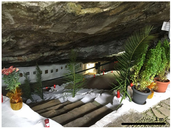
Figure 8.
The entrance of the Panagia Spiliani cave.
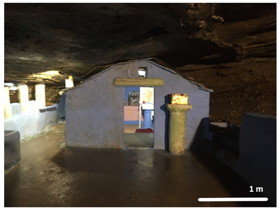
Figure 9.
The interior of the Panagia Spiliani cave (built in the 17th century) with the little church inside.
2.2. Description of the GEOAM
As already stated, the GEOAM (geoeducational assessment method) is a systematic evaluation framework designed to assess the educational value, conservation status, and overall potential of geosites [5]. Incorporating a multidimensional approach, GEOAM employs a set of specific criteria to conduct a thorough assessment of geological features, accessibility, educational resources, visitor experience, and conservation considerations. Through the assignment of scores to individual criteria and subsequent computation of an overall assessment, the method offers a quantifiable gauge of a geosite’s potential for geoeducation. Notably, GEOAM’s flexible structure allows adaptation to diverse geographical contexts and varying site characteristics, making it a versatile tool for educators, researchers, and policymakers striving to identify and enhance the educational significance and sustainable management of geosites [5]. This approach considers eight distinct criteria, each supported by its associated sub-criteria. These criteria form the core framework for our data evaluation and play a pivotal role in assessing the geoeducational potential of geosites.
Site Management and Visitor Experience (SMVE) evaluates the quality of site management and the overall visitor experience. It delves into aspects such as site accessibility, signage, staff knowledge, visitor facilities, site maintenance, safety, and security.
Natural Resource Management (NRM) assesses how well the geosite manages its natural resources. This includes the conservation of biodiversity, preservation of ecosystems, sustainable resource use, pollution prevention and control, and climate change mitigation and adaptation.
Environmental Education and Interpretation (EEI) focuses on the presence of interpretive signage or exhibits, availability of trained interpretive staff or volunteers, integration of environmental education and interpretation, inclusion of interactive activities, and the incorporation of environmentally friendly practices.
Cultural and Historical Significance (CHS) evaluates the historical and cultural value of the geosite. This includes aspects like historical significance, cultural significance, interpretation, cultural diversity, and inclusivity.
Geoethics (GE) assesses the ethical aspects related to the geosite. This criterion includes considerations for environmental impact, cultural heritage preservation, social responsibility, transparency, and professional conduct.
Economic Viability (EV) examines the economic aspects of the geosite. It includes evaluating tourist revenue potential, local economic impact, sustainability of economic benefits, cost-effectiveness of management, and innovative economic models.
Community Involvement and Engagement (CIE) looks at how the geosite involves and engages the local community. It includes aspects like stakeholder participation, cultural sensitivity, community benefits, outreach, and communication.
Sustainable Development (SD) assesses how the geosite contributes to sustainable development. This includes resource efficiency, waste management, biodiversity conservation, social and economic impacts, climate change adaptation, and cultural heritage preservation.
For each criterion, a specific weighting factor is applied to ascertain the ultimate score. Subsequently, the final score is determined using the formula provided below:
Final score: [(SMVE × 0.10) + (NRM × 0.10) + (EEI × 0.30) + (CHS × 0.10) + (GE × 0.20) + (EV × 0.05) + (CIE × 0.05) + (SD × 0.10)]
It is noteworthy to mention that the scoring system allocates values ranging from 1 to 5 for the sub-criteria. Consequently, considering the aforementioned formula for computing the ultimate score, a five-point scale is established for categorizing and determining the final score. This classification of the final score as “High Implementation” (HI), “Moderate Implementation” (MI), or other similar categories provides a quick summary of the level of success in integrating the geoeducational and sustainable principles into the geosite’s management, visitor experience, resource management, and other relevant aspects (Table 1).

Table 1.
Classification of the final GEOAM score.
The scoring process in our research assessment was designed to maintain objectivity through several key steps. Firstly, it involved a team of expert assessors who were well-versed in the relevant criteria and the sites being evaluated. These assessors followed clear and detailed scoring guidelines that outline how each criterion and subcriterion should be assessed and define different score levels. Training was provided to ensure that the assessors understand and can consistently apply these guidelines. Assessments were conducted independently to minimize bias, with each assessor evaluating sites separately. After individual assessments, a review process checked for scoring consistency, and any significant discrepancies were resolved through discussions or revisions. Transparency was maintained throughout the process, documenting how the scores were determined and including relevant comments or justifications. Finally, many research papers and assessments were subjected to a peer review by other experts in the field to ensure that the methodology and findings are sound and objective.
3. Results
Geosites Assessment and Scores
The evaluation of the criteria using the GEOAM intricately revealed the following results (Table 2, Table 3, Table 4, Table 5, Table 6, Table 7, Table 8 and Table 9):
Table 2.
Scoring system for the geosites of Samos on SMVE.
Table 3.
Scoring system for the geosites of Samos on NRM.
Table 4.
Scoring system for the geosites of Samos on EEI.
Table 5.
Scoring system for the geosites of Samos on CHS.
Table 6.
Scoring system for the geosites of Samos on GE.
Table 7.
Scoring system for the geosites of Samos on EV.
Table 8.
Scoring system for the geosites of Samos on CIE.
Table 9.
Scoring system for the geosites of Samos on SD.
The assessment incorporated a weighted scoring system that takes into account the relative importance of each criterion, providing a holistic view of the sites’ strengths and areas for development (Table 10).
Table 10.
Scoring system for the geosites of Samos and the final scores.
Based on the comprehensive assessment, the Tunnel of Eupalinos, referred to as GS1, exhibits strong performance across various criteria. It achieves the highest final score of 3.63, classifying it as “High Implementation” (HI). GS1 excels in site management, visitor experience, natural resource management, cultural and historical significance, geoethics, economic viability, community involvement, and sustainable development aspects. This highlights its commitment to combining geoeducational principles, sustainable practices, and community engagement. Notably, the high score in the Geoethics category reflects its integration of environmental impact, cultural heritage, social responsibility, transparency, and professional conduct. While GS1 sets a commendable benchmark, there are still opportunities for improvement, particularly in environmental education and interpretation (EEI).
In this light, we mention, by way of example that the implementation of interactive exhibits illustrating geological formations, ancient engineering techniques, and the tunnel’s historical context could engage visitors more deeply. Interpretive signage explaining the geological processes behind the tunnel’s creation and its place in the historical landscape could offer a profound understanding of its significance. Enhancing these elements could transform the tunnel into an educational platform celebrating both ancient engineering and geological processes. Such initiatives may inspire wonder and curiosity among visitors, encouraging exploration of the intersection of human innovation and Earth’s geological evolution.
Regarding the two distinct geosites within the Ancient Quarries of Agiades, characterized by their unique geological and historical features, the assessment reveals the following:
GS2—The lower-point Quarry demonstrates a moderate performance, with a final score of 2.00, categorizing it as “Moderate Implementation” (MI). It presents opportunities for improvement in site management, visitor experience, natural resource management, and community involvement. While there’s room for growth, GS2 exhibits promising attributes. Its performance suggests a balanced approach with the potential to enhance community engagement, integrate geoethical principles, and develop educational programs for a more comprehensive visitor experience. GS2 forms the basis for geoeducational and sustainable initiatives, with room for improvement.
GS3—The upper-point Quarry shows moderate to promising performance, with a final score of 2.86, leaning toward “High Implementation” (HI). It excels in site accessibility, conservation efforts, and cultural and historical significance, providing a solid foundation for effective geoeducation and sustainability initiatives. While GS3’s performance is promising, there is room to improve environmental education and interpretation, along with the integration of geoethical considerations to enhance the visitor experience. Strengthening community involvement and economic viability aspects could contribute to overall sustainability. GS3’s performance indicates the potential for effectively promoting geoeducation and sustainable practices through targeted enhancements.
In both geosites, strategies emphasizing limestone’s role in shaping historical structures, delving into ancient mining techniques, and exploring the broader geological context could captivate visitors and deepen their appreciation for the geological foundations of human achievements [47,48,49].
GS4 showcases a relatively favorable performance in both geoeducational and sustainable practices, earning a final score of 2.86, indicating “Moderate Implementation” (MI) but leaning towards “High Implementation” (HI). The geosite excels in site accessibility, staff knowledge, visitor interaction, site maintenance, safety, and security, emphasizing its dedication to providing a safe and enriching experience for visitors. GS4’s performance suggests a potential to serve as an effective educational and sustainable site. While there are areas for potential improvement, such as enhancing environmental education, interpretation, cultural significance, and community engagement, focusing on these aspects could elevate the geosite’s impact and educational value. In other words, GS4 demonstrates potential for contributing significantly to educational and sustainable initiatives while offering a positive and accessible experience for visitors.
Indeed, Panagia Spiliani cave’s dual role as a place of worship and a geological site accentuates its uniqueness. The assessment brings to light the importance of preserving its delicate interior, given its religious and geological significance. Integrating environmental education and interpretation strategies that educate visitors about the cave’s geological formations, its role in preserving the Dolichopoda giulianae species, and the need for responsible tourism could foster a deeper understanding of its com-bined values. Creating a platform for discussing responsible tourism practices at Panagia Spiliani Cave involves implementing guided interpretive tours, interactive displays, and educational workshops to deepen visitors’ understanding of the cave’s geological significance and delicate ecosystem. Setting clear visitor codes of conduct, limiting visitor numbers, and training guides in geoethics ensure respectful behavior and minimize ecological impact [50]. Balancing minimal infrastructure development, regular ecological monitoring, and community engagement fosters a harmonious environment where visitors can pledge to uphold responsible tourism practices, preserving the cave’s sanctity while nurturing its geological and ecological health [50,51].
4. Discussion
4.1. The Effectiveness of the GEOAM
The comprehensive assessment and subsequent discussion of the selected geosites using the GEOAM method highlight its effective role as a holistic tool for revealing the geoeducational potential of these sites. The method’s structured criteria cover site management, conservation, education, cultural value, geoethics, economic viability, community engagement, and sustainable development, creating a robust framework for assessing geosites’ multifaceted attributes. The outcomes guide targeted strategies to enhance educational value and sustainability while promoting responsible environmental engagement. GEOAM stands out among other assessment methods [52,53,54,55,56,57,58,59,60,61,62,63,64,65] due to its comprehensive and multidimensional approach, encompassing site management, environmental education, cultural significance, and geoethics. Its versatility accommodates diverse geosites and contexts, although specialized methods might excel in certain areas like ecology or economics. The method’s selection should align with assessment objectives and geosite characteristics.
4.2. Required Skills for Successful GEOAM Implementation
Implementing GEOAM effectively demands a multidisciplinary approach that integrates technical, analytical, and communication skills, underpinned by a profound understanding of geology, education, and sustainable development principles. Those tasked with GEOAM implementation must possess a robust geology foundation to grasp the intricate geological attributes and significance of assessed geosites. Proficiency in data collection and analysis assumes paramount importance in the evaluation process, encompassing diverse criteria and subcriteria critical for determining a geosite’s geoeducational potential.
The assessment process commences with rigorous data collection, entailing meticulous observations of each geosite. Observers adhere to well-defined criteria for each aspect under evaluation, spanning site management, natural resource management, and cultural significance. These criteria serve as unequivocal benchmarks, ensuring objectivity. For instance, assessing site accessibility involves quantifiable parameters like walking distances, signage quality, and barrier-free access. Similarly, biodiversity conservation assessment may necessitate the identification of plant and animal species.
Professionals well-versed in environmental education play an indispensable role in evaluating a geosite’s capacity to convey geological concepts effectively to visitors. They scrutinize the presence and quality of interpretive materials, signage clarity, and the availability of trained staff for explanations. Understanding cultural and historical contexts assumes equal significance, aiding in the assessment of a geosite’s cultural relevance. Observers delve into historical narratives linked with the site, evaluate cultural diversity, and gauge inclusivity.
Furthermore, a comprehensive grasp of sustainable development principles proves indispensable for evaluating a geosite’s contribution to long-term environmental and socio-economic well-being. This involves assessing resource efficiency, waste management practices, and the site’s impact on the local community and economy. Observers collect data on economic benefits, social engagement efforts, and adherence to ethical and environmental standards.
The objectivity and reliability of results throughout the evaluation process are upheld through strict adherence to standardized observation protocols. Observers undergo training to minimize subjectivity and ensure scoring consistency. This meticulous and systematic approach ensures that assessments accurately reflect geosites’ performance across various dimensions.
Additionally, an interdisciplinary approach, as advocated by Petterson [66], facilitates collaboration across diverse fields like geology, education, and conservation, ensuring a holistic assessment. Critical thinking skills are requisite for data analysis, criteria weighing, and determining a geosite’s overall educational value. Effective communication skills are equally pivotal for disseminating assessment results to stakeholders, ranging from researchers to policymakers and the general public. Adaptability is essential, given the unique attributes of each geosite, necessitating tailored assessment approaches. Problem-solving skills come into play when addressing challenges during the assessment process. Ethical considerations [67,68,69,70,71,72,73,74], particularly pertaining to geoethics and responsible tourism practices, must be integrated into the assessment framework to ensure equitable evaluations.
Addressing the existing knowledge gap in geology is paramount for the effective deployment of GEOAM. This entails emphasizing geoeducation in school curricula and bolstering the presence of geologists [75,76]. Closing this educational gap equips individuals with the necessary skills to proficiently utilize GEOAM, fostering a deep understanding of geological principles and enhancing the foundation for effective assessment. Moreover, increased availability of geologists can provide critical expertise and support, augmenting the accuracy and efficacy of GEOAM deployment.
Strengthening geo-environmental education within curricula is undeniably imperative. It serves as the gateway to a profound comprehension of Earth’s intricate processes, natural resources, and their interplay with human activities. Such education empowers individuals with the knowledge and awareness essential to comprehend the environmental challenges we face and the actions required for sustainable coexistence. By integrating geo-environmental education into curricula, we empower future generations to make informed decisions, engage in responsible behaviors, and contribute to the preservation of our planet for current and future populations. This need intensifies as global environmental issues escalate, underscoring the urgent necessity for comprehensive education bridging the gap between geological understanding and environmental stewardship.
4.3. Limitations in Assessing Geoeducational Potential Using GEOAM
When utilizing the GEOAM method for assessing the geoeducational potential of geosites, there exist several noteworthy limitations that warrant consideration [5]. The subjectivity inherent in scoring and interpretation is a crucial aspect to bear in mind, as different evaluators might assign scores differently, potentially leading to variations in assessment outcomes. The subjectivity in scoring and potential variations in interpretation though not evident in the provided data and analysis directly, it is a common concern in any scoring-based assessment. Furthermore, the method’s effectiveness is contingent on the availability and accuracy of data; instances where data is limited or incomplete could result in an incomplete representation of a geosite’s attributes. Additionally, while simplifying criteria aids in the assessment process, the challenge arises when certain nuanced attributes do not align neatly with predefined categories.
Another significant limitation arises from the assignment of weighting factors to criteria and subcriteria. Such factors might not universally reflect the priorities of all stakeholders, potentially introducing disparities in the evaluation outcomes. Furthermore, given the dynamic nature of geosites, which evolve due to natural processes, human interventions, and evolving societal values, the assessment might not entirely capture these temporal changes. Moreover, the method’s capacity to consider the unique context and specific attributes of each geosite could be limited, leading to a less precise evaluation.
While these limitations underline the need for cautious interpretation of the GEOAM results, they also emphasize the importance of integrating the method with other evaluation approaches. By doing so, the shortcomings of one method can be complemented by the strengths of another. As the field of geosite assessment evolves, continuous refinement of the GEOAM method based on practical experience and constructive feedback becomes indispensable to mitigate these limitations and enhance its overall effectiveness in capturing the multifaceted geoeducational potential of diverse geosites.
5. Conclusions
Incorporating our case study of the Tunnel of Eupalinos, the Ancient Quarries of Agiades, and Panagia Spiliani cave, in Samos, Aegean Sea, Greece, the effectiveness of the GEOAM in evaluating the geoeducational potential of geosites becomes evident. The assessment’s outcomes offer valuable insights for enhancing the educational and sustainable impact of these sites, guiding focused strategies to promote geological comprehension and responsible environmental engagement. The case study notably highlights the pressing need to address the deficiency in foundational geological knowledge by emphasizing geoeducation in schools and bolstering the presence of geologists. While acknowledging the limitations of the GEOAM, such as subjectivity in scoring and data availability challenges, this study underscores the method’s significance in fostering a holistic approach by integrating geoethics. Through harmonizing geoeducation, geoethics, and assessment, GEOAM presents a robust framework aligning with societal goals of cultivating geological understanding and responsible environmental stewardship.
Author Contributions
Conceptualization, G.Z. and H.D.; methodology, G.Z. and H.D.; formal analysis, G.Z.; investigation, G.Z.; resources, G.Z.; data curation, G.Z.; writing—original draft preparation, G.Z.; writing—review and editing, H.D.; supervision, H.D. All authors have read and agreed to the published version of the manuscript.
Funding
This research received no external funding.
Data Availability Statement
The data presented in this study are available on request from the corresponding author.
Acknowledgments
The authors gratefully thank the journal editor and the three reviewers for their thorough consideration of this paper.
Conflicts of Interest
The authors declare no conflict of interest.
References
- Herrera-Franco, G.; Carrión-Mero, P.; Montalván-Burbano, N.; Caicedo-Potosí, J.; Berrezueta, E. Geoheritage and geosites: A bibliometric analysis and literature review. Geosciences 2022, 12, 169. [Google Scholar] [CrossRef]
- Berrezueta, E.; Sánchez-Cortez, J.L.; Aguilar-Aguilar, M. Inventory and characterization of geosites in Ecuador: A review. Geoheritage 2021, 13, 93. [Google Scholar] [CrossRef]
- Zafeiropoulos, G.; Drinia, H.; Antonarakou, A.; Zouros, N. From Geoheritage to Geoeducation, Geoethics and Geotourism: A critical evaluation of the Greek region. Geosciences 2021, 11, 381. [Google Scholar] [CrossRef]
- Németh, B.; Németh, K.; Procter, J.N. Visitation Rate Analysis of Geoheritage Features from Earth Science Education Perspective Using Automated Landform Classification and Crowdsourcing: A Geoeducation Capacity Map of the Auckland Volcanic Field, New Zealand. Geosciences 2021, 11, 480. [Google Scholar] [CrossRef]
- Zafeiropoulos, G.; Drinia, H. GEOAM: A Holistic Assessment Tool for Unveiling the Geoeducational Potential of Geosites. Geosciences 2023, 13, 210. [Google Scholar] [CrossRef]
- Evelpidou, N.; Vassilopoulos, A.; Leonidopoulou, D.; Poulos, S. An investigation of the coastal erosion causes in Samos Island, Eastern Aegean Sea. J. Landsc. Ecol. 2008, 6, 295–310. [Google Scholar]
- McKenzie, D.P. Plate tectonics in the Mediterranean Region. Nature 1970, 226, 239–243. [Google Scholar] [CrossRef]
- McKenzie, D.P. Active tectonics of the Mediterranean Region. Geophys. J. Int. 1972, 30, 109–185. [Google Scholar] [CrossRef]
- McKenzie, D. Active tectonics of the Alpine—Himalayan belt: The Aegean Sea and surrounding regions. Geophys. J. Int. 1978, 55, 217–254. [Google Scholar] [CrossRef]
- Papanikolaou, D. The three metamorphic belts of the Hellenides. A review and a kin-ematic interpretation. Geol. Soc. Lond. Spec. Publ. 1984, 17, 551–561. [Google Scholar] [CrossRef]
- Theodoropoulos, D. Geological Map of Greece, 1:50.000 Scale; Neon Karlovasi and Limin Vatheos Sheets; IGME: Athens, Greece, 1979. [Google Scholar]
- Papanikolaou, D. Unités tectoniques et phases de déformation dans I’ île de Samos, Mer Egée, Grèce. Bull. Soc. Géol. Fr. 1979, 7, 745–752. [Google Scholar] [CrossRef]
- Papanikolaou, D. The Geology of Greece; Patakis Publ. Co.: Athens, Greece, 2015; p. 443. (In Greek) [Google Scholar]
- Ring, U.; Laws, S.; Bernet, M. Structural analysis of a complex nappe sequence and late orogenic basins from the Aegean island of Samos, Greece. J. Struct. Geol. 1999, 21, 1575–1601. [Google Scholar] [CrossRef]
- Roche, V.; Jolivet, L.; Papanikolaou, D.; Bozkurt, E.; Menant, A.; Rimmele, G. Slab fragmentation beneath the Aegean/Anatolia transition zone: Insights from the tectonic and metamorphic evolution of the Eastern Aegean region. Tectonophysics 2019, 754, 101–129. [Google Scholar] [CrossRef]
- Chatzipetros, A.; Kiratzi, A.; Sboras, S.; Zouros, N.; Pavlides, S. Active faulting in the north-eastern Aegean Sea Islands. Tectonophysics 2013, 597–598, 106–122. [Google Scholar] [CrossRef]
- Angelier, J. Sur l’alternance mio-quaternaire de mouvements extensifs et compressifs en Εgee orientale: L’ ile de Samos. C. R. Acad. Sci. 1976, 283, 463–466. [Google Scholar]
- Nomikou, P.; Evangelidis, D.; Papanikolaou, D.; Lampridou, D.; Litsas, D.; Tsaparas, Y.; Koliopanos, I. Morphotectonic analysis along the northern Margin of Samos Island, related to the seismic activity of October 2020, Aegean Sea, Greece. Geosciences 2021, 11, 102. [Google Scholar] [CrossRef]
- Nomikou, P.; Evangelidis, D.; Papanikolaou, D.; Lampridou, D.; Litsas, D.; Tsaparas, Y.; Koliopanos, I.; Petroulia, M. Co-existence of active EW normal faulting and NE-SW strike-slip faulting in the Eastern Aegean Islands; evidence from offshore studies in Lesvos and Samos, Greece. In Proceedings of the EGU General Assembly Conference Abstracts 2022, Vienna, Austria, 23–27 May 2022; p. EGU22-9864. [Google Scholar] [CrossRef]
- Aksu, A.E.; Piper, D.J.W.; Konuk, T. Quaternary growth patterns of Buyuk Menderes and Kuyuk Menderes deltas, western Turkey. Sediment. Geol. 1987, 52, 227–250. [Google Scholar] [CrossRef]
- Taymaz, T.; Jackson, J.A.; McKenzie, D. Active tectonics of the north and central Aegean Sea. Geophys. J. Int. 1991, 106, 433–490. [Google Scholar] [CrossRef]
- Seyitoglu, G.; Scott, B.C. The cause of NS extensional tectonics in western Turkey: Tec-tonic escape vs. back-arc spreading vs. orogenic collapse. J. Geodyn. 1996, 22, 145–153. [Google Scholar] [CrossRef]
- Yilmaz, Y.; Genç, Ş.C.; Gürer, F.; Bozcu, M.; Yilmaz, K.; Karacik, Z.; Altunkaynak, Ş.; Elmas, A. When did the western Anatolian grabens begin to develop? Geol. Soc. Lond. Spec. Publ. 2000, 173, 353–384. [Google Scholar] [CrossRef]
- Stiros, S.C.; Laborel, J.; Laborel-Deguen, F.; Papageorgiou, S.; Evin, J.; Pirazzoli, P.A. Seismic coastal uplift in a region of subsidence: Holocene raised shorelines of Samos Island, Aegean Sea, Greece. Mar. Geol. 2000, 170, 41–58. [Google Scholar] [CrossRef]
- Kouskouna, V. Updating the macroseismic intensity database of 19th century damaging earthquakes in Greece: A case study in Samos Island. Acta Geophys. 2021, 69, 1101–1111. [Google Scholar] [CrossRef]
- Kiratzi, A.; Papazachos, C.; Özacar, A.; Pinar, A.; Kkallas, C.; Sopaci, E. Characteristics of the 2020 Samos earthquake (Aegean Sea) using seismic data. Bull. Earthq. Eng. 2021, 20, 7713–7735. [Google Scholar] [CrossRef]
- Mountrakis, D. Tertiary and Quaternary tectonics of Greece. In Postcollisional Tectonics and Magmatism in the Mediterranean Region and Asia; Special Papers 2006; Geological Society of America: Boulder, CO, USA, 2006. [Google Scholar] [CrossRef]
- Solounias, N.; Ring, U. Ancient history of the Samos fossils and the record of earthquakes. J. Virtual Explor. 2007, 28, 6. [Google Scholar]
- Solounias, N.; Rivals, F.; Semprebon, G.M. Dietary interpretation and paleoecology of herbivores from Pikermi and Samos (late Miocene of Greece). Paleobiology 2010, 36, 113–136. [Google Scholar] [CrossRef]
- Solounias, N. Mammalian fossils of Samos and Pikermi, II. Resurrection of a classic Turolian fauna. Ann. Carnegie Mus. 1981, 50, 231–270. [Google Scholar] [CrossRef]
- Solounias, N. The Turolian fauna from the Island of Samos, Greece. Contrib. Vertebr. Evol. 1981, 6, 1–232. [Google Scholar]
- Solounias, N.; Mayor, A. Ancient references to the fossils from the land of Pythagoras. Earth Sci. Hist. 2004, 23, 283–296. [Google Scholar] [CrossRef]
- Axelrod, D.I. Evolution and biogeography of Madrean-Tethyan sclerophyll vegetation. Ann. Mo. Bot. Gard. 1975, 72, 280–334. [Google Scholar] [CrossRef]
- Orgeta, M. Erste Ergebnisse einer palynologischen Unterschuchung der Lignite von Pikermi/Attica. Ann. Géologiques Des Pays Helléniques 1979, 2, 909–921. [Google Scholar]
- Ioakim, C.; Solounias, N. A radiometrically dated pollen flora from the Upper Miocene of Samos Island, Greece. Rev. Micropaléontol. 1985, 28, 197–204. [Google Scholar]
- Angistalis, G.; Dounias, G.; Tsokas, G.; Zambas, C. The Walls of Eupalinos Aqueduct, Samos Island, Greece. Description, Pathology and Proposed Restoration Measures. Bull. Geol. Soc. Greece 2018, 53, 193–228. [Google Scholar] [CrossRef]
- Seitanidis, G.; Margoni, S.; Psilovikos, A. Monitoring of Efpalinos tunnel of Samos, an ancient hydraulic water supply work operating as a dynamic karstic cave. Bull. Geol. Soc. Greece 2006, 39, 1–11. [Google Scholar]
- Seitanidis, G. Morphological Hydrological and Environmental Elements Connected to the Eupaline Tunnel of Samos. Master’s Thesis, Geography and Environment Major, Department of Geology, Aristotle University of Thessaloniki, Thessaloniki, Greece, 2003. [Google Scholar]
- Meissner, B. Das Neogene von Ost-Samos. Sedimentationgeschichte und Korrelation, Neues Jahrbuch für Geologie und Paläontologie Abhandlung; Separtdruck: Lobnitz, Germany, 1976; Volume 152, pp. 161–176. [Google Scholar]
- Kienast, H. Die Wasserleitung des Eupalinos auf Samos; Deutsches Archäologisches Institut: Bohn, Germany, 1995. [Google Scholar]
- Kienast, H. Topographische Studien im Heraion von Samos. Archäologisher Anz. 1992, 1992, 171–213. [Google Scholar]
- Tziligkaki, E.; Stamatakis, M. Underground quarries in the area of Agiades, Samos Island, Greece: Notes on historical topography and chronology. Bull. Geol. Soc. Greece 2018, 53, 161–192. [Google Scholar] [CrossRef]
- Stamatakis, M.; Zagouroglou, K. On the occurrence of niter, Samos Island, Greece. Miner. Wealth 1984, 33, 17–20. [Google Scholar]
- Rampini, M.; Di Russo, C.; Taylan, M.S.; Gelosa, A.; Cobolli, M. Four new species of Dolichopoda Bolivar, 1880 from Southern Sporades and Western Turkey (Orthoptera, Rhaphidophoridae, Dolichopodainae). ZooKeys 2012, 201, 43–58. [Google Scholar] [CrossRef][Green Version]
- Di Russo, C.; Carchini, G.; Sbordoni, V. Life-history variation in Dolichopoda cave crickets. In Insect Life-Cycle Polimorphism; Danks, H.V., Ed.; Kluwer Academy Publisher: Dordrecht, The Netherlands, 1994; pp. 205–226. [Google Scholar] [CrossRef]
- Kirdis, S.; Papadopoulos, G. Speleological research in Samos Island. Bull. Greek Speleol. Soc. 2000, 22, 147–162. [Google Scholar]
- Spathis, P.K.; Mavrommati, M.; Gkrava, E.; Tsiridis, V.; Evgenidis, S.P.; Karapanagiotis, I.; Melfos, V.; Karapantsios, T.D. Characterization of Natural Stone from the Archaeological Site of Pella, Macedonia, Northern Greece. Heritage 2021, 4, 4665–4677. [Google Scholar] [CrossRef]
- Baczyńska, E.; Lorenc, M.W.; Kaźmierczak, U. The landscape attractiveness of aban-doned quarries. Geoheritage 2017, 10, 271–285. [Google Scholar] [CrossRef]
- Kurowska, E.E.; Czerniak, A.; Bańkowski, J. The Rationale for Restoration of Aban-doned Quarries in Forests of the Ślęża Massif (Poland) in the Context of Sustainable Tourism and Forest Environment Protection. Forests 2023, 14, 1386. [Google Scholar] [CrossRef]
- Bohle, M.; Marone, E. Geoethics, a Branding for Sustainable Practices. Sustainability 2021, 13, 895. [Google Scholar] [CrossRef]
- Peppoloni, S.; Di Capua, G. Geoethics to Start Up a Pedagogical and Political Path to-wards Future Sustainable Societies. Sustainability 2021, 13, 10024. [Google Scholar] [CrossRef]
- Panizza, M. Geomorphosites: Concepts, methods and examples of geomorphological survey. Chin. Sci. Bull. 2001, 46, 4–5. [Google Scholar] [CrossRef]
- Trueba, J.J.G.; Cañadas, E.S. La valoración del patrimonio geomorfológico en espacios naturales protegidos. Su aplicación al parque nacional de los picos de Europa. Bull. Assoc. Span. Geogr. 2008, 47, 175–194. Available online: http://hdl.handle.net/10902/2734 (accessed on 10 August 2023).
- De Wever, P.; Baudin, F.; Pereira, D.; Cornee, A.; Egoroff, G.; Page, K. The Importance of Geosites and Heritage Stones in Cities—A Review. Geoheritage 2017, 9, 561–575. [Google Scholar] [CrossRef]
- Reynard, E.; Fontana, G.; Kozlik, L.; Scapozza, C. A method for assessing the scientific and additional values of geomorphosites. Geogr. Helv. 2007, 62, 148–158. [Google Scholar] [CrossRef]
- Ruban, D.A. Quantification of geodiversity and its loss. Proc. Geologist. Assoc. 2010, 121, 326–333. [Google Scholar] [CrossRef]
- Ruban, D.A. Geotourism—A geographical review of the literature. Tour. Manag. Perspect. 2015, 15, 1–15. [Google Scholar] [CrossRef]
- Skentos, A. Geotopes of Greece. Master’s Thesis, University of Athens, Athens, Greece, 2012. [Google Scholar]
- Brilha, J.B. Inventory and Quantitative Assessment of Geosites and Geodiversity Sites: A Review. Geoheritage 2016, 8, 119–134. [Google Scholar] [CrossRef]
- Henriques, M.H.; Brilha, J. UNESCO Global Geoparks: A strategy towards global understanding and sustainability. Episodes 2017, 40, 349–355. [Google Scholar] [CrossRef]
- Bruschi, V.M.; Coratza, P. Geoheritage and Environmental Impact Assessment (EIA). In Geoheritage: Assessment, Protection and Management; Reynard, E., Brilha, J., Eds.; Elsevier: Amsterdam, The Netherlands, 2018; pp. 251–264. [Google Scholar]
- Zwoliński, Z.; Najwer, A.; Giardino, M. Methods for Assessing Geodiversity. In Geoheritage: Assessment, Protection, and Management; Reynard, E., Brilha, J., Eds.; Elsevier: Amsterdam, The Netherlands, 2018; pp. 27–52. [Google Scholar]
- Drinia, H.; Tsipra, T.; Panagiaris, G.; Patsoules, M.; Papantoniou, C.; Magganas, A. Geological heritage of Syros Island, Cyclades complex, Greece: An assessment and geotourism perspectives. Geosciences 2021, 11, 138. [Google Scholar] [CrossRef]
- Fassoulas, C.; Mouriki, D.; Dimitriou-Nikolakis, P.; Iliopoulos, G. Quantitative Assessment of Geotopes as an Effective Tool for Geoheritage Management. Geoheritage 2012, 4, 177–193. [Google Scholar] [CrossRef]
- Suzuki, D.A.; Takagi, H. Evaluation of geosite for sustainable planning and management in geotourism. Geoheritage 2018, 10, 123–135. [Google Scholar] [CrossRef]
- Petterson, M. Interconnected geoscience for international development. Epis. J. Int. Geosci. 2019, 42, 225–233. [Google Scholar] [CrossRef]
- Procesi, M.; Di Capua, G.; Peppoloni, S.; Corirossi, M.; Valentinelli, A. Science and Citizen Collaboration as Good Example of Geoethics for Recovering a Natural Site in the Urban Area of Rome (Italy). Sustainability 2022, 14, 4429. [Google Scholar] [CrossRef]
- Marjanović, M.; Radivojević, A.; Antić, A.; Peppoloni, S.; Di Capua, G.; Lazarević, J.; Marković, R.; Tomić, N.; Milićević, A.; Langović, Z.; et al. Geotourism and geoethics as support for rural development in the Knjaževac municipality, Serbia. Open Geosci. 2022, 14, 794–812. [Google Scholar] [CrossRef]
- Kubalíková, L.; Bajer, A.; Balková, M.; Kirchner, K.; Machar, I. Geodiversity Action Plans as a Tool for Developing Sustainable Tourism and Environmental Education. Sustainability 2022, 14, 6043. [Google Scholar] [CrossRef]
- Vasconcelos, C.; Orion, N. Earth Science Education as a Key Component of Education for Sustainability. Sustainability 2021, 13, 1316. [Google Scholar] [CrossRef]
- Di Capua, G.; Peppoloni, S. Defining Geoethics. Website of the IAPG—International Association for Promoting Geoethics. 2019. Available online: http://www.geoethics.org/definition (accessed on 25 September 2023).
- Peppoloni, S.; Di Capua, G. Geoethics: Ethical, Social and Cultural Implications in Geosciences. Ann. Geophys. 2017, 60, 7. [Google Scholar] [CrossRef]
- Mogk, D. Geoethics and professionalism: The responsible conduct of scientists. Ann. Geophys. 2017, 60, 12. [Google Scholar] [CrossRef]
- Peppoloni, S.; Di Capua, G. Geoethics and geological culture: Awareness, responsibility and challenges. Ann. Geophys. 2012, 55, 335–341. [Google Scholar] [CrossRef]
- Georgousis, E.; Savelides, S.; Mosios, S.; Holokolos, M.V.; Drinia, H. The need for geoethical awareness: The importance of geoenvironmental education in geoheritage understanding in the case of Meteora geomorphes, Greece. Sustainability 2021, 13, 6626. [Google Scholar] [CrossRef]
- Mosios, S.; Georgousis, E.; Drinia, H. The Status of Geoethical Thinking in the Educational System of Greece: An Overview. Geosciences 2023, 13, 37. [Google Scholar] [CrossRef]
Disclaimer/Publisher’s Note: The statements, opinions and data contained in all publications are solely those of the individual author(s) and contributor(s) and not of MDPI and/or the editor(s). MDPI and/or the editor(s) disclaim responsibility for any injury to people or property resulting from any ideas, methods, instructions or products referred to in the content. |
© 2023 by the authors. Licensee MDPI, Basel, Switzerland. This article is an open access article distributed under the terms and conditions of the Creative Commons Attribution (CC BY) license (https://creativecommons.org/licenses/by/4.0/).