Article

Digital Tools to Serve Geotourism and Sustainable Development at Psiloritis UNESCO Global Geopark in COVID Times and Beyond

by
Charalampos Fassoulas
1,*,
Emmanouel Nikolakakis
2 and
Spiridon Staridas
3
1
Natural History Museum of Crete, University of Crete, 71409 Heraklion, Crete, Greece
2
Unit of Communication & Networking (UCNET), University of Crete, 70013 Heraklion, Crete, Greece
3
Staridas Geography, 71201 Heraklion, Crete, Greece
*
Author to whom correspondence should be addressed.
Geosciences 2022, 12(2), 78; https://doi.org/10.3390/geosciences12020078
Submission received: 30 December 2021 / Revised: 21 January 2022 / Accepted: 27 January 2022 / Published: 7 February 2022

Abstract

:
Digital tools that aid geolocation, geointerpretation and geomodelling are increasingly used in the promotion of geoheritage and geoconservation. UNESCO Global Geoparks (UGGps) are complex regions that require a variety of approaches to advance geoconservation and public awareness, holistic heritage management and sustainable development. UGGps need more diversified and applied digital tools to address these subjects. Additional efforts are made through their commitment to achieving sustainable development goals (SDGs) in the changing and challenging world of the COVID-19 pandemic and the exacerbation of climate change. In this study, we present three new digital applications developed for the Psiloritis UGGp in Southern Greece. These digital tools were developed under the implementation of the “Enhancement Plan” of the geopark via the RURITAGE, a project that supports rural regeneration through conservation, with a focus on local heritage. Digital tools developed in the project include an interactive digital map that demonstrates all properties of local heritage, products and services, two story maps focusing on historic churches and monasteries of the Amari district and on the natural and cultural values of Nida plateau, and a business-listing map with the affiliated geopark enterprises. These digital tools combine multiple applications and methods such as Wordpress webpages, web maps, spherical panoramas, multimedia, site interpretation, geolocation and virtual reality to aid the interpretation of natural and cultural heritage, promote important sites, demonstrate overlaps between nature and human society and support local productivity. Digital tools offer online access to interested parties in any area and are also used for in situ information sites. They are user-friendly, device-adjusted and available for sharing on social media and webpages. The applicability and effectiveness of these digital tools are proven to advance geotourism and the SDGs, in line with the provisions of the “World After roadmap” of UGGps. During the COVID-19 pandemic, the “visibility” of the Psiloritis UGGp was doubled via the use of these digital tools, as they have become popular among the general public.

1. Introduction

Living in challenging times, i.e., in 2020 and 2021 during the COVID-19 pandemic, requires flexibility, innovation and adaptation, not only for our physical well-being, but for the continuation of our activities, services and products. The shock of the COVID-19 pandemic affected all sectors of social and economic life. The pandemic was particularly devastating to tourism, especially in 2020. Global traveling was banned by 90% of all countries, resulting in a 70–80% decrease in flights and overnight stays, consequently reducing tourism-related income [1].
Among those seriously affected by the effects of the pandemic on tourism are the UNESCO Global Geoparks (UGGps), which depend on geotourism for their sustainable development [2]. By limiting travel, most activities and services in geoparks were frozen, minimizing the income for management structures and inhabitants. The essential connection between geoparks, their stakeholders and their visitors was threatened. To mitigate this problem, geoparks initiated the development of digital initiatives and services to communicate with their inhabitants, promote their territory and support local products and producers [3].
The application of digital technologies in geoparks was initiated before the pandemic. Cayla [4] reported digital technologies used for the management of geoheritage in various geoparks and protected areas, including geolocation and digital mapping, digital imaging and modeling, and hybrid environments (virtual and augmented reality). Laser scanning, digital monitoring and 3D modeling were also implemented in several geoparks and nature parks in France for the study, management, and promotion of karstic systems [5]. The Magma UGGp was possibly the first to integrate virtual reality into the communication and interpretation of geological phenomena under the GEOvisual project in 2015 [6]. In the Sesia Val Grande UGGp, virtual geotrips and digital maps were utilized to enrich geotourism [7]. Special mobile applications have been developed to interpret and communicate geoheritage through the building stones of Torino, Rome and Lausanne [8,9], and to strengthen geoeducation along geotrails [10,11,12]. Similar applications have been developed in Asia to promote geointerpretation and geoeducation, such as in Mudeung UGGp in Korea [13], and several other Chinese geoparks [14].
The reason for the influx of digital technologies in geointerpretation and promotion is apparent. Digital tools are adaptable, easily modified and updated, open to all, used online and in situ, combine variable resources and means, and are supported by many types of devices (PCs, laptops, tablets, mobile phones, etc.). Digital technologies are user-friendly and openly accepted by younger people, making them suitable for training and education. During the last decade, we have become witnesses of a fast-evolving technology, known as “Accelerating Change” [15], which is pushing technological development to provide products more quickly to a wider demographic range for diversified applications. As more companies invest in a particular field, digital technology changes are accelerated, and target groups increase in size. Virtual reality (VR) is greatly accelerating in development, especially following the commitment of Facebook (also known as Meta since October 2021) to VR and augmented reality (AR) services (https://www.bbc.com/news/technology-58749529, accessed on 28 December 2021).
Digital technology plays a fundamental role in achieving sustainable development goals (SDGs) [16] if it follows the values of equality, harmony with society and the environment and self-determination for our common future [17,18,19]. Sparviero and Ragnedda [19] defined sustainable digital development as a cluster of values, such as sustainability, that should be applied for the creation and adoption of new technologies to serve a sustainable future. They emphasize that digital sustainability should be achieved by considering the economic, social and environmental goals of sustainable development in conjunction with the rights of individuals to have access to, and benefit from, digital technologies. If individuals, either as consumers or as producers, can benefit from the improvement in digital technology and can be equally considered together with the economy, society and environment when planning for the achievement of SDGs, then a sustainable future is more likely. This concept has been broadly adopted and is being promoted in Central America under various geoconservation and geotourism studies [20]. Williams and McHenry [21] demonstrated that many global geoconservation and geotourism professionals have used digital tools to support them in the decision making, communication of geosite inventory and site map production, and stated that more opportunities would be available if more sophisticated decision-making tools were developed.
The achievement of a sustainable future has been the main goal of the UNESCO Global Geoparks ever since their establishment as a Global Geoparks Network (GGN) in 2004 [22]. This goal is furthered within the “World After roadmap”, the Action Plan of UGGps in post COVID-19 times [2]. This proposes UGGps’ actions that align with the territorial targets for local sustainable development and SDGs achievement, placing an emphasis on the global climate action. Apart from these future initiatives, it is broadly acknowledged that the UGGps already contribute significantly to the achievement of SDGs [23,24], particularly SDGs 1, 4, 5, 8, 11, 12, 13, and 17. Silva [25] analyzed the contribution of the UGGps to achieving the SDGs and further suggests that they would also contribute to SDGs 6, 7, and 10. All of these actions of the geoparks are described under the four main goals of UGGps that refer to: the conservation and promotion of the natural and cultural environment; raising awareness and training of locals and visitors for sustainability and disaster mitigation; effective management of natural and human resources; and local economic development through geotourism and the promotion of local production [22,26,27,28,29,30,31,32,33,34,35,36,37,38,39,40].
We present in this study the advantages of new digital applications developed by Psiloritis UGGp. These were developed during the implementation of the RURITAGE project, which focuses on rural regeneration through natural and cultural heritage. We analyze the impact of this technology on geopark promotion and visibility, knowledge communication, support of local economy and tourism, and its contribution to local sustainable development and growth in COVID-19 and post pandemic times.

2. Methods and Materials

2.1. The UNESCO Global Geoparks

UNESCO Global Geoparks are single, unified geographical areas that host sites and landscapes of international geological significance, as well as other natural and cultural sites that are managed in a holistic and sustainable manner [23,38]. Establishment of the UGGps by the International Geosciences and Geoparks Program (IGGP) was approved by all member states of UNESCO in November 2015 [38]. The geopark initiative itself goes further. In 2000, four territories in Europe created the European Geoparks Network (EGN) that was then placed under the umbrella of UNESCO [22,41]. In 2004, with the Madonie declaration, UNESCO assisted the creation of the Global Geoparks Network, which at that time included eighteen European and eight Chinese geoparks. As the geopark initiative was maturing and spreading over the world, the Asia Pacific Geoparks network was created in 2006, followed by the establishment of other regional networks, such as those of Latin America and the Caribbean, and finally those of Africa [34]. At present, 169 territories from forty-four countries are nominated as UGGps and participate in the Global Geoparks Network, a non-profit organization based in Paris [40].
Established as “bottom-up” initiatives, UGGps transmit the local character, highlight individualities, enhance and exploit indigenous and local knowledge for resilience and regeneration, and build the pride of inhabitants and stakeholders [22,40,42]. According to the “Operational Guidelines and Statutes”, each UGGp should develop activities focusing on the “Top 10 Focus Areas” [43]: on the natural resources, revealing their importance for modern societies and the need for their sustainable use; on geohazards and climate change to secure local resilience; on the education of inhabitants and visitors to spread knowledge and raise awareness of our geological heritage and its links to natural and cultural heritage; on science and research through the collaboration with academic and research institutions; on culture and celebration of local heritage; on empowerment and equality of women; on indigenous people and their knowledge; on sustainable development through geotourism and local product promotion; and on geoconservation to safeguard the geological value of their territory together with other values, for future generations. All geoparks are evaluated every four years on their achievements and progress in these ten focus areas [23,40].
To develop strategies, methodologies, and tools to achieve SDGs and improve their effectiveness, it is important for geoparks to analyze their resources, operability, and local interactions. UNESCO defines in detail four features that are fundamental for a UGGp [39]: the geological heritage of international significance; effective management structure; proper visibility of the region as an UGGp; and networking at local and international levels. A UGGp (Figure 1) is a web of smaller networks that operate and interact at a local level. These networks may include various assets, including sites of interest, such as the geological, biological, historical, cultural, etc., that are further represented in sub-networks: for example, geosites can be subdivided to categories of fossil, geomorphological, petrological, tectonic interest. The network of infrastructure that may include info points, trails, museums, views and interpretation sites, is formed by sub-groups that refer to art, archaeology, nature, and folklore. The network of local heritage includes tangible and intangible attributes, traditions, ethics, etc. The network of products offered in the territory may relate to agricultural, dairy, art, and so on. Networks of service providers can include groups of providers for healthcare, recreation, food, and accommodation, and their subgroups. The most crucial network is human capital, and this may include indigenous and minority groups, local cooperatives, associations and any human aggregation that interacts with the nature and culture of the area. Each of these networks requires specific management, operation, treatment, promotion, and exploitation that is performed by local authorities, organizations, associations, businesses, and private individuals and their concerns. The role of a geopark in a specific territory depends on its status and its position within a national administration. In general, a geopark has to act as an umbrella for the promotion and coordination of these activities to seek new collaborations between these networks, develop local synergies and new products, and act as a locomotive for local sustainable development.
On a larger scale (Figure 1) geoparks interact through networking within regional networks, i.e., the European Geoparks Network (EGN), Asia Pacific Geoparks Network (APGN), Latin American and Caribbean Geoparks Network (LACGN), African Geoparks Network (AUGGN) and Global Geoparks Network (GGN), all of which UGGps participate in. Within these networks the geoparks develop synergies, common products and initiatives; magnify their visibility and influence; transfer knowledge and good practices; and organize capacity building activities. To highlight the importance of these interactions, networking is a fundamental consideration in the evaluation processes of UGGps [23].
Another fundamental occupation for geoparks is the development and enhancement of geotourism. Most sustainable development activities in geoparks are achieved through geotourism [23,27,40,44,45,46]. Geotourism is a form of responsible and sustainable tourism, which is considered as a branch of rural or nature tourism. It addresses a large demographic range of visitors and interests from Earth science lovers to the “general public” travelers [47,48]. Geotourism bonds landscapes, historic cultures, human activities, and local experiences into a new touristic “product” defined by the various participants. Newsome and Dowling [49] and Dowling [50] clearly separate public geotourism from the typical geological field trip, describing it as a sustainable tourism focused on experiencing the geological monuments of our planet in a way that fosters an environmental and cultural understanding, appreciation, and conservation for the benefit of local societies. Large tourism companies such as National Geographic define geotourism as the type of tourism that sustains or enhances the distinctive geographical character of an area, including its environment, heritage, aesthetics, culture, and the well-being of its residents. National Geographic has set thirteen principles for governments and tourism operators [51], and predicts that geotourism is the “future” of touristic travelling. During the International Congress of Geotourism held in 2011 in Arouca UGGp in Portugal under the auspices of UNESCO, geotourism was defined as “tourism which sustains and enhances the identity of a territory, taking into consideration its geology, environment, culture, aesthetics, heritage, and the well-being of its residents”, later known as the Arouca Declaration [52].
Stoffelen and Vanneste [53] point out contrasts characterizing geotourism as a geologic- or as a geographic-based specialty. They suggest that geotourism should be reinterpreted as a synergy of landscape science with tourism. These authors [54] consider that a holistic and spatial conceptual framework needs to connect the physical and tangible research of landscapes, with a societal response to the landscape in terms of geotourism. Dowling [50] differentiates between geologic-oriented tourism and a geographic approach to tourism. He concludes that geotourism, as it is performed by geoparks, is both a form and an approach of tourism that is strongly connected to the “geological nature of an areas’ sense of place”. According to Dowling [50], five key principles characterize geotourism: it is geologically based, sustainable, educative, locally beneficial, and generates touristic satisfaction. A considerable amount of scientific research is being conducted on this topic [46], with the majority of this research focusing on the processes and the methods to assess, interpret, and manage geoheritage, and the minority on geotourism stakeholders, including tourists and local communities, and the context of sustainable development.
To advance geotourism, the UGGps develop infrastructure, tools and the means to enhance and promote the geological, but also the biological, environmental and cultural heritage of their territory. They promote educational products and initiatives to train inhabitants and visitors on the necessity to conserve and manage their region in a sustainable way; implement actions to improve their visibility and promote their territory within their country and abroad; and develop initiatives to support local production and services by creating new experiences and tourism services [23,40].

2.2. The Psiloritis UGGp

Psiloritis UNESCO Global Geopark (www.psiloritisgeopark.gr) is located on the island of Crete in Southern Greece, hosting the highest mountain on the island, Psiloritis (up to 2456 m), (Figure 2). The rugged terrain and the rural environment are among the most popular touristic destinations of Crete. Psiloritis UGGp covers an area of 1270 km2 that includes the territories of 8 municipalities, 96 small towns and villages and 42,000 inhabitants. Psiloritis became one of the first members of EGN in 2001, and in 2015, it entered the IGGP [55].
Psiloritis UGGp is an excellent destination for understanding mountain-building processes and the development of the Hellenic active tectonic arc and subduction zone. It has an exceptionally diverse geological heritage that includes seven tectonic nappes, more than 150 rock types, prominent tectonic features, more than 2000 caves and a great variety of landscape types [56]. So far, eighty-one geosites were identified (Figure 2), and most of them were assessed qualitatively and quantitatively in such a way to establish their global importance, economic value, capacity for geotourism and education, as well as their vulnerability with respect to human and natural pressures [57,58]. Fifty-six percent of the geopark’s territory is included in the Natura 2000 network due to the inherent importance of its ecologic–environmental settings. In the geopark, very rare and even endemic species can be found within its unique ecosystems. The geopark territory hosts a large number of archaeological, historical and cultural sites, demonstrating the continuous presence of humans and their civilization in this island setting. The intangible heritage of Psiloritis includes its local foods, livestock products, weaving, architecture, music, and dances. The main economic activities within the geopark are livestock breeding, farming and tourism. However, the geopark comprises a remote, rural and less-developed area compared to the nearby coastal touristic destinations, such as the cities of Heraklion and Rethimnon (Figure 2).
The geopark is managed by a nonprofit enterprise established by the local authorities, in which all local organizations, associations and stakeholders participate. The geopark’s info center is based at its headquarters in Anogia village. A network of thematic museums, geopark exhibitions and info points was developed in collaboration with local stakeholders. Educational activities are carried out either by geopark’s staff or by its partners, i.e., the Anogia Environmental Education Center and the Natural History Museum of Crete. Since 2007, the geopark sustains a local “Quality Agreement” awarding privileges to special products or services labelling, which fulfill certain quality and sustainability criteria [59]. This network of stakeholders and supporters includes “show” caves, museums and exhibitions, local producers, artists, tourism service providers, and individuals located or intervening within the geopark territory. The visibility of the geopark is displayed within the area by any possible means, such as welcoming road signs, geosite interpretation panels, QR codes, geotrail interpretation panels, printed and digital tools (websites and social network sites). Most of these infrastructures and tools were developed through networking with other geoparks or partners, and with the support of European research or development funds (LEADER, INTERREG, HORIZON 2020).

2.3. RURITAGE Project

Psiloritis UGGp, through its main partner, the Natural History Museum of the University of Crete, is participating in a HORIZON 2020 research project entitled RURITAGE, focusing on the rural regeneration through local heritage [60]. RURITAGE consists of a large consortium with thirty-eight partners from fourteen EU countries and four more from the rest of the world, and is coordinated by the University of Bologna in Italy (www.ruritage.eu). The project focused on six systemic innovation areas (SIAs), namely pilgrimage, local food, human migration, art and festivals, resilience, and landscape. These factors serve as frameworks to identify unique heritage potential within the rural communities. The RURITAGE project adapts an innovative approach to research and implementation using some partners as “Role Models” and other as “Replicators”. “Role Models” are areas that can demonstrate and transfer good practices and achievements on the systemic innovation areas, while “Replicators” are territories that benefit from the knowledge of “Role Models” and the RURITAGE tools. Some associates of the RURITAGE participants are “Knowledge Facilitators”; these are research and innovation institutions that develop tools and methodologies to facilitate the transfer of knowledge and outcomes among the partnership.
Six UGGps participate in RURITAGE either as “Role Models” or “Replicators”, and Psiloritis UGGp is a “Role Model” on resilience, based on its experience in raising awareness and mitigate disaster risk through education and training. Each territory developed its own “Enhancement plan”, where was more comprehensive and ambitious for the “Replicators”, but simple and generic for “Role Models”. “Role Model” geoparks have the opportunity to develop activities in other SIAs that are crucial for their territories. Psiloritis’ “Enhancement plan” aims to enhance and promote the local natural and cultural heritage, as well as its excellent quality products and services, and transform them into a strong and recognizable development tool to increase local pride and improve the well-being of residents and visitors. Psiloritis’ plan is based on SIAs of landscape, local food, pilgrimages, and art and festivals. This is analyzed in three axes focusing on: the use of modern technologies (virtual maps, tours, and VR) to enhance and promote the natural and cultural heritage of Psiloritis; the establishment of local participative processes to manage and conserve local landscape and heritage; and organizing general public/stakeholder events to encourage local identity and pride.
The digital applications we describe in the next section were developed by the Natural History Museum of Crete of the University of Crete in collaboration with external experts.

3. Results

Psiloritis UGGp received development support under a former INTERREG project entitled “GEO-IN” (www.geoin.eu). This provided several digital “apps” for geotouristic and training activities, such as: an interactive, web-based map; 360° spherical panoramas; a storytelling map for the geopark; and two educational “apps” for mobile devices (treasure hunt games titled “e-Geodiscover”) that focus on the natural and cultural heritage along two geotrails [12,61]. During the implementation of the “Enhancement Plan” of the RURITAGE project Psiloritis UGGp further elaborated and expanded the interactive map and developed new “apps”, such as story maps, business listings and virtual tours. The specific features of these tools are described in the following sub-sections.
We initiated the development of the new digital “apps” to aid axes 1 and 2 of the “Enhancement Plan” and to enrich the geotouristic product and visitation of the geopark. The new applications are continuously promoted by the geopark through its social media and webpages. The Psiloritis geopark launched the exploitation of these “apps” in the spring and autumn of 2020 during the first global lockdown due to COVID-19. During that period, the geopark participated in a campaign organized by the Hellenic Geoparks Forum titled “Experience with safety natural and cultural monuments”, by promoting its supporters, affiliated partners, and local goods under the following motto: “The geopark supports its supporters”. During 2021, when Psiloritis geopark celebrated its 20th anniversary, a new campaign was launched on the social media (Facebook and Instagram) using posters and images produced under the RURITAGE project to highlight and emphasize the natural and cultural wealth of Psiloritis.

3.1. Interactive Geopark Map

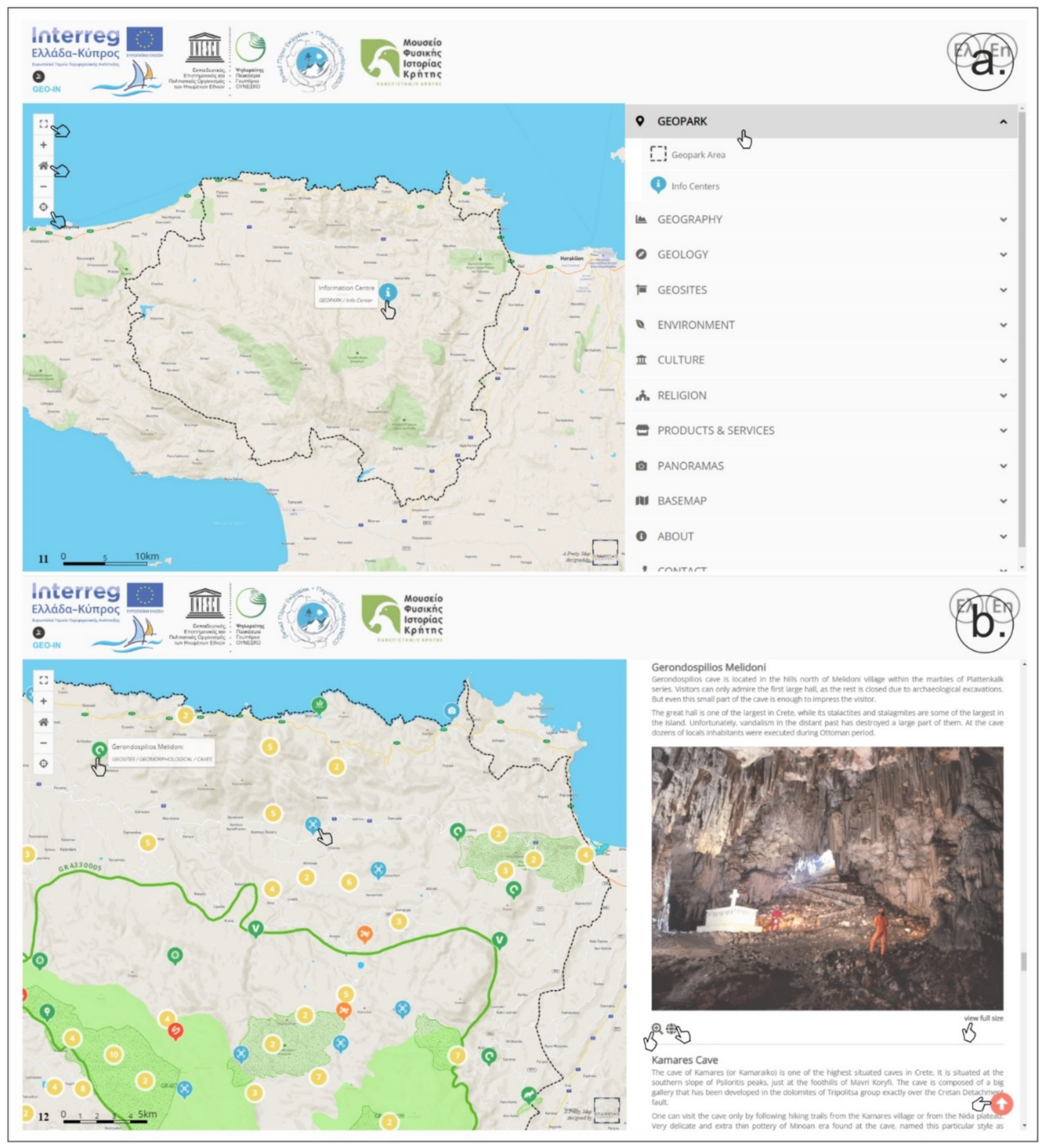
The interactive digital map of Psiloritis UGGp can be regarded as an online book with interactive chapters, presenting a strong spatial reference (https://tours.nhmc.uoc.gr/geo/psiloritis/, accessed on 28 December 2021). It was initially developed as a web map by the Natural History Museum of Crete, together with a similar map for Sitia UGGp under GEO-IN project [61], and was further expanded and enriched under the current RURITAGE project to benefit the sustainable development of Psiloritis. It features two interconnected areas, the map area itself, and the side panel area (Figure 3). On the side panel, the menu (chapters and subchapters) is presented in “accordion” mode. By clicking on any topic, it expands the chapter relevant to that topic, and at the same time spatial data are added on the map. The map area covers the largest part of the screen and provides tools for zooming in/out, viewing in “full screen”, returning to the home page or geolocating a user (if the user is in a field with a mobile device) (Figure 3a). The map has eighteen zoom levels, from the global scale (global map) to the local scale up to 1:2500, and always displays a scale bar. As the reader scrolls and reads or clicks on information in the side panel, the map pans and zooms, facilitating the display of the spatial context of the information. Additionally, in reverse, when clicking a feature on the map, it scrolls automatically through the side panel until the relevant information reaches the top of the page (Figure 3b).
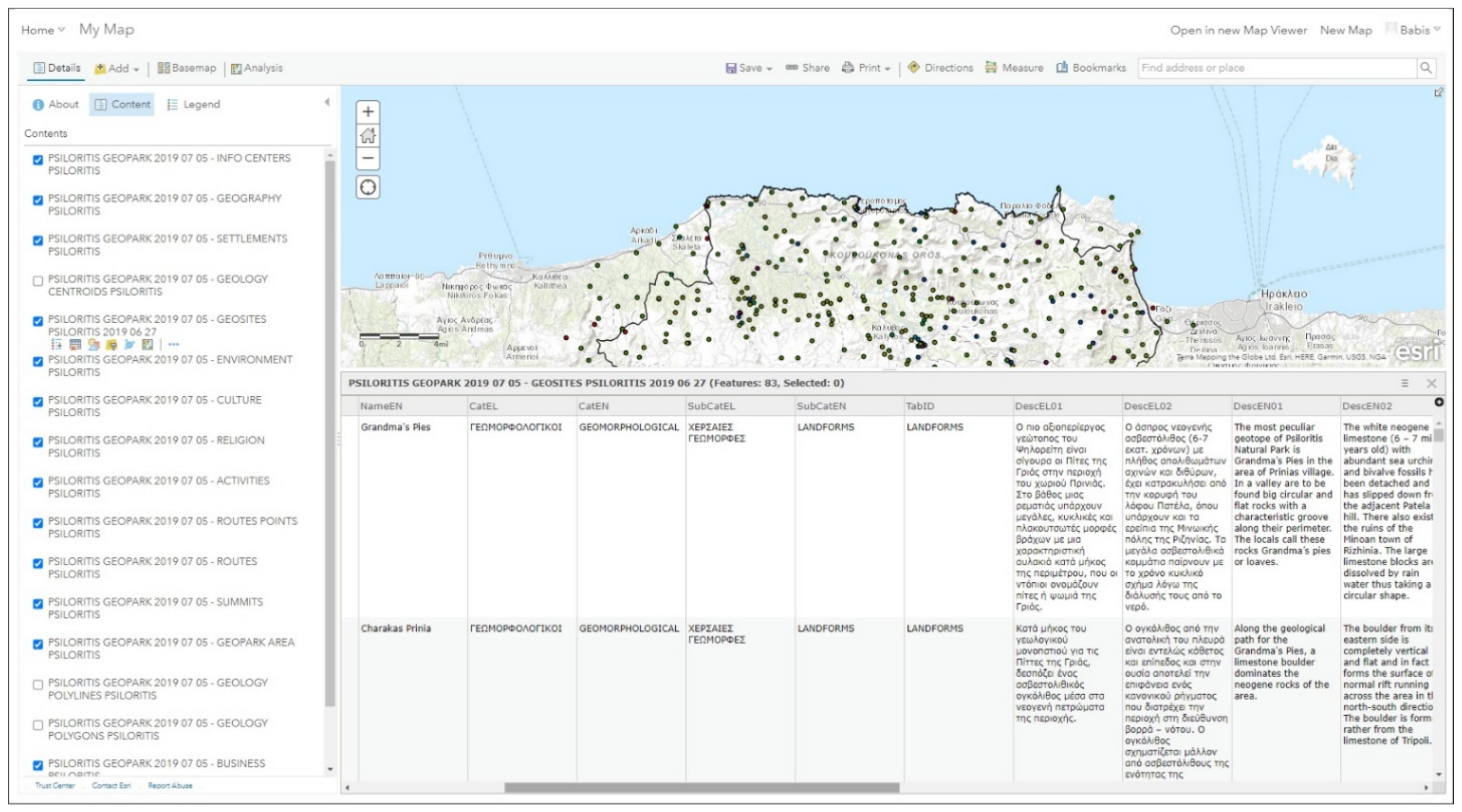
The map has been developed with the Leaflet.js API that uses “feature” and “tile layers” from the ArcGIS Online account of the Natural History Museum of Crete. Since it is data-centered, all data were collected in a uniform geodatabase (Figure 4), and analyzed in ArcGIS Pro. The geodatabase was initially developed for the geoheritage assessment and geoconservation [57,58], and later on, during the GEOIN project implementation, was updated to incorporate geointerpretation and geotourism. At present, the geodatabase hosts information and documentation of geoheritage and all natural, cultural and economic values of the geopark; it is best regarded as an information depository. The geodatabase includes previously established information on the Psiloritis geopark, and new information digitized during the GEO-IN or RURITAGE projects. The data are separated into divisions: some are static (such as environmental and geological polygons) and some are dynamic (such as geosites, local businesses, cultural sites, etc.). Static data were uploaded to ArcGIS Online as “tile layers” to save storage and decrease loading time. Dynamic data were uploaded as “feature layers”, further edited in either ArcGIS Online or ArcGIS Pro. This offers a huge advantage as any new entry or correction can happen in real time (on both the server and user side). The maintenance team can easily perform updates, thus keeping the map alive!
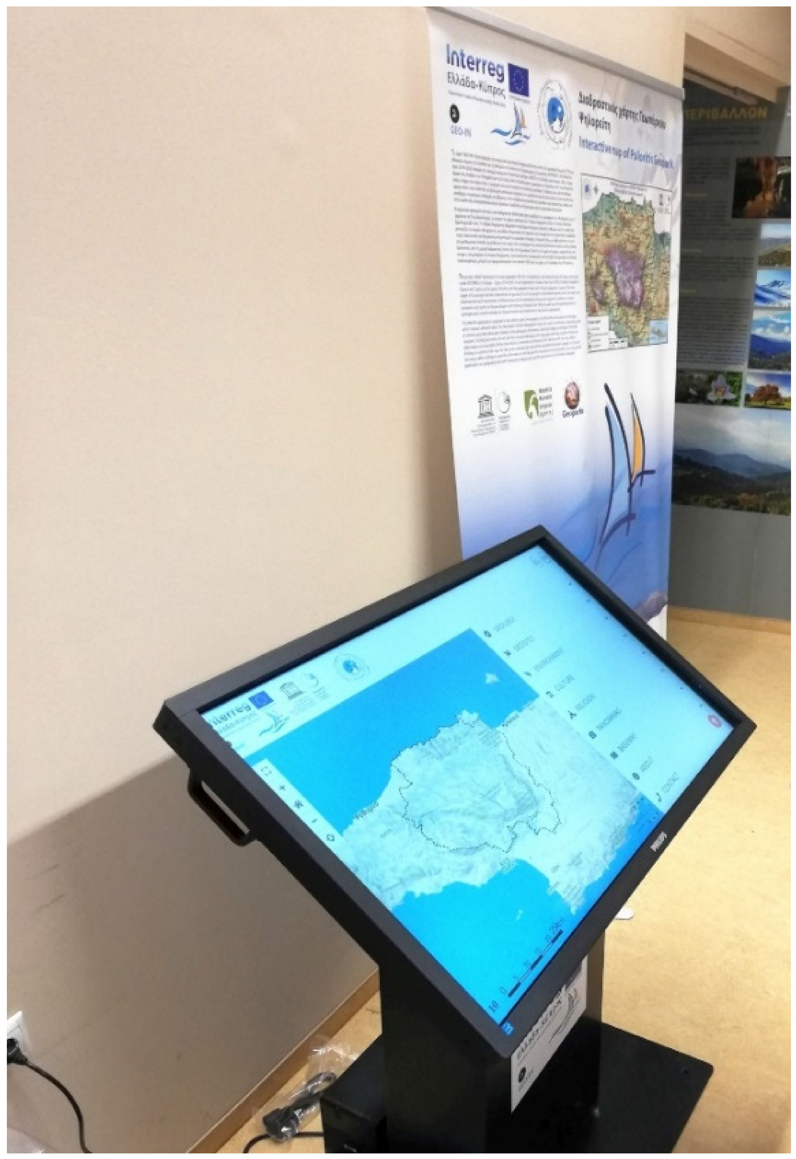
We emphasize the responsive design of this map application: it is compatible to the user’s device, either a PC, laptop, mobile, etc., and adapts to screen dimensions and orientation. The map includes a geolocation function on portable devices so that it can be used as a navigational tool when used in outdoor activities. While such navigational tools are not a new technology, we introduced the facility to click a geolocation button and immediately identify nearby sites of interest, discover other aspects of local heritage, find accommodation and food options, and, in real time, re-design the visit in the geopark. The map at present is bilingual (Greek and English). For communication purposes, the geopark developed three static information units, with touchscreens and personal computer monitors that permit visitors to museums or info centers to navigate through the app (Figure 5). At present, such units are located in our info center at Anogia, the exhibition of the Natural History Museum of Crete at Heraklion, and at the info kiosk of Meronas village at Amari.
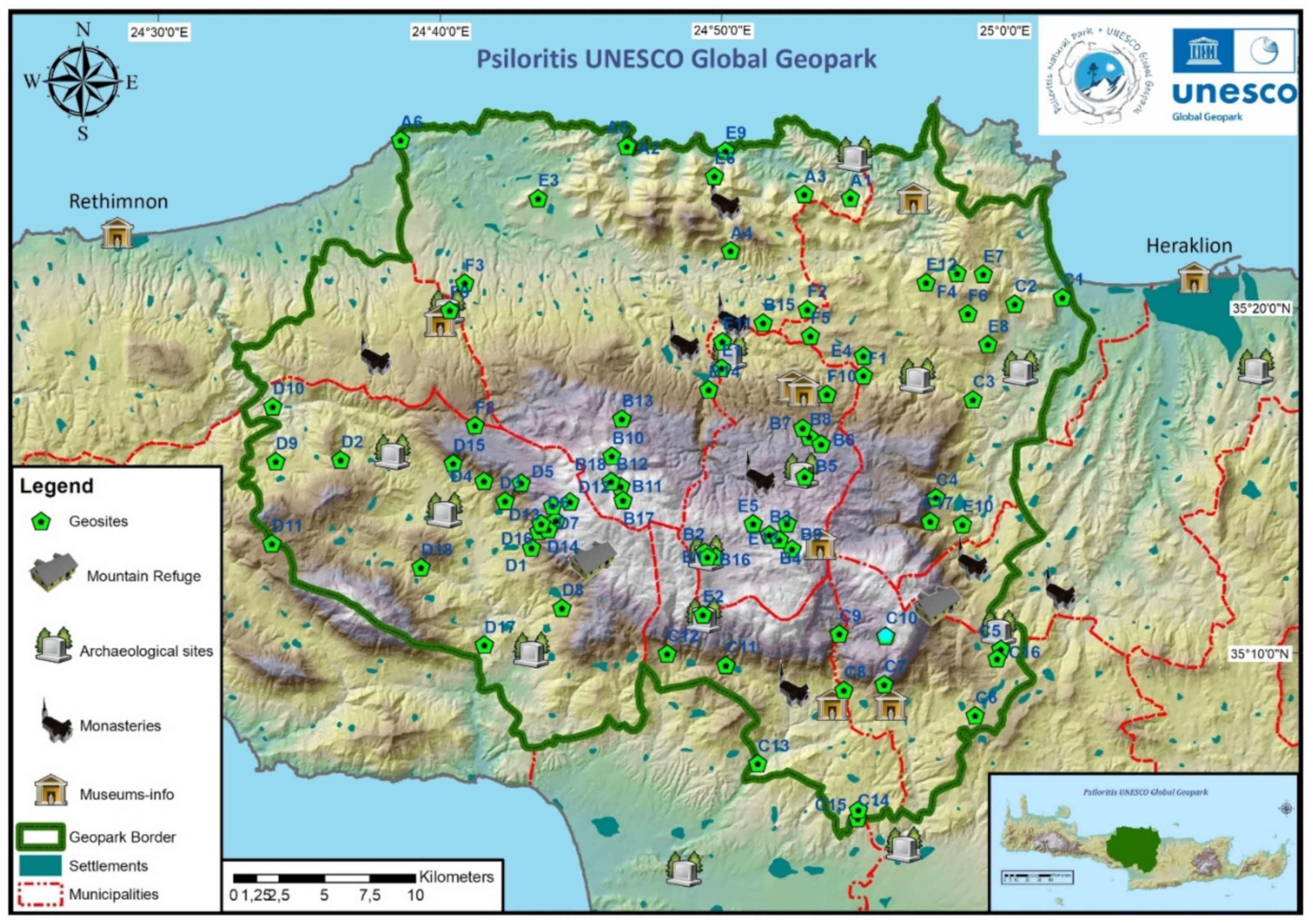
The topics that are presented on the map were carefully selected to display the natural and cultural values of Psiloritis, to promote territories within the geopark, and to enhance geotouristic aims. They include information on the local heritage, i.e., geography and geomorphology, the geological features and geosites, environmental and protected areas, and sites of cultural and religious significance. Corrections were made in available geological polygons and a whole new classification system for the geosites was established following the assessment of the geopark [58] and incorporating an international nomenclature [62]. Geosites are classified via geomorphological, petrological, tectonic, hydrogeological, paleontological, geocultural parameters. All heritage features are noted on the map and interpreted on the side panel using text or/and images that can be spotted on the map or shared via Google Maps. Various information levels can be combined and shown on the map panel.
A great asset of this digital application is a special menu featuring aerial- and ground-based 360° spherical panoramas that have been captured by drones and other sophisticated devices. Under the RURITAGE project, more than 130 panoramas were added. The location of each “capture” is on the map, and the user can watch a virtual tour by clicking and opening the information window. The map user has the ability to “jump” from one panorama to another and create his/her own virtual trip through the popup window or view it on a new window. At present, more than 400 panoramas have been produced for the geopark, and all can be shared free-of-charge by anyone via the relevant social media or websites.
A new feature of this map is its display of local enterprises participating in the “Quality Agreement” initiative (Figure 3b). These are listed under the chapter “Products and Services” that includes five categories: Accommodation, Local Cuisine, Local Products, Local art, and Alternative tourism. Twenty-eight producers, artists and service providers are promoted at this time. By clicking on the “Products & Services” chapter, all of them are presented on the map. Contact information for each partner is provided by clicking on the map or at the side area, as well as their equivalent entry on other business platforms, such as Google Maps. All data layers can be overlain and the user him/herself can combine various information on the map (Figure 3b). Using the geolocation tool and other base maps, the user can identify nearby heritage sites, villages, walking trails or any other information provided by terrain or satellite maps. This tool can be used for planning trips.

3.2. Story Maps

The idea behind story maps derives from the respective ESRI ArcGIS web “apps”, where spatial information depicted in one or more maps plays a significant role in how the information is presented to the user [63]. In the previous GEOIN project, web tools and templates provided by ESRI were used to build a “classic” story map [64], and create an individualized storytelling map for Psiloritis UGGp (https://tours.nhmc.uoc.gr/geoparks/map/idi/en/index.html, accessed on 28 December 2021). However, we found limitations when the map was based only on these “classic” story map features. Creating multiple story maps under the same domain, presenting them in the same thematic website, and translating them into different languages were accomplished by an alternative solution within the Wordpress websites. We then developed a Wordpress website (
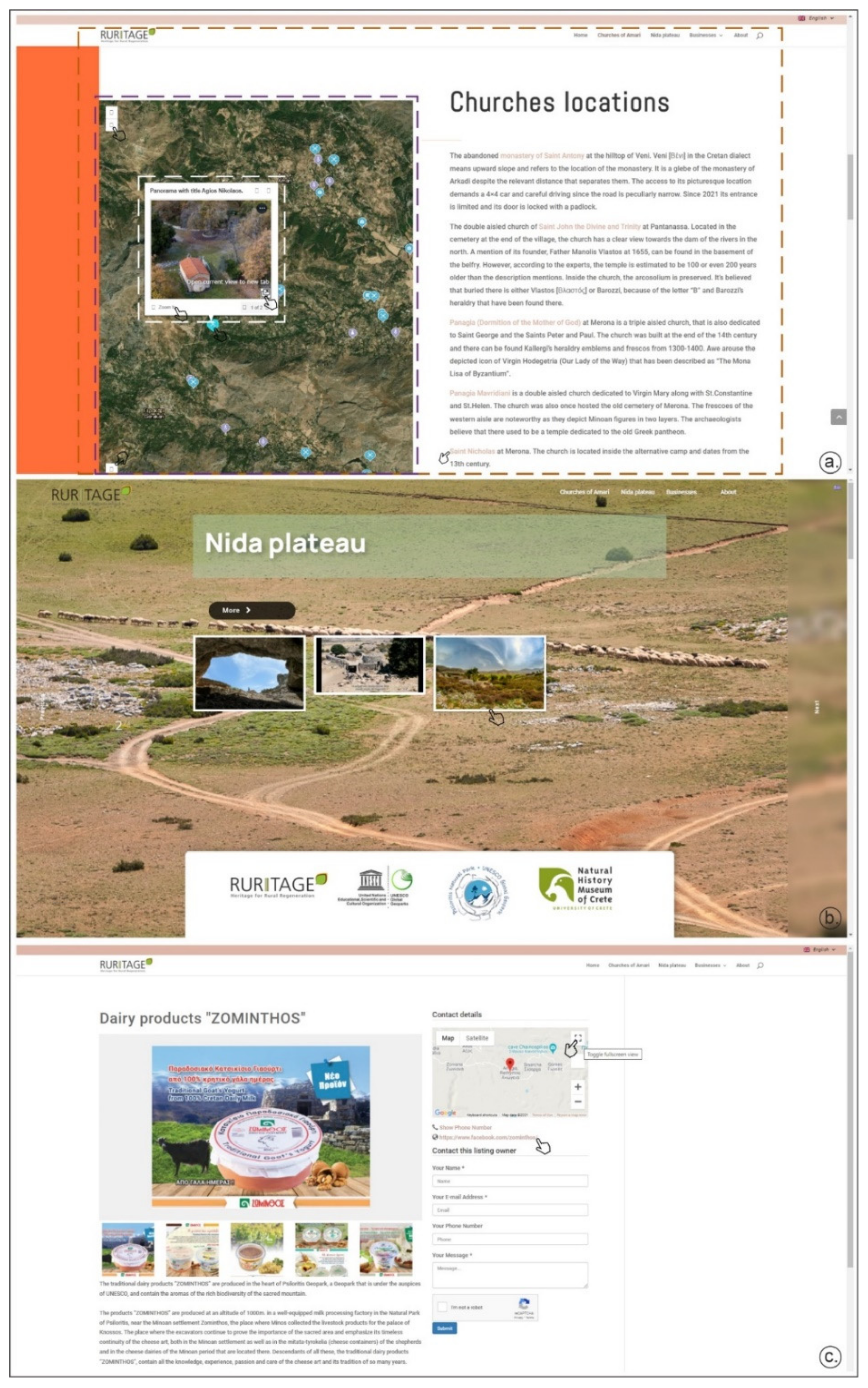
https://storymaps.nhmc.uoc.gr/, accessed on 28 December 2021) interlinked with the geopark’s website that hosted new thematic story maps and a business listing. We present thematic story maps that depict the historic churches of the Amari area and the geosites of Nida plateau. We also list the “Affiliated Businesses” who are participating in the “Quality agreement” of the geopark as an independent listing directory rather than a story map. The business listing directories are webpages providing information, that lists businesses within niche-based categories.
Our thematic webpages are an interconnection and interplay of three main standalone applications: the Wordpress webpage; the web maps; and the virtual tours (Figure 6). Several plugins of Wordpress applications host most of the textual information, photos and videos including galleries, carousels, and slideshows. The website itself connects the texts and the visual data, offering a unified environment for the user’s experience. The other two components (web maps and virtual tours) are embedded into it. The web maps were developed in ESRI ArcGIS JavaScript API 4.13 and the spatial data used in the maps are hosted in the Natural History Museum of the University of Crete ArcGIS Online Portal. These maps function as standalone web “apps” for the purposes of panning and zooming in and out. The virtual tours are HTML5 webpages that can be viewed as standalone web “apps” in browsers such as Chrome, Safari, Firefox, Edge, etc. The virtual tours are comprised of spherical photo panoramas that are shots from a specific location in the geopark. Most of these panoramas are aerial and allow a better view of the surrounding area. Virtual tours facilitate standalone embedded maps that include the locations of the panoramas and hotspots, and allow menu navigation from one panorama to another. Virtual tours provide supplementary visual information and interpretation by allowing the users to have control of what part of the photo they want to inspect. These virtual tours also have WebXR (https://www.w3.org/TR/webxr/, accessed on 28 December 2021) capabilities that allow the supporting browsers to be viewed in a Virtual Reality (VR) mode.
Links within the Wordpress webpage enable an interaction with the embedded web map and can cause it to focus on respective locations, while an information window (popup) appears that includes the title of the site (church, location, enterprise), and either a photo (in the Churches of Amari) or a panorama from the virtual tour (in the Nida plateau and some Churches at Amari). All three of these components present information by corresponding to the size of the device that is used to view the website. The Wordpress webpage approach offers the opportunity to add more story maps and integrate more information within them. Each webpage suggests trips that can be planned through integrating the interactive map.
The story map webpage for the Churches of Amari hosts information and images of thirty historic Christian churches, monasteries, and chapels dating back to the 7th century A.D. Amari is located in the southwestern part of the geopark (Figure 6a). It is an area of rich natural and cultural heritage popular with alternative tourists seeking birdwatching, botanical activities, hiking and climbing within the gorges of Platania, Patsos and Fourfouras, and trekking to the peak of Psiloritis.
The Nida plateau is one of the most important areas of the geopark, hosting a remarkable bio- and geodiversity, as well as valuable cultural assets. In the broader area of the plateau, five important geosites occur: the Idaion Andro and Kamares archaeological caves, with the first one being the most important sacred place from Neolithic to Roman times in Crete; the Cretan detachment fault; the Idaion active fault; and the Nida plateau itself. Several endemic species of local flora live in this area, as well as endangered and endemic fauna. The intangible heritage of the “Mitata” includes the stone buildings used by the shepherds. The customs and ethics of these shepherds are still extant, and their centuries of grazing activities dominate the plateau landscape. This heritage is shown on the Nida plateau story map webpage with a narration that focuses on a virtual tour along the plateau, also including the geomorphic sinkhole topography and the peaks of Mavri Korifi within an embedded interpretative map and a photo gallery (Figure 6b).
The third, the business listing webpage, hosts the Affiliated Businesses of the geopark (Figure 6c). Contact details and information regarding products and services enabled the allocation of businesses into six categories: “Local cuisine” with five tavernas and local restaurants; “Alternative tourism” with eight travel agencies or tourism service providers offering accommodation and eco-touristic activities; “Accommodation” with ten local resorts, hotels, villas or studios; “Local products” with nine producers of local goods (such as honey, dairy, cookies, wine, or olive products); and “Local art” with three local artists and their pottery, wood-carving or glass workshops. The enterprises are presented through an embedded map but also through individual webpages that include descriptions and contact information for the enterprise, an embedded map, direct contact tools and photo or/and video gallery.
All three of these webpages are linked with the interactive map of the geopark, increasing the accessibility of the knowledge base of natural and cultural heritage, and the products and experiences offered. This link is found under the “prompt” that leads to planning a trip through the geopark of Psiloritis.

3.3. The Virtual Reality Tour

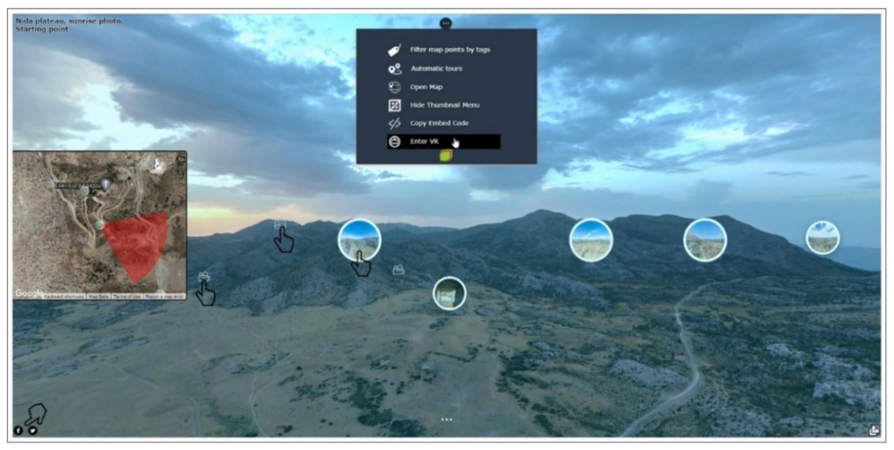
We have created a Virtual Reality (VR) tour for the Nida plateau area that is a “stand-alone” product (https://tours.nhmc.uoc.gr/geoparks/nida/, accessed on 28 December 2021). Since this uses locally stored files, there are no internet bandwidth limitations, and so it can reproduce super-high-definition (SHD) 360° panoramic videos. This VR tour was designed to further exploit these 360° panoramas and enrich the user’s experience via WebXR capabilities that allow web browsers of mobile devices and special VR equipment to view the panorama in a virtual reality. The tour is composed of nineteen SHD aerial and ground spherical panoramic videos that cover the whole plateau and its surrounding areas, offering shots even from inside the Idaion Andro cave, as well as embedded maps, videos, images, and text information (Figure 7). Narrations including interpretations of the Cretan detachment fault and the Idaion fault geosites [65,66]; videos and panoramas on the social life of shepherds, and a large number of images are offered to the users.
Devices that support WebXR (VR mode) include most modern mobile phones and VR headsets. In the VR mode of mobile devices, the screen splits into two parts, one for each eye, and the WebXR-enabled device controls the area that is visible to the user by detecting motion and the angle of view. As the device turns (e.g., with the head movement) the angle of view of the virtual tour changes accordingly. In order to view the Virtual Reality tour properly on a mobile phone that supports WebXR, an inexpensive VR Cardboard headset is required. However, using this headset limits VR capabilities, and the interface is stripped of all the virtual tour components, except the hotspots that change the location (spherical photographic panoramas) of the virtual tour. By using more complex commercial VR headsets, the virtual tour can be either viewed as a normal website, or in its WebXR/VR mode. This provides all the benefits of VR technology such as 3D view, spotting and enabling videos, images, narrations, site interpretations and jumping from one panorama to another.
Two commercial headsets were purchased to be used by the visitors to the geopark’s info center at Anogia, and the Natural History Museum of Crete at Heraklion.

3.4. Applications’ Use during COVID-19 Times

During the COVID-19 pandemic these digital “apps” were applied in the Psiloritis geopark through several opportunities and campaigns. Soon after the first global lockdown in spring 2020, the geopark joined the campaign of the European Geoparks Network [3], promoting geoparks as “Territories of Resilience”, and supporting the Hellenic Geoparks Forum initiative “Experience with safety natural and cultural monuments” [
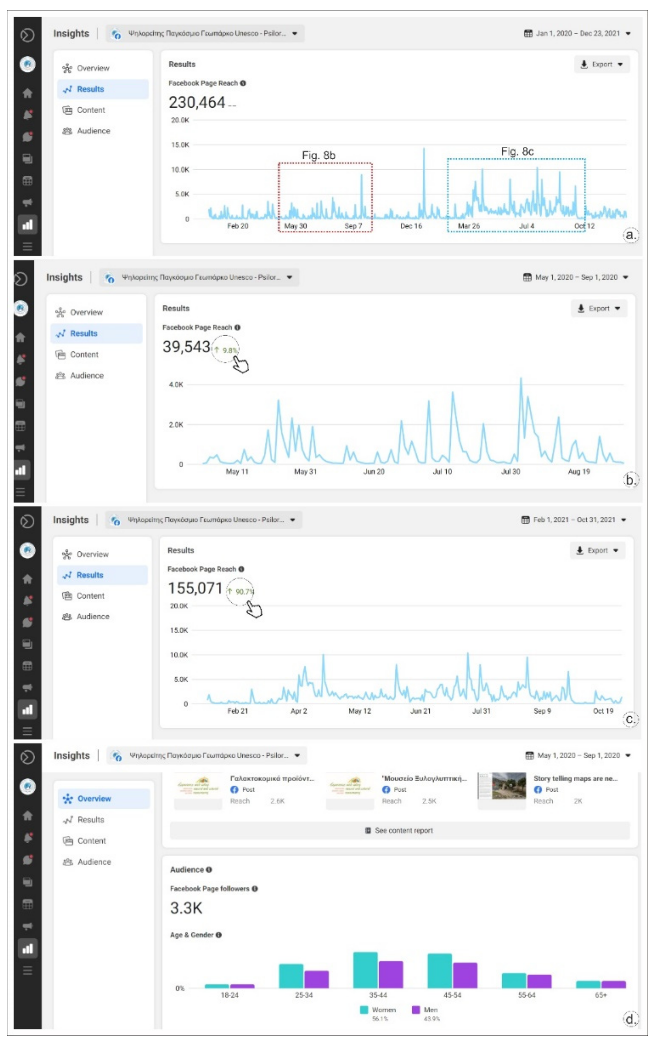
67]. From May to September 2020, Psiloritis started the promotion of affiliated partners through social media, dedicating one post to each partner. This campaign was enthusiastically accepted by the geopark’s followers and stakeholders, as well as by the affiliated enterprises that shared posts in large numbers. Statistics (Figure 8a,b) indicate that posts related to enterprise promotion (depicted as characteristic peaks on the relative graph) received many more views than the ordinary posts of the geopark. This campaign added more visitors to the official webpage of geopark (through the followers of the enterprises) and strengthened the connections of enterprises with the geopark during the economically challenging times of the pandemic. With satisfying parts of the “Enhancement Plan” and the celebration of the 20th anniversary of Psiloritis geopark, a new social media campaign was launched in February 2021 that lasted through October of the same year. The statistics of posts (Figure 8c) show a considerable increase in views as an overall increase of up to 90%. Specific peaks can be identified with the posts promoting local enterprises, specific landscapes and geosites or the introduction of the new “apps” (Figure 8d). These statistics demonstrate (Figure 8d) that the geopark’s audience is within the “economically active” ages: mainly 25–34, 35–44 (the highest demographic) and 45–54 groups. Most of this audience is women (56.1% compared to 43.9% men).
It is still too early to fully assess the contribution of these digital tools within the sustainable development of the geopark and the local economy, but we can show that these digital “apps” increased the visibility of our territory, enhanced the understanding and appreciation of our natural and cultural heritage, enriched the products and experiences that our visitors (potential and actual) and inhabitants can enjoy, and supported our local enterprises and products, strengthening their bonds with the geopark. We hope that through continuing the promotion and sharing of these digital “apps”, the completion of the “Enhancement Plan” and following the return to “normal”, post pandemic life, we will be able to process the direct impact on geotourism and local income that these “apps” provide.

4. Discussion and Conclusions

Digital tools such as web-based maps, 360° panoramas, storytelling maps, and virtual reality environments are continuously evolving. Regarding their use in geoparks, these tools promote many activities related to geoheritage mapping, geolocation, geovisualization, geointerpretation and geotourism [4]. During the past decade, unmanned aerial vehicles (drones), multimedia, and VR technologies have facilitated the promotion and interpretation of geodiversity [68]. These technological “apps” utilize the knowledge base of the existing infrastructure of geoparks derived from geosite inventories, geologic interpretation, trails, and info centers. They are accessible in situ and indoor as web-accessible localities, and are available during and out of tourism seasons. Ólafsdóttir and Tverijonaite [46] point out that the majority of these tools, as described in the literature, do not always cover the needs of geotourism stakeholders within the context of sustainable development. To date, most uses of these tools do not consider their beneficial impact on individuals, either as consumers (visitors) or producers (locals), within the promotion of digital sustainability [19], which is one of the main targets of the UNESCO Global Geoparks. Psiloritis Geopark has exploited and expanded the capabilities of these digital tools: we developed new and innovative applications to support our stakeholders and to offer holistic, inclusive and integrated experiences to our on-site and “web” visitors.
A UNESCO Global Geopark is a complex body with diverse components (local heritage and stakeholders) and multiple tasks to complete. These components act analogously to the gears of a well-set engine to aid the geopark in reaching its targets [29]. Psiloritis is composed of interworking features with a great and imposing geodiversity, profound living environment, well-known and famous culture and human history, as well as scattered human activities. Located in one of the most touristic islands of Greece and the Mediterranean it faces the goal of the responsible development of geotouristic activities in an economically challenged region. A natural environment that is healthy and left intact by tourism and human pressures, a long-lasting history and culture, and the superb quality of agricultural and livestock products are considered strong merits of the territory [59]. The geopark has undertaken the responsibility to coordinate local groups, develop actions and synergies, promote local products and services, and build geotouristic initiatives. Based on these activities it has successfully been evaluated by the GGN and UNESCO several times during the twenty years of its existence.
The challenges imposed by the COVID-19 pandemic and the climate crisis require the flexibility and adaptation of geoparks to the new social, environmental and economic conditions. As stated at the “World After roadmap” [2], it is crucial for UGGps to focus on services in addition to geointerpretation and geotourism. In this way, geoparks can cope with the needs of citizens and visitors, improve the resilience of the society and mitigate various risks. Education and raising awareness can aid the general public’s understanding of our fragile planet. The creation of new digital tools can help to meet these needs, even in cases of the recent pandemic, and should be the goals of UGGps according to the “Top 10 Focus Areas” [2,43]. It is apparent that the new digital applications developed by the Psiloritis geopark contribute significantly to achieving the goals of the “Top 10 Focus Areas”: digital tools promote geological and broader natural landscapes of Psiloritis, encompass new scientific methodologies and technological achievements, inform and educate visitors and inhabitants on the values of the territory, contribute to sustainable development by enforcing geo and sustainable tourism, and are inclusive and integrated. They help to raise awareness of the natural risks and the need for geoconservation. Digital applications are also compatible with the provisions of the “World After roadmap” with respect to the need to raise awareness of natural risks and adapt to our challenging future.
The new applications come as a result of the implementation of the “Enhancement Plan” for Psiloritis geopark developed under the RURITAGE project. Although Psiloritis serves as a “Role Model” within RURITAGE, project implementation was impeded by the pandemic conditions and provided Psiloritis with the resources needed to develop its own regeneration and “Enhancement Plan”. These applications were developed under the first axis of the plan, which includes the “use of modern technologies (virtual maps, tours and VR) to enhance and promote the natural and cultural heritage of Psiloritis”. Less directly, they support the needs of the third axis to “strengthen local identity and pride based on the natural and cultural values of the area”. The interactive map through its chapters and subchapters, promotes the geological, natural, and cultural heritage of the geopark. The story maps for the Amari churches and the Nida plateau, and the VR tour at the Nida area connect the natural landscapes with the cultural environment and human resources. This combination is a new touristic product easily accessed and shared. The new applications support local products, artefacts and services via an interactive map and the webpage for the “Affiliated Enterprises” of the geopark, thus contributing to the promotion of the area and the local economic development. We can now claim that these products are in agreement with the provision of the “Enhancement Plan” to promote local heritage and goods and transform them into a strong and recognizable development tool that will raise local pride and improve the well-being of residents and visitors. The new products fit the basic tenet that a geopark should represent territories “built by people and for people” [2].
As UNESCO has denoted, geoparks contribute to several SDGs and most profoundly to SDGs 1, 4, 5, 8, 11, 12, 13 and 17. Following SDGs indicators [69], our new applications contribute directly or indirectly to the achievement of these goals. For SDG 1, the applications communicate information on geohazards existing in geopark, thus improving the knowledge level and resilience of the local populations. These digital promotions aid in the designation of local products that can help in critical situations such as pandemics. All applications can be used for lifelong learning, training, and education, and are offered to all free-of-charge, even for disabled people and those unable to travel; thus, they are inclusive, integrated, and equal according to SDG 4. These easily accessible applications grant access to knowledge and information, promote the collaborations of women through “coops” and similar initiatives in the territory, thus promoting the gender equality and female empowerment foreseen under SDG 5. These applications provide powerful, inclusive and innovative geotouristic tools that support, through sustainable tourism development, small- and medium-scale local businesses, their products and their services for the benefit of visitors and inhabitants. Therefore, their support of SDG 8 is very profound. In addition, by providing access to all geological, natural, and cultural values of the territory of Psiloritis, and highlighting the special relations between urban and rural areas, the “apps” contribute to making cities and settlements more safe, resilient, and sustainable, as SDG 11 addresses. The webpage for the “Affiliated Enterprises” and the interactive map promote local products and their consumption in a sustainable manner, as SDG 12 foresees. Similarly, these tools contribute to SDG 13 in the fight against the climate crisis by minimizing long-distance trading, product transportation (considering the islandic nature of Crete), and supporting traditional cultivation and livestock farming practices.
As these digital applications were developed only for Psiloritis UGGp, their impact on the achievement of SDG 17 may be regarded as insignificant. However, the “apps” are outcomes of an international project consortium and they will be shared to more than thirty-eight partners. These tools in our opinion, aid the initiation of a global partnership in support of sustainable development. In addition to the SDGs denoted by UNESCO for the UGGps, these “apps” follow the guidelines recommended by SDG 9 by promoting the development of local infrastructures and networks that are resilient, reliable, and sustainable (as they are easily updated, enriched and maintained), and simultaneously support local well-being and equitable access for all. These applications promote the use of scientific research and upgrade the technological capabilities of small- and medium-scale local enterprises of Psiloritis, facilitating free access to information and communication, as described under SDG 9.5. Finally, these “apps” aid in the promotion, interpretation, and recognition of the value of terrestrial ecosystems and landscapes, and increase the local appreciation and pride. In addition, they make conservation efforts more effective and easier to facilitate, thus helping local managers to achieve the sustainable management of ecosystems, reverse land degradation and halt biodiversity loss, as foreseen under SDG 15.
Based on these facts, we can assert that the new “apps” of Psiloritis UGGp reduce the existing gap [46] between the scientific achievements in the topics of geomapping, geolocation and geomodeling with the real needs of local people and tourists, allowing them to experience the sense of landscape and cultural ecosystem services via modern technology and devices [47]. Geotourism can now be considered a powerful tool for local managers to support geologic and nature conservation; visitors and inhabitants become aware of their surrounding environment, appreciate its value and the need for its maintenance, and can participate in landscape and heritage management without conflicting with the needs of local development.
In summary, the new digital applications that were developed by Psiloritis UGGp under the implementation of the RURITAGE “Enhancement Plan” enrich the existing interactive geopark map, add new story maps of the geopark and a business listing of “Affiliated Enterprises”, and provide a virtual reality tour of the Nida area. These tools for the geopark are based on modern technologies for geolocation, geovisualization and geointerpretation, and promote the natural and cultural heritage of Psiloritis and their interconnections and interrelations with human society. The tools support thematic tourism on the topics of religious sites and geology, as well as regional cuisine and local products. Webmaps, 360° spherical panoramas and virtual tours are incorporated into the interactive map and the Wordpress webpages, and include videos, narratives, images and site interpretation. The Nida website offers WEBXR features to support its virtual reality tour.
As with most digital applications, our maps are accessible free-of-charge by all web browsers. They provide access to information and data for all those who are interested and are especially helpful to those who are unable to visit the geopark, including people with special mobility needs. These “apps” are device-customized to provide an optimum performance in all desktop and mobile devices and are bilingual. To be consistent with the principles of digital sustainable development, the “apps” link all natural, cultural and human values in the Psiloritis territory for geo and Earth scientists, as well as the general public, visitors and inhabitants. These new diversified digital products combine older applications and geopark experiences with new concepts that connect the landscape’s spirit with the thousands of years of human culture in the area.
These new tools are in compliance with the “Top 10 Focus Areas” of the UGGps, and meet most provisions of the “World After roadmap”, as suggested by the GGN. Directly or indirectly, these digital tools support the achievement of the eight SDGs denoted by UNESCO for UGGps, as well as SDGs 9 and 15. The promotion of these tools through the geopark’s webpage and social media during the two years of the COVID-19 pandemic demonstrated their great acceptance by the public and their significant contribution in raising the residents’ and visitor’s awareness of the local heritage. The regional and global visibility of the geopark was maintained and advanced further. Through geotourism, these new digital tools are expected to contribute significantly to the post pandemic regeneration and local sustainable development of Psiloritis UGGp.

Author Contributions

Conceptualization, C.F.; methodology, C.F., E.N. and S.S.; interactive map development, S.S. and C.F.; digitization, E.N.; app development, S.S., E.N. and C.F.; writing—original draft preparation, C.F.; writing—review and editing, C.F., E.N. and S.S.; supervision, C.F. All authors have read and agreed to the published version of the manuscript.

Funding

C.F. and E.N. have received funding from the European Union’s Horizon 2020 Research and Innovation Programme, RURITAGE project, grant agreement no. 776465. The contents reflect only the authors’ views, and the European Union is not liable for any use that may be made of the information contained therein.

Institutional Review Board Statement

Not applicable.

Informed Consent Statement

Not applicable.

Data Availability Statement

No new data were created or analyzed in this study. Data sharing is not applicable to this article.

Acknowledgments

We wish to thank AKOMM PSILORITIS SA and its director, Dimitrios Pattakos, who developed, undertook, and coordinated several initiatives for Psiloritis UGGp, such as the “Local Quality Agreement” and GEO-IN project. We are grateful to Anne Ewing Rassios for correcting the English text. Three anonymous reviewers are also thanked for their critical and helpful comments.

Conflicts of Interest

The authors declare no conflict of interest.

References

  1. Yang, Y.; Altschuler, B.; Liang, Z.; Li, X. (Robert) Monitoring the global COVID-19 impact on tourism: The COVID-19 tourism index. Ann. Tour. Res. 2021, 90, 103120. [Google Scholar] [CrossRef] [PubMed]
  2. Martini, B.G.; Zouros, N.; Zhang, J.; Jin, X.; Komoo, I.; Border, M.; Watanabe, M.; Frey, M.L.; Rangnes, K.; Van, T.T.; et al. UNESCO Global Geoparks in the “World after”: A multiple-goals roadmap proposal for future discussion. Episodes 2021. [Google Scholar] [CrossRef] [PubMed]
  3. EGN. European Geoparks Network, EGN Magazine 2021, 18. Available online: http://www.europeangeoparks.org/?page_id=395 (accessed on 28 December 2021).
  4. Cayla, N. An Overview of New Technologies Applied to the Management of Geoheritage. Geoheritage 2014, 6, 91–102. [Google Scholar] [CrossRef]
  5. Hoblea, F.; Delannoy, J.-J.; Jaillet, S.; Ployon, E.; Sadier, B. Digital Tools for Managing and Promoting Karst Geosites in Southeast France. Geoheritage 2014, 6, 113–127. [Google Scholar] [CrossRef]
  6. Gentilini, S.; Thjømøe, P.; Birkenes, M. Responsible use of natural and cultural heritage. In Proceedings of the 13th International Geoparks Congress, Rokua Geopark, Finland, 3–6 September 2015; Available online: http://www.europeangeoparks.org/wp-content/uploads/2012/02/Book-of-Abstracts-EGN-conference-2015.pdf (accessed on 28 December 2021).
  7. Perotti, L.; Bollati, I.M.; Viani, C.; Zanoletti, E.; Caironi, V.; Pelfini, M.; Giardino, M. Fieldtrips and Virtual Tours as Geotourism Resources: Examples from the Sesia Val Grande UNESCO Global Geopark (NW Italy). Resources 2020, 9, 63. [Google Scholar] [CrossRef]
  8. Gambino, F.; Borghi, A.; D’Atri, A.; Gallo, L.M.; Ghiraldi, L.; Giardino, M.; Martire, L.; Palomba, M.; Perotti, L.; Macadam, J. TOURinSTONES: A Free Mobile Application for Promoting Geological Heritage in the City of Torino (NW Italy). Geoheritage 2019, 11, 3–17. [Google Scholar] [CrossRef]
  9. Pica, A.; Reynard, E.; Grangier, L.; Kaise, K.; Ghiraldi, L.; Perotti, L.; Del Monte, M. GeoGuides, Urban Geotourism Offer Powered by Mobile Application Technology. Geoheritage 2018, 10, 311–326. [Google Scholar] [CrossRef]
  10. Aldighieri, B.; Testa, B.; Bertini, A. 3D Exploration of the San Lucano Valley: Virtual Geo-routes for Everyone Who Would Like to Understand the Landscape of the Dolomites. Geoheritage 2016, 8, 77–90. [Google Scholar] [CrossRef]
  11. Alfonso, J.L.M.; Piedrabuena, M.; Ángel, P.; Bergua, S.B.; Arenas, D.H. Geotourism Itineraries and Augmented Reality in the Geomorphosites of the Arribes del Duero Natural Park (Zamora Sector, Spain). Geoheritage 2021, 13, 16. [Google Scholar] [CrossRef]
  12. Fassoulas, C.; Kefalogianni, Z.; Stathi, I.; Staridas, S. Interpreting cultural assets through traditional and innovative educational tools: The case of Mygia trail at Psiloritis Geopark. In Proceedings of the 15th Conference of European Geoparks, Sierra Norte Sevilla, Spain, 25–27 September 2019; p. 55. [Google Scholar]
  13. Kim, H.-S.; Lim, C. Developing a geologic 3D panoramic virtual geological field trip for Mudeung UNESCO global geopark, South Korea. Episodes 2019, 42, 235–244. [Google Scholar] [CrossRef] [Green Version]
  14. Li, Q.; Tian, M.; Li, X.; Shi, Y.; Zhou, X. Toward smartphone applications for geoparks information and interpretation systems in China. Open Geosci. 2015, 7, 663–677. [Google Scholar] [CrossRef]
  15. Kurzweil, R. The Law of Accelerating Returns. In Alan Turing: Life and Legacy of a Great Thinker; Springer International Publishing: Berlin/Heidelberg, Germany, 2004; pp. 381–416. [Google Scholar] [CrossRef]
  16. UN. United Nations, Transforming our World: The 2030 Agenda for Sustainable Development. 2015. Available online: https://en.unesco.org/global-geoparks/focus#sdg (accessed on 28 December 2021).
  17. George, G.; Merrill, R.K.; Schillebeeckx, S.J.D. Digital Sustainability and Entrepreneurship: How Digital Innovations Are Helping Tackle Climate Change and Sustainable Development. Entrep. Theory Pract. 2020, 45, 999–1027. [Google Scholar] [CrossRef] [Green Version]
  18. Pulsiri, N.; Vatananan-Thesenvitz, R.; Tantipisitkul, K.; Aung, T.H.; Schaller, A.-A.; Schaller, A.-M.; Methananthakul, K.; Shannon, R. Achieving Sustainable Development Goals for people with disabilities through digital technologies. In Proceedings of the Achieving Sustainable Development Goals for People with Disabilities through Digital Technologies, Portland International Conference on Management of Engineering and Technology (PICMET), Portland, OR, USA, 25–29 August 2019; pp. 1–10. [Google Scholar] [CrossRef]
  19. Sparviero, S.; Ragnedda, M. Towards digital sustainability: The long journey to the sustainable development goals 2030. Digit. Policy Regul. Gov. 2021, 23, 216–228. [Google Scholar] [CrossRef]
  20. Quesada-Román, A.; Torres-Bernhard, L.; Ruiz-Álvarez, M.A.; Rodríguez-Maradiaga, M.; Velázquez-Espinoza, G.; Espinosa-Vega, C.; Toral, J.; Rodríguez-Bolaños, H. Geodiversity, Geoconservation, and Geotourism in Central America. Land 2021, 11, 48. [Google Scholar] [CrossRef]
  21. Williams, M.; McHenry, M. The increasing need for Geographical Information Technology (GIT) tools in Geoconservation and Geotourism. Geoconserv. Res. 2020, 3, 17–32. [Google Scholar] [CrossRef]
  22. McKeever, P.J.; Zouros, N. Geoparks: Celebrating Earth heritage, sustaining local communities. Episodes 2005, 28, 274–278. [Google Scholar]
  23. UNESCO. UNESCO Global Geoparks, Celebrating Earth Heritage, Sustaining local Communities. 2016. Available online: https://unesdoc.unesco.org/ark:/48223/pf0000243650 (accessed on 28 December 2021).
  24. UNESCO. UNESCO Global Geoparks & Sustainable Development. Geoparks Fundamental Features, Our Commitment to the Sustainable Development Goals. 2021. Available online: https://en.unesco.org/global-geoparks/focus#sdg (accessed on 28 December 2021).
  25. Silva, E.M.R. The Contribution of the European UNESCO Global Geoparks for the 2030 Agenda for Sustainable Development—A Study Based On Several Data Sources. Ph.D. Thesis, Universitade Nova, Lisbon, Portugal, 2021. Available online: http://hdl.handle.net/10362/114994 (accessed on 28 December 2021).
  26. Catana, M.M.; Brilha, J.B. The Role of UNESCO Global Geoparks in Promoting Geosciences Education for Sustainability. Geoheritage 2020, 12, 1. [Google Scholar] [CrossRef]
  27. Duarte, A.; Braga, V.; Marques, C.; Sá, A.A. Geotourism and Territorial Development: A Systematic Literature Review and Research Agenda. Geoheritage 2020, 12, 65. [Google Scholar] [CrossRef]
  28. Fassoulas, C.; Watanabe, M.; Pavlova, I.; Amorfini, A.; Dellarole, E.; Dierickx, F. UNESCO Global Geoparks: Living Laboratories to Mitigate Natural Induced Disasters and Strengthen Communities’ Resilience. In Natural Hazards and Disaster Risk Reduction, Geographies of the Anthropocene Series Book; Antronico, L., Marincioni, F., Eds.; Il Sileno Edizioni: Rende, Italy, 2018; pp. 175–197. [Google Scholar]
  29. Frey, M.-L. Geotourism—Examining Tools for Sustainable Development. Geoscience 2021, 11, 30. [Google Scholar] [CrossRef]
  30. Justice, S.C. UNESCO Global Geoparks, Geotourism and Communication of the Earth Sciences: A Case Study in the Chablais UNESCO Global Geopark, France. Geoscience 2018, 8, 149. [Google Scholar] [CrossRef] [Green Version]
  31. Pásková, M. Can Indigenous Knowledge Contribute to the Sustainability Management of the Aspiring Rio Coco Geopark, Nicaragua? Geosciences 2018, 8, 277. [Google Scholar] [CrossRef] [Green Version]
  32. Quesada-Román, A.; Pérez-Umaña, D. State of the Art of Geodiversity, Geoconservation, and Geotourism in Costa Rica. Geoscience 2020, 10, 211. [Google Scholar] [CrossRef]
  33. Quesada-Román, A.; Pérez-Umaña, D. Tropical Paleoglacial Geoheritage Inventory for Geotourism Management of Chirripó National Park, Costa Rica. Geoheritage 2020, 12, 58. [Google Scholar] [CrossRef]
  34. Rosado-González, E.M.; Sá, A.A.; Palacio-Prieto, J.L. UNESCO Global Geoparks in Latin America and the Caribbean, and Their Contribution to Agenda 2030 Sustainable Development Goals. Geoheritage 2020, 12, 36. [Google Scholar] [CrossRef]
  35. Pérez-Umaña, D.; Quesada-Román, A.; Tefogoum, G.Z. Geomorphological heritage inventory of Irazú Volcano, Costa Rica. Int. J. Geoheritage Park. 2020, 8, 31–47. [Google Scholar] [CrossRef]
  36. Silva, E.; Sá, A.A. Educational challenges in the Portuguese UNESCO Global Geoparks: Contributing for the implementation of the SDG 4. Int. J. Geoheritage Park. 2018, 6, 95–106. [Google Scholar] [CrossRef]
  37. Tefogoum, G.Z.; Román, A.Q.; Umaña, D.P. Geomorphosites inventory in the Eboga Volcano (Cameroon): Contribution for geotourism promotion. Géomorphologie Relief Processus Environ. 2020, 26, 19–33. [Google Scholar] [CrossRef] [Green Version]
  38. UNESCO. Statutes of the International Geoscience and Geoparks Programme (IGGP). 2015. Available online: https://unesdoc.unesco.org/ark:/48223/pf0000234539.locale=en (accessed on 28 December 2021).
  39. UNESCO. Geoparks Fundamental Features. 2021. Available online: https://en.unesco.org/global-geoparks/focus#fundamental (accessed on 28 December 2021).
  40. Zouros, N. Global Geoparks Network and the New Unesco Global Geoparks Programme. Bull. Geol. Soc. Greece 2017, 50, 284–292. [Google Scholar] [CrossRef] [Green Version]
  41. Zouros, N.; Rangnes, K. The European Geoparks Network: Operation and Procedures. Schriftenr. Dt. Ges. Geowiss. 2016, 88, 31–36. [Google Scholar] [CrossRef]
  42. Martini, G.; Zouros, N. Geoparks, a vision of the future. Geosciences 2008, 7, 182–189. [Google Scholar] [CrossRef]
  43. UNESCO. Top 10 Focus Areas of UNESCO Global Geoparks. 2021. Available online: https://en.unesco.org/global-geoparks/focus#focus (accessed on 28 December 2021).
  44. Farsani, N.T.; Coelho, C.; Costa, C. Geotourism and geoparks as novel strategies for socio-economic development in rural areas. Int. J. Tour. Res. 2011, 13, 68–81. [Google Scholar] [CrossRef]
  45. Herrera-Franco, G.; Montalván-Burbano, N.; Carrión-Mero, P.; Apolo-Masache, B.; Jaya-Montalvo, M. Research Trends in Geotourism: A Bibliometric Analysis Using the Scopus Database. Geoscience 2020, 10, 379. [Google Scholar] [CrossRef]
  46. Ólafsdóttir, R.; Tverijonaite, E. Geotourism: A Systematic Literature Review. Geoscience 2018, 8, 234. [Google Scholar] [CrossRef] [Green Version]
  47. Gordon, J.E. Geoheritage, Geotourism and the Cultural Landscape: Enhancing the Visitor Experience and Promoting Geoconservation. Geosciences 2018, 8, 136. [Google Scholar] [CrossRef] [Green Version]
  48. Hose, T.A. 3G’s for Modern Geotourism. Geoheritage 2012, 4, 7–24. [Google Scholar] [CrossRef]
  49. Newsome, D.; Dowling, R.K. Setting an agenda for geotourism. Geotour. Tour. Geol. Landsc. 2010, 1–12. [Google Scholar] [CrossRef]
  50. Dowling, R.K. Global Geotourism–An Emerging Form of Sustainable Tourism. Czech J. Tour. 2013, 2, 59–79. [Google Scholar] [CrossRef] [Green Version]
  51. National Geographic. Geotourism Principles. 2021. Available online: https://www.nationalgeographic.com/travel/article/geotourism-principles-1 (accessed on 28 December 2021).
  52. EGN. Arouca Declaration. In Proceedings of the International Congress of Geotourism, Arouca, Portugal, 9–13 November 2011; Available online: http://aroucageopark.pt/documents/78/Declaration_Arouca_EN.pdf (accessed on 28 December 2021).
  53. Stoffelen, A.; Vanneste, D. An integrative geotourism approach: Bridging conflicts in tourism landscape research. Tour. Geogr. 2015, 17, 544–560. [Google Scholar] [CrossRef]
  54. Vanneste, D.; Stoffelen, A. Integrating Natural and Cultural Heritage Assets for Tourism: A Critical Reflection on Bridging Concepts for Future Research; Edward Elgar Publishing: Groningen, The Netherlands, 2020; pp. 49–62. [Google Scholar]
  55. Fassoulas, C. Ρsiloritis Geopark: Protection of Geological Heritage Through Development. In Natural and Cultural Landscapes: The Geological Foundation; Parkes, M.A., Ed.; Royal Irish Academy: Dublin, Ireland, 2004; pp. 291–295. [Google Scholar]
  56. Fassoulas, C.; Zouros, N. Evaluating The Influence Of Greek Geoparks To The Local Communities. Bull. Geol. Soc. Greece 2017, 43, 896. [Google Scholar] [CrossRef] [Green Version]
  57. Fassoulas, C.; Paragamian, K.; Iliopoulos, G. Identification and assessment of Cretan geotopes. Bull. Geol. Soc. Greece 2007, 40, 1780–1795. [Google Scholar] [CrossRef] [Green Version]
  58. Fassoulas, C.; Mouriki, D.; Dimitriou-Nikolakis, P.; Iliopoulos, G. Quantitative Assessment of Geotopes as an Effective Tool for Geoheritage Management. Geoheritage 2012, 4, 177–193. [Google Scholar] [CrossRef]
  59. Skoula, Z.; Fassoulas, C. Building participative processes and increasing the economic value of goods in Psiloritis Natural Park. In Proceedings of the 2nd UNESCO International Conference on Geoparks, Belfast, Ireland, 17–21 September 2006; p. 111. [Google Scholar]
  60. de Luca, C.; López-Murcia, J.; Conticelli, E.; Santangelo, A.; Perello, M.; Tondelli, S. Participatory Process for Regenerating Rural Areas through Heritage-Led Plans: The RURITAGE Community-Based Methodology. Sustainanility 2021, 13, 5212. [Google Scholar] [CrossRef]
  61. Fassoulas, C.; Staridas, S.; Nikolakakis, E.; Perakis, E. New digital applications to promote the geological heritage of Cretan UNESCO Geoparks under GEOIN project. In Proceedings of the 15th International Congress of the Geological Society of Greece, Athens, Greece, 22–24 May 2019; pp. 259–260. [Google Scholar]
  62. Gray, M. Geodiversity: Valuing and Conserving Abiotic Nature; J. Wiley & Sons, Ltd.: New York, NY, USA, 2004; p. 434. [Google Scholar]
  63. ArcGIS. ArcGIS StoryMaps, Storytelling that Resonates. 2021. Available online: https://www.esri.com/en-us/arcgis/products/arcgis-storymaps/overview (accessed on 28 December 2021).
  64. ArcGIS. Classic Story Maps. 2021. Available online: https://storymaps-classic.arcgis.com/en/ (accessed on 28 December 2021).
  65. Fassoulas, C.; Kilas, A.; Mountrakis, D. Post-nappe stacking extension and exhumation of the HP/LT rocks in the island of Crete, Greece. Tectonics 1994, 13, 121–132. [Google Scholar] [CrossRef]
  66. Nicol, A.; Mouslopoulou, V.; Begg, J.; Oncken, O. Displacement accumulation and sampling of paleoearthquakes on active normal faults of Crete in the eastern Mediterranean. Geochem. Geophys. Geosyst. 2020, 21, 009265. [Google Scholar] [CrossRef]
  67. Fassoulas, C. Facing the Consequences of COVID-19 in Psiloritis UGGp. EGN Mag. 2021, 18, 14. Available online: http://www.europeangeoparks.org/?page_id=395 (accessed on 28 December 2021).
  68. Santos, I.D.O.; Henriques, R.; Mariano, G.; Pereira, D.I. Methodologies to Represent and Promote the Geoheritage Using Unmanned Aerial Vehicles, Multimedia Technologies, and Augmented Reality. Geoheritage 2018, 10, 143–155. [Google Scholar] [CrossRef]
  69. UN. United Nations, Global Indicator Framework for the Sustainable Development Goals and Targets of the 2030 Agenda for Sustainable Development. 2017. Available online: https://unstats.un.org/sdgs/indicators/indicators-list/ (accessed on 28 December 2021).
Figure 1. Schematic representation of the UNESCO Global Geoparks’ (UGGp) structure and the relative Continental (EGN, APGN) and Global Geoparks Networks (GGN).
Geosciences 12 00078 g001
Figure 2. Main morphological, administrative and geoheritage elements of Psiloritis UGGp, associated with the most important historical, cultural and tourist infrastructures. In the embedded map the island of Crete. Labels of geosites refer to the geoparks geosite list (www.psiloritisgeopark.gr).
Geosciences 12 00078 g002
Figure 3. Screenshots from the geopark interactive map. (a) The app layout, that is separated into two parts: the map and the data panel that expose the main chapters of information. In the map area, specific features can be clicked showing a popup window with information, zoom in and out buttons, as well as geolocation and home buttons that can be found on the top left, while at the bottom left, the zoom level appears; (b) Overlay of different areas of the map, such as the geosites, protected areas (Natura 2000 and Wild Nature Reserves) and spherical panoramas, each presented with a different symbol. By clicking an item on the map, a popup window label appears, while a description and an image (in most cases) is exposed on the data panel. There, buttons enable to zoom in the map or to view in google maps or full screen.
Geosciences 12 00078 g003
Figure 4. Screenshot of the geodatabase that hosts all information used for the interactive map and other applications.
Geosciences 12 00078 g004
Figure 5. One of the units presenting the interactive geopark’s map, associated with a guiding poster, located at the geopark’s info center in Anogia.
Geosciences 12 00078 g005
Figure 6. Screenshots from the story maps of Psiloritis. (a) The historic Churches of Amari area. Each story map is composed of a Wordpress webpage (red frame), an embedded web map (blue frame) and a popup window to present, when clicking an item on the map, either an image or a panorama. Buttons on the map enable zoom in and out (top left), or display legends (at bottom left), while in the popup window, similar buttons zoom in on the map, enable viewing in a new table on the main body of the webpage, or interlink connecting text with the map; (b) The front page of Nida plateau story map provides, as with all maps, additional visual information such as videos and photo galleries; (c) The “Affiliated businesses” webpage hosts additional features to permit the promotion of enterprise products and services (such as photo gallery or videos), Google Maps with the correct location, as well contact information and communication form.
Geosciences 12 00078 g006
Figure 7. The web browser appearance of the virtual reality tour in Nida area. The top menu, among other options, enables the VR experience on mobile devices. At the welcome page, the nearby spherical panoramas appear as circles by turning the screen view, which is shown on an embedded map (at web browser mode), whereas additional features such as an introductory video, other videos describing sites and activities, and images are shown with different symbols. In the bottom left, the connection of the panorama to Facebook or Twitter accounts can be selected.
Geosciences 12 00078 g007
Figure 8. Facebook statistics of Psiloritis UGGp page for the last two years (2020–2021). (a) The total post views over the last two years; in boxes, the particular campaign periods of Figure 8b,c, are marked; (b) Post views during the geopark’s campaign to promote its local enterprises and products during the first lockdown (May to September 2020), with the peaks representing followers’ responses in the promoted enterprises; (c) The post views for the period from February to October 2021 when the 20th anniversary campaign was launched; (d) The audience gender allocation for the reference period.
Geosciences 12 00078 g008
Publisher’s Note: MDPI stays neutral with regard to jurisdictional claims in published maps and institutional affiliations.

