Article

Geological and Mining Heritage as a Driver of Development: The NE Sector of the Linares-La Carolina District (Southeastern Spain)

1
Department of Mechanical and Mining Engineering, EPS Linares and CEACTEMA, Technological Scientific Campus, University of Jaén, 23700 Linares, Spain
2
Department of Geology, EPS Linares and CEACTEMA, Technological Scientific Campus, University of Jaén, 23700 Linares, Spain
*
Author to whom correspondence should be addressed.
Geosciences 2022, 12(2), 76; https://doi.org/10.3390/geosciences12020076
Submission received: 9 December 2021 / Revised: 29 January 2022 / Accepted: 1 February 2022 / Published: 6 February 2022

Abstract

:
Conservation, rehabilitation and post-valuation of the facilities of old mining districts is considered a valid strategy to revitalize these areas. In this study, the northeastern sector of the Linares-La Carolina mining district was analyzed, integrating geological information with mining to assess its value. The characteristics of the three most emblematic veins (consisting of galena, sphalerite, chalcopyrite, pyrite, quartz, ankerite and calcite) were analyzed, namely El Guindo, Federico and El Sinapismo. In this study, each mining exploitation was evaluated according to their geological context. Currently, old mining operations can only be visited from drainage galleries or from some exploration galleries. However, some of the old mining shafts could be adapted for visitation. On the surface, the remains of the most important extraction shafts and part of the associated facilities are still visible. One can also visit old tailings dumps with a high contents of heavy metals associated with ore concentration plants. The contaminating potential of these wastes is being monitored thanks to control piezometers and sensors installed at different depths within the tailings ponds, which assist in controlling evolution in the latter years. Different localities of special interest from geological, mining and mineralogical points of view are indicated. Therefore, the guided tour described in this work is attractive for tourism and educational purposes.

1. Introduction

In the second half of the 20th century, many of the large mining basins of Spain and the rest of Europe ceased to be profitable and underwent a process of decline and closure. In parallel, these regions endured an intense industrial and economic crisis that led to strong migratory movements. As an end result, these rich mining districts were abandoned, leaving behind completely desolate landscapes [1].
However, the need to respect and preserve this legacy, which was suffering rapid and alarming deterioration, gradually began to be perceived. This geological, mining and industrial legacy is also beginning to be considered a source of wealth since it would allow tourism initiatives to revitalize these territories [1,2,3,4]. In Europe, the Le Creusot mining basin, located in French Burgundy, was one of the pioneers in highlighting mining and industrial heritage [5,6,7]. The examples of Wieliczka in Poland, Lewarde in France, Kerkrade in Holland, Le Grand-Hornu in Belgium, Blaenavon in the United Kingdom and the Zollverein Mine in Germany are also notable [1]. Numerous recent geoheritage, geoconservation and geotourism studies around the world have had positive results in places of geological and mining interest [8,9,10].
In Spain, at the end of the last century, mining and industrial heritage also began to be perceived as a resource for tourism development. Today, among the many examples, the old gold mines in Las Médulas (León), the copper mines of Riotinto (Huelva), the mercury mines in Almadén (Ciudad Real), the lead and pyrite mines of La Unión (Murcia) and the coal mines of Andorra-Sierra de Arcos in Teruel should be noted [11,12,13,14]. The number of visitors has gradually increased, and Industrial and Mining Heritage Tourism seems to be gaining popularity.
Geodiversity in mining heritage is related to natural and anthropogenic processes. Anthropogenic landforms are very important resources for geotourism and geo-educational activities. This secondary geodiversity includes mining landforms as shafts, underground spaces, quarries and old industrial areas, which present great potential for geotourism activities [15,16].
This work focused on the old metallogenic district of Linares-La Carolina (southern Spain, Province of Jaén, Figure 1), which is characterized by the presence of philonian deposits, basically galena (PbS). These mineralizations have historically been intensely extracted, but were abandoned at the end of the 1960s [17]. The richness of these deposits favored the development of important underground mining for centuries. After years of neglect and deterioration, in recent decades, the potential of this enormous mining and industrial heritage location as alternative an alternative tourist site has also been considered. Important steps have already been taken, notably the progressive protection of elements with heritage value through declarations of Goods of Cultural Interest. Awareness-raising activities promoted by local associations such as the Carolinense Cultural Mining Association (ACMICA in Spanish) or the Arrayanes Project or the Society for the Defence of the Geological and Mining Heritage (SEDPEGYM), along with the elaboration of guides to geological-mining itineraries, also highlight the geodiversity of the region [18,19,20,21].
This study aimed to analyze the geological characteristics of the region and associate them with the mining operations of the main veins of the NE sector of the district. The educational and tourism potential of this old mining region is highlighted. Finally, points of special interest are noted to create a guided tour for the visitor.

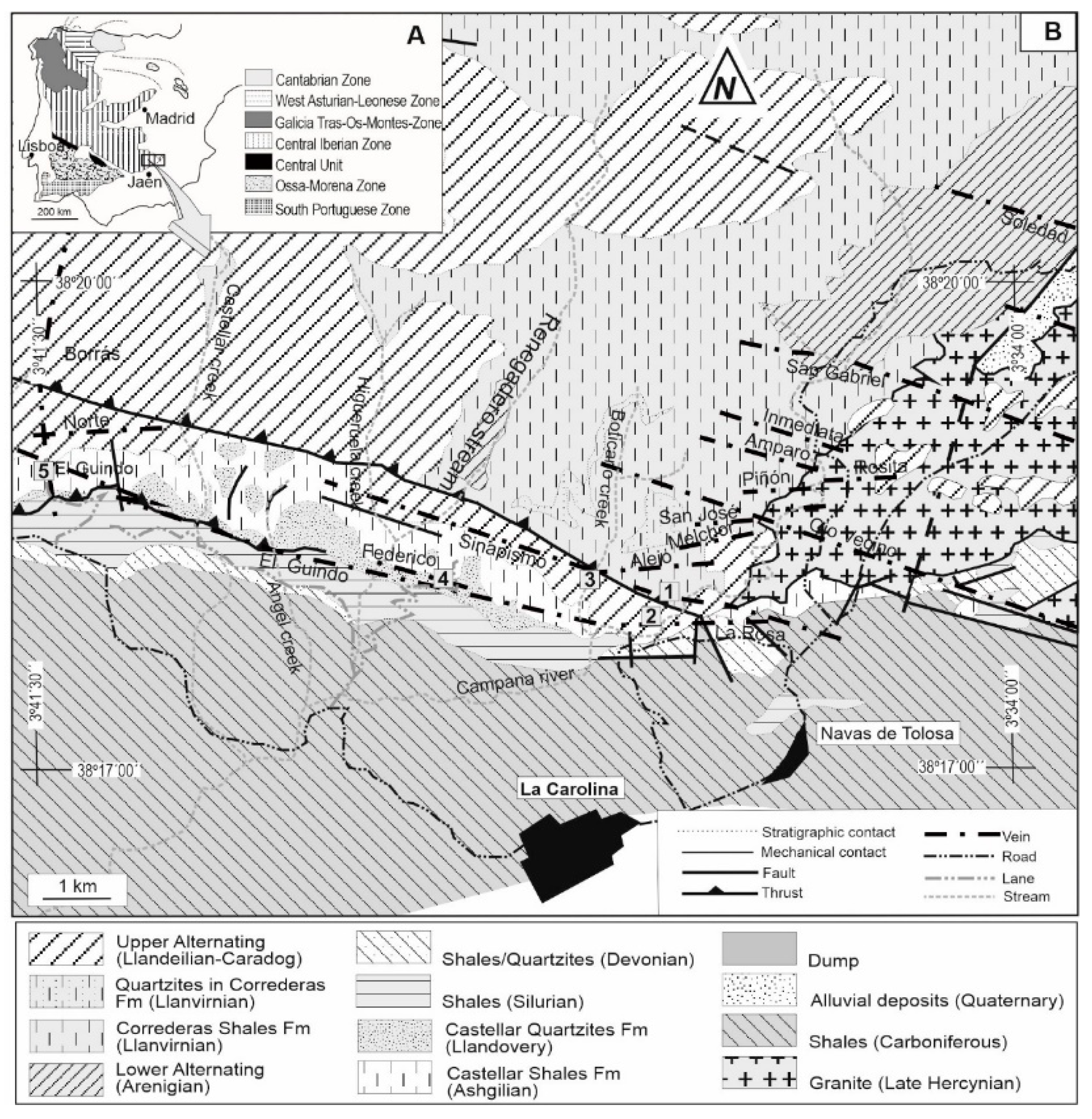
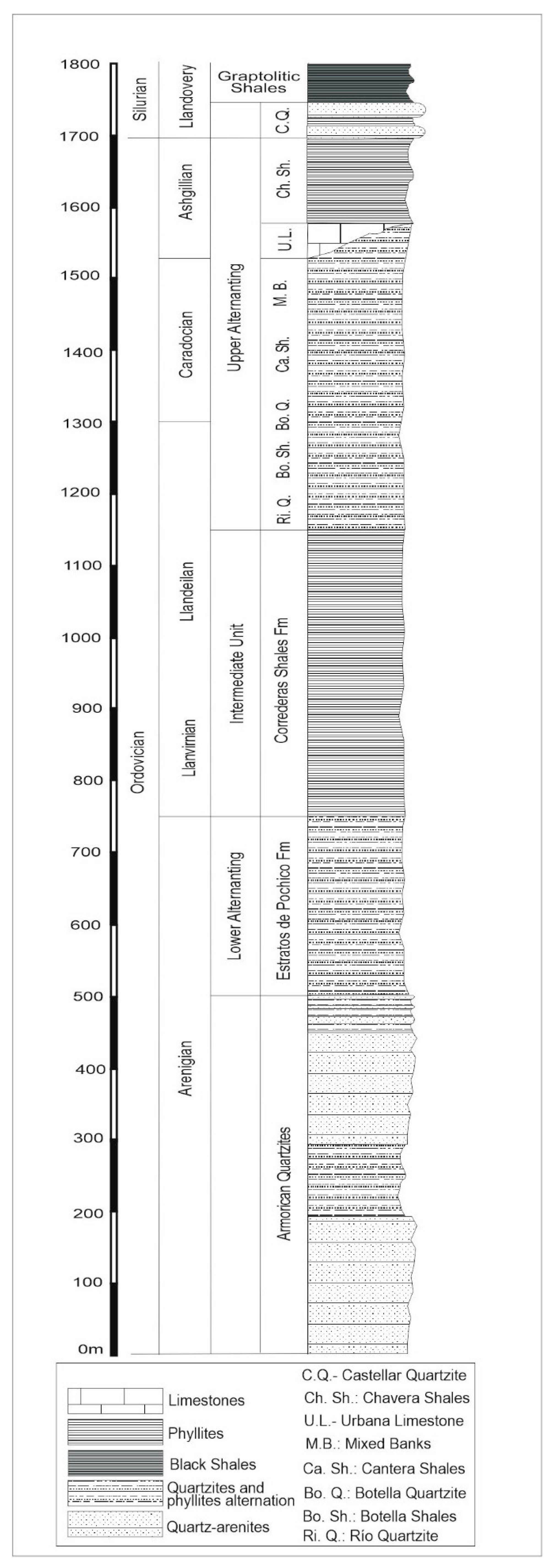
2. Geological Setting

La Carolina mining district is located on the southeastern slope of Sierra Morena, in the southeastern border of the Hesperian massif [24] in the Central Iberian Zone [25] (Figure 1A). From a regional point of view, two large assemblages of materials can be differentiated, namely, an intensely deformed Paleozoic basement containing mineralizations and a subhorizontal sedimentary cover that fossilizes them.
The Paleozoic basement consists of a succession of metasedimentary rocks (mainly phyllites and quartzites) of Ordovician to Carboniferous age and has been studied previously [23,24,25,26,27,28,29,30,31,32] (Figure 1B and Figure 2). A characteristic of this district is the presence of a granitic massif located at the end of the Hercynian orogeny (Castello and Orviz, 1976; Lillo et al., 1998a). The Ordovician series is essentially the host rock of the mineralization, within which a set of units has been defined as a function of the existing quartzite proportion [32], which allows to differentiate, from oldest to youngest, the Armorican Quartzites, the Lower Alternating Fm, the Correderas Shales Fm, the Upper Alternating Fm, and the Castellar Shales Fm (Figure 1B and Figure 2).
The Armorican Quartzites constitute a unit of approximately 450–500 m thick white orthoquartzites, sometimes appearing somewhat pink, with some level of siltstones or mudstones. In these facies, ichnofossils of Skolithos and Cruziana are attributed to the middle of the Arenigian (Tamain, 1972; Ríos, 1977; Lillo et al., 1998b). As can be observed in Figure 2, the presence of an intermediate section of alternations of orthoquartzites and siltstone pelites would allow for the definition of three members [30,32,33].
On the Armorican Quartzites, the “Pochico Strata Fm” appears, with thicknesses of the order of 250 m [30,33]. It is an alternation of quartzites, quartzitic sandstones and more or less sandy pelites. Based on the stratigraphic position and on the ichnofacies present, mostly Cruzian, this lithostratigraphic unit has been attributed to the Arenig [34]. Geological studies of mining companies in the sector have used the term “Lower Alternating” for this unit.
The Correderas Shales Fm, directly on the Armorican Quartzites, range from approximately 400–600 m in thickness. It is a purely slate unit with dark colours. The abundant fauna of trilobites and brachiopods facilitated the dating of the Llanvirnian-Llandeilan [34,35]. The term “Intermediate Unit” has been used in local mining studies to refer to this unit. These lithologies have equivalents for the same age throughout the Central Iberian Zone [23], and they receive different names (Río Shales, Tristani Beds).
The Upper Alternation is deposited on the Correderas Shales Fm. In brief, it is an alternation of pelites and quartzites. It is in this unit that a large portion of the mining of the La Carolina district lies, and it has therefore been studied in great detail. The variable predominance of quartzitic facies allows for the differentiation of different lithostratigraphic units [31,33], namely, Río Quartzite, Botella Shales, Botella Quartzite, Cantera Shales, Mixed Banks, Urbana Limestone (discontinuous) and Chavera Shales (Figure 2). The associations of brachiopods, trilobites or conodonts have allowed for the dating of the Llandeilan, the Caradocian and the Ashgillian [33,34,35,36].
On the Ordovician, there is a unit consisting of large quartzite banks with thicknesses varying between 40 and 70 m, defined as Castellar Quartzite [36]. Equivalent materials have also been described in other sectors of the Central Iberian zone [23], where they received local names in Spanish (Cuarcita de Criadero, Cuarcita de Valdelasmanos). In the upper part of this unit, there is an association of graptolites dating from the Silurian (middle Llandovery). Above this unit appear very dark pelitic facies approximately 100 m thick that were defined as the “Graptolitic Shales” [36]. The association of graptolites indicates an upper Llandovery.

3. The Mining District

The philonian rocks in La Carolina are associated with extensional conditions, and the anomalous geothermal gradient originated at the end of the Hercynian orogeny [26,27]. These mineralizations have a hydrothermal origin, whereby the fluid phase and metals were injected through the fractures and discontinuities of the granitic mass and the Paleozoic host rock [26,27]. These veins mainly consist of galena, sphalerite, chalcopyrite, pyrite, quartz, ankerite and calcite and fit in the Paleozoic basement and in the granitic body [29]. In the northeastern sector of the district, they have a predominant N110E/E-W strike (Figure 1B).
In general, the veins have a high dip and extend longitudinally for several kilometers. The mineralizations within the philonian unit are concentrated in lenticular enriched areas. Lithological control is fundamental in mineralization, as the veins were metallized when they were strengthened in quartzites and rapidly became depleted when reaching phyllites (Figure 3 and Figure 4). Mechanical factors were responsible for this process since competent materials (quartzites, sandstones and granite) allow frank and net fracturing, while incompetent materials (phyllites) react to the stress by deforming; thus, creating open spaces was difficult.

4. Mineral Exploitation and Concentration Systems in the Mining District

The underground mining method used in this mining district was shrinkage stopping, a common system for philonian deposits with subvertical dips embedded in granites or quartzites [17]. This technique consisted of removing the ore by drilling and blasting by ascending horizontal strips from the bottom up. The blown ore was left in the hole to serve as a working platform and as a temporary support for the gables until finally being evacuated when the chamber excavation was complete [37].
From the stripped materials and after a previous separation operation in the mine, grades between 18% and 20% galena were obtained. Subsequently, the mineral concentration was structured in two stages. First, the material was subjected to a gravimetric process from which a first concentrate of galena was obtained along with a high-grade mixed (composed of host rock and ore minerals) and wastes. The mixed and waste samples were then treated in a flotation process. To release the mineral, flotation required grinding so that the diameter of the particles was below 1 mm (approximately 50–70 µm), resulting in a second concentration of galena and tailings in this process.
The waste from the process was pumped and deposited into tailings dams, which required a dike structure to contain the sludge. The dikes were built with materials from the excavation of mine galleries (blocks and gravel) in the form of closed rings for structures on plains or as a containment dam when using a trough (more common in this sector of the mining district). The regrowth of the dike with the flotation wastes was typically upstream and was carried out by pumping or by guttering (gravity). It should be noted that none of these mining dams were waterproofed in the Linares-La Carolina district, with the tailings being deposited directly on the ground, posing a great environmental risk [38,39,40,41]. To obtain an idea of the magnitude of the problem, at least 32 tailings impoundments have been inventoried in the mining district of Linares-La Carolina alone [17].

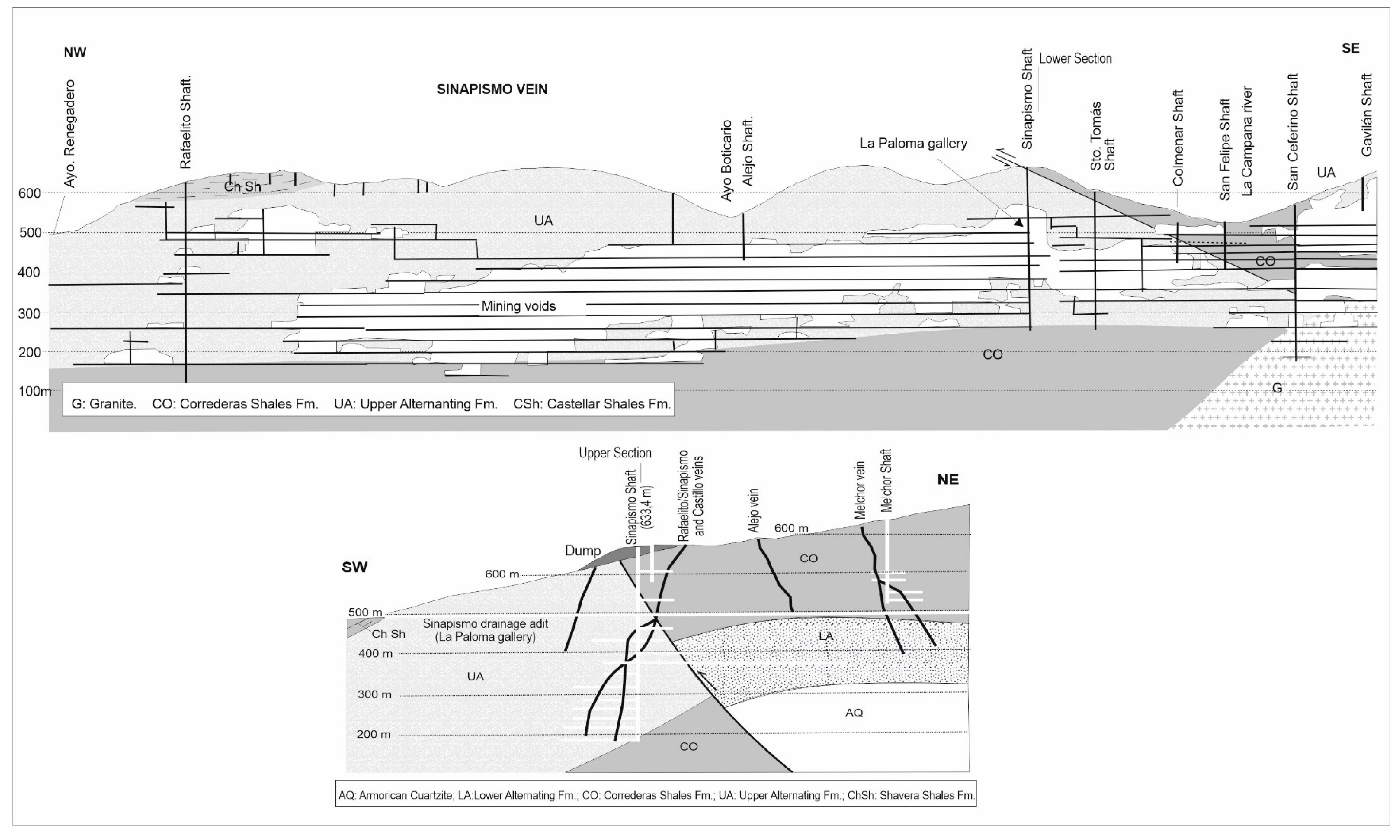
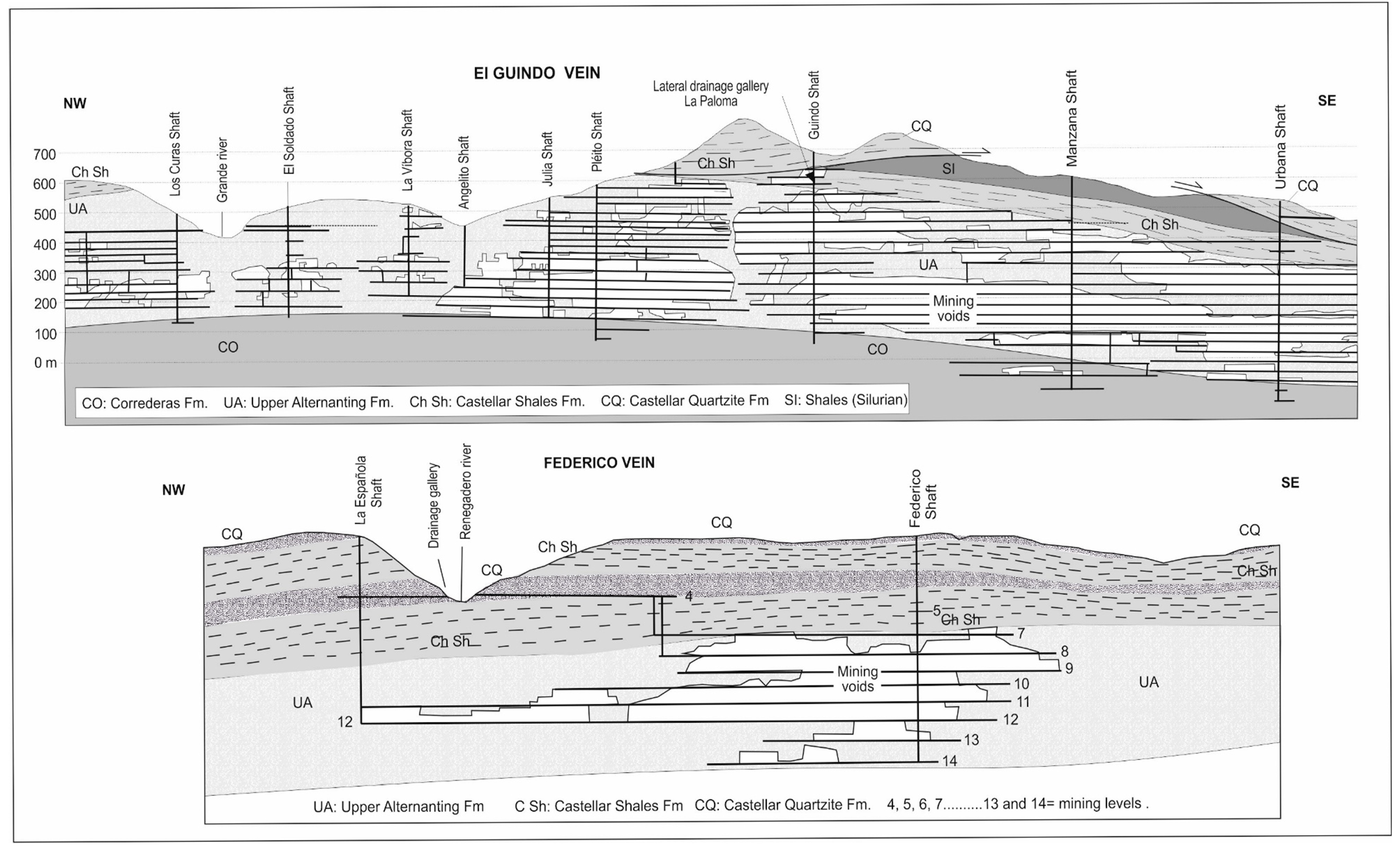
5. The Main Veins of the Northeastern Sector of the Mining District

The eastern sector of the mining district contains three important veins (Figure 1B), i.e., El Sinapismo, Federico and El Guindo; these veins N110E are subvertical and subparallel.
The El Sinapismo vein is one of the most important veins in the Linares-La Carolina mining district. It was mined for more than 6 km and to depths of 550 m. Stratigraphically, it fits into materials of the Upper Alternating and becomes depleted at depths when penetrating the Correderas Shales Fm (Figure 3). It presents notable bifurcations, and towards the east, it has been mined, which is embedded in the granite. As shown in Figure 3, mining works reached levels below 100 m and were flooded up to 470 m [42] (Figure 3).
In the 1960s, a exploration gallery was constructed perpendicular to the El Sinapismo vein (La Paloma gallery), with the idea of locating new mineralizations [21]. It has a length of 1170 m and cuts a series of secondary veins (Fuente vein, Alejo vein, and Melchor vein, Figure 3). This gallery (also known as La Paloma drainage adit) currently has easy access from the vicinity of the Campana River at an elevation of 495.7 m (Figure 1B). From the observations made inside the adit, it was confirmed that the first 480 m contains an alternation of pelites and quartzites of the Upper Alternating (Figure 3) that dips slightly towards the S-SE. These facies were affected by folding with an inverse flank vergent towards the north. From this contact, the gallery runs through pelitic subhorizontal facies attributed to the Correderas Shales Fm or the upper part of the Lower Alternating (Figure 3). Advancing this gallery from this contact made little sense, since the mineralizations were very impoverished in these pelitic facies; instead, a better use may have been to perform mechanical drilling and verify the existence of mineralizations in the Armorican quartzite at depths suitable for mining.
The El Guindo vein is another one of the most important veins in the mining district, with a run of more than 10 km (Figure 1B). The thickness of the vein, sometimes bifurcated, reached two metres, with quartz and galena fillings. It fit into the Upper Alternating, and metallization disappeared towards the roof in the Shavera Shales and towards the wall in the Correderas Shales Fm (Figure 4). It was mined up to 600 m deep. The three most important shafts of the vein were the N1 of El Guindo, the La Manzana and the Urbana. This last mine shaft can still be visited since it can be accessed from the surface through the gallery of level 1 (Figure 4).
The Federico vein is parallel and very close to El Guindo and could be considered a branch of it (Figure 1B). It has been exploited for a total run of approximately 900 m to a depth of 340 m (Figure 4). The two main shafts were Federico and La Española, linked by level 14. However, it is worth noting the existence of a drainage adit in level 4 that discharges its waters to the Renegadero stream (Figure 4). This point was used for the control and chemical characterization of the waters that flood the vein [42].

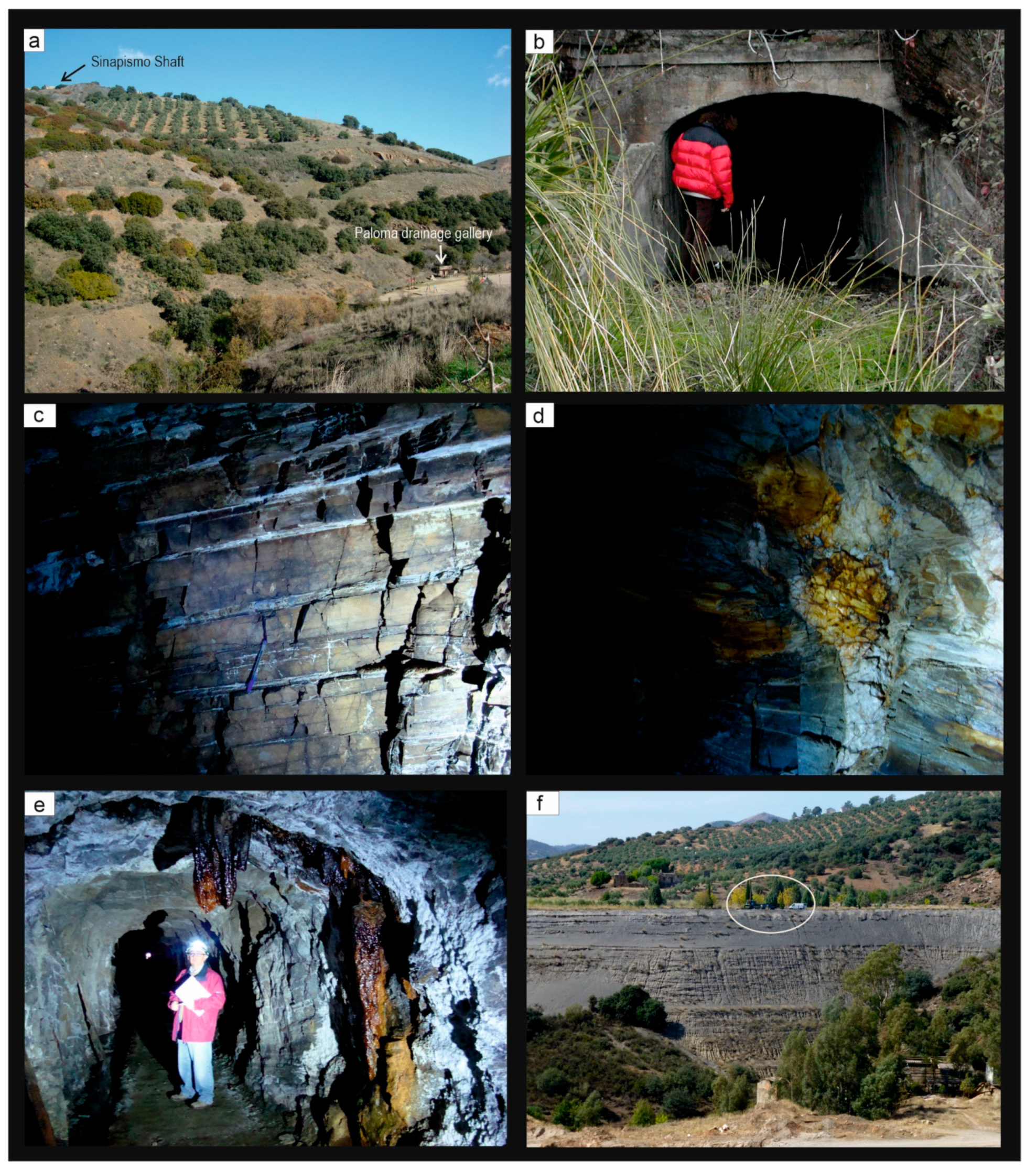
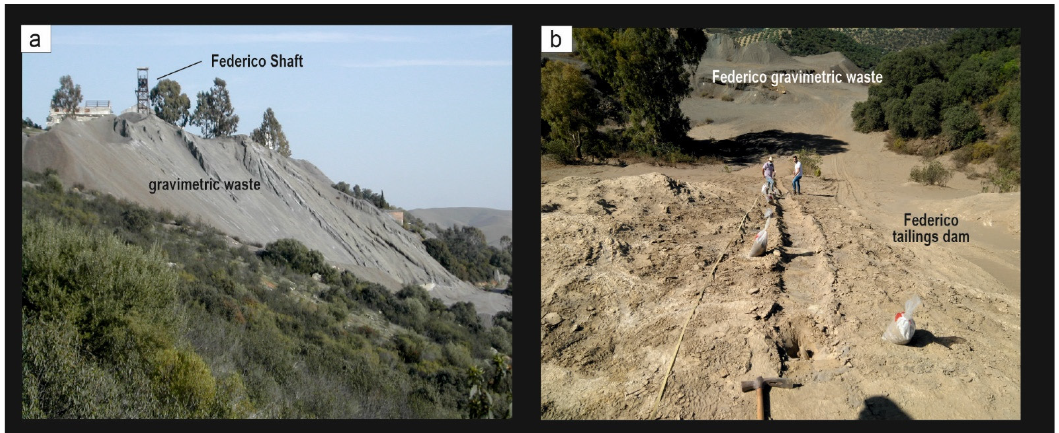
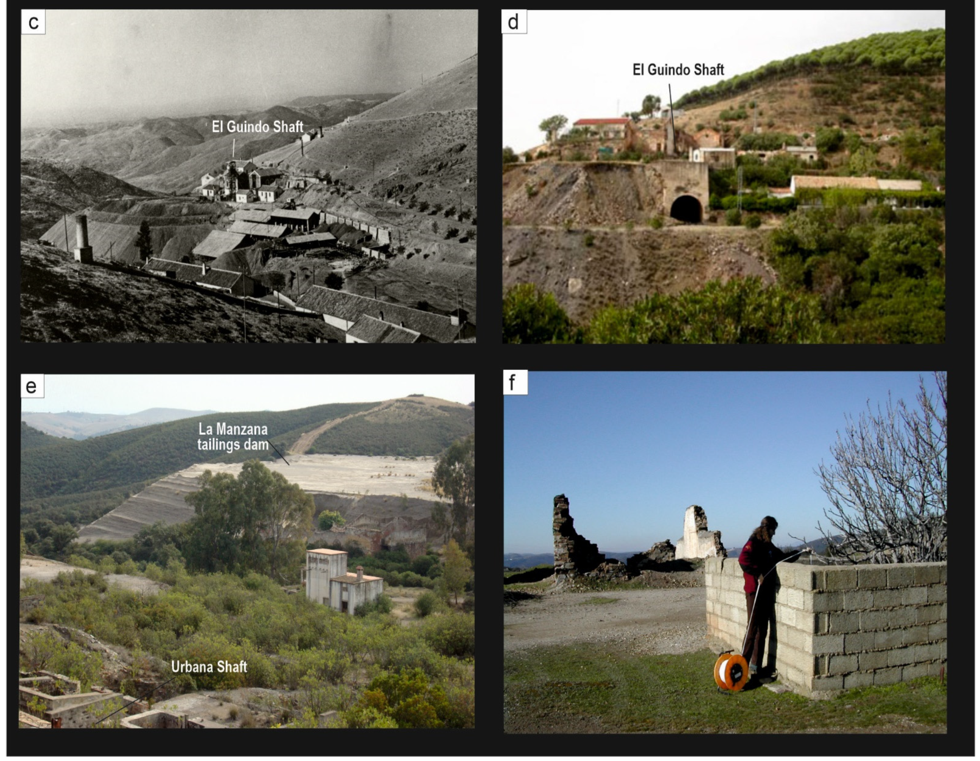
6. The Geo-Mining Itinerary

The first stop of the geological mining itinerary is proposed in El Pozo no. 1 of the El Sinapismo vein (Sinapismo shaft) at an elevation of 633 m (1 in Figure 1B). Its elevated position allows for a panoramic view of the mining district and therefore introduces the visitor to the regional geo-mining context (Figure 5a). Here, the mining pit and the remains of the facilities are still visible, offering an introduction to the exploitation systems. Although the old shaft does not intersect the La Paloma exploration gallery, its route passes very close to the gallery (approximately 10 m), so the connection would be relatively simple and would allow for a combined shaft–gallery visit with two exit routes as a safety measure for future guided tours [20,21].
One of the great tourist attractions of the El Sinapismo vein would be the visit to the La Paloma gallery (2 in Figure 1), the entrance of which offers easy access from the surface (Figure 5b). The alternation of pelites and quartzites of the Upper Alternating are visible in the first 480 m (Figure 5c). Some small veins consisting of galena, sphalerite, quartz, ankerite and calcite are also visible (Figure 5d). In addition, recent precipitates that form the stalactitic structures, which possess great beauty, endow the entire complex with enormous tourism potential (Figure 5e).
Additionally, associated with this vein, a visit to the tailings dam of La Aquisgrana is proposed (3 in Figure 1), whose magnitude would attract the attention of any visitor (Figure 5f). Recently, this dam has been the subject of numerous geophysical prospecting studies intended to characterize its internal structure [40]. In addition, rotary drillings have been conducted to take samples for subsequent geochemical analyses, and sensors have been installed in the tailings impoundment to measure some environmental parameters (oxygen, temperature, humidity, electrical conductivity) at different depths to monitor their evolution over time [42,43]. Therefore, this mining dam may be of special interest to students involved in mining or environmental studies.
In the surroundings of Aquisgrana, there are two other points of interest, namely, the old facilities of the flotation-washing plant (at a somewhat lower level than the tailings dam) and the mining interpretation centre managed by ACMICA (in Spanish).
The facilities of the Federico vein are proposed as the fourth stop in this geo-mining itinerary (4 in Figure 1; Figure 6a). This location offers a panoramic view of the trace of the Federico vein, while the facilities of the Federico mine and the La Española mine can be toured, and the medium-sized wastes of the gravimetric processes can be analyzed (Figure 6a). At the back, at a higher elevation, the tailings dam of the flotation processes is still preserved. Recently, this structure has also been characterized by geophysical techniques [41], and work is currently underway for its geochemical characterization (Figure 6b), which would be of interest for a specialized visitor (Figure 6b).
Finally, for this tour, a visit to the most emblematic facilities of the El Guindo vein is proposed (5 in Figure 1). Although separated by a few hundred metres, it is worth approaching the main shaft (El Guindo, Figure 6c,d) and the Urbana shaft. In the latter, the internal workings can be toured with access from the portal of the first-level gallery. From this point, the tailings impoundment of La Manzana, one of the most important dams of the mining district, can be observed; this mining dam has been characterized both geophysically and geochemically in previous studies [38,39].

7. Development Strategy: Discussion

The Linares-La Carolina mining district comprises 1300 mines, with 65 km of main shafts and 786 km of over-seam galleries, being the largest lead producer in the world from 1875–1920. For this reason, it has an extensive mining, geological and cultural heritage that is considered to have a high impact on tourist, educational and scientific projects. In order to attract these projects, official recognition of its geological interest from a highly prestigious institution, such as UNESCO, has been shown to give rise to geotourism [44].
Official recognition would be the most comprehensive strategy to maintain the geoconservation of these mine sites. However, to reach such a status, the strategy would be to start with this geo-mining itinerary. Although these kinds of revitalization activities required a little economic investment, it should be supported by the local authorities. It has to be noted that currently, tourism development is only carried out by local associations.
Geotourism would be a unique tourist investment in this area, as it offers visitors outdoor activities with a special emphasis on science and education. A recent study reveals that the attractiveness of post-mining areas and the success of tourism development mainly depend on natural landscape, mining heritage sites and architectural features [45]. These mining-related resources are widely available in the study area, and this characteristic is expected to aid in the successful development of geotourism projects. According to previous studies in other former mining districts, mining-related tourist activities are great contributors to the increase in visitors [9,44,45].
On the other hand, it is necessary to disseminate to society the concepts of geoheritage and geotourism, and present the latter as a productive alternative compatible with the local economy. As a current strategy for the enhancement of geological and mining heritage, a combination of GIS and fieldwork evaluation can be used in order to assess and classify the geo-mining sites [46]. This requires the cooperation of the local communities that work in this area with local authorities, tourism companies and the scientific community.
The environmental problems identified in the area would greatly support the involvement of tourism development by the authorities. These anthropogenically influenced landscapes should be managed in parallel with their geoheritage and geotourist values because they are closely linked issues [47,48].

8. Conclusions

Mining-industrial heritage can become a tourist resource capable of acting as a channel for the socioeconomic revitalization of certain territories. This case study aims to enhance the value of the old Linares-La Carolina mining district. For this purpose, an integral use of its geological, mining and metallurgical potential is proposed.
From a geological point of view, there is a thick series of Paleozoic phyllites and quartzites intensely deformed by the Hercynian orogeny and intruded by a granitic batholith. The galena veins are associated with a fracturing phase in the N110E strike. Lithological control was fundamental in the mineralization of these veins since they were metallized when they fitted into quartzites or in the granitic host rock and rapidly depleted when they reached the phyllites. Mechanical factors were responsible for this process since the competent materials (quartzites and granitoids) allow for frank and net fracturing, while the incompetent materials (phyllites) react to stress by deforming, thus hindering the creation of open spaces. All of these factors justify the mining exploitation focusing on materials of the Upper Alternating (predominance of quartzites) and of abandoning the Correderas Shales Fm.
In this study, visits to three of the most important veins have been proposed, namely, El Sinapismo, El Guindo and Federico. The possibility of entering a mining shaft or an exploration gallery is appealing to any visitor. This interest is justified by the number of annual visits to other mining districts already evaluated. In this study, as an added value, it is worth highlighting both the presence of mining and metallurgical facilities and the wastes resultant of all this activity. It is of considerable educational value for disciplines related to mining engineering or the environment.

Author Contributions

Conceptualization and investigation, R.M., J.R., J.M. and M.C.H.; software, J.M. and J.R.; writing and review, R.M., J.R. and M.C.H. All authors have read and agreed to the published version of the manuscript.

Funding

This research was funded by the project FEDER 2020, reference 1380520.

Institutional Review Board Statement

Not applicable.

Informed Consent Statement

Not applicable.

Conflicts of Interest

The authors declare no conflict of interest.

References

  1. Richards, G. (Ed.) Cultural Attracions and European Tourism; CABI Publishing: Wallingford, UK, 2001; 259p. [Google Scholar]
  2. Cueto, G. El Patrimonio Industrial como motor de desarrollo económico. Rev. Patrim. Cult. De España 2010, 3, 159–173. [Google Scholar]
  3. Ahmad, S.; Jones, D. Investigating the Mining Heritage Significance for Kinta District, the Industrial Heritage Legacy of Malaysia. Procedia Soc. Behav. Sci. 2013, 105, 445–457. [Google Scholar] [CrossRef] [Green Version]
  4. Santangelo, N.; Valente, E. Geoheritage and Geotourism Resources. Resources 2020, 9, 80. [Google Scholar] [CrossRef]
  5. Pillet, F. Le Patrimoine Industriel Minier du Bassin de Blanzy, Montceau, Le Creusot (Saône-et-Loire); Éditions du Patrimoine: Dijon, France, 1999; 47p. [Google Scholar]
  6. Pillet, F. Le Patrimoine Industriel Métallurgique Autour du Creusot (Saône-et-Loire); Itinéraires du Patrimoine; Faton: Paris, France, 2001; 64p. [Google Scholar]
  7. Cañizares, M.C. Patrimonio minero y territorio en la Borboña francesa. El “Museo de la Mina” de Blanzy. De Re Met. 2010, 14, 13–22. [Google Scholar]
  8. Gioncada, A.; Pitzalis, E.; Cioni, R.; Fulignati, P.; Lezzerini, M.; Mundula, F.; Funedda, A. The volcanic and mining geoheritage of San Pietro Island (Sulcis, Sardinia, Italy): The potential for geosite valorization. Geoheritage 2019, 11, 1567–1581. [Google Scholar] [CrossRef]
  9. Carrión-Mero, P.; Loor-Oporto, O.; Andrade-Ríos, H.; Herrera-Franco, G.; Morante-Carballo, F.; Jaya-Montalvo, M.; Aguilar-Aguilar, M.; Torres-Peña, K.; Berrezueta, E. Quantitative and qualitative assessment of the “El Sexmo” tourist gold mine (Zaruma, Ecuador) as a geosite and mining site. Resources 2020, 9, 28. [Google Scholar] [CrossRef] [Green Version]
  10. Briševac, Z.; Maričić, A.; Brkić, V. Croatian Geoheritage Sites with the Best-Case Study Analyses Regarding Former Mining and Petroleum Activities. Geoheritage 2021, 13, 95. [Google Scholar] [CrossRef]
  11. Puche Riart, O. Patrimonio minero de España: Aspectos económicos. In Patrimonio Geológico y Minero: Su Caracterización y Puesta en Valor; Rábano, I., Mata, J.M., Eds.; IGME: Madrid, Spain, 2006; pp. 15–24. [Google Scholar]
  12. Cañizares, M.C. Almadén: A excepcional mining heritage. Patrim. L’Industrie/Ind. Patrimony 2008, 20, 39–46. [Google Scholar]
  13. Cañizares, M.C. Patrimonio, parques mineros y turismo en España. Cuad. De Tur. 2011, 27, 133–153. [Google Scholar]
  14. López-García, J.A.; Oyarzun, R.; Sol, A.; Manteca, J.I. Scientific, educational, and environmental considerations regarding mine sites and geoheritage: A perspective from SE Spain. Geoheritage 2011, 3, 267–275. [Google Scholar] [CrossRef] [Green Version]
  15. Kubalíková, L. Mining landforms: An integrated approach for assessing the geotourism and geoeducational potential. Czech J. Tour. 2017, 6, 131–154. [Google Scholar] [CrossRef] [Green Version]
  16. De Tarso Castro, P.; Nascimento, S.T.; de Paula, S.F. Classification of geo-mining heritage based on anthropogenic geomorphology. J. Geol. Surv. Braz. 2021, 4. Available online: https://jgsb.cprm.gov.br/index.php/journal/article/view/127 (accessed on 8 December 2021).
  17. Gutiérrez-Guzmán, F. Minería en Sierra Morena; Ilustre Colegio de Ingenieros Técnicos de Minas de Linares, Granada, Jaén y Málaga: Linares, Spain, 2007; 586p. [Google Scholar]
  18. Dueñas, J.; Hidalgo, M.C.; Rey, J. Itinerario en el Distrito minero La Carolina (Jaén). Colección Temas Geológico-Min. 2000, 31, 457–464. [Google Scholar]
  19. Hidalgo, M.C.; Aguado, R.; López Sánchez-Vizcaíno, V.; Martínez, J.; Rey, J.; de la Torre, M.J. Inventory and valueing of geo-mining heritage in the Linares-La Carolina District (Jaén, Spain). In Geoevents, Geological Heritage, and the Role of the IGCP; Marcos, A.L., Ed.; Elsevier: Caravaca de la Cruz, Spain, 2010; Volume 48, pp. 225–226. [Google Scholar]
  20. Galdón, J.M.; Rey, J.; Martínez, J.; Hidalgo, M.C. Application of geophysical prospecting techniques to evaluate geological-mining heritage: The Sinapismo mine (La Carolina, Southern Spain). Eng. Geol. 2017, 218, 152–161. [Google Scholar] [CrossRef]
  21. Galdón, J.M. Análisis de Viabilidad Técnica para la Puesta en Valor Turístico del Patrimonio Minero-industrial en el Paraje de la Aquisgrana en La Carolina (Jaén). Ph.D. Thesis, University of Jaén, Jaén, Spain, 2018. [Google Scholar]
  22. Diez Balda, M.A.; Vegas, R.; Lodeiro, F. Structure, Autochthonous Sequences, Part IV Central-Iberian Zone. In Pre-Mesozoic Geology of Iberia; Dallmeyer, R.D., Martínez García, E., Eds.; Springer: Berlin, Germany, 1990; pp. 172–188. [Google Scholar]
  23. Ríos, S. Estudio del metalotecto plumbífero del Ordoviense (La Carolina-Santa Elena, Sierra Morena Oriental, Provincia de Jaén). Ph.D. Thesis, University Politécnica, Madrid, Spain, 1977; 271p. [Google Scholar]
  24. Julivert, M.; Fontboté, J.M.; Ribeiro, A.; Conde, L.E. Mapa Tectónico de la Península Ibérica y Baleares y Memoria Explicativa, Escala 1:1,000,000; IGME: Madrid, Spain, 1972; 113p. [Google Scholar]
  25. Gutiérrez-Marco, J.C.; De San José, M.A.; Pieren, A.P. Central-Iberian Zone, Autochthonous Sequences. Post-Cambrian Palaeozoic Stratigraphy. In Pre-Mesozoic Geology of Iberia; Dallmeyer, R.D., Martínez García, E., Eds.; Springer: Berlin, Germany, 1990; pp. 160–171. [Google Scholar]
  26. Butenweg, P. Geologische Untersuchungen im Ostteil der Sierra Morena nordöstlich von La Carolina (Prov. Jaén, Spaien). Münster. Forsch. Geol. Paläont. 1967, 6, 1–126. [Google Scholar]
  27. Azcárate, J.E.; Argüelles, A. Evolución tectónica y estructuras filonianas en el distrito de Linares. In Proceedings of the Congreso Hispano-Luso-Americano de Geología Económica, Madrid, Spain, 19–23 September 1971; Volume 1, pp. 17–32. [Google Scholar]
  28. Castelló, R.; Orviz, F. Mapa y Memoria Explicativa de la Hoja nº 884 (La Carolina) del Mapa Geológico de España, Escala 1:50,000; IGME: Madrid, Spain, 1976. [Google Scholar]
  29. Fontboté, J.M. Mapa Geológico y Memoria explicativa de la Hoja nº 70 (Linares) del Mapa Geológico de España, Escala 1:200,000; IGME: Madrid, Spain, 1982. [Google Scholar]
  30. Lillo, F.J. Geology and Geochemistry of Linares-La Carolina Pb-ore field (Southeastern border of the Hesperian Massif). Ph.D. Thesis, University of Leeds, Leeds, UK, 1992; 377p. [Google Scholar]
  31. Rey, J.; Hidalgo, M.C. Siliciclastic sedimentation and sequence stratigraphic evolution on a storm-dominated shelf: The Lower Ordovician of the Central Iberian Zone (NE Jaén, Spain). Sediment. Geol. 2004, 164, 89–104. [Google Scholar] [CrossRef]
  32. Rey, J.; Hidalgo, M.C.; Martínez-López, J. Upper Ordovician-Lower Silurian Transgressive-Regressive Cycles of the Central Iberian Zone (NE Jaén, Spain). Geol. J. 2005, 40, 477–495. [Google Scholar] [CrossRef]
  33. Tamain, G. Recherches géologiques et minières en Sierra Morena orientale (Espagne). Ph.D. Thesis, University of Paris-Sud, Orsay, France, 1972; 648p. [Google Scholar]
  34. Lillo, F.J.; Pieren, A.; Hernández-Samaniego, A.; Ólive, A.; Carreras, F.; Gutiérrez-Marco, J.C.; Sarmiento, G.N.; Fernández, D.C. Mapa y Memoria Explicativa de la Hoja 862 (Santa Elena) del Mapa Geológico de España, Escala 1:50,000; IGME: Madrid, Spain, 1998. [Google Scholar]
  35. Lillo, F.J.; López-Sopeña, F.; Pieren, A.; Hernández-Samaniego, A.; Salazar, A.; Gutiérrez-Marco, J.C.; Sarmiento, G.N.; Pardo-Alonso, M.V. Mapa y Memoria Explicativa de la Hoja 863 (Aldeaquemada) del Mapa Geológico de España, Escala 1:50,000; ITGE: Madrid, Spain, 1998. [Google Scholar]
  36. Henke, W. Beitrag zur Geologie der Sierra Morena nördlich von La Carolina (Jaén). Abh. Senckenberg. Naturforsch. Ges. 1926, 39, 205–213. [Google Scholar]
  37. Hoek, E.; Kaiser, P.K.; Bawden, W.F. Support of Underground Excavations in Hard Rock; Bolkema Publishers: Rotterdam, The Netherlands, 1995; 225p. [Google Scholar]
  38. Martínez, J.; Rey, J.; Hidalgo, M.C.; Benavente, J. Characterizing abandoned mining dams by geophysical (ERI) and geochemical methods: The Linares-La Carolina District (southern Spain). Water Air Soil Pollut. 2012, 223, 2955–2968. [Google Scholar] [CrossRef]
  39. Martínez, J.; Rey, J.; Hidalgo, M.C.; Garrido, J.; Rojas, D. Influence of measurement conditions on resolution of electrical resistivity imaging: The example of abandoned mining dams in the La Carolina District (Southern Spain). Int. J. Miner. Process. 2014, 133, 67–72. [Google Scholar] [CrossRef]
  40. Martínez, J.; Hidalgo, M.C.; Rey, J.; Garrido, J.; Kohfahld, C.; Benavente, J.; Rojas, D. A multidisciplinary characterization of a tailings pond in the Linares-La Carolina mining district, Spain. J. Geochem. Explor. 2016, 162, 62–71. [Google Scholar] [CrossRef]
  41. Martínez, J.; Mendoza, R.; Rey, J.; Sandoval, S.; Hidalgo, M.C. Characterization of Tailings Dams by Electrical Geophysical Methods (ERT, IP): Federico Mine (La Carolina, Southeastern Spain). Minerals 2021, 11, 145. [Google Scholar] [CrossRef]
  42. Hidalgo, C.; Rey, J.; Benavente, J.; Martínez, J. Hydrogeochemistry of abandoned Pb sulphide mines: The mining district of La Carolina (southern Spain). Environ. Earth Sci. 2010, 61, 37–46. [Google Scholar] [CrossRef]
  43. Rojas, D.; Hidalgo, M.C.; Kohfahl, C.; Rey, J.; Martínez, J. Oxidation dynamics and composition of the flotation plant derived tailing impoundment Aquisgrana (Spain). Water Air Soil Pollut. 2019, 230, 1–16. [Google Scholar] [CrossRef]
  44. García-Sánchez, L.; Canet, C.; Cruz-Pérez, M.Á.; Morelos-Rodríguez, L.; Salgado-Martínez, E.; Corona-Chávez, P. A comparison between local sustainable development strategies based on the geoheritage of two post-mining areas of Central Mexico. Int. J. Geoheritage Parks 9 2021, 9, 391–404. [Google Scholar] [CrossRef]
  45. Armis, R.; Kanegae, H. The attractiveness of a post-mining city as a tourist destination from the perspective of visitors: A study of Sawahlunto old coal mining town in Indonesia. Asia-Pac. J. Reg. Sci. 2020, 4, 443–461. [Google Scholar] [CrossRef]
  46. Szepesi, J.; Ésik, Z.; Soós, I.; Németh, B.; Sütő, L.; Novák, T.J.; Harangi, S.; Lukács, R. Identification of Geoheritage Elements in a Cultural Landscape: A Case Study from Tokaj Mts, Hungary. Geoheritage 2020, 12, 89. [Google Scholar] [CrossRef]
  47. Marescotti, P.; Brancucci, G.; Sasso, G.; Solimano, M.; Marin, V.; Muzio, C.; Salmona, P. Geoheritage values and environmental issues of derelict mines: Examples from the sulfide mines of Gromolo and Petronio valleys (Eastern Liguria, Italy). Minerals 2018, 8, 229. [Google Scholar] [CrossRef] [Green Version]
  48. AlRayyan, K.; Hamarneh, C.; Sukkar, H.; Ghaith, A.; Abu-Jaber, N. From abandoned mines to a labyrinth of knowledge: A conceptual design for a geoheritage park museum in Jordan. Geoheritage 2019, 11, 257–270. [Google Scholar] [CrossRef]
Figure 1. Location map of the Southern Central Iberian Zone [22] (A). Geologic sketch map of the studied region in which the position of the most important veins is indicated [23]. (B) 1, 2, 3, 4, 5: visit areas in the itinerary indicated in the text.
Geosciences 12 00076 g001
Figure 2. Synthetic stratigraphic column for the Ordovician in the studied region.
Geosciences 12 00076 g002
Figure 3. (Top) NW-SE geological section coinciding with the trace of the El Sinapismo vein. The La Paloma exploration gallery is indicated (known as the drainage gallery). (Bottom) A geological section perpendicular to the previous section is represented, passing through the La Paloma gallery. In both cases, the old mining works are depicted.
Geosciences 12 00076 g003
Figure 4. (Top) NW-SE geological section coinciding with the trace of the El Guindo vein. (Bottom) A NW-SE geological section is represented, coinciding with the trace of the Federico vein. In both cases, the old mining works are depicted.
Geosciences 12 00076 g004
Figure 5. El Sinapismo vein (stops 1, 2 and 3 in the itinerary). (a) General photograph in which shaft n° 1 of the El Sinapismo Vein (stop 1) and the La Paloma gallery (stop 2) are positioned. (b) Entrance to the gallery from the surface. (c) Alternation of quartzites and pelites (Upper Alternating Fm) in the interior of the gallery. (d) The gallery cuts small veins filled with quartz, carbonates and some galena. (e) Fracturing associated with water percolation and growth of stalactitic structures inside the gallery. (f) General view of the Aquisgrana tailings dam (stop 3). The presence of the truck is highlighted to illustrate the size of the dam.
Geosciences 12 00076 g005
Figure 6. (a) Federico Mine (stop 4). (b) Sampling for the geochemical characterization of the Federico tailings dam. (c) Photo from the beginning of the last century in the El Guindo vein (stop 5). (d) El Guindo vein today. (e) Old facilities in the El Guindo vein and the Manzana tailings dam. (f) Mine water sampling from an old shaft in the El Guindo vein.
Geosciences 12 00076 g006aGeosciences 12 00076 g006b
Publisher’s Note: MDPI stays neutral with regard to jurisdictional claims in published maps and institutional affiliations.

