1. Introduction
The karstic nature of the Apulia landscape and the history of this part of southern Italy are testified by a lot of sites in which these features meet up. Since the pre-Christian age, numerous caves in the Apulian region were used as places of worship, later becoming churches or small sanctuaries [
1,
2]. In the last decades, the importance of these caves as witnesses of past communities and happenings has greatly increased, since these are sites where the local people recover their own identity. Therefore, the cave churches have been becoming milestones in landscape management, so local authorities aim to preserve them in order to maintain both the local tradition and environment. Moreover, the caves attract tourists and, as a consequence, the fruition of the sites in safety conditions implies a need for caves’ stability assessment [
3,
4,
5]. Furthermore, inside almost all these caves, paintings, engravings and graffiti art from different time periods enrich both the cave walls and niches. Therefore, the archaeometry studies of these artworks can provide precious information for understanding their history and to arrange preservation, as other studies on paintings in different Apulian artistic and archaeological contexts (for example: [
6,
7,
8,
9,
10,
11]) have shown.
Some of these Apulian cave churches are dedicated to Saint Michael Archangel, commonly known as Sant’Angelo, protector of the Lombard stock, imported from the near East and spread through central and southern Italy [
12,
13,
14,
15]. The Sant’Angelo in Criptis cave church (Santeramo in Colle, Bari) is one of these worship places, once full of spiritual life and pilgrim traffic, now abandoned and forgotten.
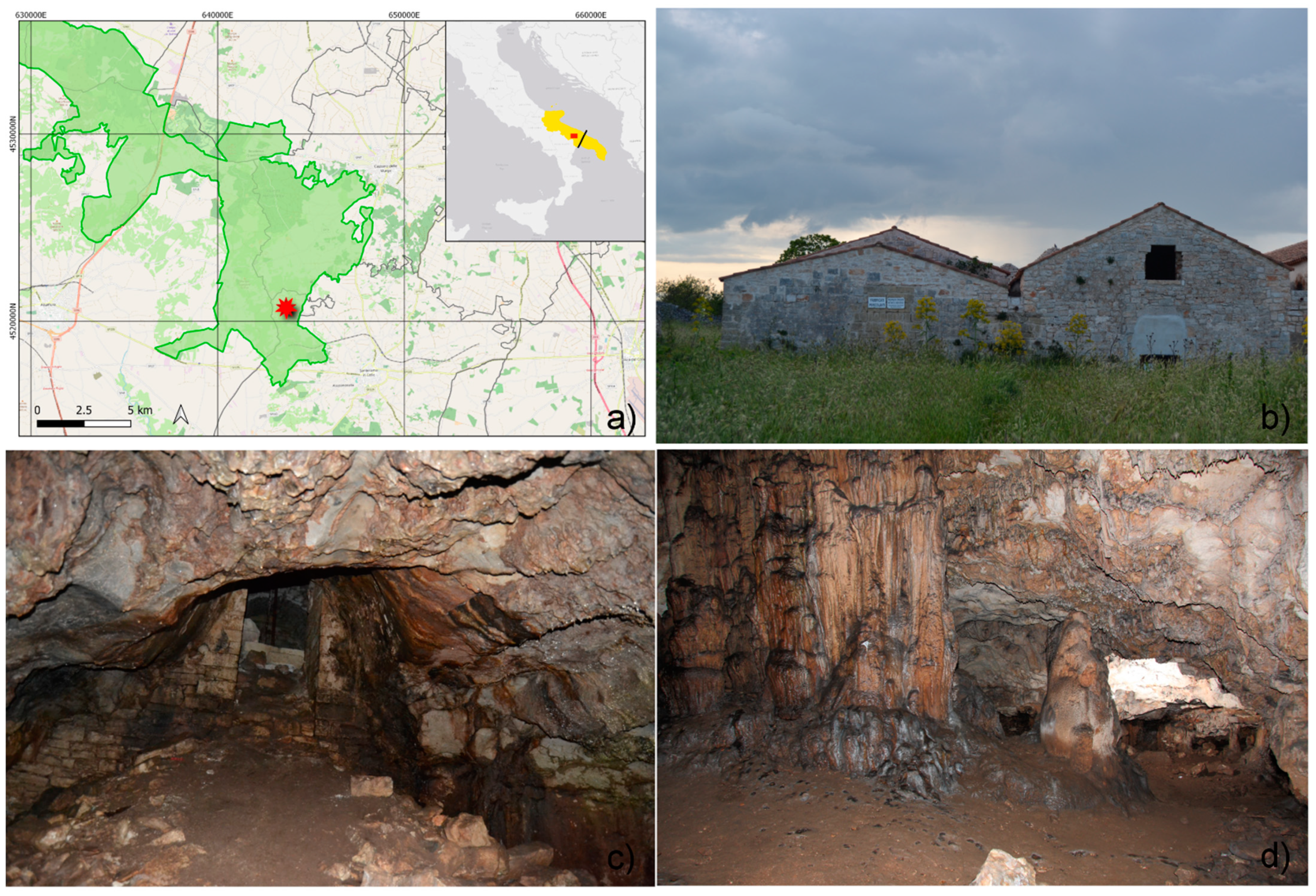
It is a suggestive natural karst cavity, which is part of a wider and more complex structure, locally known as “Iazzo Sant’Angelo” (
Figure 1), consisting of three adjacent buildings (
Figure 1b) that cover the entrance of the cave (
Figure 1c) and overlap the northern end of the cave itself.
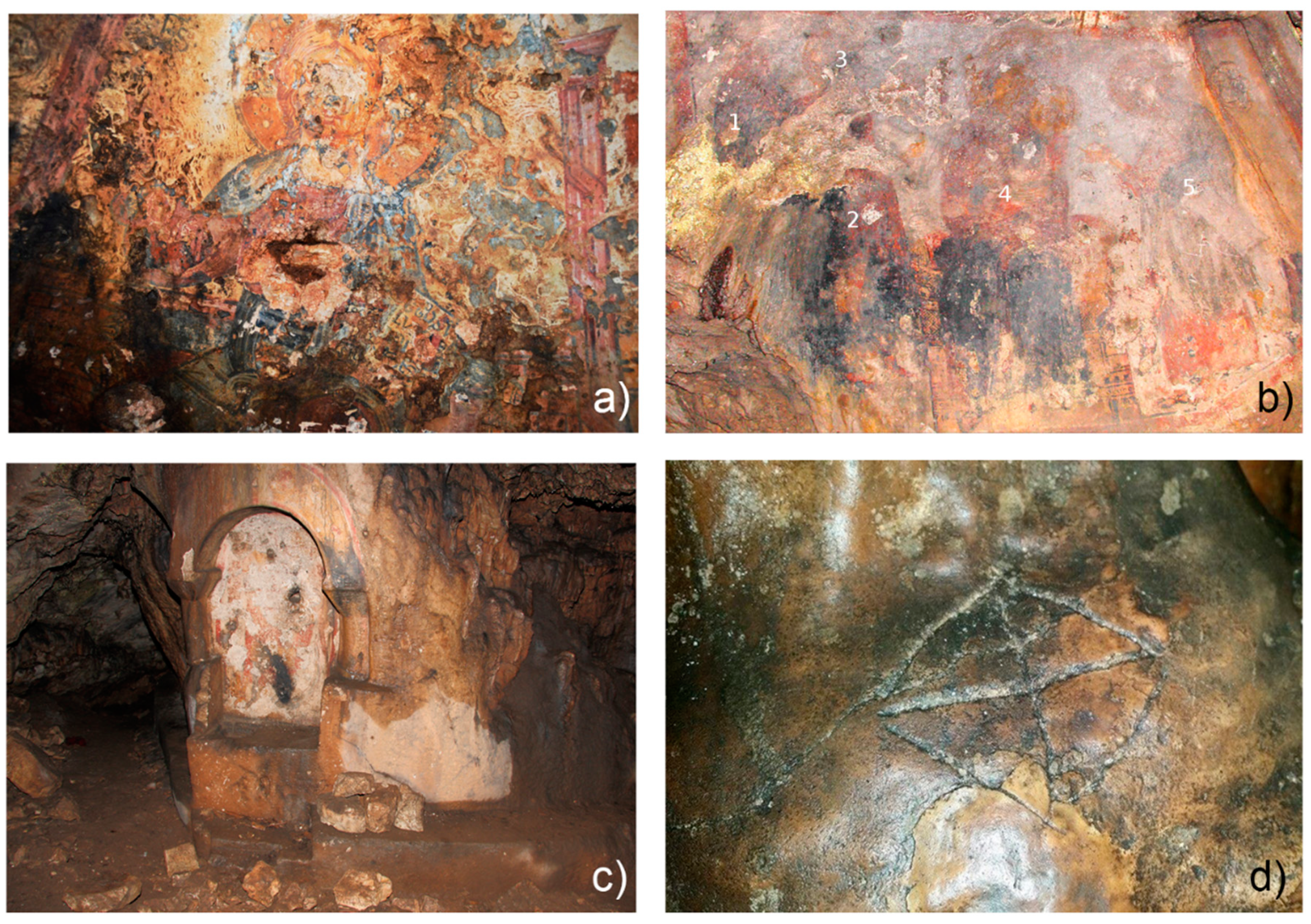
The site was initially used as a church and later as a manor farm. In 1939, Archeological Superintendence for Puglia declared the considerable historical interest of the site and subjected it to protection constraints. The cave represents the core of the historical structure, being characterized by a beautiful underground karst landscape (stalactites, stalagmites, columns delimiting unique niches carved into the rock), in which fine, stratified wall paintings enrich both the cave walls and niches (
Figure 2a–c).
In addition to paintings, cave walls collect engravings and graffiti signs (
Figure 2d) from different time periods, indicating the sacredness of the place, which was an important religious pilgrimage destination since early Christian periods and even before. As a matter of fact, it is likely that the cavity was originally devoted to the pre-classical “cult of water”, and later converted to Christianity and finally entitled, in the early Middle age, to St. Michael the Archangel [
16].
Presently, the paintings, the engravings, the graffiti and the cave are in very precarious conditions as a whole, due to the natural and anthropogenic degradation affecting the cave after its abandonment as worship place (XVI–XVII centuries) [
16].
The inclusion of the Sant’Angelo in Criptis in the Alta Murgia national park (today an aspiring UNESCO geopark in Apulia, Southern Italy,
Figure 1a) permits to consider the site as a typical example of geo-cultural heritage. In this context, the cave church might become a tool for dissemination of the geological knowledge and for the increased awareness about the geological risks linked to human activities and for the landscape protection.
For these reasons, its opening to visits is considered a very desirable opportunitydespite the present conservation condition and the absence of any information regarding the stability of the site does not permit today the public access to the area. To this purpose both the cave and the above church need major restoration and conservation. In this context, the multidisciplinary investigations performed in this work, which is part of a research project financed by the Caripuglia Foundation, aim to renew the interest in this important cultural heritage and focused the attention on the present state of degradation and the stability of the site.
2. The Sant’Angelo in Criptis Cave: State-of-the-Art and Historical Overview
Notwithstanding the beauty of the Sant’Angelo in Criptis site and its past importance as a cultural center, very limited information is available in the literature, both in ancient and in recent sources. Recent literature mainly concerns the description of the cave and its mapping, the paintings and the engravings ([
16,
17,
18,
19,
20,
21,
22] and references therein). All of these reports were mainly devoted to the stylistic and iconographic study of the wall paintings, to the readings of the graffiti and to the reconstruction of the importance of the site as a cultural center, allowing to increase the attention on the complex after a period of total oblivion. This permitted to frame and state the primary role of the Sant’Angelo in Criptis site as a part of the rupestrian culture, highlighting its importance as a place to worship St. Michael during the Longobard period (VII–X century), and even to highlight its importance in the pre-Christian period as a worship place attributable to the pre-classical (or at least very old) “cult of water” [
16].
Before these investigations, very little was known in the literature, and the main difficulty in the reconstruction of the ancient history of the area is the very limited information which can be deducted from the reading of the historical sources, which are limited to the topographic localization of the site in the 1100s, and to some news concerning the collection of taxes from the abbot of Sant’Angelo in Criptis church [
23]. Additional news concern the site dated to the 1700s, when Sant’Angelo was named as a farm ([
23] and references therein). Thus, in the absence of complete literature data, the cave and the housing complex can be considered now as the main sources of information for the reconstruction of Sant’Angelo’s history and of its role in the pilgrimage paths.
All the available literature data regarding the cave describe it as a karst—sanctuary grotto only partially modified by human actions. Through the entrance, connected to the floor of the cavity by means of heaps of debris, which probably substitute a previous wooden stair, the visitors enter in the main part of the cave from which three orthogonally placed tunnels depart. The allocation of paintings on the walls is well-described by Caragnano, 2005 [
24]. The top cave wall at the entrance is marked by the allocation of the “Descent of the Holy Spirit and Christ Pantocrator” painting (
Figure 2a). Immediately on the bottom ofthe debris, there is the handmade niche hosting the painting of “St. Michael Archangel slaying the dragon”, which is actually very difficult to recognize due to the very bad state of preservation (
Figure 2c). On the rock walls at the left of the entrance, there is the painting of “The Virgin and the Child flanked by the St. John and the St. Michael” (
Figure 2b). The iconography of all the paintings makes it possible to date them between the 11th and 14th century [
25]. In addition to the paintings, several ancient graffiti and engravings cover the cave walls (
Figure 2d). Their readings [
21] reveal that the first dedication of the Sanctuary to the Christian cult took place not after the V century; furthermore the presence of early Christian symbology evidenced the deep devotion of the visitors who probably frequented the cave from the beginning of the Christian era, and even before. The impenetrable route carved into the rock and the suffering marks left by pilgrims represent evidence that the cave was the location of a long and difficult path of spiritual purification and pilgrimage. Between the 9th and the 14th centuries, the cave was increasingly popular, so much so that it was probably necessary to dig create new rooms space to accommodate pilgrims; in the 11th and 12th centuries, when the climax of worship occurred, a church was built above and the accessibility to the arduous mystic route in the cave was improved. Wall writings prove that during the next two centuries, the site was still popular, however, its fame decreased until it was gradually abandoned. Starting from the 16th century, the remains of the church were reused as shelter for animals and shepherds [
25]. From the 17th century, the complex of Sant’Angelo was totally forgotten, and its deterioration began [
25]. Up-to-date investigations on the cave and housing complex are totally lacking. Only little information concerning the geology of the area and some preliminary archaeological investigations are available [
23], whereas studies regarding a modern mapping of the cave, its stability assessment and archaeometry investigations of the paintings present therein are totally absent. In this context, the modern multidisciplinary investigations performed in this work aim to fill the lack of information, to implement the knowledge of the area and to act as a base for any future recovery and restoration projects.
3. Geological and Environmental Setting
The cave and the whole housing complex of Sant’Angelo in Criptis (locally also known as Sant’Angelo di Lago Travato) are located in the area known as “Contrada Talpullo-Corte Finocchio”, close to the eastern border of the Alta Murgia National Park, in the countryside north of Santeramo in Colle town. On the geological map of Italy, the site falls in the N. 189 sheet “Altamura” and, in detail, in the Apulian Carbonate Platform. Exactly, it is in the central-western area of the Murge, a karstic plateau whose elevation ranges from 300 to 700 m above sea level.
The geomorphology of the Murge plateau is an effect of a sequence of phases among which karst was fundamental but not always prevailing. The surface drainage, in fact, produced evident landforms that in many places have canceled the karst ones [
26]. They are mainly slightly incised valleys, locally called lame. The drainage evolved both before and after the Plio-Pleistocene transgression [
27]. The carbonate formation involved is the Calcare di Altamura, dated to the Upper Cretaceous [
28], which records the effects of tectonic and morphogenetic events dating from that age.
Furthermore, the typical karst forms, both epigean (doline) and hypogean (caves), are largely modified by not-karst processes, such as coastal abrasion in the transgressive phases, which have created sub-flat surfaces covered by Pleistocene deposits [
29]. On a wider observation scale, the “stepped” structure (
Figure 3) of the carbonate platform in the plateau, as a consequence of the crustal deformation related to the placement of the Apennine chain [
30,
31], is fundamental in the recent (Quaternary) morphogenesis.
Overall, the Murgia relief has a monocline structure, with a SW dip (
Figure 3). A slight bending is believed to be due to an intraplate compressive phase of the Cretaceous period, with axes roughly WNW to ESE [
32].
The exhaustion of the Apennine thrusts is related to more recent distensive tectonics, starting from the lower-middle Pleistocene, and to the general uplift of the foreland margin [
31,
33]. This evolved into a horst-and-graben relief corresponding to the Murge plateau, whose top surface (known as “Murge Alte” or “Alta Murgia”) is bordered by straight scarps. On the other hand, the uplift led to the resumption of erosion in the surface drainage network as much as in the hypogean karst voids, partly pre-existing and obstructed by deposits, which thus are now in a phase of “rejuvenation” of the relief and of speleogenesis [
34], showing recent erosive forms together with relics of ancient fillings, and with new vertical passages.
4. Methodology
The multidisciplinary approach adopted in this work, which includes the geological and geomorphological survey, kinematic cave stability analysis, laser scanner survey, 3D modeling of the site and archaeometry investigations on the paintings therein, represents an integrated investigation methodology applied to the study of cultural heritage aiming at contributing to the protection and promotion of the site as a sustainable tourism resource. The approach used permitted to obtain complementary information, filling the existing gap in the limited literature on the Sant’Angelo in Criptis cave, and provided basic tools for future implementations in different fields, from archaeometry to geology and geoengineering, as well as for historical reconstruction of the site. Ultimately, this study has the aims of scientific documentation collection, dissemination and awareness, which are important parts of fruition and enhancement processes of cultural heritage and tourism.
4.1. Geological and Geomorphological Survey
The site, within its context, has been first considered from a geological perspective. The Alta Murgia has been considered as a geomorphological unit, a horst between a northern scarp about 60 m high near the town of Cassano delle Murge, and the more imposing southern scarp, about 120 m high south of Santeramo in Colle. A search for more caves in the surrounding area has been carried out both in the regional inventory of caves [
1] and among caving clubs. The cave morphology has been considered as a morpho-sequence, including both deposits and morphogenetic processes that shape its voids (erosion, karst corrosion and calcite precipitation, joints and so on), and whose evolution is conditioned by the structural features [
35,
36]. Man-made forms must be considered within such a sequence, since they undergo the same morphogenetic agents in a cave environment.
4.2. Kinematic Analysis of the Cave Stability
In the total absence of similar data, the analysis of the cave’s stability was considered propaedeutic to the other investigations, in order to allow safe access for researchers and instruments into the cave for the complementary studies, but at the same time, fundamental for any future cave fruition. The stability studies were carried out by both in situ and 3D model surveys. To perform a general assessment of the cave’s stability, the above-mentioned field-based geomechanical surveys were conducted by means of both the scanline and the random methods according to ISRM [
37]. It is a near-surface rock mass, in low-stress environments, whose mechanical behavior is significantly affected by discontinuities, and thus it is likely to be highly anisotropic and can be considered as discontinuous. The surveys were integrated with remote sensing techniques by means of a Terrestrial Laser Scanner (TLS) with a high-resolution digital camera, according to the method proposed by Loiotine et al. [
38]. This integrated approach was focused on classifying rock masses according to the GSI and RMR systems [
39,
40] and evaluating their practical modeling for the in situ representation along the roof and sidewalls of the cave.
4.3. The Laser Scanner Survey and the 3D Model Reconstruction
Laser scanner investigations were performed in this study with the aim to create the virtual 3D cave model since visualizing a geological object in 3D greatly improves the inspection capabilities of the scientist [
41]. This methodology is also applied to the cave survey [
4,
42,
43] and to carry out geo-structural analysis of rock mass discontinuities [
44,
45,
46]. In addition, the 3D technology can be easily applied for site and tourism planning and management, marketing [
47], geoheritage-oriented education and research, providing a digital reference and record for future generations [
48]. It allows, in fact, to collect a large amount of exhaustive multidisciplinary information in a unique 3D model and provides data for a lot of applications.
The 3D model of the cave as a point cloud survey derives from high-resolution laser-scanning data: the high density of points allows the feature to be closely fitted, improving the precision of its geometric characteristics [
49]. For this study, a high-speed, high-accuracy Terrestrial Laser Scanner (TLS), Leica HDS 3000, has been used [
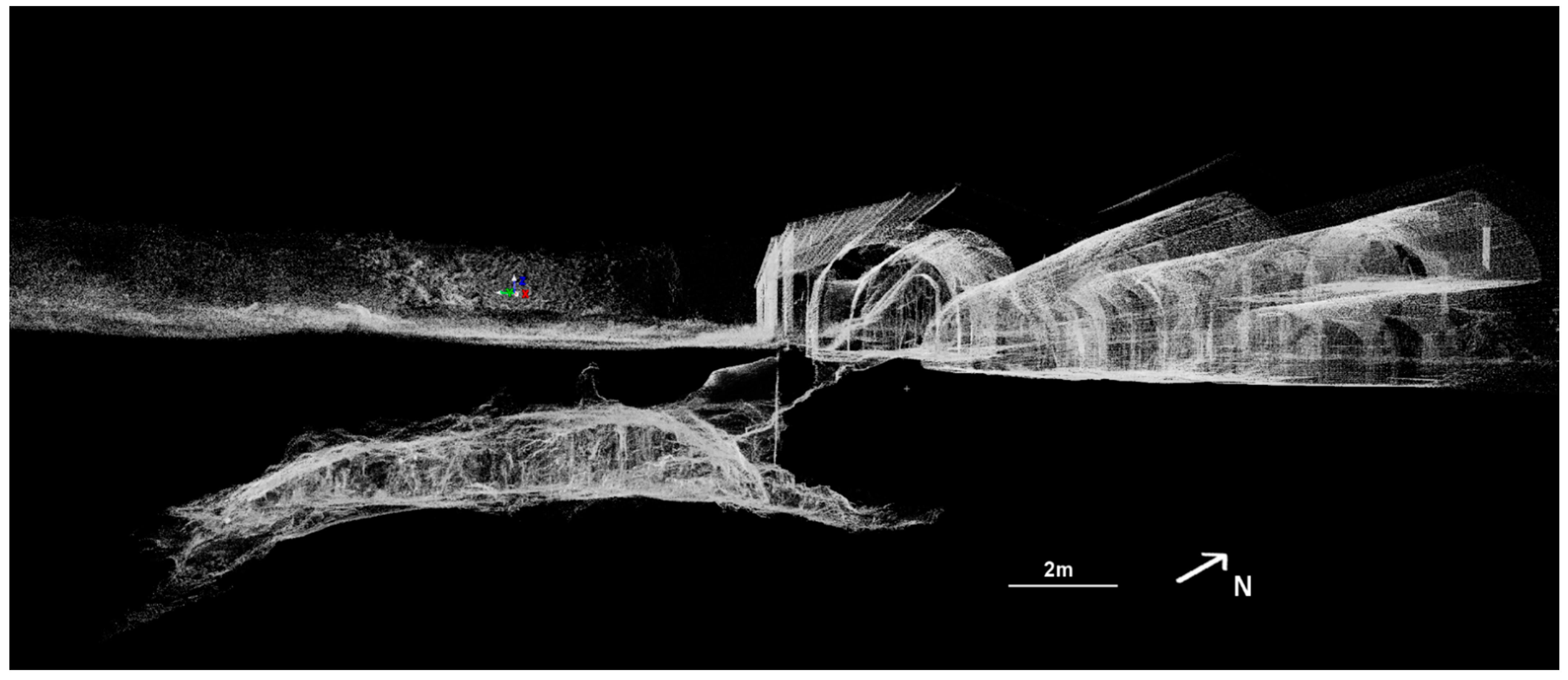
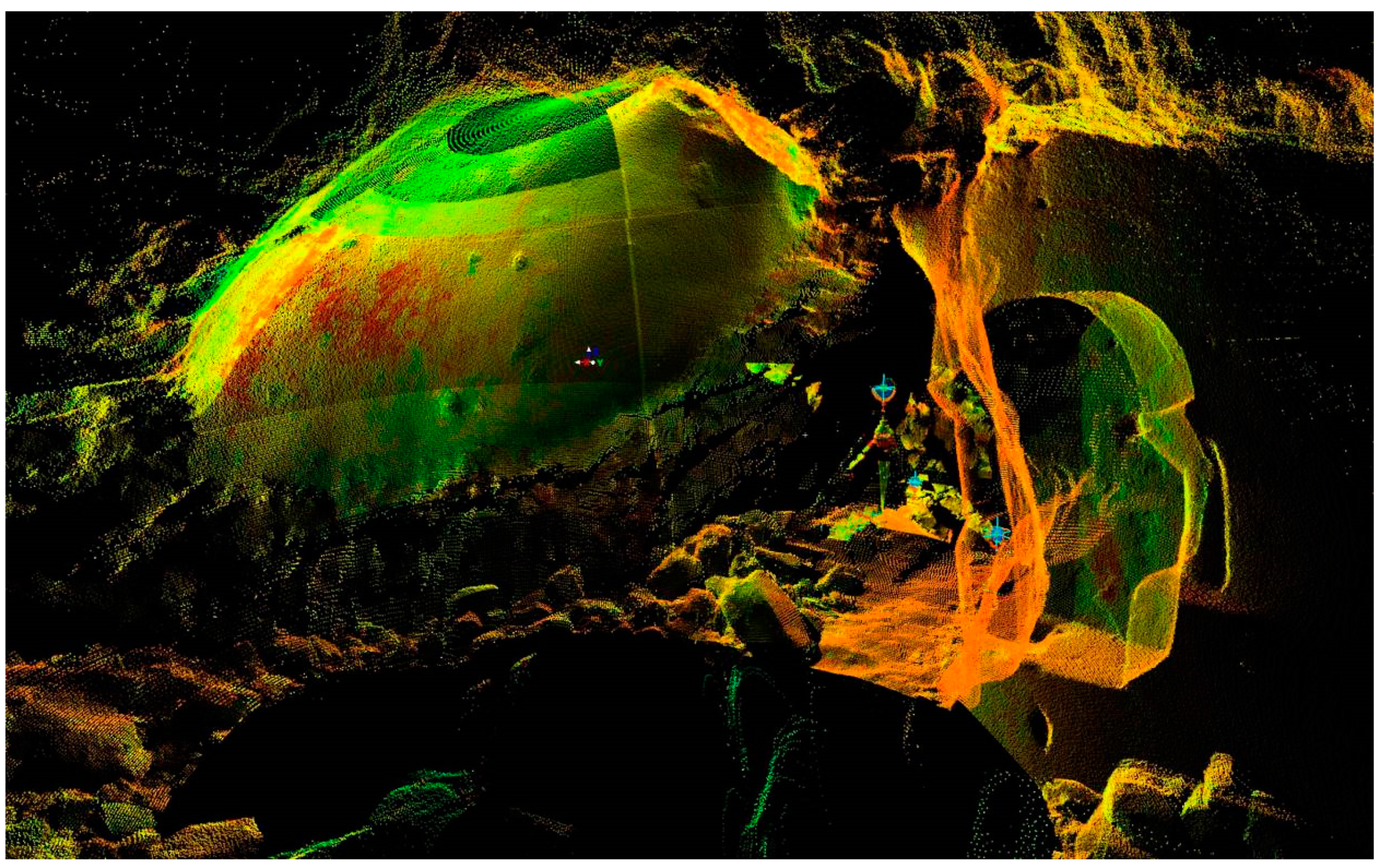
50]. The survey process was developed to gather as much surface as possible. Due to the cave shape and the presence of domes and chimneys on the roof, the scanner was strategically positioned in several locations. In fact, multiple scans at different locations are required to capture the entire survey site, due to the scanner line-of-flight being obscured by structures in one or more of the scan locations. Scan resolutions ranging between 20 and 40 mm both in horizontal and in vertical spacing were used to obtain the raw ground morphology. Each scan contained the highest resolution control points (targets) of the previous scan, thus providing overlaps to join scans into one single point cloud of the whole cave. The survey was carried out starting from the cave entrance, scanning the cave in a clockwise direction, leading back to the starting point, and then carrying on in the building until arriving on the outside, on the countryside plan over the cave (
Figure 4).
The data processing, performed by the Cyclone© software [
50], generates 3D point clouds composed by millions of points according to the spatial resolution previously arranged. Where possible, the scan was cleaned of unwanted objects and then joined together in a unique point cloud. Outside the cave, the position of the overlapping targets was picked up by DGPS in order to georeference the whole point clouds.
4.4. Analysis of Wall Rock Paintings
Archaeometry investigations of wall rock paintings were conducted with the aim to evaluate the state of conservation of the pictorial layers and the preparatory plasters, the presence of degradation products, as well as for the identification of secondary surface deposits. To this aim, a preliminary in situ observation of wall paintings was performed to evaluate, at a macroscopic scale, their general state of conservation, the presence of alteration products and to define the strategy of sampling. Since most of the wall rock paintings in the cave are constituted by the overlapping of pictorial cycles, samples representative of each pictorial layer were taken during the sampling, but in a few cases, painted fragments composed by the complete pictorial stratigraphy were sampled for more detailed stratigraphic investigations. In each case, special attention was paid when selecting samples from already damaged areas in order to preserve the integrity of paintings as much as possible.
A total of 56 stratigraphic samples were collected from the different paintings decorating the wall rock of the Sant’Angelo cave. Specifically, 25 samples were taken from the wall painting which portrays the “Descent of the Holy Spirit and Christ Pantocrator”, 18 samples from the painting showing “The Virgin and Child flanked by St. John the Baptist and the St. Michael the Archangel” and 13 samples from the “St. Michael the Archangel slaying the dragon painting”.
All the sampled fragments were preliminarily investigated under a stereomicroscope and digital images were acquired in order to document their specific features. Thus, cross-sections were obtained for the stratigraphic analysis of the samples finalized to the characterization of pictorial layers and their state of conservation, as well as for the identification of secondary surface deposits.
The analysis of samples’ stratigraphy was performed under reflected-light optical microscopy (RL-OM) and scanning electron microscopy equipped with an X-ray microanalysis EDS system (SEM-EDS). A Nikon Eclipse80i microscope equipped with a digital image acquisition system was used for the RL-OM observations, whereas SEM-EDS analyses were performed using a LEO EVO50XVP electron microscope coupled with a X-max Silicon drift EDS detector (Oxford Instruments, Oxford, UK), equipped with a Super Atmosphere Thin Window. Operating conditions were: 15 kV accelerating potential, 500 pA probe current and 8.5 mm working distance.
The characterization of plasters underlaying pictorial layers was performed on thin sections using a Zeiss Axioskop 40 transmitted-light optical microscope (TL-OM).
5. Results
5.1. The Cave and Its Speleological Context
The search for other caves in the surrounding area produced, as a first result, only 20 records in about 80 square kilometers. The density of caves appears clearly higher along the steeper strips corresponding to the border scarps, straight lines that can be found near the town of Cassano delle Murge (the northern one) and South of Santeramo in Colle (the more imposing southern one). This can be explained not only by the flat topography in the top of the plateau, which certainly limits the intersection of cavities, but also by the actions of human, for the wider use of the land, which often implies the closure of vertical inlets and sinkholes and disposal in cavities of the stones extracted from the crops.
The Sant’Angelo cave is very close to the surface, and its entrance has been modified by man and inserted into the structure of the adjacent building (
Figure 4 and
Figure 5). The entrance leads directly to the main corridor, from which all the others depart. Due to the abundance of both chemical and clastic deposits, the bedrock is hardly visible in the cave (
Figure 1c,d). The speleothems, whose size ranges from recent cannulae to imposing columnar complexes that join the vault and floor as irregular “pillars” (
Figure 1d and
Figure 4), are due to a sequence of deposition events. According to the current model of speleothems’ evolution, the largest complexes originated from stalactite–stalagmite pairs that, thanks to the concurrence of intense water supplies and a sufficiently long time, first joined vertically and finally fused horizontally. The main coarse clastic deposit (boulders) is correlated with the upward migration of the ceiling, in vadose conditions, due to the progressive detachments of slabs, and this sediment is the base of the current walking surface, as well as (apparently) of the largest speleothems. In general, and in particular also in some caves of the Murge, the survey of speleothems and joints allows to identify both the structural factors that in the past have geometrically driven the speleogenesis, and any deformation in progress due to instability or tectonics [
51]. Although the limestone rock mass is rich in joints, in this cave, there is only a limited area (in the NW wall) that shows recent fractures affecting the calcite coating.
It is expected, as it is evident in the topography, that the current morphological evolution of the cavity and its processes are no longer supported by an active hydrogeological basin tributary, nor by water flow through its passages. On the surface, one can find only a limited feeding rock mass, corresponding with the slightly depressed area above the cave, hypothetically a small doline (
Figure 5).
A characteristic feature of the rocky outcrop, both external and internal to the cavity, is the structural one, which is also crucial for the subsequent geomechanical analysis. The presence of some structures (joints) can only be deduced from the alignment of drip points in the vault, materialized by stalactites or cannulae; in those cases, it is possible to infer the direction but not the dip of such joints, unless one can also deduce its path on the wall. For the purpose of a structural and geomechanical investigation, the survey was extended not only to the limited limestone surfaces not coated by speleothems in the cave, but also to small outcrops outside it, where possible, with the limits imposed by the soil cover, such as along the access road and in a small dig in the rock. The data collected indoors and outdoors appear in agreement, with a clear prevalence of the NNW–SSE directions and a dip in the SW sector.
5.2. The 3D Cave Model
The 3D cave model integrates the information that has been obtained by the traditional survey since it allows to identify how the cavity develops: the environment is divided into three main corridors, all easily accessible.
The subdivision is due to massive columnar structures (
Figure 4), formed over a long time, that serve as a support for the vault but also testify to the concentration of dripping percolation along at least three main directions parallel to each other and related to bands of structural weakness. The walkable area of the cave is about 190 m
2, considering the areas high enough to allow human passage and excluding inaccessible areas where stalactites, walls, columns and collapsed material are present. It is also possible to estimate the volume of the void of the cave at about 510 m
3, excluding the concretions and the detrital fan.
The cross-sections along the 3D model provide indications about the vault and the ground level. In fact, they show that the rock thickness (1.5–5 m) is smaller in the area near the entrance and it increases towards the more internal areas according to the conformation of the cave (
Figure 5). However, there are some chimneys that rise up toward the ground level; in particular, one of them in the central corridor rises up to a height of about 1 m on the outside.
5.3. Geomechanical Survey and Cave Stability Assessment
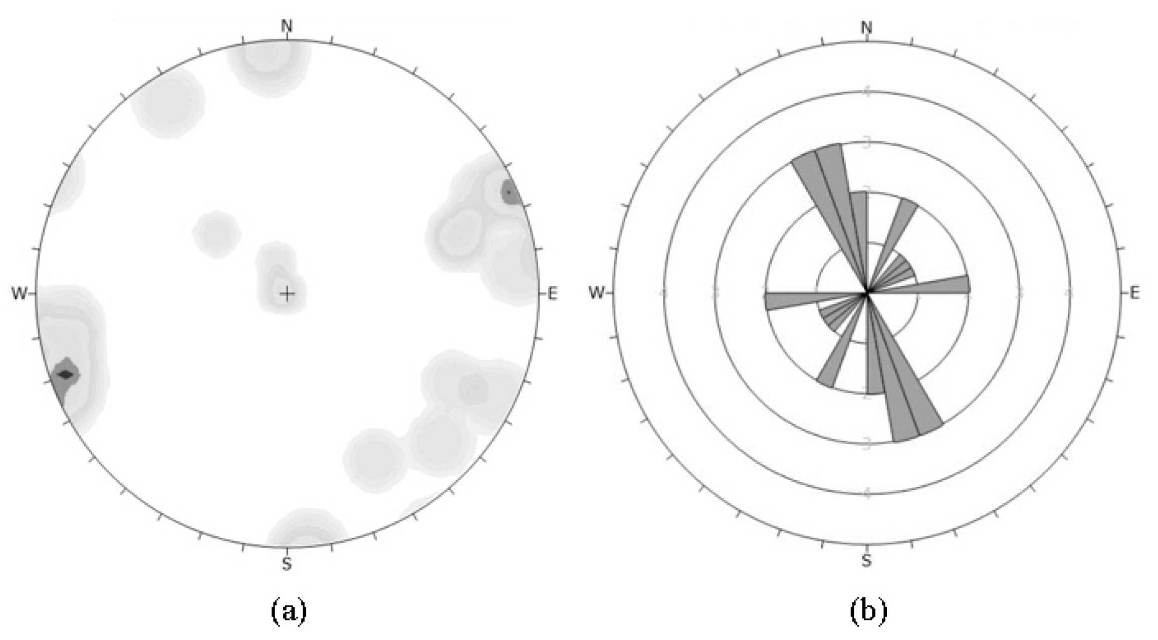
Four main discontinuity sets were identified on the rock mass, generally associated with the tectonic evolution of the study area. Details on the attitudes and relative weights of the sets identified from the integrated approach are summarized in
Figure 6.
In particular, bedding planes show a generalized E–W orientation, ranging from horizontal to 15 degrees SSE-dipping. The main discontinuities exhibit the typical NW–SE and NE–SW orientations, while E–W and N–S orientations are subordinate. Each of them dips more than 60 degrees, except for an extensive closed fracture of 130/40 (dip direction/dip). The rebound hardness index of the rock mass was determined using a spring-driven steel hammer (the Schmidt hammer) for estimating the uniaxial compressive strength (UCS) and the tangential Young’s modulus (Et) of intact rock bridges and discontinuity walls. A standard L-type hammer, with 0.735 Nm impact energy, was used for the in situ measurements [
52]. The UCS and Et values were obtained using the equations proposed by Sachpazis [
53], because they refer to carbonate rock masses such as those found in the study site. For the rock bridges, UCS and Et vary respectively from 61.18 to 104.08 MPa, with mean 74.05 MPa, and from 27.38 to 43.47 GPa, with mean 32.21 GPa. For the discontinuity walls, UCS and Et vary respectively from 18.28 to 61.18, with mean 35.44 MPa, and from 11.29 to 27.38 GPa, with mean 17.72 GPa. According to the GSI classification system, a Geological Strength Index falling in the range 60–70 was assigned to the rock masses cropped out in the study site. With regard to the RMR1989 system, the rating index was 61.
Rock mass conditions and classifications clearly indicated that the rock mass is good and moderately jointed, even though for each joint set, it was impossible to measure the discontinuity persistence, which mainly affects the rock mass strength.
Kinematic analysis was carried out by means of graphical approaches for detecting geometrically possible instability mechanisms [
54,
55,
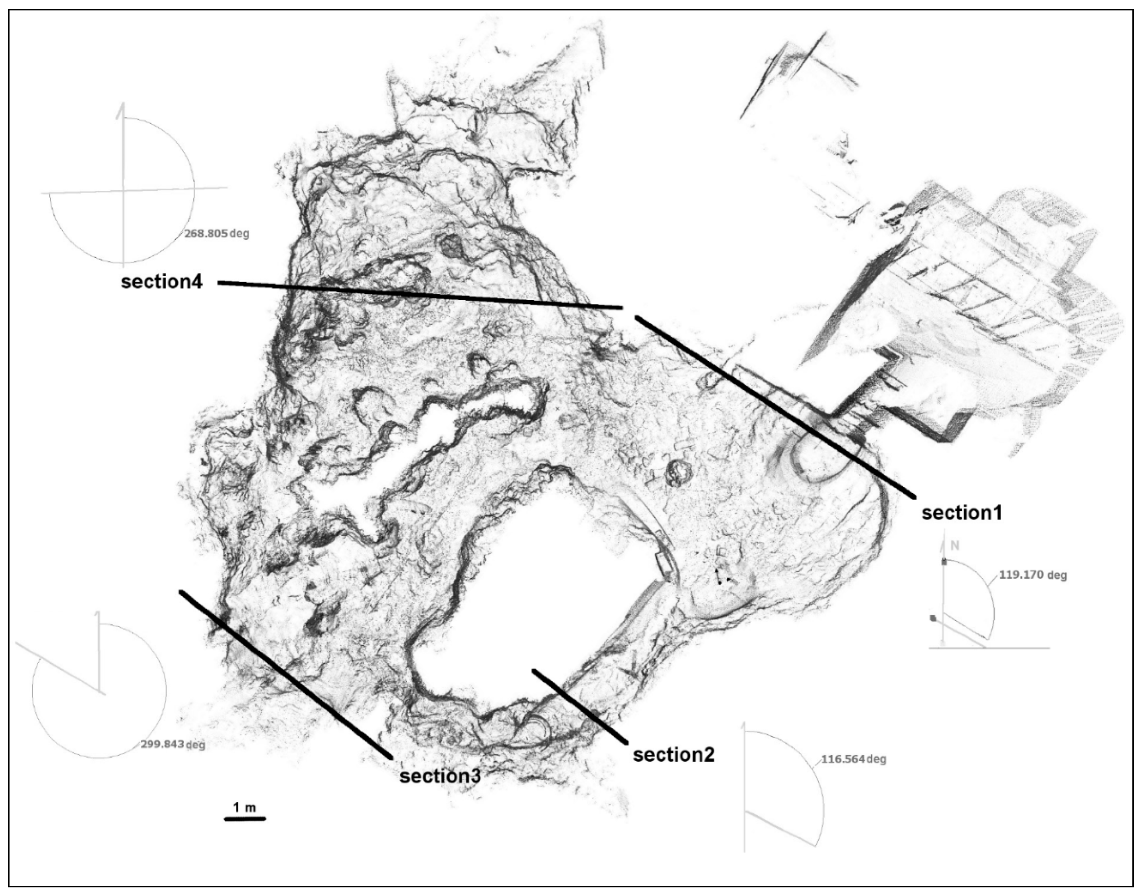
56]. The Rocscience’s Dips 7.0 and Unwedge software were used to perform kinematic analysis of the cave stability for four different sections inside the cave (
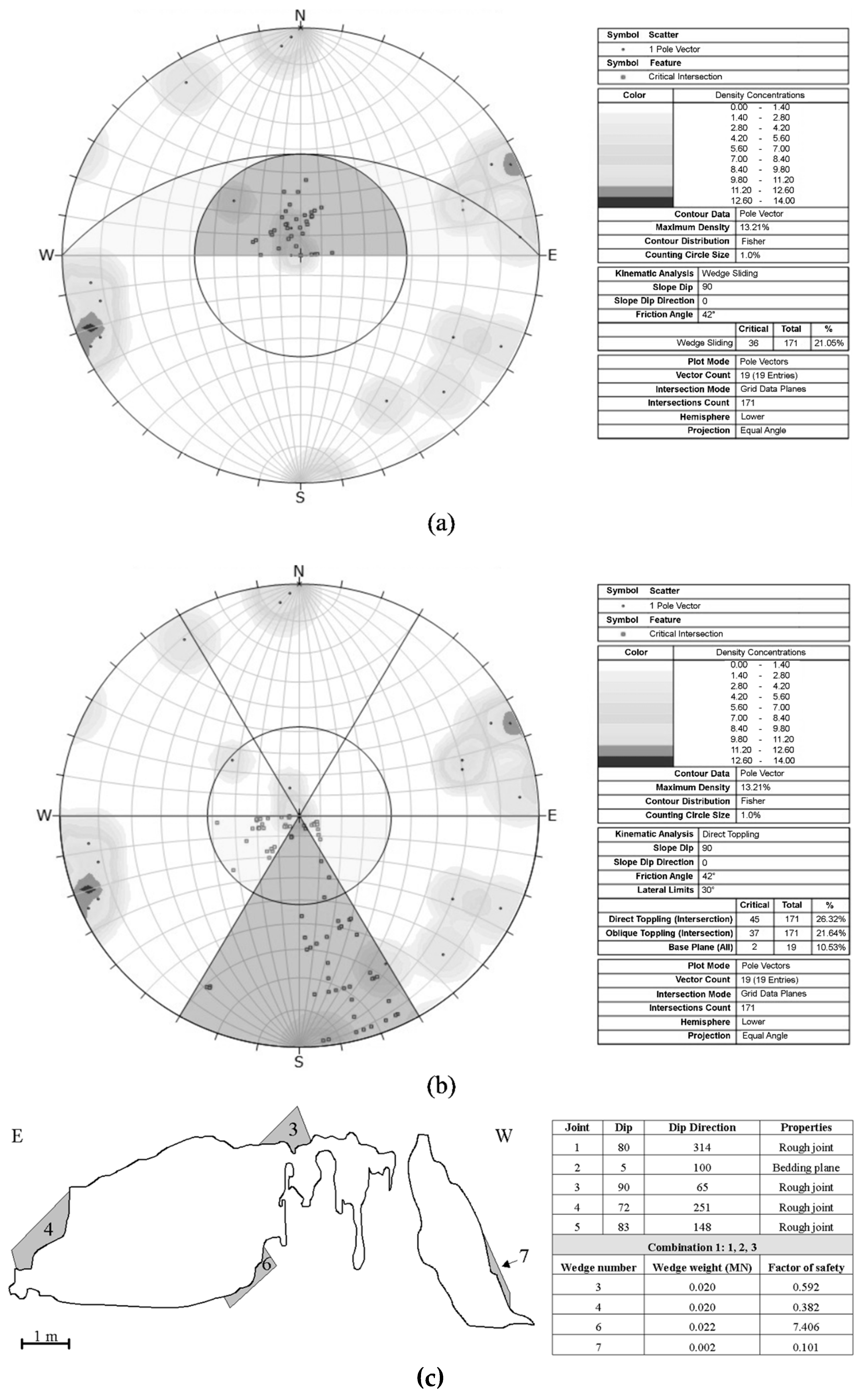
Figure 7). The potential for planar sliding, wedge sliding, flexural toppling and direct toppling failure modes was evaluated assuming full persistence for the discontinuity sets measured.
For each section, deterministic analysis and factor of safety were carried out on about 80 combinations of the 4 joint sets measured. The design seismic coefficient used in the pseudo-static stability analysis was 0.1. Potential failure modes were identified, most of which are attributable to wedge sliding and block toppling from the cave sidewalls and falling from the roof (roof collapse). According to Palmström [
57], the sections considered potential unstable rock blocks exhibit polyhedral shape and volumes generally less than 1 m
3 and only occasionally between 2 and 4 m
3.
Figure 8 shows, by way of example, some results obtained for section 4.
5.4. Wall Rock Paintings: Materials and State of Conservation
After the in situ observation, all the paintings (
Figure 2) in the Sant’Angelo crypt appeared seriously damaged due to both environmental and anthropic causes. Some scenes were fragmentary, lacking cohesion or detached, owing to clear problems of dampness, but in some cases, i.e., in the case of the “St. Michael the Archangel slaying the dragon” painting, the main scenes were lacking due to the removal of the pictorial film for vandalism, so only the preparatory mortar layer and the frame of the original painting is preserved (
Figure 2c). The “Descent of the Holy Spirit and Christ Pantocrator” painting appeared affected by large and numerous losses, mainly in correspondence to the most recent pictorial layer (
Figure 2a), highlighting the older underlying pictorial layer. Instead, the painting “The Virgin and the Child flanked by the St. John and the St. Michael” showed an almost complete superficial pictorial layer, but it appeared covered by a dark deposit, making difficult the reading of the depicted subject (
Figure 2b). There was also a clear presence of plants, fungi and molds, and the decorations were affected by craquelure, losses of the paint layers and deposition of secondary surface deposits, which influenced the rendering of chromatic features and the depicted scene (
Figure 9).
The laboratory investigation of painted fragments showed the occurrence of one single, variable thick, preparatory plaster layer beneath each pictorial cycle. The analysis by TL-OM highlighted a plaster composed by cryptocrystalline calcite binder and an aggregate mainly composed by carbonate rock fragments and minor quartz and feldspars (
Figure 10a). Lime lumps (non-hydrated CaO) are also present in addition to cocciopesto fragments which testify to the hydraulic character of the plasters (
Figure 10b).
The analysis of pictorial layers from all the paintings showed, as expected, the use of common mineral pigments such as red and yellow ochre, carbon black and calcium white, often admixed with each other to produce the desired hue (
Figure 11b). Only one sample showed the presence of cinnabar in addition to the iron pigment of the red layer. A comprehensive characterization of mortars and pigments of painted fragments from the wall paintings in Sant’Angelo crypt is the topic of a separate paper [
7].
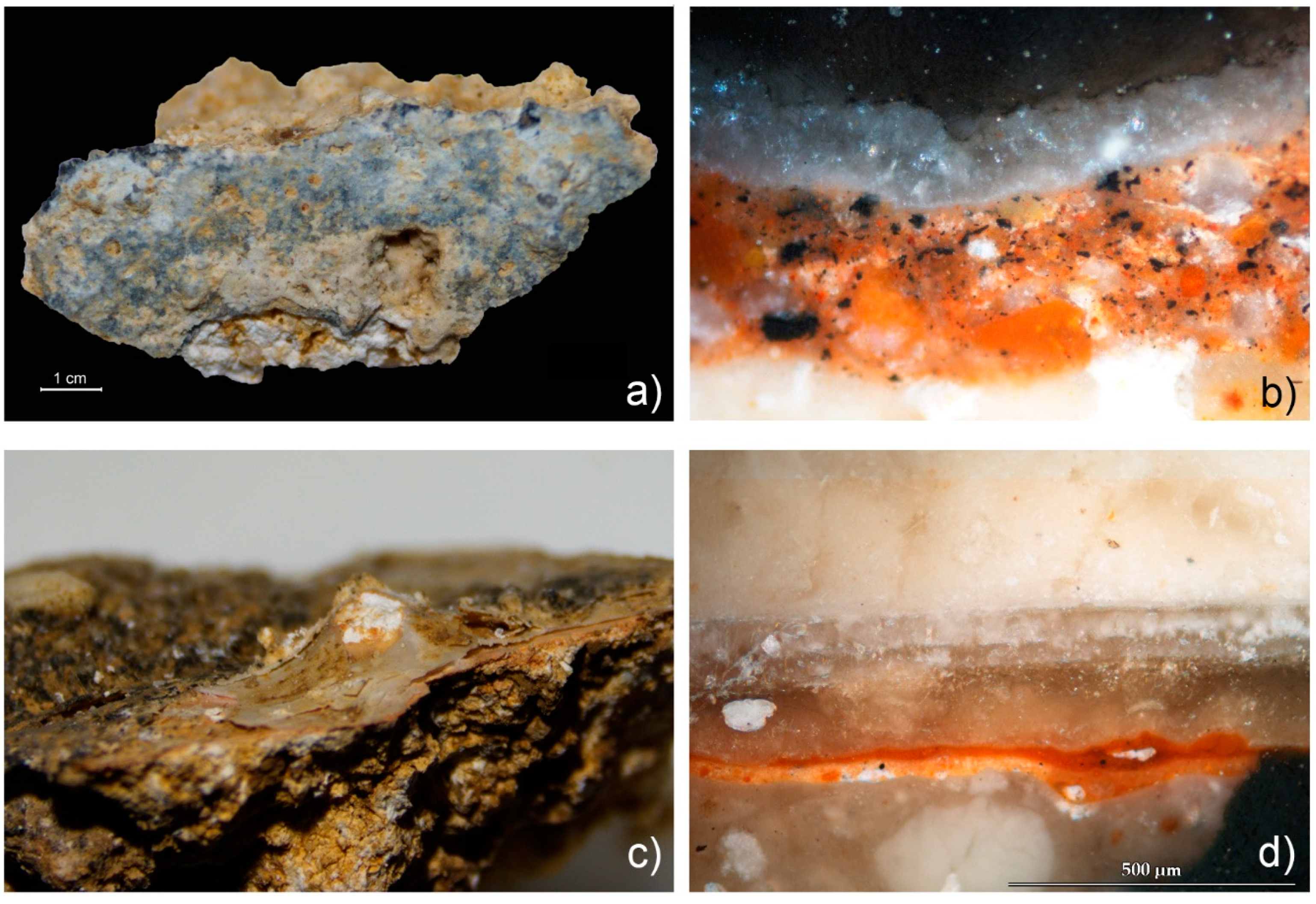
On the surface of the latest pictorial layer, all the samples showed one or more differently thick incrustation coats composed of secondary products related to the physical decay and chemical alteration phenomena linked to the karst activities inside the cave and to the effects of typical environmental degradation (
Figure 11). With the naked eye and under a stereomicroscope, these surface deposits generally appeared as compact brown to yellowish crusts, covering the pictorial layers without producing any chemical alteration and physical disaggregation on their constituting materials (
Figure 11a).
In some cases, encrustation layers were observed on the surface of each pictorial cycle, while in other cases, only a single surface layer of encrustation was observed. The crusts appeared white, opaque and extremely compact under RL-OM (
Figure 11b). Sometimes, however, a less compact surface crust layer showing lamellar morphology was detected (
Figure 11c). In detail, sample CR11 from the wall painting of “Descent of the Holy Spirit and Christ Pantocrator” showed a secondary crust formed by the overlapping of three layers very similar to each other in terms of color, transparency and hardness, and showing vertical and beige–yellowish fractures (
Figure 11d).
The chemical analyses performed by SEM-EDS revealed, in all the investigated samples, the presence of a surface encrustation composed almost exclusively by calcium and oxygen, attributable to calcite (
Figure 12a), in addition to minor chlorine, potassium, sodium, phosphorus and sulfur, which can be related to common soluble salts, namely sulphates, phosphates and chlorides.
Contrary to the pictorial layers, the preparatory plasters underlying the paintings showed more significant chemical and physical degradation effects. They generally appeared powdery and incoherent under OM, whereas SEM-EDS chemical analyses disclosed the presence of relatively high quantities of chlorine, sulfur, phosphate, sodium and potassium, suggesting a more significant formation (if compared to the pictorial layers and encrustations) of common soluble salts, mainly composed by potassium chloride (
Figure 12b).
6. Discussion and Conclusions
The detailed geomorphological study performed herein pointed out the morphological setting and processes that involve the cave and provided significant updates for the fruition and for the conservation of the cultural heritage site. The field surveys and the cave forms show their correspondence with the polycyclic model of the Apulian karst. Processes typical of the vadose zone are evident and predominant here, whereas no form has been recognized that would suggest a phreatic phase in the past. Nowadays, the evolution of the “cave plus surface” system has undergone two simultaneous processes, not necessarily having the same intensity or continuity. First, the degradation of the surface, that proceeds with its lowering, which would lead it towards the cave. Second, the vault of the cave has evidently undergone a “migration” upwards, due to progressive roof failures that contributed to the cave filling, together with the calcite precipitation, leading over time to a reduction in the volume of the original voids together with their displacement towards the overlying surface. On the other hand, despite the advanced degree of evolution of its speleogenesis, and despite the reduced thickness of the rock of its vault, only a limited area of the western side shows fractures that can suggest instability of the rock mass. Some boulders made of speleothems fragments have no clear origin, due to the long history of human actions in the cave, and it is more possible that they were moved by man rather than by previous tectonic or seismic events.
The 3D cave model, derived from TLS, greatly improved the old cave plan with more accurate measurements of the length of the walkways, of the heights of the vaults, of the surfaces and of the relation with the ground level. The cave is not very deep and has close relations with the countryside above, as evidenced by the intense dripping and the presence of many roots, especially near the entrance. The rooms closest to the entrance are those richest in cultural evidence due to the presence of paintings, of the altar and of a lot of graffiti, and this is the area where the visitors stay longer to admire the heritage contained in the cave (
Figure 13).
The 3D cave model allowed to reconstruct the relationship between the ground and the underground levels. The cross-sections highlight that the cave vault, although very regular, somewhere presents chimneys that develop upwards. These features, a few tens of centimeters wide, correspond to areas where the vault rock thickness is very small. This can define areas on the ground forbidden to people in order to avoid damage and stress on the cave vault. Moreover, the stability analysis showed that block failures are structurally controlled and kinematically permissible with wedge sliding, toppling and roof collapse, where in the case of loading, the direction of movement is vertically downwards, but at the moment, there is no evidence of fully persistent discontinuities. We have to also consider that the rock mass is good and not disturbed in an environment with a low in situ stress state. Small signs of spalling mechanisms from the roof are restricted to the sector in which the cave vault is higher (
Figure 5), but shear failures were not recorded.
Furthermore, types and patterns of discontinuities found in the cave are similar to those measured previously in the surrounding area, thus new joints due to changes of stresses or high-stress concentrations in the rock mass were not detected, even though the roof and sidewalls of the cave are covered by calcite concretions which may hide traces of discontinuities.
The archaeometry investigation of the paintings allowed the characterization of raw materials used for paintings and preparatory layers, as well as degradation products, essential information for any kind of intervention aiming at the conservation and the restoration of these artworks.
The investigation of pictorial layers indicated the use of very ordinary pigments: red and yellow ochres, carbon black and calcium white, often admixed with each other to produce a desired hue. The use of these mineral pigments is very common in rupestrian paintings and their finding is not a surprise. On the contrary, the presence of cinnabar, in association to red ochre in some red pigment samples, indicates the particular richness of the site at the time of the paintings’ execution, and confirms the necessity of their preservation through a conservation management strategy for the full fruition of the cave in the future. Unfortunately, at the moment, the rock wall paintings in the Sant’Angelo cave show a generally poor conservation state due to detachments, deposition of secondary phases on the surface of paintings, i.e., calcite crusts, which modify the chromatism of the scenes, or soluble salts such us chlorides, sulfates and phosphates inside the painting layers. These are mainly due to the presence of water on the cave walls, a phenomenon which is particularly critical during the winter. Thus, the significant dampness is the primary source of decay in the crypt, by providing an ideal setting for the migration of salts from the floor and from outside the walls and causing decay effects such as detachments and deposition of secondary phases. However, problems also arise due to the presence of microflora, fungi and molds.
Overall, degradation of paintings in the Sant’Angelo crypt thus originates from physical (mainly due to dampness and capillary rise of water), biological (due to the different micro- and macro-flora that are always active) and chemical (reaction of painting materials with chemical and biological environment) causes, so specific actions are necessary to preserve the memory of this important site for the next generations.
In conclusion, the results obtained in the present study allowed:
To obtain a deeper understanding of the geological and speleological environment and active processes in which the Sant’Angelo in Criptis cave church is located.
To obtain a 3D model of the cave which greatly improves the old cave plan and provides accurate measurements of the length of the walkways, of the heights of the vaults, of the surfaces and of the relation with the ground level.
To evaluate the stability of the cave and its structural assessment.
To characterize materials used for wall paintings present in the cave, degradation forms and to identify the related processes of degradation acting in the cave.
All these goals underline the importance of modern multidisciplinary approaches in the study geo-cultural heritage sites, such as Sant’Angelo in Criptis is. This is due to the complexity and variety of the scientific issues involved, which require joint and complementary competences and analytical methodologies. The results obtained here will contribute to the elaboration of the best methods for the long-lasting preservation, restoration and fruition of geo-cultural heritage sites. Lastly, the spread of the scientific results obtained represents an essential part of the benefits guaranteed by this kind of study, making the community aware of the importance of conservation; in addition, it acts as a catalyst for the sustainable fruition, of our geo-cultural heritage.
