1. Introduction
The formation of water and sediment runoff on slopes follows the patterns driven by the peculiarities of the slope morphology, the erosion resistance of the soil cover, and the specifics of rainfall accumulation or the accumulation and spatial distribution of snow cover in combination with variability in the depth of soils freezing. The mutual influence of the aforementioned factors determines the appearance and subsequent development areas with different intensities of the erosion manifestation and accumulation processes on the slopes. These processes naturally replace each other along the length of the slopes starting from the watershed to their foothills.
In large-scale (local and detailed level) and, to some extent, in medium-scale (regional level) works, when revealing the patterns of natural-anthropogenic modification of erosion, an effective method for studying them is the classification of the spatial structure of slope runoff. Its identification is based on the following main points: (1) Surface runoff on flat watershed sections of the processed slopes is practically absent because of slopes with close to zero inclination; (2) in the top to the bottom direction of the plowed slope, the concentration of surface runoff occurs, with the only exception of the scattering type slopes, where runoff is dispersed down the slope; (3) in the same direction, a transformation of water flow is observed; (4) the dominant morphological forms of the fluvial relief, which are formed in the process of erosion-accumulative processes development on arable slopes, reflect all the changes in water flow.
The identification of these qualitative changes allows to establish a special type of spatial organization of fluvial forms, represented by the so-called “belts of erosion”. Each erosion belt is created by a well-defined set of slope erosion processes of various intensities and directions [
1].
The laws of transformation of the slope surface runoff and the universal laws of N.I. Makkaveev are used in the proposed approach: relationships nonlinearity (disproportionality between quantitative changes in the processes’ active factors and the intensity of their manifestation); factor relativity (unequal and non-simultaneous reaction of processes in various links of the hydro network on changing conditions of the geographical environment); morphological complexes limitations—the presence of certain types of forms of fluvial relief that are stable under a stationary process [
2].
Regardless of the type of transverse profile on the slopes, all forms of surface runoff are present there. They are reflected through the morphology of fluvial landforms. This feature allows to identify reliably the boundaries on the treated slopes of the basins where a qualitative transformation of runoff occurs. In case of high agricultural development of the basins, these boundaries form paragenetic erosion-accumulative complexes represented by erosion belts. Each belt has a set of typical features inherent only to it, the main feature is a characteristic set of erosion relief forms. The regular change in the types of erosion from the watershed to the foot of the slopes determines the spectrum of erosion belts. In each subsequent belt, a new type of erosion appears, acting as its diagnostic feature. Also, unidirectional (along the slope fall) complication of the erosion structure is observed. This happens because of the combined action of several types of erosion. The analysis of its structure on the plowed slopes of river basins allows to distinguish the following erosion belts: 1. Raindrop destruction; 2. sheet and rill erosion; 3. ephemeral gully erosion; 4. gully erosion; 5. prevailing accumulation; 6. areas without erosion.
Their combination forms the structure of basin erosion, which is one of the emergent properties of the basing ecosystem because of the human agricultural activity.
In this study, special attention is focused on the ephemeral gully erosion belt developed within the plowed areas of the basin slopes. Ephemeral gully erosion is the main type of erosion on agricultural land and a significant source of sediment from agricultural land, increasing total erosion from 20% to 100% [
3]. This type of erosion usually occurs in cultivated soils during periods of planting and sowing, when the soil is barely protected by vegetation. Ephemeral gully erosion not only carries out the main transport of sediment yield from the slopes to the valley network [
4], but also poses a danger of the ephemeral gully network transformation into permanent gullies [
5].
Previous studies that have been conducted under various climate and land use conditions indicate large soil losses because of this type of erosion. Soil loss values vary from 10 to 100% of the total soil loss on arable land in the interfluve spaces [
6,
7,
8,
9]. Studies indicate annual soil loss due to ephemeral gully erosion in the range from 2 to 90 m
3·ha
−1·year
−1 [
10,
11,
12,
13].
Currently, there are many controversial data on the erosion rates of arable land in the study region. Climate change [
14,
15], land use transformation and crop rotation modification [
16] are the main reasons governing erosion rates in the region during the past decades. For example, a quantitative assessment of contemporary erosion rates on arable lands the Russian Plain was undertaken using remote sensing and GIS coupled with erosion models. Temporal changes of some key parameters in the erosion model (erosion index of precipitation, crop and cover management coefficients, and surface runoff coefficient for periods of snowmelt) were investigated. During the period from 1980 to 2012, mean annual erosion rates decreased from 7.3 to 4.1 t·ha
−1·year
−1 in the forest zone, because of a decrease in surface runoff coefficients during snowmelt and the increasing area under annual and perennial grasses. There was a slight decrease in erosion rates in the forest-steppe zone and a more significant increase in erosion rates in the steppe zone. The latter change occurred because of the incidence of heavy rainstorms increase. The reduction in soil loss since the 1980s in all landscape zones was attributed to the reduction in cropped area [
17].
It was found that the total annual soil losses had reduced from 436 Mt in 1980 (reference year for period 1960–1980) to 245 Mt in 2012 (reference year for period 1991–2012) mainly due to land use changes. The significant reductions of cultivated land area of the Russian Plain in all of the landscape zones after 1991 are the main reason behind the 46% reduction in the total annual soil losses in 2012 compared to 1980. It is particular important for the forest zone, where soil losses showed 75% reduction and the mean annual erosion rate decreased from 7.3 to 4.1 Mg·ha
−1·year
−1. The growth of areas under perennial grasses and the other fodder crops is the reason of erosion rates in forest zone reduction. The mean annual erosion rates were slightly decreased in the forest-steppe zone and slightly increased in the steppe (from 1980 to 2012). However, indirect factors such as maximum water discharges during spring snowmelt reduction and sharp decline of gully head retreat during snowmelt allow suggesting that surface runoff during snowmelt decreases because of the rise of winter air temperature in the majority landscape zones of the Russian Plain. It may lead to the reduction of soil losses during snowmelt. The increasing frequency of heavy rain-storms in the southern part of steppe zone is responsible for the negligible intensification of soil erosion rates [
18]. The problem of probable significant changes in the contribution of melt flow to the development and erosion rates in the Russian Plain also still remains highly discussed. More evidence direct and indirect is required to confirm the reduced role of melt flow in soil washing out and the development of linear erosion (rills and gullies) in landscape zones of the Russian Plain, where intensive agriculture is developed (south of forest, forest-steppe and steppe zones). In this regard, the following research objective has been set: To evaluate the spatial and temporal dynamics of the ephemeral gully erosion belt after a period of melt flow on the ploughed slopes of river basins in the zone of intensive agriculture of the eastern Russian Plain. The relevance of the study is also determined by the fact that it is necessary to identify trends in soil erosion in this region of the earth’s land due to climate and economic changes as a result of the collapse of the USSR.
The study tasks include: 1. Selection of sites for ephemeral gully erosion assessment of on arable slopes of basins; 2. visual interpretation and GIS-mapping of the ephemeral gully erosion belt after melt flow using satellite images for several time periods; 3. quantitative parameters of ephemeral gully erosion determination; 4. spatial and temporal dynamics of ephemeral gully erosion assessment.
2. Materials and Methods
Ephemeral gully erosion belt has the largest area and width in the structure of the basin erosion. The width of this belt, like sheet and rill erosion belt, varies over a wide range: from 80–100 to 1500–2000 m. Its formation is due to the regular transformation of the sloping surface runoff. In the middle parts of the slopes, in connection with the approach of the direction of the primary streams of the surface stream (sheet and rill erosion belt) to the direction of the general slope, there is a further, increasing concentration of runoff, which leads to the formation of separate streams and, as a result, to the emergence of a network of winding narrow channels, morphologically well expressed in relief. The most typical form of erosion in this belt is an ephemeral gully (
Figure 1).
Let us take a closer look at the features of this belt selection. In the upper part of the ephemeral gully erosion belt on the slope, a zone of an almost continuous distribution of ephemeral gully is formed, the width of which is 30–50 cm, depth is from 5–10 cm to 30 cm. Almost all ephemeral gully erosion are well identified. However, to ensure absolute completeness and reliability of decryption, field refinement of decryption results is always required [
19]. This is especially relevant for boundary conditions in the development of linear forms of erosion. Under what conditions can the same linear form be considered as an ephemeral or permanent gully? Geomorphologists do not have a single point of view on this question. This makes it very difficult to compare the development of different types of linear erosion forms on land. The most common approach for the forms of linear slope erosion identification is the combination of several characteristics (depth and width of washout, form of longitudinal and transverse profile of object). Generally, the following parameters are used as criteria to distinguish between ephemeral and permanent gully: ephemeral gully—erosion depth up to 1.5 m, width up to 3 m, vertical or steep slope sides [
20]. The permanent gullies have larger sizes, respectively. Thus, ephemeral gullies on arable land are linear erosion forms which can be leveled during tillage, but appear in the same place every season and are strictly defined by configuration of catchment slopes [
21,
22]. Earlier, during the expeditions of 1982–1988 performed in Russian Federation (Republics of Tatarstan, Bashkiria, Udmurtia; Ulyanovsk, Saratov and Volgograd regions) the results of cameral interpretation of aerial photographs at a scale of 1:17,000–1:25,000 were verified for ability to identify the boundaries of erosion belts (including rill erosion belt). That research was consisted of defining and specifying the signs of interpretation of slope erosion manifestations in key areas for the subsequent aerial photographic extrapolation of these signs to unexplored areas. In the field study it was found that under conditions of poorly dissected lowland terrain ephemeral gullies are “detectable”, with the 80–85% results reliability, and in elevated, strongly dissected terrain—almost 100% reliability. Due to their ephemeral development on a slope and small size (their depth is 1–5 cm, width—up to 10–20 cm, length—from one to several tens of meters), the rill belt is not recognized on the images. Detailed description of the whole complex of identification works of erosion zones in 334 basins of the eastern Russian Plain, including remote sensing methods, is presented in [
1]. Additional field work to verify the rill washout cameral interpretation using satellite imagery (including Landsat) was carried out in 2016–2017 in the areas of Mesha and Pogromka, Samara river basins. It was found out that the Landsat images almost entirely identify large ephemeral gully network, developed on the arable land because of the long length of these forms (over 30–40 m). The key feature is the linear pattern (length) rather than the shape (width and depth). Also in the field studies there is a criteria to distinguish ephemeral from permanent gullies (
Figure 2).
The field interpretation of large-scale aerial and satellite images showed that stream erosion with a width of more than 25–30 cm with an erosion length of tens of meters could be identified in uncovered areas. Generally conducting the boundaries of ephemeral gully erosion belt does not cause difficulties. Characteristic linear pattern of erosion images is one of the main decoding features. The color tone of intensely developing ravines is most often light. Gullies are usually leveled during tillage. On slopes with natural vegetation, the ephemeral gully network is usually stable [
23]. Plowed gullies and narrow gullies have a blurrier pattern, acquiring a banded-branched configuration. The pattern of ephemeral gully erosion network on the arable land is heterogeneous. The width of such peaks can reach 30 m (at the narrow gullies), the color tone is light gray. At the same time, in the narrow gullies, the color tone can be dark, due to better soil moisture after runoff. This example characterizes the great instability of this feature. The pattern of linear erosion is different in conditions of weakly and strongly dissected relief. With a strongly dissected relief, ephemeral gullies are located on the slopes in dense parallel series, have a stripe pattern in the plan, and are well-branched. The color tone of the image, as a rule, is lighter than in neighboring areas. Under conditions of poorly dissected relief, erosion has a rather diverse pattern. Most often it is dendritic. However, the main erosion line, the ravine, is always well recognized. A decrease in the fraction of non-eroded and slightly eroded soils leads to the fact that the color tone here becomes brighter than in the raindrop destruction belt. Often, the mosaic, variegated pattern disappears. It is advisable to use the characteristic pattern of the image, the configuration of objects, and use complex features (photon, pattern, traces of economic activity, geobotanical indicators) as the main and most reliable sign. Ephemeral gully erosion belt boundaries identification is most reliably carried out by spring and early summer aerial photographs and satellite imagery, since in summer small streaky erosions are leveled by agrocenoses (
Figure 3).
The dynamics of erosion changes on arable slopes for a certain time interval can be indirectly estimated by changes occurring in the ephemeral gully erosion belt. An analysis of the network of ephemeral gully structural changes, which are creating linear depressions in the topography of the slopes, allows to establish the general direction of erosion: the greater the total length, horizontal dissection and density of stream erosion within the same area of arable land, as well as in cases of displacement upward along the slope of the ephemeral gully erosion belt boundary indicate an increase in the rate of erosion processes over the time interval for which a comparison is made. In addition, the linear forms of erosion in the ephemeral gully erosion belt are reliably decrypted on satellite images of high and medium resolution.
In this regard, the study to assess the spatiotemporal structure of ephemeral gullies network in the ephemeral gully erosion belt within arable land zone was carried out. The mapping of the ephemeral gully erosion belt based on satellite imagery and GIS technology for their processing was used as a main method. The areas under study were selected according to the following criteria: (1) Interfluve plowed spaces with a morphologically well-defined network of ravines are selected for decryption; (2) areas of arable land where mapping is carried out, should have the same common borders in images taken at different times in order to exclude the influence of agricultural development factor; (3) the shooting time (season) for the observed periods should be similar; (4) the areas should be fully plowed up, without any projective cover by agrocenoses; (5) the image quality (lack of cloudiness, etc.) should be good; (6) the area images should be in the public domain and have high or medium spatial resolution [
24].
It has been noticed that the most reliable ephemeral gully erosion belt identification is carried out by late spring, autumn, and early summer images. In other seasons, the interpretation of linear forms of erosion in the fields results in large errors due to their leveling by agrocenoses. The initial resources for evaluating the dynamics of erosion belts of satellite images, as well as the technique for processing them are similar to the methods for determining the dynamics of gullies from images [
25].
In the past 60 years, 368 articles have been published in Scopus database describing the forms of linear erosion on slopes, 79 of them are focused on Remote Sensing mapping. These articles discuss the application of different mapping methods: A probabilistic method for ephemeral gully development [
26], highly automated method [
27], object oriented analysis, pixel identification methods [
28]. The analysis of that methods is beyond the scope of this research.
In this paper a standard method of visual decoding that requiring only experienced expert is used. This is a widespread method due to its convincing accuracy [
29].
As it has been previously noted, ephemeral gullies on images could be unmistakably identified by their linear pattern of the image. They are very different from other forms on the arable land: Field roads, traces of agricultural machinery, reclamation systems. All linear forms visually determined on the image for different periods were detected. The visual interpretation for possible ephemeral gullies indicating within agricultural fields were following Boardman [
30], specifically: (1) Curved or straight linear segments inside agricultural fields are darker or lighter than their surroundings; (2) presence of natural vegetation along with linear features, either meeting or not the drainage network [
31].
Using the MapInfo GIS software, all forms of ephemeral gully erosion and the boundaries of arable land were traced, all indicators characterizing the ephemeral gullies network were determined. The main parameters of the arable land network of ephemeral gully based on interpretation materials are the arable land area in the ephemeral gully erosion belt (km2), total length (km), number of peaks (units), horizontal dissection of ephemeral gully network (km/km2), density of ephemeral gully network (units/km2).
The areal, linearly elongated contours at the tops of ephemeral gully erosion near watershed areas, which have a dendritic pattern, did not belong to the ephemeral gully network, since these areas are formed by a network of brook erosions and considerably changing their planar layout after every surface runoff and with different tillage.
For the detailed studies, 70 key areas were selected located in the south of the forest, in the forest-steppe and steppe zones of the east of the Russian Plain, administratively belonging to the Republic of Tatarstan, the Orenburg and Saratov Regions (Russia) (
Figure 4).
As the initial data for interpretation the modern ephemeral gully network, satellite images with the high spatial resolution (0.5–1.5 m) were selected. They are obtained using the Google Earth. Google Earth provides publicly available high resolution satellite images obtained during a relatively short period of time (2009–2016). This period, apparently, is insufficient for a reliable assessment of the temporal trend of ephemeral gully erosion development. Therefore, to assess the temporal dynamics, Landsat images we used. These images has a resolution of 30 m and were taken from 1984–2017 on the territory of the river basins of Samara (Orenburg Region), Mesha (Republic of Tatarstan) and Medveditsa (Saratov Region). Images resolution is lower, however, they cover more than a 30-year period, the archive of images is in public domain, and the repeating shooting of the same area allows to choose the most suitable images. On Landsat images it is impossible to detect an ephemeral network of gullies having small sizes (width in several decimeters, length up to 30 m). However, the ephemeral gully erosion interpretation is carried out at the same territory using the same camera system, in the same season during the period. Therefore, the increase or decrease in ephemeral gully network is not associated with image generalization, and the obtained characteristics of this network allow to draw conclusions about the spatio-temporal trends of its development. The network of ephemeral gully erosion revealed on these images is morphologically more expressed, meaning that an increase or decrease of this network performance will make it possible to objectively identify the erosion rate change in the observed areas. It is also required to distinguish ephemeral gullies from permanent gullies.
Using GIS MapInfo linear erosion forms and the boundaries of arable land were traced and converted to a vector format for. Further, the area of the arable land, the total length of the gullies developed on it (km), the number of peaks of ephemeral gully erosion, their horizontal dissection (km/m2) and density (units/m2) were calculated. The density index was determined as the number of peaks of rill and ephemeral gully per square kilometer of arable land. On the arable land, the entire visually determined system of linear ephemeral gully forms were analyzed, of both ancient origin (runoff troughs, dells) and modern (erosion furrows, gullies, etc.).
A system of features classification (regional standards) for identification of ephemeral gully was developed, and a field verification of the interpretation results was carried out.
Studies on “Landsat” images were done on 32 plowed interfluve key areas within the development of the ephemeral gully erosion belt from 1988 to 2016.
The key areas are located in three basins belonging to the south of the forest zone (the Mesha river basin) forest-steppe (the Medveditsa river basin) and the steppe landscape zone (the Samara river basin). The relief in the river basin Mesha is distinguished by the spread of erosion—denudation longline reservoir—monoclinic elevations. Direct proportions of relief and structure prevail. In the Samara river basin is dominated by an erosion-denudation relief with relics of the miocene and pliocene surfaces of the denudation alignment preserved on the watersheds, with well-developed stepped structural -denudation forms, armored with strong bedrock. The Medveditsa river is characterized mainly by direct erosion-denudation relief. Absolute heights (99% percentile) vary from 200 (Mesha river) to 310–330 m (Medveditsa river and Samara river). The average slopes are not large and vary from 1.24° (Medveditsa river) to 1.54° (Mesha river) and 1.86° (Samara river). Soil cover in the river basin Mesha represented by luvisols, albeluvisols, and podzols; in the river basin Medveditsa-chernozems), Samara river-haplic chernozems. The climatic parameters in the river basins Mesha, Medveditsa and Samara are presented in
Table 1.
The areas of identification are different and range from 100 to 5000 ha. Based on the obtained materials, a geospatial database was created. It includes the following indicators: geographic reference, observation period, total length, number of peaks, horizontal dissection, and density of the ephemeral gully network in kilometers and as a percentage of the initial parameters, average slope, soil type, and slope exposure.
3. Results
The network of narrow gullies and large ephemeral gullies on the slopes of the interfluve of the southern half of the EPR has polygenetic origin. In the majority of regions, it was formed at the stage of maximum erosive incision of the fluvial network in the Pleistocene [
34]. During the period of intensive agricultural plowing, covering the period starting from the end of the 17th century, it underwent some transformation associated with the formation of new large ephemeral gullies, which later persist in the relief. Usually they occur between the fields or when eroded open furrows in cases of the formation of a powerful melt or rainfall runoff. There is also a lengthening of existing gullies (narrow gullies) toward local watersheds, because of the same reasons. At the same time, because of plowing in the absence of intensive runoff and flushing, the reverse process can also occur—a gradual level ephemeral gullies with regular plowing. The latter usually affects relatively young narrow gullies that arose already during the period of mass plowing of the territory. Thus, the dynamics of changes in the ephemeral gully network is a good indicator of the intensity of erosion-accumulative processes.
According to satellite images “Landsat” in the interfluve areas within the arable land was identified and then an ephemeral gully network was digitized in a number of interfluve areas located in the river basins of Mesha, Medveditsa and Samara.
It should be noted that in the meridional direction from the subzone of mixed and broad-leaved forests (Mesha river) to the steppe zone (Samara river), the primary horizontal dissection and density of ephemeral gully erosion, determined in the 1980s, does not increase. The average horizontal dissection and densities in 1980 were 2.5 km/km2 and 5.1 units/km2 in the Mesh basin and 2.6 km/km2 and 3.3 units/km2 in the Samara basin, respectively.
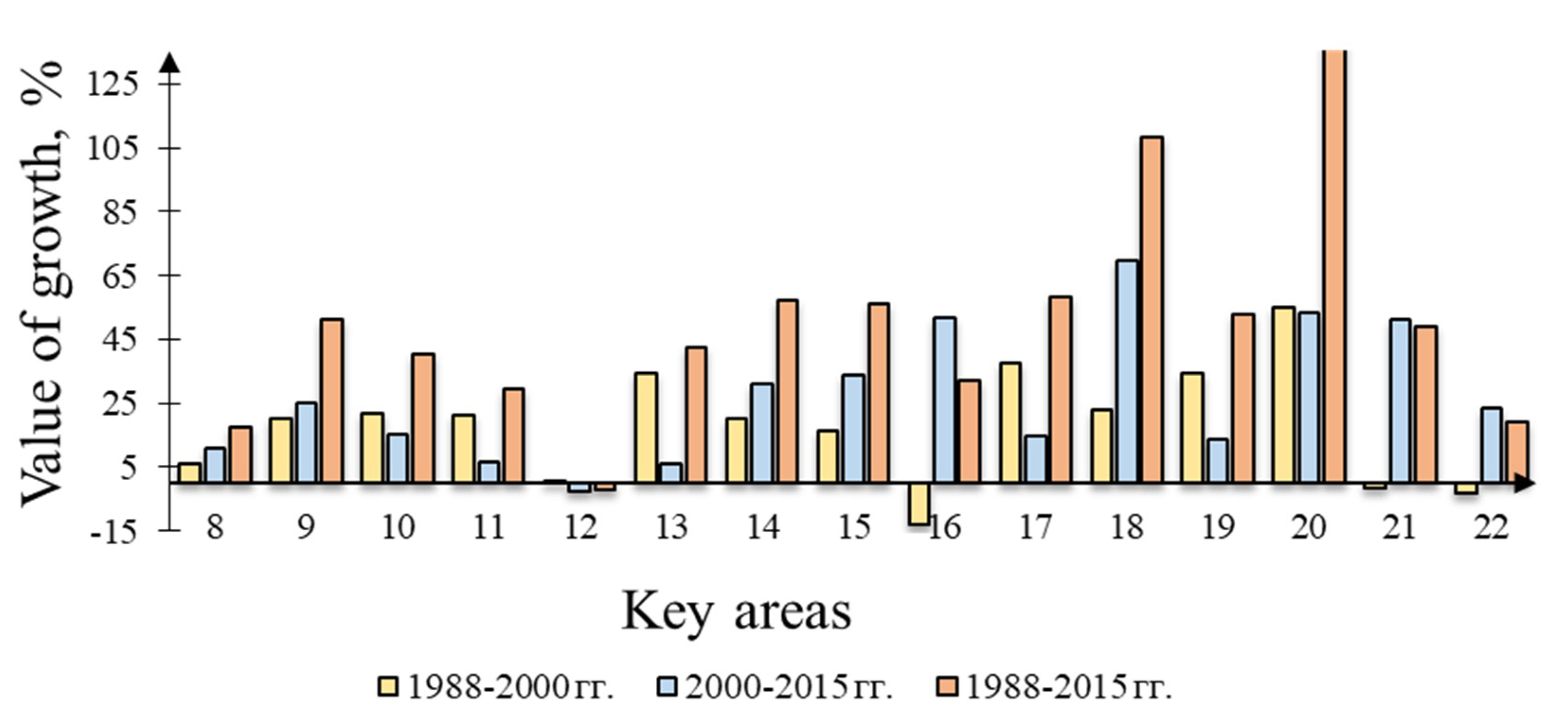
Basin of the Samara River. Here, the observations were made at 15 key interfluve areas (areas 8 to 22) for the following periods: 04/19/1988, 04/18/2000, and 04/29/2015.
The data analysis has showed that there was an increase in the quantitative parameters of the ephemeral gully network used to evaluate the quantitative parameters in almost all areas. So, the average density of the ephemeral gully network from 1988 to 2015 increased by 65%, and horizontal dissection by 50%. The main increase in the horizontal dissection and density of the ephemeral gully network is observed from 2000–2015. (
Figure 5 and
Figure 6). According to the obtained data, the average horizontal dissection and density indicators from 1988 to 2000 were increased by 8.8% and 12.9%, respectively, and by 23% and 28.4% for the period from 2000–2015. The highest values of the increase in horizontal dissection and density are observed in the area 20 (137 and 175%, respectively). The smallest dynamics was in areas No. 8 and No. 22. The negative dynamics from 1988 to 2015 has happened in the area No. 12 in terms of horizontal dissection by 2%, although the number of peaks of ephemeral gullies increased, i.e., the density of the ephemeral gully network increased to 17.7%.
The influence of the slopes exposure on the development of the ephemeral gully network intensity is estimated (
Figure 7). In the areas under study, slopes with an ephemeral gully erosion belt have two predominant exposures: southeast and northwest. The shooting time is early spring i.e., the period of formation of thawed snow. The horizontal dissection and density of the ephemeral gully network on the slopes of the southeast exposure are greater than in the northwest. This is in good agreement with the concept of the climatic type asymmetry slopes formation [
35].
Overlaying the planar ephemeral gully network image pattern related to the different times (
Figure 8) allows to determine the pattern change. The Samara river basin has a well-expressed dense ephemeral gully network, linear erosion is located in parallel series on the slopes and has a linear and dendritic pattern. The patterns overlaying also made it possible to identify the ongoing changes in the structure of the ephemeral gully network. In particular, from 1988 to 2015 there is a progression of ephemeral gully erosion in the area of the belt of sheet and rill erosion, as well as the complication of their pattern at the tops of the ephemeral gullies.
Medveditsa river basin. The dynamics of ephemeral gully erosion at 10 interfluves (areas 23 to 32) for three periods:05/03/1988–05/10/2001, 05/10/2001–05/22/2015 and 05/03/1988–05/22/2015 was studied. The general tendency during the 1988–2015 period towards an increase in the average horizontal dissection and density of the ephemeral gully network is well preserved. The rise is 56.8% and 40.3% respectively. The largest increase in the horizontal dissection and density of the ephemeral gully network is observed in the 1988–2001 period: 37.8% and 43.9%, respectively (
Figure 9 and
Figure 10). From 2001–2015 there is a slight increase in horizontal dissection (6.9%) and density (1.9%). Though in general there is an increasing trend from 1988 to 2015, however, during the period 2001–2015 there was a decrease in the horizontal dissection of the ephemeral gully network at areas No. 24, 29, 31. Also in 5 out of 10 areas the density of the network was reduced. This is an indication of the ephemeral gully network pattern simplification caused by simplification of the characteristic “plumage” on the tops of ephemeral gullies.
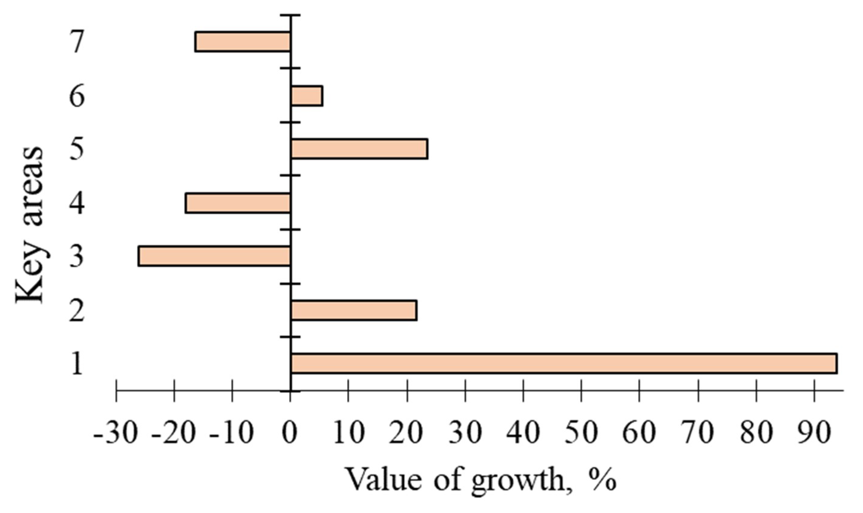
Mesha river basin. In order to assess the dynamic pattern 7 (1 to 7) key areas were selected for the period from 9 May 1988 to 29 April 2016. Intermediate images of the 2000s could not be selected due to their low quality. It can be noticed that from 1988 to 2016 the average horizontal dissection and density have increased by 5.1% and 9.8% respectively. The maximum values of the horizontal dissection and density of the ephemeral gully network are observed in the area No. 1. Negative values are found in areas No. 3, 4, 7 (
Figure 11 and
Figure 12).
It can be assumed that there is a quite comprehensive material being obtained from the interpretation of “Landsat“ medium resolution images which includes the dynamics of the ephemeral gully network on arable slopes in the forest, forest-steppe and steppe landscapes of the Russian Plain east part.
It was found that there are multidirectional changes in the rates of erosion-accumulation processes in the interfluve spaces. There is an increase in all quantitative indicators of ephemeral gully erosion (total length, horizontal dissection, and density of gullies) in the Samara river basin, which is located in the southeastern sector of the steppe zone, for the period from 1988 to 2015. Moreover, a larger increase was noted during the period from 2000 to 2015. It should be noted that the images taken during the melt runoff period were interpreted. In general, this does not mean that the growth of the ephemeral gully network was formed only due to meltrunoff.
However, it should be taken into account that some of the ephemeral gullies that are well identified in the images immediately after their formation after snowmelt can then be completely plowed during spring tillage. This explains the reason that in several areas, periods alternate with a reduction and increase in the length and density of the ephemeral gully network. At the same time, during the formation of large ephemeral gullies with a depth of up to 1 m, linear depressions are well expressed in the relief, which are spectrally well manifested in the images due to changes in soil moisture and color. The findings do not show the increase in the ephemeral gully network in areas located in the Medveditsa (border of the steppe and forest-steppe zones) and Mesha (border of the forest-steppe and forest zones) river basins. There is a substantial increase can be noticed in the area 31 only (Mesha river basin), while in most other areas in these basins there are multidirectional trends in the development the ephemeral gully network. The reduction of the network may be associated with the formation of relatively small erosions, which are subsequently plowed with regular plowing. It should be noted that in the Samara river basin in different areas there is a large variability of the ephemeral gully network indicators. This generally reflects the spatial uneven development of erosion processes on arable land associated with the multi factorial processes that determine the formation of surface runoff and runoff on slopes. At the same time it can be assumed there is a certain pattern in the development of the ephemeral gully network in the ephemeral gully erosion belt. Over the past 30 years, from the south of the forest sub zone to the forest-steppe and steppe, there has been a sharp increase in the density and horizontal dissection of the ephemeral gully network: an average of 4.6 and 10 times respectively. Considering the fact that the identification of the ephemeral gully network was carried out immediately after melt runoff in all areas, its impact on the increasing development of erosion in recent years can be pointed out. This finding contrast with an earlier data on a decreasing role of melt runoff in soil erosion of the east of EPR [
36]. This contradiction might be caused by the methods used to determine soil erosion: the radioisotope method, when the rate of erosion is determined by 137Cs in the soil sections of the bottoms of dry valleys, or the calculated one, by the mathematical empirical model. The assumptions and errors available in these methods are well-known. The obtained higher values of the dynamics of ephemeral gully erosion in the south of the forest-steppe and in the steppe zone, most likely, may indicate a significantly increased melt runoff here with a small thickness of snow cover. As it was noted earlier there is a high projective cover of arable land by agrocenoses and as a result poor exposure of areas and the difficulty with visual identification of ephemeral gullies. This makes the development processes of the ephemeral gully network during summer and during the period of rainfall being beyond the scope of this research. It is obvious to note that during this time, despite the protection of the soil by agricultural vegetation, new linear erosion forms arise, some of which, even when cultivating arable land in the summer-autumn period, are preserved until the snow cover is established. Therefore, the contribution of various types of sloping surface runoff to the development of the ephemeral gully network still remains debatable and requires additional research.


