Article

Risk Assessment of Rock Falls Released from the Former Quarry Near Spitz (Austria)

by
Rainer Poisel
1,*,
Nikolaus Hoedlmoser
1 and
Bernhard Grasemann
2
1
Institute of Geotechnics, TU Wien, 1040 Vienna, Austria
2
Department of Geology, University of Vienna, 1090 Vienna, Austria
*
Author to whom correspondence should be addressed.
Geosciences 2020, 10(11), 432; https://doi.org/10.3390/geosciences10110432
Submission received: 30 September 2020 / Accepted: 21 October 2020 / Published: 30 October 2020
(This article belongs to the Special Issue Rock Fall Hazard and Risk Assessment)

Abstract

:
In the former quarry near Spitz an der Donau (Austria), many rockfalls have occurred during operation as well as after closure. They have endangered a railway, the Wachau bicycle route, an important road, and the left Danube riverbank. Thus, future detachment scenarios were investigated and, in addition, weather and occurrence statistics were analyzed to determine the occurrence probabilities of these scenarios. Simulations of possible future rockslides were performed using the Distinct Element Code 3DEC in order to estimate the damage caused by these events. Based on these results, the risks of the scenarios were calculated according to the definition of risk as the product of damage and occurrence probability. By this means, the profitability of mitigation measures (e.g., a massive retaining structure fixed to the ground by bored piles) can be evaluated.

Graphical Abstract

1. Introduction

The former quarry of Spitz is situated approximately 1.5 km south-southwest of the township of Spitz an der Donau on the left Danube riverbank. The quarry often changed hands, and many rockslides occurred (Figure 1). The present situation poses a hazard of undetermined intensity to a railway, the Wachau bicycle route (300,000 users/year), a principal road as well as the left Danube riverbank. Several proposals for reducing the risk caused by the present situation have been made. However, the costs for the realization of these proposals (e.g., enclosure and coverage of the traffic routes) would be considerable [1,2].
In answer to rockfalls in 2006, a rockfall dam protecting the railway, the bicycle route, and the road and on top of it, a rockfall protection net was constructed. The probability of a car being hit by a large rockslide, however, was 2.4 × 10⁻⁴ per year (details see Section 3.4), which was not acceptable [3] (the probability of a bicyclist riding in the danger area when a rockslide occurs is smaller). Therefore, traffic lights were installed, which close all traffic routes automatically when exceptional displacements are monitored. Thus, it can be assumed that human lives are and will not be in danger. However, the material risk due to a large rockslide resulting from direct and indirect damages remained.
Therefore, a quantitative risk analysis has been performed in order to make a comparison of costs (of mitigation measures) and the benefit (risk reduction) possible. Following the definition of landslide risk as the product of the occurrence probability and the consequences, e.g., [4,5,6] the occurrence probability and the consequences have been determined numerically. The study of rockslides in the quarry since 1961 showed that all rockslides before excavation were stopped in 1997 by order of the authorities, and did not have any correlation with extraordinary precipitation but were caused by improper excavation. A rockslide 5 years after excavation stopped in 1997 occurred after a rainfall event, the return period of which was determined by statistical methods to be between 80 and 400 years. The approach to determining landslide occurrence probabilities by comparing landslide history and precipitation data were described by Fell et al. [7].
The rockslide in 2002 did not comprise the whole rock mass being undercut by an amphibolite-biotite layer forming the sliding plane of all rockslides. Calculations considering folds of the amphibolite-biotite layer in the rock mass, which did not slide down, showed that in these areas the factor of safety increased up to 1.3. The parameters of these calculations have been calibrated using the parameters of the 2002 event. Based on Gibson’s recommendations [8] regarding accepted probabilities of slope failures and based on consequence classes, a decrease of the probability of failure by a factor of 10 can be deduced when the factor of safety increases from 1 to 1.15. Thus, the failure probability (occurrence probability of the detachment) of the area, which did not slide down in 2002, was assumed to be 1/1000 years.
As described above, future rockslides can cause only loss of material values and consequences can be expressed in money per time. According to Amatruda et al. [5], consequences of landslides (“damages” respectively) can be divided into direct and indirect damages. In the case of Spitz, direct damages consist of the costs of rockslide debris removal and reconstruction of the traffic routes. There will be no social and environmental damages and, thus, indirect consequences will consist only of economic damages, such as reduction of tourism and detours of local inhabitants and of enterprises. For this reason, the travel distances (“runouts”) of two detachment scenarios have been calculated using the three-dimensional, numerical Distinct Element Code 3DEC [9]. This method has been chosen because empirical or GIS-based methods [7] would have been unable to take into account the complex spatial conditions in Spitz.
The sum of damages listed above, multiplied by the occurrence probability of the detachment of the area, which had not slid down in 2002, makes the risk of a future rockslide. The construction of a massive barrier at the foot of the quarry wall, retaining the blocks of a future rockslide, would be economical if the cost of such a structure did not exceed the risk multiplied by the life cycle of such a structure. Considerations like these make comprehensible decisions regarding the construction of mitigation measures by authorities and decision-makers possible.

2. Geological Conditions

The dominating lithology in the quarry consists of coarse-grained massif marbles with calcsilicate layers, which have been deformed under high-grade metamorphic conditions. The metamorphic layering dips consistently towards the southeast. Cm- to m-thick amphibolite layers, oriented parallel to the metamorphic layering, contains more than 50% biotite. The foliation cleavage has very high persistence and has served as sliding planes for all rockslides.
Structural measurements were complemented by a drone surveying flight and the application of Shape MetriX3D [10] in inaccessible places. Shape MetriX3D computes dip, dip direction, position, and distance of discontinuities using digital photos captured from different angles. Based on these data, three different areas could be distinguished within the quarry (Figure 2): Area-1 is mainly characterized by drag folds parallel to the strike of the slope, comprising both the foliation as well as the amphibolite layers. In Area-2, the foliation and amphibolite layers are planar. It contains the major sliding surface and the northwest–southeast striking lateral border face and dips steeply towards the northeast. Area-3 neither contains folds nor shear bands and records only uniformly southeast dipping layering.

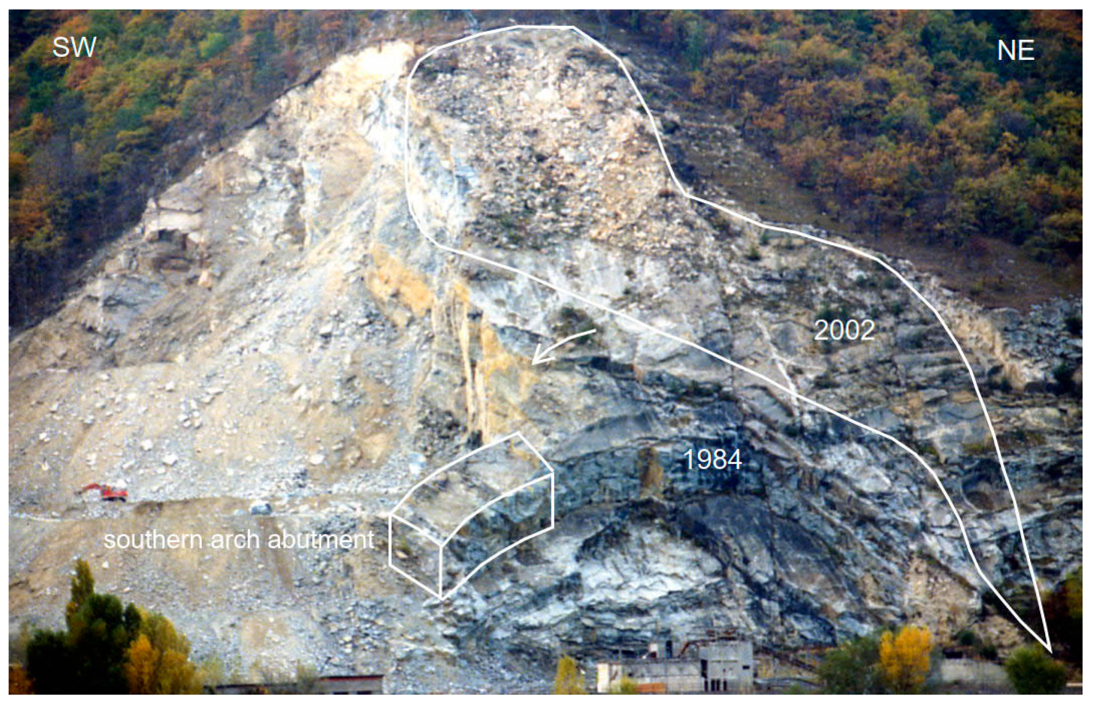
3. Rockslides Since 1961

Table 1 lists the rockslides in the former quarry of Spitz since 1961.

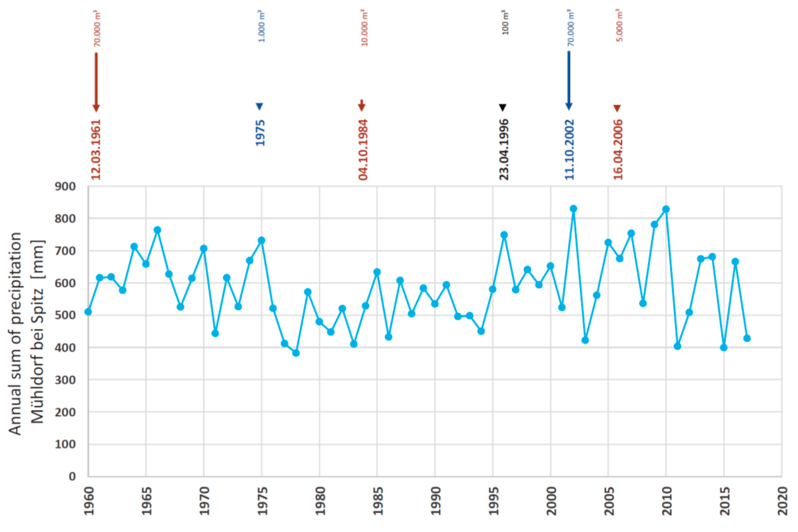
3.1. Rockslide on 12 March 1961

Excavation until 1961 produced a 180 m long, 60 to 70 m high, and 50° to 60° dipping rock face parallel to the railway undercutting an amphibolitic layer. On 12 March 1961, 70,000 m3 of marble slid down and buried the quarry bottom almost up to the railway embankment [12]. The removal of the debris unsheathed a rock arch, which most probably was produced by a former rockslide.

3.2. Rockslide on 4 October 1984

In order to avoid further foliation undercutting, the direction of excavation was changed. Now the excavation started in the valley south of the quarry in a northerly direction (Figure 3). As a result, the southern abutment of the arch formed by the former excavation was loosened and weakened and consequently failed on 4 October 1984. The rock mass lying above partly slid down but did not reach the railway.
In 1997 the authorities finally stopped the excavation, and the company went bankrupt.

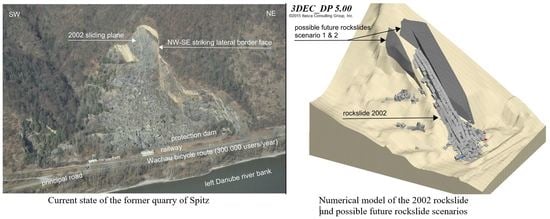
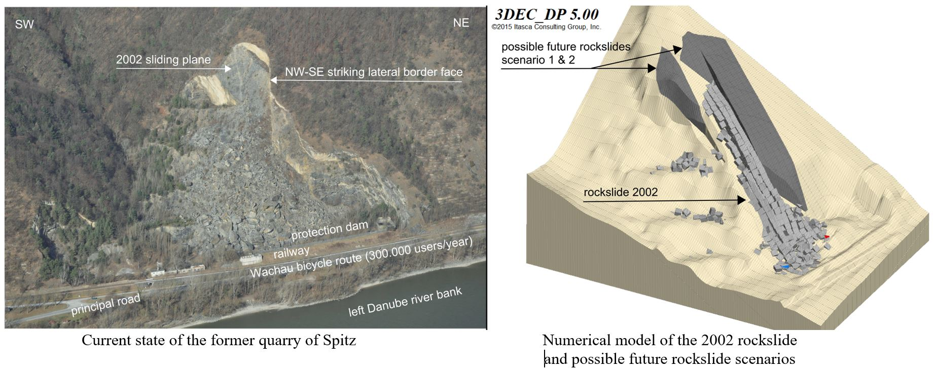
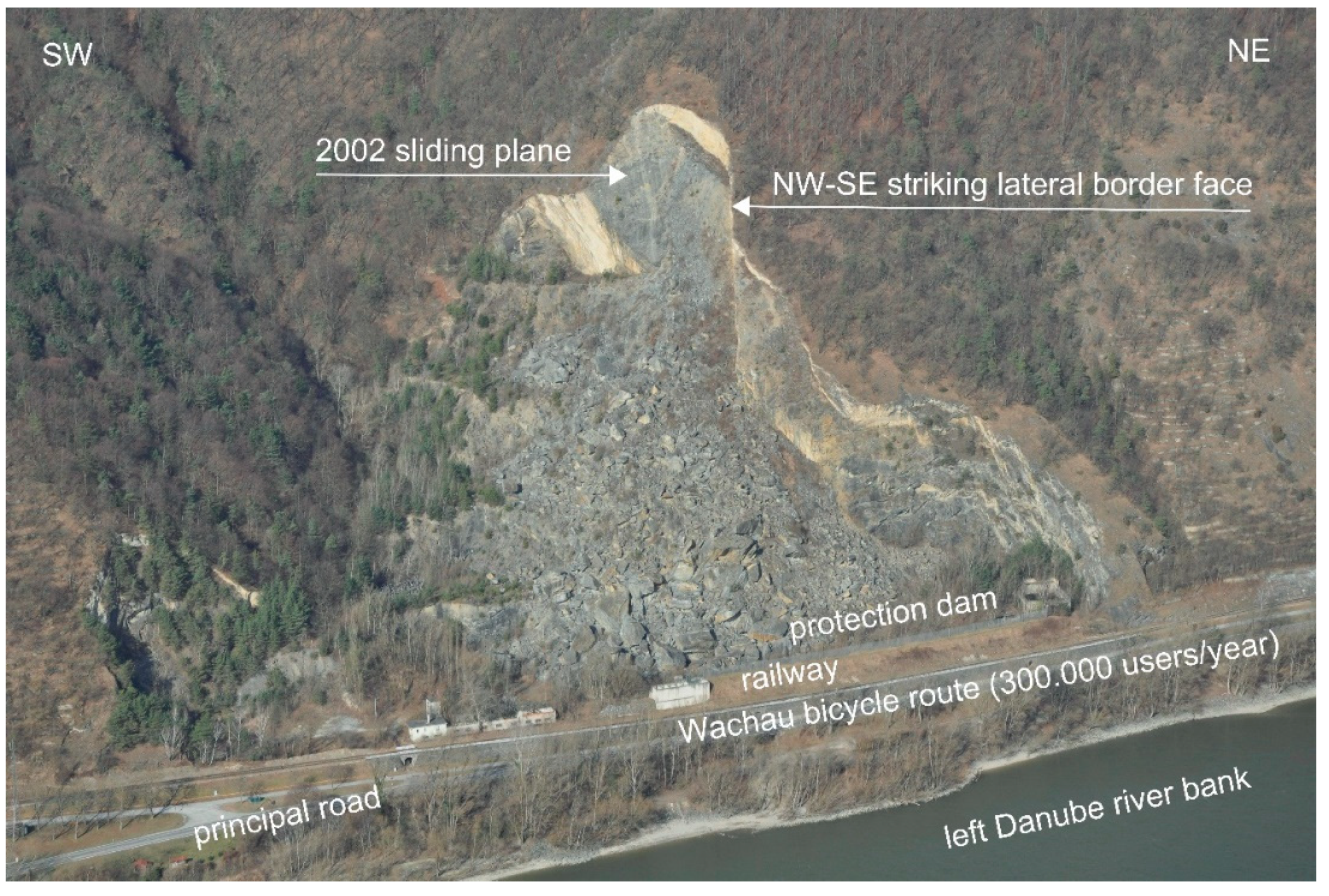
3.3. Rockslide on 11 October 2002

The rockslide shaping the present state occurred on 11 October 2002 (Figure 1). The rock mass most probably slid down on the same foliation plane, on which the 1984 slide occurred (Figure 4), with relatively low velocity. Thus, the main part of the sliding mass did not reach the railway.
The question arises, why the whole rock mass lying on an amphibolite layer did not slide down in 2002, but only the southwestern part of it. The geological investigations revealed that the foliation is strongly folded in the northeast area (area 1; Figure 2). The upper fold flanks clearly dip more gently than the foliation in the southwest area, where the 2002 rockslide took place. Thus, sliding is possible only if either the folds are sheared through or if the rock in area 1 slides on the flat (i.e., horizontal) fold flanks (Figure 5).
The influence of the folds in Area 1 on the stability of the rock masses northeast of the lateral border face of the rockslide 2002 was assessed using calculations based on the hypothesis of limit equilibrium. Using the values of the cohesion and of the angle of friction of the foliation planes back-calculated from the rockslide 2002 and assuming the strength of the marble clearly below the real strength, both calculation models showed concordantly that the factor of safety against sliding is higher than 1 northeast of the lateral border face of the rockslide 2002 and increases in a northeastern direction up to 1.3.

3.4. Rockslide on 16 April 2006

On 16 April 2006, a rock detachment with a volume of 2500 to 5000 m3 [1] occurred north of the lateral border face of the 2002 detachment (see Figure 1 and Figure 2). A comparison of laserscan data from 2005 and 2009 [13] revealed that this rock detachment was caught by the 2002 debris immediately below the rock face and remained there. This event showed that rockslides up to several 1000 m3 did not reach the toe of the blocky scree slope, and only large detachments were dangerous.
Nevertheless, because of this event, a rockfall dam protecting the railway, the bicycle route, and the road, and on top of it, a rockfall protection net was constructed. Resulting from
  • 8000 cars/day (average daily traffic, ADT),
  • 0.05 km endangered slope length (SL),
  • 24 h per day
  • 70 km/h posted speed limit (PSP) and
  • The probability of a future rockslide of 1/1000 years (PR) (details see Section 6),
the probability of a car being hit by a large rockslide P, however, amounts to
P = ADT · SL ∙ PR/24 ∙ PSP = 2.4 × 10⁻⁴ per year,
which is not acceptable [3] (the probability of a bicyclist riding in the danger area when a rockslide occurs is smaller). Therefore, traffic lights were installed, which close all traffic routes automatically when exceptional displacements are monitored. The thresholds are 10 mm (fissurometers) and 50 mm (total station). Thus far, they have not been reached since 2007 (fissurometers) [14] and since 2010 (total station) [15].

4. Precipitation Conditions

The nearest precipitation measuring station is in Mühldorf bei Spitz, where precipitation data have been recorded since 1 October 1907 [16]. Precipitation sums for 7, 30, 60, and 90 days were determined in order to assess the influence of precipitation on stability.

5. Influence of Earthquakes

According to Lenhardt [17], no earthquake has occurred, which could be linked spatially or temporally to the rockslides in the quarry.

6. Probability of Future Rockslides

Figure 6 shows the annual sums of precipitation recorded by the weather station in Mühldorf bei Spitz and the rockslides in the Spitz an der Donau quarry between 1960 and 2017.
Whereas the rockslides in 1961 and in 1984 were caused predominantly by excavation, there is a high probability that the 2002 event was caused by extreme precipitation since excavation stopped in 1997.
In 2009 and 2010, the sums of precipitation were similar to 2002, but no rockslides occurred. The return periods (annualities) of the 7-, 30-, 60-, and 90-days precipitation sums were found using statistical methods (Table 2; [18]).
It would appear to be unlikely that the 7-day precipitation alone, two months before the event, caused the rockslide. Moreover, the 90-day precipitation (507.6 mm) from 10 May to 7 August, 2010, was higher (467.1 mm) than that from 6 June to 3 September, 2002 (Table 2). However, no rockslides occurred. The 90-day precipitation, therefore, seems to be irrelevant. Thus, precipitation over a period of 30 to 60 days approximately one month before the rockslide with a return period between 80 and 400 years seems to have caused the rockslide of 2002.
Due to the high persistence of the foliation cleavage of the amphibolite layers, it must be assumed that the water filling of cleavage planes primarily induced the rockslide of 2002. Assuming that the rockslide occurred only after a cleavage plane was filled with water to the furthest downward point, the permeability coefficient amounts to 10−6 m/s, which seems to be a plausible value for a mica-rich amphibolite with cleavage planes of high persistence.
Limit equilibrium calculations have shown that the factor of safety increases in the area northeast of the lateral border face of the rockslide 2002 due to the folds in area 1 up to 1.3 (see Section 3.3). Based on Gibson’s [8] recommendations regarding accepted probabilities of slope failures and on consequence classes, the probability of failure decreases by a factor of 10 when the factor of safety increases from 1 to 1.15. This means that the probability of failure of the area northeast of the lateral border face of the rockslide 2002 is decreased from 1/80 to 1/400 years to 1/800 to 1/4000 years due to the increase of the factor of safety. In the following considerations, it is assumed that the failure probability of the area northeast of the lateral border face of the rockslide 2002 is 1/1000 years.

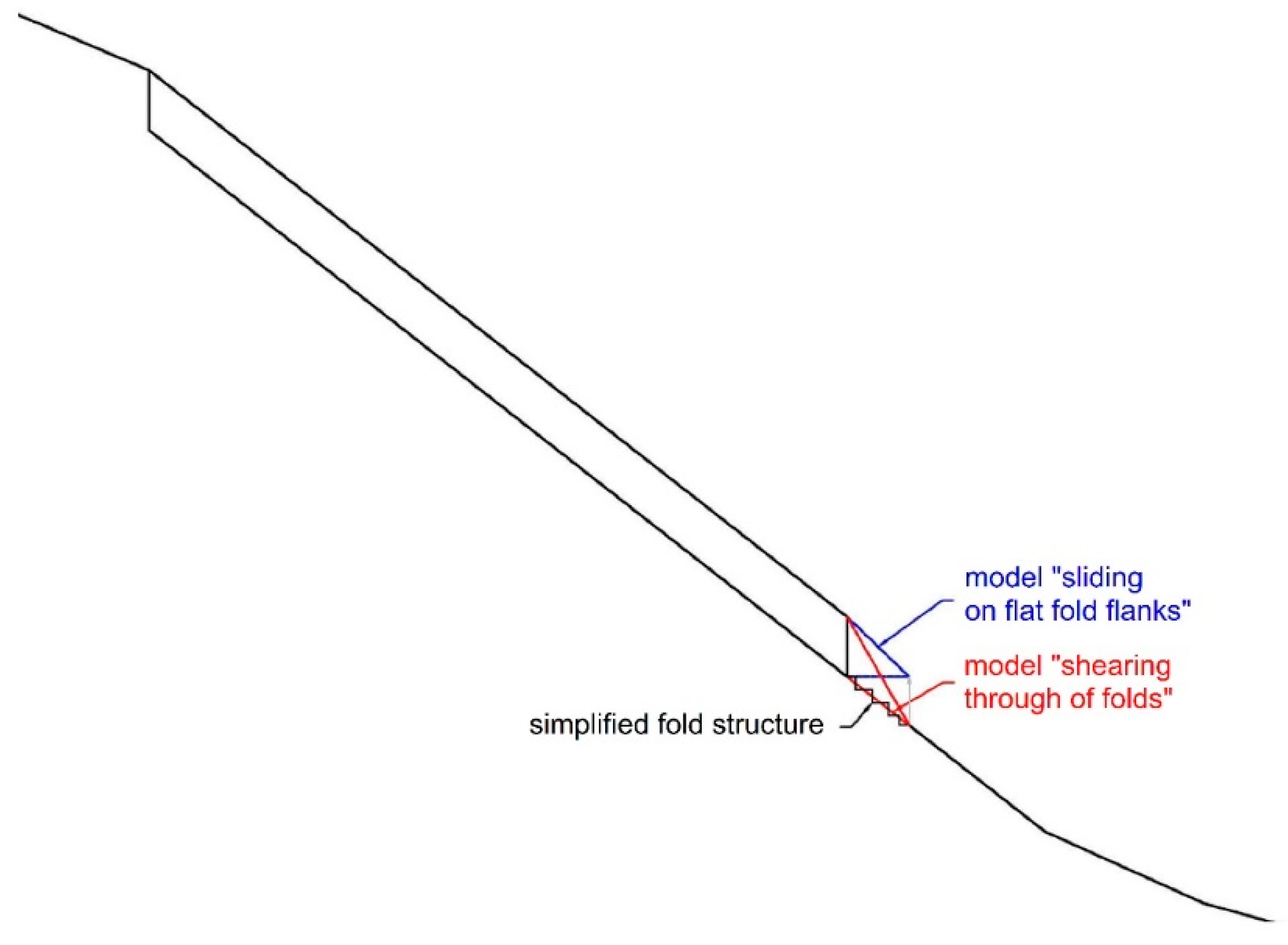
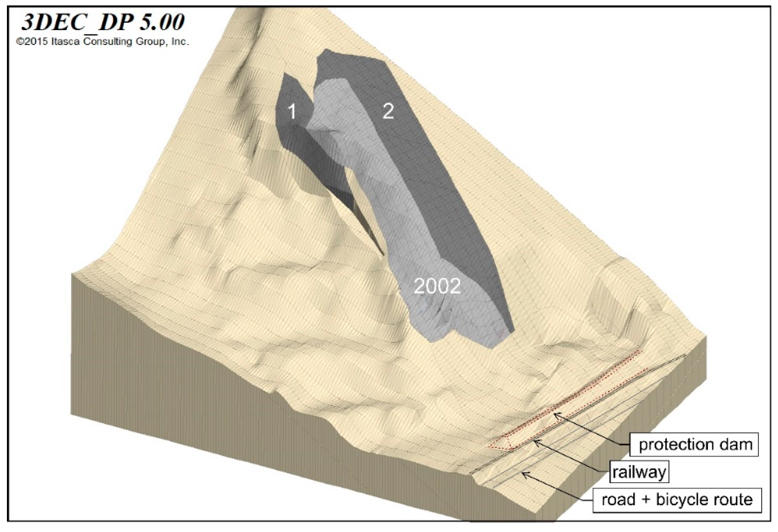
7. Possible Future Rock Detachments

At the moment, there is no evidence for determining the volumes of future rockslides such as cracks, larger displacements of particular areas, etc. Assessments of possible scenarios are based purely on knowledge of the place and experience. Experts, who have already been engaged with the former quarry, were, therefore, invited to a meeting where two detachment scenarios (Figure 7) were defined. Determinations, which are not possible on the basis of objective data, by expert-panels (“Delphi-panels“) are an approach that is chosen more and more often [19].

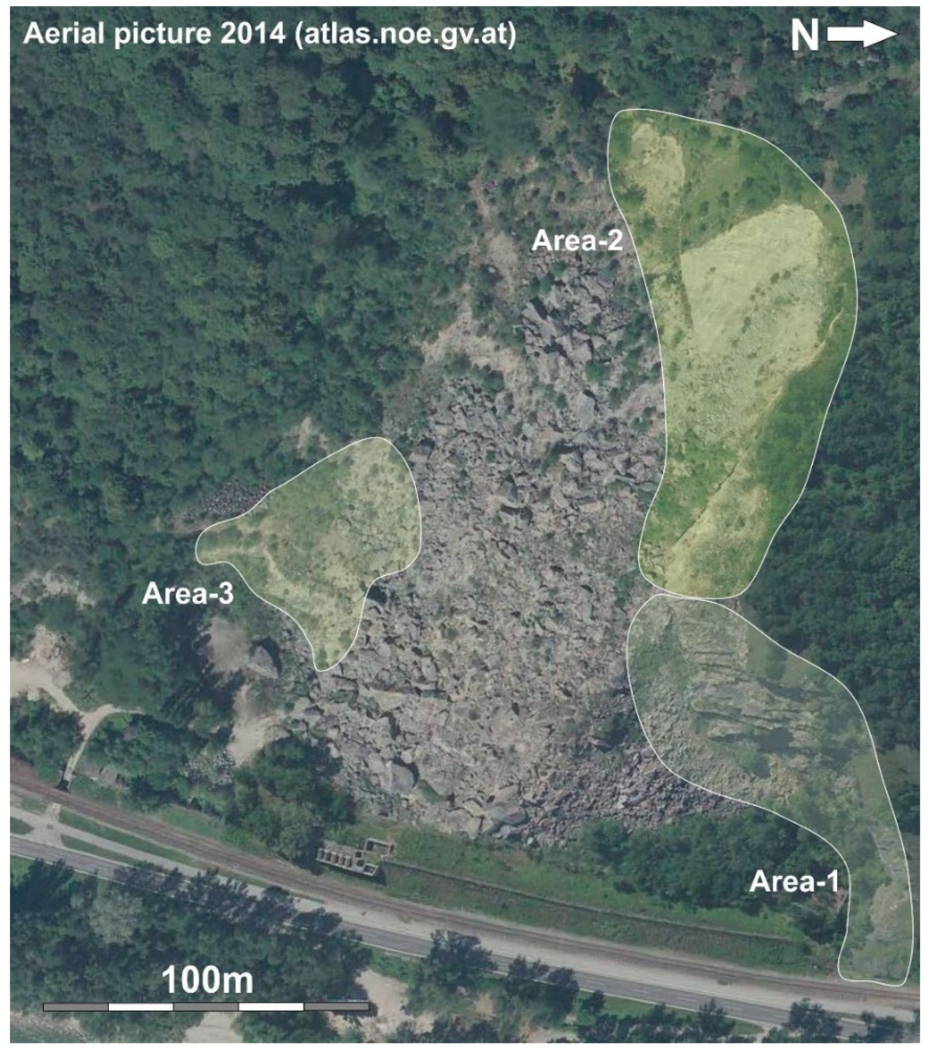
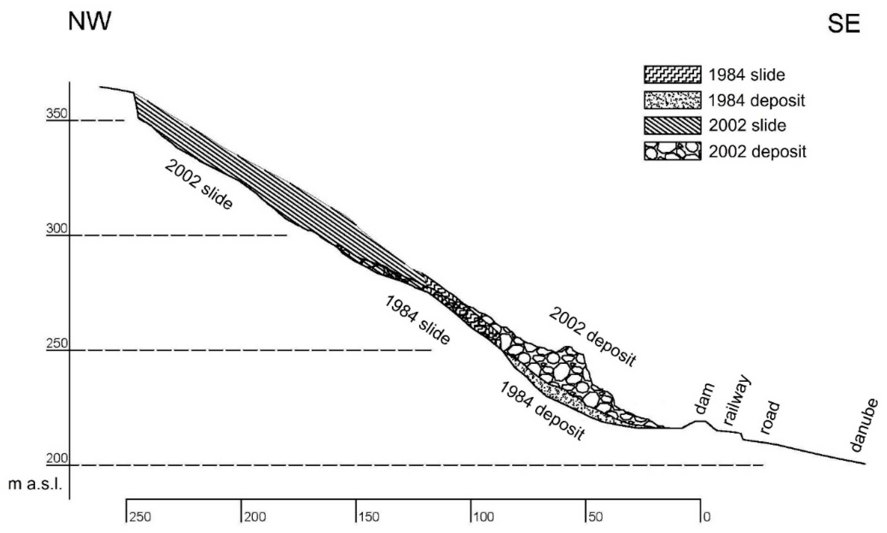
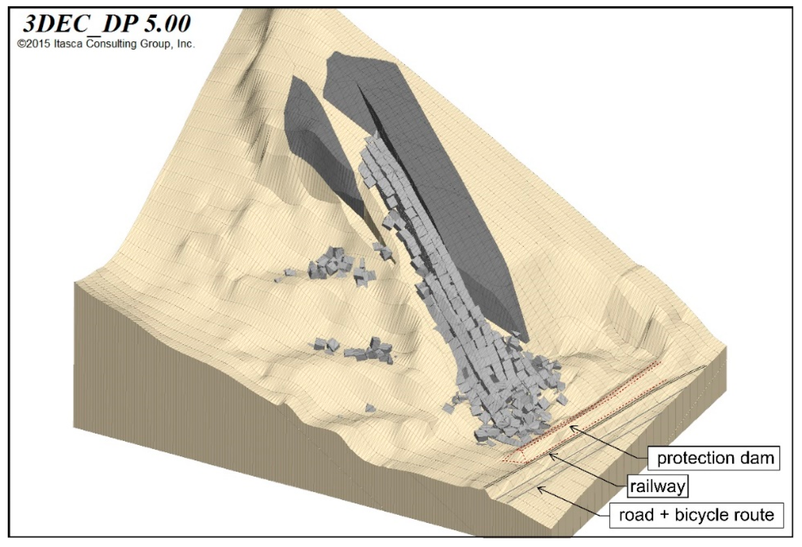
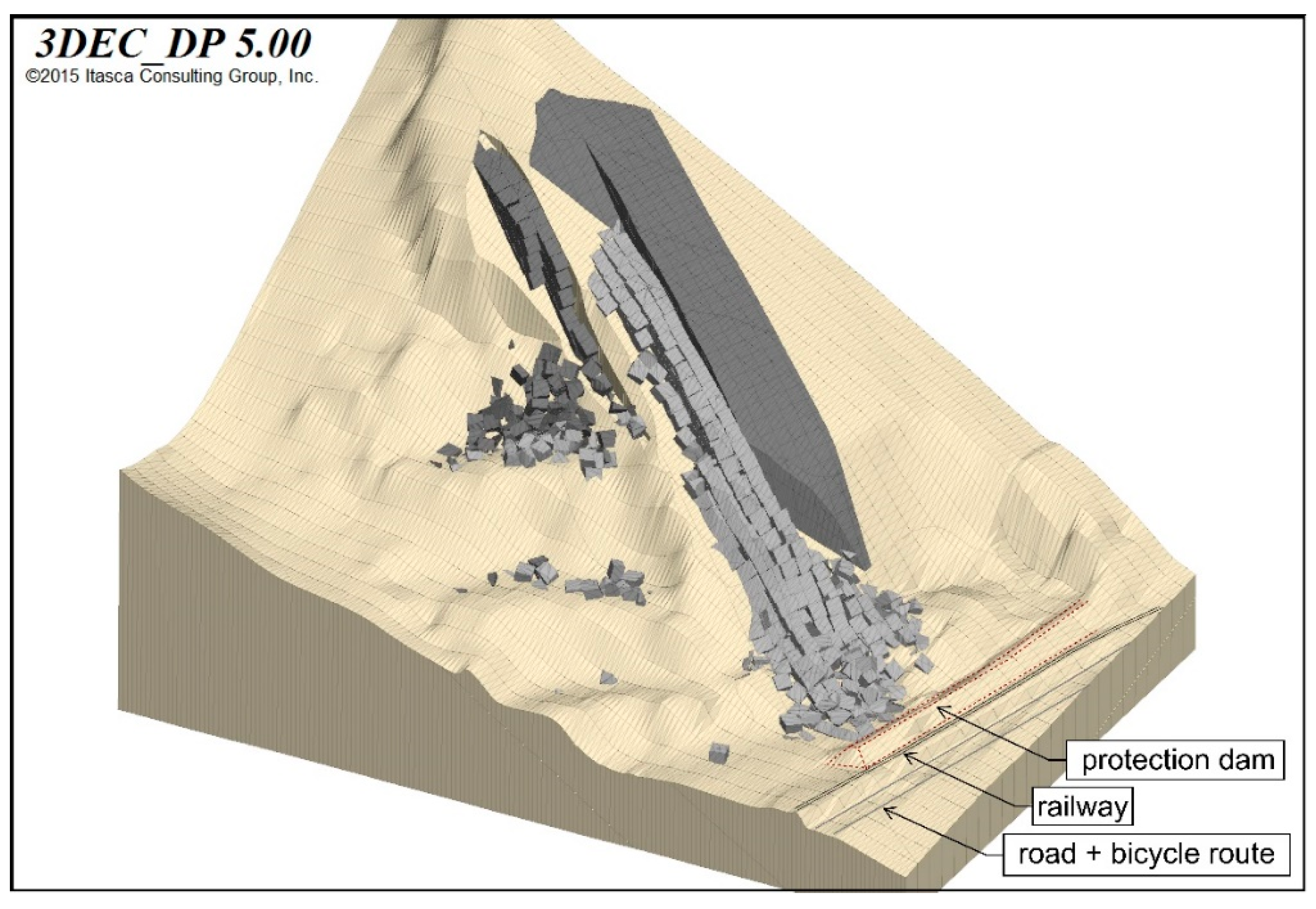
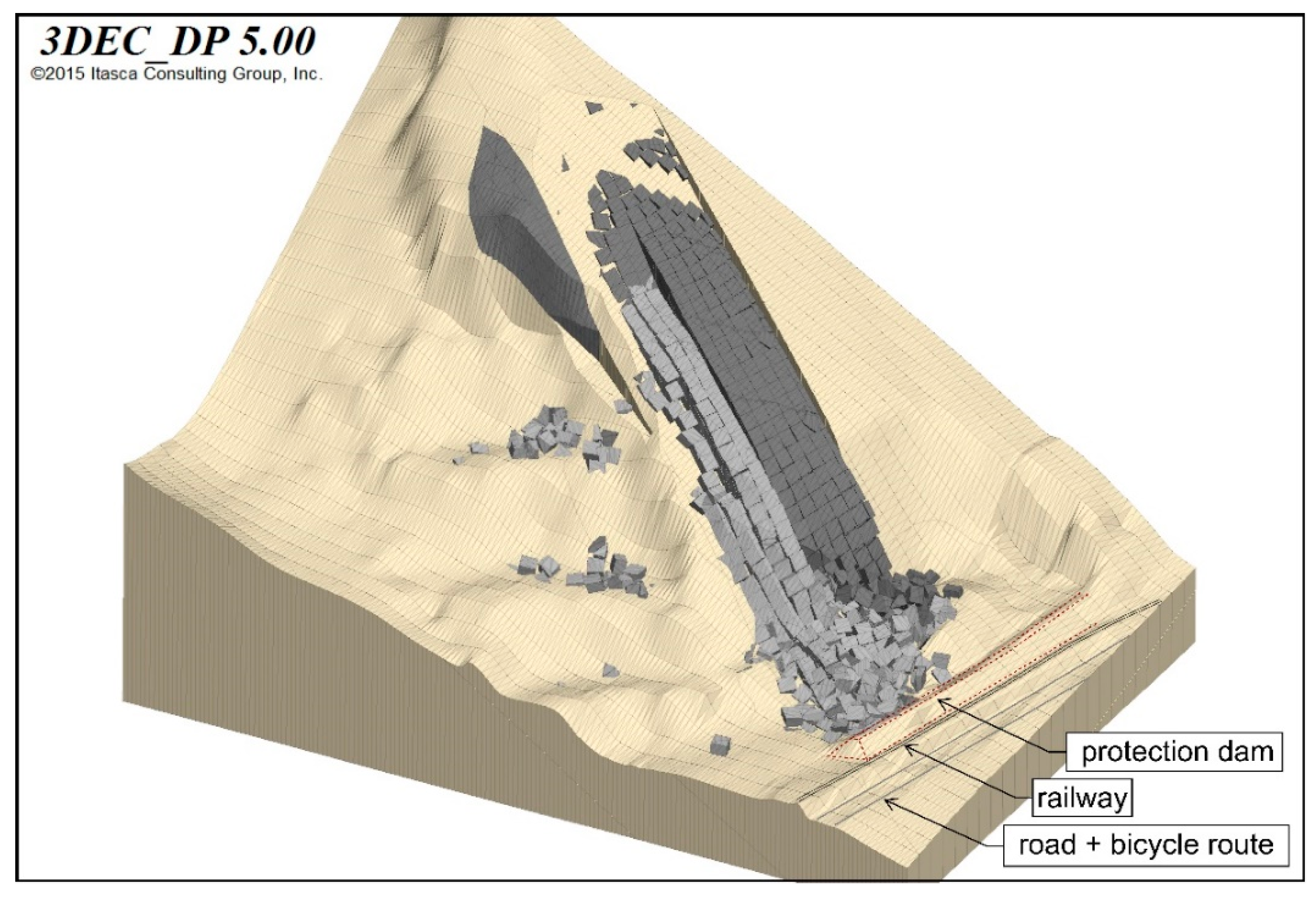
8. Deposits of Runouts of Possible Future Rock Detachments

The runouts of the detachment scenarios were simulated using the 3D Discrete Element Code 3DEC [9] because of the blocky structure of the debris. Simple 3DEC models showed that
  • Sliding of rock blocks on a discontinuity is simulated with sufficient precision, but
  • Falling of rock blocks is not simulated precisely enough because of local damping.
In the case of Spitz, however, detached rock blocks predominantly slide and, therefore, modeling using 3DEC was considered as sufficiently precise.

8.1. Simulation of Rockslide 2002

As a first step, the rockslide of 2002 was modeled to calibrate the parameters for runout simulations of possible future rock detachments. Digital terrain models (DTMs) produced during former investigations [2] helped to generate a 3DEC net, including the rock mass that slid down in 2002 as well as two detachment scenarios defined in the expert-panel (Figure 7). The light brown colored region in Figure 7 was defined as non-displaceable. The grey colored detachment scenarios were completely cut off and divided into rock blocks consistent with parameters (block size, joint orientation) measured in situ. Comparisons of simulations of the rockslide 2002 using different damping models showed that local damping provided results most consistent with conditions in reality.
Based on tilt tests in the field, analytical and simple 3DEC models as well as experience,
  • A friction angle of 26°,
  • A damping parameter of 0.35 and
  • A joint normal and joint shear stiffness of 107 Pa/m
were chosen as start values of the back analysis.
The documentation of the rockslide of 2002 and aerial photos were used to define characteristics of the deposit in 2002 (e.g., runout distance, deposit width), which the 3DEC simulations had to show. Varying the model parameters (friction angle, joint stiffness, block volume, etc.) revealed the parameters, which produced the best agreement between simulation result (Figure 8) and reality. They were:
  • A friction angle of 22°,
  • A damping parameter of 0.35 and
  • A joint normal stiffness of 107 Pa/m and joint shear stiffness of 106 Pa/m.
These parameters were then used to model Scenarios 1 and 2.

8.2. Simulation of the Runout of Scenario 1

Based on the model parameters determined as described above, the runouts of Scenarios 1 and 2 over the deposit of the rockslide of 2002 were simulated.
Modeling of Scenario 1 runout showed that the blocks stop on the former excavation benches. They do not reach the quarry bottom (Figure 9).

8.3. Simulation of Runout of Scenario 2

The simulations of the runout of Scenario 2 showed that the topography of the quarry as well as the deposit of the rockslide of 2002 would prevent most of the blocks from advancing to the existing rockfall protection dam, which has been modeled as part of the bedrock and which—in the model—was, therefore, indestructible. However, the runout of Scenario 2 would push the 2002 debris against the dam (Figure 10). The energy of this process could not be absorbed by the existing dam but would require a massive barrier connected firmly to the ground to protect the infrastructure in the quarry foreland in case of runout of Scenario 2.

9. Assessment of the Risk

9.1. Damages

Human lives will not be in danger because a signal system controlled by a monitoring system closes the traffic routes in case of large rock displacements. Therefore, damages can be quoted in terms of amounts of money.

9.1.1. Direct Damage Caused by a Large Rockslide

In the case of a large rockslide (especially runout of Scenario 2), direct damage will be the costs of removal of the rockslide deposit and the reconstruction of the traffic routes. A rough estimate of these costs amounted to about 5 Mio €, including the rock material sale proceeds.

9.1.2. Indirect Damages Caused by a Large Rockslide

According to Amatruda et al. [5], indirect damages of landslides are a result of the following consequences:
  • Social (e.g., fatalities, casualties, mental harm)
  • Environmental (e.g., vegetation damage, impact on groundwater), and
  • Economic (e.g., damages because of river impounding and of the blockade of traffic routes).
In the case of Spitz, indirect consequences mainly consist of economic damages, i.e., of the reduction of tourism for two years and detours of local inhabitants and of enterprises for the same period, because removal of the debris would take two years at least. The reduction of tourism has been derived from the decrease of overnight stays caused by a highwater event in 2013 and amounts to discontinuation of 170,000 overnight stays per year. Including daily expenses, a financial loss of about 46 Mio € in 2 years (hindrances to the rest of economic activities not included) must be assumed. The estimated cost of detours is based on the average daily traffic of about 8000 vehicles. Taking 2000 vehicles with detours of 15 km each into account amounts to a loss of 9.2 Mio € in 2 years. Thus, rough estimates of indirect consequences lead to a damage of 46 + 9.2 = 55.2 Mio €.

9.1.3. Possible Total Damage

The sum of direct and indirect damages, therefore, amounts to a possible total damage of 5 + 55.2 Mio € = 60.2 Mio €.

9.2. Occurrence Probability

The probability of runouts of areas northeastern of the rockslide 2002 due to exceptional rainfalls was derived to be 1/1000 years (see Section 6).

9.3. Risk

In the context of landslides, risk is defined as the product of occurrence probability of an event and its consequences [4,5,6]. In the case of Spitz, the consequences can be reduced to the damage expressed in amounts of money. Thus, the risk of a large rockslide in the former quarry near Spitz is
60.2 Mio € ∙ 1/1000 years = 60,200 € per year

10. Concluding Remarks

In the case of Spitz, human lives will not be in danger because a signal system controlled by a monitoring system closes the traffic routes if large rock displacements occur. Thus, decisions regarding mitigation measures in the form of the cost-benefit analyses [20] can be reduced to amounts of money. A mitigation measure in the case of Spitz could be a massive retaining structure in place of the existing protection dam fixed to the ground by bored piles. It would retain the blocks of the rockslide from pushing the protection dam aside and from burying the railway and the bicycle route, as well as the road.
Estimating the life cycle of such a structure to be about 100 years, the costs for such a structure must not exceed 60,200 € per year 100 years ≈ 6 Mio € (capitalization costs not considered) thus that the construction of a massive retaining structure would be economical. Exact cost-estimates and the final decision on how to proceed is, however, to be left to the authorities.
When human lives are in danger, the assessment of the profitability of mitigation measures must be based on the protection target (acceptable probability of fatalities) with natural hazards, which is 10−5 per year in Austria [21] and Switzerland [22].

Author Contributions

Conceptualization, R.P.; Formal analysis, N.H.; Investigation, R.P. and B.G.; Methodology, R.P.; Software, N.H.; Visualization, N.H. and B.G.; Writing—original draft, R.P. All authors have read and agreed to the published version of the manuscript.

Funding

Open Access Funding by TU Wien.

Acknowledgments

The authors gratefully acknowledge Mag. Thomas Hansmann, MAS, Head of Lower Austrian Ombudsman Office for Environmental Protection for permission to publish the investigation results, TU Wien Bibliothek for financial support through its Open Access Funding Program and three unnamed reviewers for their valuable comments.

Conflicts of Interest

The authors declare no conflict of interest.

References

  1. Alpinfra. Rockfall Spitz a.d. Donau—Technical Report upon Studies of Alternatives to ÖBB Corporation; ÖBB: Vienna, Austria, 2006. (In German) [Google Scholar]
  2. Wagner, H. Remedial Design of the Quarry Fehringer in Spitz a.d. Donau. 2006; Unpublished work. (In German) [Google Scholar]
  3. Ferrari, F.; Giacomini, A.; Thoeni, K. Qualitative Rockfall Hazard Assessment: A Comprehensive Review of Current Practices. Rock Mech. Rock Eng. 2016, 49, 2865–2922. [Google Scholar] [CrossRef]
  4. Einstein, H.H. Landslide risk assessment procedure. In Proceedings of the 5th International Symposium on Landslides, Lausanne, Switzerland, 10–15 July 1988; Balkema: Rotterdam, The Netherland, 1988; Volume 2, pp. 1075–1090. [Google Scholar]
  5. Amatruda, G.; Bonnard, C.; Castelli, M.; Forlati, F.; Giacomelli, L.; Morelli, M.; Paro, L.; Piana, F.; Pirulli, M.; Polino, R.; et al. A key approach: The IMIRILAND project method. In Identification and Mitigation of Large Landslide Risks in Europe: IMIRILAND Project; Bonnard, C., Forlati, F., Scavia, C., Eds.; Balkema: Rotterdam, The Netherland, 2004; pp. 13–43. ISBN 9058095983. [Google Scholar]
  6. Corominas, J.; van Westen, C.; Frattini, P.; Cascini, L.; Malet, J.-P.; Fotopoulou, S.; Catani, F.; Van Den Eeckhaut, M.; Mavrouli, O.; Agliardi, F.; et al. Recommendations for the quantitative analysis of landslide risk. Bull. Eng. Geol. Environ. 2014, 73, 209–263. [Google Scholar] [CrossRef]
  7. Fell, R.; Corominas, J.; Bonnard, C.; Cascini, L.; Leroi, E.; Savage, W.Z. Guidelines for landslide susceptibility, hazard and risk zoning for land-use planning. Eng. Geol. 2008, 102, 99–111. [Google Scholar] [CrossRef] [Green Version]
  8. Gibson, W. Probabilistic methods for slope analysis and design. Aust. Geomech. J. 2011, 46, 29–39. [Google Scholar]
  9. ITASCA. 3DEC: 3-Dimensional Distinct Element Code. 2016. Available online: https://www.itascacg.com/software/3dec (accessed on 21 October 2020).
  10. 3GSM GmbH. Report ShapeMetrix3D. Former Quarry Spitz/Donau. 3D—Aerial Photo Documentation for a Geological Assessment. 2016. Available online: https://3gsm.at/produkte/shape-metrix/ (accessed on 21 October 2020). (In German).
  11. NOE Atlas. Available online: https://atlas.noe.gv.at/ (accessed on 15 July 2020).
  12. Schwenk, H. Mass movements in Lower Austria 1953–1990. Jb. Geol. B.-A. 1992, 135, 597–660. (In German) [Google Scholar]
  13. Pfahler, G.; (Government of Lower Austria, Department Hydrology and Geographical Information, St. Poelten, Austria). Letter to the Authors from 24 March 2016. Personal communication, 2016. (In German). [Google Scholar]
  14. Sommer GmbH. Electronic Fissurometer Data of the Quarry SPITZ an der Donau; Sommer GmbH: Koblach, Austria, 2017. (In German) [Google Scholar]
  15. Geodata GmbH. Monitoring Data of the Quarry Spitz an der Donau; Geodata GmbH: Leoben, Austria, 2017. (In German) [Google Scholar]
  16. Government of Lower Austria, Department Hydrology and Geographical Information. Precipitation Data Mühldorf bei Spitz; Government of Lower Austria, Department Hydrology and Geographical Information: St. Poelten, Austria, 2017. (In German)
  17. Lenhardt, W.; (Zentralanstalt für Meteorologie und Geodynamik (ZAMG), Vienna, Austria). Email from 4 April 2016. Personal communication, 2016. [Google Scholar]
  18. Blöschl, G.; Viglione, A. Determination of the annualities of 7-, 30-, 60- and 90-days precipitation sums Mühldorf bei Spitz. 2017; Unpublished Report. (In German) [Google Scholar]
  19. Fell, R. Human induced landslides. In Proceedings of the 12th International Symposium on Landslides, Naples, Italy, 12–19 June 2016; Volume I, pp. 171–199. [Google Scholar]
  20. Poisel, R.; Angerer, H.; Pöllinger, M.; Kalcher, T.; Kittl, H. Mechanics and velocity of the Lärchberg—Galgenwald landslide (Austria). Eng. Geol. 2009, 109, 57–66. [Google Scholar] [CrossRef]
  21. Austrian Society for Geomechanics. Protection Target Recommendation with Gravitational Natural Hazards in Austria; Austrian Society for Geomechanics: Salzburg, Austria, 2014. [Google Scholar]
  22. Protection Target Model; Eckhardt, A. (Ed.) Nationale Plattform für Naturgefahren PLANAT: Bern, Switzerland, 2009. [Google Scholar]
Figure 1. The current state of the former quarry of Spitz.
Geosciences 10 00432 g001
Figure 2. Areas of homogenous geological structure (aerial photo from 2014; from: [11]).
Geosciences 10 00432 g002
Figure 3. Detachments of rockslides on 4 October 1984 and on 11 October 2002.
Geosciences 10 00432 g003
Figure 4. Detachments and deposits of rockslides on 4 October 1984 and on 11 October 2002.
Geosciences 10 00432 g004
Figure 5. Simplified fold structure and deduced calculation models.
Geosciences 10 00432 g005
Figure 6. The annual sum of precipitation recorded by Muehldorf bei Spitz weather station and rockslides in the Spitz quarry between 1960 and 2015 (length of arrows proportional to rockslide volume).
Geosciences 10 00432 g006
Figure 7. 3DEC net. Light grey: Detachment 2002; dark grey: Scenarios 1 and 2 defined in an expert panel; light brown: Non-displaceable ground.
Geosciences 10 00432 g007
Figure 8. Final state of 3DEC simulation of the 2002 rockslide producing the best agreement between simulation result and reality.
Geosciences 10 00432 g008
Figure 9. The final state of 3DEC simulation of Scenario 1.
Geosciences 10 00432 g009
Figure 10. The final state of 3DEC simulation of rockslide of Scenario 2.
Geosciences 10 00432 g010
Table 1. Rockslides in the former quarry Spitz since 1961.
Date [dd.mm.yyyy]Volume [m3]Cause
12.03.196170,000inappropriate excavation
1975many blocks (estimated 1000 m3)precipitation
04.10.198410,000inappropriate excavation
23.04.1996100?
11.10.200260,000–85,000precipitation
16.04.20062500–5000?
2012–2015several times some m3?
Table 2. Extreme precipitation events.
Precipitation EventReturn Period
YearDuration [days]Start [dd.mm.yyyy]End [dd.mm.yyyy]Sum [mm][Years]
200276.8.200212.8.2002256.8>1000
3014.7.200212.8.2002338.9400
603.7.200231.8.2002398.080
906.6.20023.9.2002467.135
2010715.7.201021.7.2010113.58
3015.7.201013.8.2010282.270
6012.6.201010.8.2010327.917
9010.5.20107.8.2010507.680
Publisher’s Note: MDPI stays neutral with regard to jurisdictional claims in published maps and institutional affiliations.

