

Response of Landscape Types and Shorebird Diversity to Extreme Drought Climate in Poyang Lake, China During the Non-Breeding Period
Simple Summary
Abstract

1. Introduction
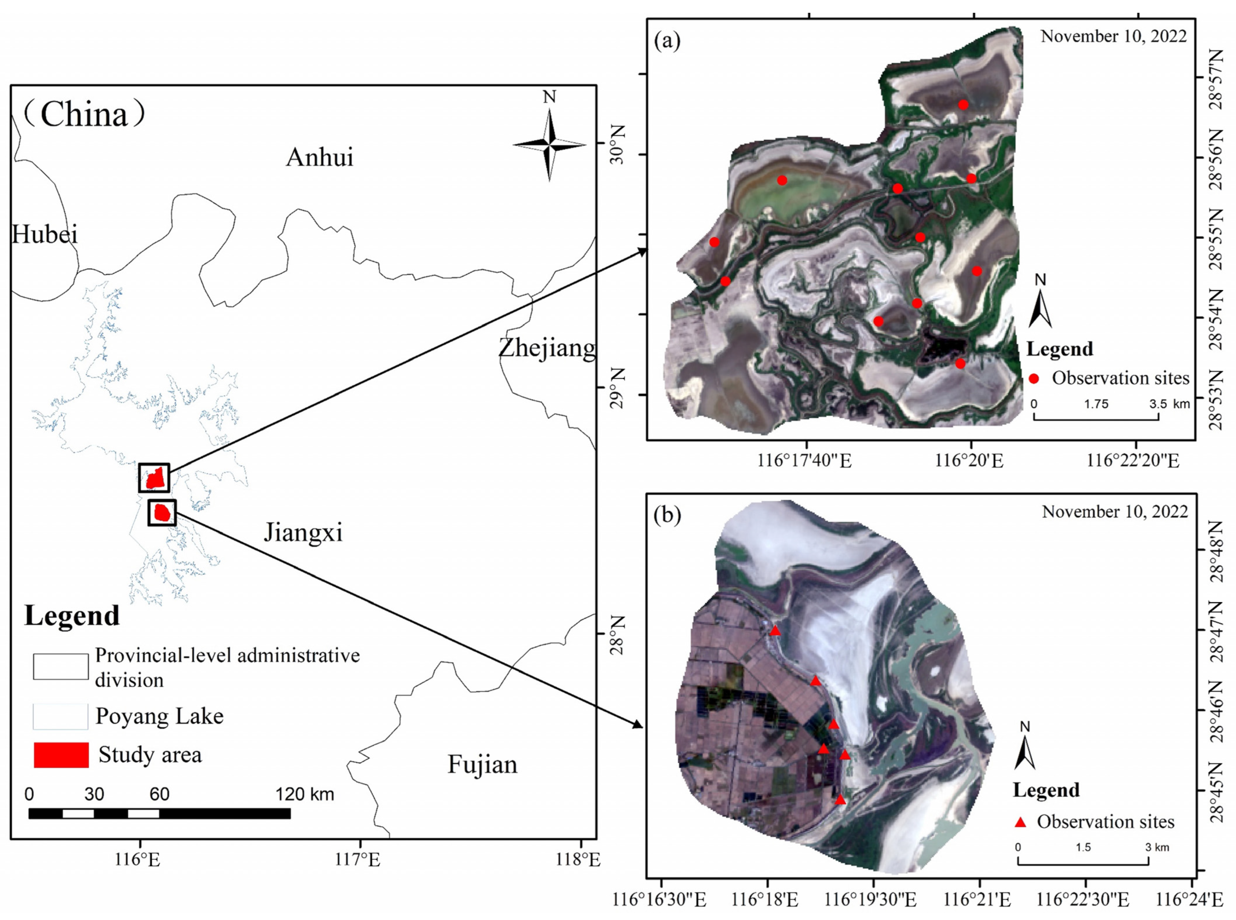
2. Study Area
3. Methods
3.1. Shorebird Survey and Data Processing
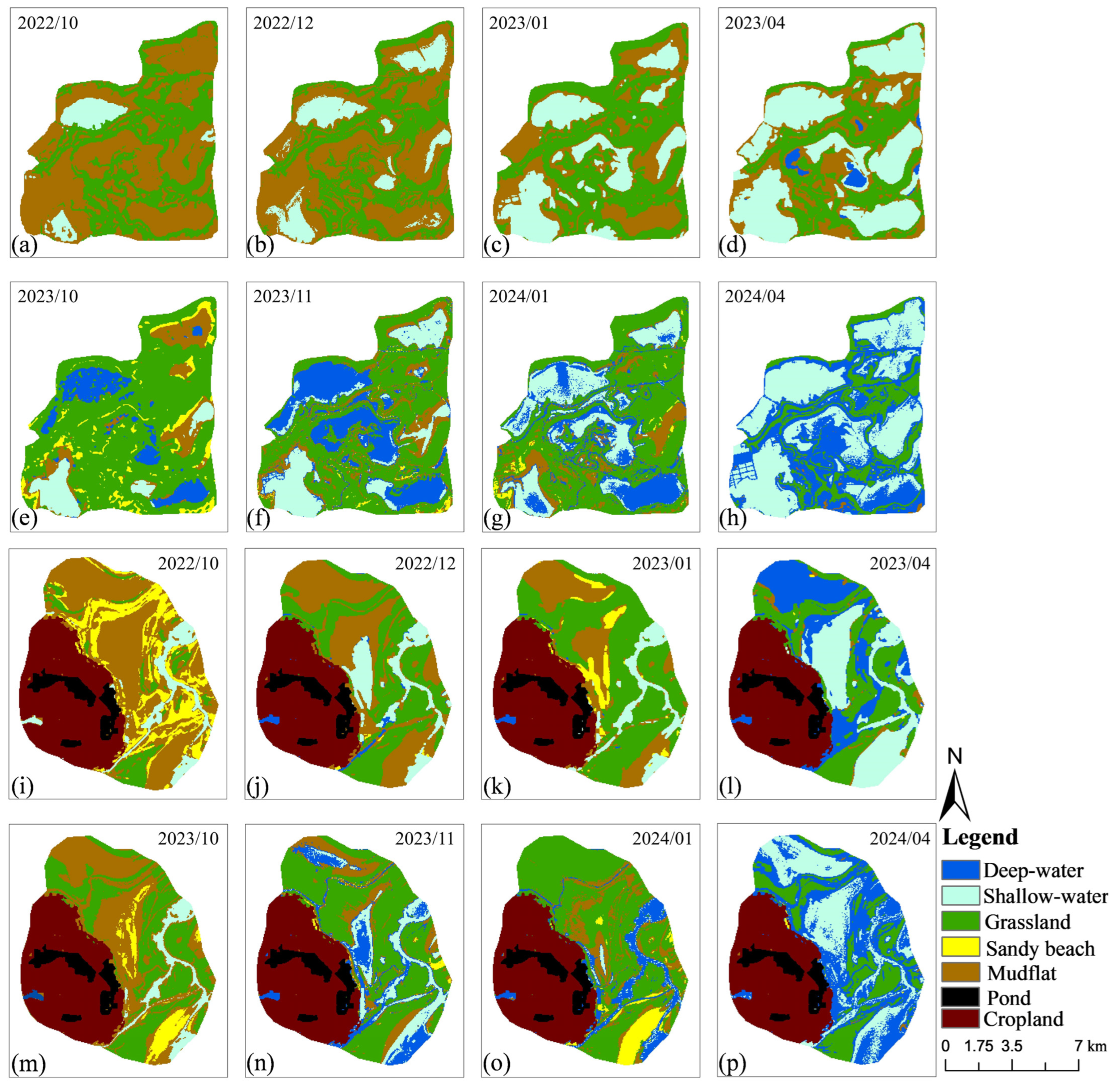
3.2. Classification of Habitat Types
3.3. Correlation of Shorebird Diversity with Landscape Patterns
4. Results
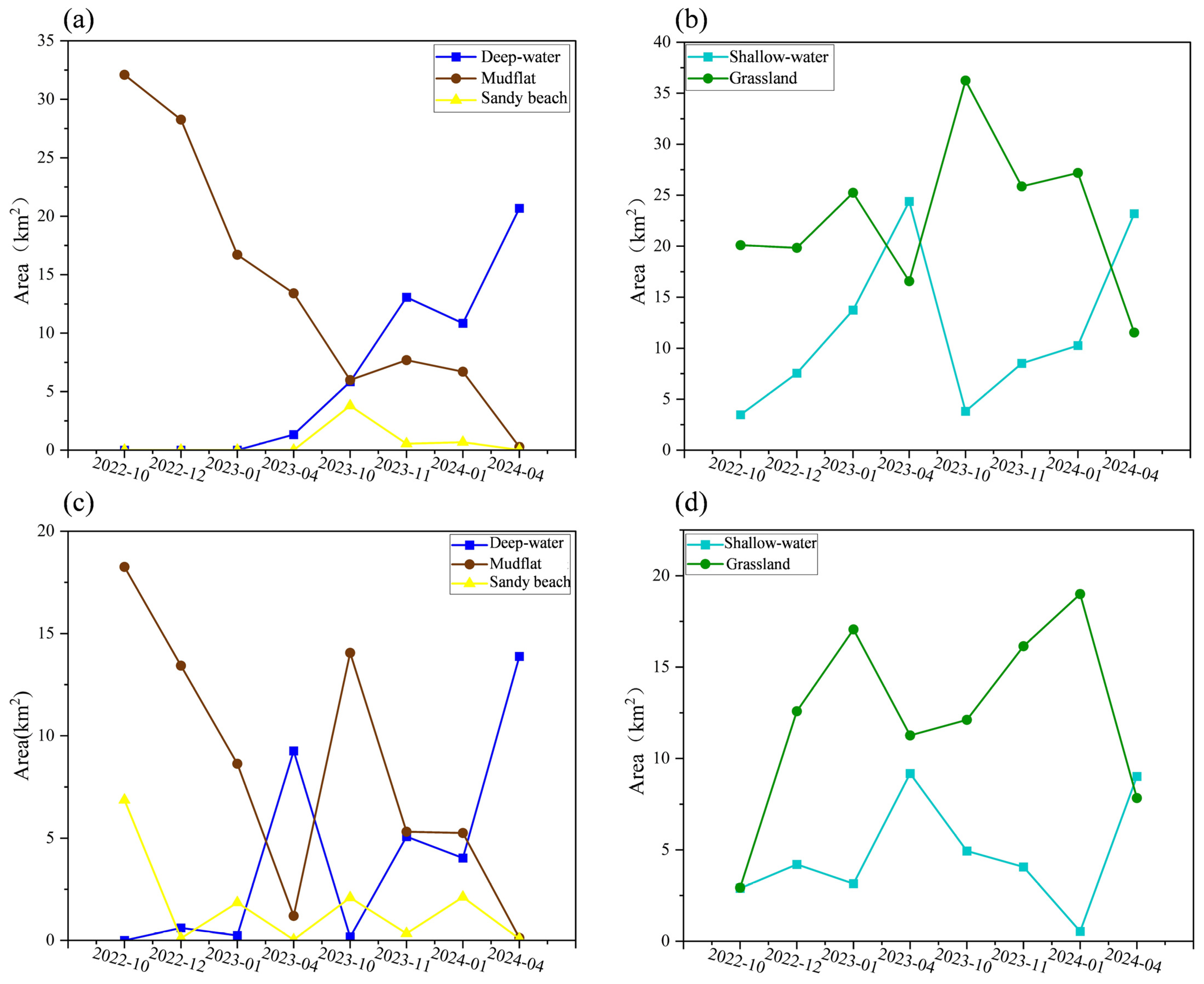
4.1. Area of Habitat Types During Extreme Drought and a Normal Water Year
4.2. Changes in Landscape Indices During Extreme Drought and a Normal Water Year
4.3. Composition of Shorebird Species in Extreme Drought and a Normal Water Year
4.4. Shorebird Diversity Parameters
4.5. Correlation Between Shorebird and Landscape Indices
5. Discussion
5.1. Landscape Characteristics and Temporal Changes in Shorebirds
5.2. Response of Shorebirds to Habitat Types and Landscape Patterns
6. Conclusions
Author Contributions
Funding
Institutional Review Board Statement
Informed Consent Statement
Data Availability Statement
Conflicts of Interest
Appendix A

| 2022–2023 | 2023–2024 | |||||||||
|---|---|---|---|---|---|---|---|---|---|---|
| Months | 9 | 10 | 11 | 12 | 3 | 9 | 10 | 11 | 12 | 3 |
| Species | ||||||||||
| I CHARADRIIFORMES | ||||||||||
| (I) Recurvirostridae | ||||||||||
| 1. Himantopus Himantopus | 64 | 22 | 3 | |||||||
| 2. Recurvirostra avosetta | 57 | 26 | 288 | 22 | 140 | 33 | 2 | |||
| (II) Charadriidae | ||||||||||
| 3. Vanellus vanellus | 52 | 499 | 1544 | 235 | 120 | 7 | ||||
| 4. Vanellus cinereus | 293 | 3 | 19 | |||||||
| 5. Charadrius dubius | 255 | 111 | ||||||||
| 6. Charadrius alexandrines | 92 | 20 | 2 | 2 | ||||||
| (III) Scolopacidae | ||||||||||
| 7. Gallinago megala | 1 | |||||||||
| 8. Gallinago gallinago | 132 | 4 | ||||||||
| 9. Limosa limosa | 5318 | 1399 | 1370 | 140 | 366 | 297 | ||||
| 10. Numenius arquata | 1562 | 1028 | 956 | 14 | 76 | 94 | 270 | 159 | 132 | |
| 11. Tringa erythropus | 134 | 49 | 2 | 30 | ||||||
| 12. Tringa stagnatilis | 162 | 183 | 7 | 2 | 4 | 22 | 83 | 2 | ||
| 13. Tringa nebularis | 773 | 16 | 1 | 32 | 3 | |||||
| 14. Tringa glareola | 1 | |||||||||
| 15. Actitis hypoleucos | 11 | |||||||||
| 16. Calidris tenuirostris | 2 | |||||||||
| 17. Calidris canutus | 1 | 1 | ||||||||
| 18. Calidris ruficollis | 21 | 5 | 2 | |||||||
| 19. Calidris temminckii | 2 | 6 | ||||||||
| 20. Calidris pugnax | 80 | 1251 | 10 | |||||||
| 21. Calidris alpina | 2 | 2 | ||||||||
| 2022–2023 | 2023–2024 | |||||||||
|---|---|---|---|---|---|---|---|---|---|---|
| Months | 9 | 10 | 11 | 12 | 3 | 9 | 10 | 11 | 12 | 3 |
| Species | ||||||||||
| I CHARADRIIFORMES | ||||||||||
| (I) Recurvirostridae | ||||||||||
| 1. Himantopus Himantopus | 4 | |||||||||
| 2. Recurvirostra avosetta | 1 | 18 | 8 | 34 | 68 | |||||
| (II) Charadriidae | ||||||||||
| 3. Vanellus vanellus | 280 | 35 | 80 | 11 | ||||||
| 4. Vanellus cinereus | 3 | |||||||||
| 5. Charadrius dubius | 1 | 30 | 3 | |||||||
| 6. Charadrius alexandrines | 8 | 1 | ||||||||
| (III) Scolopacidae | ||||||||||
| 7. Gallinago gallinago | 5 | |||||||||
| 8. Limosa limosa | 160 | |||||||||
| 9. Tringa erythropus | 2 | |||||||||
| 10. Tringa stagnatilis | 40 | 1 | 86 | 42 | 67 | 51 | ||||
| 11. Tringa nebularis | 2 | |||||||||
| 12. Tringa ochropus | 2 | 7 | 41 | 2 | 2 | |||||
| 13. Tringa glareola | 4 | 129 | ||||||||
| 14. Actitis hypoleucos | 2 | 1 | ||||||||
| 15. Calidris canutus | 1 | |||||||||
| 16. Calidris temminckii | 2 | |||||||||
| 17. Calidris pugnax | ||||||||||
| 18. Calidris alpina | 60 | |||||||||
References
- Song, X.M.; Chang, X.L.; Ding, C. Analysis of the changes in wetland landscape pattern and driving factors in the genhe basin over the past 30 years. J. Soil. Water Conserv. 2024, 38, 294–303. [Google Scholar]
- Lai, S.S.; Chen, W.B.; Wei, X.J.; Cheng, Y.Y. Prediction of nature reserves and identification of vacancy areas in Poyang Lake Basin based on ecological resilience evaluation. Chin. J. Appl. Ecol. 2024, 35, 3461–3468. [Google Scholar]
- Zhang, D.S.; Lan, Z.R.; Li, Z.; Zhang, W.; Zhong, W.J. Analysis system of spatio-temporal evolution information of the Minjiang River Estuary Wetland based on ComGI. Wetl. Sci. 2007, 5, 221–226. [Google Scholar]
- Zhang, M.; Gong, Z.N.; Zhao, W.J.; Duo, A. Landscape pattern change and the driving forces in Baiyangdian wetland from 1984 to 2014. Acta Ecol. Sin. 2016, 36, 4780–4791. [Google Scholar]
- Zhang, Q.; Ma, K.M.; Li, J.Y.; Zhang, Y.X. The effect of stopover wetlands on migratory waterbirds at different scales: A review. Acta Ecol. Sin. 2017, 37, 2520–2529. [Google Scholar]
- Chen, L.G.; Chen, L.M.; Jia, J.W.; Xu, Y.F.; Luan, Z.Y.; Shi, Y. Quantitative effects of water level variation on the habitat area of wintering waterfowl in dry season of the Poyang Lake. J. Hydraul. Eng. 2019, 50, 1502–1509. [Google Scholar]
- Chen, X.T.; He, B.F.; Huo, Y.F.; Zhang, H.Q.; Liu, H.M.; Xun, S.P. Seasonal landscape pattern changes of Shengjin Lake and its influencing factors during the wintering period of waterbirds. Resour. Environ. Yangtze Basin 2023, 32, 1653–1663. [Google Scholar]
- Tang, C.J.; Lu, J.J. A study on ecological characteristics of community of the migrating waders in wetlands insides cofferdam near the Pudong National Airport. Chin. J. Zool. 2002, 37, 27–33. [Google Scholar]
- Hou, S.L. Research progress of shorebirds. J. Anhui Agric. Sci. 2009, 37, 15873–15874, 15881. [Google Scholar]
- Chen, K.L.; Yang, X.Z.; Lu, Y. Vital stopover of shorebirds migration on the East Asian-Australasian flyway: Wetlands of Yellow Sea and Bohai Sea. Wetl Sci. 2015, 13, 1–6. [Google Scholar]
- Fang, J.Y.; Wang, Z.H.; Zhao, S.Q.; Li, Y.K.; Tang, Z.Y.; Yu, D.; Ni, L.Y.; Liu, H.Z.; Xie, P.; Da, L.J.; et al. Biodiversity changes in the Lakes of the Central Yangtze. Front. Ecol. Environ. 2006, 4, 369–377. [Google Scholar] [CrossRef]
- Rodenhouse, N.L.; Holmes, R.T. Results of experimental and natural food reductions for breeding black-throated blue warblers. Ecology 1992, 73, 357–372. [Google Scholar] [CrossRef]
- Francesiaz, C.; Yohannes, E.; Besnard, A.; Sadoul, N.; Blanchon, T.; Béchet, A. Foraging niche shift maintains breeding parameters of a colonial waterbird during range expansion. Ecol. Evol. 2020, 10, 1988–1997. [Google Scholar] [CrossRef] [PubMed]
- Hu, Y.K.; Pang, Y.W.; Jiao, S.W.; Huang, Y.X.; Xu, J.F. Temporal and spatial variative of suitable habitat for shorebird in Hangzhou Bay wetland based on remote sensing. J. Hangzhou Norm. Uni. Nat. Sci. Ed. 2019, 18, 319–328. [Google Scholar]
- Fu, M.D.; Jia, Q.; Ren, Y.H.; Zhou, H.C.; Li, J.S.; Zhang, Y.Y.; Bai, J.D.; Chen, K.L. Diversity and environmental influencing factors of curlew waterbirds in coastal wetlands of the Bohai Rim. Acta Ecol. Sin. 2021, 41, 8882–8891. [Google Scholar]
- Guo, H.C.; Shao, J.; Yang, X.L.; Xiong, B.; Li, S. Quantitative dynamic and spatial distribution of overwintering Siberian cranes in Jiangxi Poyang Lake Nanji Wetlands. Nat. Prot. Areas. 2024, 4, 88–98. [Google Scholar]
- Hu, Z. Serious drought in Poyang Lake in 2022 and countermeasures fordrought prevention and disaster reduction. Chin. Flood Drought Manag. 2023, 33, 1–6+39. [Google Scholar]
- Wang, H.Z.; Xu, Q.Q.; Cui, Y.D.; Liang, Y.L. Macrozoobenthic community of Poyang Lake, the largest freshwater lake of China, in the Yangtze floodplain. Limnology 2007, 8, 65–71. [Google Scholar] [CrossRef]
- Yan, Z.S.; Shao, M.Q.; Wang, J.Y. Prediction of suitable wintering habitat for Grus grus and key factors influencing population distribution in China. Chin. J. Appl. Ecol. 2025, 36, 578–586. [Google Scholar]
- Shao, M.Q.; Wang, J.Y.; Ding, H.X. Suitable overwintering habitat simulation and the drivers of their population expansion for Siberiancranes (Grus leucogeranus) in China. Chin. J. Appl. Ecol. 2023, 34, 1639–1648. [Google Scholar]
- Wang, J.Y.; Wang, H.X.; Shao, M.Q.; Yang, F.C.; Zeng, J.H.; Zeng, F.F. Prediction of potential distribution areas of scaly-sided mergansers, based on MaxEnt modeling, in Jiangxi Province. Chin. J. Appl. Environ. Biol. 2023, 29, 17–124. [Google Scholar]
- Zeng, N.J.; Zhu, Q.; Liu, G.H.; Yu, D.K.; Zhan, H.Y.; Liu, F.J.; Liao, B.X. A preliminary study on diversity of summer water birds in Poyang Lake area in 2015. Wetl. Sci. 2016, 14, 773–780. [Google Scholar]
- Zhi, Y.J.; Yi, J.F.; Liu, W.; Gong, H.L.; Shao, M.Q.; Dai, N.H.; Li, Q.J.; Yang, F.C. Monitoring of wintering waterbirds in the Nanji Wetland National Nature Reserve of Poyang Lake. Chin. J. Ecol. 2020, 39, 2400–2407. [Google Scholar]
- Lu, Y.H.; Weng, X.D.; Lu, P.; Di, M.X.; Zhi, Y.J.; Shao, M.Q.; Dai, N.H. The study on avian diversity of Baihe Town in Liyuzhou of Poyang Lake in Jiangxi Province. J. Jiangxi Norm. Uni. Nat. Sci. Ed. 2021, 45, 172–179. [Google Scholar]
- United States Geological Survey. Available online: http://earthexplorer.usgs.gov (accessed on 9 November 2024).
- Li, Y.Y.; Tian, J.; Liu, H.L.; Xu, W.J.; Zhou, B. Habitat needs for warders and strategies for habitat restoration. Wetl. Sci. Manag. 2020, 16, 23–26. [Google Scholar]
- Liu, L.L.; Zhu, Y.; Li, X.; Xie, D.; Wang, R.X.; Feng, Y.Q. Wintering waterfowl distribution at paddy fields in wetland park and their habitat characteristics. J. Chin. Urb. For. 2024, 22, 129–134. [Google Scholar]
- Wu, T.; Zhang, P.Y.; Zhang, S.Q.; Zou, Y.A.; Li, F.; Deng, Z.M.; Zou, D.S.; Xie, Y.H. Distribution pattern and the crucial influencing factorsof shorebirds in Dongting Lake Wetland. Res. Agric. Mod. 2023, 44, 745–754. [Google Scholar]
- Tan, F.; Zhang, M.H.; Lin, H.Y. Change and driving mechanism of suitable habitats for plover birds in Zhangjiang Estuary. J. Northeast For. Univ. 2013, 41, 89–93+149. [Google Scholar]
- Zhang, J.; Zhang, H.; Liu, Y.; Lloyd, H.; Li, J.Q.; Zhang, Z.W.; Li, D.L. Saltmarsh vegetation and social environment influence flexible seasonal vigilance strategies for two sympatric migratory curlew species in adjacent coastal habitats. Avian Res. 2021, 12, 327–337. [Google Scholar] [CrossRef]
- Li, W.; Neil, S.; Reid, J.R.W.; Matthew, J.C. Changes in distribution of waterbirds following prolonged drought reflect habitat availability in coastal and inland regions. Ecol. Evol. 2016, 6, 6672–6689. [Google Scholar]
- Barbaree, B.A.; Reiter, M.E.; Hickey, C.M.; Strum, K.M.; Isola, J.E.; Jennings, S.; Tarjan, L.M.; Strong, C.M.; Stenzel, L.E.; Shuford, W.D. Effects of drought on the abundance and distribution of non-breeding shorebirds in central California, USA. PLoS ONE 2020, 15, e0240931. [Google Scholar] [CrossRef] [PubMed]
- Huang, J.D.; Huang, J.L.; Chen, C.J. Construction of ecological network with protected areas as the main region in Guangzhou City, China. Chin. J. Appl. Ecol. 2024, 35, 247–254. [Google Scholar]
- Wang, Z.J.; Zhou, J.Y.; He, Y.; Zhang, Y.S.R.; Liu, P.Z.; Jia, Y.F.; Lu, C.; Lei, J.C. Spatially Diverse Water Levels Enhance Habitat Heterogeneity for Wintering Waterbirds. Freshw. Biol. 2025, 70, e70016. [Google Scholar] [CrossRef]
- Great River Network. Drought in Jiangxi is Greatly Relieved, but Poyang Lake Is Still at Extremely Dry Water Level. Available online: https://jxgz.jxnews.com.cn/system/2022/12/02/019867875.shtml (accessed on 2 December 2022).
- Kalu, E.I.; Reyes-Prieto, A.; Barbeau, M.A. Community dynamics of microbial eukaryotes in intertidal mudflats in the hypertidal Bay of Fundy. ISME Commun. 2023, 3, 21. [Google Scholar] [CrossRef]
- Yang, H.H.; Xu, W.Z.; Yu, J.; Xie, X.Q.; Lei, X.Y.; Wu, Z.K.; Ding, Z. Exploring the impact of changing landscape patterns on ecological quality in different cities: A comparative study among three megacities in eastern and western China. Ecol. Inform. 2023, 77, 102255. [Google Scholar] [CrossRef]
- Kalejta, B.; Hockey, P.A.R. Distribution of shorebirds at the Berg River estuary, South Africa, in relation to foraging mode, food supply and environmental features. IBIS 2008, 136, 233–239. [Google Scholar] [CrossRef]
- Hu, M.; Lu, X.; Wang, Y. The effects of spatial structure and development intensity of the urban landscape on bird biodiversity in Anhui Province. Land 2024, 13, 1660. [Google Scholar] [CrossRef]
- Zeng, J.H. Community Diversity of Shorebirds and Ecological Habits of Some Species in Poyang Lake During Non-Breeding Period. Master’s Thesis, Jiangxi Normal University, Nanchang, China, 2023. [Google Scholar]
- Zeng, J.H.; Yang, F.C.; Shao, M.Q.; Zhi, Z.Y.; He, W.Y.; Dai, N.H.; Lu, P. Diversity and annual dynamics of wintering water birds in the East Poyang LakeNational Wetland Park. Chin. J. Appl. Environ. Biol. 2021, 27, 848–854. [Google Scholar]
- Jiang, Z.; Shao, M.Q.; Wang, J.Y. Suitable overwintering areas prediction for spotted redshank (Tringa erythropus) based on Biomod2 combination model. Chin. J. Appl. Environ. Biol. 2025; accepted. [Google Scholar]
- Anderson, A.M.; Friis, C.; Gratto-Trevor, C.L.; Harris, C.M.; Love, O.P.; Morrison, R.I.G.; Prosser, S.W.J.; Nol, E.; Smith, P.A. Drought at a coastal wetland affects refuelling and migration strategies of shorebirds. Oecologia 2021, 197, 661–674. [Google Scholar] [CrossRef]
- Wang, C.; Wang, G.; Dai, L.; Liu, H.Y.; Li, Y.F.; Zhou, Y.; Chen, H.; Dong, B.; Lv, S.C.; Zhao, Y.Q. Diverse usage of waterbird habitats and spatial management in Yancheng coastal wetlands. Ecol. Indic. 2020, 117, 106583. [Google Scholar] [CrossRef]


| Landscape Index | Clarification |
|---|---|
| Patch density (PD) | PD = (NP/A) where A represents the area of the landscape or a specific type of patch; PD denotes the number of patches per unit area; and NP represents the number of patches, which reflects the degree of landscape fragmentation. The larger the PD value, the higher the degree of landscape fragmentation. |
| Maximum patch index (LPI) | (0 < LPI < 100%) where amax represents the maximum patch area of the landscape or a specific patch type, and A represents the total area of the landscape or a specific patch type; LPI reflects the dominant patch type in the landscape and quantifies the proportion of the largest contiguous patch relative to the total landscape area. It indicates the degree of continuity and fragmentation of the landscape. A value of 0% signifies the absence of large contiguous patches, while 100% indicates that the entire landscape consists of a single large patch. |
| Shannon diversity index (SHDI) | (0 ≤ SHDI) where Pi represents the proportion of the patch area of category i relative to the total area of the landscape; and n denotes the number of patch types in the landscape. SHDI reflects landscape heterogeneity; a value of 0 for SHDI indicates that the landscape consists of a single patch type, and an increase in SHDI indicates a greater level of landscape heterogeneity. |
| Perimeter-area fractional dimension count (PAFRAC) | (1 ≤ PAFRAC ≤ 2) where pij represents the perimeter of the jth patch of the ith patch type; aij represents the area of the jth patch of the ith patch type; ni represents the number of patches of the ith patch type. The closer PAFRAC is to 1, the more regular the shape of the patch, and the closer PAFRAC is to 2, the more complex the shape becomes. |
| Spreading degree index (CONTAG) | (0 < CONTAG ≤ 100) where Pi denotes the percentage of area occupied by patch type i; gik denotes the number of adjacent patches of types i and k; and m denotes the number of patch types in the landscape. CONTAG reflects the degree of aggregation or the trend of extension of patches in the landscape. A high CONTAG indicates that the landscape consists of dominant patch types with better connectivity, while a low index suggests that the landscape comprises a wide range of patch types with poorer connectivity. |
| Year | Time | PD | LPI | PAFRAC | CONTAG | SHDI |
|---|---|---|---|---|---|---|
| Extreme drought | 2022-10 | 3.718 | 27.151 | 1.342 | 47.740 | 0.859 |
| 2022-12 | 8.049 | 23.356 | 1.420 | 38.032 | 0.983 | |
| 2023-01 | 3.448 | 43.961 | 1.324 | 38.782 | 1.065 | |
| 2023-04 | 3.663 | 19.541 | 1.331 | 47.465 | 1.154 | |
| Normal water | 2023-10 | 6.555 | 63.885 | 1.314 | 55.855 | 1.122 |
| 2023-11 | 27.440 | 41.049 | 1.495 | 42.723 | 1.302 | |
| 2024-01 | 32.558 | 45.710 | 1.512 | 40.820 | 1.289 | |
| 2024-04 | 9.967 | 34.928 | 1.427 | 52.393 | 1.086 |
| Year | Time | PD | LPI | PAFRAC | CONTAG | SHDI |
|---|---|---|---|---|---|---|
| Extreme drought | 2022-10 | 6.922 | 27.847 | 1.378 | 47.663 | 1.509 |
| 2022-12 | 5.018 | 27.847 | 1.288 | 53.709 | 1.513 | |
| 2023-01 | 5.797 | 27.847 | 1.274 | 53.741 | 1.531 | |
| 2023-04 | 6.619 | 27.847 | 1.297 | 51.260 | 1.598 | |
| Normal water | 2023-10 | 5.5599 | 27.818 | 1.383 | 51.380 | 1.542 |
| 2023-11 | 19.661 | 27.847 | 1.466 | 47.178 | 1.619 | |
| 2024-01 | 21.067 | 27.847 | 1.465 | 49.517 | 1.529 | |
| 2024-04 | 11.010 | 27.847 | 1.426 | 50.113 | 1.518 |
| Nanji Wetland | Wuxing | |||
|---|---|---|---|---|
| Diversity Parameter | Extreme Drought | Normal Water | Extreme Drought | Normal Water |
| Number of species | 21 | 9 | 10 | 15 |
| Number of individuals | 18295 | 1836 | 510 | 784 |
| H | 2.53 | 2.03 | 1.80 | 2.95 |
| J | 0.57 | 0.64 | 0.54 | 0.76 |
Disclaimer/Publisher’s Note: The statements, opinions and data contained in all publications are solely those of the individual author(s) and contributor(s) and not of MDPI and/or the editor(s). MDPI and/or the editor(s) disclaim responsibility for any injury to people or property resulting from any ideas, methods, instructions or products referred to in the content. |
© 2025 by the authors. Licensee MDPI, Basel, Switzerland. This article is an open access article distributed under the terms and conditions of the Creative Commons Attribution (CC BY) license (https://creativecommons.org/licenses/by/4.0/).
Share and Cite
Yan, Z.; Shao, M. Response of Landscape Types and Shorebird Diversity to Extreme Drought Climate in Poyang Lake, China During the Non-Breeding Period. Animals 2025, 15, 1399. https://doi.org/10.3390/ani15101399
Yan Z, Shao M. Response of Landscape Types and Shorebird Diversity to Extreme Drought Climate in Poyang Lake, China During the Non-Breeding Period. Animals. 2025; 15(10):1399. https://doi.org/10.3390/ani15101399
Chicago/Turabian StyleYan, Zhongshan, and Mingqin Shao. 2025. "Response of Landscape Types and Shorebird Diversity to Extreme Drought Climate in Poyang Lake, China During the Non-Breeding Period" Animals 15, no. 10: 1399. https://doi.org/10.3390/ani15101399
APA StyleYan, Z., & Shao, M. (2025). Response of Landscape Types and Shorebird Diversity to Extreme Drought Climate in Poyang Lake, China During the Non-Breeding Period. Animals, 15(10), 1399. https://doi.org/10.3390/ani15101399