Simple Summary
Wetlands are one of the most important habitats for waterbirds. Due to the increase in human activities, waterbird habitats have been severely disturbed. Limited availability of human and natural resources makes effective habitat protection particularly important. Therefore, in this study, we developed an index system to evaluate habitat waterbird importance in Anhui Province based on habitat status. This allowed us to identify distribution and change patterns over time in important waterbird habitats. We also examined gaps in the protection of these crucial habitats and identified the key environmental influences. We found that Anhui Province has 73 important waterbird habitats, mainly concentrated in the Yangtze River floodplain. Gap analysis showed that 42 of these suffered from protection gaps, accounting for 57.53% of the total area. The importance of waterbird habitats was significantly correlated with elevation, normalized vegetation index, lake area, and lake circumference but not with distance from roads or population density. This study presents scientific information for waterbird habitat conservation in Anhui Province and provides reference cases for waterbird habitat conservation and maintaining wetland ecosystem functions.
Abstract
Wetlands are among the most important habitats of highly wetland-dependent waterbirds but are subject to ongoing habitat loss and degradation owing to intensified anthropogenic activities. The scarcity of human and natural resources makes effective habitat protection an important concern. Here, we aimed to investigate waterbird habitat protection methods for Anhui Province, China, a critical stopover and wintering area on the East Asian-Australasian Flyway that features rich wetland resources subject to significant habitat loss and degradation. We evaluated the status and importance of 306 wintering waterbird habitats and identified the key environmental influences and current protection gaps using the entropy weights method and generalized additive modeling. We found 73 important habitats for waterbirds in Anhui Province, which were classified into levels of importance (descending from I to V) according to the natural discontinuity method. Level I and Level II habitats were mainly located in the Yangtze River floodplain and Level IV habitats in the Huaihe River floodplain. The gap analysis showed that 42 important waterbird habitats had protection gaps, accounting for 57.53% of the total area. Waterbird habitat importance was significantly correlated with elevation, normalized vegetation index, lake area, and lake circumference but not with distance from roads or population density. The results of this study provide scientific information for waterbird habitat conservation planning, which is crucial for maintaining wetland ecosystem functions.
1. Introduction
Wetlands are important as habitats for wildlife and as part of natural ecosystems [1]. Different wetland habitat types attract different fauna assemblages [2]. Waterbirds as a highly wetland-dependent group depend strongly on wetland habitat quality, which can also affect the ability to maintain wildlife diversity [3]. However, wetland ecosystems are under ongoing pressure due to accelerating economic and social development as well as intensifying global climate change and human activities. Consequently, the structure of wetland ecosystems has functionally changed, and habitat changes have reduced biodiversity [4,5,6]. Pressures on waterbird survival have increased. As a result, species diversity has suffered [7].
The establishment and maintenance of protected area systems is central to regional and global waterbird conservation strategies that aim to safeguard waterbird populations against further decline [8]. The management of important waterbird habitats is, therefore, essential for the conservation of waterbird diversity and protecting wetland ecosystems. However, effective habitat conservation is challenging because of limited human and natural resources [9], which makes improvement of the conservation efficiency of habitats particularly important. To this end, habitat importance assessment and conservation gap analysis constitute applicable methods [10].
Waterbird habitat importance can be determined based on measures of community composition and structure, such as species abundance and richness. Populations of endangered and nationally protected waterbirds, such as cranes, storks and pelicans, tend to be particularly vulnerable, and their survival rates are highly dependent on habitat quality [11]. The population status of such species can, thus, be employed as an indicator in habitat importance assessment. As a number of environmental factors directly affect the survival strategies of waterbirds and determine their habitat selection [12], an understanding of the relationship between these factors and habitat importance is fundamental for devising effective management strategies [13]. A further important conservation approach is to identify protection gap areas by overlaying the distributions of important habitats and protected areas using spatial analysis tools [14,15].
Anhui Province in China is an important area for waterbirds on the East Asian–Australasian Flyway because of its amenable climate and richness in wetland resources of different types, including reservoirs, rivers, and lakes. Many waterbirds, including endangered species, such as the Siberian Crane (Grus leucogeranus), Oriental Stork (Ciconia boyciana), and Baer’s Pochard (Aythya baeri), regularly use the region as a winter stopover [16,17,18]. Anhui Province has prioritized the protection of wetlands by continuously strengthening the protection of waterbirds and their habitats; however, the protection system requires improvements because there remain unprotected or insufficiently protected waterbird habitats and protection gaps. Some waterbird habitats have also been destroyed by anthropogenic ecological pressures, such as reclamation, aquaculture, grazing, road construction, and dam impoundment [7]. Analyses of important waterbird habitats and conservation gaps in the region are, therefore, urgently required.
This study explores scientific approaches to waterbird habitat conservation, taking Anhui Province as a case study. Data obtained from waterbird surveys were used to determine their distributions, and the distribution patterns of important waterbird habitats were determined through importance assessment and overlapped with established protected areas to further assess current protection levels and identify protection gaps. The three research aims were to: (1) obtain distribution patterns of waterbirds and their temporal changes in Anhui Province, create a ranked list of important regional waterbird habitats, and generate habitat distribution maps; (2) conduct a gap analysis using GIS to clarify protection gaps and generate habitat protection gap maps; and (3) identify the environmental factors that affect habitat importance. The results of the study are anticipated to provide information for waterbird habitat conservation management and can be expanded to other regions.
2. Materials and Methods
2.1. Study Area
Anhui Province is rich in wetland resources, which are mainly distributed in the floodplains of the Yangtze, Huaihe, and Xin’an River (Figure 1). Present wetland types principally consist of rivers, lakes, marshes, and artificial wetlands. The Yangtze River floodplain mainly consists of shallow river-connected lake wetlands; those of the Huaihe River, of reservoir type wetlands; and those of the Xin’an River, of riverine wetlands. In spring and summer (wet season), aquatic plants grow strongly and accumulate rich nutrients, while in autumn and winter (dry season), the mudflats are gradually exposed, providing rich food resources for wintering waterbirds. The suitable habitat and abundant food resources make Anhui Province an important stopover and wintering location for migratory waterbirds.
Figure 1.
Study area in Anhui Province.
2.2. Data Sources and Processing
We selected 306 wetland units in the Yangtze, Huaihe, and Xin’an River floodplains, each of which was surveyed four times: July 2022 (breeding season); November 2022 (autumn migration); January 2023 (wintering); and March 2023 (spring migration). Each wetland unit (one lake or one river) was surveyed in a single day. Each floodplain was completed in 7–10 days to avoid the confounding effects of migratory movements. Each survey was conducted by 25–30 people, and individual types of wetland units were surveyed by fixed personnel to provide surveyor consistency. Surveys used the point count and line counting methods, with each survey point constituting a semicircle with a radius of approximately 500 m. The total observed coverage area of the sample points in each lake, river, or reservoir was at least 70% of the total area. The total number of waterbirds in each unit was estimated by multiplying density by area. Binoculars (8.5 × 42; Swarovski, Absam, Austria) and monoculars (ATM 20–60 × 85; Swarovski) were used for identification and counting. Direct counting was performed in areas with few waterbirds and group counting in areas with large bird assemblages [19,20]. The survey was conducted in clear, windless weather at 3 h after sunrise and at 3 h before sunset, in summer, spring, and autumn, with observations lasting approximately 15–20 min. Six types of data were selected as the factors potentially influencing habitat importance. The habitat area and perimeter were obtained using ArcGIS 10.7 (ESRI, Redlands, CA, USA). Habitat elevation (DEM) data were obtained from the Geospatial Data Cloud Platform of the Computer Network Information Center of the Chinese Academy of Sciences (http://www.gscloud.cn, accessed on 15 April 2023). Vegetation coverage (normalized vegetation index [NDVI]) and population density data were obtained from the Resources and Environmental Sciences and Data Center of the Chinese Academy of Sciences (https://www.resdc.cn, accessed on 16 April 2023). Habitat distance to roads was obtained from OpenStreetMap.
2.3. Statistical Analysis
2.3.1. Habitat Importance Assessment for Waterbirds
An evaluation index system of waterbird habitat importance in Anhui Province was constructed based on three aspects: diversity, importance, and suitability (Table 1). Seventeen indicators were used to assess these aspects, using information based on surveyed species abundance and richness, International Union for Conservation of Nature (IUCN) Red List of Threatened Species data, and national key protected species data. The entropy weights method was used to determine the weights of the indicators, resulting in an importance score for waterbird habitat for each survey period, which were summed for the total score. We then used this score to classify habitats into five levels of importance, based on the natural discontinuity grading method [21], ranging from level I (most important) to level V (least important).
Table 1.
Evaluation index system of waterbird habitat importance in Anhui Province.
The entropy weights method is an unbiased and objective information weighting model used to optimize decision making based on qualitative, quantitative, or conflicting factors [21]. It has become the main method for assessing habitat importance while avoiding the inherent subjectivity generated by human judgment by weighting indices using the natural distribution of indices [22].
2.3.2. Protection Gap Analysis
Gap analysis is a method for determining the suitability of existing biodiversity conservation systems and identifying unprotected or under-protected biodiversity components [23]. It has been widely used for the conservation of species diversity in plants [24], birds [25], amphibians [26], and endangered species [27], along with playing an important role in single species conservation [28]. We employed the method to create distribution maps of important waterbird habitats and of protected areas in Anhui Province. The superposition of spatial data and calculation of attribute data were used to identify important habitats outside the current protection range as protection gaps and characterize them [29]. In our study, we delineate wetland protection areas in Anhui Province, drawing on both national and provincial nature reserves and parks. By overlaying spatial data and analyzing attribute data for important waterbird habitats and existing wetland protection areas in Anhui Province, we identify gaps in wetland protection.
2.3.3. Analysis of Environmental Factors of Important Habitats
Generalized additive models (GAMs) can be used to explain highly nonlinear or non-monotonic relationships between response variables and environmental factors [30]. The flexibility of the fitted model can help explain complex relationships and assist in elucidating the importance of each explanatory variable. We used GAMs to model the relationship between environmental factors and waterbird habitat importance. Six environmental factors were selected: rural population density, habitat elevation (DEM), NDVI, distance from the road, lake area, and lake perimeter. Modeling was performed using the “gam” function in the “mgcv” package in R 4.1.3 software.
3. Results
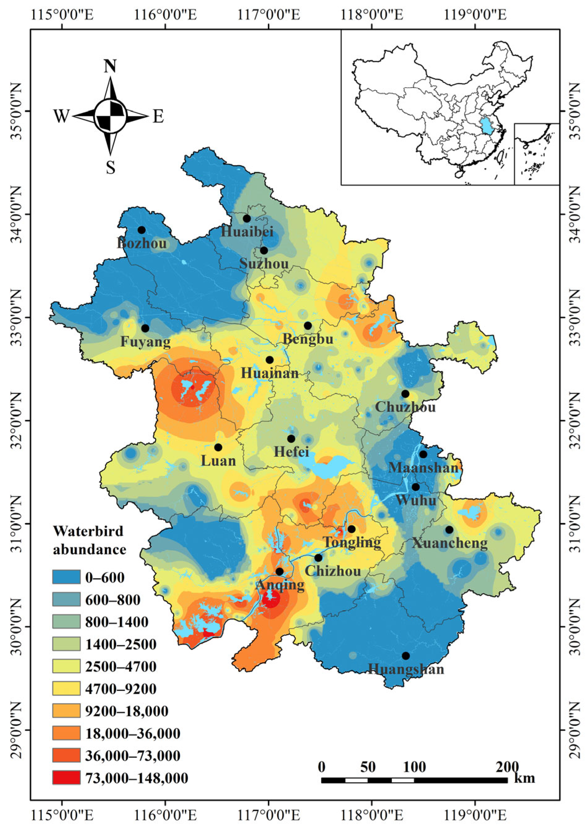
3.1. Distribution Pattern of Waterbirds
From 2022 to 2023, we recorded 1,460,875 waterbirds in Anhui Province (Figure 2). These covered 100 species from eight orders and 18 families. Of these species, 27 were national key protected species (12 first level and 15 s level species). Additionally, two globally critically endangered (CR) species (Aythya baeri and Grus leucogeranus), three endangered (EN) species (Mergus squamatus, Ciconia boyciana, and Platalea minor), nine vulnerable (VU) species, and seven near threatened (NT) species were found.
Figure 2.
Distribution of waterbird populations in Anhui Province. The displayed range represents the total waterbird abundance (individual number) in each wetland in a year. Spatial interpolation of waterbird abundance data using inverse distance-weighted interpolation in ArcGIS to demonstrate the spatial distribution of species abundance.
Surveys in the four periods showed that waterbird abundance and richness were highest in the wintering period, followed by the autumn migration period, the spring migration period, and the breeding period. National Key Protected Species abundance was highest during wintering and lowest during breeding. The abundance of CR species was highest during autumn migration, followed by spring migration, wintering, and breeding. EN, VU, and NT species abundance was highest during wintering, followed by spring migration, autumn migration, and breeding (Table 2). One must note that the spring survey migration period was longer than the autumn migration period.
Table 2.
Distribution of waterbirds in Anhui Province by the period in annual lifecycle.
Waterbird survey data were further analyzed separately for the three major floodplains in Anhui Province. Abundances at all levels were highest in the Yangtze River floodplain, followed by in the Huaihe and Xin’an River floodplains (Table 3).
Table 3.
Distribution of waterbirds in Anhui Province by floodplain.
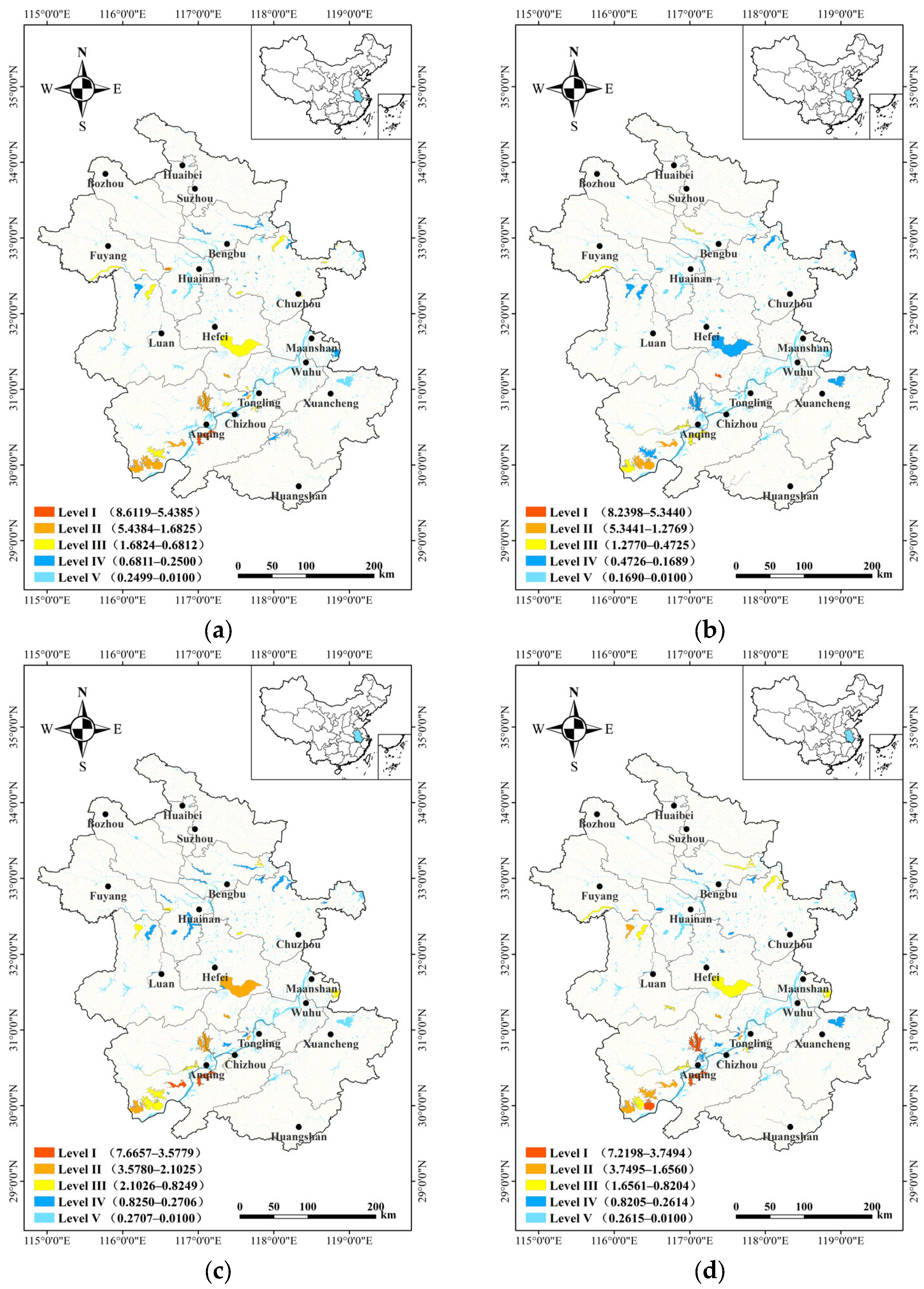
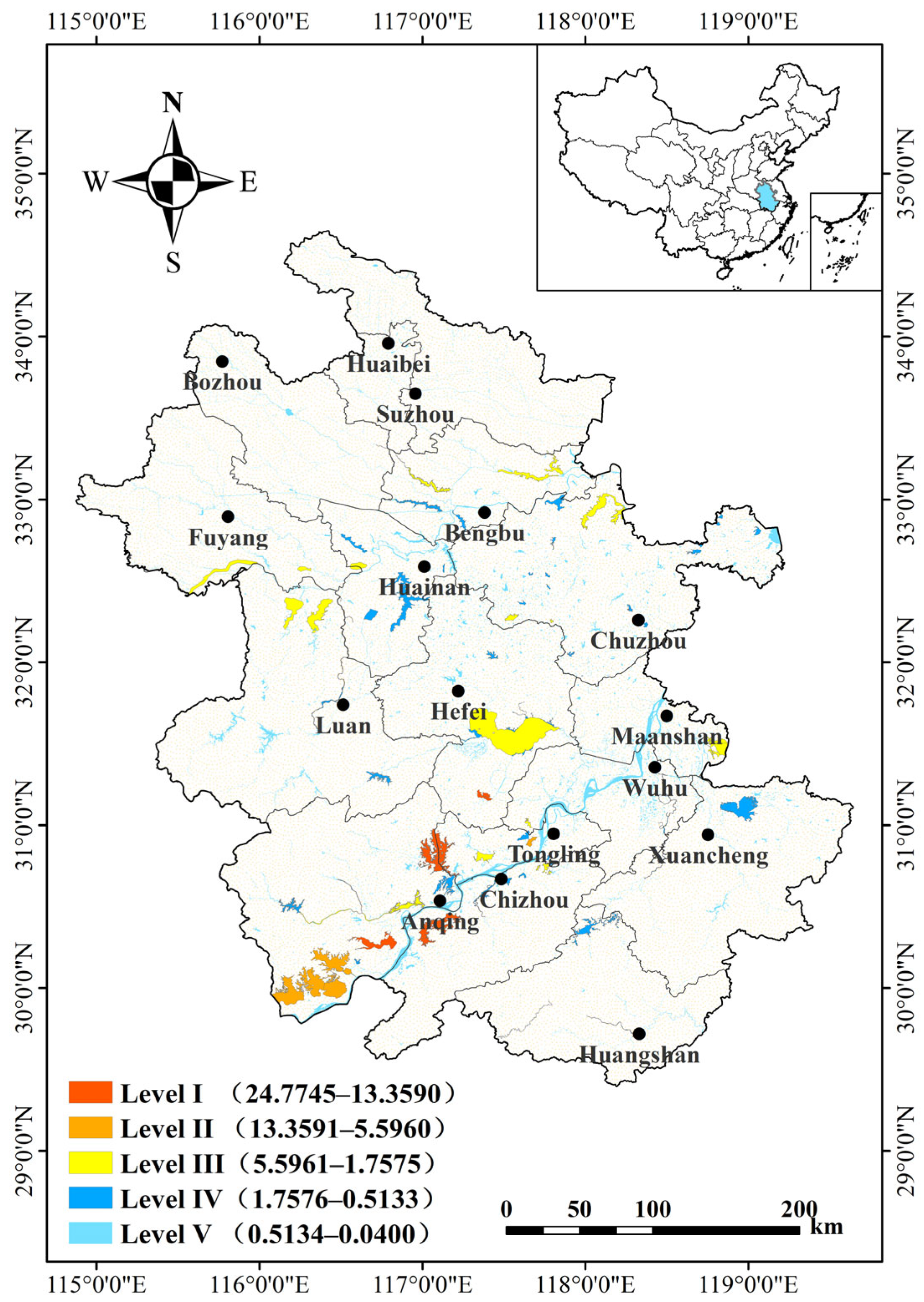
3.2. Distribution Pattern of Important Habitats for Waterbirds
Based on the survey data from the four periods, the importance of waterbird habitats in Anhui Province was assessed. A distribution map of important habitats in each period was generated (Figure 3). During wintering, 47 important habitats were identified with importance scores ranging from 0.2779 to 7.2198. Three Level I habitats were located at Shengjin (7.2198), Caizi (6.6742) and Huanghu Lake (4.9567). Additionally, 7 Level II habitats, 13 Level III habitats, and 24 Level IV habitats were identified. During spring migration, 43 important waterbird habitats were found with scores ranging from 0.2689 to 8.6119 and consisted of one Level I habitat located at Shengjin Lake (8.6119), 8 Level II habitats, 17 Level III habitats, and 17 Level IV habitats. During breeding, 41 important waterbird habitats were identified with scores ranging from 0.2044 to 8.2398. Among these habitats, one Level I habitat was located at Huangpi Lake (8.2398), along with four Level II habitats, six Level III habitats, and thirty Level IV habitats. Finally, during autumn migration, 36 important waterbird habitats were identified with scores ranging from 0.3140 to 7.2198. These habitats consisted of 2 Level I habitats located at Shengjin Lake (7.6657) and Wuchang Lake (6.3113), as well as 5 Level II habitats, 11 Level III habitats, and 18 Level IV habitats.
Figure 3.
Important waterbirds habitats in Anhui Province during the four survey periods. Classification ranges from Level I (most important) to Level V (least important). Score ranges are given in parentheses. (a) Spring migration period; (b) breeding period; (c) autumn migration period; (d) wintering period.
Importance scores summed across the duration of the entire study are shown in Figure 4. In total, 73 important waterbird habitats were found with importance scores ranging from 0.0400 to 24.7745. Score ranges per level were as follows: Level I, 24.7745–13.3592; Level II, 13.3591–5.5962; Level III, 5.5961–1.7576; Level IV, 1.7576–0.5134; Level V 0.5134–0.0400 (Table S1).
Figure 4.
Important waterbird habitats in Anhui Province based on combined scores from all four seasonal surveys. Classification ranges from Level I (most important) to Level V (least important). Score ranges are given in parentheses.
Scores for Levels I–IV ranged from 0.5342 to 24.7745 (Table 2). Level I habitats included Shengjine, Huangpi, Wuchang, and Caizi Lake, all of which are located in the Yangtze River floodplain. The six Level II important waterbird habitats identified include Huanghu, Daguan, Longguan, Chenyao, Po Lake, and Luxi River. The Luxi River belongs to the Huaihe River floodplain, while the other locations belong to the Yangtze floodplain. Of the 18 Level III habitats, 12 were located in the Huaihe River floodplain and 6 in the Yangtze floodplain. Of the 45 Level IV habitats, 23 were located in the Huaihe River floodplain, 20 in the Yangtze River floodplain, and 2 in the Xin’an River floodplain (i.e., the Hengjiang and Changjiang Rivers).
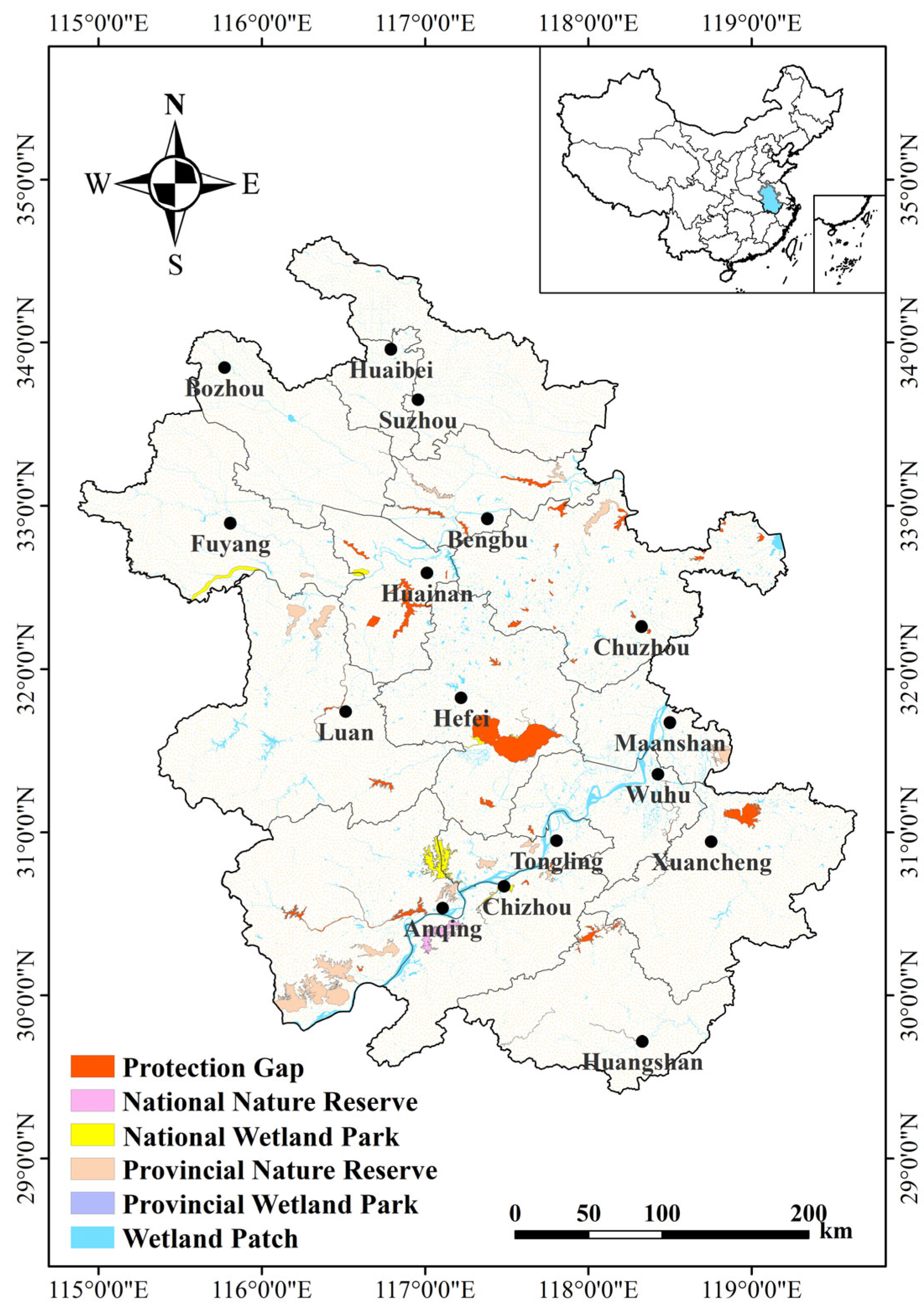
3.3. Protection Status and Gaps
A spatial overlay of important waterbird habitats and existing protected areas in Anhui Province was performed using ArcGIS to determine areas of protection gaps. A total of 42 (57.53%) of the 73 identified important waterbird habitats had no established protected areas (Figure 5). The degree of protection gaps varied by region with fewer protection gaps and higher importance indices, such as those of Huangpi and Chaohu Lake, Wanhe River, and Nanyi Lake, in the Yangtze River floodplain; in contrast, more protection gaps but generally lower importance indices, such as those of Qili Lake, Dongpi River, and Wabu Lake, in the Huaihe River floodplain, were found.
Figure 5.
Waterbird habitat protection and identified protection gaps in Anhui Province. The scope of protection is national and provincial nature reserves and parks.
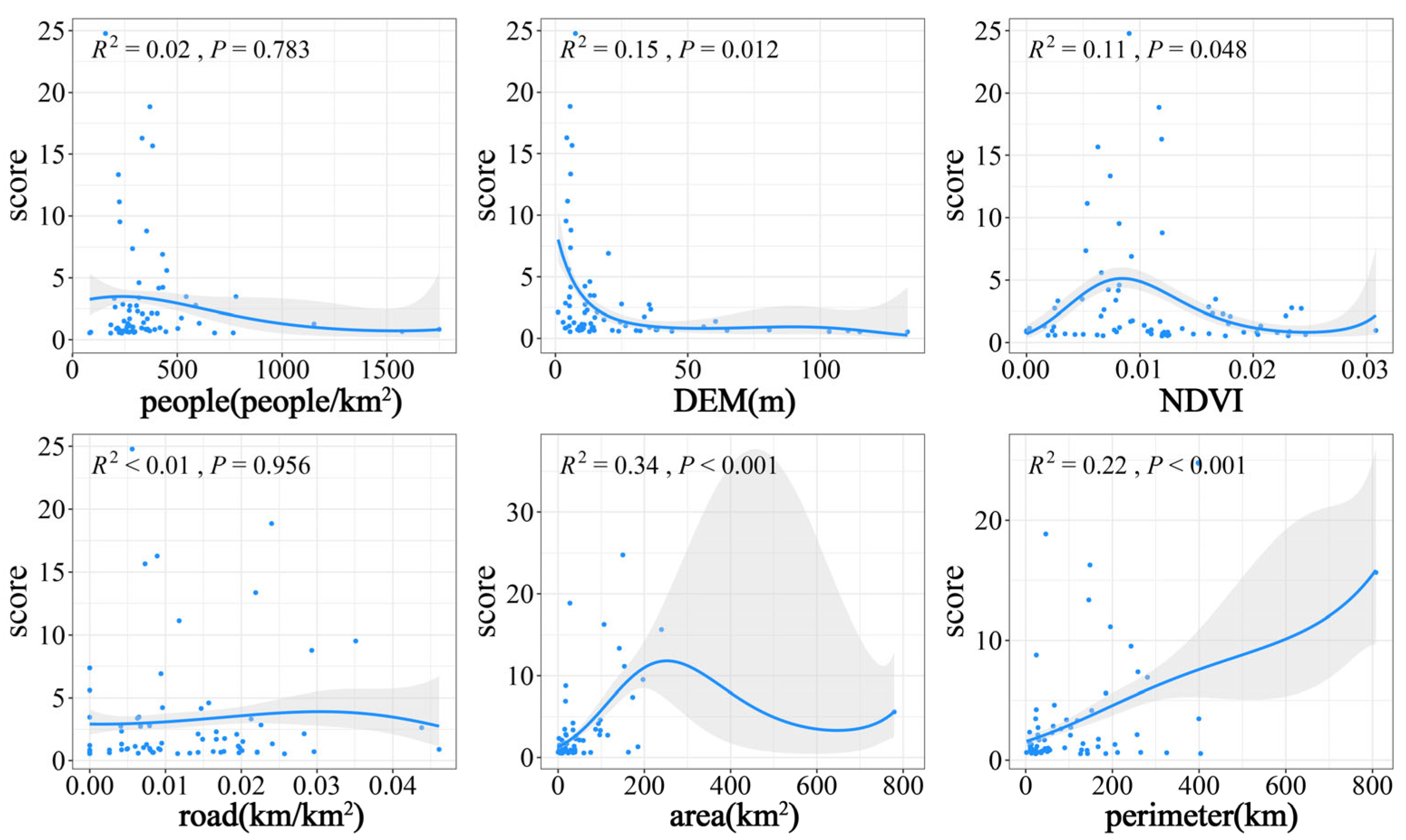
3.4. Analysis of Factors Affecting Waterbirds Habitat Importance
This study used a GAM to model the relationship between waterbird habitat importance, as assessed by field surveys. DEM, NDVI, area, and perimeter were significantly correlated with waterbird habitat importance (DEM: F1.833, 1.972 = 40.97, NDVI: F1.95, 1.997 = 22.97, area: F1.988, 2 = 141.1, perimeter: F1.853, 1.979 = 88.66; all p < 0.05), whereas road and people were not (road: F1, 1 = 0.97, p = 0.956; people: F1, 1 = 6.925, p = 0.783). DEM showed a significant negative correlation with waterbird habitat importance, while perimeter showed a positive correlation. Habitat importance had a bell-shaped relationship to both area and the NDVI, first increasing and then decreasing with increasing factor magnitude (Figure 6).
Figure 6.
Relationship between habitat importance of waterbirds and environmental factors. The gray portion indicates a 95% confidence interval. The dots represent the locations and distributions of the observed data points and the lines represent the non-linear relationships between the variables and the response variables.
4. Discussion
4.1. Distribution of Important Habitats for Waterbirds
Our study revealed the distribution pattern of important habitats for waterbirds in Anhui Province and identified areas of current conservation gaps. We further analyzed the spatial and temporal differences in the distribution patterns of important habitats for waterbirds in the province. The results show that the number of important habitats increased significantly during the wintering period and that such habitats were mostly distributed in the Yangtze River floodplain. Seasonal changes in environmental factors such as water levels and surrounding vegetation in lakes, rivers, and reservoirs result in alterations in the availability of waterbird habitats, with varying impacts on waterbird communities. During autumn, water levels tend to decline and riparian habitats gradually diversify [31]. Low water levels during winter and spring are important for the emergence, growth, and reproduction of aquatic plants. During the dry season, increases in food resource abundance and availability have been observed in habitat areas such as mudflats and grass flats [32,33], enhancing the number of foraging sites available to waterbirds [34]. Moreover, the high water level in summer promotes the growth of submerged and water-supporting plants, which provide concealment for waterbirds during surveys. Consequently, the recorded number of waterbird species during wintering, spring migration, and autumn migration was higher than that during breeding, and the important habitats for waterbirds were mostly distributed at Shengjin, Caizi, and Huanghu Lake, where water levels were low. During breeding, waterbirds were mostly found in areas with richer vegetation, such as Huangpi, Daguan, and Wuchang Lake.
The hydrological fluctuations of the shallow lakes in the middle and lower reaches of the Yangtze River were similar to those of the river itself. The water level decreased significantly during the dry season. The aquatic habitats were mainly grassy beaches, mudflats, and shallow water, and the abundant food resources were highly accessible [35]. Wetland ranges with low levels of anthropogenic disturbance constitute desirable habitats for waterbirds. However, the Huaihe River floodplain mostly features reservoir or river-type wetlands with deep water habitats or wetlands of long and narrow shapes. Moreover, most wetlands in this area are subject to anthropogenic disturbances, such as purse seine fishery, land reclamation activities, and water level control changes caused by water conservancy projects, which also negatively affect habitat availability and accessibility. Such impacted habitats reduce the ability of waterbird communities to sustain themselves and may cause wintering waterbirds to experience reduced population sizes, ranges, and species richness [36]. Therefore, the largest number of important habitats and those with the greatest importance were located in the Yangtze River floodplain, such as Shengjin, Huangpi, Wuchang, and Caizi Lake, while the Huaihe River floodplain had relatively low numbers and levels of important habitats.
4.2. Waterbird Protection Gaps
Wetlands are one of the most important ecosystems on Earth and constitute essential breeding and wintering habitats for waterbirds. As transitional ecosystems between land and water, wetlands are subject to unique environmental conditions, and the composition of waterbird communities is closely related to that of specific wetland environments. The ongoing degradation and loss of wetlands requires urgent conservation measures, among which the establishment of protected areas is one of the most effective [37]. Owing to limited human resources, an efficient combination of scientific conservation planning and effective management is necessary for the successful implementation of such conservation efforts [38]. Currently, wetland conservation primarily depends on the creation of nature reserves, with national and provincial nature parks providing additional support. This framework plays a crucial role in wetland preservation. However, certain ecologically significant wetlands remain outside these formally protected areas. For instance, Huangpi Lake is an important wetland in China and receives some level of protection, and some areas around Chaohu Lake are designated as nature reserves, but the main body is not protected. Such cases underscore the need for enhancing protection, possibly through the establishment of additional nature reserves. Gap analysis is an effective tool for accomplishing this task [39]. Gap analysis is critical to biodiversity conservation at the regional scale, using the existing protected area system to identify areas that are not or insufficiently protected and prioritize conservation targets and actions. Adaptive hierarchical management in combination with wetland status assessment can be used in this approach to identify areas with a low or insufficient protection level.
4.3. Factors Affecting Waterbird Habitat Importance
Waterbirds are highly habitat-specific, while different habitat types attract different faunal communities [40]. Habitat characteristics strongly determine waterbird species abundance and richness in a given locality. These metrics are closely related to community structure and composition, and play important roles in maintaining waterbird community diversity [36]. Vegetation is an important driver, providing food resources and hiding places; however, excessive vegetation cover can negatively affect waterbird survival [35]. Wetland area and shoreline length are strongly determinative of the extent of habitat in the fallow zone, which, as a confluence of aquatic and terrestrial ecosystems, provides a high diversity of niches and abundant food resources [13,41]. We found that all three of these factors were positively correlated with the species number and abundance of waterbirds within a certain range. Wetlands at high elevations tended to be mountainous reservoirs with predominantly deep water habitats and few food resources and were thus inhabited by fewer waterbirds, leading to a negative correlation of elevation with waterbird habitat importance [42]. Human disturbance also affects waterbird communities, directly or indirectly producing long- and short-term behavioral, physiological, and reproductive changes [43,44]. Local human population density and the vicinity of roads were thus negatively related to habitat importance [7]. These findings demonstrate that differences in habitat characteristics and the presence of anthropogenic disturbances can alter habitat selection by waterbirds, resulting in waterbird habitats of varying importance.
5. Conclusions
This study established an index system for the evaluation of waterbird habitat importance based on habitat suitability indicators, assessed and ranked the importance of waterbird habitats in Anhui Province, and generated a ranked list and distribution patterns of important habitats for waterbirds in the region. Among the 306 waterbird habitats surveyed, 73 habitats were identified as important and were further analyzed to determine seasonal distributional changes. Elevation, vegetation cover, lake area, and lake perimeter length significantly affected habitat importance. Gap analysis revealed that 42 (57.53%) of these important waterbird habitats are not currently protected. Our findings provide valuable information for the protection of waterbird habitats in Anhui Province and demonstrate the application of a data-driven approach to prioritizing waterbird habitat protection measures.
As the extent of our dynamic analysis of waterbird distributions was limited in this study, further in-depth research on the spatial and temporal dynamics of waterbird habitat importance in the region should be conducted. The NDVI is primarily a measure of vegetation cover, while waterbird habitat selection may be influenced by the diversity and availability of plant resources. However, its effectiveness as an indicator for evaluating waterbird habitat importance is limited. A more comprehensive and accurate analysis should include a combination of multisource remote sensing data and field survey data on vegetation to better assess the influence of vegetation on the significance of wetlands for waterbirds.
Supplementary Materials
The following supporting information can be downloaded at: https://www.mdpi.com/article/10.3390/ani14071004/s1, Table S1: List of important habitats for waterbirds in Anhui Province. Table S2: List of waterbirds in Anhui Province. Figure S1: Endangered waterbirds. (a) Leucogeranus leucogeranus; (b) Ciconia boyciana; (c) Aythya baeri; (d) Mergus squamatus.
Author Contributions
Conceptualization, Y.L., X.J. and L.Z.; methodology, Y.L. and X.J.; software, Y.L. and X.J.; validation, Y.L.; formal analysis, Y.L. and X.J.; investigation, Y.L.; resources, L.Z.; data curation, Y.L.; writing—original draft preparation, Y.L. and X.J.; writing—review and editing, Y.L. and X.J.; visualization, Y.L.; supervision, L.Z.; project administration, L.Z.; funding acquisition, L.Z.; All authors have read and agreed to the published version of the manuscript.
Funding
This research was funded by the National Natural Science Foundation of China, grant number 32171530, and the Anhui Provincial Forestry Bureau Epidemic Prevention and Control Special Project, grant number 2022BFAFZ00694.
Institutional Review Board Statement
This article does not contain any research involving human or animal experiments.
Informed Consent Statement
Not applicable.
Data Availability Statement
The data supporting the results of this article will be made available by the authors on request.
Acknowledgments
We are grateful to all the graduate students in our research group of Waterbird and Ecology of Anhui University for their valuable assistance with data collection.
Conflicts of Interest
The authors declare no conflict of interest.
References
- Seok, Y.; Kim, D.G.; Son, J.; Park, J.; Lee, J. The importance of the Mujechineup wetland for biodiversity: An evaluation of habitat quality and ecosystem service value. Landsc. Ecol. Eng. 2022, 18, 477–491. [Google Scholar] [CrossRef]
- Chatterjee, A.; Adhikari, S.; Pal, S.; Mukhopadhyay, S.K. Foraging guild structure and niche characteristics of waterbirds wintering in selected sub-Himalayan wetlands of India. Ecol. Indic. 2020, 108, 105693. [Google Scholar] [CrossRef]
- Kularatne, R.K.A.; Harris, J.M.; Vinobaba, P.; Thanusanth, S.; Kishoran, S.; Kankanamge, C.E. Use of habitats by aquatic and terrestrial avifauna in tropical coastal lagoons. Reg. Stud. Mar. Sci. 2021, 47, 101926. [Google Scholar] [CrossRef]
- Le Roux, J.J.; Hui, C.; Castillo, M.L.; Iriondo, J.M.; Keet, J.H.; Khapugin, A.A. Recent anthropogenic plant extinctions differ in biodiversity hotspots and coldspots. Curr. Biol. 2019, 29, 2912. [Google Scholar] [CrossRef] [PubMed]
- Teller, B.J.; Miller, A.D.; Shea, K. Conservation of passively dispersed organisms in the context of habitat degradation and destruction. J. Appl. Ecol. 2015, 52, 514–521. [Google Scholar] [CrossRef]
- Pimm, S.L.; Jenkins, C.N.; Abell, R.; Brooks, T.M.; Gittleman, J.L.; Joppa, L.N.; Raven, P.H.; Roberts, C.M.; Sexton, J.O. The biodiversity of species and their rates of extinction, distribution, and protection. Science 2014, 344, 987. [Google Scholar] [CrossRef] [PubMed]
- Mahar, N.; Habib, B.; Hussain, S.A.; Shawl, T.; Takpa, J. Influence of anthropogenic factors on the waterbirds in Trans-Himalayan wetlands. Glob. Ecol. Conserv. 2023, 46, e02567. [Google Scholar] [CrossRef]
- Jackson, S.F.; Gaston, K.J. Land use change and the dependence of national priority species on protected areas. Glob. Chang. Biol. 2008, 14, 2132–2138. [Google Scholar] [CrossRef]
- Di Minin, E.; Soutullo, A.; Bartesaghi, L.; Rios, M.; Szephegyi, M.N.; Moilanen, A. Integrating biodiversity, ecosystem services and socio-economic data to identify priority areas and landowners for conservation actions at the national scale. Biol. Conserv. 2017, 206, 56–64. [Google Scholar] [CrossRef]
- Zhao, L.N.; Li, J.Y.; Liu, H.Y.; Qin, H.N. Distribution, congruence, and hotspots of higher plants in China. Sci. Rep. 2016, 6, 19080. [Google Scholar] [CrossRef]
- Wang, C.; Liu, H.Y.; Li, Y.F.; Dong, B.; Qiu, C.Q.; Yang, J.L. Study on habitat suitability and environmental variable thresholds of rare waterbirds. Sci. Total Environ. 2021, 785, 147316. [Google Scholar] [CrossRef]
- Almeida, B.D.; Silva, C.B.; Gimenes, M.R.; dos Anjos, L. Waterbirds in a floodplain: Influence of spatial and environmental factors through time. Rev. Bras. Ornitol. 2016, 24, 314–322. [Google Scholar] [CrossRef]
- Cerda-Peña, C.; Rau, J.R. The importance of wetland habitat area for waterbird species-richness. Ibis 2023, 165, 739–752. [Google Scholar] [CrossRef]
- Christodoulou, C.S.; Griffiths, G.H.; Vogiatzakis, I.N. Using threatened plant species to identify conservation gaps and opportunities on the island of Cyprus. Biodivers. Conserv. 2018, 27, 2837–2858. [Google Scholar] [CrossRef]
- Huang, Z.Q.; Lu, L.; Dai, N.H.; Jiao, G.Y. Vacancy analysis on the development of nature reserves in Jiangxi Province. Acta Ecol. Sin. 2014, 34, 3099–3106. [Google Scholar]
- Cao, L.; Zhang, Y.; Barter, M.; Lei, G. Anatidae in eastern China during the non-breeding season: Geographical distributions and protection status. Biol. Conserv. 2010, 143, 650–659. [Google Scholar] [CrossRef]
- Liu, X.Y.; Zhang, Z.X.; Zhang, J.M.; Zhu, B.; Tian, J.X. Projection of the potential distribution of suitable habitats for Siberian crane (Grus leucogeranus) in the middle and lower reaches of the Yangtze River basin. Front. Earth Sci. 2023, 11, 1193677. [Google Scholar] [CrossRef]
- Cheng, L.; Zhou, L.Z.; Yu, C.; Wei, Z.H.; Li, C.H. Flexible nest site selection of the endangered Oriental Storks (Ciconia boyciana): Trade-off from adaptive strategies. Avian Res. 2023, 14, 100088. [Google Scholar] [CrossRef]
- Wang, X.J.; Chen, J.Y.; Zhou, L.Z. Effects of human activities on the diversity of waterbirds wintering in a shallow lake of the middle and lower Yangtze River floodplain, China. Diversity 2020, 12, 302. [Google Scholar] [CrossRef]
- Jia, Q.; Wang, X.; Zhang, Y.; Cao, L.; Fox, A.D. Drivers of waterbird communities and their declines on Yangtze River floodplain lakes. Biol. Conserv. 2018, 218, 240–246. [Google Scholar] [CrossRef]
- Zhu, Y.X.; Tian, D.Z.; Yan, F. Effectiveness of entropy weight method in decision-making. Math. Probl. Eng. 2020, 2020, 3564835. [Google Scholar] [CrossRef]
- Ma, S.Q.; Lyu, S.R.; Zhang, Y.D. Weighted clustering-based risk assessment on urban rainstorm and flood disaster. Urban Clim. 2021, 39, 100974. [Google Scholar] [CrossRef]
- Duan, H.L.; Yu, X.B. Identifying conservation priority sites and gap for the waterbirds’ habitat in the Yellow River Basin, China. Acta Ecol. Sin. 2023, 43, 8663–8670. [Google Scholar]
- Erst, A.S.; Baasanmunkh, S.; Tsegmed, Z.; Oyundelger, K.; Sharples, M.T.; Oyuntsetseg, B. Hotspot and conservation gap analysis of endemic vascular plants in the Altai Mountain Country based on a new global conservation assessment. Glob. Ecol. Conserv. 2023, 47, e02647. [Google Scholar] [CrossRef]
- Xia, S.X.; Yu, X.B.; Millington, S.; Liu, Y.; Jia, Y.F.; Wang, L.Z. Identifying priority sites and gaps for the conservation of migratory waterbirds in China’s coastal wetlands. Biol. Conserv. 2017, 210, 72–82. [Google Scholar] [CrossRef]
- Saboyá Acosta, L.P.; Urbina-Cardona, J.N. Current state of knowledge of páramo amphibians in Colombia: Spatio temporal trends and information gaps to be strengthened for effective conservation. Trop. Conserv. Sci. 2023, 16. [Google Scholar] [CrossRef]
- Verniest, F.; Julliard, R.; Dami, L.; Guelmami, A.; Suet, M.; Abdou, W. Anticipating the effects of climate warming and natural habitat conversion on waterbird communities to address protection gaps. Biol. Conserv. 2023, 279, 109939. [Google Scholar] [CrossRef]
- Xie, H.H.; Tang, Y.G.; Fu, J.; Chi, X.L.; Du, W.H.; Dimitrov, D. Diversity patterns and conservation gaps of Magnoliaceae species in China. Sci. Total Environ. 2022, 813, 152665. [Google Scholar] [CrossRef]
- Li, H.P.; Xu, Z.Q.; Long, Z.H. Conservation gap analysis of key protected and rare animals in Da Hinggan Range Region, China. Biodivers. Sci. 2022, 30, 21294. [Google Scholar] [CrossRef]
- Guisan, A.; Edwards, T.C.; Hastie, T. Generalized linear and generalized additive models in studies of species distributions: Setting the scene. Ecol. Model. 2002, 157, 89–100. [Google Scholar] [CrossRef]
- Holm, T.E.; Clausen, P. Effects of water level management on autumn staging waterbird and macrophyte diversity in three Danish coastal lagoons. Biodivers. Conserv. 2006, 15, 4399–4423. [Google Scholar] [CrossRef]
- Wang, Y.Y.; Jia, Y.F.; Guan, L.; Lu, C.; Lei, G.C.; Wen, L.; Liu, G.H. Optimising hydrological conditions to sustain wintering waterbird populations in Poyang Lake National Natural Reserve: Implications for dam operations. Freshw. Biol. 2013, 58, 2366–2379. [Google Scholar] [CrossRef]
- Jia, Q.; Koyama, K.; Choi, C.Y.; Kim, H.J.; Cao, L.; Gao, D.L. Population estimates and geographical distributions of swans and geese in East Asia based on counts during the non-breeding season. Bird Conserv. Int. 2016, 26, 397–417. [Google Scholar] [CrossRef]
- Wei, Z.H.; Zhou, L.Z. The impact of earlier flood recession on metacommunity diversity of wintering waterbirds at shallow lakes in the middle and lower Yangtze River floodplain. Avian Res. 2023, 14, 100102. [Google Scholar] [CrossRef]
- Zhou, J.; Zhou, L.Z.; Xu, W.B. Diversity of wintering waterbirds enhanced by restoring aquatic vegetation at Shengjin Lake, China. Sci. Total Environ. 2020, 737, 140190. [Google Scholar] [CrossRef] [PubMed]
- Wang, C.; Wang, G.; Dai, L.J.; Liu, H.Y.; Li, Y.F.; Qiu, C.Q. Study on the effect of habitat function change on waterbird diversity and guilds in Yancheng coastal wetlands based on structure-function coupling. Ecol. Indic. 2021, 122, 107223. [Google Scholar] [CrossRef]
- Velazco, S.J.E.; Bedrij, N.A.; Rojas, J.L.; Keller, H.A.; Ribeiro, B.R.; Marco, P.D. Quantifying the role of protected areas for safeguarding the uses of biodiversity. Biol. Conserv. 2022, 268, 109525. [Google Scholar] [CrossRef]
- Xia, S.X.; Yu, X.B.; Lei, J.Y.; Hearn, R.; Smith, B.; Lei, G. Priority sites and conservation gaps of wintering waterbirds in the Yangtze River floodplain. J. Geogr. Sci. 2020, 30, 1617–1632. [Google Scholar] [CrossRef]
- Rodrigues, A.S.L.; Akçakaya, H.R.; Andelman, S.J.; Bakarr, M.I.; Boitani, L.; Brooks, T.M. Global gap analysis: Priority regions for expanding the global protected-area network. Bioscience 2004, 54, 1092–1100. [Google Scholar] [CrossRef]
- Gao, B.Y.; Gong, P.; Zhang, W.Y.; Yang, J.; Si, Y.L. Multiscale effects of habitat and surrounding matrices on waterbird diversity in the Yangtze River Floodplain. Landsc. Ecol. 2021, 36, 179–190. [Google Scholar] [CrossRef]
- Li, L.C.; Zhou, L.Z.; Cheng, L.; Yao, J.; Song, Y.W. Impact of habitat changes in the riparian zone at Shengjin Lake under extreme flooding on the community structure of wintering waterbirds. Acta Ecol. Sin. 2023, 43, 7731–7745. [Google Scholar]
- Mwaura, F. The influence of geographic and morphometric factors on the distribution of water bird species in small high altitude tropical man made reservoirs, Central Rift Valley, Kenya. Afr. J. Ecol. 2010, 48, 676–690. [Google Scholar] [CrossRef]
- Halassi, I.; Elafri, A.; Boutabia, L.; Telailia, S. Monitoring human disturbance: Factors affecting escape behaviour of waterbirds in North African wetlands. Afr. J. Ecol. 2022, 60, 523–532. [Google Scholar] [CrossRef]
- Frank, S.J.D.; Gopi, G.V.; Lakshminarayanan, N.; Pandav, B. Factors influencing occurrence and species richness of heronries in the wetlands of Tamil Nadu, India. Wetlands 2022, 42, 11. [Google Scholar] [CrossRef]
Disclaimer/Publisher’s Note: The statements, opinions and data contained in all publications are solely those of the individual author(s) and contributor(s) and not of MDPI and/or the editor(s). MDPI and/or the editor(s) disclaim responsibility for any injury to people or property resulting from any ideas, methods, instructions or products referred to in the content. |
© 2024 by the authors. Licensee MDPI, Basel, Switzerland. This article is an open access article distributed under the terms and conditions of the Creative Commons Attribution (CC BY) license (https://creativecommons.org/licenses/by/4.0/).