Abstract
This study explores the archaeoacoustics of rock imagery at Site 26LN211, the northernmost petroglyph site in the White River Narrows (WRN) Archaeological District, Nevada, USA. The research examines the relationship between rock writing placement and acoustic properties, considering their potential significance to indigenous groups such as the Southern Paiute and Western Shoshone. Fieldwork conducted in 2024 employed impulse response recordings to analyze sound behavior in various spatial configurations, including near and distant measurements. The results indicate that, unlike other WRN sites with strong echoes and reverberation, Site 26LN211 exhibits clear sound transmission with limited acoustic reflections. This suggests its suitability for oral storytelling, song recitatives, and ritual practices rather than sound-enhanced ceremonial performances. Additionally, the presence of vision quest structures above the site implies spiritual significance, although the results do not show a significant acoustic relationship between them and the petroglyph zone. Comparative studies with other indigenous sites reinforce the role of acoustics in shaping cultural landscapes. These findings contribute to broader discussions on the interplay between rock writing, sound, and indigenous traditions, emphasizing the need for preservation.
1. Introduction
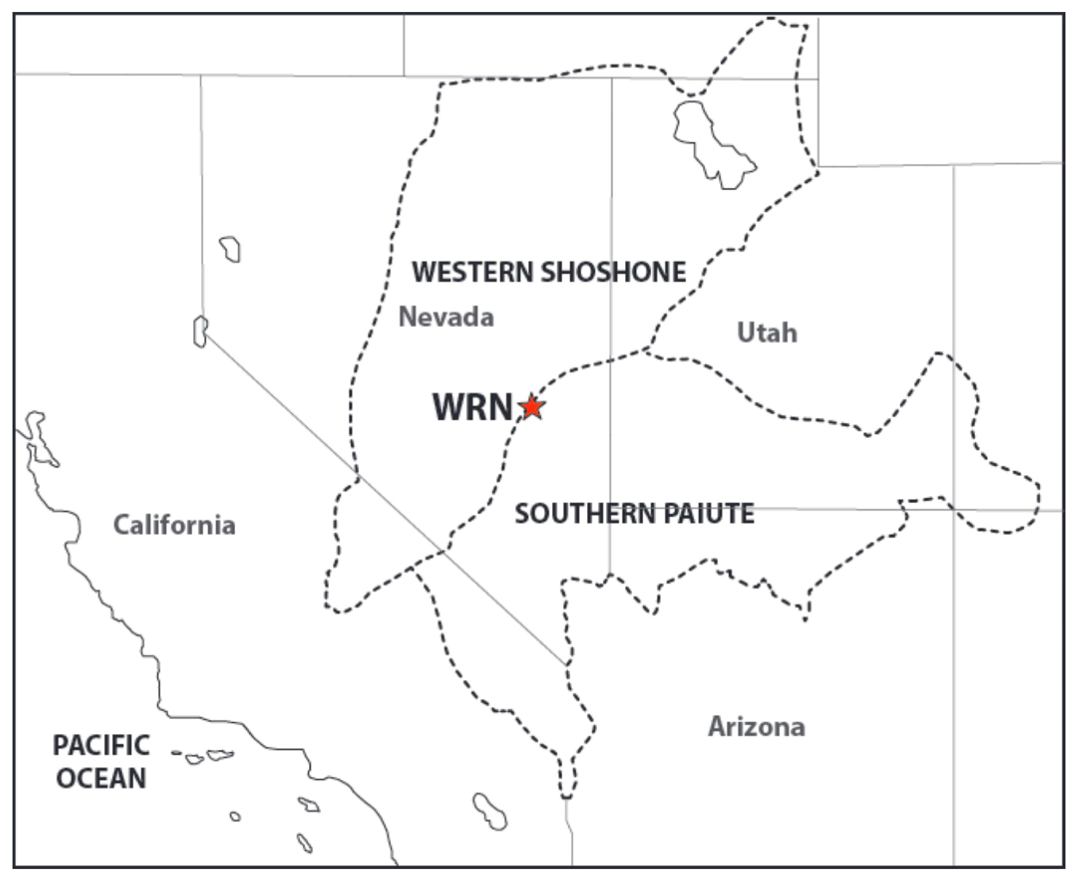
This article explores the acoustics of rock writing Site1 26LN211, the northernmost known petroglyph site within the White River Narrows (WRN) Archaeological District. At a global level, archaeoacoustic studies of rock writing sites have been undertaken for many years (for a global overview in Díaz-Andreu and Mattioli 2019; and for North America, see Primeau 2022). As can be seen in Figure 1, the WRN fall on land traditionally occupied by southern Paiute and western Shoshone, both closely related Numic-speaking groups. The site is located just beyond the White River Narrows canyon in Lincoln County, Nevada, USA. The river originates near the town of Ruth to the north and, after passing through the narrows, flows south through the Pahranagat Valley before joining the Muddy River, which soon merges with the Virgin, a tributary of the Colorado River. Highway SR318 runs through this narrow canyon, connecting the villages of Hiko and Lund. At an elevation of 4600 feet (1400 m) above sea level, the area has sparse vegetation, including shadscale, tall sage, ephedra, and invasive species such as cheatgrass and Russian thistle (Loubser 2020, p. 4).
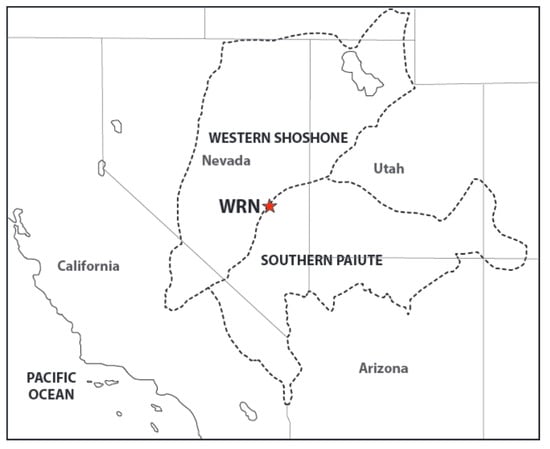
Figure 1.
Map showing the location of the White River Narrows. Source: Stratum Unlimited LLC, NY.
The WRN were included in the zone designated as the Basin and Range National Monument in 2015 due to “its geological, ecological, cultural, historical, paleoecological, seismological, archaeological, and paleoclimatological significance” (U.S. Department of the Interior 2015). The protection of the area is needed mainly due to numerous petroglyph sites within the WRN. Since the 1910s—and as recently as 2020 (Loubser 2020, Table 54)—their high visibility and easy accessibility have made them vulnerable to vandalism, leading to their gradual deterioration over the decades. The land is owned by the Bureau of Land Management (BLM) and managed by the BLM Caliente Field Office, which requested graffiti removal. In 2019 and 2021, Stratum Unlimited, led by Dr. Johannes Loubser, was contracted to camouflage the graffiti as a means to prevent further vandalism. Loubser also proposed creating a thorough graphic recording, overlap sequence, and inventory of the rock imagery of the area, which has been completed at five sites, including this one. The purpose of the full recording is to support the interpretation, future research, and public presentation. As part of the latter, he advocated for an acoustic study to enhance the site’s presentation as a multi-sensory experience for both archaeologists and visitors.
Loubser’s work in the area has been preceded by the location of rock writing sites and rock imagery recording by archaeologists W. White and A. Quinlan (see Whitley 2015)2. White first “found lithic debitage buried in the colluvial deposits at Loci II and III within the White River Narrows” (White 1998 in Loubser 2020, p. 4). The inspection of the level surface deposits below the lower petroglyph panels at Site 26LN211 revealed brown ware ceramic sherds and chert debitage. Loubser argues that the absence of surface artifacts within the canyon suggests that precontact remains may be deeply buried under the colluvium or washed away, but that habitation in the area was likely limited in any case (Loubser 2020, p. 4).
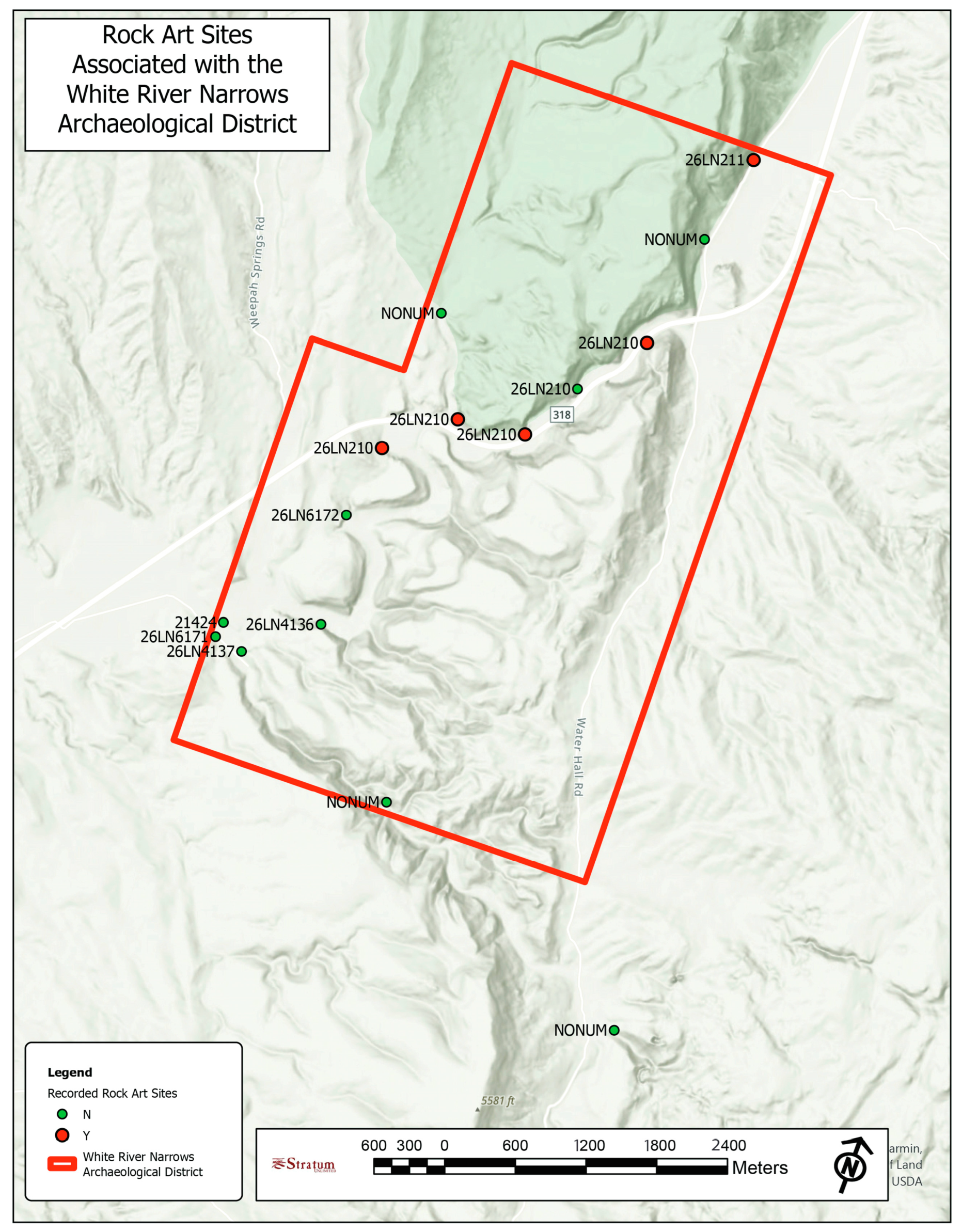
Twelve rock writing sites are currently known within the WRN (Figure 2). These sites feature rock imagery in the form of pecked and incised petroglyphs, as well as some red pictographs, created on stretches of vertical tuff cliffs (Loubser 2020, p. 4). Native Americans say that the rock imagery was primarily produced by the southern Paiutes and western Shoshone, the oldest dating to at least 7000 years ago, with a few additions made by neighboring Native American groups traveling through the WRN, between 1700 and 200 years ago (Loubser 2024, pp. 128, 136).
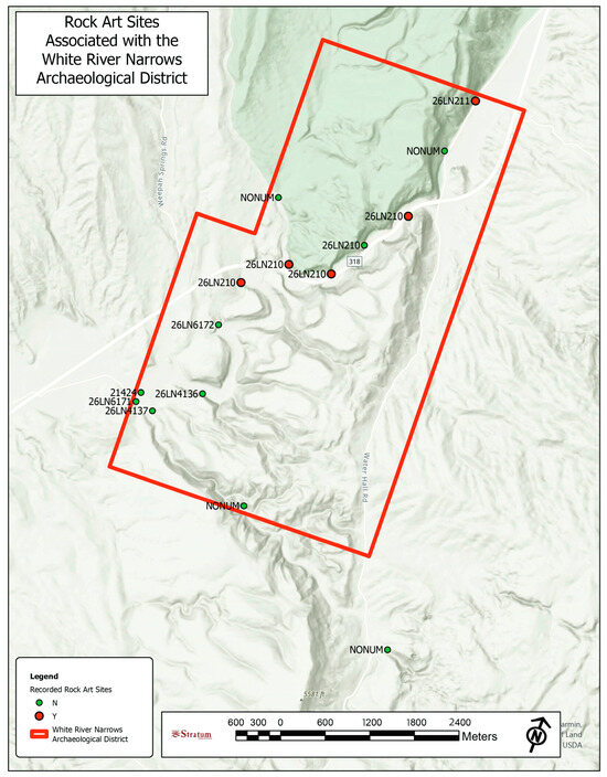
Figure 2.
Map of rock writing sites in White River Narrows. Source: Stratum Unlimited LLC, NY.
2. Previous Archaeoacoustic Research in Paiute Rock Writing Sites
In connection with Loubser’s proposal to conduct a comprehensive study of the rock writing area and develop materials for its future public presentation, an archaeoacoustic study of the WRN’s sites was planned. However, initial discussions between the authors Díaz-Andreu and Loubser were halted by the outbreak of the COVID-19 pandemic in 2020. Due to full restrictions on international travel, Stratum contracted Steve Waller to conduct the archaeoacoustics analysis of Sites 26LN210 and others in the narrows itself. Waller’s research aimed to determine whether the rock writing sites were selected for their acoustic properties. Near-field tests revealed that rock writing sites exhibited stronger echoes than unmodified locations, even when the rock surfaces had similar characteristics suitable for engraving.
The strongest reflections were recorded at Site 26LN210 Locus III. However, since some unmodified control locations also exhibited strong echoes, strong sound reflections cannot be considered a unique or sufficient criterion for site selection. Regarding far-field experiments, which explored long-distance sound transmission between rock writing sites, this study found that sounds produced at some sites were clearly audible from others, sometimes over 0.7 km away. This suggests that site selection may have been influenced by large-scale acoustic interactions rather than just localized echo effects (Waller 2020, 2023).
In the published literature, the case of the WRN canyon is not unique, as there is at least one other similar landform with echoes and significant reverberation where the Southern Paiute (Carroll 2007, Table 1-5) created rock imagery. We are referring to the War Shield canyon, a side gorge on the western flank of the Arrow Canyon, about 93 miles (150 km) south of the WRN. Several distinctive petroglyphs and pictographs have been found at the entrance of the War Shield Canyon, displayed on multiple rocks fallen from the cliff face. One of these boulder slabs, known as the Calendar Rock, features a War Shield motif (Carroll 2007, Figures 5-42, 5-43), a symbol related to the Ghost Dance ceremony, dated to the end of the 19th century (see below). The War Shield motifs appear again in the central area of the canyon, where the most pronounced reverberating conditions have been documented (Carroll 2007, pp. 300–1). The 19th century is only the date of that particular motif, for in interviews held as part of Kristen J. Carroll’s doctoral thesis, she was told that many petroglyphs were older (Carroll 2007, p. 309). Carroll’s interest in sound led her to ask about it in her interviews. Several Southern Paiute mentioned that it contributed to a place’s sacredness, while another one said that it was important for the selection of a location as a place of worship because there was “a reason you hear things. Sometimes a place will tell you things” (LM in Carroll 2007, p. 308).
What else is known about the Paiutes in relation to sound? Three different types of evidence will be indicated here: legends, oral tradition, and dances. Waller cites Gill and Sullivan’s mention of a Paiute’s legend that “describes witches (tso-a-vwits) living in the belly of mountain sheep and in snakeskins hidden among rocks, from which they take great delight in repeating in mockery the words of passersby (Gill and Sullivan 1992, p. 79)” (Waller 2000, pp. 89–90). The relation between witches and echoes is also found among the Shoshone (Lowie 1924, pp. 195–96), Ute, and Paiute (Powell 1881 in Waller 2005, pp. 47–48). Southern Paiute used song recitatives to transmit information in “epigrammatic forms, proverbs, ritualism, poetry and verse, and storytelling” (Carroll 2007, p. 93).
Dances always imply music, and according to the information gathered by anthropologist Isabel Kelly, the traditional ceremonial gatherings of the Southern Paiute included the “Cry” and the “Round Dance” (Kelly and Fowler 1986, pp. 383–84). These were complemented in the early 1900s by the “Bear Dance” (Carroll 2007, p. 290). Carroll also mentions the information recorded by James Mooney about a Paiute from Southern Utah who moved to Fort Whipple in Arizona to show the Ghost dance to the Hualapai (Carroll 2007, p. 291). “Each dance lasted five nights, and on the last night was kept up until daylight. Just before daylight on the morning of the last night the medicine men ascended a small butte, where they met and talked with the expected god, and on coming down again delivered his message to the people” (Mooney 1896, pp. 814–15). By 1926, traditional dances had nearly disappeared (Carroll 2007, p. 292).
Some publications also link rock imagery with sound. In 1940, Frank Beckwith (1875–1951), a bank cashier turned explorer, rock writing specialist, and anthropologist, interviewed Joe Pickyavit of the Pahvant Utes (Paiutes), asking him about the motifs in the petroglyphs Millard County area in Utah (Hales 2013). Pickyavit described the dances and songs associated with the rock writing motifs that included information about his people’s long migration from the northwest, and some events and some dances that happened along the way (Patterson Rudolph 2000, p. 115). Moreover, ethnographic interviews conducted by anthropologist Richard Stoffle and his team enabled them to identify the site with the name of Kanab Creek Canyon, an isolated location where the side canyon of Kanab Creek starts to shape the outer boundary of the Grand Canyon, as the place of a single event—a Ghost Dance ceremony performed by Southern Paiute and perhaps Hualapai people in the late 1800s (Stoffle et al. 2000). The date of the petroglyph is marked by the events taking place at that time in the area, in what has been called the Ghost Dance movement, first of 1870 and then going through a revival in 1889–90. This movement involved many groups, and attempted to stop the disruption at all levels taking place because of the arrival of Euro–American settlers and the colonization of their traditional territories. If performed well, the invaders were expected not to survive the dance (Stoffle et al. 2000, pp. 12–13)
It is important to consider that in contemporary Southern Paiute oral tradition, rocks are believed to be alive and powerful and that, therefore, marking is not carried out casually. Culturally appropriate behavior has to be followed, including certain obligations towards the rock. The Paiute consultants interviewed by Richard Stoffle and his team claim that the markings were probably created by individuals with religious knowledge (Stoffle et al. 2000; see also Carroll 2007, p. 309).
3. A Short Review of Recording at Site 26LN211
The following information is a summary of recordings completed by Stratum Unlimited at Site 26LN211, also known as the Northern Site. Recording included mapping and three-dimensional photography with a drone, close-up photographs in different light conditions at different times of the year and day, night-time photography with LED lights, digital tracing from digitally enhanced photos, the double checking of digital tracings, and the detailed documentation of motif overlaps (Loubser 2024).
Site 26LN211 is located along a rhyolite tuff cliff. It is accessible via a dirt road that branches off the main SR318 highway just after exiting the canyon on its north side. This small road, an older route replaced by the modern highway running almost parallel about 600 m (0.4 miles) away, runs near the site, coming within seven to ten meters of the cliff. The site consists of three levels: a ground level, a second platform above it, and a third cliff rising from the second level. Petroglyphs are found on the wedged-pattern rock face at ground level (see Figure 3). On the second level, two small, low stone walls form U-shaped enclosures against the cliff’s rear wall. These structures have been identified as likely vision quest blinds.
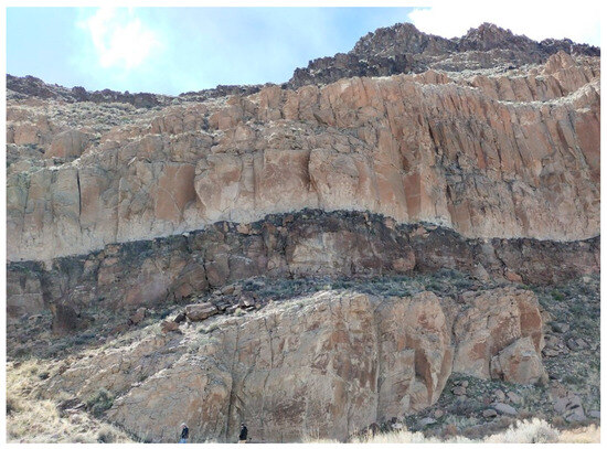
Figure 3.
Site 26LN211. ©Artsoundscapes Project.
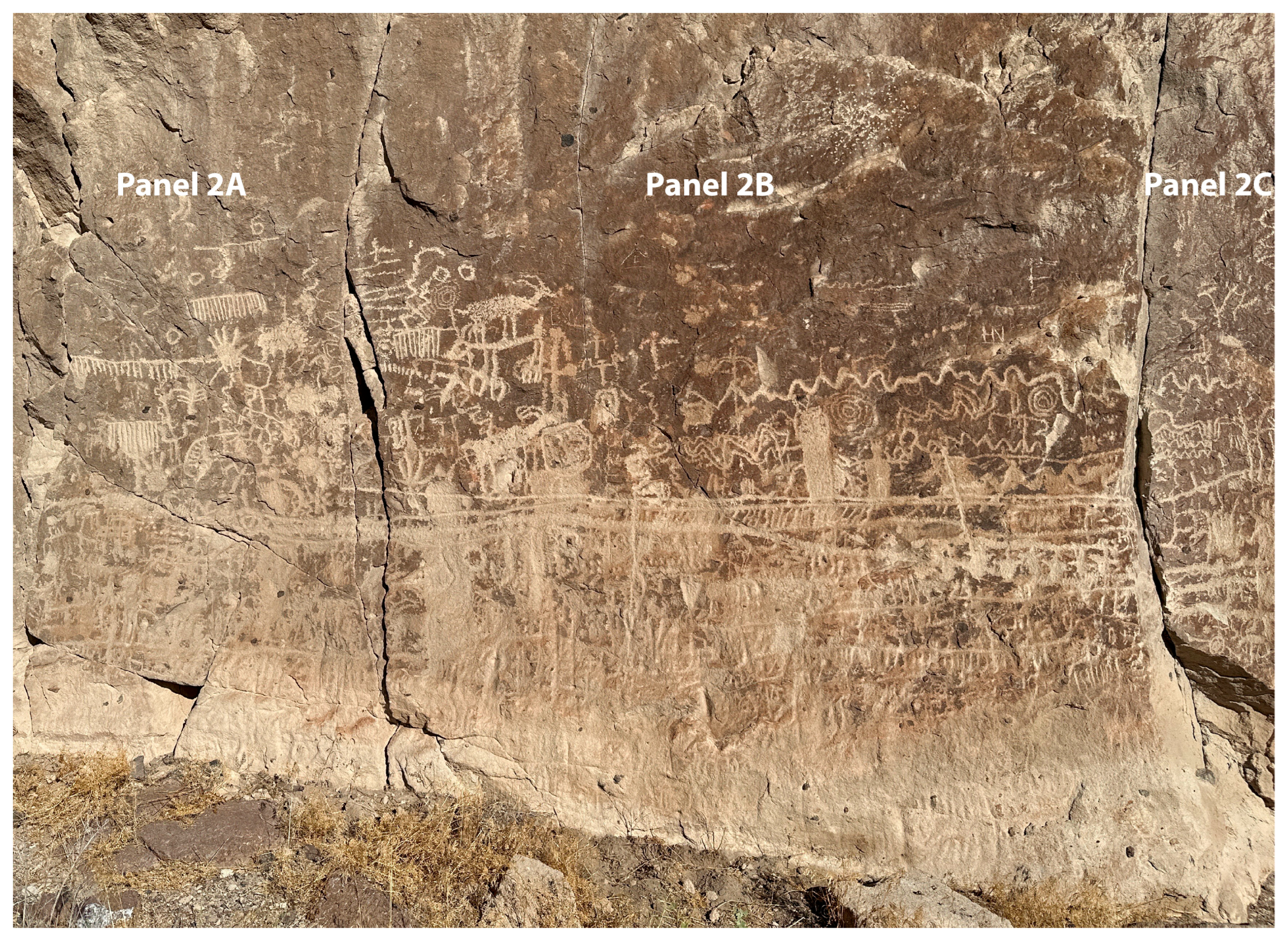
A total of 39 different panels containing 1314 motifs have been recorded at Site 26LN211 (Figure 3, Figure 4 and Figure 5). Of 1314 motifs, footprints (n = 100, 7.6%) are the most common motifs at Site 26LN211, followed by bighorn sheep (n = 81, 6.2%), and ruminant hoof prints (n = 65, 4.9%), while 32 motif categories are represented in a single occurrence only, which includes figures with unique head appendages and idiosyncratic zigzags. Footprints are the most ubiquitous motif at Site 26LN211, occurring in 23 panels (59% of all 39 panels), followed by bighorn sheep (n = 19, 48.7%), and horizontal lines comprised of short vertical dashes (n = 18, 46.2%). Thirty-eight motif categories (26.8% of 142 motif categories) are limited to a single panel. The close-up and repeated observation and recording of direct overlaps between motifs revealed trends in the production of rock images at the site (Figure 6). When direct overlaps between pairs of motifs are compared, thinly incised lines and lines comprising of tiny dots or thin vertical dashes are consistently at the top of the sequence, with no exceptions. A few isolated light-colored arcs and isolated short straight lines that were added to earlier darker and weathered motifs, such as on top of bighorn antlers and legs or the arms of a human-looking figure, suggest highlighting specific portions of pre-existing motifs. Ocher smears on top of pecked motifs in two panels are later additions too.
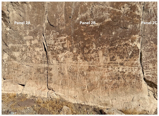
Figure 4.
Site 26LN211. Panel 2B. Source: Stratum Unlimited LLC, NY.

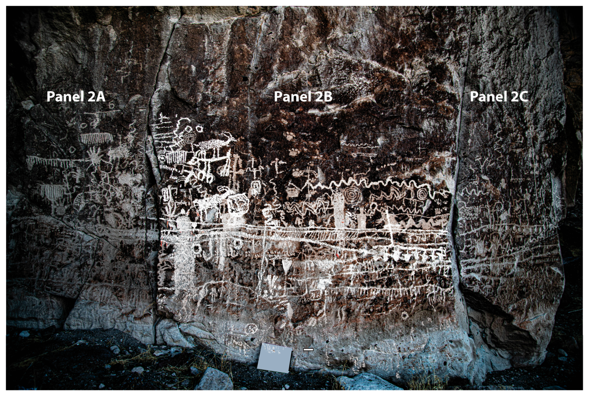
Figure 5.
Frontal view of the overlapping motifs in panel 2B. Source: Stratum Unlimited LLC, NY.
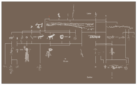
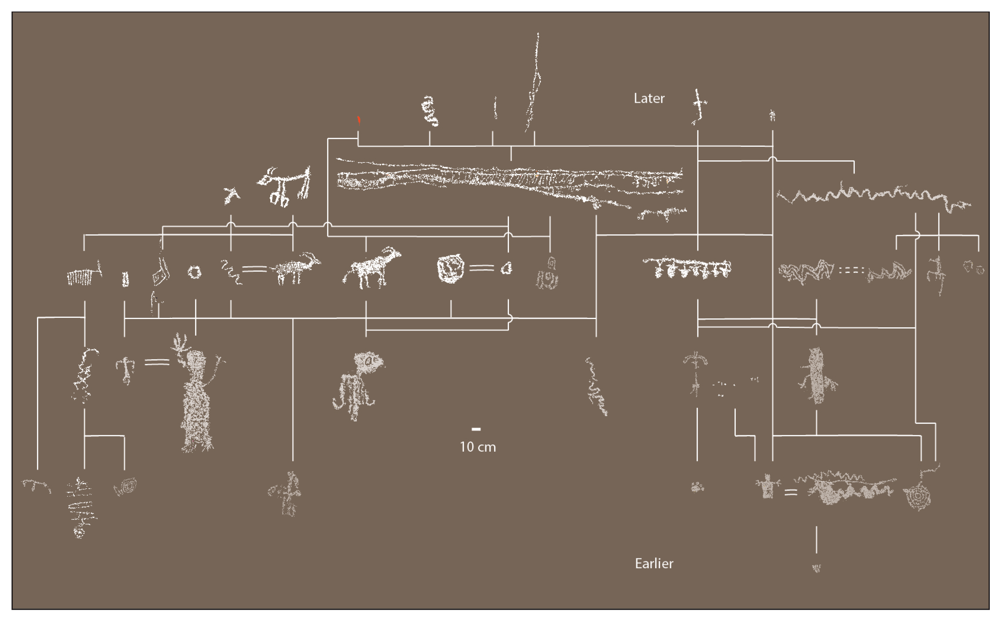
Figure 6.
Site 26LN211. Panel 2B. Harris matrix. Red indicates red ocher pigment smears. Source: Stratum Unlimited LLC, NY.
The thin lined incisions resemble the thin-lined painted red lines at Locus II of Site 26LN211 in the nearby WRN (Loubser 2020, p. 126). Long horizontal lines that connect multiple panels tend to be among the latest in the overlap sequences. Together with relatively late long vertical lines, the long horizontal lines appear to connect at certain earlier but spatially separate motifs. Ubiquitous bighorn sheep depictions are concentrated in the middle of the relative overlap sequence at Site 26LN211, being below other motif categories in 50 percent of overlaps. The care and detail of bighorn pecking seems to first improve from their initial depictions, but then deteriorate in the most recent applications.
Overall, bighorn sheep tend to become more popular later in the overlap sequence compared to the generally darker and more weathered mule deer depictions. The latter is below paired motifs in 60 percent of overlaps. Meanders, zigzags, and conjoined enclosed curvilinear shapes occur throughout the middle portion of the sequence, but appear to be absent in the earliest layers and scarce in the latest layers. Pawprints, hoofprints, and footprints are slightly lower down the sequence, all being below other motif categories, between 60 and 70 percent of paired overlaps. Spirals, almost all of which appear relatively dark and weathered, occur below paired motifs in 90 percent of the overlaps, suggesting that they pre-date most of the motifs at the site. Highly patinated and/or weathered grid-looking and concentric ring motifs tend to occur closer to the ground surface than the rest of the motifs within the same panel. These grid-looking and concentric ring motifs are consistently at the bottom of paired overlaps, with no exceptions. These can be ascribed with confidence as the earliest motifs at Panel 2B of Site 26LN211.
When assessing the significance of the 26LN211 Site, it is important to consider that rock writing locations—particularly those with a high concentration of motifs, such as this site—were associated with supernatural power (Whitley 2015, p. 9). The extended timeline for the creation of motifs suggests that this rock was repeatedly visited over many generations, century after century, reinforcing its perceived religious significance and sanctity. Given the significance of Site 26LN211 and the importance of songs and storytelling among the Southern Paiutes, it is most likely that these practices were practiced there.
Additionally, the position of Site 26LN211 at the northern end of the WRN most likely contributed to its special significance. The site’s unique role is not only emphasized by the large number of motifs and the long time people kept returning to it, as shown by superimpositions, but also by the presence of two small, low stone-walled enclosures on the upper ledge above the panels, which have been interpreted, following Friesen (2013), as vision quest structures (Loubser 2024, p. 138). These are not unique to this location; similar structures have been identified above Locus III of Site 26LN210 in the canyon, as well as at the petroglyph site east of the Ambush Canyon parking lot (Loubser 2024, p. 138). Analogous structures, though larger in size, are also found at Black Butte, which lies within the same drainage system as our study area, approximately 46 km (28.6 miles) to the south of WRN. These structures are situated above the petroglyphs in the Black Canyon. The Southern Paiutes have identified these sites as places where Puhagants (Medicine People) go to pray and seek visions (Stoffle et al. 2022, p. 16).
4. Acoustic Study of Site 26LN211
The primary goal of the acoustic analysis at Site 26LN211 was to search for evidence of the influence of acoustics on the production and placement of rock imagery. To achieve this main objective, we first explored the relationship between the positioning of rock imagery and the presence of particular acoustic effects such as echoes or highly directive intense sound reflections. Secondly, we focused on examining whether the site supports the hypothesis of a connection between rock imagery and locations with exceptional acoustics in the WRN area. Finally, we investigated the acoustic interaction between the two vision quest blinds situated on a terrace above Site 26LN211 and the petroglyph site below (see Figure 3).
4.1. Methods (I) Fieldwork Phase
The fieldwork was conducted from 8 April to 12 April 2024. Given the topography of the site, an impulsive sound source was utilized to record a representative set of impulse responses (IRs).3 Impulses were generated using controlled balloon bursts, with careful attention to the inflation diameter (119 cm) and the prick-off point, following the methods outlined by Pätynen, Katz, and Lokki (Pätynen et al. 2011). To enhance the reproducibility, each source-receiver pair was tested with a minimum of three repetitions. The IRs were captured using two microphones, a micW n201 omnidirectional microphone and a Sennheiser Ambeo VR, a first-order Ambisonics microphone array, both connected to a Zoom F4 multitrack field recorder, which was used as the sound device. The omnidirectional microphone enabled the recording of calibrated impulse responses in compliance with ISO standards (International Organization for Standardization 2009), allowing for the calculation of monaural acoustic parameters. The Ambisonics microphone captured spatial impulse responses, making it possible to subsequently analyze the Direction of Arrival (DOA) of the most significant reflections.
The positioning of the emitter and receiver points was carefully determined based on five different hypotheses of spatial configurations that were linked to the objectives:
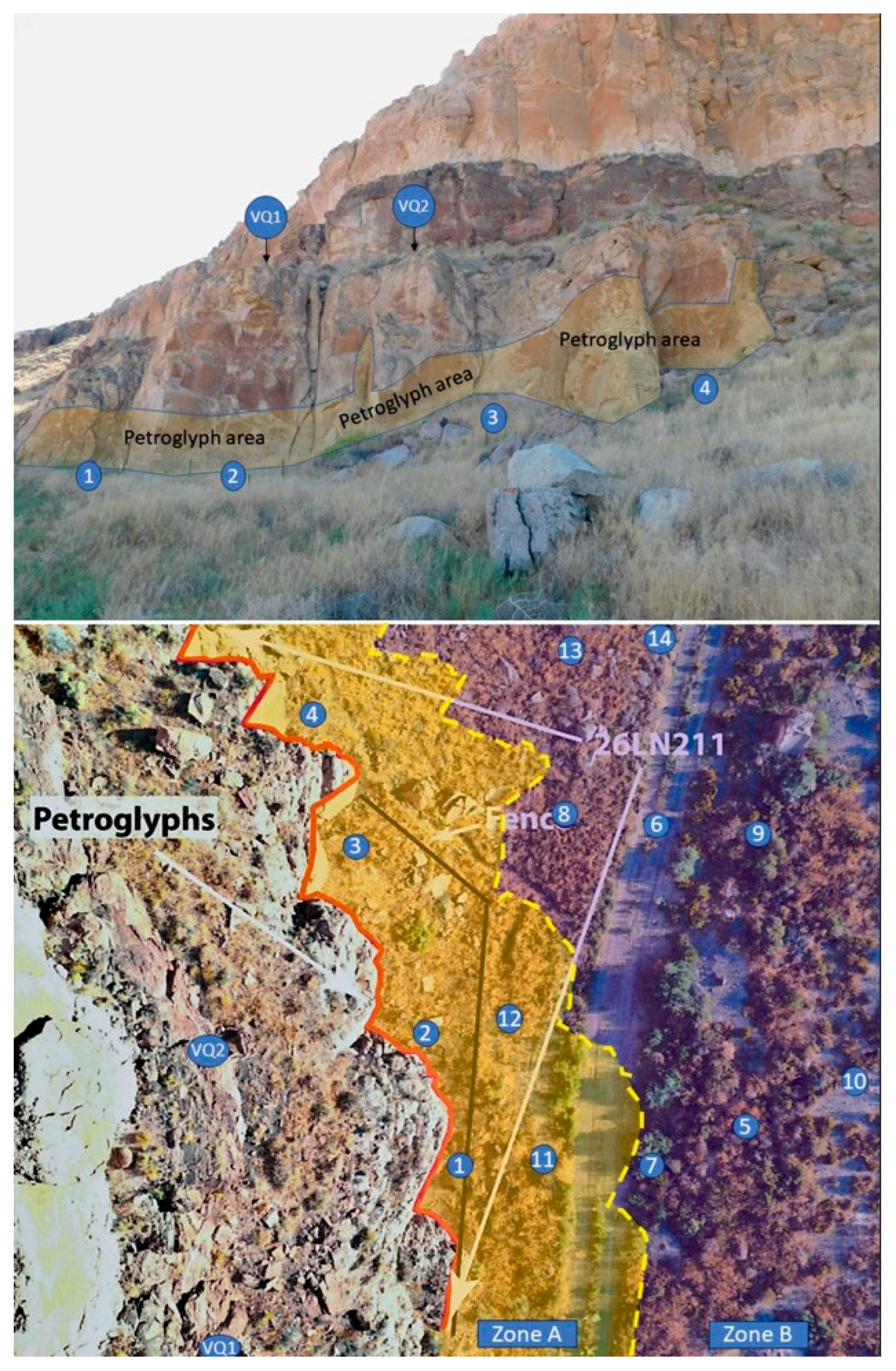
- Hypothesis 1 or “distance measurements”: In this configuration, both the sound source and the receiver are in an area at least 15 m away from the cliff with the petroglyphs (Zone B, see Figure 7). In each combination, the microphone is placed approximately five meters from the sound source to represent a near audience and explore the possibility of hearing the echoes of one’s own sounds. This minimum distance of five meters is imposed by technical reasons to avoid saturation when recording the powerful impulse generated by the balloon explosion.
 Figure 7. General views of the site. The approximate location considered for the sound source and the microphones are labeled in blue. The surfaces with petroglyphs are highlighted in the frontal view of the cliff (top image). The considered zones for the different spatial configuration hypotheses are delineated in the plan view image (lower image). Numbers represent the locations chosen both for emitters and receivers. The original plan view photo courtesy of Dr. Johannes Loubser and Joel Logan. ©Artsoundscapes Project.
 - Hypothesis 2 or “distance audience”: in this case, the emitter is close to the petroglyph panels (Zone A, see Figure 7), and the receivers are located relatively far, representing a numerous group of listeners that could have been positioned in this more distant area for various reasons.
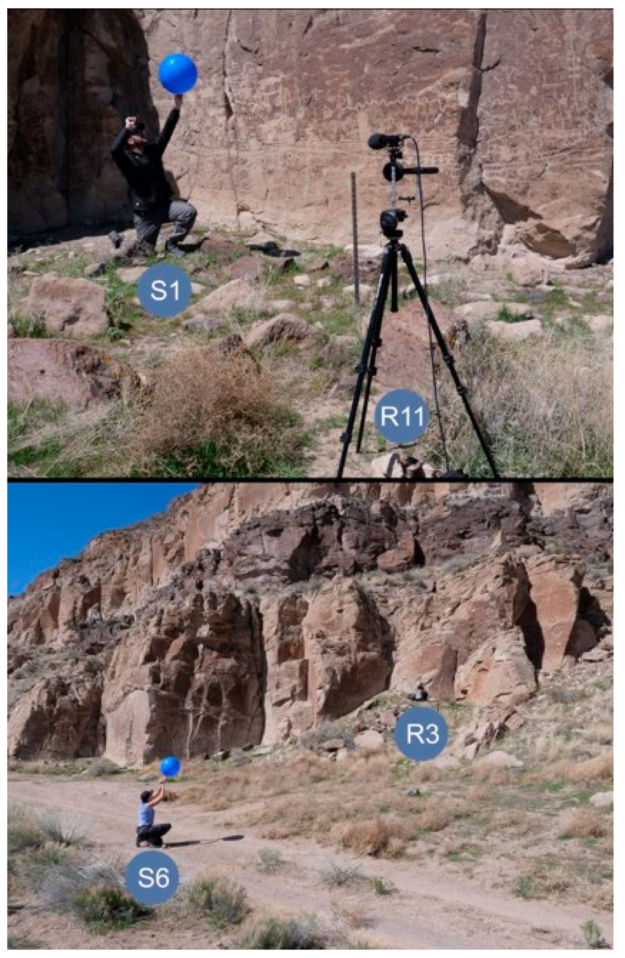
- Hypothesis 3 or “near measurements”: this scenario represents a situation where both the emitter and the listeners are in an area relatively close to the petroglyphs (Zone A), creating a more intimate setting (Figure 8).
 Figure 8. Picture taken during fieldwork at Site 26LN211, showing the spatial arrangement at position S1-R11 (Hypothesis 3 or “near measurements”) and at position S6-R3 (Hypothesis 4 or “distance source”). ©Artsoundscapes Project.
 - Hypothesis 4 or “distance source”: This configuration accounts for a situation where the emitter is placed far from the panels (Zone B), while listeners are positioned next to it (Zone A). This configuration will provide the emitter with a broad view of the cliff (Figure 8).
- A fifth hypothesis was used to study the interaction between the site and the two likely vision quest blinds found at the rear of a terrace immediately above Panels 1 and 2. In this case, it is considered that the listener is positioned within one of the likely vision quest blinds, and the sound source both in front of the main panel of petroglyphs under each likely vision quest blind (meaning no visibility between source and receiver), as well as in a more distant position in front of them (where there is visibility between the source and receiver).
In all cases, both the balloons and microphones were placed at a height of approximately 1.45 m from the ground, representing the mouth and ear level of an average standing person. The approximate locations of the emitter and receiver points can be seen in Figure 6, while Table 1 provides a summary of the source and receiver combinations included in the survey. The midsection of the panels served as a reference for setting the source/receiver locations and measuring their distance from the petroglyph panels.

Table 1.
Summary of the source and receiver combinations (S-R pairs) included in the survey of Site 26LN211. The IRs recorded with the omnidirectional microphone (W IRs) and the ambisonic microphone (Ambisonics IRs) are included in separate rows.
The environmental conditions4 were observed during the entire fieldwork campaign. A UNI-T UT363BT anemometer was used to monitor the weather conditions. The temperature varied between approximately 17.2 °C and 22.4 °C, with low humidity levels. Average wind speeds ranged from 0.4 to 2.8 m per second, with occasional gusts reaching up to 5.1 m per second, which at times slightly delayed the data collection. Background noise measurements were taken at various times each day using a Cesva SC 202 sonometer placed at R08, VQ1, and VQ2. The recorded equivalent continuous sound pressure level (Leq) ranged between 42.48 and 43.67 dBA. Non-natural background noise primarily consisted of intermittent vehicular sounds from irregularly spaced traffic along SR-318.
4.2. Methods (II) Post-Processing Phase
The commercial software tools EASERA (www.afmg.eu), MATLAB R2022a (MATLAB 2022), and REW (n.d.) were used for digital post-processing and analyzing the omnidirectional IRs, including the calculation of monaural acoustic parameters. Spatial IRs were analyzed with MATLAB R2022a and IRSpatial.5
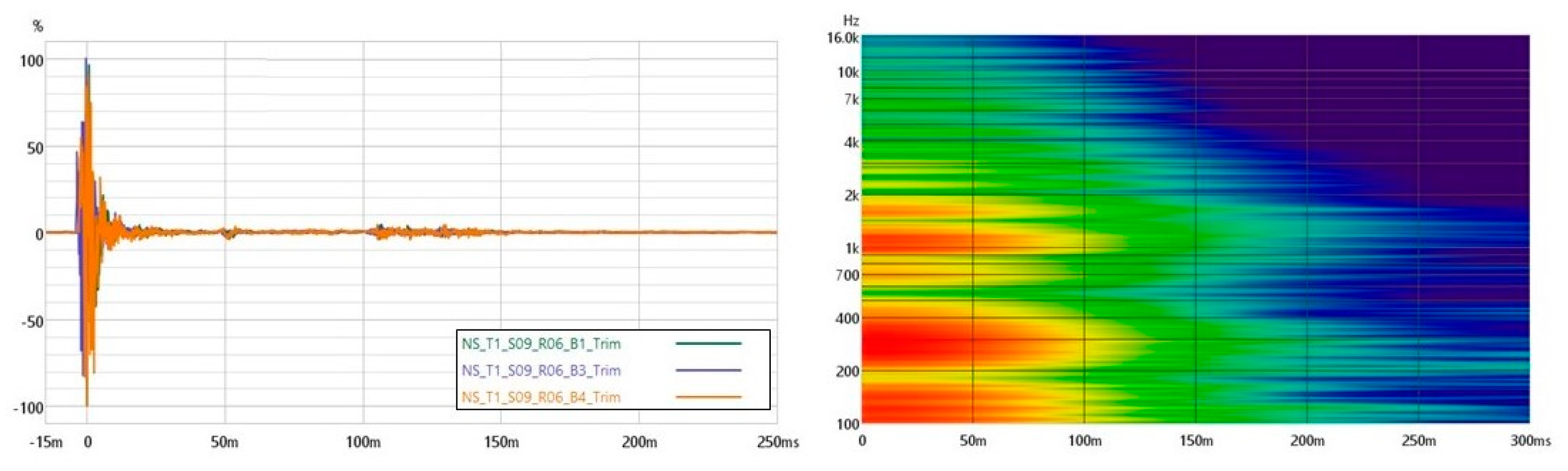
Given the open nature of the studied site, the environmental conditions, and previously published studies (Paini et al. 2011; Rindel 2023) three acoustic parameters listed in the ISO 3382-1 were selected for the acoustic characterization of the site, considering the different spatial configurations (Hypotheses 1 to 4). Sound clarity is assessed by means of the speech definition (D (-)) and the center time (TS (ms)). Given the constraints inherent to the empirical method, an approximation6 of the strength parameter (G* (dB)) is used to evaluate the capacity of the site to increase the loudness of sounds depending on the S-R positions (Katz 2015). The discussion of these parameter values focuses on the octave band of 1 kHz, considering them as representative in this case, provided that no unusual behavior is observed within another frequency band, and in view of the emission spectrum (see Figure 9) and directivity of the balloon pops (Pätynen et al. 2011).

Figure 9.
Example of normalized impulse responses recorded for the 3 balloon pops in the S09-R06 combination at Site 26LN211. On the right, the spectrogram of one of them is also plotted, showing frequency content over time. The color intensity represents sound amplitude (dB), with warmer colors indicating higher energy levels. ©Artsoundscapes Project.
4.3. Results
The results derived from the acoustic measurements allow for modeling auditory perception at rock imagery sites according to different hypotheses of use and listener positions.
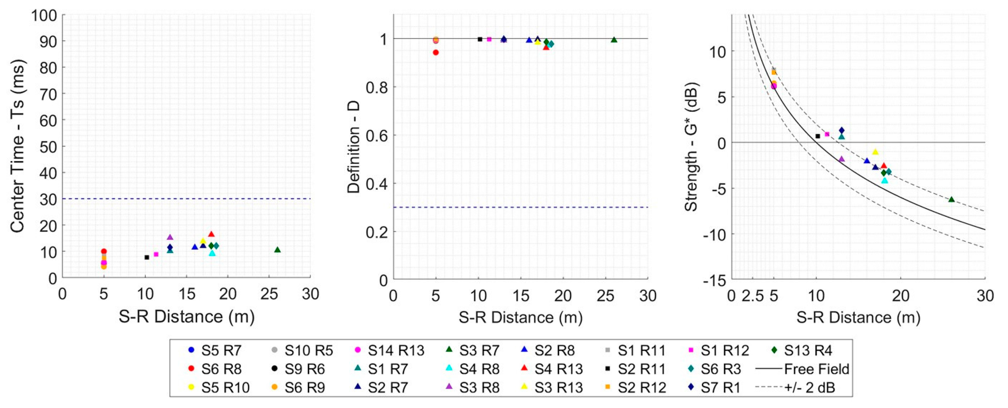
In general, the results correspond to the expected acoustics in open fields regardless of the spatial configuration considered. The monaural acoustic parameters reflect the expected high clarity of sound perceived by listeners in Zones A and B, with D values approaching unity and TS values well below 30 ms (Figure 10). This is due to the low reflection density and lack of a reverberation tail in the IRs, as evidenced in the examples provided in Figure 9. There is no evidence of loudness amplification caused by the site either, since the G* values are, in most of the cases, only a maximum of 2 dB above of what is expected in a free field (see Figure 9).
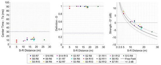
Figure 10.
Selected acoustic parameter values obtained from omnidirectional impulse responses (IRs) recorded at Site 26LN211, analyzed at 1 kHz. All the source–receiver combinations used to study Hypotheses 1 to 4 have been included. © Artsoundscapes Project.
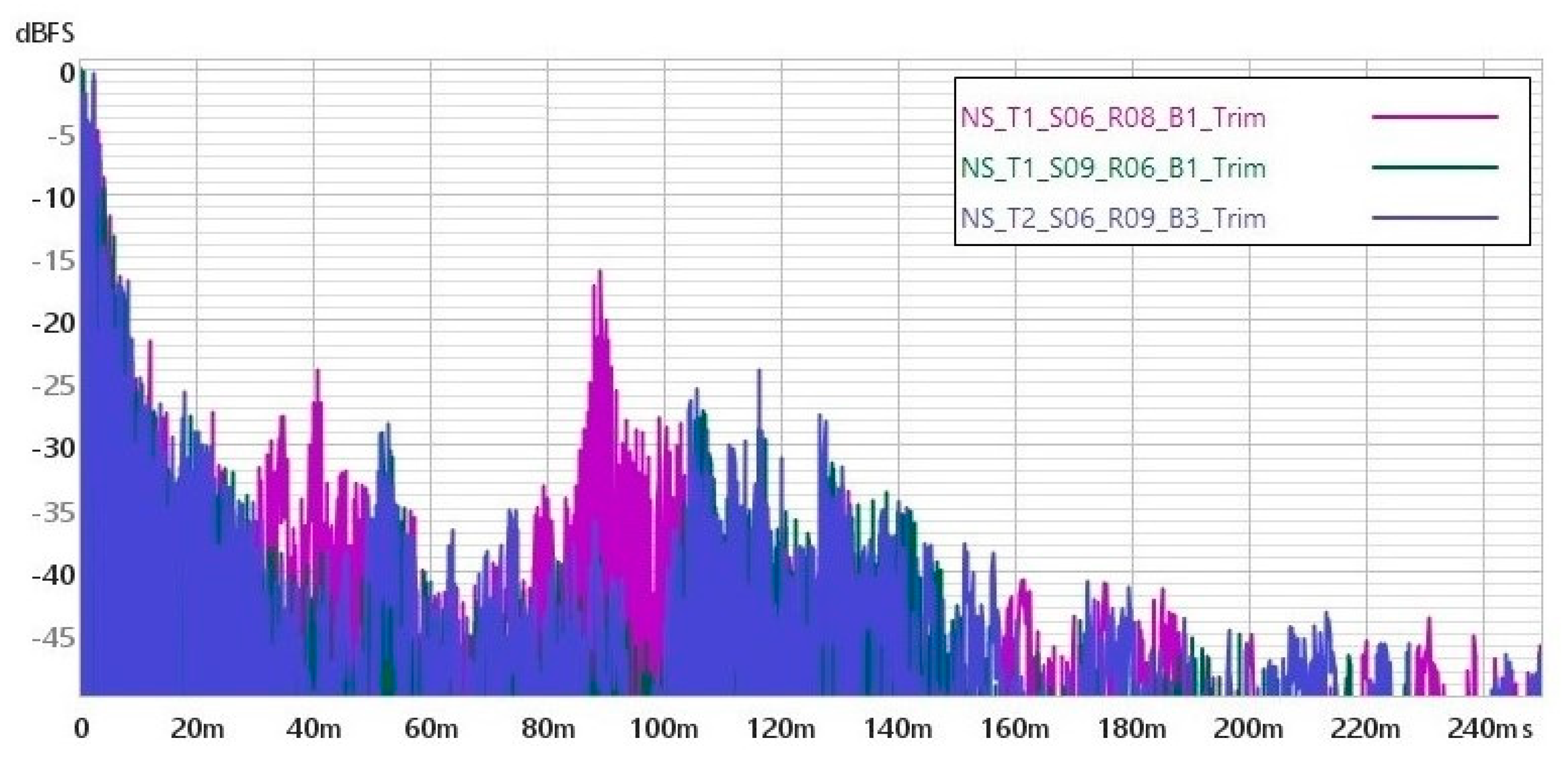
The IRs were also examined to explore the presence of audible echoes.7 We found that audible echoes are produced when analyzing Hypothesis 1, in which both the sound emitter and the listeners were positioned in Zone B. These reflections were most pronounced when both the source and receiver were placed in front of Panels 5 and 6 of the petroglyph surface (Løvstad 2003). Figure 11 shows the impulses registered at the combinations where the echo is audible. By studying the Direction of Arrival (DOA) of those reflections, there is an early set of reflection (arriving around 45 ms after the direct sound) coming from the skirt of the cliff, and a late set of reflections (those causing the echo) arriving around 120 ms after the direct sound.
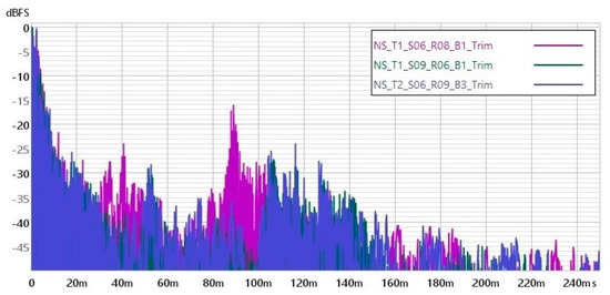
Figure 11.
Omnidirectional impulse responses captured at three combinations of Hypothesis 1 at Site 26LN211, in which the presence of high-amplitude late reflections results in an audible echo. ©Artsoundscapes Project.
Hence, the acoustic results from the four tested configurations suggest the following. In the “distance measurements” configuration (Hypothesis 1), sound was clearly perceived, although strong late reflections from the cliff skirt produced audible echoes, particularly near Panels 5 and 6. In contrast, the “distance audience” setup (Hypothesis 2) showed no evidence of late reflections or reverberation that might compromise speech clarity, nor did it enhance sound loudness despite the source’s proximity to the cliff. The “near measurements” scenario (Hypothesis 3) demonstrated favorable conditions for sound transmission due to the short distances involved and minimal background noise interference. Similarly, in the “distance source” configuration (Hypothesis 4), the absence of late reflections and the presence of early reflections near the listener contributed to the clarity of sound perception.
Regarding the fifth hypothesis, the results do not show a significant acoustic relationship between the petroglyph zone and the likely vision quest blinds. When the listener is in the VQB and the source is placed below, whether in Zone A or B, the sound level reaching the listener is highly attenuated. This is especially true when the sound source is near the petroglyphs (Zone A), as there is no direct sound propagation path and the received level is even masked by wind noise.
5. Discussion and Conclusions
This article on the archaeoacoustics of rock imagery at Site 26LN211 in the White River Narrows (WRN) Archaeological District, Nevada, sheds new light on the acoustic characteristics of this culturally significant site. However, it also presents several limitations. The first one relates to the reason why the place was chosen to create petroglyphs in the first place. We acknowledge that there may be other reasons that explain this related to other qualities of the place (see Whitley et al. 2025). From an acoustic point of view, the most significant limitation is that the acoustic analysis primarily relies on impulse response recordings, which may not fully capture the complex auditory experiences of Indigenous groups. Additionally, this study’s scope is limited to a single site, which restricts the generalizability of its findings to other petroglyph sites within the WRN. This becomes particularly evident when the results of the archaeoacoustic study of Site 26LN211 are contrasted with those of Steve Waller’s acoustic analysis of the sites located within the narrows of the White River itself (Waller 2020, 2023). While Waller identified a strong presence of echoes, reverberation, and interaction between sites, the acoustics of Site 26LN211 reveal a lack of reverberation, allowing for a clear transmission of sound, with the only presence of audible echoes in the areas farthest from the surface where the petroglyphs are located (Hypothesis 1 or “distance measurements”). Yet, the significance of the place, evidenced by the continuous addition of motifs over centuries in Site 26LN211, is undeniable. How should this be interpreted? If, as the southern Paiutes believed, rocks are alive (Stoffle et al. 2000), would they not have different personalities depending on their location? A site within a canyon could demonstrate its power by reflecting sound waves, creating either sound persistence (reverberation) or repeated sounds (echoes). A site in an open area would have held a different kind of power and been used in other ways. Since reverberation and echoes are not ideal for places where oral transmission occurs, sites like 26LN211 would have been well-suited for this purpose. When stories, legends, and myths are conveyed—whether through song recitatives, as mentioned above, or in other forms—clear sound is essential for effectively communicating the message being shared.
In addition to being an ideal location for the transmission of oral traditions, the flat area in front of Site 26LN211 was also well-suited for conducting dances. There is no evidence in the literature suggesting a particular preference for sites with echoes and reverberation for such an activity. On the contrary, in the War Shield Canyon, the most likely dancing area was the Table Mountain, a sandstone mesa on the northwest side of the Arrow Canyon, where a dance circle was located. However, in Site 26LN211, the visual observation has not identified a similar feature, although the abandonment of dances a century ago and the accessibility of the site may have led to high disturbance. In any case, the possibility that the adjacent area served as a dancing ground remains speculative. Finally, the lack of significant acoustic relationship between the petroglyph zone and the likely vision quest blinds is perhaps to be expected: vision quests and contacts with personal spirit helpers are highly personal affairs, private, and intended to be out of sight and perhaps beyond hearing range. Actually, some remnants of vision quest blinds found by Stratum Unlimited on ridge lines directly above two other petroglyph sites within the WRN are on open ground, without any cliffs at the back, making it highly unlikely that individuals below creating the petroglyphs or looking at the petroglyphs could hear sounds being emitted by ritual practitioners from up there, or vice-versa. An example is the above-mentioned case of the Ghost dancing ceremonies taken by a Paiute to Arizona, which were finalized by the medicine men leaving the dance area and going to a higher place nearby where they received some illumination by “the expected god”, later transmitting this to the rest of the group. However, the quester’s perception of sound inside the vision quest blind should also be considered. In vision quests, visions might come accompanied with sounds or a song that play a significant role in the seeker’s life, especially if it carries strong medicine. In this sense, the confined space formed by the two low stone-walled structures might have created a distinctive spatial impression characterized by intense early reflections that heightened the quester’s perception of sound inside the vision quest blind, especially if they adopted an inclined posture or were lying on the ground. Furthermore, places where potent medicine revealed itself were often honored and returned to time and again (Zedeno 2000).
The results of this archaeoacoustic study are not unique. The experience gained through the Artsoundscapes project at numerous rock writing sites worldwide suggests a broad range of variations in how sound behaves in these locations. Just as sites within the same artistic tradition can differ significantly in their location, the typology of the motifs inscribed in them, and their quantity, similar disparities are also evident in their acoustic properties. Indeed, there is no universal formula for their sonic performance, and archaeoacousticians must remain open to embracing this sensory diversity.
6. Final Implications
The findings of this study offer important broader implications for both archaeoacoustic practice and heritage management. First, they underscore the necessity for archaeoacousticians to move beyond the search for universal acoustic patterns and instead embrace the sensory and sonic diversity of each site. As demonstrated by Site 26LN211, acoustic properties can vary dramatically, even within the same artistic or cultural tradition, suggesting that soundscapes were intentionally engaged with in different ways depending on the desired function—be it storytelling, ritual, or personal spiritual experience. The Southern Paiute belief that rocks are alive, potentially imbued with unique “personalities” based on their location, invites researchers to adopt more culturally situated and ontologically sensitive interpretive frameworks. Functionally, the identification of low-reverberation sites as potentially ideal for oral transmission further illustrates how acoustic environments may have been deliberately selected to suit specific communicative or ceremonial needs.
From a heritage management perspective, this research emphasizes the importance of considering acoustic integrity as an essential component of a site’s intangible heritage. Conservation efforts should account not only for the visual and material aspects of a site, but also for preserving its natural acoustic environment, particularly against the intrusion of modern noise pollution. Moreover, interpretive strategies can be enriched by incorporating the acoustic dimension into visitor experiences, such as through controlled soundscapes or educational programming that highlights indigenous auditory traditions. Crucially, the findings challenge the notion that only acoustically dramatic sites are culturally significant, reminding us that seemingly quiet or acoustically subdued locations may hold profound meaning within indigenous cosmologies. This reinforces the value of inclusive heritage practices that integrate indigenous knowledge systems and support collaborative stewardship models.
Author Contributions
Conceptualization, M.D.-A., L.A.-M., D.B.-A., D.M.I. and J.H.N.L.; methodology, M.D.-A., L.A.-M., D.B.-A. and D.M.I.; software, L.A.-M., D.B.-A., and D.M.I.; validation, L.A.-M., D.B.-A., and D.M.I.; formal analysis, M.D.-A., L.A.-M., D.B.-A., D.M.I. and J.H.N.L.; investigation, M.D.-A., L.A.-M., D.B.-A., D.M.I. and J.H.N.L.; resources, M.D.-A. and J.H.N.L.; data curation, M.D.-A., L.A.-M., D.B.-A., and D.M.I.; Visual data curation: M.D.-A., L.A.-M., D.B.-A., D.M.I. and J.H.N.L.; writing—original draft preparation, M.D.-A., L.A.-M. and J.H.N.L.; writing—review and editing, M.D.-A., L.A.-M. and J.H.N.L.; visualization, M.D.-A., L.A.-M., D.B.-A., D.M.I. and J.H.N.L.; supervision, M.D.-A., L.A.-M. and J.H.N.L.; project administration, M.D.-A. and J.H.N.L.; funding acquisition, M.D.-A. and Statum J.H.N.L. All authors have read and agreed to the published version of the manuscript.
Funding
This study forms part of the ERC Advanced Grant Artsoundscapes project “The sound of special places: exploring rock art soundscapes and the sacred” (EC Grant Agreement 787842), whose PI is Margarita Díaz-Andreu. J.H.N.L./Stratum Resources and Funding: The Bureau of Land Management (BLM) Lincoln County Archaeological Initiative (LCAI).
Data Availability Statement
The original data presented in the study are openly available in CORA. Repositori de Dades de Recerca, Universitat de Barcelona at https://dataverse.csuc.cat/dataset.xhtml?persistentId=doi:10.34810/data1549 (Moreno-Iglesias et al. 2024) (accessed on 10 April 2025).
Acknowledgments
As the Lincoln County Archaeological Initiative Program of the Bureau of Land Management, Robert “Jake” Hickerson is thanked for his support and input before, during, and after the Round 13 project.
Conflicts of Interest
The authors declare no conflict of interest. The funders had no role in the design of the study; in the collection, analyses, or interpretation of data; in the writing of the manuscript, or in the decision to publish the results.
Abbreviations
The following abbreviations are used in this manuscript:
| BLM | Bureau of Land Management |
| DOA | Direction of Arrival |
| IRs | Impulse responses |
| ISO | International Standards Organization |
| WRN | White River Narrows |
Notes
| 1 | In this article, the term rock writing site instead of rock art site, as explicitly requested by the southern Paiute and western Shoshone. As an alternative, “neutral” terms such as petroglyphs and pictographs are also approved. |
| 2 | Whitley provides an extensive bibliography of previous rock imagery research in the Numic area, to which WRN belongs (Whitley 2015). |
| 3 | An impulse response can be described as an audio signal that captures how a space modifies a sound emitted from a specific source point until reaching a particular listener position. |
| 4 | The results obtained in this study are subject to variations due to environmental conditions, such as temperature, humidity, atmospheric pressure, and wind. These factors, alongside the inherent measuring uncertainty of the equipment used, should be considered when interpreting the data. Caution is advised when comparing these results with other studies conducted under different environmental conditions. |
| 5 | Video processing software for the analyses of the 4-channel B-format Impulse Responses based on “instantaneous sound intensity” analysis by Angelo Farina, available at http://www.angelofarina.it/Public/B-format/Software/IRspatial-Ambix.exe (accessed on 1 June 2024). |
| 6 | Given the variation in the power and emission pattern inherent in using balloons as the impulsive source, the G values provided are only approximate (therefore, they are denoted as G*, meaning sound strength). These values are systematically calculated to enable a comparison between the considered hypotheses. They are referenced to the estimated emission level of each balloon burst at a distance of 10 m in the free field, approximated using the in situ calibration method proposed by Katz as a guide (Katz 2015). |
| 7 | A set of late reflections is considered an audible echo when the difference between the level of the direct sound and the level of the main reflections arriving after 100 ms is less than 30 dB, provided the last is sufficient not to be masked by background noise. |
References
- Carroll, Kristen Jean. 2007. Place, Performance, and Social Memory in the 1890s Ghost Dance. Ph.D. thesis, The University of Arizona, Tucson, AZ, USA. [Google Scholar]
- Díaz-Andreu, Margarita, and Tommaso Mattioli. 2019. Rock Art, music and acoustics: A global overview. In The Oxford Handbook of the Archaeology and Anthropology of Rock Art. Edited by Bruno David and Ian J. McNiven. Oxford: Oxford University Press, pp. 503–28. [Google Scholar]
- Friesen, Nathan. 2013. Vision Quest Structures in the Ethnographic and Archaeological Record, with Examples from Saskatchewan. In Contributions to Northern Plains Archaeology. Edited by Talina Cyr-Steenkamp, Belinda Riehl-Fitzsimmons and Nathan Friesen. Saskatoon: Saskatchewan Archaeological Society, pp. 61–84. [Google Scholar]
- Gill, Sam D., and Irene F. Sullivan. 1992. Dictionary of Native American Mythology. Santa Barbara: ABC-Clio. [Google Scholar]
- Hales, David A. 2013. The Renaissance Man of Delta: Frank Asahel Beckwith, Millard County Chronicle, Scientist, and Scholar, 1875–1951. Utah Historical Quarterly 81: 169–86. Available online: https://issuu.com/utah10/docs/uhq_volume81_2013_number2/s/10422250 (accessed on 4 March 2025).
- International Organization for Standardization. 2009. Acoustics-Measurement of Room Acoustic Parameters-Part 1: Performance Spaces. ISO 3382-1. Geneva: International Organization for Standardization.
- Katz, Brian. 2015. In-situ calibration of the sound strength parameter G. J. Acoust. Soc. Am. 138: EL167–EL173. [Google Scholar] [CrossRef] [PubMed]
- Kelly, Isabel T., and Catherine S. Fowler. 1986. Southern Paiute. In Handbook of North American Indians. Edited by Warren d’Azevedo. Washington, DC: Smithsonian Institution, vol. 11, pp. 368–97. [Google Scholar]
- Loubser, Johannes H. N. 2020. LCAI Round 11-Graffiti Mitigation and Rock Art Recording. PO#140L3919P0070. Report Number 8111 CRR NV 040-FY-2240. Caliente: BLM-NV Caliente Field Office, Unpublished Report. [Google Scholar]
- Loubser, Johannes H. N. 2024. Round 13 Report. Graffiti Mitigation and Rock Art Recording at Site 26LN211. PO# 140L3923P00002. Caliente: BLM-NV Caliente Field Office, Unpublished Report. [Google Scholar]
- Lowie, Robert H. 1924. Shoshonean Tales. Journal of American Folk-Lore 37: 143–44. [Google Scholar] [CrossRef]
- Løvstad, Anders. 2003. Evaluation of Objective Echo Criteria. Master’s thesis, Norwegian University of Science and Technology, Trondheim, Norway. [Google Scholar]
- MATLAB. 2022. The MathWorks, Inc. MATLAB (Version R2022a) [Software]. Available online: https://www.mathworks.com/products/matlab.html (accessed on 4 March 2025).
- Mooney, James. 1896. The Ghost Dance Religion and Wounded Knee. New York: Dover Publications, Inc. [Google Scholar]
- Moreno-Iglesias, Diego, Daniel Benítez-Aragón, Lidia Alvarez Morales, and Margarita Díaz-Andreu. 2024. ERC Artsoundscapes project–Acoustic measurements in the White River Narrows Archaeological District (Nevada, USA). In CORA. Repositori de Dades de Recerca, V1. Barcelona: Universitat de Barcelona. Available online: https://dataverse.csuc.cat/dataset.xhtml?persistentId=doi:10.34810/data1549 (accessed on 10 April 2025).
- Paini, Dario, Anders Christian Gade, and Jens Holger Rindel. 2011. Is Reverberation Time Adequate for Testing the Acoustical Quality of Unroofed Auditoriums? Paper presented at the Institute of Acoustics. 6th Auditorium Acoustics. International Conference, Dublin, Ireland, May 20–22; Copenhagen: Institute of Acoustics, vol. 28, pp. 66–73. [Google Scholar]
- Patterson Rudolph, Carol. 2000. The Importance of Songs in Native American Culture: Song Signatures in Native American Prehistoric Art. In Stringed Instruments in Archaeological Context. Papers from the 8th International Meeting of the ICTM Study Group on Music Archaeology, Limassol, 26–30 August 1996, and Papers from the 7th International Meeting of the ICTM Study Group on Music Archaeology, Jerusalem, 29 December 1994–3 January 1995. Studien zur Musikarchäologie I, Orient-Archäologie 6. Edited by Ellen Hickmann and Roberto Eichmann. Rahden and Westf: Deutsches Archäologisches Institut, pp. 107–21. [Google Scholar]
- Pätynen, Jukka, Brian F. G. Katz, and Tapio Lokki. 2011. Investigations on the balloon as an impulse source. The Journal of the Acoustical Society of America 129: EL27–EL33. [Google Scholar] [CrossRef] [PubMed]
- Powell, John Wesley. 1881. Ute and Paiute Legends. Washington, DC: Microfilm, Archives of the Bureau of American Ethnology, Smithsonian Institution, Unpublished. [Google Scholar]
- Primeau, Kristy. 2022. A GIS Approach to Landscape Scale Archaeoacoustics. Ph.D. thesis, State University of New York, New York, NY, USA. [Google Scholar]
- REW. n.d. Mulcahy, J. Room EQ Wizard (REW, Version 5.31.1) [Software]. Available online: https://www.roomeqwizard.com (accessed on 4 March 2025).
- Rindel, Jens Holger. 2023. A note on meaningful acoustical parameters for open-air theatres. Acta Acust 7: 20. [Google Scholar] [CrossRef]
- Stoffle, Richard W., Larry Loendorf, Diane E. Austin, David B. Halmo, and Angelita Bulletts. 2000. Ghost dancing in the Grand Canyon. Southern Paiute rock art, ceremony and cultural landscapes. Current Anthropology 41: 11–38. [Google Scholar] [CrossRef] [PubMed]
- Stoffle, Richard W., Richard Arnold, and Kathleen Van Vlack. 2022. Landscape Is Alive: Nuwuvi Pilgrimage and Power Places in Nevada. Land 11: 1208. [Google Scholar] [CrossRef]
- U.S. Department of the Interior. 2015. Secretary Jewell Applauds President Obama’s Designation of Basin and Range National Monument in Nevada; Washington, DC: U.S. Department of the Interior. Available online: https://www.doi.gov/pressreleases/secretary-jewell-applauds-president-obama%E2%80%99s-designation-basin-and-range-national-monument-nevada (accessed on 25 February 2025).
- Waller, Steven J. 2000. Spatial correlation of Acoustics and Rock Art in Horseshoe Canyon. American Indian Rock Art 24: 85–94. [Google Scholar]
- Waller, Steven J. 2005. Archaeoacoustics: A key role of echoes at Utah rock art sites. Utah Rock Art 24: 43–50. [Google Scholar]
- Waller, Steven J. 2020. Acoustic study of White River Narrows rock art. In LCAI Round 11-Graffiti Mitigation and Rock Art Recording. PO# 140L3919P0070. Report Number 8111 CRR NV 040-FY-2240. Report submitted to BLM-NV Caliente Field Office, by Stratum Unlimited. Unpublished. [Google Scholar]
- Waller, Steven J. 2023. Near-field vs. Far-field Acoustic Study of White River Narrows Rock Art. In American Indian Rock Art 49. Edited by Amy Gilreath, Ken Hedges and Anne McConnell. Orem: American Rock Art Research Association, pp. 151–58. [Google Scholar]
- White, W. 1998. IMACs Site Form, 26LN210. Nevada: Record on file at the Nevada State Museum, Carson City. [Google Scholar]
- Whitley, David S. 2015. Ethnographic Interpretation of the Shooting Gallery, Mount Irish and Pahroc Rock Art ACECS. Available online: https://www.researchgate.net/publication/280731566 (accessed on 11 November 2021).
- Whitley, David S., JD Lancaster, and Andrea Catacora. 2025. Beyond Correlation to Causation in Hunter-Gatherer Ritual Landscapes: Testing an Ontological Model of Site Locations in the Mojave Desert, California. Arts 14: 20. [Google Scholar] [CrossRef]
- Zedeno, M. Nieves. 2000. On What People Make of Places—A Behavioral Cartography. In Social Theory in Archaeology. Edited by Michael B. Shiffer. Salt Lake City: University of Utah Press, pp. 97–111. [Google Scholar]

Disclaimer/Publisher’s Note: The statements, opinions and data contained in all publications are solely those of the individual author(s) and contributor(s) and not of MDPI and/or the editor(s). MDPI and/or the editor(s) disclaim responsibility for any injury to people or property resulting from any ideas, methods, instructions or products referred to in the content. |
© 2025 by the authors. Licensee MDPI, Basel, Switzerland. This article is an open access article distributed under the terms and conditions of the Creative Commons Attribution (CC BY) license (https://creativecommons.org/licenses/by/4.0/).