Potential Seismic Damage Assessment of Residential Buildings in Imzouren City (Northern Morocco)


Abstract
1. Introduction
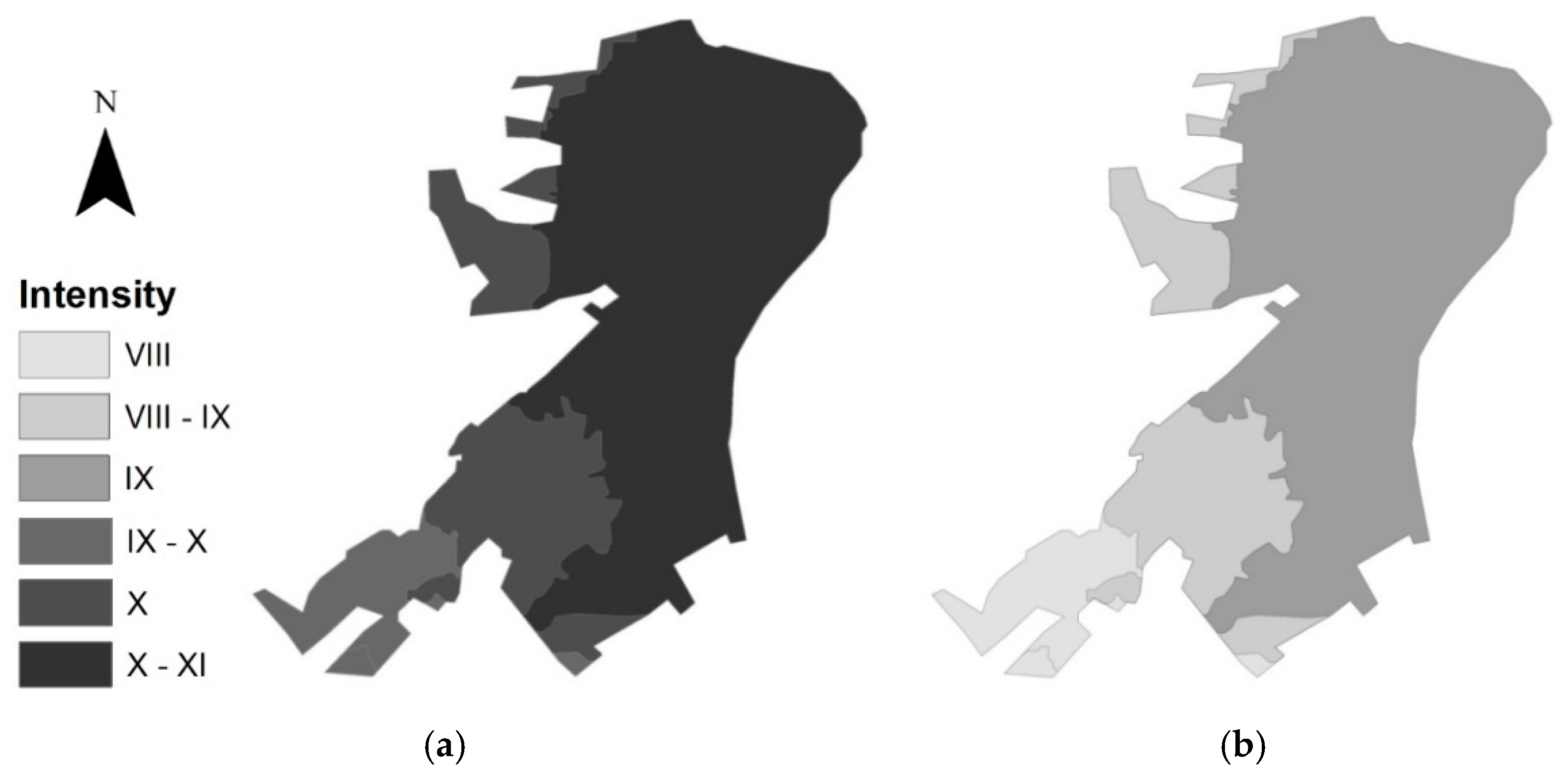
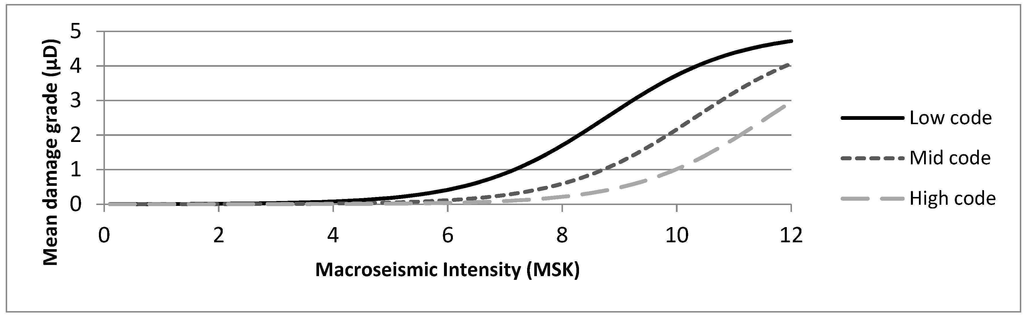
2. Seismic Intensity and Earthquake Scenarios
2.1. Earthquake Scenarios
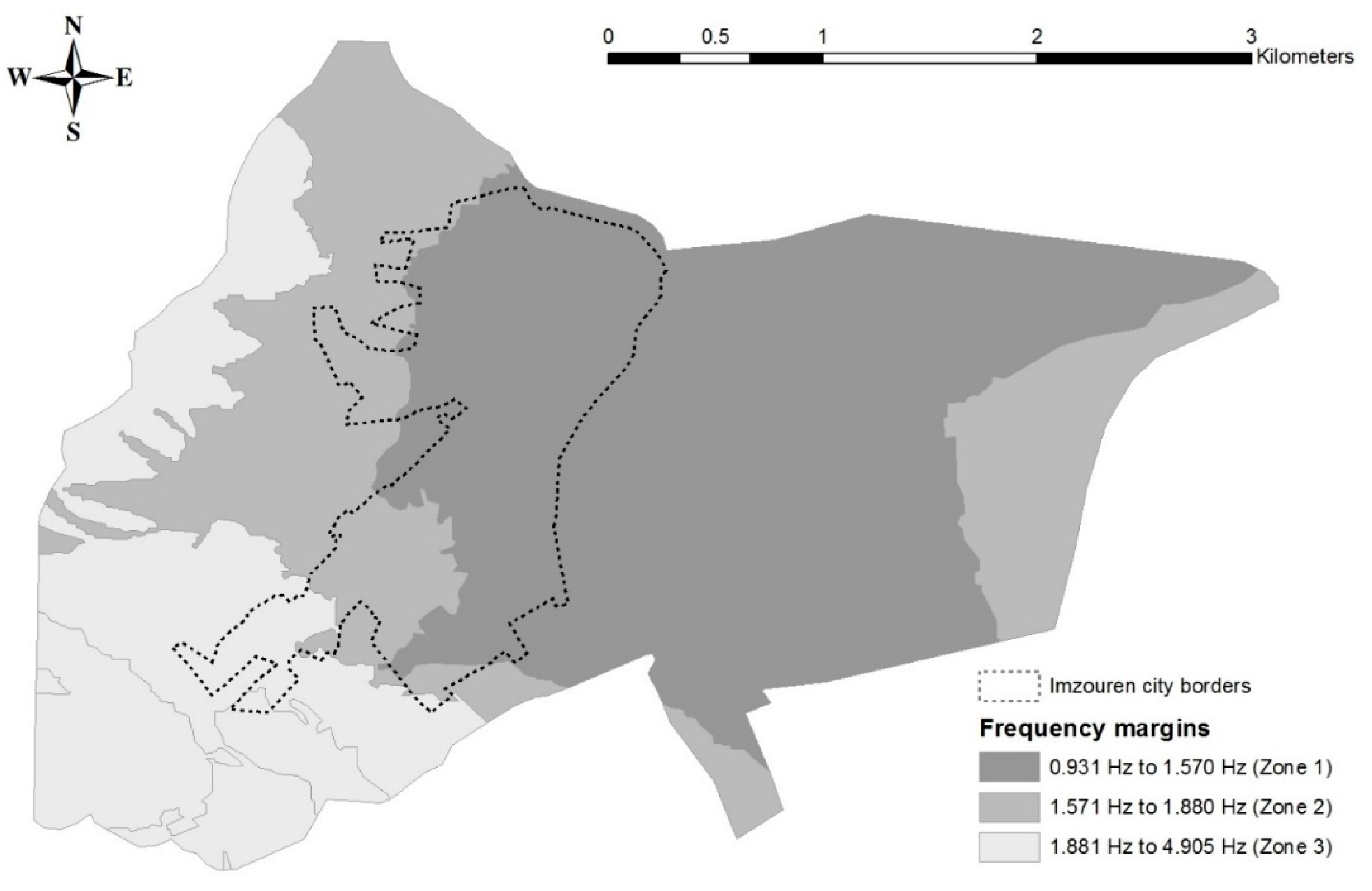
2.2. Site Effects
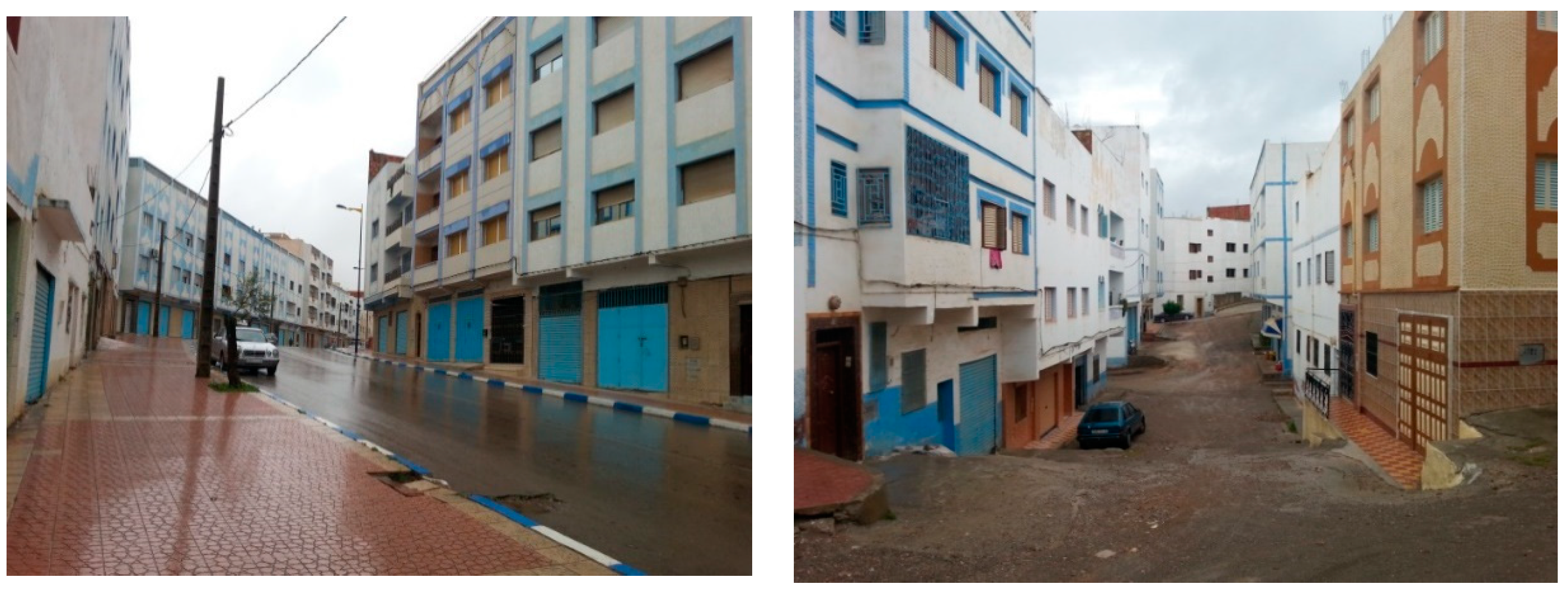
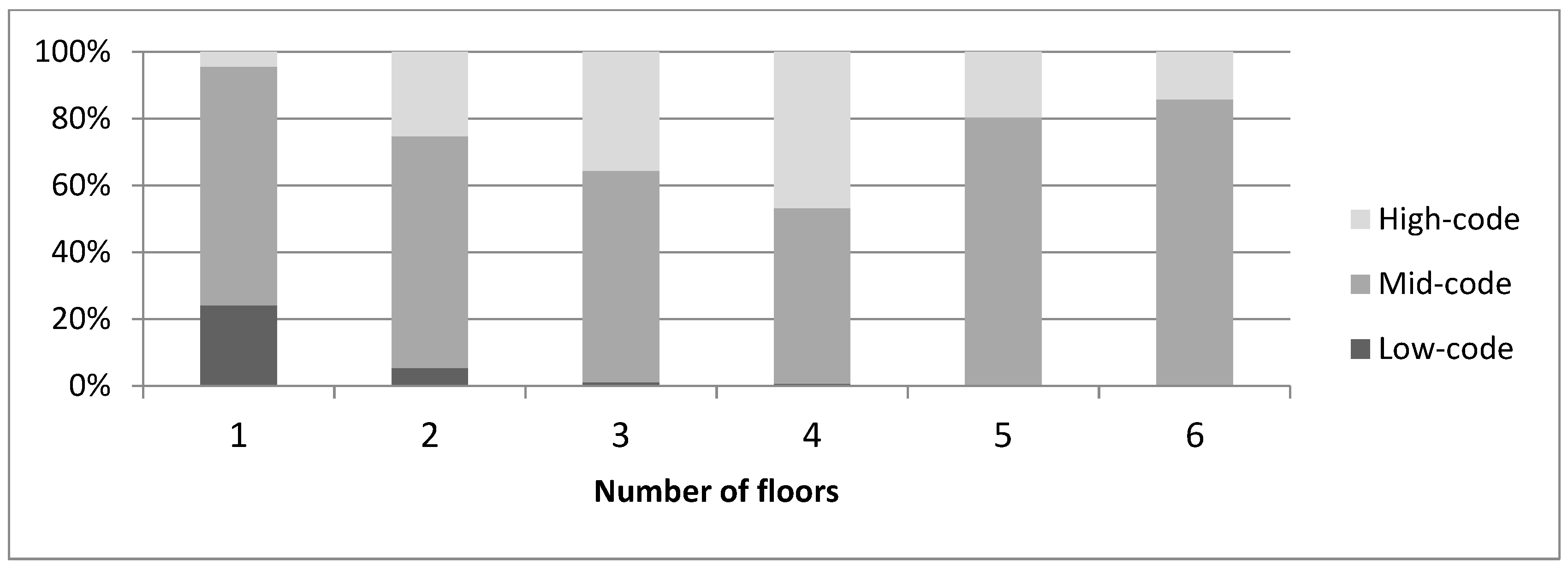
3. Description and Classification of Imzouren Building Inventory
- The 1960 event: Agadir was struck by one of the most destructive earthquakes in the 20th century [32] on 29 February 1960, causing more than 12,000 fatalities. A first seismic standard resulted from the studies and investigations in site, named “Agadir Standard”. Without a proper seismic code, the Moroccan construction has been greatly affected by this standard.
- The 1994 event: A violent earthquake () struck the region of Al Hoceima, causing casualties and extensive damage [28,33]. Constructive measures have been taken post-earthquake to protect and reinforce buildings in the Rif region, based on the PS92 [22] and BAEL 91 [21]. These decisions were applied after 1994 in Al Hoceima, Imzouren and surrounding towns and, subsequently, contributed to developing the first national seismic code known as R.P.S. 2000 [23].
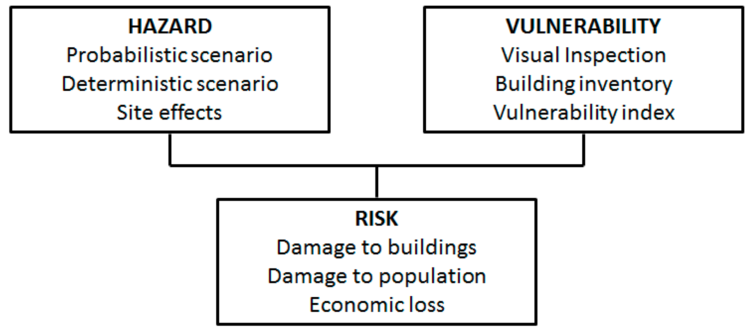
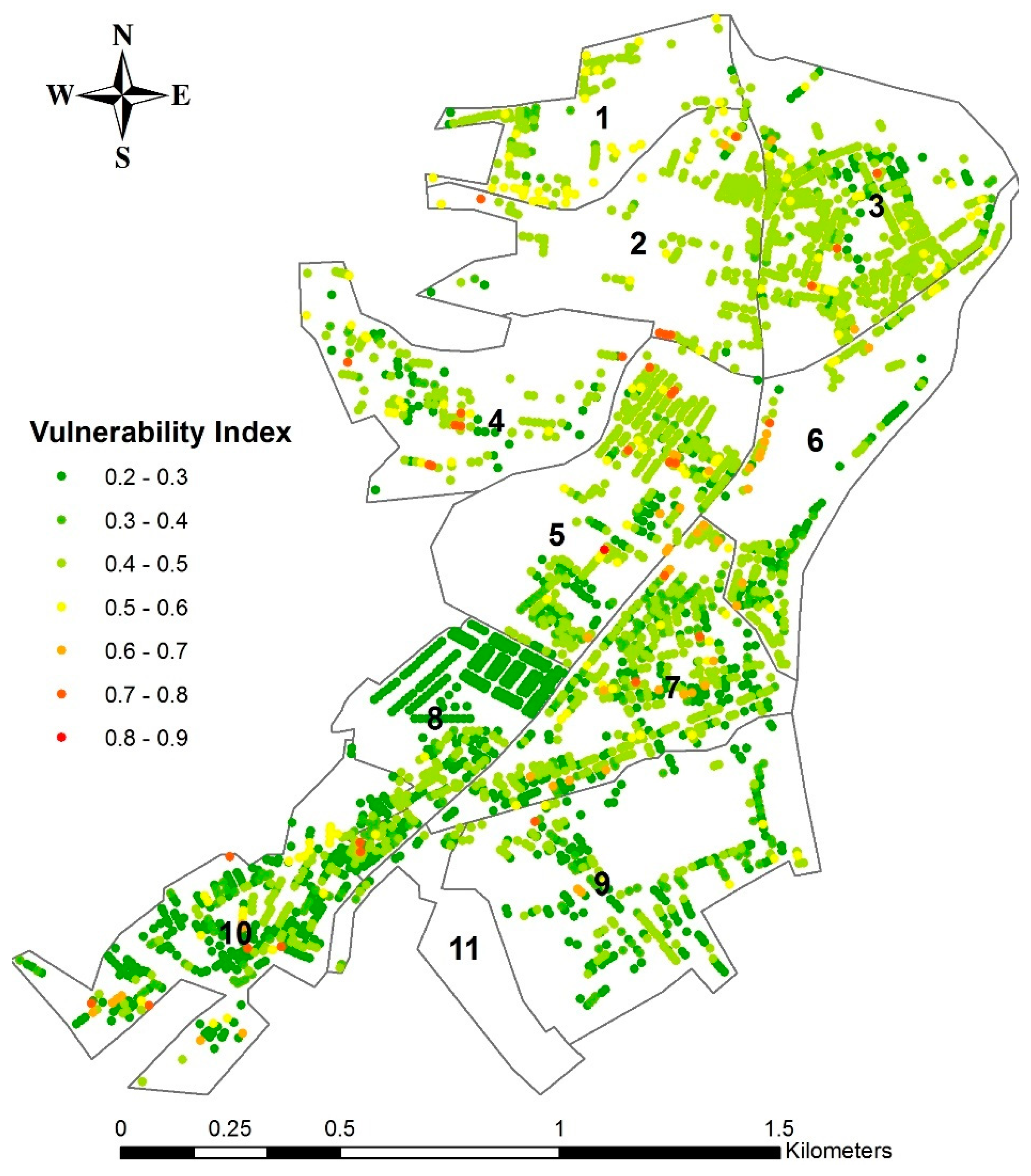
4. Seismic Vulnerability using the Vulnerability Index Method
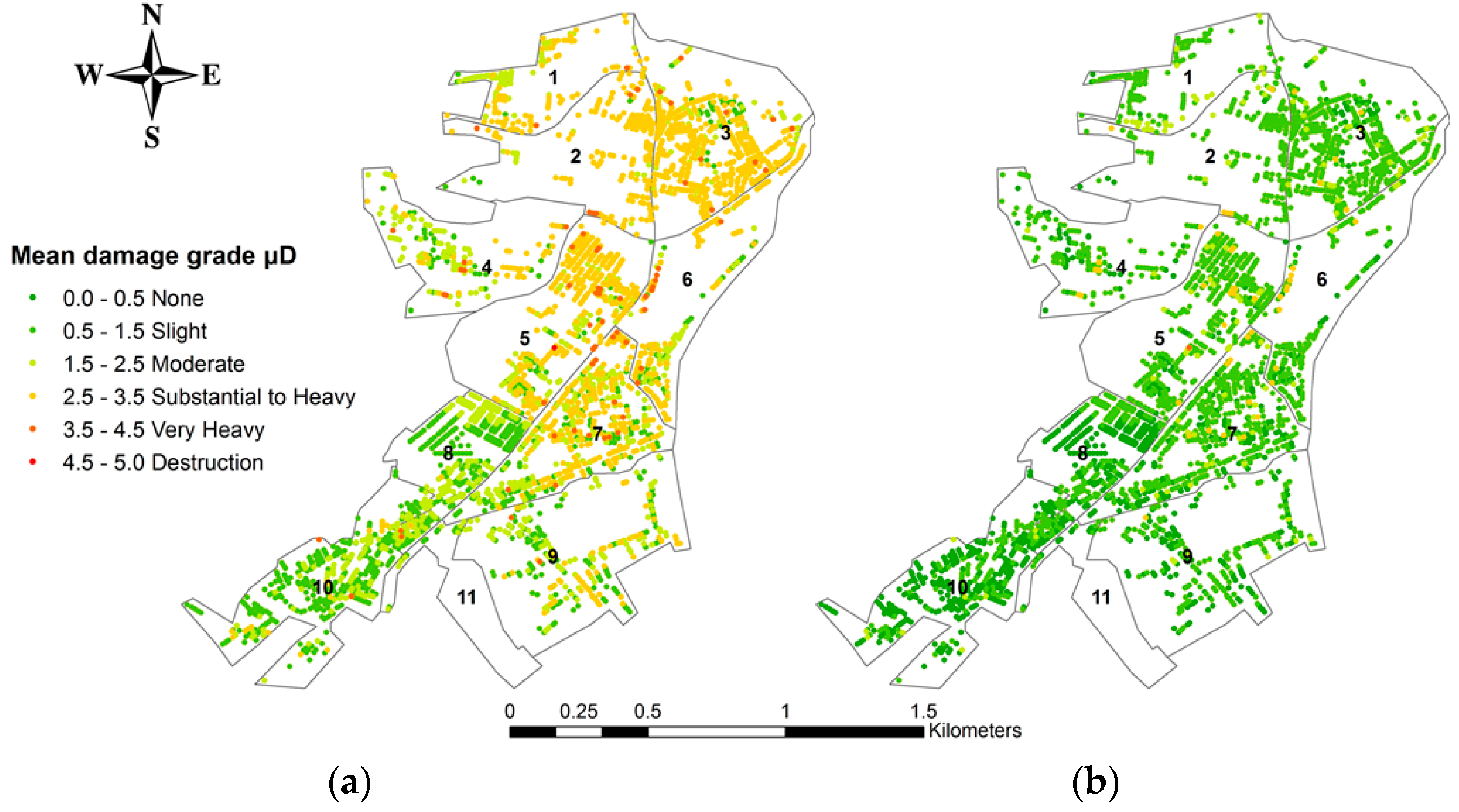
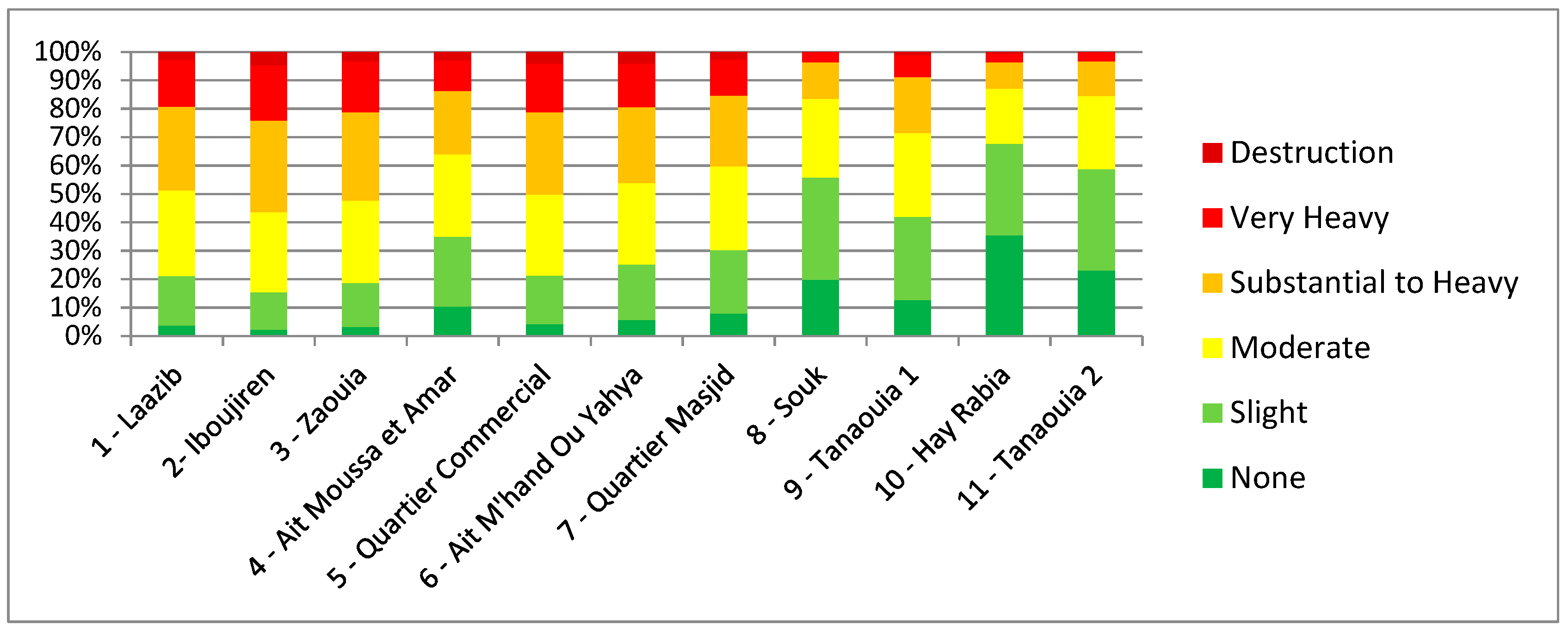
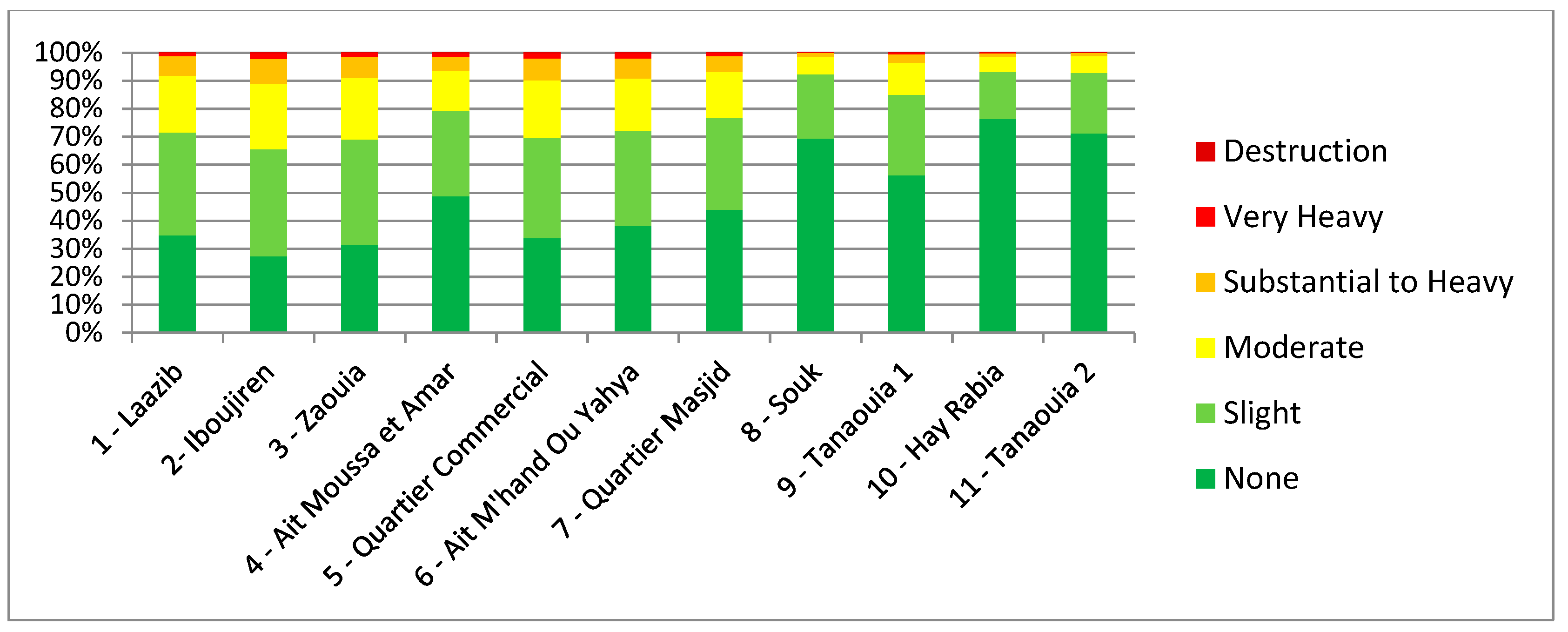
5. Seismic Risk and Loss Scenarios
5.1. Direct Damage
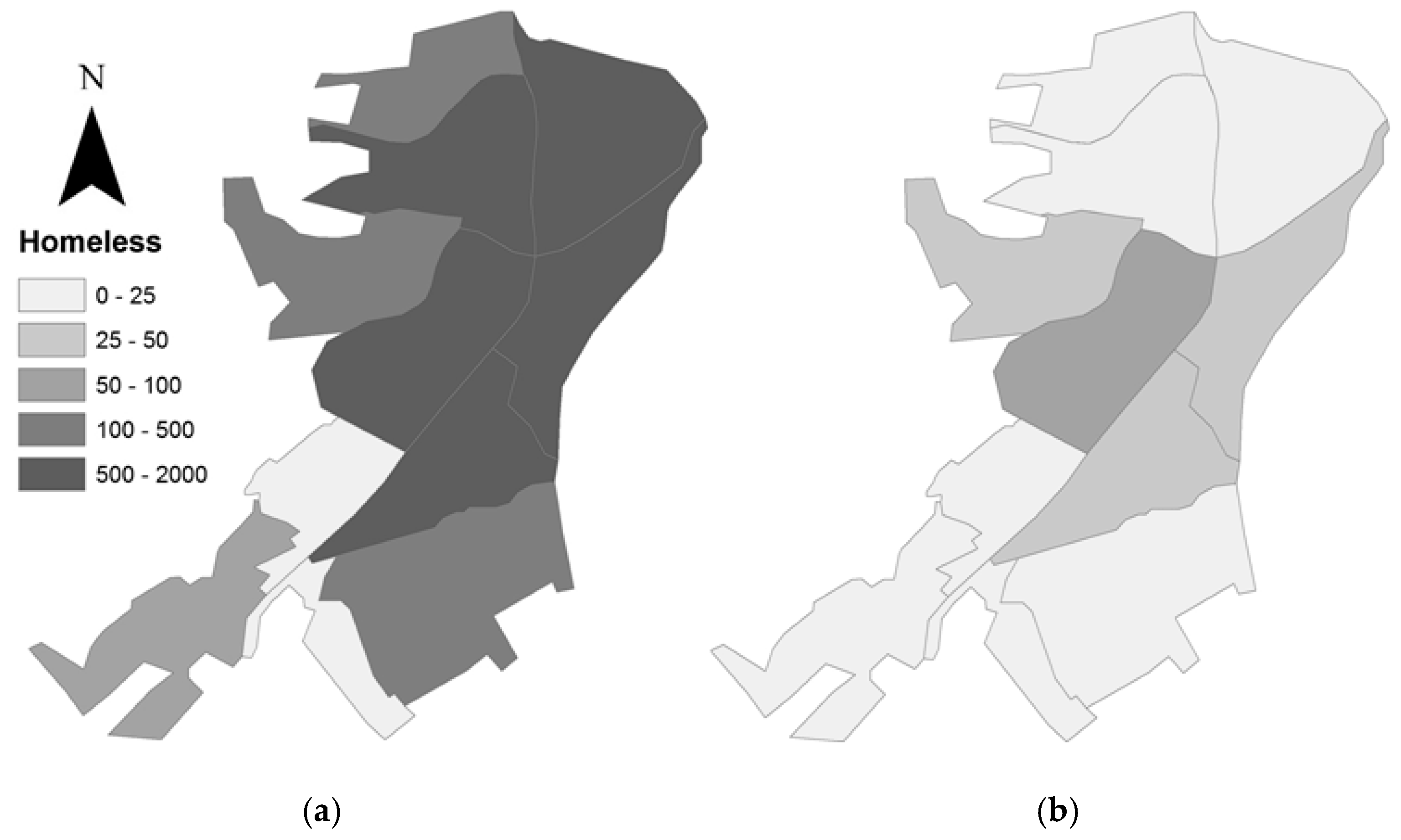
5.2. Harm to Population
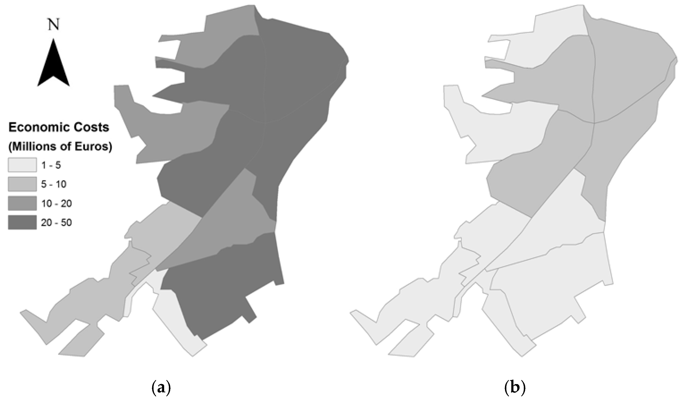
5.3. Economic Cost
6. Discussion
- Control of the mechanical characteristics of the existing buildings suspects of construction defects;
- Planning a seismic microzonation of the city using Vs30;
- Updating the seismic standard in the region of Al Hoceima, by adding response spectra for the cities and fragility curves for the typical structures;
- Increasing the level of preparedness of disaster and rising societal awareness of seismic risk.
7. Conclusions
Author Contributions
Funding
Conflicts of Interest
References
- Faccioli, E.; Pessina, V.; Calvi, G.M.; Borzi, B. A Study on Damage Scenarios for Residential Buildings in Catania City. J. Seismol. 1999, 3, 327–343. [Google Scholar] [CrossRef]
- Bertero, R.D.; Bertero, V.V. Performance-based seismic engineering: The need for a reliable conceptual comprehensive approach. Earthq. Eng. Struct. Dyn. 2002, 31, 627–652. [Google Scholar] [CrossRef]
- Zou, X.K.; Wang, Q.; Li, G.; Chan, C.M. Integrated reliability-based seismic drift design optimization of base-isolated concrete buildings. J. Struct. Eng. 2010, 136, 1282–1295. [Google Scholar] [CrossRef]
- Castaldo, P.; Palazzo, B.; Ferrentino, T. Seismic reliability-based ductility demand evaluation for inelastic base-isolated structures with friction pendulum devices. Earthq. Eng. Struct. Dyn. 2017, 46, 1245–1266. [Google Scholar] [CrossRef]
- McGuire, R. Scenario earthquakes for loss studies based on risk analysis. In Proceedings of the 5th International Conference on Seismic Zonation, Nice, France, 17–19 October 1995; pp. 1325–1333. [Google Scholar]
- Cherkaoui, T.; Hatzfeld, D.; Jebli, H.; Medina, F.; Caillot, V. Etude microsismique de la région d’Al Hoceima. Bull. Inst. Sci. Rabat 1990, 4, 25–34. [Google Scholar]
- El Alami, S.O.; Tadili, B.A.; Cherkaoui, T.E.; Medina, F.; Ramdani, M.; Ait Brahim, L.; Harnafi, M. The Al Hoceima earthquake of May 26, 1994 and its aftershocks: A seismotectonic study. Ann. Geophys. 1998, 41, 519–537. [Google Scholar]
- Bezzeghoud, M.; Buforn, E. Source parameters of the 1992 Melilla (Spain, Mw = 4.8), 1994 Al Hoceima (Morocco Mw = 5.8) and Mascara (Algeria, Mw = 5.7) earthquakes and seismotectonic implications. Bull. Seismol. Soc. Am. 1999, 89, 359–372. [Google Scholar]
- Jabour, N.; Kasmi, M.; Menzhi, M.; Birouk, A.; Hni, L.; Hahou, Y.; Timoulali, Y.; Bedrane, S. The February 24th, 2004 Al Hoceima Earthquake; Newsletter of European-Mediterranean Seismological Centre: Essonne, France, 2004. [Google Scholar]
- Douiri, A. Thèse: Etude de L’aléa Sismique dans la Ville d’Imzouren: Effets de Site et la Vulnérabilité Sismique des Édifices. Ph.D. Thesis, FST Tanger, University Abdelmalek Essaâdi, Tétouan, Morocco, 2014. [Google Scholar]
- Calvert, A.; Gomez, F.; Seber, D.; Barazangi, M.; Jabour, N.; Ait Brahim, L.; Demnati, A. An Integrate Geophysical Investigation of Recent Seismicity in the Al-Hoceima Region of North Morocco. Bull. Seismol. Soc. Am. 1997, 87, 637–651. [Google Scholar]
- El Mouraouah, A.; Iben brahim, A.; Kasmi, M.; Birouk, A.; El M’rabet, E.M.; Zouine, R.; El Mouraouah, E.A.; Toto, M.; Benammi, M.; Hafid, S.; et al. Le séisme d’Al Hoceima du 24 Février 2004. Surveillance Sismique et Analyse Préliminaire. Situation au 31 mai 2004; CEPRIS-CNRST: Rabat, Morocco, 2004; 162p, ISBN 9981-41-007-01. [Google Scholar]
- Hahou, Y.; Jabour, N.; Oukemeni, D.; El Wartiti, M.; Nakhcha, C. The Earthquake of 26 May 1994, Al Hoceima, Morocco; Intensity Distribution and Macroseismic Epicenter. Seismol. Res. Lett. 2004, 75, 51–58. [Google Scholar] [CrossRef]
- Stich, D.; Mancilla, F.; Baumont, D.; Morales, J. Source analysis of the Mw 6.3 2004 Al Hoceima earthquake (Morocco) using regional apparent source time functions. J. Geophys. Res. 2005, 110. [Google Scholar] [CrossRef]
- Biggs, J.; Bergman, E.; Emmerson, B.; Funning, G.; Jackson, J.; Parsons, B.; Wright, T. Fault Identification for Buried Strike-Slip Earthquakes using InSAR: The 1994 and 2004 Al Hoceima, Morocco Earthquakes. Geophys. J. Int. 2006, 166, 1347–1362. [Google Scholar] [CrossRef]
- Cakir, Z.; Meghraoui, M.; Akoglu, A.M.; Jabour, N.; Belabbes, S.; Ait-Brahim, L. Surface Deformation Associated with the Mw 6.4, 24 February 2004 Al Hoceima, Morocco, Earthquake Deduced from InSAR: Implications for the Active Tectonics along North Africa. Bull. Seismol. Soc. Am. 2006, 96, 59–68. [Google Scholar] [CrossRef]
- Tahayt, A.; Feigl, K.L.; Mourabit, T.L.; Rigo, A.; Reilinger, R.; McClusky, S.; Fadil, A.; Berthier, E.; Dorbath, L.; Serroukh, M.; et al. The Al Hoceima (Morocco) earthquake of 24 February 2004, analysis and interpretation of data from ENVISAT ASAR and SPOT5 validated by ground-based observations. Remote Sens. Environ. 2009, 113, 306–316. [Google Scholar] [CrossRef]
- Van Der Woerd, J.; Dorbath, C.; Ousadou, F.; Dorbath, L.; Delouis, B.; Jacques, E.; Tapponnier, P.; Hahou, Y.; Menzhi, M.; Frogneux, M.; et al. The Al Hoceima Mw 6.4 earthquake of 24 February 2004 and its aftershocks sequence. J. Geodyn. 2014, 77, 89–109. [Google Scholar] [CrossRef]
- Goula, X.; Gonzalez, M. Visite Technique à la Zone Endommagé par le Séisme d’Al-Hoceima du 24 Février 2004; ICC-GS-192/2004 (fr), Institut Cartogra‘fic de Catalunya, Generalitat de Catalunya: Barcelona, Spain, 2004. [Google Scholar]
- RGPH. Recensement Général de la Population et de L’habitat 2004. Available online: http://www.hcp.ma/recensement-general-de-la-population-et-de-l-habitat-2004_a633.html (accessed on 1 September 2018).
- BAEL 91. Règles Techniques de Conception et de Calcul des Ouvrages et Constructions en Béton Armé Suivant la Méthode des États-Limites; Editions Eyrolles: Paris, France, 1992. [Google Scholar]
- PS92. Règles PS Applicables Aux Bâtiments; NF P 06-013-DTU Règles PS 92. December 1995. Available online: https://www.icab.fr/guide/ps92/ (accessed on 1 September 2018).
- R.P.S. 2000. Règlement de Construction Parasismique. Ministère de l’Aménagement du Territoire, de l’Urbanisme, de l’Habitat et de l’Environnement; Secrétariat d’Etat à l’Habitat: Rabat, Morocco, 2002.
- Cherif, S.E.; Chourak, M.; Abed, M.; Pujades, L. Seismic risk in the city of Al Hoceima (north of Morocco) using the vulnerability index method, applied in Risk-UE project. Nat. Hazards 2017, 85, 329–347. [Google Scholar] [CrossRef]
- R.P.S. 2000. Version 2011 Règlement de Construction Parasismique; Ministère de l’Habitat, de l’Urbanisme et de l’Aménagement de l’Espace: Rabat, Morocco, 2011.
- Bird, J.F.; Bommer, J.J. Earthquake Losses due to Ground Failure. Eng. Geol. 2004, 75, 147–179. [Google Scholar] [CrossRef]
- Talhaoui, A. Risques Géologiques et Activité Sismique Dans la Région d’Al Hoceima: Impact sur L’environnement et L’aménagement. Ph.D. Thesis, Faculty of Sciences University Rabat, Rabat, Morocco, 2005. 207p. [Google Scholar]
- RMSI. Morocco Natural Hazards Probabilistic Analysis and National Strategy Development; Earthquake Hazard Report; Department of Economic and General Affairs: Rabat, Morocco, 2012. [Google Scholar]
- Medvedev, S.V.; Sponheuer, W.; Karnik, V. Seismic Intensity Scale Version MSK 1964; United Nation Educational, Scientific and Cultural Organization: Paris, France, 1965; p. 7. [Google Scholar]
- Douiri, A.; Mourabit, T.; Cheddadi, A.; Chourak, M. Pertinence de la méthode H/V «bruit de fond» pour l’évaluation de l’effet de site dans la ville d’Imzouren (Rif central, Maroc). Notes Mém. Serv. Géol. 2014, 577, 1–6. [Google Scholar]
- Faccioli, E. Seismic hazard assessment for derivation of earthquake scenarios in Risk-UE. Bull. Earthq. Eng. 2006, 4, 341–364. [Google Scholar] [CrossRef]
- Coburn, A.; Spence, R. Earthquake Protection, 2nd ed.; Wiley: Chichester, UK, 2002. [Google Scholar]
- Akoglu, A.M.; Cakir, Z.; Meghraoui, M.; Belabbes, S.; El Alami, S.O.; Ergintav, S.; Akyuz, H.S. The 1994–2004 Al Hoceima (Morocco) earthquake sequence: Conjugate fault ruptures deduced from InSAR. Earth Planet Sci. Lett. 2006, 252, 467–480. [Google Scholar] [CrossRef]
- Benedetti, D.; Petrini, V. Sulla Vulnerabilità Di Edifici in Muratura: Proposta Di Un Metodo Di Valutazione. L’industria Delle Costr. 1984, 149, 66–74. [Google Scholar]
- GNDT. Seismic Risk of Public Buildings Part 1—Methodology Aspects. GNDT-CNR Report. 1993. Available online: https://emidius.mi.ingv.it/GNDT2/Pubblicazioni/Monografie_disponibili.htm (accessed on 11 December 2018). (In Italian).
- Lantada, N.; Irizarry, J.; Barbat, A.H.; Goula, X.; Roca, A.; Susagna, T.; Pujades, L.G. Seismic hazard and risk scenarios for Barcelona, Spain, using the Risk-UE vulnerability index method. Bull. Earthq. Eng. 2010, 8, 201–229. [Google Scholar] [CrossRef]
- Milutinoviç, Z.V.; Trendafiloski, G.S. WP04: Vulnerability of Current Buildings Handbook. RISK-UE Project: An Advanced Approach to Earthquake Risk Scenarios with Applications to Different European Towns; Contract No. EVK4-CT-2000-00014; Institute of Earthquake Engineering and Engineering Seismology (IZIIS): Skopje, Macedonia, 2003. [Google Scholar]
- Mouroux, P.; Bertrand, M.; Bour, M.; Brun, B.L.; Depinois, S.; Masure, P.; Risk-UE Team. The European Risk-UE project: An advanced approach to earthquake risk scenarios. In Proceedings of the 13th World Conference Earthquake Engineering, Vancouver, BC, Canada, 1–6 August 2004. [Google Scholar]
- Pitilakis, K.; Alexoudi, M.; Argyroudis, S.; Anastasiadis, A. Seismic risk scenarios for an efficient seismic risk management: The case of Thessaloniki (Greece). Adv. Earthq. Eng. Urban Risk Reduct. 2006, 66, 229–244. [Google Scholar] [CrossRef]
- Calvi, G.M.; Pinho, R.; Magenes, G.; Bommer, J.J.; Restrepo-Vélez, L.F.; Crowley, H. Development of seismic vulnerability assessment methodologies over the past 30 years. ISET J. Earthq. Technol. 2006, 43, 75–104. [Google Scholar]
- Giovinazzi, S.; Lagomarsino, S. WP04: Guidelines for the Implementation of the I Level Methodology for the Vulnerability Assessment of Current Buildings; Risk-UE Project: Genoa, Italy, 2002. [Google Scholar]
- Grünthal, G. European Macroseismic Scale 1998; Centre Européen de Géodynamique et de Séismologie: Luxemburg, 1998. [Google Scholar]
- Lagomarsino, S.; Giovinazzi, S. Macroseismic and mechanical models for the vulnerability and damage assessment of current buildings. Bull. Earthq. Eng. 2006, 4, 415–443. [Google Scholar] [CrossRef]
- HAZUS. Earthquake Loss Estimation Methodology Technical Manual; National Institute of Building Sciences for Federal Emergency Management Agency (FEMA): Washington, DC, USA, 1999.
- Fuller, S. Life-Cycle Cost Analysis (LCCA). Whole Building Design Guide; WBDG: Washington, DC, USA, 2010. [Google Scholar]
- NatCatSERVICE. Natural Disasters 2004–10 Deadliest Natural Disasters; Munich Re, Geo Risks Research: Munich, Germany, 2008. [Google Scholar]
- Cherkaoui, T.E.; Harnafi, M. Le Séisme d’Al Hoceima du 24 Février 2004; Travail Collectif National Sur: Région de Taza-Al Hoceima-Taounate, Ressources et Stratégies de Développement, Faculté Polydisciplinaire de Taza: Taza, Morocco, 2005; pp. 27–38. [Google Scholar]


| Housing Types | Number | % |
|---|---|---|
| Villa | 9 | 0.2 |
| Apartment | 4 | 0.1 |
| Traditional Moroccan house | 74 | 1.4 |
| Modern Moroccan house | 4834 | 93.9 |
| Slum | 20 | 0.4 |
| Rural dwelling | 23 | 0.4 |
| Others | 183 | 3.6 |
| Housing Occupation | Number | % |
|---|---|---|
| Total dwellings | 7471 | 100 |
| Occupied dwellings | 5122 | 68.6 |
| Vacant dwellings | 1492 | 20 |
| secondary or seasonal dwellings | 857 | 11.5 |
| Construction Period | Before 1960 | 1960–1994 | After 1994 |
|---|---|---|---|
| Code level | Low code | Medium code | High code |
| Label | District Name | Number of Inspected Buildings | MVI |
|---|---|---|---|
| 1 | Laazib | 131 | 0.44 |
| 2 | Iboujiren | 185 | 0.44 |
| 3 | Zaouia | 530 | 0.42 |
| 4 | Ait Moussa et Amar | 155 | 0.41 |
| 5 | Quartier Commercial | 396 | 0.41 |
| 6 | Ait M’hand Ou Yahya | 182 | 0.40 |
| 7 | Quartier Masjid | 478 | 0.38 |
| 8 | Souk | 339 | 0.31 |
| 9 | Tanaouia 1 | 267 | 0.33 |
| 10 | Hay Rabia | 392 | 0.32 |
| 11 | Tanaouia 2 | 22 | 0.32 |
| Typology | M2 (%) | M3 (%) | M4 (%) | M5 (%) | |||
|---|---|---|---|---|---|---|---|
| Light Injuries | Injuries Requiring Hospitalization | Life-Threatening Cases | Fatalities | ||||
| Values for reinforced concrete buildings | 75 | 50 | 10 | 40 | 10 | 40 | 90 |
| Label | District Name | Light Injuries | Injuries Requiring Hospitalization | Life-Threatening Cases | Fatalities |
|---|---|---|---|---|---|
| 1 | Laazib | 12 | 13 | 12 | 13 |
| 2 | Iboujiren | 36 | 37 | 36 | 37 |
| 3 | Zaouia | 31 | 32 | 31 | 32 |
| 4 | Ait Moussa et Amar | 7 | 7 | 7 | 7 |
| 5 | Quartier Commercial | 26 | 27 | 26 | 27 |
| 6 | Ait M’hand Ou Yahya | 15 | 16 | 15 | 16 |
| 7 | Quartier Masjid | 10 | 10 | 10 | 10 |
| 8 | Souk | 1 | 1 | 1 | 1 |
| 9 | Tanaouia 1 | 5 | 5 | 5 | 5 |
| 10 | Hay Rabia | 0 | 0 | 0 | 0 |
| 11 | Tanaouia 2 | 0 | 0 | 0 | 0 |
| Total | 143 | 147 | 143 | 147 | |
© 2018 by the authors. Licensee MDPI, Basel, Switzerland. This article is an open access article distributed under the terms and conditions of the Creative Commons Attribution (CC BY) license (http://creativecommons.org/licenses/by/4.0/).
Share and Cite
Cherif, S.-e.; Chourak, M.; Abed, M.; Douiri, A. Potential Seismic Damage Assessment of Residential Buildings in Imzouren City (Northern Morocco). Buildings 2018, 8, 179. https://doi.org/10.3390/buildings8120179
Cherif S-e, Chourak M, Abed M, Douiri A. Potential Seismic Damage Assessment of Residential Buildings in Imzouren City (Northern Morocco). Buildings. 2018; 8(12):179. https://doi.org/10.3390/buildings8120179
Chicago/Turabian StyleCherif, Seif-eddine, Mimoun Chourak, Mohamed Abed, and Abdelhalim Douiri. 2018. "Potential Seismic Damage Assessment of Residential Buildings in Imzouren City (Northern Morocco)" Buildings 8, no. 12: 179. https://doi.org/10.3390/buildings8120179
APA StyleCherif, S.-e., Chourak, M., Abed, M., & Douiri, A. (2018). Potential Seismic Damage Assessment of Residential Buildings in Imzouren City (Northern Morocco). Buildings, 8(12), 179. https://doi.org/10.3390/buildings8120179