Article

Assessing the Spatial Heterogeneity of Village Homestead Improvement Potential: Village Environment and Multidestination Urban Housing Purchases

1
Institute of Land and Urban-Rural Planning, Huaiyin Normal University, Huai’an 223300, China
2
Department of Urban and Regional Development, Hanyang University, Seoul 04763, Republic of Korea
3
School of Art & Design, Guangzhou College of Commerce, Guangzhou 511363, China
4
School of Civil Engineering, Jiaying University, Meizhou 514015, China
*
Authors to whom correspondence should be addressed.
These authors contributed equally to this work.
Buildings 2026, 16(17), 3381; https://doi.org/10.3390/buildings16173381
Submission received: 8 July 2026 / Revised: 20 August 2026 / Accepted: 21 August 2026 / Published: 25 August 2026
(This article belongs to the Special Issue Research on Health, Wellbeing, and Urban Design—2nd Edition)

Abstract

Understanding the interactions between rural household decision-making behavior and the environment is critical to promoting sustainable rural development. Analyzing the interrelationship between multidestination urban housing purchases, homestead improvement potential, and village environments can provide a theoretical basis for formulating rural revitalization policies. This study uses full-sample household survey data, applying multiscale geographically weighted regression to assess spatial variability and K-means clustering to categorize effects. The findings reveal significant spatial heterogeneity in village homestead improvement potential, most strongly associated with locational attributes, water network density, residential quality, and social factors. The association between multidestination urban housing purchases and improvement potential varies by destination: township purchases are positively associated with it, whereas purchases in county centers and beyond show negative associations. The spatial variability of different factors is significant, allowing villages to be classified into five zones based on dominant factors. Tailored, zone-specific policy directions—developing a county-level dual-core urban system, promoting rural tourism, and encouraging concentrated local habitation—are proposed as testable hypotheses for supporting in situ urbanization and homestead land improvement.

1. Introduction

Following the reform and opening-up in 1978, China has rapidly advanced in terms of urbanization and industrialization, swiftly transitioning from an agrarian society to an urban one and from a land-dependent society to a mobile society [1,2]. Over the past four decades, more than 400 million people have migrated from rural areas to urban areas [3]. The lag in population urbanization behind land urbanization has led to the extensive underutilization of rural land, especially homestead land, with issues such as abandoned land, multiple homes per household, and oversized plots that urgently need to be addressed [4,5,6,7]. This phenomenon has resulted in significant waste of village land resources, which has reduced the economic value of land and exerted considerable pressure on the village environment, thereby affecting the quality of life of rural households and the ecological environment and ultimately hindering rural revitalization [8,9,10]. Moreover, rural homesteads have potential for urban expansion, as arable land, infrastructure development, and market transactions can be expanded [11,12,13]. Therefore, the rational improvement of village homesteads is crucial for the sustainable development of land resources and is a key prerequisite for integrated urban-rural development and rural revitalization [14,15,16].
In the process of rural transformation and development in China, the uneven distribution of resources and opportunities has led to increasingly significant disparities among different regions [11,17]. The Chinese government has recognized these regional differences and has initiated diverse pilot projects in selected areas, resulting in various models such as Tianjin’s “Homestead for Housing,” Ningxia’s “Land for Pension,” and Chongqing’s “Land Ticket” [18,19]. However, the overall effectiveness of homestead improvement has been limited, with challenges arising in the implementation of many policies [20,21]. This is attributed to the variability in environmental factors such as natural resources, geographic location, economic conditions, and social environments across regions, which influence rural households’ perceptions and expectations of homestead land value; this, in turn, leads to differences in village homestead improvement potential [22,23]. Since homesteads are vital potential assets for rural revitalization, clarifying the effects of different village environments on homesteads and identifying appropriate remediation pathways are crucial for local governments to achieve rural revitalization. Additionally, constructing a theoretical framework based on the heterogeneity of village environments to assess village homestead improvement is essential for enhancing the theory of sustainable land development.
The Central No. 1 Document from 2021 to 2024 has consistently promoted the cautious and steady advancement of homestead withdrawal system reform in China, with the principle of voluntariness serving as the foundational basis for its implementation. The potential for village homestead improvement is predicated upon the willingness of rural households to relinquish their homestead rights, and their intentions represent the most authentic gauge of this potential [4,24]. However, extensive surveys on the willingness of households to withdraw from homesteads reveal a reluctance to do so, with 50–70% of households being disinclined to give up their land rights [8,25]. In the process of promoting village homestead remediation, local governments inevitably face the challenge of identifying which types of families are best suited to withdraw from the homestead system. Return migrants’ ambivalent attachment to rural places has been documented internationally, and in China this takes the form of “semiurbanization,” in which a significant portion of the rural migrant population oscillates between rural life and complete urbanization [26,27]. The inability of this migrant population to afford urban housing often leads to them being marginalized within cities [28], so their homesteads become a critical safety net for their potential return to rural life; thus, they have apprehensions about relinquishing this land [29]. As the reform of the homestead system progresses, the government is increasingly recognizing the fundamental role of homesteads in social security [30], with policy focuses shifting toward households that have settled in urban areas [31,32]. However, the following question remains: what is the impact of urban housing ownership on the willingness of these households to participate in village homestead land remediation? Does purchasing urban housing in different destinations yield varying impacts? Therefore, responding to farmers’ behavioral decision-making has become the key to promoting the current policy of improving village homesteads, as well as the basis for promoting the sustainable development of rural society.
In recent years, the academic community has increasingly focused on improving village homesteads. Scholars have conducted extensive research on the need for remediation [10,29], the estimation of its potential [24,33], the social effects post remediation [30,34], and the willingness of rural households to engage in these activities [4,8,35]. As the primary agents in village homestead improvement, rural households have been a focal point of attention. The potential for village homestead improvement, which is constructed from the perspective of rural household willingness, is considered a realistic reflection of the potential extent of remediation. The factors that influence rural household willingness are categorized into internal and external factors [11]. Internal factors include individual and family characteristics [36,37], household differentiation [20], identity [38,39,40], and labor mobility [39], while external environmental factors encompass the condition of the homestead land [41,42], policies [35,43], location [44,45], rural tourism [46,47,48], and urban housing purchases [36,47,49]. Most studies have employed questionnaire sampling surveys and widely used analytical models such as logit, probit, structural equation modeling (SEM) [45], theory of planned behavior (TPB), and the technology acceptance model (TAM) [50] to analyze the determinants of village homestead improvement potential. Although existing studies have made substantial contributions, there is still a need for deeper exploration in three key areas: 1. Village Environment Consideration: Current studies have paid limited attention to the village environment in which rural homesteads are located. The village environment acts as a spatial carrier for people’s willingness and actions related to homestead withdrawal. Rural household behavior is the result of interactions between humans and land, necessitating a clearer understanding of the link between the village environment and the improvement potential of village homesteads. 2. Impact of Urban Housing Purchases: Although urban housing serves as a substitute for homesteads, the real impact of different types of urban housing purchases on the willingness to participate in village homestead improvement has not been accurately assessed. 3. Sociological Perspective and Scale of Study: Most of the current research adopts a sociological perspective with a relatively large scale of study units, primarily relying on sampling survey data. However, conclusions drawn from macroscale sampling data may not accurately reflect the true intentions of rural households at the microscale, which may lead to misinterpretations of the impact effects and undesirable outcomes.
Against the background of the four earlier studies set out below, the contribution claimed for the present study is not a new label for an existing measure, and we do not present the dependent variable as a measurement innovation. What is new is the analytical chain and the use to which it is put. Village environmental elements and urban housing purchases disaggregated by destination are treated jointly as explanatory dimensions; MGWR is used to estimate how the association between each of these dimensions and homestead improvement potential varies from village to village; the resulting vector of location-specific coefficients is then used as the feature space in which villages are grouped, so that villages sharing a similar profile of influences fall into the same group; and the resulting five groups are read through their dominant coefficients and translated into differentiated policy directions. The step that distinguishes this study from the earlier work is the last one: moving from describing spatial difference, or explaining household behaviour, to converting estimated spatial heterogeneity into an operational basis for zoned management. Whether the willingness item used here is identical in wording to that used in the earlier city-wide analysis is a question about the questionnaire rather than about the analysis, and we make no claim of measurement novelty either way; the novelty asserted here lies in the research question and in the policy-zoning use of the local coefficients.
Because the present study draws on a household survey that has also supported earlier work by members of the research team, we set out that relationship explicitly rather than leaving it to be inferred. Liu, Wang, He, Cao, Lyu and Li (2022) [51] mapped the spatial pattern of resettlement willingness at the village scale in a plain area of Huai’an and related it to accessibility. Wang, He and Choi (2024) [52] extended that work to 1382 villages across Huai’an City, organised the explanatory variables into four dimensions of the village environment, and used MGWR to show that the associations vary spatially; that study characterised spatial heterogeneity but did not translate the local estimates into a policy instrument. Wang, Pang and Choi (2023) [27] treated the destination of urban housing purchase itself as the outcome to be explained across 1307 villages, using spatial autocorrelation analysis, GeoDetector and OLS to identify where township, county-town, metropolitan and foreign purchases occur and why; homestead improvement potential was not examined there, and no coefficient-based zoning was constructed. Wang, Pang, Liu and He (2022) [53] examined inter-village differences in urban housing purchase in Lianshui County, a different study area with a different dependent variable. Taken together, this body of work establishes that resettlement-related intentions are spatially structured and that purchase destinations differ systematically, but it stops short of the question addressed here.
A further strand of the literature, which the present study draws on explicitly, concerns rural class differentiation. As off-farm employment and urban property ownership have spread unevenly, rural households have become internally stratified in income, occupation and asset position, and the sociological literature describes an emergent stratum of relatively affluent “amphibious” households that sustain a dual urban–rural existence rather than exiting the countryside altogether [20,31,32]. Differentiation matters for homestead improvement because it conditions what a homestead means to a household: for asset-rich households it may function as an appreciating asset, a social-security fallback and a marker of lineage and status, whereas for liquidity-constrained households it is more likely to be a resource that must be monetised in order to finance an urban move. Destination of urban housing purchase is plausibly correlated with these positions, since county-town property is markedly more expensive than township property. This literature has, however, rarely been brought together with the village-environment literature, and it is not yet clear how far differentiation is expressed at the village scale at which improvement policy is actually implemented.
Considering these aspects, this study constructs a theoretical analytical framework for village homestead improvement built on two explanatory dimensions: the elements of the village environment, and urban housing purchases disaggregated by destination. Using comprehensive survey data from the selected region, the study pursues three linked objectives. The first is to characterise the spatial structure of village homestead improvement potential and to test whether it is spatially clustered rather than varying smoothly with urban proximity. The second is to estimate, by means of the multiscale geographically weighted regression (MGWR) model, how the associations between the two explanatory dimensions and improvement potential vary across space, recognising that different processes may operate at different spatial scales. The third, which carries the principal contribution, is to use the vector of location-specific coefficients as the feature space for grouping villages, so that villages with similar profiles of influence are placed together, and then to read each group through its dominant coefficients in order to derive differentiated policy directions. Framed in this way, the study is an attempt to convert estimated spatial heterogeneity into a usable planning instrument rather than to document that heterogeneity for its own sake. Because the design is cross-sectional, the associations reported throughout are interpreted as patterns of covariation rather than as identified causal effects; this qualification is carried consistently through the results, the discussion and the statement of limitations. The findings and the derived zoning tool are intended to inform local policymaking and to offer transferable insights for land-use governance and rural revitalization in China and other developing nations.

2. Theoretical Framework and Research Hypotheses

2.1. Village Environmental Elements and Potential for Homestead Improvement

Initially established to offer a form of social security to farmers and maintain social stability in rural areas, China’s rural homestead land system has evolved in response to societal development and systemic reforms [54]. This evolution has gradually unlocked the multifaceted potential of homesteads, leading rural households to recognize their diverse values [23,55]. In addition to providing a place of residence and embodying residential security value, homesteads can generate economic development value through private property transactions, usage rights trading, and compensated exits [56]. Additionally, homesteads hold sentimental value that is tied to notions of “ancestral home,” community bonds, and rural attachment, such as the desire to return to one’s roots [30]. Households are inclined to voluntarily withdraw from the homestead land system with compensation when the post-exit value surpasses the current value. Given that different village environments create varying homestead values [57], these environmental factors are crucial for determining the potential for village homestead improvement.
The locational and natural environments of a village affect its potential for homestead improvement and value [22]. Villages near urban areas may benefit from public services and economic development through homestead leasing and may be incorporated into expanding cities, leading to fewer households willing to withdraw from homesteads [25,45]. In contrast, more remote villages show greater spatial heterogeneity. Some develop tourism or industry, enhancing homestead value. However, other villages that are distant from development centers face issues such as a lack of public services and high resource mobility costs, leading to lower residential and economic homestead values and withdrawal. Natural environmental factors such as topography, water systems, and natural disasters also impact homestead value [58]. Rolling terrain and abundant water systems can enhance rural tourism and the village economy, while rugged terrain and dense water networks can reduce accessibility and hinder development, leading to decreased satisfaction with residential space. Natural disasters increase living risk and the uncertainty of rural economic returns, strengthening people’s willingness to withdraw from homesteads [59].
The economic and residential environment of a village shapes the living security and economic development value of homesteads, influencing rural households’ intentions. Economic factors include income levels, regional economic status, and industrial foundation [20]. As incomes rise, households can afford urban housing, increasing the likelihood of relocation and their willingness to withdraw from homesteads. However, households may anticipate greater economic value from their homesteads and retain them. A region’s economic level and industrial base impact livelihood and development. A weak industrial base and high opportunity costs can hinder industry-driven employment, driving relocation, while a strong economic level and robust industrial foundation enable in situ urbanization. Residential factors, including homestead land size, housing quality, and public infrastructure, influence residential and economic value [44]. In rural tourism areas, larger homesteads and superior housing quality enable “courtyard economy” activities, enhancing homestead value and discouraging withdrawal [7].
Both social and policy environment elements exist; the former has an amplifying effect on the direction of farmers’ behavioral decisions, and the latter can subconsciously affect farmers’ willingness. Over time, as rural communities evolve, villages develop relatively unified values and concepts within their organizational structures. This network of familiar social relations significantly impacts homestead improvement [11]. Thus, the mechanism through which the social environment affects the potential for village homestead improvement is manifested primarily in the degree of population aggregation and the extent of social connections [17]. Village settlements, which are formed based on kinship and geographical proximity, represent social network spaces where the level of population aggregation reflects the degree of social connectivity. Generally, settlements with higher degrees of connectivity exhibit lower willingness for homestead improvement. The impact mechanism of the policy environment is mainly reflected in rigid institutional frameworks at the national level and planning guidance policies at the local government level [35]. The central government of China prioritizes ecological protection in rural areas, delineating ecological conservation zones. If a village falls within such a zone, the development of its living facilities will be restricted, which compels households to relocate to find a better living environment. Planning guidance policies primarily concern local governments’ visions for future village development. Local authorities often categorize villages into key villages, characteristic villages, and general villages, directing orderly population aggregation toward key and characteristic villages [53]. These categorizations influence rural households’ decisions regarding homestead improvement, as they respond to the positioning set by local government planning.
Notably, the potential for village homestead improvement is the result of the combined influence of multidimensional environmental factors, characterized by interactive pathways of influence and spatial heterogeneity in impact effects. From the perspective of pathways of influence, the value of a homestead is typically not dominated by a single factor; instead, it emerges from the interplay of multiple environmental elements. Regarding the heterogeneity of impact effects, the sensitivity of homestead value to various factors varies across different spatial contexts, which leads to significant spatial heterogeneity in the effects of these factors.
Two clarifications about how this framework is to be read follow from the design of the study. First, the framework is stated in mechanistic language because that is how the expectations are derived, but the empirical model that follows is estimated on a single cross-section and therefore identifies patterns of association rather than causal effects. Wherever the results and the discussion describe an environmental element as being related to improvement potential, that statement should be read as covariation at the village scale. Second, this qualification applies with particular force to the element that captures vacant and abandoned farmhouses. Vacancy plausibly reflects the accumulated out-migration of earlier cohorts, and it is equally plausible that villages whose remaining households are more willing to leave will generate further vacancy over time. The two are therefore likely to be co-determined, and a cross-sectional specification cannot separate the two directions of the relationship. We return to this point in the discussion of limitations rather than treating the estimated coefficient as the effect of vacancy on willingness.

2.2. Urban Housing Purchases and Homestead Improvement Potential

Owning urban housing while retaining rural homestead land epitomizes a dual-residence phenomenon for rural households amidst urban-rural migration [32], paralleling the significance of rural homesteads. For these households, urban housing embodies a nexus of residential utility, investment opportunity, and social integration [31,60]. Residentially, urban housing offers rural households a city dwelling when they withdraw from their homesteads, easing their urban living costs and bolstering their propensity to relinquish rural land [61]. Economically, urban property ownership often indicates superior financial standing. However, the investment effect may dampen the willingness to exit homestead land, as the relative value of wealth from compensation diminishes against prior property investments, and expectations of property rights appreciation encourage the retention of homestead land as a potential asset. Socially, urban housing acquisition signifies a commitment to urban life, enhancing social welfare parity with urban residents and diluting rural attachments [53]. This reduced emotional reliance on rural homesteads is associated with a greater stated willingness to withdraw from them. These multifaceted urban housing effects culminate in the first hypothesis for empirical testing:
H1. 
Overall, the association between urban housing purchases and the potential for village homestead improvement is expected to be weak and not statistically significant, because purchases made in different destinations are associated with improvement potential in offsetting directions.
Urban housing purchases, which are indicative of urbanization, exhibit spatially heterogeneous effects, suggesting that multidestination urban housing purchases by households from different villages correspond to varied outcomes. These purchases are categorized into local (further divided into township and county housing purchases) and nonlocal, each with distinct residential, investment, and social effects. Township housing purchases, which are appealing due to lower costs and a familiar sociocultural environment, typically attract households with modest means and lower education levels. These purchases facilitate educational access for children and allow for continued agricultural engagement, with the affordability of township living corresponding to a greater willingness to exit homestead land and, accordingly, to higher village homestead improvement potential. Conversely, county housing purchases provide superior public services and employment opportunities, promoting a dual urban-rural lifestyle. However, the rising housing costs in county centers diminish the effectiveness of compensation for homestead withdrawal, which may correspond to lower village homestead improvement potential. Social necessities, such as urban property for marriage and education, further complicate people’s willingness to withdraw from homestead land. Remote housing purchases introduce further variability, with diverse characteristics and social effects among rural household purchasing in distant cities, making the impact on village homestead improvement potential uncertain.
A complementary reading of the same expectations, which we owe to the sociological literature on rural differentiation, is that the destination of purchase is not only a choice among places but also a reflection of the asset position and migration constraints of the purchasing household. County-town property is substantially more expensive than township property, so the households able to buy there tend to be those with greater financial capacity, for whom the homestead can be held as an appreciating asset, as a fallback against urban labour-market risk, and as a marker of lineage and status. Households that buy within the township are more often those for whom the move is affordable only at that price level and for whom compensated withdrawal from the homestead may be one of the few means of financing it. On this reading, the divergence expected between township and county-town purchases reflects the stratified capacities of the purchasing households as much as the attributes of the destinations themselves. The two readings are complementary rather than competing, and both are consistent with the hypothesis stated below. It should be emphasised at the outset that the present design cannot adjudicate between them: the analysis is conducted on village aggregates, whereas class position is a property of households.
H2. 
The associations between multidestination urban housing purchases and village homestead improvement potential are heterogeneous: township purchases are positively associated with it, county purchases are negatively associated with it, and the association for remote purchases is uncertain.

3. Data Sources and Research Design

3.1. Study Area and Data

3.1.1. Study Area

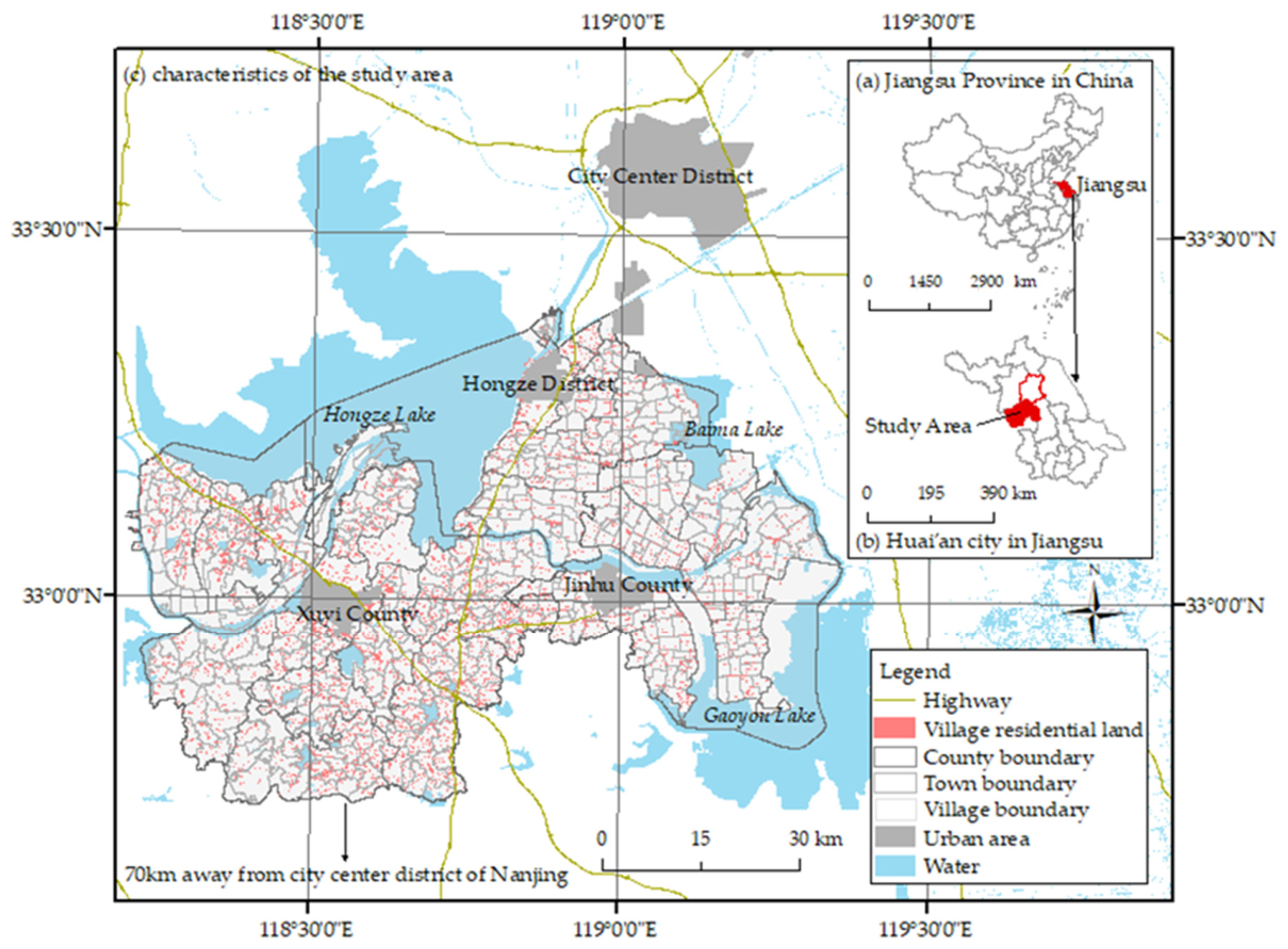
This research focuses on Xuyi County, Jinhu County, and Hongze District in Huai’an city, Jiangsu Province, China (Figure 1). Jiangsu, a highly developed province, has developmental disparities across its regions. Huai’an, in northern Jiangsu, has experienced significant rural population decline, low urbanization rates, and uneven urban–rural development, influenced by Shanghai and Nanjing. By 2023, these counties had a combined registered population of 1.465 million, with a rural outflow rate of 27.11%, leading to a 23.07% housing vacancy rate and 56.63% of rural households purchasing urban housing. The fertile land and extensive water networks in this area make it crucial for grain production in Eastern China, highlighting the importance of addressing rural population loss and food security.
In 2018, Jiangsu’s government introduced policies to improve housing conditions in northern Jiangsu and foster urban-rural integration, categorizing villages to encourage farmers to centralize living spaces and withdraw from homesteads with compensation. This policy background necessitates understanding the dynamics among farmers’ willingness to withdraw from homesteads, the village environment, and urban-rural migration characteristics. This setting provides a foundation for exploring the effects of the village environment and multidestination urban housing purchases on village homestead improvement potential.

3.1.2. Data Sources

The dataset for this study was obtained from a comprehensive survey of rural households conducted by the Huai’an City Bureau of Statistics in 2019, supplemented by detailed fieldwork by the research team in all villages from 2020 to 2022. It includes data on rural households’ willingness to withdraw from homesteads, their current housing situations, family demographics, and population figures at the administrative village level. Additional data were sourced from the “Huai’an Statistical Yearbook 2022” for surface information, and the industrial and fiscal data for villages and towns were extracted from the “Hongze Yearbook 2022,” “Jinhu Yearbook 2022,” and “Xuyi Yearbook 2022.” Information on the government-designated village types came from the “Huai’an Town and Village Layout Planning (2019 Edition).” Moreover, data on commercial outlets in villages were obtained from Tianyancha, while geospatial data at the village scale, including details on water networks and settlement connectivity, were acquired from the National Basic Geographic Information System and refined using the third land survey. Points of interest (POI) data provided information on educational and medical facilities, as well as the locations of township and county government offices, which were manually verified and corrected. After towns with county (district) government offices were excluded, the analysis encompassed 27 towns (districts) and 439 village-scale spatial units. This rich dataset forms the basis for analyzing the spatially varying impacts of village environments and multidestination urban housing purchases on village homestead improvement potential.

3.2. Research Design and Methods

In this study, we examine the determinants of spatial nonlinearity and variations in impact effects [62], utilizing MGWR and K-means clustering as primary methods. Our approach includes the following:
First, we assess the spatial autocorrelation of village homestead improvement potential and urban housing purchases, alongside the spatial significance of village environmental factors, using a global spatial autocorrelation method. The formula involves
Moran s   I = n i = 1 n j = 1 n W ij × i = 1 n j = 1 n W ij   ( y i y - )   ( y j y - ) i = 1 n ( y i y - ) 2
where n is the total number of village units; yi and yj denote the attribute values of the ith village unit and the jth village unit, respectively; Wij is the spatial weight matrix; and y - is the average value of all units. A higher Moran’s I absolute value indicates stronger global spatial autocorrelation.
Another method is local spatial autocorrelation analysis. Hot spot analysis (Getis–Ord Gi*) is used to represent the local agglomeration of village homestead improvement potential and is divided into cold-spot and hot-spot clusters. The formula is as follows:
G i * =   j = 1 n W ij y j   j = 1 n y j n j = 1 n W ij j = 1 n y j 2 n   ( j = 1 n y j n ) 2 n j = 1 n W ij 2   ( j = 1 n W ij ) 2 n     1
The analysis is normalized and expressed as Z(Gi∗), with larger values indicating more pronounced clustering.
Next, we applied stepwise regression to identify significant village environmental variables and used OLS regression to model the relationships between village environmental elements, village homestead improvement potential, and urban housing purchases, including an interaction model to preliminarily evaluate the interplay among these factors.
Two points about interpretation apply to every specification reported below. The stepwise, OLS and MGWR estimates are obtained from a single cross-section of villages, so they describe how village homestead improvement potential covaries with the village environment and with urban housing purchases; they do not identify causal effects, and no attempt is made here to rule out reverse relationships or omitted common causes. The language used in Section 4 and Section 5 has been chosen accordingly.
To address the limitations of OLS models, this study adopts MGWR, which extends the geographically weighted regression (GWR) framework of Fotheringham, Charlton and Brunsdon (1996) [63] by allowing each explanatory variable its own bandwidth so that relationships operating at different spatial scales can be distinguished [64]. MGWR refines estimates by using a spatial weight matrix with an optimal bandwidth, allowing for local data influences, and addressing spatial heterogeneity. This approach is particularly effective for examining the diverse impacts of environmental and urban factors on village development. The MGWR model is formulated as
y i = j = 1 k β b w j u i , v i x i j + ε i
where x i j is the value of variable j for administrative village i, bwj denotes the bandwidth used for the regression coefficient of variable j, β b w j is the regression coefficient of variable j, and u i , v i represents the spatial location of administrative village i. The analysis utilizes MGWR 2.2 software from Arizona State University, employing a golden section search for bandwidth determination and a Bisquare kernel function.
Finally, we employ the K-means algorithm to cluster the regression coefficients derived from the MGWR model. The objective of clustering is to minimize the intracluster distances among samples while simultaneously maximizing the intercluster distances. The within-cluster sum of squared errors, denoted by E, is commonly used as the criterion measure function, and its calculation is as follows [65]:
E = i = 1 k x C i | x μ i | 2
where x represents the value of the sample object and μi is the mean value of cluster Ci, which is calculated as follows:
μ i = 1 | C I | x C i x
It is worth stating explicitly how geography enters this final step, because the K-means algorithm itself does not read coordinates. Spatial information enters earlier and is carried into the clustering through the input data. MGWR estimates a separate coefficient for every explanatory variable at every village by weighting nearby observations more heavily, with the weighting distance chosen separately for each variable. Each village is therefore described by a vector of location-specific coefficients, and two villages have similar vectors when improvement potential responds to the village environment and to urban housing purchases in a similar way in both places. Clustering is performed in this coefficient space. The procedure is thus best described as a spatially informed, or spatially embedded, coefficient-clustering workflow: the distance function used by K-means contains no contiguity or spatial-continuity term, and the procedure should not be described as spatially constrained clustering in the strict sense, but the attributes it partitions have already been produced by a spatially weighted estimator and therefore encode spatial heterogeneity.
What this workflow produces are groups of villages that share a similar mechanism of influence, not necessarily blocks of contiguous territory. That is a deliberate feature rather than a shortcoming: two villages that are not neighbours but whose coefficient profiles are alike can reasonably be addressed with the same policy instrument, whereas two adjacent villages whose profiles differ should not be. When such groupings are used in administrative practice, contiguity and jurisdictional boundaries can be imposed afterwards as an implementation layer without altering the underlying diagnosis. A comparable logic has been applied in peri-urban farmland zoning, where multidimensional evaluation results with pronounced spatial differentiation were clustered at the village scale to derive four management zones and zone-specific recommendations [66]; the parallel we draw is with the practice of clustering spatially differentiated multidimensional attributes and translating the resulting groups into management guidance, not with any claim that either that study or this one imposes a strict adjacency constraint within the clustering algorithm itself.

3.3. Descriptive Statistics and Spatial Characterization of Variables

3.3.1. Variable Selections

Building on previous research, we utilize households’ willingness to withdraw from homesteads as a direct and accurate representation of improvement potential. Furthermore, we adopt China’s smallest administrative unit, the village, as the statistical unit, with village homestead improvement potential (VHIP) defined as the proportion of households within an administrative village willing to withdraw their homesteads. This is shown in Table 1.
Aligned with the established theoretical framework and prioritizing scientific accuracy, comprehensiveness, and data consistency, we devised a village environmental variable index system covering six dimensions: location, natural, economic, residential, social, and policy. Table 1 outlines our selection of locational indicators, including distances to towns (A11Y-Town), county seats (A11Y-County), and urban districts (A11Y-City), alongside a supplementary measure of proximity to external transport points (A11Y-External), such as highway exits and transport hubs. The natural environment is assessed through water network density (Water), terrain (Terrain), ecological reserve proportion (Ecological Reserves), and the presence of NIMBY facilities, reflecting their influence on living standards and safety, which affects village homestead remediation potential. Economic factors are gauged through household income (Revenue) and town fiscal income (GDP), which indicate the village’s economic status. Residential aspects are evaluated through homestead land area (Av-Homestead), housing quality (Q-Housing), and commercial facility availability (Commercial). The social dimensions include household population (Household-Pop), original and current social connectedness (ORIG-Connectedness, CUR-Connectedness), and population density (Pop-Density). Policy considerations focus on development restrictions (Restrictive), township revocation status (Revocation), and policy-supported residential points (Preferential).
For the urban housing purchase variables, we measure the proportion of village households engaging in urban housing purchases (TUHP), which are further categorized into township (THP), county (CHP), and remote (RHP) housing purchases, reflecting the diverse motivations behind these acquisitions.

3.3.2. Descriptive Statistics

Table 2 indicates that among the 231,309 households in 439 villages, about half are willing to give up homestead land. VHIP averages at 54.38%, ranging widely from 0% to 100%, with a median of 56.61% and a CV of 0.63, signifying varied remediation potential—109 villages have VHIP below 20%, and 149 above 80%. Environmental factors show significant variability, such as A11Y-City with a fivefold difference, and CUR-Connectedness varies markedly. Economic and social factors are less variable, while natural and policy factors display higher CVs, pointing to more pronounced differences. Urban housing purchases are significant, with 55.60% of households participating, an average TUHP of 56.61%, and a range from 0.31% to 99.84%. Housing purchases follow a hierarchy, CHP, THP, and RHP, with township purchases having the highest CV at 0.96, indicating varied town attractiveness and development.
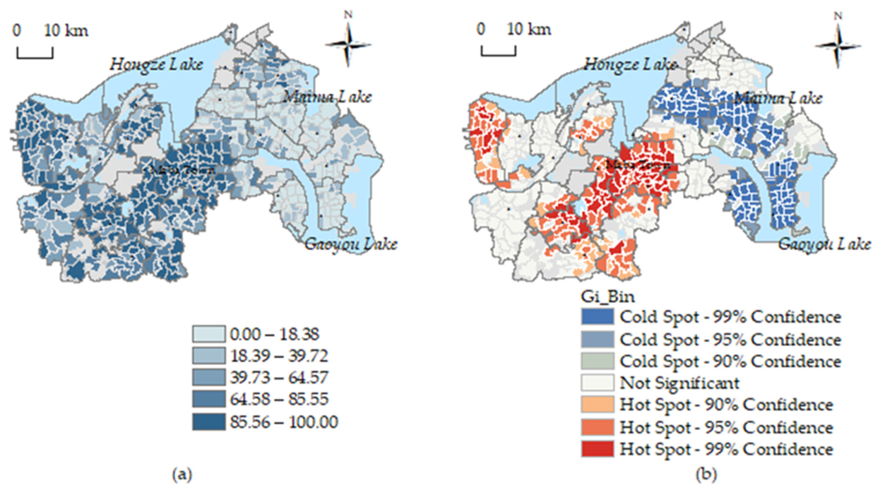
As shown in Table 2, using Moran’s I index in GeoDa 1.22 software, we found positive spatial autocorrelation for all variables except Preferential, with p-values below 0.05, suggesting spatial clustering. Figure 2 shows VHIP spatial pattern with higher values in the south, lower in the north, and high-value hotspots around five towns including Maba Town in Xuyi County’s east and Baoji Town in the west, averaging 87.56% VHIP across 118 villages. Low-value cold spots are mainly in central Hongze District and several towns in Jinhu County, with an average VHIP of 17.02% across 120 villages.

4. Results

4.1. Factors Associated with VHIP

4.1.1. Variable Selection and Models

Our analysis began with backward stepwise regression to sift through variables related to the village environment. Table 3 shows that key variables from each environmental element category are significantly associated with VHIP, consistent with the previously established theoretical framework. The nonsignificant variables include A11Y-External, Ecological Reserves, NIMBY, GDP, Commercial, ORIG-Connectedness, and Pop-Density. The insignificance of some variables may stem from their inadequate representation of the quality of a village environment. For example, ORIG-Connectedness, which measures material social connections within a village, may not reflect true social connectivity in increasingly hollowed-out villages. The lack of significance of other variables could be due to external factors; for instance, the insignificance of A11Y-External might be related to the prevalence of car ownership, reducing the relevance of proximity to transportation points. Similarly, the use of town-level fiscal income data as a proxy for village-level GDP could explain its non-significance. These readings are offered as interpretations to be examined in later work rather than as established explanations of the non-significant estimates.
We advanced our analysis by constructing multiple OLS models with VHIP as the dependent variable. Model 1 included village environmental elements, while Models 2–5 focused on different urban housing purchase types. Models 6–9 explored the interactions between village environmental elements and each housing purchase type. Recognizing the limitations of traditional regression models in capturing spatial autocorrelation, we integrated environmental factors and urban housing purchase variables (TUHP, THP, CHP, RHP) and used the geometric centers of villages (ui, vi) and VHIP (yi) to develop spatially aware models through the GWR and MGWR approaches. Model 10, which employed GWR for validation, and Models 11–14, which used MGWR, aimed to better understand the spatially varying relationships.
As shown in Table 4, the GWR and MGWR models significantly outperformed the OLS model, as indicated by the higher R2, Adj. R2, and log-likelihood values and lower AICc values. MGWR models showed a superior fit and more significant results across villages, suggesting that adjusting modeling assumptions to the same spatial scale enhances fit and analytical outcomes. This highlights the effectiveness of the MGWR model in explaining spatial variations in terms of influences more accurately than the other models do.

4.1.2. Associations Between Village Environmental Elements and VHIP

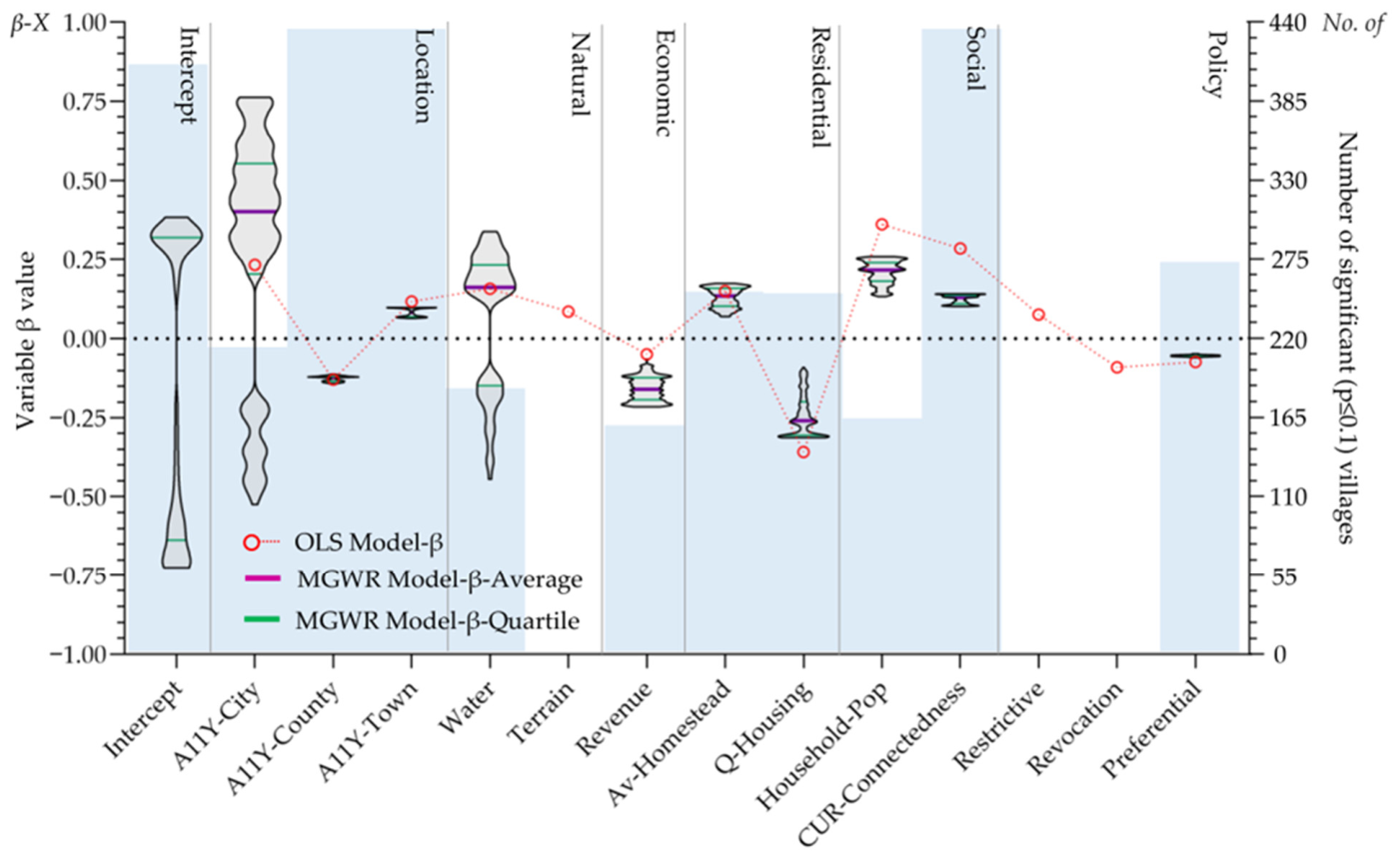
Table 5 presents the results from traditional OLS models (Models 1, 6–9), providing a global view of how various village environmental elements covary with VHIP. Across these models, eight variables—A11Y-City, A11Y-Town, Water, Terrain, Av-Homestead, Household-Pop, CUR-Connectedness, and Restrictive—are consistently positively associated with VHIP, so that higher values of these variables accompany higher village homestead improvement potential. For instance, villages further from urban centers exhibit higher improvement potential. Conversely, five variables—A11Y-County, Revenue, Q-Housing, Revocation, and Preferential—are negatively associated with VHIP. Regarding variable significance stability, Revenue loses significance in Models 7–9, and Terrain in Model 8, while other variables remain consistently significant. In terms of impact strength, the variables rank as follows: Household-Pop, Q-Housing, CUR-Connectedness, A11Y-City, Water, Av-Homestead, A11Y-County, and A11Y-Town, underscoring social, residential, and locational factors as the strongest global correlates of VHIP.
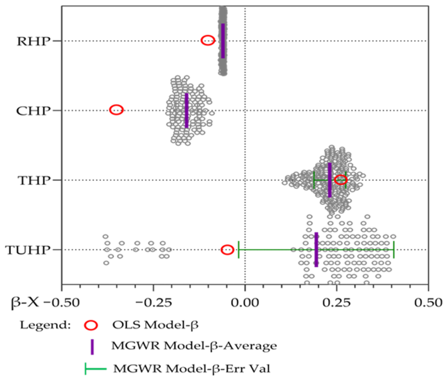
Upon examining spatial variation, we assessed significant village environmental elements (p ≤ 0.1) from Model 11, depicted in Figure 3’s violin plot. Globally, fewer variables are significant; Terrain, Restrictive, and Revocation are not significant in any village, while A11Y-County, A11Y-Town, and CUR-Connectedness are significant in all 439 villages. Spatially, A11Y-City and Water exhibit significant variation with associations of both signs in different locales. In contrast, A11Y-County, A11Y-Town, and Preferential show little spatial variation and uniform directions of association. In terms of magnitude, the associations of A11Y-City, Water, Q-Housing, Household-Pop, Av-Homestead, CUR-Connectedness, and Revenue diminish sequentially. The MGWR model’s global insights corroborate our theoretical framework, emphasizing the significant spatial variability in the associations between locational, natural, economic, residential, social, and policy factors and VHIP. Integrating OLS and MGWR results, we pinpoint locational and natural elements, particularly water, as well as residential and social factors, as pivotal in explaining VHIP variations.

4.1.3. Associations Between Urban Housing Purchases and VHIP

Table 5 reveals that the relationship between TUHP and VHIP in OLS models (Models 2 and 6) is insignificant and inconsistent, suggesting no straightforward link between farmers’ urban housing purchases and their willingness to improve homesteads, a result consistent with H1. Subsequent models (3–5 and 7–9) clarify that the destination of purchase matters: THP is positively associated with VHIP, as proximity to original homesteads may encourage farmers to exit for financial gains without disrupting their external environment. In contrast, CHP and RHP are negatively associated with VHIP, reflecting the value placed on ancestral homes and rural land, which may deter farmers from leaving when buying distant properties. CHP shows the strongest association, followed by THP, with RHP being the weakest, underscoring the ancestral home’s significance for county dwellers.
Spatial analysis of TUHP, THP, CHP, and RHP in Models 11–14, visualized in Figure 4, shows TUHP’s significant, spatially diverse associations with VHIP in certain villages, supporting H2. While the direction of the associations is consistent, their intensity varies, with town purchases showing stronger associations than county or remote ones. RHP displays minimal spatial variation, resonating with migrants’ reluctance to abandon homesteads after acquiring homes in larger cities. THP demonstrates the greatest spatial variability, indicative of the varied development across townships in the study area.

4.2. Spatial Variation in the Estimated Associations

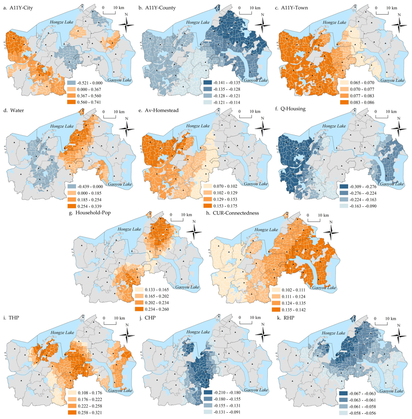
To explore the spatial heterogeneity of the estimated associations, we employed MGWR 2.2 software to analyze the MGWR models and visualize the local regression coefficients for the 11 retained variables. Model 11 includes village environmental factors, while Models 12 to 14 focus on THP, CHP, and RHP. We stratified the direction of association and graded the magnitudes using a natural break point method, and the results are presented in Figure 5.
The local estimates reveal distinct spatial regimes in the association between locational factors and VHIP. A11Y-City is positively associated with VHIP in county hinterlands but negatively associated in peripheral zones. The A11Y-County association weakens from north to south, suggesting higher VHIP in villages nearer to urban centers and further from county seats. This indicates a non-uniform appeal of less developed urban areas to farmers, with a limited influence around county towns. In Xuyi County, A11Y-Town shows a positive but weaker association with VHIP compared to more urbanized areas.
Natural elements like water network density form valuable clusters east of Hongze Lake and less valuable ones near Xuyi county. On plains, dense networks accompany poorer living conditions and higher VHIP, consistent with residents seeking to leave. In contrast, hilly regions with tourism potential due to their scenic beauty show lower VHIP, consistent with “courtyard economy” income raising the value of retaining the homestead. Residential environmental elements show associations that weaken from village outskirts to centers. VHIP is higher where homestead plots are larger and where housing quality is poorer, notably in northwest Xuyi County, where strict housing reconstruction policies since 2008 have forced farmers to consider relocation for better living conditions. Southeastern Jinhu County, with its developed rural tourism, provides a superior living environment, making farmers less likely to leave. Social elements indicate that larger families near major roads like the Ninglian National Highway are more apt to withdraw from homesteads, with a younger, more mobile population favoring urban life. This trend reflects a hesitancy to leave rural homes as family sizes decrease and mobility grows. CUR-Connectedness (the share of vacant farmhouses) is positively associated with VHIP, with a slight east-to-west gradient. As discussed in Section 2.1 and Section 5.4, vacancy and willingness are plausibly co-determined, so no directional reading is attached to this association.
The association between urban housing purchases and VHIP varies spatially, starting with THP, which diminishes from the outskirts towards the center across all counties. In peripheral areas like Maba Town in Xuyi County, and Tugou and Tajie Towns in Jinhu County, strong local industries and services enable farmers buying town homes to improve their living conditions while staying connected to their communities. Conversely, the negative CHP association is strongest around Maba Town, weakening towards the east and west, indicating a preference among these homeowners to retain their rural land and identity. RHP shows the weakest association with VHIP, with a slight decline from west to east in Hongze District and Jinhu County, highlighting diverse reasons and timings for out-of-county home purchases. Some recent buyers aim to keep their rural ties, whereas others, having moved away longer, sever connections with their rural origins.

4.3. VHIP Impact Zone Delineation

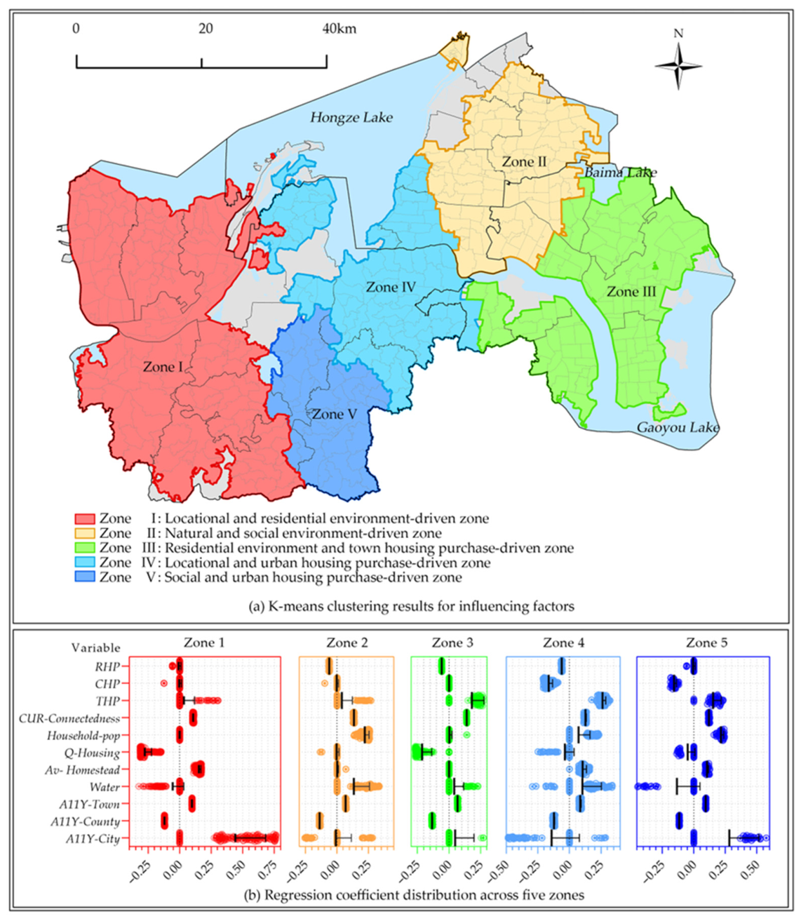
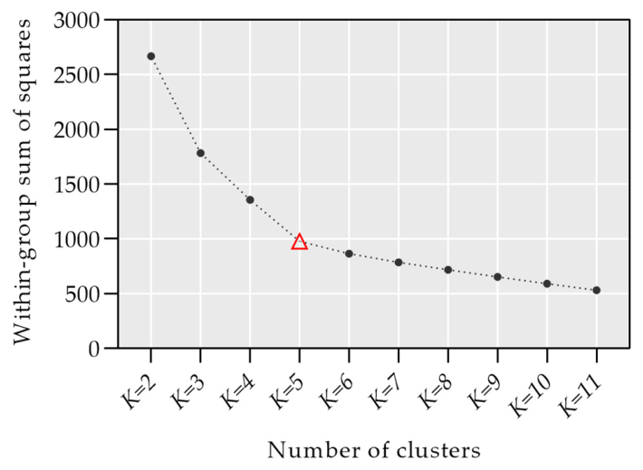
To develop region-specific policy recommendations, we applied K-means clustering to the regression coefficients of the MGWR model, focusing on 11 key factors. We explored 10 cluster models with K values from 2 to 11, identifying K = 5 as optimal based on the “turning point” in the within-group sum of squares, as illustrated in Figure 6.
Because this step is central to the contribution of the study, its logic is worth restating at the point of use. The quantities being clustered are not the raw village attributes but the local regression coefficients produced by the MGWR model, one coefficient per retained variable per village. A village is thus represented by the profile of relationships that hold in that particular place, and villages are grouped according to the similarity of those profiles. Geography enters through the estimator rather than through the clustering: K-means partitions the coefficient space without reference to coordinates or adjacency, so the procedure is spatially informed rather than spatially constrained. Once the labels are mapped back onto the villages, the resulting zones can be read as areas within which improvement potential responds to the village environment and to urban housing purchases in broadly the same way, and each zone can therefore be addressed with a coherent set of instruments. The zones are groupings by mechanism, and it is not a requirement of the method that they form unbroken territorial blocks; where an administrative unit spans more than one zone, contiguity can be imposed at the implementation stage.
Figure 7a,b illustrates the spatial distribution and clustering of variables affecting VHIP across different zones. Zone I, covering 30.52% of the study area in Xuyi County’s hilly regions, shows high VHIP, primarily influenced by locational and residential elements with minimal urban housing impact. Zone II, making up 21.18% of the area in Hongze District’s water-rich plains, has lower VHIP, driven by natural and social elements, including Water and CUR-Connectedness. Zone III, near Baima and Gaoyou Lakes in Jinhu County, benefits from rural tourism, with VHIP shaped by residential environment elements and THP. Zone IV, at the Hongze District and Xuyi County boundary, exhibits higher VHIP, with locational elements and urban housing purchases as key influences, notably marked by the negative impact of A11Y-City. The smallest zone, located in Huanghuatang Town, has the highest VHIP at 84.53%, influenced significantly by social factors and urban housing purchases, like Zone II. Each zone displays unique patterns of influence, highlighting the diverse drivers of VHIP across the study area.

5. Discussion and Conclusions

5.1. Spatial Heterogeneity of VHIP: Geographical Perspective

This study leverages a comprehensive full-sample survey of rural households, providing a precise spatial characterization of VHIP and essential data for examining spatial heterogeneity from a geographical perspective. We found notable spatial disparities in VHIP with significant spatial autocorrelation, which challenges the linear assumption of decreasing homestead remediation potential from remote to suburban areas based on urban-rural proximity [22,48]. Our findings suggest instead that spatial heterogeneity is associated with a more complex set of village characteristics.
We employed our theoretical framework, and the OLS model showed a moderate fit with an R-squared of 0.5, which improved to 0.775 (adjusted R-squared 0.738) in the MGWR model when spatial elements were included, highlighting the critical role of spatial factors in understanding VHIP. Locational factors are the strongest correlates, but the direction and strength of their association vary across urban tiers, with villages farther from urban centers more likely to exit homesteads, unlike those near county towns where the association is reversed, and proximity to townships showing a positive association.
We also examined how five other categories of village environmental elements covary with VHIP. Factors such as village water network density, homestead land area, housing quality, average household population, and social connectedness are all significantly associated with it. Some of these leading factors also exhibit spatial heterogeneity. For instance, water network density presents a dichotomous spatial layout; in areas with rapidly developing rural tourism, lower density accompanies lower VHIP, consistent with tourism enhancing living environments and job opportunities, becoming key to retaining residents [46]. In other regions, high water-network density accompanies poorer living conditions and higher VHIP. Some variables show less spatial heterogeneity, with effects consistent with previous research, such as larger homestead land areas in suburban regions correlating with higher exit intentions [20] and greater disruption of existing social networks accompanying higher VHIP [48,67].
Economic and policy environmental factors show little association with VHIP, diverging from previous findings [11,12,35]. This may be partly due to the study area’s location in the economically advanced Yangtze River Delta region of China, where villages have higher economic development levels and rural households generally enjoy higher incomes from working in large cities. Additionally, the lag in policy feedback may play a role. The insignificance of these factors also indirectly reflects a shift in rural Chinese society from material to spiritual needs, especially in the economically developed eastern regions.

5.2. Differences in the Impact of Multidestination Urban Housing Purchases

Farm households with minimal reliance on rural life and ownership of urban housing are often viewed by the government as prime candidates for homestead withdrawal, yet the reality of this effect is highly variable [68]. Our analysis differentiates the residence and wealth effects of urban housing purchases by assessing their associations with village homestead improvement potential. We find that township home purchases, which we read primarily through the residence effect, are positively associated with homestead improvement potential. In contrast, county home purchases, influenced by both residence and wealth effects, and out-of-county purchases, which are less common, are generally negatively associated with it, though with notable variability.
The strength of the township-purchase association varies markedly with village environments across regions. MGWR analysis provides detailed insights into these residence and wealth effects, especially in townships with good living conditions and job opportunities, where township home purchases show associations that differ from those of county home purchases.
One reading of this pattern, and the one advanced in the submitted version, is that the attachment of wealthier farmers to their homesteads, and the non-material needs those homesteads satisfy, work against improvement efforts [31]. A second and, in our view, equally compelling reading was noted during review, and our own field observations in the study area are consistent with it, although we have not tested it and do not present it as a quantified result. Rural households in the study area are markedly differentiated, and the destination of an urban housing purchase is closely bound up with that differentiation. Relatively affluent amphibious households, which can sustain a life spanning the county town and the village, are the households most able to buy in the county town; for them the homestead is retained as a marker of status, as a safety net and as a potential asset, and compensated withdrawal is comparatively unattractive. Households that buy within the township are more often liquidity-constrained, and for them the compensation obtainable through withdrawal may be one of the few means of meeting the costs of moving. Read in this way, the divergence between township and county-town purchases reflects differences in asset capacity and in the constraints on migration, not only differences in the residential and investment attributes of the destinations. We therefore present the residence and investment reading and the class-differentiation reading as complementary rather than attributing the pattern to either alone. Our findings nevertheless have practical implications for local governments under both readings. Maba township in Xuyi County, for example, with its strong public services and industrial base providing job opportunities, exhibits a residential effect that encourages farmers to buy homes within the township, and its homestead improvement potential is correspondingly higher. Strengthening townships with favourable conditions and developing a dual-core township system (county towns—key towns) appears a promising direction for leveraging centralized agglomeration effects [53], reducing population loss, and promoting in situ urbanization and rural revitalization; we frame this as a direction suggested by the associations rather than as an effect this design can demonstrate.
One caution must accompany this interpretation. The unit of analysis throughout this study is the administrative village, whereas class position, purchase financing and the intended use of a homestead are attributes of individual households. Inferring household-level mechanisms from village-level aggregates risks the ecological fallacy, and the estimates reported here cannot establish which households within a village were bought where or why. Distinguishing the differentiation account from the residence and investment account would require household-level data on income, occupation, asset holdings, the financing of the urban purchase, and the subsequent use of the homestead. Collecting such data is the most direct extension of the present work.

5.3. Zoning-Based Policy Implications for Socially Sustainable Development

The analysis reveals spatial heterogeneity in the impacts of village environmental elements and urban housing purchases for different purposes. Using K-means clustering on MGWR model coefficients, we discerned distinct impact differences across zones. Villages were categorized into five areas based on dominant factors: locational and residential, natural and social, residential and township housing purchase, locational and urban housing purchase, and social and urban housing purchase-driven areas. This provides a foundation for local governments to formulate policies that enable diversified management to achieve sustainable social development in rural areas.
It is worth being precise about what this zoning is and is not. The features on which villages are grouped are the local regression coefficients estimated by MGWR, so each village is represented by the profile of relationships that holds in that place; villages therefore fall together when improvement potential responds to the village environment and to urban housing purchases in a similar manner, not when they happen to lie close to one another. Spatial information is embedded in the features rather than imposed by the clustering algorithm, and the zones are consequently groupings by mechanism. For policy purposes this is the property that matters, since it is the mechanism, and not the location as such, that determines which instrument is appropriate; where an administrative unit spans more than one zone, contiguity and jurisdictional boundaries can be applied as a further implementation layer.
A second clarification concerns the epistemic status of the suggestions that follow. As stated in Section 3.2 and Section 5.4, every estimate in this study is a cross-sectional association: causal effects are not identified, at least one relationship (vacancy and willingness) is plausibly bidirectional, and household-level mechanisms cannot be recovered from village-level aggregates without risking the ecological fallacy. The zone-specific suggestions below are therefore not demonstrated remedies. They are hypotheses about which policy instruments are most likely to fit the mechanism profile of each zone, and any directive phrasing that remains should be read conditionally, as indicating the direction an intervention could take if the observed associations reflect underlying mechanisms.
Regarding Zone I, which has a peripheral mountainous location and high willingness to withdraw from homesteads, the coefficient profile identifies the residential environment as the dominant correlate of improvement potential. Candidate instruments, whose effects remain to be tested, include compensated homestead withdrawal, resettlement near well-serviced townships, and land consolidation oriented toward rural tourism tied to local agriculture and scenery. Infrastructure improvements and “courtyard economy” initiatives may help raise rural living standards and farmer incomes [20]. Any such measures would need to remain consistent with the principle that “lucid waters and lush mountains are invaluable assets,” so that ecological preservation is not compromised.
Zone II, which is located in Hongze District and has flat terrain and dense water networks, has a low VHIP, which is primarily influenced by natural and social factors. Field research indicates that many households have bought homes in county towns, maintaining a dual urban-rural lifestyle with homesteads symbolizing spiritual ties. To respect farmers’ preferences, a case can be made for moderating the pace of homestead remediation while affirming rural land rights, enforcing a “one household, one homestead” policy, and freeing up idle homestead land [40]. Enhancing compensation for homestead exits and ensuring policy consistency may help farmers value their land realistically. Linking housing security with homestead exits through low-rent and public rental housing could ease farmers’ urban transition and safeguard their housing rights; whether it would in fact strengthen the residential effect of urban housing on withdrawal is a question for evaluation rather than a result established here [69].
Zone III, which is located at the junction of two lakes, is a key rural tourism spot in the Yangtze River Delta with a low VHIP. High rates of home purchases in county towns coexist with a thriving rural tourism industry, allowing farmers to reside in towns while capitalizing on their homestead land for tourism. This “self-sufficiency” reduces the urgency of comprehensive homestead remediation. Local governments could support these development paths by improving urban-rural connectivity, regulating the rural tourism market to foster a unified tourism brand, and encouraging inclusive participation for shared prosperity. Attention to rural gentrification remains warranted, as urban investments in rural homesteads for tourism, though initially beneficial, risk displacing residents if unchecked [70].
Zone IV, which is located at the nexus of Hongze District and Xuyi County and encompassing towns such as Maba and Jiangba, has cultivated unique industrial clusters through the growth of small and microenterprises. This development allows farmers to pursue nonagricultural jobs via township housing purchases, decreasing land reliance. The coefficient profile of this zone is consistent with advancing village homestead remediation and reallocating exited land to support township industries; we put this forward as a direction for piloting rather than as a demonstrated remedy. Improving township public services to create subcenters within the county may facilitate high-quality in situ urbanization for farmers [27,53].
Zone V, which is situated on the southern outskirts near Nanjing with well-developed transport links, has faced significant rural depopulation, exacerbated by Nanjing’s farmland acquisition for a university town in 2019, which fragmented social networks and resulted in the highest VHIP. The associations observed here point to homestead and farmland remediation as a plausible direction, one that would capitalize on proximity to Nanjing and transport access to shift agriculture toward intensive, modern methods and the supply of fresh produce to nearby cities [66]. Building concentrated residential areas adjacent to the university town and townships could help farmers who prefer to stay near their villages gain access to urban amenities, supporting rural revitalization.
Because all of the above rests on associational evidence, two implementation principles apply across zones. First, zone-specific instruments are best introduced through small-scale pilots with pre-specified monitoring indicators—for example, uptake of compensated withdrawal, post-relocation livelihood and housing outcomes, and the reuse efficiency of exited land—so that the causal questions set out in Section 5.4 are answered in the course of implementation rather than assumed at the outset. Second, the zone assignments themselves are provisional diagnoses to be revisited as new data accumulate, not fixed administrative labels.

5.4. Contributions to Research, Limitations, and Future Work

This study contributes to research on the rural human–land relationship in three respects. Substantively, it examines village homestead improvement potential jointly against the elements of the village environment and against urban housing purchases disaggregated by destination, rather than treating urbanization as a single undifferentiated condition, and it shows that the associations involved vary systematically across space. Methodologically, it links a multiscale local estimator to a clustering step in a single analytical chain: because MGWR yields a location-specific coefficient for every variable at every village, the resulting coefficient vectors can be used as the feature space in which villages are grouped, so that the grouping is driven by similarity of mechanism rather than by similarity of raw attributes. Practically, and this is where we locate the principal contribution, it converts estimated spatial heterogeneity into an operational instrument: the five zones are read through their dominant coefficients and translated into differentiated policy directions, offered as hypotheses for policy experimentation, which gives local governments an alternative to uniform improvement targets. The institutional and strategic tools derived from these findings provide a basis for local policy decisions, promote sustainable rural development, and offer insights for land system reforms in China and other developing nations.
Nonetheless, our research has limitations, and they bound the claims made above. The most important concerns causal inference. The analysis rests on a single cross-section, so the OLS and MGWR estimates describe covariation and cannot identify causal effects. For the same reason, the zone-specific suggestions in Section 5.3 are framed as directions for piloting and evaluation, not as interventions whose effects have been demonstrated. This qualification bears with particular force on the vacancy of farmhouses. A reviewer rightly observed that a village where households are more willing to urbanize will, over time, come to have more vacant dwellings, so that vacancy and willingness are jointly determined; the cross-sectional models estimated here cannot disentangle that feedback, and the associated coefficient should not be read as the effect of vacancy on willingness. We have retained the variable, because vacancy remains an informative descriptor of village conditions and its removal would not resolve the underlying simultaneity, but we have adjusted the language throughout the manuscript so that no causal claim is attached to it. A second limitation concerns the level of inference. The unit of analysis is the administrative village, so the household-level mechanisms discussed in Section 5.2, including class differentiation, cannot be identified from these data without risking the ecological fallacy. A third limitation concerns the zoning procedure. Villages are grouped in the space of MGWR coefficients, and while those coefficients are produced by a spatially weighted estimator, the clustering algorithm itself imposes no contiguity constraint; we did not compare the resulting partition with one produced by a spatially constrained regionalisation method, and we thank the reviewer for drawing attention to this. A fourth limitation is that the study is region specific, focusing on China’s economically advanced eastern areas, and may not reflect conditions in regions with differing economic, natural, and social contexts. Fifth, the environmental variables that were used were limited by the survey scope and may not fully capture the village environment, possibly skewing the results. Sixth, the dependent variable records a stated willingness rather than an observed withdrawal, so it should be read as latent, policy-relevant potential. Finally, the policy suggestions stem from our team’s analysis without full integration with local policies, which could introduce discrepancies.
These limitations indicate the direction of future work. Identifying the relationship between vacancy and withdrawal willingness requires designs that the present data cannot support: repeated observation of the same villages, so that changes in willingness can be related to prior changes in vacancy; time-lagged specifications; instrumental-variable or quasi-experimental strategies that exploit policy-induced variation; or structural models that represent the two as jointly determined. Distinguishing class differentiation from the residence and investment mechanisms requires household-level data on income, occupation, assets, the financing of urban purchases and the subsequent use of the homestead. Assessing the robustness of the zoning requires the comparison suggested by the reviewer, in which the same coefficient vectors are partitioned by a spatially constrained regionalisation algorithm and the two partitions are compared, together with alternative criteria for the number of groups. None of these analyses have been carried out here, and we set them out as the agenda that follows from this study rather than as results it contains. Extending the analysis to regions with different economic, natural and institutional conditions, and involving local policymakers in the design of both the survey instrument and the zoning criteria, would further strengthen the external validity and the practical relevance of this line of work.

Author Contributions

Conceptualization, C.-X.W., C.C. and S.-Z.W.; methodology, C.-X.W. and C.C.; software, C.C.; validation, C.-X.W., C.C. and S.-Z.W.; formal analysis, C.-X.W. and C.C.; investigation, C.-X.W. and C.C.; resources, C.-X.W. and W.-L.H.; data curation, C.-X.W. and C.C.; writing—original draft preparation, C.-X.W. and C.C.; writing—review and editing, S.-Z.W. and W.-L.H.; visualization, C.-X.W. and C.C.; supervision, S.-Z.W. and W.-L.H.; project administration, S.-Z.W. and W.-L.H.; funding acquisition, S.-Z.W. and W.-L.H. Equal contribution: Chengxiang Wang and Chi Chen contributed equally to this work. All authors have read and agreed to the published version of the manuscript.

Funding

This research was funded by the National Natural Science Foundation of China, grant number 52078237, and the Foshan Federation of Social Sciences, grant number 2026-GJ234.

Institutional Review Board Statement

The study was conducted in accordance with the Declaration of Helsinki and reviewed by the Academic Ethics Committee of Huaiyin Normal University, which determined that this anonymous, minimal-risk questionnaire survey does not involve ethical issues (Review No. ZL2026001; date: 20 August 2026).

Informed Consent Statement

No separate written consent form was used in this household survey. Verbal informed consent was obtained from all participants before the questionnaire was administered.

Data Availability Statement

The data presented in this study are not publicly available due to privacy and ethical restrictions related to household survey data. Anonymized or aggregated data may be available from the corresponding author upon reasonable request and subject to approval by the relevant institution.

Acknowledgments

The authors thank all respondents who participated in the household survey and SNAS for English language editing support. We also thank the two anonymous reviewers, one of whom suggested the class-differentiation reading developed in Section 5.2 and the spatially constrained clustering comparison now specified as future work.

Conflicts of Interest

The authors declare no conflicts of interest. The funders had no role in the design of the study; in the collection, analyses, or interpretation of data; in the writing of the manuscript; or in the decision to publish the results.

References

  1. Li, J.; Lo, K.; Zhang, P.; Guo, M. Reclaiming small to fill large: A novel approach to rural residential land consolidation in China. Land Use Policy 2021, 109, 105706. [Google Scholar] [CrossRef] [Scilit]
  2. Peng, X. China’s demographic history and future challenges. Science 2011, 333, 581–587. [Google Scholar] [CrossRef] [Scilit] [PubMed]
  3. Yan, J.; Wang, B.; Zheng, W. Homeland attachment, urban integration and rural-urban migrants’ willingness to withdraw rural residential land: A survey in Xiamen, Fujian Province. China Land Sci. 2022, 36, 20–29. [Google Scholar] [CrossRef]
  4. Gao, J.; Song, G.; Liu, S. Factors influencing farmers’ willingness and behavior choices to withdraw from rural homesteads in China. Growth Change 2022, 53, 112–131. [Google Scholar] [CrossRef] [Scilit]
  5. Kong, X.; Liu, Y.; Jiang, P.; Tian, Y.; Zou, Y. A novel framework for rural homestead land transfer under collective ownership in China. Land Use Policy 2018, 78, 138–146. [Google Scholar] [CrossRef] [Scilit]
  6. Li, H.; Zhang, X.; Li, H. Has farmer welfare improved after rural residential land circulation? J. Rural Stud. 2022, 93, 479–486. [Google Scholar] [CrossRef] [Scilit]
  7. Liu, Y.; Wang, A.; Hou, J.; Chen, X.; Xia, J. Comprehensive evaluation of rural courtyard utilization efficiency: A case study in Shandong Province, Eastern China. J. Mt. Sci. 2020, 17, 2280–2295. [Google Scholar] [CrossRef] [Scilit]
  8. Fan, W.; Zhang, L. Does cognition matter? Applying the push-pull-mooring model to Chinese farmers’ willingness to withdraw from rural homesteads. Pap. Reg. Sci. 2019, 98, 2355–2370. [Google Scholar] [CrossRef] [Scilit]
  9. Jiao, M.; Xu, H. How do Collective Operating Construction Land (COCL) Transactions affect rural residents’ property income? Evidence from rural Deqing County, China. Land Use Policy 2022, 113, 105897. [Google Scholar] [CrossRef] [Scilit]
  10. Zhou, T.; Jiang, G.; Ma, W.; Zhang, R.; Yang, Y.; Tian, Y.; Zhao, Q. Revitalization of idle rural residential land: Coordinating the potential supply for land consolidation with the demand for rural revitalization. Habitat. Int. 2023, 138, 102867. [Google Scholar] [CrossRef] [Scilit]
  11. Gao, J.; Cai, Y.; Wen, Q.; Liu, Y.; Chen, J. Future matters: Unpacking villagers’ willingness to withdraw from rural homesteads in China. Appl. Geogr. 2023, 158, 103049. [Google Scholar] [CrossRef] [Scilit]
  12. Huang, X.; Li, H.; Zhang, X.; Zhang, X. Land use policy as an instrument of rural resilience—The case of land withdrawal mechanism for rural homesteads in China. Ecol. Indic. 2018, 87, 47–55. [Google Scholar] [CrossRef] [Scilit]
  13. Wei, H.; Li, L.; Nian, M. China’s urbanization strategy and policy during the 14th five-year plan period. Chin. J. Urban Environ. Stud. 2021, 9, 2150002. [Google Scholar] [CrossRef] [Scilit]
  14. Liu, Y. The basic theory and methodology of rural revitalization planning in China. Acta Geogr. Sin. 2020, 75, 1120–1133. [Google Scholar]
  15. Petrescu-Mag, R.M.; Petrescu, D.C.; Azadi, H. From scythe to smartphone: Rural transformation in Romania evidenced by the perception of rural land and population. Land Use Policy 2022, 113, 105851. [Google Scholar] [CrossRef] [Scilit]
  16. Wang, Z.; Liang, F.; Lin, S.H. Can socially sustainable development be achieved through homestead withdrawal? A hybrid multiple-attributes decision analysis. Humanit. Soc. Sci. Commun. 2023, 10, 574. [Google Scholar] [CrossRef] [Scilit]
  17. Han, S.; Guo, G.; Zhang, C. Impact of endowments and risk coping capacity on the willingness of homestead withdrawal: Based on a survey of 6754 farming households in Jiangsu Province. Resour. Sci. 2024, 46, 218–231. [Google Scholar] [CrossRef] [Scilit]
  18. Liu, R.; Jiang, J.; Yu, C.; Rodenbiker, J.; Jiang, Y. The endowment effect accompanying villagers’ withdrawal from rural homesteads: Field evidence from Chengdu, China. Land Use Policy 2021, 101, 105107. [Google Scholar] [CrossRef] [Scilit]
  19. Wang, J.; Zhao, K.; Cui, Y.; Cao, H. Formal and informal institutions in farmers’ withdrawal from rural homesteads in China: Heterogeneity analysis based on the village location. Land 2022, 11, 1844. [Google Scholar] [CrossRef] [Scilit]
  20. Liu, R.; Yu, C.; Jiang, J.; Huang, Z.; Jiang, Y. Farmer differentiation, generational differences and farmers’ behaviors to withdraw from rural homesteads: Evidence from Chengdu, China. Habitat. Int. 2020, 103, 102231. [Google Scholar] [CrossRef] [Scilit]
  21. Shan, Z.; Feng, C. The redundancy of residential land in rural China: The evolution process, current status and policy implications. Land Use Policy 2018, 74, 179–186. [Google Scholar] [CrossRef] [Scilit]
  22. Rong, L.; Chen, M.; Zhang, T.; Huang, C. Farmers’ willingness to withdraw the over-occupied rural residential land in different locational villages: An empirical analysis of 131 villages, 21 counties in Jiangxi Province. China Land Sci. 2023, 37, 71–79. [Google Scholar]
  23. Yuan, S.; Zhang, X.; Li, S.; Zhu, C.; Shentu, C. Measurement and spatial differentiation of rural residential land value based on region and village location: A case of typical counties and cities in Zhejiang Province. China Land Sci. 2021, 35, 31–40. [Google Scholar] [CrossRef]
  24. Kong, X.; Chen, J.; Liu, D.; Zhao, X. Spatial differentiation and hierarchical collaborative zoning of rural homestead withdrawal potential: A case study of Yicheng City, Hubei Province. Resour. Sci. 2021, 43, 1322–1334. [Google Scholar] [CrossRef] [Scilit]
  25. Xia, M.; Lin, S.; Guo, G. Influential factors of farmers’ willingness in rural residential land quittance in different economic developed areas in Jiangsu Province. Resour. Sci. 2016, 38, 728–737. [Google Scholar] [CrossRef] [Scilit]
  26. Pedersen, H.D.; Therkelsen, A. Being a part of and apart from. Return migrants’ ambivalent attachment to rural place. J. Rural Stud. 2022, 94, 91–98. [Google Scholar] [CrossRef] [Scilit]
  27. Wang, C.; Pang, Z.; Choi, C.G. Township, county town, metropolitan area, or foreign cities? Evidence from house purchases by rural households in China. Land 2023, 12, 1038. [Google Scholar] [CrossRef] [Scilit]
  28. Wang, Y.; Gao, G.; Ning, X.; Li, Y.; Niu, N.; Guo, Y. Willingness of returning migrant workers to purchase houses: A case study of 45 villages in Henan Province, China. Reg. Sustain. 2022, 3, 133–145. [Google Scholar] [CrossRef] [Scilit]
  29. Zou, J.; Chen, J.; Chen, Y. Hometown landholdings and rural migrants’ integration intention: The case of urban China. Land Use Policy 2022, 121, 106307. [Google Scholar] [CrossRef] [Scilit]
  30. Su, K.; Wu, J.; Zhou, L.; Chen, H.; Yang, Q. The functional evolution and dynamic mechanism of rural homesteads under the background of socioeconomic transition: An empirical study on macro- and microscales in China. Land 2022, 11, 1143. [Google Scholar] [CrossRef] [Scilit]
  31. Yang, H.; Yuan, K.; Zhu, Q.; Chen, Y. Effect of farmer differentiation and urban housing on the farmers’ willingness of rural residential land paid-exit. Resour. Environ. Yangtze Basin 2021, 30, 44–53. [Google Scholar]
  32. Yuan, Z.; Fu, C.; Kong, S.; Du, J.; Li, W. Citizenship ability, homestead utility, and rural homestead transfer of “amphibious” farmers. Sustainability 2022, 14, 2067. [Google Scholar] [CrossRef] [Scilit]
  33. Luo, H.; Zhao, X.; Wang, J.; Cai, B.; Pan, Y. A potential estimation and geospatial simulation model for the rural construction land consolidation: A case study of Yicheng County, Hubei Province. China Land Sci. 2021, 36, 118–126. [Google Scholar]
  34. Long, H.; Zhang, Y.; Tu, S. Rural vitalization in China: A perspective of land consolidation. J. Geogr. Sci. 2019, 29, 517–530. [Google Scholar] [CrossRef] [Scilit]
  35. Shi, R.; Hou, L.; Jia, B.; Jin, Y.; Zheng, W.; Wang, X.; Hou, X. Effect of policy cognition on the intention of villagers’ withdrawal from rural homesteads. Land 2022, 11, 1356. [Google Scholar] [CrossRef] [Scilit]
  36. Cheng, L.; Liu, Y.; Brown, G.; Searle, G. Factors affecting farmers’ satisfaction with contemporary China’s land allocation policy—The Link Policy: Based on the empirical research of Ezhou. Habitat. Int. 2018, 75, 38–49. [Google Scholar] [CrossRef] [Scilit]
  37. Wang, C.; Wang, L.; Jiang, F.; Lu, Z. Differentiation of rural households’ consciousness in land use activities: A case from Bailin Village, Shapingba District of Chongqing Municipality, China. Chin. Geogr. Sci. 2015, 25, 124–136. [Google Scholar] [CrossRef] [Scilit]
  38. Gao, J.; Song, G.; Sun, X. Does labor migration affect rural land transfer? Evidence from China. Land Use Policy 2020, 99, 105096. [Google Scholar] [CrossRef] [Scilit]
  39. Gao, J.; Wu, Z.; Chen, J.; Chen, W. Beyond the bid-rent: Two tales of land use transition in contemporary China. Growth Change 2020, 51, 1336–1356. [Google Scholar] [CrossRef] [Scilit]
  40. Wang, Y.; Chen, L.; Long, K. Farmers’ identity, property rights cognition and perception of rural residential land distributive justice in China: Findings from Nanjing, Jiangsu Province. Habitat. Int. 2018, 79, 99–108. [Google Scholar] [CrossRef] [Scilit]
  41. Gao, J.; Yang, J.; Chen, C.; Chen, W. From “forsaken site” to “model village”: Unraveling the multi-scalar process of rural revitalization in China. Habitat. Int. 2023, 133, 102766. [Google Scholar] [CrossRef] [Scilit]
  42. Gao, X.; Xu, A.; Liu, L.; Deng, O.; Zeng, M.; Ling, J.; Wei, Y. Understanding rural housing abandonment in China’s rapid urbanization. Habitat. Int. 2017, 67, 13–21. [Google Scholar] [CrossRef] [Scilit]
  43. Tang, P.; Chen, J.; Gao, J.; Li, M.; Wang, J. What role(s) do village committees play in the withdrawal from rural homesteads? Evidence from Sichuan Province in Western China. Land 2020, 9, 477. [Google Scholar] [CrossRef] [Scilit]
  44. Chen, H.; Zhao, L.; Zhao, Z. Influencing factors of farmers’ willingness to withdraw from rural homesteads: A survey in zhejiang, China. Land Use Policy 2017, 68, 524–530. [Google Scholar] [CrossRef] [Scilit]
  45. Tong, Y.; Niu, H.; Fan, L. Willingness of farmers to transform vacant rural residential land into cultivated land in a major grain-producing area of central China. Sustainability 2016, 8, 1192. [Google Scholar] [CrossRef] [Scilit]
  46. Chen, Y.; Ni, X.; Liang, Y. The influence of external environment factors on farmers’ willingness to withdraw from rural homesteads: Evidence from Wuhan and Suizhou city in central China. Land 2022, 11, 1602. [Google Scholar] [CrossRef] [Scilit]
  47. Gu, H.; Ling, Y.; Shen, T.; Yang, L. How does rural homestead influence the hukou transfer intention of rural-urban migrants in China? Habitat. Int. 2020, 105, 102267. [Google Scholar] [CrossRef] [Scilit]
  48. Luo, Y.; Li, Y.; Li, C.; Wu, Q. Influence of the kinship networks on farmers’ willingness to revitalize idle houses. Sustainability 2023, 15, 10285. [Google Scholar] [CrossRef] [Scilit]
  49. Zhang, X.; Han, L. Which Factors Affect Farmers’ Willingness for rural community remediation? A tale of three rural villages in China. Land Use Policy 2018, 74, 195–203. [Google Scholar] [CrossRef] [Scilit]
  50. Cai, J.; Zhang, L.; Yuan, H.; Xu, L.; Chen, X. Influencing factors of farmers’ homestead withdrawal behavior intention based on improved TAM Framework. Resour. Sci. 2022, 44, 899–912. [Google Scholar] [CrossRef] [Scilit]
  51. Liu, C.; Wang, C.; He, P.; Cao, L.; Lyu, J.; Li, S. Spatial features of willingness to resettlement and its relations with accessibility at village scale in plain area: A case study of Huai’an. Econ. Geogr. 2022, 42, 163–171. [Google Scholar]
  52. Wang, C.; He, P.; Choi, C.G. Resettlement willingness: From a village environmental perspective. PLoS ONE 2024, 19, e0305476. [Google Scholar] [CrossRef] [Scilit]
  53. Wang, C.; Pang, Z.; Liu, C.; He, P. Inter-village differences and driving factors of rural households’ urban housing purchase in typical county: A case study of Lianshui county in Jiangsu Province. Econ. Geogr. 2022, 42, 158–168. [Google Scholar] [CrossRef] [Scilit]
  54. Zhou, Y.; Li, X.; Liu, Y. Rural land system reforms in China: History, issues, measures and prospects. Land Use Policy 2020, 91, 104330. [Google Scholar] [CrossRef] [Scilit]
  55. Huang, H.; Liang, A.-G.; Fang, S.; Chen, J.; Li, W.; Ma, Y.; Wang, Y.; Chu, C.C.; Chu, C.C. Research on the leading value drive of rural homestead transfer under rural revitalization—Based on the evidences of China. J. Econ. Sci. Res. 2021, 5, 23–31. [Google Scholar] [CrossRef] [Scilit]
  56. Li, L.; Dong, Q.; Li, C. Research on realization mechanism of land value-added benefit distribution justice in rural homestead disputes in China—Based on the perspective of judicial governance. Land 2023, 12, 1305. [Google Scholar] [CrossRef] [Scilit]
  57. Huang, Q.; Wang, H.; Xu, X. An empirical study on regional differences of the external environment of rural residential land exit: An analysis on 84 rural residential land spots of Dongxihu District, Wuhan City. Prog. Geogr. 2018, 37, 407–417. [Google Scholar] [CrossRef] [Scilit]
  58. Yan, Y.; Yang, Q.; Su, K.; Bi, G.; Li, Y. Farmers’ willingness to gather homesteads and the influencing factors-An empirical study of different geomorphic areas in Chongqing. Int. J. Environ. Res. Public Health 2022, 19, 5252. [Google Scholar] [CrossRef] [Scilit]
  59. Zhang, B.; Sun, P.; Jiang, G.; Zhang, R.; Gao, J. Rural land use transition of mountainous areas and policy implications for land consolidation in China. J. Geogr. Sci. 2019, 29, 1713–1730. [Google Scholar] [CrossRef] [Scilit]
  60. Gong, H. The function of homestead and its influence on farmers’ willingness to withdraw from the homestead: Based on the empirical study of the different ownership of residential land. Issues Agric. Econ. 2017, 38, 89–99+112. [Google Scholar] [CrossRef]
  61. Wang, C.; Gu, H. Urban housing, farmland dependence and land contract right exit. Manag. World 2016, 9, 55–69+187–188. [Google Scholar] [CrossRef]
  62. Gu, H.; Lin, Y.; Shen, T. Do you feel accepted? Perceived acceptance and its spatially varying determinants of migrant workers among Chinese cities. Cities 2022, 125, 103626. [Google Scholar] [CrossRef] [Scilit]
  63. Fotheringham, A.S.; Charlton, M.; Brunsdon, C. The geography of parameter space: An investigation of spatial non-stationarity. Int. J. Geogr. Inf. Sci. 1996, 10, 605–627. [Google Scholar] [CrossRef] [Scilit]
  64. Fotheringham, A.S.; Yang, W.; Kang, W. Multiscale geographically weighted regression (MGWR). Ann. Am. Assoc. Geogr. 2017, 107, 1247–1265. [Google Scholar] [CrossRef] [Scilit]
  65. Li, S.; Lyu, D.; Huang, G.; Zhang, X.; Gao, F.; Chen, Y.; Liu, X. Spatially varying impacts of built environment factors on rail transit ridership at station level: A case study in Guangzhou, China. J. Transp. Geogr. 2020, 82, 102631. [Google Scholar] [CrossRef] [Scilit]
  66. Zheng, J.; Huang, Q.; Chen, Y.; Huang, B.; He, Y. Peri-urban farmland zoning based on morphology and machine learning: A case study of Changzhou City, China. Environ. Earth Sci. 2024, 83, 137. [Google Scholar] [CrossRef] [Scilit]
  67. Xu, H.; Wu, W.; Zhang, C.; Xie, Y.; Lv, J.; Ahmad, S.; Cui, Z. The impact of social exclusion and identity on migrant workers’ willingness to return to their hometown: Micro-empirical evidence from rural China. Humanit. Soc. Sci. Commun. 2023, 10, 919. [Google Scholar] [CrossRef] [Scilit]
  68. Zhang, L.; Fan, W. Rural homesteads withdrawal and urban housing market: A pilot study in China. Emerg. Mark. Financ. Trade 2020, 56, 228–242. [Google Scholar] [CrossRef] [Scilit]
  69. Wang, Y.; Li, Y.; Huang, Y.; Yi, C.; Ren, J. Housing wealth inequality in China: An urban–rural comparison. Cities 2020, 96, 102428. [Google Scholar] [CrossRef] [Scilit]
  70. Kan, K. Creating land markets for rural revitalization: Land transfer, property rights and gentrification in China. J. Rural Stud. 2021, 81, 68–77. [Google Scholar] [CrossRef] [Scilit]
Figure 1. (a) Jiangsu Province in China; (b) Huai’an city in Jiangsu; (c) characteristics of the study area.
Buildings 16 03381 g001
Figure 2. (a) Spatial distribution map of VHIP; (b) spatial distribution of cold/hot spots at VHIP.
Buildings 16 03381 g002
Figure 3. Distribution of local coefficient estimates for village environmental elements in Model 11.
Buildings 16 03381 g003
Figure 4. Distribution of significant regression coefficients for the urban housing purchases variable in MGWR models 11–14.
Buildings 16 03381 g004
Figure 5. Spatial distribution of local coefficients for village environmental variables and urban housing purchases by destination.
Buildings 16 03381 g005
Figure 6. Classification basis of the k-means method.
Buildings 16 03381 g006
Figure 7. (a) K-means clustering results for influencing factors; (b) regression coefficient distribution across five zones.
Buildings 16 03381 g007
Table 1. Variable Selection and Description.
FactorVariableDescription
Dependent variable
Village Homestead Improvement Potential (VHIP)Ratio of the number of households willing to withdraw from homestead to the total number of households in the administrative village (%)
Independent variable (Village Environmental Elements)
Location
Elements
A11Y-CityTravel time by car to the center of Huai’an City (min)
A11Y-CountyTravel time by car to its county government site (min)
A11Y-TownTravel time by electric bike to its town government site (min)
A11Y-ExternalTravel time by car to the nearest transport station (min)
Natural
Elements
WaterProportion of water area to total area in administrative village (%)
TerrainAverage slope of the administrative village (°)
Ecological ReservesRatio of ecological reserve area to total village area (%)
NIMBYTotal number of NIMBY facilities around village (pcs)
Economical ElementsRevenueAverage annual income of resident households (CNY)
GDPAnnual fiscal revenue of its town (M CNY)
Residential ElementsAv-HomesteadAverage household size of homesteads (m2)
Q-HousingProportion of houses with acceptable quality (%)
CommercialTotal number of commercial points in village (pcs)
Social
Elements
Household-PopPopulation per household (pcs)
ORIG-ConnectednessDistance between geometric centers of clusters in village, using area values as weights for weighted average spacing
CUR-ConnectednessProportion of vacant (abandoned) farmhouse (%)
Pop-DensityRatio of permanently settled households to area (pcs/km2)
Policy
Elements
RestrictiveProportion of natural villages with development restricted (%)
RevocationIs the original town a revocation? (0/1)
PreferentialNumber of settlements benefiting from the policy (pcs)
Independent variable (Urban Housing Purchase)
TUHPProportion of total urban home purchases (%)
THPProportion of township home purchases (%)
CHPProportion of county home purchases (%)
RHPProportion of remote home purchases (%)
Table 2. Descriptive statistics of variables and spatial autocorrelation indices.
VariableMinMeanMaxCVMoran’s Iz Scorep Value
VHIP0%54.38%100%0.630.69624.3170.0000
A11Y-City27.96 min74.38 min113.77 min0.280.96933.7990.0000
A11Y-County4.51 min23.05 min45.84 min0.360.66723.3680.0000
A11Y-Town0.01 min19.86 min63.87 min0.610.60521.2030.0000
A11Y-External0.01 min5.17 min20.98 min0.870.65522.9760.0000
Water0%13.32%98.80%1.150.41114.6030.0000
Terrain0.01°0.97°6.72°1.030.36412.9890.0000
Ecological Reserves0%13.71%100%2.080.2217.9780.0000
NIMBY0 pcs4.3 pcs28 pcs1.290.1194.2250.0000
Revenue26,310 CNY65,880 CNY439,320 CNY0.410.0873.4690.0005
GDP1193M CNY15619M CNY31890M CNY0.540.70724.7340.0000
Av-Homestead80 m2640 m23127 m20.570.35212.4710.0000
Q-Housing0%22.73%92.01%0.780.43315.1840.0000
Commercial0 pcs55 pcs1510 pcs2.610.1355.0260.0000
Household-Pop2.1 pcs4.0 pcs5.2 pcs0.130.90131.5270.0000
ORIG-Connectedness25.5271161.9673148.3700.420.2127.4930.0000
CUR-Connectedness0%23.13%74.62%0.620.33111.6410.0000
Pop-Density0.1 pcs/km20.7 pcs/km212.1 pcs/km20.920.34717.8100.0000
Restrictive0%41.51%100%1.060.1384.8970.0000
Revocation0--1--0.63822.3200.0000
Preferential0 pcs0.8 pcs22 pcs3.800.0230.9210.35692
TUHP0.31%56.61%99.84%0.330.44415.6030.0000
THP0%23.02%99.84%0.960.62221.8310.0000
CHP0%24.59%63.42%0.620.76526.7520.0000
RHP0%9.02%59.01%0.780.42014.9450.0000
Table 3. The significant influencing variables.
VariableβSig.VIF
Location ElementsA11Y-City0.278***2.432
A11Y-County−0.149***1.963
A11Y-Town0.182***1.962
A11Y- External--NS--
Natural ElementsWater0.174***1.224
Terrain0.077*1.406
Ecological Reserves--NS--
NIMBY--NS--
Economical ElementsRevenue−0.049*1.099
GDP--NS--
Residential ElementsAv-Homestead0.146***1.144
Q-Housing−0.366***1.678
Commercial--NS--
Social ElementsHousehold-Pop0.358***1.239
ORIG-Connectedness--NS--
CUR-Connectedness0.249***1.350
Pop-Density--NS--
Policy ElementsRestrictive0.086**1.127
Revocation−0.101***1.164
Preferential−0.075**1.030
Note: p < 0.1 *, p < 0.05 **, p < 0.01 ***.
Table 4. Comparison of the OLS, GWR and MGWR models.
VariableModel 6: OLSModel 10: GWRModel 11: MGWR
β β ¯ p ≤ 0.1 β ¯ p ≤ 0.1
A11Y-City0.233 ***0.2581230.156215
A11Y-County−0.129 ***−0.039284−0.127439
A11Y-Town0.118 ***0.0951660.083439
Water0.158 ***0.0322000.029186
Terrain0.086 **0.559194−0.0480
Revenue−0.049 *−0.104135−0.082160
Av-Homestead0.151 ***0.0872110.082254
Q-Housing−0.358 ***−0.162305−0.153253
Household-Pop0.361 ***0.0581190.080165
CUR-Connectedness0.285 ***0.1903170.124439
Restrictive0.076 **0.041270.0360
Revocation−0.090 **−0.087204−0.0360
Preferential−0.073 **−0.04295−0.049275
TUHP0.0450.0881110.080121
Intercept (p ≤ 0.1)0.0000.090412−0.137414
R20.5070.7730.775
Adj.R20.4910.7210.738
AICc:968.393798.792740.024
Log-likelihood:−467.552−297.477−295.025
Note: p < 0.1 *, p < 0.05 **, p < 0.01 ***.
Table 5. Global OLS (Model 1–9) regression results.
VariableModel 1Model 2Model 3Model 4Model 5Model 6Model 7Model 8Model 9
βββββββββ
Village Environmental Elements
A11Y-City0.242 *** 0.233 ***0.209 ***0.168 ***0.193 ***
A11Y-County−0.141 *** −0.129 ***−0.129 ***−0.088 **−0.092 *
A11Y-Town0.118 *** 0.118 ***0.104 **0.112 ***0.106 **
Water0.164 *** 0.158 ***0.140 ***0.091 **0.149 ***
Terrain0.098 ** 0.086 **0.116 ***0.0510.084 **
Revenue−0.052 * −0.049 *−0.039−0.023−0.033
Av-Homestead0.146 *** 0.151 ***0.097 ***0.093 ***0.142 ***
Q-Housing−0.339 *** −0.358 ***−0.250 ***−0.310 ***−0.344 ***
Household-Pop0.370 *** 0.361 ***0.331 ***0.236 ***0.356 ***
CUR-Connectedness0.274 *** 0.285 ***0.184 ***0.199 ***0.263 ***
Restrictive0.077 ** 0.076 **0.069 **0.061 *0.073 **
Revocation−0.091 ** −0.090 **−0.071 **−0.072 **−0.071 *
Preferential−0.072 ** −0.073 **−0.059 *−0.063 **−0.069 **
Urban housing purchase
TUHP 0.045 −0.054
THP 0.546 *** 0.267 ***
CHP −0.616 *** −0.367 ***
RHP −0.273 *** −0.124 ***
Intercept0.0000.0000.0000.0000.0000.0000.0000.0000.000
R20.5050.0020.2980.3790.0750.5070.5510.5970.516
Adj.R20.490−0.0000.2970.3780.0720.4910.5360.5840.500
AICc:967.8491250.9911096.3741042.7811217.849968.393927.408879.799960.410
Log-likelihood:−468.357−622.468−545.160−518.363−605.897−467.552−447.060−423.255−463.560
Note: p < 0.1 *, p < 0.05 **, p < 0.01 ***.
Disclaimer/Publisher’s Note: The statements, opinions and data contained in all publications are solely those of the individual author(s) and contributor(s) and not of MDPI and/or the editor(s). MDPI and/or the editor(s) disclaim responsibility for any injury to people or property resulting from any ideas, methods, instructions or products referred to in the content.